the-eye.euthe-eye.eu/public/books/survival_guide/shipbuilding/sailing_directions_for_the_gulf...technicalandbibliographicnotes/notestechniqumetbibliographiques...
TRANSCRIPT
,%
IMAGE EVALUATIONTEST TARGET (MT-3)
A
*:/,
^%%
1.0
11.25
UIM 12.5
^ Uii 12.2I
I.I I-^ i^
U 111.6
V^
vl /
w''F
omfm Photographic
_,Sciences
Corporation
<viV
•^
\\
^\ o^
23 WEST MAIN STREET
WEBSTEU.N.Y. 14580
(716)S72-4503

't
CIHM/ICMHMicroficheSeries.
CIHM/ICMHCollection demicrofiches.
Canadian Institute for Historical Microreproductions / Institut Canadian de microreproductions historiques

Technical and Bibliographic Notes/Notes techniquM et bibliographiques
The Institute has attempted to obtain the best
original copy available for filming. Features of this
copy which may be bibiiographically unique,
which may alter any of the images in thereproduction, or which may significantly changethe usual method of filming, are checked below.
D
DD
D
n
Coloured covers/Couverture de couisur
I I
Covers damaged/Couverture endommag^e
Covers restored and/or laminated/Couverture restaurie et/ou peliiculte
Cover title missing/
Le titre de couverture manque
j I
Coloured maps/Cartes giographiques en couleur
Coloured ink (i.e. other than blue or black)/
Encre de couleur (i.e. autre que bleue ou noire)
|~~| Coloured plates and/or illustrations/
Planches et/ou illustrations en couleur
Bound with other material/
RbM avec d'autres documents
Tight binding may cause shadows or distortisii
along iriterior margin/La re liure serrie peut causer de I'ombre ou de la
distortion le long de \r. marge intArieure
Blan*f leaves added during restoration mayappear within the text. Whenever possible, thesehave been omitted from filming/
II se peut que certaines pages blanches ajout^eslors d'une restauration apparaissent dans le texte,
mais, lorsque cela 6tait possible, ces pages n'ont
pas 6tA filmtes.
Additional comments:/Commentaires suppi^mentaires:
L'Institut a microfilm^ le meilleur exemplairequ'il lui a At4 possible de se procurer. Les details
de cet exemplaire qui sort peut-Atre uniques dupoint de vue bibliographique, qui peuvent modifier
une image reproduite, ou qui pouvent exiger unemodification dans la methods normale de filmage
sont indiquts ci-dessous.
I I
Coloured pages/
D
This item is filmed at the reduction ratio checked below/Ce document est fllmA au taux de rMuction indiquA ci-dessous.
Fages de couleur
Pages damaged/Pages endommag6es
Pages restored and/or laminated/Pages restaurdes et/ou pellicul^es
Pages discoloured, stained or foxed/Pages dicoior^es, tachettes ou piqu6es
Pages dotached/Pages ditachtes
HShowthrough/Transparence
Quality of print varies/
Quality in^gale de I'impression
I I
Includes supplementary material/
Comprend du matArie! auppMmentaire
Only edition available/
Seule Mition disponible
Pages wholly or partially obscured by errata
slips, tissues, etc., have been refiimed to
ensure the best possible image/Les pages totalement ou partiellement
obscurcies par un feuillet d'errata, une pelure,
etc., ont At* filmtes it nouveau de fapon A
obtenir la moilleure image possible.
10X
The copy filmed her* has been reproduced thanksto the generosity of:
Library of the Public
Archives of Canada
L'exemplaire filmA fut reprodult grAce h la
gin^rosltA de:
la bibiiothdque des Archivespubliques du Canada
The images appearing here are the best qualitypossible considering the condition and legibility
of the original copy and in keeping with thefilming contract specifications.
Original copies in printed paper covers are filmedbeginning with the front cover and ending onthe last page with a printed or illustrated impres-sion, or the back cover when appropriate. All
other original copies are filmed beginning on thefirst page with a printed or Illustrated impres-sion, and ending on the last page with a printedor illustrated impression.
The last recorded frame on each microfichi*
shall contain the symbol ^^ (meaning "CON-TINUED"), or the symbol y (meaning "END"),whichever appiies.
Les images suivantes ont At4 reproduites avec le
plus grand soin, compte tenu de la condition etde la nettet* de I'exempielre film6, et enconformity avec ies conditions du contrat defilmage.
Les exemplaires originaux dont la couverture enpapier est imprimte sont filmAs en commen^antpar le premier plat et en terminant soit par la
dernlAre page qui comporte une empreinted'Impression ou d'illustration, soit par le s9condplat, salon le cas. Tous les autres exemplairesoriginaux sont filmAs en commenvan^ par la
premiere page qui comporte une empreinted'Pmpression ou d'illustration et en terminant parla dernlAre page qui comporte une telle
empreinte.
Un des symboles suivants apparaltra sut la
dernlAre image de cheque microfiche, selon le
cas: le symbols -^ signifie "A SUIVRE". le
symbols y signifie "FIN".
Maps, plates, charts, etc., may be filmed nt
different reduction ratios. Those too large to beentirely included in one exposure are filmedbeginning in the upper left hand corner, left toright and top to bottom, as many frames asrequired. The following diagrams illustrate themethod:
Les cartes, planches, tableaux, etc., peuvent dtrefilmte A des taux de reduction diffirents.
Lorsque le document est trop grand i?our Atre
reprodult en un seul clich*, 11 est film* A partir
de I'angle supirieur gauche, de gauche d droits,
et de haut en bas, en prenant le nombred'images nicessaire. Les diagrammes suivantsiliustrent la methods.
1
TI
CO
SAILING DIRECTIONS
FOE
THE GULF AND RIVEE
ST. LAWRENCE;WITH
AN APPENDIX,
CONTAINING A DESCRIPTION OF THE HARBOURS OF
HALIFAX, AND ST. JOHN'S, N.B.
fiamjito txm \\t mm\ xmn\ Swrbtp,
LONDON, E.:
PUBLISHED BY JAMES IMKAY AND SON,
CHART AND NAUTICAL BOOKSELLEBS,
89 & 102, MINORIES.
1862. ^
^v.* Communications for the future improvement op this, orANY OP our Works, will be gratefully regeivi;d andacknowledged.
3AVILL WD KDWAUDS, PHINTBE8, CHANDOS STUBliT,
COVBNT GAUDEN.
INDEX.
PAQKAggebmouj!: Rock 39Alcide Reef 73Alright Jyland aud Reef 9
Amet Sound 40Amherst Inland 9
Ann, Cape St 70Anne's Harbour, St 49Anticosti Island 11—13Arachat Harbour 52Ashpee Harbour 49Barometer, The 4
Barrett Ledge 77Bathurst Harbour 30Bayfield Islands 82Beaumont Reefs 83Bcdeque Harbour 67Belle Chasse Island 83Belleisle Spit 98Bell Rock 97Bergeron Coves 68Berthier 83Betchewun Harbour ..,.., 17Bic Harbour and Island 72Billhook Island 59Biquette Island 73Birch Islands 22Bird Islets 10Bowen Rocks 17Brasd'Or 49Breton Island 48—53Brulfe Peninsula 41Bryou Island 10Buctouche Road and River .... 37Canso, Gut of 46Caraquette Harbour and Shoal ... 31Cardigan Bay 65Caribou Island and Harbour ... 42Carlisle 28Cascumpeque Harbour 58Catch Harbour 100Cawee Islands 64Chaleur Bay 27—33Charles Island 19Charlotte Town 66Chatte, Cape 70Chedabucto Bay 63Coacoacho Bay 14Cocagne Harbour 37CookCove 71Cod Banks 16Coffin Island 10Collins Shoal 17Compass Variation 1 and 5Comwallis Island 96Coudres Island 79Crow Harbour 63Currents, &c 6Dalhodsie Harbour 29Devil's Island 96Directions, General 61Directions, General ...... 87Doyle Reef 10
tAGHEast Cape (Anticosti) 11
East Cnpe (Prince Edward's Island) . 54
East Channel 17
Ebouleniers Bay 79Eddy Point ,
' 47Ellis Bay 12
English Point 65
Entry Island 10
Eacuminac Point 34
Esquimaux Island and Harbour . . 20
Father Point 71
Fisherman Ledge 31
Fisherman's Bank 55
Flint Island 51
Fogs 2
Fox Island Anchorage 63
Fright Island 20
Gabarus Bay 52Garde Rock 17
Gasp^, Cape and Bay 25
Gasp^ Harbour 26
General Directions 61
General Directions 87
General Remarks 1
Genevieve Islands, St 17George, Cape St 45
Goose Island 82
Governor Island 66
Grandique Shoal 37
Grange Rock 13
Green Island (Mingans) 20
Green Island (River St. Lawrence) . 75Grenville Harbour 59
Grindstone Island 9
Grosse Island 9
Gull Island 20Gulnare Shoal 67
Guysborcugh 63Halifax Harbour (Appendix) ... 96
Hare Island and Bank 76
Heart Shoal 39
Heath Point HHerring Cove 99
Hillsborough Bay 55Hood, Port 62
Horse-shoe Shoal 34
Hunting Island 17
Ice 2
Indian Rocks 55
IvesKnoU 98
John, Cape 41
John, River St 62
John's Harbour, St. (Appendix) . . 100Jourimain, Cape 38
Judique Bank and Shoals .... 63Kamourasca 91
Eamourasca Isles 78
Kegashka Bay ........ 16
Large Island . 22
Lark Reef 69
Laurent Shoal 39
Lewis Reef 39
INDEX.
PAQB
LichBeld Rock 97
L'Islet 81
Liverpool 36
Lobster Bay 65Louiabourg Harbour 61
Macnab's Cove 103
Macnab's Island 96
Magdalen Isles 8
Magdalen River 70
Mai Bay 27
Mai Bay 79
Malpeque Harbour 69
Mauicouagon Point 67
Manitou River 63
Mars Rock 97
Matan River 71
Maugher's Beach 98
McGarth Patch 61
Merigomish Harbour 46
Metis, Great 71 and 87Middle Channel (River St. Lawrence) 80
Middle Ground 98
Milford Haven 63
Mille Vaches Point 68
Milne Bank 64Mingan Harbour 24Mingan Island 28
Mingan Isles 16
Miramichi 36
Miramichi Bay 33Miscou Harbour 32Miscou Island Light 33Mizzenette Ledge 31Montreal 84Monts, Point de 66Moutange Island 23Murray Bay 78MuiTay Harbour 66Musquarro River 14Natashquan Point 15Neuf, Port 68Neverfail Shoal 97Niapisca Island 22Nicholas, Cape St 66Nicholas Harbour, St 66North, Cape 49North Channel (River St. Lawrence) . 79North Point (P. Edward's Island) . . 68Northumberland Strait 60Orignbaux Point 78Orleans Island 83Panmure Head 65Partridge Island 101Patrick's Hole 84Paul's Bay, St. ....... 79Paul's Island, St 8Pearl Reef 10Perc^e Rocks ;
'
; ^Perroquets, The . 23Peter's Harbour, St 60Peter's Island, St 66Pictou Harbour ,43Piotou Island 42Pilgrims, The 77Pillars, The 81Pilotage 94Pleasant Shoal 98
PIOIPokesuedio Shoal 31
Portuguese Shoal 97Prince Edward's Island . . . 64—60Prince Shoal, The 69Pugwash Harbour 39Quarry Island 22Quebec 84 and 94Quin Island 20Razadb Islets 74Red Island 76Reed's Rock 98Richibucto River 86Richmond Bay 69Rifleman Rocks 65Rimouski ,71Ristigouche River '30Riviere-du-Loup 76Rock Head 97Rosier, Cape 70Rustico Harbour 69Sagubnat River 68Saints Channel 18Saints, The 17Sambro' Island 96Sand Lark Reef .23Sapin Ledge 36Savage Harbour ....... 60Scatari Island 61Seal Island 63Seven Islands Bay 63Shediac Bay 87Shippigan Sound 82South and S.W. Breakers .... 14South Bank (River St. Lawrence) . . 74South Traverse, The ... 81 and 92S.W. Point 12Spear Shoal 39Stone Pillar, The 82Sydney Harbour 60Tadousac 69Tatamagouche Bay and Harbour 40 and 41Thomas Point, St 83Thrum Cap Shoal 98Tides 35Tides 54Tides 60Tides 73Tides 86Tormentine, Cape 88Tracadie Harbour 60Traverse Spit 80Trinity Bay 66Vaches Patch 69VerteBay 88Wallace Harbour 40Walrus Island 20Wash-shecootai Bay 14WaughBank 41West Point (Anticosti) 12West Point (P. Edward's Island) . . 57Whale Island 19Wildfowl Reef 68Wind and Weather 3Wolf Bay and Isles 13Wolf Island 9Wye Rocks, ITie 83
coi
gat
FAOl31
97—60
693922
id 942074769886
, 60£5
, 71' 30
,76
. 97
. 70
. 69, 68
. 18
. 17. 96. 23
. 86
. 60
. 61
. 63. 68
. 37. 82
1474
,nd921239825069
a,Dd41
83983554607385886080666938
, 40. 20. 14. 41. 12. 57. 19. 68. 3. 13. 9. 83
SAILING DIRECTIONSFOB THE
GULF AND RIVER ST. LAWRENCE.
*^^* The Bearings and Courses throughout this work are byCOMPASS, unless EXPRESSED THUS (E.N.E.), AND ARE FOR STILL WATER ;
THE UTMOST ATTENTION SHOULD, THEREFORE, BE GIVEN WHENEVER TIIEY
LEAD ACROSS THE STREAM OP TIDE, WHETHER DIRECTLY OR OBLIQUELY,
AND DUE ALLOWANCE BE MADE FOR THEIR INFLUENCE. ThE DEPTHSR5PER TO LOW WATER, SPRING-TIDES ; THE RANGE OF A TIDE MEANS THEDIFFERENCE BETWEEN ITS LOW AND HIGH WATER LEVELS. ThE DISTANCESARE IN NAUTICAL MILES OP 60 TO EACH DEGREE OF LATITUDE.
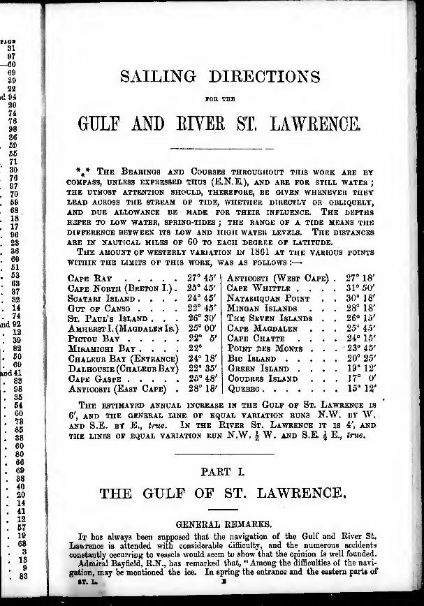
The AMOUNT of westerly VARIATION IN 1861 AT THE VARIOUS POINTS
WITHIN THE LIMITS OF THIS WORK, WAS AS FOLLOWS :
—
24° 45'
22° 45'
26° 30'
25° 00'
22° 6'
22°
24° 18'
22" 35'
Cape Ray 27° 45'
Cape North (Breton I.) . 25° 45'
ScATARi Island ....Gut of Canso ....St. Paul's Island . . .
Amherst I. (Magdalen Is.)
PiCTOU BayMiRAMicHi Bay ....Chaleur Bay (Entrance)
Dalhousie (ChaleurBay)Cape Gaspe 25° 48'
Anticosti (East Cape) . 28° 18'
The estimated annual increase in the Gulp of St. Lawrence is
6', and the general line of equal variation runs n.w. by w.AND S.E. BY E,, true. In the River St. Lawrence it is 4', andTHE LINES OF EQUAL VARIATION RUN N.W. J W. AND S.R ^ E,, true.
Anticosti (West Cape)Cape Whittle . .
Natashquan PointMiNGAN IslandsThe Seven IslandsCape MagdalenCape Chatte . .
Point des Monts .
Bic Island . . .
Green Island . .
CouDRES IslandQuebec
27°

ICE AND FOGS.
the Gulf are froauciitly covered witli it, iind vessels nro sometimes Voset for manydays. Heing untitt.jd lor contending with the danger, they often Huller from it, and
are occaHionally lost ; hut serious accidents from this cause do not frequently occur,
because the ice is geni'raliy in a melting state from the powerful effect of the sun in
spring. In the full of the year accidents from ice seldom occur, except when the
winter commences suddenly ; or when vessels linger imprudently lato from the temp-
tation of obtaining high freights.
Hut all danger from ice is far less than that which arises from the prevalent fogs :
they may occur at any time during the open or navigable season, but are most fre-
quent in the early part of summer ; they are rare, j-nd never of long continuance
during westerly winds, but seldom fail to accompany an easterly vvind of any strength
or durution. Tlie above general observation is subject, however, to restriction, ac-
cordiu"- to locality, or season. Thus winds between the south and west, which are
usually clear weather winds above Anticosti, are frequently accompanied with fog in
the eastern parts of the gulf. Winds between the south and east are almost always
accompanied with rain utid fog in evtry part. E.N.E. winds above Point de Monts
are often E.S.E. or S.E. winds in the Gulf, changed in direction by the high lands
of the south coast, and have therefore in general the same foggy character. I speak
of winds of considerable strength and duration, and which probably extend over
great distances. Moderate and partial fine weather winds may occur without fog at
any season, and in any locality. In the early part of the navigable season, especially
in the months of April and May, clear weather N.E. winds are of frequent occurrence,
and they also sometimes occur at other [seasons, in every part of the Gulf and Kiver
St. Lawrence.
The fogs sometimes last several days in succession, and to a vessel either running
up or beating down, during their continuance, there is no safe ^uide but the constant
use of the deep-sea lead, with a chart containing correct soundings.
The fogs which accompany easterly gales, extend higher up into the atmosphere,
and cannot be looked over from any part of the riirging of a ship. They, however,
are not so thick as those which occur in calms after a strong wind, and which are
frequently so dense as to conceal a vessel within hail ; whilst the former often, but
not alvv..ys, admit the land, or other objects, to be distinguished at the distance of
half a mile, or more, in the daytime.
The dense fogs which occur in calms, or even in very light winds, often extend
only to small elevations above the sea ; so that it sometimes happens, that whenobjects are hidden at the distance of fifty yards from the deck, they can be plainly
seen by a person fifty or sixty feet up the rigging. In' the months of October andNovember the fogs and rain that accompany easterly gales, are replaced by thick
snow, which causes equal embarrassment to the navigator.
The prevailing winds, during the navigable season, are either directly up or
directly down the estuary, following the course of the chains of high lands on either
side of the great valley of the St. Lawrence. Thus a S.E. wind in the Gulf becomesE.S.E, between Anticosti and the south coast, E.N.E. above Point de Monts, andN.E. above Green Island. The westerly winds do not appear to be so much guidedin direction by the high lands, excepting along the south coast, where we haveobserved a W.S.W. wind at the island of Bic becoming West, W.N.W., and N.W.,as we ran down along the high and curved coast, until it became a N.N.W. windat Cape Gaspe. These winds frequently blow strong for three or four days in suc-
cession ; the westerly winds being almost always accompanied with fine, dry, clear,
and sunny weather j the eastei'ly winds as frequently the contrary, cold, wet, and foggy.
In the spring, the easterly winds most prevail, frequently blowing for several weeks msuccession. As the summer advances, the westerly winds becom'^ more frequent, andthe S.W. wind may be said to be the prevailing wind in summer in all parts of thelliver and Gulf. Light south winds take place occasionally ; but north winds are notcommon in summer, although they sometimes occur. Steady N.W. winds do notblow frequently before September, excepting for a few hours at a time, when theygenerally succeed easterly winds which have died away to a calm, forming the com-mencement of strong winds, and usually veering to the S.W. The N.W. wind is dry,with bright clear sky, flying clouds, and showers. After the autumnal equinox, winasto the northward of West become more common, and are then often strong steadywinds of considerable duration. In the months of October and November the N.W.
"WIND AND WEATHER. §'-
wiiul frcfmeiill} 1)1<)\vh with j^iciit violtMice in heavy squallH, witli passing showers ofhull and hhow, and attcndid with Mharp IVost.
Thun(h'i'-Htornirt are not uncommon in .Inly and Au^'unt ; thoy seldom la^t uhovean hour or two; but the wind proceeding from them is in gencrul viohMit and nud-den, mirticnhirly when near the mountainouM part of tlie coast ; sail should, there-fore, be fully and (luickly reduced on their approach.
Stron<^ winds seldom veer (puckly from one quarter of the compass to anotherdirectly or nearly contrary : in general they die away by df«,'ree» to a calm, and arusucceeded by a wind in the opposite direction. I do not mean, however, by thisoljservation, that they may not veer to the amount of Heveral points. N.W. windsseldom or never veer round by North and N.E. to East and S.E. ; but they dofrequently, by degrees, to the S.W., alter becoming moderate. S.W. winds seldoiik
veer by the N.W. and North to the eastward, but sometimes by the 8outh to S.E. andEast. Easterly winds generally decrease to a calm, and are succeeded by wind fiomthe opposite direction.
In the tine weather westerly winds of summer, a fresh topgallant breeze will oftttn
decrease to a light breeze or calm at night, and spring up again from the samoquarter on the following morning: under these circumstances oidy may a land breezeotf the north coast be looked for. I have observed the same ott'the south coast also,
but not so decidedly or extending so I'ar off shore. I have occasionally carried the
north land wind nearly over to the south coast just before daylight, but have neverobserved the south land wind extend more than five or six miles off, and that veryrarely. Under the same circumstances; that is, with a fine weather westerly windgoing down with thesim, a S.W. land breeze will frequently be found blowing oil' the
north co*ist of Anticosti at night and during the early part of the morning. If, how-ever, the weather be not settled fair, and the wind does not fall with the sun, it will
usually prove worse than useless to run a vessel close in shore at night in the hopeof a breeze otf the land Such is the usual cour.se of the winds in common st^asons,
in which a very heavy gale of wind will probably not be experienced from May to
October, although close-reefed topsail breezes are usually connnon enough. Occa-sionally, however, there are years, the character of vyhich is decidedly stormy. Gules
of winds, of considerable strength, then follow each other in quick succession andfrom opposite quarters.
The marine barometer, which is at all times of great use to the navigator, becomesparticularly so in such seasons ; and the following remarks upon its general indica-
tions, when taken in connexion with the usual course of the winds and weather in
the St. Lawrence, may therefore be useful. The barometer has a range from 29 to
30'5 inclii'S in the Gulf and Kiver St. Lawrence during the navigable season, and its
changes accompany those of the winds and weather with a considerable degree of con-
stancy. The fluctuations of the barometric column are much greater and morefrequent there than in lower latitudes ; and sudden alterations, which in other
climates would be alarming, may occur there without being followed by anycorresponding change either in the wind or the weather. But the navigator
should not be inattentive to those minor changes, as a constant attention to the
instrument can alone enable him to appreciate those decisive indications of tlie
mercury which seldom or never prove deceptive. The following remarks will
apply to those well-marked changes which usually indicate the approach of a
gale of considerable strength, or of a shift of wind and weather; the correct
anticipation of which is often of the \itmost importance to the safety of a vessel,
as well as to the length of her voyage. When after a continuance of westerly
winds and fine weather, the barometer has risen nearly to its greatest height, say
some tenths above thirty inches, or begins to fall a little, an easterly wind maybe soon expected. If to this notice given by the barometer be added a warmhazy atmosphere during the day, and a heavy precipitation of dew at night, with
very bright twinkling stars, or a coloured aurora borealis, the approach of aneast wind is almost certain. If land be in sight at such a time, and appears
much distorted by terrestrial refraction, or if vessels in sight have the relative
proportions of their hulls and sails changed by the mirage, or present double or
treble images, such appearances will render the more probable indications of the
barometer certain. At the commencement, the easterly wind will probably bo
light with fine clear weather, but this will not last above a few hours if thu
B 2
4 THE BAKOMETER.
barometer continuoB to fall ; on the contrary, tlio wind will grndimlly incrense,
and iw it doen ho, the sky will bo ovcrouHt by dejfrecH \intil it iH conii>lt'tely clouded.
liotU rain and fo^ will follow, and continue dnrinj? the continuance of the easterly
wind, with little intennisBion, until they are di»Bipated by u fresh breeze from the
contrary quarter.. , ,
If the fall of the barometer, durinj? the continuance of tlie easterly wind, be very
slow, the gale will probably continue, and not be very violent : if rapid, it will pro-
bably be ol" Hhort duration, and of gveater strength : at any rate, when the moicury
falls towards 29 inches, a change is certainly at hand, and the gale will in general come
from the N.W. The strength of this gucceeding gale will be in proportion to the fall
of the barometer, and to the strength of the easterly gale which preceded it. In such
a case, there is seldom many hours' interval between the one gale and the other. The
oaet wind generally dies away to a calm, and in a very few hours, or sometimes in much
less time, the N.W. gale springs up. A heavy cross sea remains for some time from
the previous gale. The barometer sometimes begins to rise in the interval of calm
which precedes the N.W. gale, at others at its commencement : the fog and rain cease,
and tiie weather becomes quite clear, generally in a few hours, and sometimes almost
immediately. The strength of the westerly gale is usually greatest soon alter is
commencement, and diminishes as the barometer rises, veering gradually to the Wesand S.W. It is worthy of remark, that the circumstances just mentioned are exactly
the reverse of those attending the easterly gale. The gale usually commences with
clear weather and a high barometer, light at first from the South or S.E., and
gradually increasing as it vecns to the eastward, with a falling barometer. To return
to the westerly gale. If, after it has veered to S.W. and become moderate, the baro-
meter remains steady at a moderate height, fine weather may be expected. If it
remains at a cor.siderable height, but still fluctuating and unsteady, within certain
limits, variable but not heavy v/inds, and variable iveather, may be expected. If, on
the contrary, it rises quickly to a great height, a repetition of the easterly gale will
not be improbable. We have experienced seasons in which the barometer may be
said to have been no sooner blown up by one wind, than it has been blown down by
another, and this stormy alternation to have continued for several months, whilst in
others we have scarcely had a double-reefed topsail breeze during the whole summer.There is in fact so great a ditl'erence in the phenomena of the weather in different
seasons, that it becomes very difficult to write anything respecting it that shall not be
liable to many exceptions. There are, however, some strongly marked cases of con-
nexion between the indications of the barometer and changes of the winds andweather, which, within our own experience of eight or nine years, hav9 been subject
to few, I might almost say no exceptions. The first of these cases is that mostcommon one, which I have endeavoured to describe, of an easterly gale, with a falling
barometer, being always wet and foggy, and succeeded by a strong wind from the
opposite quarter with a rising barometer. A second case, not of so frequent occur-
rence in common seasons, excepting in spring or early in summer, is the easterly
wind with a rising barometer ; which, although it may not be at first for a few hours,
will almost always become fine and clear, and end in fine weather. A. third case maybe considered certain : if the barometer fall suddenly and greatly, at any time, anortherly, and most probably a N.W. gale, of great strength, may be confidently ex-
pected. It does not follow that it will be immediate, for it may be preceded by astrong gale from S.W., for a few hours, during which the barometer will seldom rise,
and even, probably, continue to fall ; but when the S.W. gale dies away, the northerly
or N.W. will soon succeed, with a rising barometer.
In conclusion, I may remark that as, on the one hand, a considerable fall of thebarometer ma^ occur, without being followed by a strong wind ; so, on the other, abreeze of considerable strength may come on without any indication from the baro-meter, but not anything that deserves the name oi & gale. There has never, withinour exp< ence, occurred a gale, so heavy as to be of serious consequence to a goodvessel, the approach of which has not been indicated by the barometer. But it mustbe remembered, that a high barometer, in this climate, and under the circumstanceswhich I have mentioned, is often indicative of an easterly gale. It is remarkable that,
in the gulf and estuary of the St. Lawrence, a high barometer may be considered asthe forerunner of wet and foggy weather, which usually accompanies its fall ; whilsta low barometer renders it equally probable that dry weather will ensue, since it often
.
TUB COMPASS, CURRENTS, «&o.
accompanies its rise. I am fully of opinion, that tlio marine Imrometor ih of tlio
greatest assistance in the nuvijfation of the Gulf and Uivor St. Lawronce, and that byattt'iidinjf coiiHtantly to its state and chanpw, with relerenco to the winds and weatherwhich preceded them, combined with the indications afforded by the appearance of thesky, Sic., those clianj,'es of the wind and weather, which are about to take place, maybo Miiticipat.d with a dejjree of certainty sufficient, in most cases, to enable us to avoidbeiiif^ caufjht on a lee-shore, or in an unsafe anchoraj^e, as well as to regulate ourcourse in a voyage, in anticipation of the coming change.An opinion is prevalent that the compasses of vessels are disturbed in the Gulf
and Kiver St. Lawrence, and such disturbance has been attributed to the magneticores of iron in the hills, particularly those of ths north coast. The magnetic oxideof iron does exist abundantly, and attracts the nedle very powerfully at some points,
Sarticularly along the coast from the Bay of Seven Islands eastward. Among thelingun Islands, we found the variation to vary from this cause from 19° to 31'' W.
At Port Neuf, and on Manicouagon Point, the needle was also diaturbed. Put these
effects were only noticed when the instrument was placed on the shore. In twoinstances onlv, when sailing within two miles of the shore, have we observed anyeffect of the kind upon the compai.ses on board the Gulnare (the vessel in which thesurvey was made), and then only to the amoimt of a few degrees.
When running from place to place, at greater distances from the coast, nothing ofthe kind has been noticed ; so that I feel sure, that in nine cases out of ten, wliero
this source of erroneous reckoning has been alleged as the cause of accidents to
vessels, they originated either in errors of the chart, or iu tha local attraction onboard the vessels themselves."
CUllliENTS, &c.—Admiral Bayfield, R.N., says—"It is a generally received
opinion, that a current sets constantly to the soujji-eastward out of the Gulf of St.
Lawrence, between Newfoundland and Cape Breton Island, and also that it is frequently
deflected to the southward, towards the shores of the island last named, by anothercurrent from the northward, which is said to enter the Gulf by the Strait of Belle Isle.
I have mjyself observed tliat a current sets out, between Cape Ray and St. PaulIsland, durmg westerly winds and in calm weather ; but it is checked by easterly
winds, and I believe that it may sometimes run in a contrary direction from the same •
cause. Northerly wind.-., and perhaps also the above-named current from the north-
ward, may cause the stream to set to the southward towards Cape Breton Island.
But the truth is that winds, both present and at a distance, possess so powerful andiiTegular an action upon the set and strength of the currents and tides in this entrance
of the Gulf, that I can say nothing certain or definite respecting them.The reality of a current inwards through the Strait of Belle Isle is confirmed by
the presence of icebergs, which it transports into the Gulf tjvery summer, against the
prevailing S.W. winds ; frequently cttrrying them as far as Mecattina, and sometimeseven to the neighbourhood of the east point of Anticosti. Its strength is very muchincreased by a prevalence of N.E. winds : at such times it runs at the rate of 2 knots,
through the Strait, and for 30 to 40 miles further to the westward ; diminishing
gradually in force as it spreads out in the wider , ts of the Gulf. Usually, however,
its rate is much less. At times, when S.W. windb nrevail, it becomes very weak ; andit has even been reported to me, that a current hac been observed setting out of the
Gulf, in a contrary direction to the N.E., for days together, but this was never observed
by us during either of the three seasons which we passed there. There is, however,
no doubt that this current is extremely irregular, as might be expected at the narrowoutlet of a great inland sea, where winds, both within and without, must of necessity
possess great influence.
After entering the Gulf, it runs along the north or Labrador Coast, at the distance
of 2 or 3 miles from the outer islands ; leaving a narrow space in-shore, in which the
streams of the tides, when uninfluenced by winds, are tolerably regular. Passing out-
side of Mistanoque, the islands of Grand Mecattina, and the Southmakers Ledge, it
pursues a direction given to it by the trending of the coast, till it is turned gradually
to the southward, by the weak current whicb is often found coming from the westwardbetween Anticosti and the north coast, during westerly winds, and which is set off to
the southward from Natashquan Point. The tmited streams continue their southern
course at a rate diminishing as they become more widely spread, and which seldom
exceeds half a knot ; and, finally, joining the main downward current out of the gt.
6 CUEEENTS, &c.
1
1
Lawronce, of which an account will be given immodiatoly, thoy all pursue a S.E-^
direction towards the main entrance ol' the Gulf, between Ca^xj Uay and the Island of
St. Paul. It is this current, IVom tae northward, which is felt by vessels crossing
from off the Bird Rocks towards Anticosti; and which, I'^gether with neglecting to
allow for the local attraction of the compass, has been the principal cause of masters
of vessels so often finding themselves, unexpectedly, on tlie south coast. Many ship-
wncks have arisen from this cause near Cape Rosier Gasp<?, Mai Bay. &c.
JiJffect of the Tides on this Current.—Both these currents, viz., that from the north-
ward, and the main downward current of the St. La,"vence, are modified by the tides,^
but in a way directly contrary : fov the northern curi'ent, in through the Strait of
Belle Isle, is accelerated liy the flood, and checked by the ebb; whilst the other is
accelerated by the ebb, and checked by the flood tide. These modilying causes, viz.,
the tides and winds, give rise to various combinations, and consequent irregularities,
in the direction and strength of these streams, which it is extremely difficult at all
times to estimate and allow for correctly.
Main Current of the River.—The current along the south coast appea'is to be
superficial : at least we found it so in the lower parts of the Estuary, where observa-
tions upon the specific gravity of the water on the surface, and taken up from different
depths, proved to us that the water of the St. Lawrence and its numerous tributary
streams was widely diffused over the Estuary. It has also been observed that tha
current is sv.'ongest in spring, soon after the opening of the navigat'.on, when the
rivers are swelled by the recently dissolved snows of the winter. But, tJthough, gene-
rally speaking, there seems no doubt that this current is the tribute of the St. Law-rence on its way tc the ocean ; yet, in the upper part of the Estuary it is not alone,
and at all times, caused by the discharge of the St. I^awrencie, but depends also uponpeculiarities in the set of the tides^ Thus, when our observations had confirmed the
truth of the report, that the current always ran down on the south side of the Estuaryfrom a few miles below Red Island towards tha Island of Bic, we could not {-t first
account for the fact; for it appeared impossible that this could be the comparativelyfresh water of the St. Lawrei.ce flowing on the surface towards the sea, when we knewthat the whole body of water a fe' : miles above, from shore to shore, on either side of
. Hare Island, and alfCo in the Saguenay River, was running up during the flood tide.
Attent"'>n, and numerous observations, together with an examination of the tempera-ture ..a specific gravity of the water, informed us that this was an eddy flood, whichis thus explained.
The flood tide ascends in a wide channel more than 100 fathoms deep : when it;
arriv3s at the comparatively narrow pass formed by Green Island, Red Islet Reef, andthe extensive shoals off the entrance of the Saguenay River, it is obstructed thereby,ns well as by the shoalness of the channel to the southward of Hare Island. ThereIS not room for so great a volume of water to pass, and part of it is in consequenceturned back, and forms &n eddy flood, setting trom below Red Islet Reef, towards theRazade Islets. During the ebb tide, the stream of the Saguenay sets over to thesouthward in the same direction, hence the current on that side is always down.There is no upward stream of the tide (excepting so close in-shore as to be useless
to ships) all along the south coast from Cape Gaspe to a few miles below Red Islet, inconsequence of the union of this eddy flood with the main current of the river ; an''
they have, therefore, so much influence ou the navigation that I shall endeavour t ^
trace their course more particularly.
Commencing from a short distance below the Red Islet Reef, the current is therevery strong—about 4 knots. It decreases in velocity as it proceeds to the south-east-ward, slanting over towards the Razade Islets ; ott' which its rate is from 2 to 3 knots.It runs strongly along the northern edge of the Bank of Soundings off the south coast,upon which, especially in spring tides, a weak stream of flood will be found flowingm the opposite direction, and the boundary of the two streams is usually marked bya strong ripple. I'rcm Father Point to Cape Chatte, the rate of the downwardcurrent varies from a | to 2 knots, according to the tide, direction of the wind, andseason of the year.
During the ebb tide the stream runs down on both sides, stronger on the souththan the north coast, and weakest in the middle of the Estuary. It is deflected, orturned off to the southward, by the Points Mille-Vaches, Bersimis,Manicouagan,andPoint de Monts, and by the ebbing streams of the large rivers between them j a circum-
^S.E.
and of
ossing
ing to
lusters
ship-
the
CUEEENTS, &o. 7
stance which should be carefully attended to hy vessels coming up with a northerlywind ; as they will infallibly be set over to the southward upon a lee shore, if they donot make the necessary allowance by keeping their wind well over to the northward.
During the flood tide this stream still continues to run down outside the Bank ofSoundings off the south coast, although with diminished velocity, and is felt about halfway over towards the north shore. In the middle of the Estuary there is usuallyslack water; whilst along the north coast the stream of flood is regular in its recur-rence,^ increasing in force as we ascend the Estuary. The strength of the stream offlood 13 greatest in-shore, and diminishes as we proceed over to the southward, till atthe distance of about 3 leagues it becomes insensible. These differences in thestrength and direction of the streams produce strong ripples in various parts of theEstuary, but their position varies with the different times of tide, and perhaps fromother causes, so that they cannot safely be trusted for any guidance to the sen man.Eound Point de Mont.< there is little or no stream of flood, excepting very close
in-shore ; the downward current is constant, or nearly so, off that point ; and it
requires a fast-sailing vessel to beat round it against a westerly v/ind. Point de Montsturns this current over to the S.S.E., at a rate varying from 1 to 2 knots ; so that avessel, having a west wind, and standing over to the southward on the starboard tack,
will be carried towards the south coast at a r<ipid rate, having the current on herweather quarter ; during her board tack to the northward she will be retarded, tiie
current being then directly opposed to her course. When sailing at the rate of 4knots, it will usually require only about half the time to go from near Point de Montsover to the south coast, that it will take to return from tlie latter to the former. Thisis a most important circumstance, which it is necessary to carefully guard agni'.ist, whenbeating up the Estuary in this part during dark nights, and especially in foggy weather.
Below Point de Monts tht) current is no longer fel'i; neai the north coast, nor,
indeed, anywhere to the northward of a line joining Point de Monts and Anticosti.
It is confined to the neighbourhood of the south coast, which it follows in its curveto the southward, running strongly past Cape Gaspe, Flat Island, and BonaventureIsland ; whence, curving gradually to the South and S.E., it continues its course
towards the entrraice of the Gulf^ with a rate very much lessened in consequence ofthe gi'eat space over which it is now spread. The usual breadth of this stream fromMagdalen River to Cape Gaspe is 3 or 4 leagues; but this, I believe, is not uniform.When S.W. winds prevail, it appears that this current, or a branch of it, is driven
over from the vicinity of Magdalen River towards Anticosti;part of the stream
ruiming round the west point of that island, sets across nearly towards Large Island
(one of the Mingans), whence turning gradually down outside the Mingan andEsquimaux Islands, and along thfl north coast, it sweeps round the curve to the
westward of Natashquan Point and is turned off to the southward, as has beenalready mentioned. The other part sweeps round the large curve, or bay, betweenthe west and S.W. points of Anticosti, and is turned off to the southward by the latter
point, frequently causing a great ripple off it, which has been mistaken for breakers
on a mucli more extensive reef than exists there.
I have noted the rate of this current, off different parts of the south coast betweenCapes Chatte and Gasp^, in the months of June, July, August, and September, andin different years, and scarcely ever found it the same. It varipd between 1 and 2knots in westerly winds. It was weaker, often nearly hisenslble, in easterly winds
;
and in one instance, off Mont Louis River, in a calm which was followed by a strong
breeze from the eastward, it could not be perceived.
Vessels beating up the St. Lawrence against westerly winds usually experience
little difficulty in making good way to windward, after having weathered the westpoint of Anticosti and arrived on the north coast: because there is seldom anycurrent on that side, and the tides, although weak, are tolerably regular. It is in
general very easy to beat from the Seven Islands to Point de Monts ; for there the
stream of flood is stronger than the ebb ; the latter, as well as the current, being
turned off to the southward by Point de Monts. There seems, at times, also to be
an eddy current there, sweeping round the great bay or curve between the above-
named points. It sets off from above Egg Islet to the S.S.W. ; and is the probable
cause why vessels, which shape a direct course |'or Point de Monts with a leading
N.W. wind off the land at night, so often find themselves obliged to haul up for, or
unable, to fetch the light."
8
ST. PAUL'S ISLAND, THE MAGDALEN ISLANDS, BRYON ISLAND,THE BIRD ISLETS, ANTICOSTI.
ST. PAVl'S XS&AirB.—This island is nearly 3 miles long, and 1 mile broad.
The bearing and distance from the south point of the island to Cape North are,
W.S.W. ^ W., 13 miles ; and from the north point of the island to Cape Ray, the
bearinj? and distance are, E. by N., 41^ miles. The margin is i > liv and precipitous
almost all round, indented by coves, in which shelter, during the prevalence of
certain winds, may be obtained. A small detached islet forms its N.E. point,
which is separated by a very narrow channel, from a peninsula, between 300 and
400 feet higii, which, together with the isthmus, is so precipitous as to bo nearly
inaccessible.
Two octagonal-shaped white lighthouses are established on this island ; one onthe northern end, and the other on the southern point, one of which will always be
open, unless to a vessel very near the central rocks. The northern light is fixed,
and visible about 20 miles all round the compass, except on the bearings between N.by E. and E. by N., when it will be obscured by the hills to the southward oi it.
The southern light revolves once in every minute, at about the same elevation as the
northern one (140 feet), and is also visible about 20 miles on all bearings, except
those between West and S.S.E., when it is concealed by the land. At the southern
lighthouse a bell is kept tolling in foggy weather, worked by machinery, and a gunfired every 4 hours, commencing at 4 a.m.
About a mile from the south point on the west side of the island, is Trinity Cove,
at the northern part of which is a provisi(m post ; and on the opposite side of theisland is Atlantic Cove : a landing may be effected in either of these. The cove onthe N.W. affords a small and bold beach, about 150 feet long, where a landing maybe effected, but generally with difficulty, by reason of the continual swell of the sea.
The interior of the island rises into three hills, the highest being nearly in the
centre, and terminating in a square summit of about 50 feet on each side, nearly
perpendicular, and estimated to be about 500 feet above the level of the sea. Thesurface of the island is, in general, rocky, with some spots of marsh or bog, whichprobably supply the fresh water issuing from the rock. Stunted fir and white birch
trees are the only products of the isle, but some drift wood may be picked up.
There is anchorage all round the island, and close in-shore, which circumstanceenables vessels to lie there with any winds, by shifting their stations as the wind andweather require ;—a mode practised by the privateers of the United States duringttie late war. There are tolerably regular soundings off the north side, at thedistance of half or three-quarters of a mile ; on the N.E. side a bank lies off aboutthree-quarters of a mile, with from 7 to 8 fathoms of water. The general depth ofthe soundings around the island, at half a mile from the shore, is from 20 to 40, butthe water soon deepens to 100 fathoms, so that there is little or no warning by thelead when approachmg this island in foggy weather. There is a plentiful fishery ofcod and mackerel around the coast, and also an abundance of seals.
MAODAXiliX XSitAXTDS.—These islands form a chain, in an irregular curveddirection, and lie between the parallels of 47° 12' and 47° 39' N. The Magdalens,wheu first made from sea, appear like several hilly islands, with channels between
;
but, on a nearer approach, they are seen to be all connected together, with the excep-tion of Entry Island, by a double line of sand-bars and beaches, enclosing extensivelagoons, having very narrow entrances, by which the tide finds access and egress.In some parts these sand-bars are only a few feet above the sea, whilst in othersthey rise into hills of sand of considerable height. They appear to be increasing,since there are generally lidges of sand, with from 9 to 12 feet water, parallel to andfrom 50 to 100 fathoms outside the beach. Between these ridges and the shorethere are 3 and 4 fathoms of water, a circumstance which has proved fatal to thecrews of vessels wrecked upon these shores. The central parts of these islandsattain an elevation of 200 to 580 feet. They contain a population of about 1100inhabitants, whose priu^ipal dependence is upon the cod-fishery. Wood, for fuel, isscarce near the settlements, and large spars are not to be had. Small supplies offresh provisions may be obtained, especially from Entry Island ; and water may behad from Amherst Harbour. These islands possess no harbours for ships ; but thereare three fit for small vessels, named Amherst, House, and Grand Entry Hai-bours.
1

THE MAGDALEN ISLANDS.
The names of the islands are Entry Island, Amherst, Grindstone, Alright, Wolf,Grosse, and Coffin Islands; exclusive of 13ryon or Cross Island, and the Bu-d Islets,
which lie more to the north.
AMHERST ISLAND.—The most southerly and principal island of the group is
Amherst Island, which is connected with Grindstone Island by a double line of sand-
bars, enclosing an extensive lagoon, 6 or 6 miles long, and from 1 to 3 wide, the
southern part of which is named Basque Harbour : it has three outlets into Pleasant
Bay ; the southernmost is the deepest, but has only 3 I'eet at low water. To the east
of this, and N.E. of the island, is Pleasant Bay, which is the best roadstead in the
Magdalens, and the only one where vessels can venture to lie with all winds, duringJune, July, and August. The best anchorage is in 4 fathoms, with the rocky point of
j the entrance of Amherst Harbour bearing S.W. ^ W. two-thirds of a mile. AmherstHarbour is situated in the S.W. corner cf Pleasant Bay ; its entrance is very narrowand crooked, and over the bar is 7 feet least water.
The hills in the interior of Amherst Island rise to the height of 550 feet above the
sea. Towards the S.E. part of the island, and about a mile to the N.W. of AmherstHarbour, is the very remarkable conical hill, named the Demoiselle, 280 feet hig!:.
At 7f miles, N.W. ^ W., from the western part of Amherst Island, is situated Dead-man's Islet, which is about 3 cables in length, and 1:|^ in breadth, and is about 170feet high ; a reef extends from it, about one-third of a mile, towards Amherst Island.
At 7 uiiles N. 60° E. from Deadman's Islet, and 5^ miles W.N.W. from Gull
Islet is a very dangerous reef, named the White Horse, which is small, only about a
cable's length in diameter, and has but 10 feet water over it ; on it the sea otten
GRINDSTONE ISLAND.—This island is the next largest of t)ie group, being,
in respect of size, intermediate between Amherst and Alright Islands. Its highest
point is elevated 550 feet above the sea at high water. On the west side of the
island is a dangerous reef, with 18 feet least water, named the Pierre de Gros Cap,
which is seldom seen, as the sea breaks upon it only in very heavy weather : it lies
N.E. by E. ^ E., e miles from the White Horse; N.W. by W. from Hospital Cape;and 3f miles from Cape la Trou, the nearest part of Grindstone Island ; this reef, as
well as White Horse Reef, may be cleared on the west side by not bringing Dead-man's Islet to bear westward of S.W. ^ W.ALRIGHT ISLAND.—This island lies to the eastward of Grindstone Island.
Cape Alright is the southern point of the island, and is remarkable, the cliffs being of
a greyish-wh'.te colour, with occasional brick-red low down, and 400 feet high. Thesouth extremity of the cape is low, with a small rock close off it. To the N.W. of
Cape Alright, about 2f miles, is the entrance to House Harbour ; it is narrow andcrooked, with only 6 i'athoms water in it.
Alright ReefWes S. 80° E., 3^ miles from Cape Alright, to the outer edge of the
reef, which is 400 fathoins long by 300 wide ; it is of white pointed rocks, havingonly 6 feet over them. To clear it on the S.W. side, keep the well-marked summitof Grindstone Island open to the south-westward of Cape Alright ; and to clear the
S.E. side of the reef, keep the east side of the woods of Wolf Island (seen over the
bars) open to the eastward of Shag Island.
WOLF ISLAND.—From Grindstone Island the sand-beaches continue in a north-
easterly direction, for 10 miles, to Wolf Island, which is about three-quarters of a
mile long, with low sandstone cliffs ; from Wolf Island the sand-beaches recommenceand continue, with occasional sand-hills, 9 or 10 miles farther, to the North Cape in
Grosse Island. A rocky shoal, of 3 fathoms, named the Wolf Rocks, lies about half
a mile from the shore off Wolf Island, and 10 miles north-eastward of Hospital Cape.
GROSSE ISLAND.—The northern point of Grosse Island is the North Cape gf
the Magdalens, and is a precipice of considerable height. The North Cape Rocks lie
to the westward of the cape, the outermost being about 600 fathoms from the shore.
The sandy beaches and hills continue, from Grosse Island, curving to the eastward,
6 miles farther up to the East Point.
The East Point of the Magdalens is of low sand, enclosing several shallow ponds,
and having several sand-hills, extending westward to the N.E. Cape. Off the East
Point is the Long Spit, a ridge of sand, with from 2 to 3 fathoms of water, extending
1^ miles S.E. ^ S. from the point ; and for 1:^ miles farther in the same direction the
depth is from 4 to 6 fathoms. To clear this spit in 5 or 6 fathoms, take care not to
10 BIED ISLANDS, &o.
bring Old Harry Head, the N.E. point of Coffin Island, to bear to the southward of
West. It is extremely dangerous, and there is a heavy breaking sea on it.
Duffle Hecf lies 8.E. ^ E. 6f miles from the East Point. The least water on it is
3 fathoms on one spot, and 12 to 13 fathoms all round it. It seldom shows, but is
one of the worst dangers of the Magdalens. The only mark to clear it is the North Capeof the Magdalens open two-thirds of its breadth to the N.E. of the North-East Cape,
which is a remarkable hill, 230 feet high, on East Island, which stands at the head of
Grand Entry Harbour, and can be seen over all the sand-hills.
COFFIN ISLAND.—This island lies to the S.W. of East Point, and its N.E. point,
named Old Harry Head, lies W.S.W. 4^ miles from it. The Columbine Shoals are a"
patch of rocks, with only 3 fathoms on then;, lying S.S.W. ^ W., 2| miles, from OldHarry Head. There are numerous small shoals and patches within them, towardsCoffin Island, on some of which are only 3 feet. This is a dangerous part, and should
not be approached at night, or during togs.
The entrance of Grand Entry Harbour, situated at the S.W. end of Coffin Island,
is extremely narrow, and ought not to be attempted without a pilot. The depth in
this entrance is not more than 10 feet least water, and the harbour itself is extensive
and well sheltered.
At 6 miles W.S.W. from the entrance of Grand Entry Harbour, is Shag Island,
which is small and low, and out of the way of vessels.
ENTKY ISLAND.—At 7 miles S. i E. from Cape Alright, is the N.E. point ofEntry Island, and the channel into Pleasant Bay lies between them, and also betweenAlright Reef and the Pearl Reef. The summit of Entry Island is 580 feet above the
level of the sea, and is visible 8 or 9 leagues off, in clear weather. The red clifi's ofthis island are magnificent and beautiful, rising at the N.E. point to 350 feet, and at
the south point to 400 feet. The S.W. cliffs of Amherst are also steep, but of less
height; and as there is no land to the southward and westward, it cannot bemistaken.
The Pearl Jieefin a small dangerous Reef of white-pointed rocks, having only 8feet water over it. It bears E. by N., 4^ miles, from the N.E. part of Entry Island,
and S.E. ^ S., 8:^ miles from Cape Alright : even with a moderate swell the sea breaksheavily upon it. Demoiselle Hill kept more than half a point open to the northwardof Entry Island, will clear it to the northward, and the same hill shut in with EntryIsland clears it to the southward.BSTON ZSKAITD.—This island is about 4 miles long in an E. by S. and W. by
N. direction, and is only a mile broad. The north side is the highest, and on thesouth side are some coves, where boats may easily land with the wind off shore. Itseastern end bears from the East Point of the Magdalens N. by E. | J'l lOi miles,but its S.W. point approaches to .vithin 8f miles of the North Cape of tnese Islands.A reef runs off from the S.W. end of the island 1| mile ; another from its east endI of a mile to the N.E. ; and there is a third running off to the southward from theb.W. point of the island, 1| mile. Close to the eastwai'd of the last of these reefsthere is good anchorage, in 4 or 5 fathoms, or in 6 fathoms a mile from the shore.Small vessels often ride out heavy N.W. gales under this island, close to the reef.
Between Bryon and Magdalen Islands the soundings are regular, from 9 to .11 fathoms,excepting a patch of foul and rocky ground with 5 fathoms upon it, lying betweenS.W. ^ W. and W.S.W. from the west end of Bryon Island. Although the soundingsin approaching Bryon Island are regular, great care must be taken in approachingthe reefs before mentioned, as they are very steep, especially the one running to thesouthward.
T8B BIRD ZSXiETS* are small and not far apart : they are of moderate height,and Hat and white at the top. In the passage between them there are rocks. Thesouthernmost is the largest ; from the east end of the N.W. Bird Rock there extendsa ledge of rocks.
Nearly midway between Bryon and Bird Islands there is a rocky shoal, said to haveonly 4 fathoms on it in one part, but not less than 7 have been found on it. This, a?well as the patch 3| miles W.S.W. of Bryon Island, should be avoided by large shipsin rough weather.
At 4 leagues to the eastward of the Bird Islands is the edge of the bank of sound-
I
• We believe it ifl intended to erect a lighthouse on one of these islets.
ANTICOSTI ISLAND. IX
inga, on which are 55 fatliomn. You should come no nearer the east side, in thickweather, than 40 fathoniH.
AWTTXCOSTI.—The island of Anticosli lies at the entrance of the River St. Law-rence, and is about 40 lea^mes in length by 10 in breadth. It is of moderate height,beinfjf estimated to be nowhere more than 700 feet high, and is extremely barren,aftording scarcely any support for the few quadrupeds which inhabit it. Although sodestitute of sustenance, yet streams of fresh water may be found on every part of thecoast, but generally too small even for boats. These streams become rapid imme-diately within their entrances ; and even the largest of them, Observation Kiver, tothe westward of the S.W. Point, is barred with sand, excepting for short intervals oftime after the spring freshets or heavy rains. There are no harbours or anchoring{)laces suitable tor large vessels. The only inhabitants are the people in charge of theighthouses and provision posts, -md at Fox Bay at the east end of the island.
Upon the island there are various provision posts established by the Governmentof Lower Canada for the relief of castaway crews, one of which is at Ellis Bay, 2leagues S.E. from the west end of the island ; the second at the lighthouse on the S.W.Point; a third at Jupiter River or Shallop Creek ; and a fourth at Heath Point.
There have also been placed direction boards at different parts of the island, nearthe beach, to assist persons, who may have had the misfortune to be wrecked, infinding the provision posts above mentioned, which are nailed to trees with their
branches cut off, to render the writing visible. They are, or were, placed as follows
:
—1st, on the west point of the island ; 2nd, 4 leagues south-eastward of Ellis Bay
;
3rd, 10 leagues westward of Jupiter River ; and the 4th, 7 leagues eastward ofJupiter River.
Heath Point Lighthouse is of the same form and colour as that on the S.W. point
of the island. It shows a bright fixed light from W.N.W. to N.E. by N., at 110feet above the sea, and can be seen 15 miles in clear weather. This lighthouse mustalways be kept open southward of Cormorant Point.
EAST CAPE.—The East Cape, in lat. 49° 8' 25" N., and long. 61° 39' 59" W., is
a perpendicular cliff, 100 feet high. To the southward of it, at the extremity of the
low land, is Heath Point, with its lighthouse. This building at a distance appears
like a sail, and is useful in marking the extent of low land to vessels either to the east
or west of North. Between Heath Point and East Cape is Wreck Bay, in which there
is no anchorage.
A dangerous reef runs off Heath Point about 2 miles in an E.S.E. direction ; be-
yon.d which are 5 fathoms, increasing to 7 fathoms at the distance of 3 miles I'rom the
point. To avoid it, come not nearer to the east side of the point than 20 fathoms ;
to the south-westward of the point the shoal water only extends off three-qua. ters of
a mile. A little farther to the westward is one of the best open anchorages on this'
side of the island, where you may anchor in 10 fathoms, with the lighthouse bearing
!Ei. by N., and Cormorant Point W.N.W., on a bottom of sand and mud, at nearly 2miles from the shore.
During westerly winds it would be dangerous to approach too near the east side
of Heath Point, for the winds coming along the land on each side of the island, some-
times do not meet until several miles to the eastward of the point. Between them youwill be becalmed, and a strong current round the point might set you upon the reef.
About 6 miles W. by N. from Heath Point is Cormorant Point, beyond which, at
the distance of Itt^ miles, is South Point, off which a reef runs nearly 1^ miles, causing
heavy breakers. To clear this reef at the distance of 2 miles, bring Heath and Cor-
morant Points in one bearing E. by S. South Point has a beacon 40 i'eet high uponit, situated in lat. 49° 3' 43" and long. 62° 18' 30" W.From South Point to the lighthouse on the S.W. Point, the distance is 56 miles,
and the intervening land has a similar appeal ance throughout. Between these points
are the Jupiter River or Shallop Creek, Pavilion River, and Salt Lake River and Bay.
At Jupiter River, which lies 13 miles N.W. of South Point, are the houses of the
provision establishment. Pavilion River lies 10 miles from Jupiter River, and its
locality may readily be distinguished by the beacon erected near it ; between, the
coast is all low, but may be approached safely by the deep-sea lead, the reefs nowhere
extending more than 1^ mile off. At nearly 21 miles to the north-westward of
Pavilion River are Salt Lake River and Bay, whence to S.W. Point the coast is
higher and bolder, aud should be approached with caution in foggy weather. When

12 ANTICOSTI ISLAND.
standing in-shore at nig;ht, do not bring the lifjhthouse to bear ^o the westward of
N.N.W. Off the centre of'Salt Lake Bay is indifferent anchorage in 7 fathoms, which
must be very cautiously taken ; six miles eastward of this bay there is a beacon, the
latitude of which is 49° 17' 30", and the longitude 63° 20' 30'' W.S.W. POINT.—The S.W. Point Lighthouse ia built on the extremity of the point.
The tower is built of grey stone, of a conical form, 75 feet high, and shows a bright
light, revolving every minute, which can be seen from N.N.W. round by west andsouth to S.E. by E. The lantern is 100 feet above the level of high water, and the
light can be seen 15 miles from the deck, and 19^ miles when the eye is elevated
50 feet. To the lighthouse is attached a provision post, which forms a conspicuous
landmark.
The S.W. Point is a low point, with a small cove on its north side, and has a reef
running off it about half a mile towards the we and south-west, 2 miles outside
of which are 30 fathoms. In this cove vessels may anchor in 12 or 13 fathoms, sand
and gravel, with the extremity of the point bearing S.S.W. ^ W., distant three-
quarters of a mile, sheltered from N. by E. to S. by W. ; but the anchorage is not
recommended, being exposed to westerly winds, and the ground being indifferent.
Hence to Ellis Bay the coast is lined by reefs extending out, in most parts, about amile with 10 or 12 fathoms close to them ; and there is no safe anchorage for vessels.
In running down this shore the lead should be kept going.
About 5 miles to the northward of S.W. Point is Observation River, the largest
stream on the island, having 5 or 6 feet water at the entrance, but barred with south-
westerly gales. On the north side of the river are some high sandy cliffs, and 16miles farther westward are some others, named the St. Mary's Cliffs, of less height
and less remarkable, but not difficult to distinguish, as their situation is pointed outby a beacon, in lat. 49° 40' 30", and long. 63° 58' W. Beyond St. Mary's Cliffs at
the distance of 7 miles is a small stream, falling into a cove, uamed the Becscie River
;
this cove affords shelter for boats.
Ellis Bay affords tolerably good anchorage. Its east point is named Cape Eagle,and its west point Cape Henry.A reef of flat limestone runs off a mile south-westward from Cape Henrv ; and
another reef runs off three-quarters of a mile to the westward from Cape Eagle ; theentrance between them is 600 fathoms wide, from 3 fathoms on each side. Both thereefs show themselves by a line of breakers.
In approaching this bay from the westward, run down along the reefs off CapeHenry in 10 i'athoms, until the west side of the White Cliff, which is on the east sideof the bay, comes on with the east side of the westernmost of two hills, back in thecountry, bearing N.E. | N., then haul up with these marks on, which will lead you•into smooth water, close under Cape Henry Reef, in 3^ fathoms. Continue runningon until Gamache House bears N. by E., then haul up for it, and anchor in 3 fathoms,muddy bottom, about half a mile from the flats at the head of the bay, and 300 fathomsfrom those on either side. Keep the lead constantly going.
In rurming for the bay from the eastward, with an easterly wind, keep along CapeEagle Reef, in no less than 7 fathoms, till the east side of the White Cliff comes onwith the east side of the same hill, as before ; then haul up till the houses bear N.by E., and proceed as before. It is high water at Cape Henry, full and change, atIh. 43m. ; spring tides rise about 7 feet, neaps 4 feet.
Ellis Bay may be readily known by Cape Henry, which is a bluff point, and theland at the head of the bay being low causes the entrance to show distinctly. Tworidges of hills, back in the country, will help to distinguish it.
WEST POINT is low and wooded, with reefs extending not more than a milefrom the shore. It may be safely rounded in 15 fathoms, at the distance of If mile.Between West Point and Ellis Bay, the shore is lined with reefs to the distance ofIf mile
; it must not therefore be too closely approached.West Point lighthouse consists of a circular stone tower 109 feet high, faced exter-
nally with fire-brick of a light colour, and the light, which is fixed, is shown at analtitude of 112 feet above the level of the sea, and may be seen in clear weather at adistarice of 15 miles. Lat. 49° 52^' N., long. 64° 32' W. The light is exhibitedtrom 20th March to Slst December. Signals are given by means of an air or fogwhistle, sounded at short intervals during foggy weather and snow storms j or, by amne-pouuder gun fired every hour whenever the whistle is out of order.
ANTICOSTI ISLAND. 18
The coast from West Point to North Point is low, with reefs* running off about amile, and should not be approached nearer than 25 fathoms. From North Point to
High Cliff, the distance is 13 miles, with a moderately low and wooded shore. HighCliff mav be easily known by being the only one on the island that has not its basewashed by the sea.
White North Cliff lies 26 miles south-eastward of High Cliff; this part of thecoast is dangerous, for at about one-third of the distance from High Cliff the reefs
extend fully 2 miles from the laud, and continue so for some distance. On approachingWhit« North Cliff they only reach about half a mile from the shore. White NorthCliff may be seen 6 or 7 leagues off, appearing like a white patch.
Carleton Point lies 10 miles south-eastward of White North Cliff; under this pointvessels may anclior in fine weather, and procure wood aud water.
About 10 miles south-eastward of Carleton Point is Cape Observation, a high, boldheadland, under which vessels may anchor during westerly winds and fine weather,
and obtain supplies of wood and water verv conveniently. Farther eastward, at the
distance of 12^ miles, is Bear Head, a similar headland to Cape Observation, and 400feet high, which last-named cliff may be easily recognised, as there are no high cliffy
headlands of equal height to the westward of it.
Between Bear Head and Cape Robert is Bear Bay, which is considered to be the
best roadstead on this part of the coast of Anticosti, as the bottom is excellent, the
dopth moderate, and the shelter extends from N.N.W. round by west and south to
S.E. by S. It is divided by two high cliffs into three bays, in each of which is a
fine beach of sand and shingle and a fresh-water stream. The best anchorage is in
13 fathoms, with Tower Point (the southernmost of the cliffs) bearing N.W. ^ W.,Cape Robert S.E. ^ S., and Bear Head N. by W. i W.To the south-eastward of Cape Robert, distant 19 miles, is Table Head, ^- markable
by its hill of a table form, immediately behind it ; the coast between contains several
small bays, but no anchorage. Four miles farther is Fox Head, much lower than
Table Head, and to the southward of the head is the bay, affording good anchorage
for small vessels during the summer months. The southern point ofthe bay is namedReef Point, and has a reef running off it fully 1^ mile, close off the end of which are
10 fathoms, so that to avoid it vessels should not approach nearer than 18 fathoms.
The north point of the bay has also a reef running from it, fully half a mile. Windsfrom E. by N. to E.N.E. blow directly in.
Hence to East Cape the coast is cliffy and about 100 feet in height, but bold andfree from danger. About half way is Cape Sand-Top, between which and East Capevessels may anchor during westerly winds, in 16 to 20 fathoms, fine sand, at a mile
from the shore.
THE NORTH COAST OF THE GULF.
CAPE WHITTLE TO THE MINGAN ISLANDS.
The first bay to the westward of Cape Whittle is WolfBay, a place full of rockyledges, but which, however, all show. On the west side of the bay is the island of
the same name, of a greater height than the islands usually are off this part of the
coast, being about 150 feet high, hence it is easily recognised ; nearly a mile S.W.by S. from it is a small low islet (Outer Islet), and 1^ mile S.W. by S. from this,* at
a spot where the depth has hitherto been considered 22 i'athoms, lies the GrangeSock, with only 16 feet water oyer it ; it is ^ a mile long, very narrow and steep-to.
* This is the position assigned to it by Capt. Orlebar, K.N., but Gapt. Grange, whose vesBel, the
S.S. North American, struck upon it in Sept., 1868, places it further out; he says, at that
time, the " outer islets, Wolf Island, were fair abeam, 3 to 4 miles distant, and very nearly in line,
bearing N.N.E. ^ £." It might, however, be, as Capt. Orlebar observes, " the whole of the coaiit
is dangerous of approach, and the appearance of the land under dlfTerent states of the atmospherevery deceptive as to distance.
Therefore, I would recommend no approaching nearer than snfScient to make ont objects ; andthat, at least in thick weather, vessels should maintain 50 fathoms water in running along the
land between Kegashka and South Breakers Ledge, for outside this depth there is no dang«r."

14 THE COAST OF LABRADOE,—
To the woHtwartl of Wolf iHlet in Coucoacho Bay, affording; the only nnchorage
for lurj^e vchsuIhoii tliis part ol' the coast, and wiiieh \» represented to be easy of access,
although the number of islets and rocks scattered about would convey a different
impression. At ihe head of the bay is the Basin, an excellent harbour, and another
harbour is formed by an arm running in an E. by N. direction, named the Tertiary
Shell IJiiy, which is equally sale. Farther out than these harbours the bay is more
than half a mile wide, and quite Bufficieutly sheltered for the safety of any vessel with
good anchors and cables.
Outside the entrance of the bay are two small dangerous ledges, named the South
and South-west Breakers, the first of which has only 12 feet on it, and shows only in
heavy weather; it lies W.N.VV. \ W. 2 miles from the small low islet (Outer Islet)
outside Wolf Island, and has, at ^ of a mile S.W. from it, another small and steep
siioal with 18 feet on it, which with the Grange Rock constitute the outermost
dangers on this part of the coast. The South-west Breaker has but 3 leet on it, andbears N.W. ^ N. 2^ miles from the South Breaker, and West 2^ miles from the
outermost of the Audubon Islets, on the west side of Coacoacho Bay.
The passage into the bay lies between these breakers, and in sailing in, the rule
is, to leave Outer Islet and the rocks to the northward of it, 300 fathoms to the
eastward, and when abreast of these rocks, a chain of low rocks, extending off to
the south-west of Emery Island, will be seen right ahead. Bring the point of this
chain to bear N.E. | N., when it will appear on with the extreme point of the main-
hind, on the N.W. side, near the head of the bay, and run in on this mark, leaving
some rocks, which lie 600 fathoms off the east side of Audubon Islets, to port, andthen haul to the northward a little, so as to leave the Emery Rocks on the starboard.
Their outer point bears N.N.E. \ E., 3 miles from Outer Islet, and when up to
them, the bay is open before you, and clear of danger. The farther in, the better
the ground, and the less the swell with S.W. winds, which are the only winds that
send any swell into the bay. Tertiary Shell Bay is quite clear, excepting a small rock,
one quarter of a mile within the entrance, which you must leave on the starboard
hand ; within it is pertiectly land-locked, with from 5 to 11 fathoms muddy bottom.
To enter the Basin, you leave Tertiary Shell Bay, and the point of low rocks to
the north ard of it, to the east, and continue the course till within half a mile of the
island, at the head of the bay. Then steer over to the eastward, towards that island,
to avoid a shoal of boulder stones, extending 2(X) lathoi is off the west side of the bay,
leaving a deep channel between it and the island, 100 fathoms wide. Leave theisland 60 fathoms to the eastward, and as you pat-s through, the water will deepenfrom 9 to 19 fathoms, and as soon ps you are past the inner end of the island, haul to
the N.W., into the mouth of a small bay, anchoring in 8 fathoms, over mud, andperfectly sheltered. On the east side of the entrance of the river, is a house occupiedfor fur-trading and salmon-fishing.
In running for the bay from the westward, you may either pass between the South-west and South Breakers, by bringing the inner or N.E. end of Wolf Island to bearE. \ S., and steering for it; or by bringing Outer Islet to bear E.IN.E., and runningtowards it, until you are within less than a mile, when you may haul in for theEmery Rocks, as before ; in this latter course you will pass in between the GrangeRock a.. \ the 18-(eet patch, lying | of a mile sonth-west of South Breaker.
Thirteen miles westward of Coacoacho Bay is the River Olomanosheebo, Paint,or La Romaine, for each oi these names it bears. It is very shoal, and has atrading post' on its east side, and can scarcely be seen from the sea on account ofthe islets, but may be known by the low sandy cliffs, covered with spruce trees,
on either side of the entrance. The coast to the eastward and westward is
fronted with innumerable islets and rocks. When sailing westward, soon afterleaving the river, you will see Treble Islet and Loon Rocks; the latter are3 miles from the main and always visible, and ai-e the outermost dangers on thispart of the coast.
Wash-shecootaiBay, 10 miles west of Olomanosheebo, has off its entrance severalsmall rocky ledges, making it very difficult of access. Three miles within CloudberryPoint, the western point of the bay, the bay contracts to a very narrow inlet, withseveral rocks and islets in it, and after proceeding about 8 miles you will reach atrading post of the Hudson Bay Company.Musquarro Biver, another post of the Hudson Bay Company, 4^ miles westward
CAPE WHITTLE TO THE MINGAN ISLES. 15
of Cloudberry Point, is situatod 3 miles within the west point of a bay full of mnnlliHlutH und rucuH, and becuincH narrow und rapid just within the entrance. It will beknown by the houseH on the east side of the entrance, and also by a remarkable pre-
cipitous red ridge of granite, about 200 feet high, and 2 uiileii to the west of the river.
It can be used only by boats and very small veHsels.
Kkgasuka lixY. — About 4^ miles westward of Musquarro River is CurlewPoint, iiaving oft' it several low bare rocks and ledges, which are always visible ; this
point forms the eastern side of Kegashka Bay, a wild place, sate only in tine
weather, and has a sandy bottom with bad holding ground. The western side ofthe buy is Kegashka Point, consisting of an island nearly joined to a rocky peninsula,
and distinguished from all other islands on this coast, by being partly covered withspruce trees. A chain of small islets, wide apart from each other, atlord very indif-
ferent shelter from the prevailing southerly winds, and the heavy sea which theyroll in upon the coast. The best berth is m the N.W. corner of the bay, where thevessel must be moored with an open hawse to the eastward, and have a third anchoron shore to the S.W., so as to be able to haul close in under the point, in the S.W.and southerly gales ; her bows will then be within 15 or 20 fathoms of the rocks, andthe spray of the sea, breaking on the point, will reach her bows.
To enter the bay, the best channel is between a small and low black islet, lying
between Green Island (which is cov<^re with grass, three-quarters of a mile east-
ward of Kegashka Point) and K gaslVa Point. This channel is 170 fathoms wide,
and 8 deep, and is quite clear ; the only direction necessary when coming from the
westward, is to give the south extrerai'iy of Kegashka Point a berth of a quarter ofa mile, or to go no nearer than 8 fathoms ; then run along the east side of the point,
which is quite bold, leaving all the islets on the starboard hand. Three-quarters of
a mile on a N.E. ^ N. course will bring you to the narrow channel between the
westernmost islet and the inner end of Kegashka Point ; haul round the point to
tiie north-westward, at the distance of half a cable, and when within it, anchor as
before stated.
In coming from the eastward, give Curlew Point a berth of half a mile, and runN.W. \ N. 'd\ miles, till the inner end of Kegashka Point bears North, and thenproceed as before. It is high water on the days of full and change of the moon at
10^-h,, with a rise at spring tides of 5 feet.
Three miles westward of Kegashka Bay is the river, which aftbrds only shelter
for boats. Within the entrance there is a fishing station.
NATASHQUAN POINT.—From Kegashka River the coast runs 15 miles
westward to Natashquan Point, in nearly a straight line, and presents nothing
remarkable, coiisisstiug principally of a sandy beach in front of sandy cliffs covered
with spruce trees.
About halt-way between Kegashka Bay, or 10 miles eastward of NatashquanPoint, and Ij mile from the shore, lies a small and very dangerous 2-feet rock. (See
note at foot of page 13.)
Two miles before reaching Natashquan Point is Mont Joli, a small eminencescarcely distinguishable. Captain Bavfield remarks that " Mont Joli has no exist-
ence, at least there is no mountain, nor even anything that deserves the name of ahill ; but near the termination of the sandy clitt's, which end at the S.W. e^ .-emity
of Natashquan Point, the sandy ridge, with spruce trees, rises into a slight mound, avery little higher than the rest of the country. This is Mont Joli ; but so little remark-
able in its appearance that we should not have noticed it, had it not been for its name."
The Cod Banks off this part of the coast are of sand, gravel, and broken shells,
and have 24 to 40 fathoms on them. They are from 6 to 11 miles from the shore,
with 50 fathoms between. There is a small cod bank, with 4j fathoms least water,
at 1^ mile S.W. from the S.W. end of Natashquan Point
On the west side of Natashquan Point is ttie river of the same name, having anentrance ofabout a mile in width. An island divides this entrance into two narrowchannels, the northernmost of which is nearly dry, but the southernmost has 9 to 11feet water at high tide. At the distance of half a mile from the island, on the south
shore, there is a trading-post and fishery. Above this the river is navigable only
for boats.
At the distance of 3^ tiiles from the river, is Little Natashquan Harbour, formed
by a number of islets and rocks, and fit only for small vessels. The entrance to it is
16 THE MINQAN ISLANDS.
between some isleti on the east, Ijin^ near the mouth of the Little Natushqunnstream, the westeinmoHt of which Ih much the largest, and on the woHtern Hide is
ft rather hijfh and round-backed iulet of grey granite, with a wooden crosH on it.
Offthitt islet a reef extends S.W. by S. rather more than half a mile. 13etween the
two iides of the entrance i» a central reef, part of which always shows, and which is
bold-to, on its eaHt and south sidea; the other sides munt have a berth in paHsing
them. To enter the harbour, having arrived in 12 fathoms at half a mile diutant
from the harbour, and made out the islets at the entrance, bring the west point
of the longer irtland on the east side to bear N.E. by N., and the islet withthe cross on it will bear N. by E. ^ E. ; and then steer for the latter, till a^^reiist
of the outer part of the reef to the westward, and then bear sufficiently to the east-
ward to pass on either side of the central reef, keeping clear of the shoal water of
its north and north-east ends, and anchor in the centre of the harbour in 4 fathoms,
with the rock of the central reef bearing S.S.W. ^ W., 180 fathoms oif, and the cross
N.W. by W. i W.Five miles N.W. of Little Natashquan is Washtawooka Bay, an intricate
and dangerous place, full of small islets and shoals. Outside the bay is an islet or
rock larger than the rest, named Shag Islet, which will help to distinguish it. Tenmiles from Little Natatdiquan is Agwanus River, a stream difficult of access onaccount of the small rocks at the entrance; and 5 miles farther is Nabesippi Kiver,
onlv admitting boats in fine weather, with a trading station on its west bank.
Hence to the westward are Pashasheeboo, Mushkoniatawee, and Washatnagu-nashka Bays, which are full of rocks and too difficult of access for a stranger, althoughvisited by the coasting vessels. Beyond these are the bays of Quetachoo-Manicoua-gon, Peashtebai, and Appeeletat, to which a similar observajtion may be applied.
A f;ood mark to know this part of the coast is Watcheeshoo Point on the east sido
of Quetachoo-Manicouagon Bay, which is composed of granite, 127 feet high, andbare of trees ; it is a peninsula, having the appearance of an islet, higher than therest, when seen from a distance. It bears E.S.E., 14 miles, from St. Genevieve (oneof the Mingan Islands), and N.W. by W., 18 miles, from Nabesippi. Inland, 6 miles
from this, is the Saddle Hill, 374 feet high. Along the coast between the Natash-quan and the Mingans, there are innumerable small and bare islets and rocks, butnowhere extending from the points of the main beyond 2^ miles. A vessel, there-
fore, ought not to approach nearer than 20 fathoms.
TBB MIMrOAXr XBliAXVBS are low, and estimated nowhere to attain an ele-
vation exceeding 300 feet above the sea, being in general much lower. They possessvery little soil, but nevertheless are thickly wooded with spruce, birch, and poplar, onthe side towards the mainland ; though, towards the sea, barren tracks often occur,composed either of bare limestone, or of banks and ridges of limestone gravel.Supplies of wood and water can readily be obtained from the principal islands, wildberries are abundant in their season, and so are different kinds of wild fowl. Quadru-peds are scarce, but there are plenty of seals upon the limestone reefs, and a fewcod-fish off the coast.
The coast of the mainland proceeding from west to east, from St. John River toMingan, is of sand and clay, low and thickly wooded, and with a fine sandy beach.Farther eastward the shore is sometimes of granite, and at others of limestone, thelatter rock lying immediately over the former.
Mount St. John, 1416 feet high, is the highest point of the mainland in this neigh-bourhood. There are other hills, estimated at 1000 feet above the sea, about 6leagues farther eastward, about 6 or 7 miles inland, and nearly opposite QuarryIsland. With these exceptions the main is low, especially opposite the EasternIslands, where the hills are far back in the country.The tides among these islands never exceed a knot, excepting in very narrow
channels. They are often rendered irregular by the winds, but in fine settled weatherthere is a constant alteration of the streams of flood and ebb between the islands andthe main, and also within the distance of 2 or 3 miles from the southern shores ofthe islands.
None of these islands, of which there are 29, are inhabited ; some of them are verysmall, and the largest does not exceed 11 or 12 miles in circumference. They arearranged parallel to the coast, and extend along it 45 miles frffm St. Genevieve Island,the easternmost, to the Perroquets, the westernmost.
THE MINOAN ISLANDS. 17
E.
of
Clear Water Point, which IhII miles to the westward of St. Genevieve, projectHout rto a« to interru^)t the continuation of the chain of iHlands, and thus rtrpanitoa
them into two divinuons, the oasternnioat of which luw been nan)ed the EsquimauxIrtlands, a mime which should be contined to the ihland properly ho called in thewehtern divinion.
ST. GENEVIEVE, the easternmoHt of the Mingan Islands, is about 5 miles incircumference. Its N.E. point is a bluff headland, being the terminaticm in thatdirection of the highest part of the islind, which is about 200 feet above the sea, andslopes irregularly down to the south\/ard.
Mount St. Genevieve is an isolated table hill on the mainland, of liniiistone,
332 feet above the level of high water, bearing N. \ E., rathey more than 2 milesfrom the N.E. point of the ishmd of St. Genevieve. This moiintain, and the highN.E. point of tiie island, distinctly point out to a vessel at sea the position of thechannel between the island and the main. There are two patches of rock whichrender it necessary to approach the island of St. Genevieve with caution, viz., theSaints, and the Jlowen Rocks.
T/ie Saints are two low and bare rocks, lying about three-quarters of a mile to thesouth of St. Genevieve. There is a channel 6 fathoms deep, but with foul groimd,between them and the island ; and reefs under water extend from each of them fully
300 fathoms to the South, S.E., and S.W.T/ie N. W. Bowen Rock, with 3 feet least water, lies about 1^ mile E.S.E. i
from the eastern Saint, and with the south side of the latter ou with the centre
the western Saint.
The S,E. Bowen Roch, with 6 feet least water, lies two-thirds of a mile S.E. \ S.
from the north-west Bowen Rock, and S.E. bv E. \ E., 1^ mile, from the eastern
Saint, which is just open to the northward of the western Saint. These very danger-
ous rocks lie nearly in a line from the S.E. point of St. Genevieve, at the distance of
\\ and 2 miles, respectively. There is very deep water between and close to them,and also for rather more than a mile to the southward of them and the Saints. Tiie
soundings are here extremely irregular, varying from 4 and 6 fathoms rock to 43fathoms sand, sometimes in a single cast of the lead. The whole of this dangerouspart should be avoided by vessels.
HUNTING ISLAND, the next westward of St. Genevieve, is low, thickly wooded,and broken into many coves, fringed with small islets and rocks on all sides, excepting
towards the mainland ; it is about 11 miles in circumference. Its longest diameter is
Sarallel to the coast, and about 4 miles. Off its S.W. point, and extending to the
istante of 1^ mile, lie Wood and Gun Islands, leaving no passage between, andhaving reefs running out from them 300 fathoms to the southward. They are both
low, and the latter is bare of trees, but covered with grass and peat, in which multi-
tudes of puffins burrow and rear their young.
The Garde JKocA;, always above water, lies rather more than a mile off to the south-
ward, from near the centre of Hunting Island ; it would be highly imprudent for anyship to attempt a passage between it and the island, as there are many ledges scattered
along the southern side' of the island, and the Garde is itself the termination of a
long ridge of sunken rocks. The south-eastern end of the island is likewise beset
with several reefs, some of which extend three-quarters of a mile to the southward.
Collins Shoal, a small patch of rocks, with 12 feet least water, lies 2f miles Southfrom the S.E. point of Hunting Island. The marks on this dangerous shoal are the
east point of St. Genevieve just open to the eastward of the western Saint, bearing
N. 38° E., and the north point of Wood Island on with the south side of the GardeRock, bearing N.W. Between Collins Shoal and the reefs off the S.E. point of
Hunting Island, the soundings are irregular, from 4 to 17 fathoms over rocky bottom,
and vessels should not pass there, as in such a place it was impossible to be sure of
having discovered every point of rock which may approach a few feet nearer the sur-
face than the rest.
St. Genevieve and Betchewun Habboubs.—The first is situated between the
island of the same name and the mainland, and the second, between Hunting Island
and the main. Both are exoellent harbours, not difficult of access or egress, and fit
for the largest ships. There are two channels leading to these harbours ; namely,
the East, and the Saints Channels.
To enter by the East Channel, with an easterly wind, observe the following diric-
81. L. C
I18 THE MINGAN LsLA^iDS.
I
tioiiB ;—B»'ing nt ft (listaiico from St. Gcnovicvo Islimd, of not It is than 3 milcH, to
be Hiirc tluit you ar« faiUitT out than Howcn KocUk, lu'inj; thi> N.K point of St.
(icncvievi) in one with Indian Point (a h)W woudfd point of the main, forniin<^ tlio
oaht point of PilhiK't' Hay), hcarinjf N. .'iri ' W. Run in with this nuirk on, and yoii
will Icavi' the llowcn Um-kn liidl' a niih' to tlm westward, and will pass them in l.t'twiTU
20 and HO fiithon>H, over a hottoni of lino Hand and coral. VVhon tho S.K. point of
St. (tL-nt'viovo and tho west Saint come in one, chan^'y your courBo a little to tho
northward, so nH not to j,'o too near a flat shoal, whieh extends nearly HOO fithomrt
from the east Hide of St. Genevieve. Give the N.K. point of St. Genevieve u herth
of ft cahlti's length, and paHslnjr as close to the Hhin^jly north point of that island an
yon please, hrinjj up.in 10 fathoms, mud hottoin, half way between the latter and
Anchor Ihland, which will be seen lyinj,' close within the N.W. point of St. Gene-
vieve.
If you wish to proceed to Hetehewun Harbour instead of anchorinj^ ut St. Gene-
vieve', pasfl to the northward of Anchor Island, which is quite bold on that hide, and
you will see the entrance of Hetchewun (between the iu)rth point of Hunting Island
and Partridge Point) bearing W. by N. Mount Partridge, on the N.E. side of the
oint of the same name, will be easily recogni.^ed, being a wooded and steep-sided
ill, similar to, but much lower and smaller than Mount St. Genevieve. The north
point of Hunting Island is also a clilly mound, with a cove on the east side of it. It
18 (luite bold, and you must i)ass close to it, to avoid tho Shoal off Partridge Point,
which extends a full quarter of a mile to the southward, and diminishes the navigable
breadth of the entrance to ;}50 lalhoms. When in the entrance, you will see a low
islet in the centre of the harbour; steer for it, and anchor with it bearing W. by N.,
and distant one-third of a mile. The depth of water in the harbour is from 9 to 18
fathoms, over mud bottom.
Tho distance across from the N.E. point of St. Genevieve to the main is about a
mile, but the navigable breadth of the entrance is reduced to half a mile, by the rocks
and shoal water off Ledge Point, which is composed of numerous rocks of granite
close together. Tho shoal water extends from Ledge Point directly across Pillage
Bay, to Partridge Point, and you must not approach these shoals nearer than 7
fathoms. This east channel is the best with easterly winds, and may bo used with
nioderato westerly winds during tho flood tide, by vessels not too large to work in
such narrow channels, but they must be careful lu their boards to the northward,
especially in that towards Ledge Point.
Saints Channel.—To enter St. Genevieve and Betchewun Harbours by the Saints
Channel, observe the following directions :—Bring the west points of St. Genevievo
and Anchor Islands in one, bearing North, at a distance of not less than 5 miles from
the former, to be sure that you are outside of Collins Shoal. Run in upon this
leading mark, until the north sides of the two Saints come in one, bearing E.S.E.
i E. The east sides of Mount Partridge and of Hunting Island (or rather of an
island joined to it at low water) will come in one at the same time, bearing N.W.by N. ; steer upon this last-named leading mark to avoid a reef which extends 280fathoms from the S.W. point of St. Genevieve, until the "east side of Mount St.
Genevieve, seen over the sandy S.E. point of Anchor Island, comes in one with
the N.W point of St. Genevieve Island, bearing N.N.E. -3- E. Change your course
now to North, which will take you in through the centre of the channel betweenSt. Genevieve and Hunting Islands, and you may either proceed to St. GenevieveHarbour, round Anchor Island, giving its west end a berth of 2 cables' lengths, or
to Betchewun Harbour along the N.E. side of Hunting Island, which is quite
bold.
These directions for the Saints Channel will lead a ship in between the dangersoff St. Genevieve and Hunting Islands, in not less than 20 fathoms water, andshe will not have a less depth until she is in as far as Anchor Island. Thebreadth of the channel between the shoal water off the Saints, and the shoals off
the S.E. point of Hunting Island, is a mile. It dimiiiishes to half a mile betweenthe reef off the S.W. point of St. Genevieve and the east end of Hunting Island,which is the narrowest part of the channel. Within this narrowest part, the groundbecomes good for anchoring, as it is everywhere between St. Genevieve and BetchewunHarbours. Indeed, so little sea comes in, that the whole space may be consideredaij a harbour capable of holding a great number of vessels of the largest clasd.

Till] MING AN ISLANDS. 10
Woml anil wfttor may b« obtalnoil, tlio l.ittor from Hmall Htroams, eithn* on tlio
niiiiii or uii the irtlatuls.
TluTo in an iimcr liiulxmr iit ll'tclicwuti, to the wCHtward of tlio low i.nli't whi.IiImrt beoii nu'iitioiiod, but tbcnco tbero is no chiimu'l, oxco[)ting for bouts, to pasHout to the \v(»f«twar»l bt'twccu lluntiiij; iHlaiul ami the iiiaiit.
The titU'rt botwot'Ji St. (ifiioviovn and Hunting Ishinds, and tho moinland, aromuch inllucnct'd by tho winds; but their rates sul(h)ni amount to u knot ut anytime, and aro usually much less, exeeptinj; throuj^h the shallow and narrow channi I
at the west end of IJetehewun Harbour, wliero there is at times a contplote rapid.CHAULES ISLAND, the next westward of Hunting Inland, is W ujiles loiif,', lies
parallel to the coast, and \\ mile wide. It is about 20() f'e»;t high, bold, and free I'voui
fihoals ; but at the distance of three-cpjarters of a mile- South from its east point, therois a natch of rocky ground on winch no less than 5 fathoini* has been found, but wliicli
hud bettor be avoided by large vessels.
The east point of Charles Island liears N.W. by W., nearly 2] miles, from the westpoint of(iun Island. The former of ihesio points is (piite bold, and so is the latter tothe N.W. ; but to tho S.W. it has u reef extending 2(K) fathoms. Hetween them In
the entranco to Puilin Hay, whi(;h is open to southerly wiiuls. VVithin the east pointof Charles Island and half-way towards n shoal cove in this island, there is goodnnohorage in 7 fathoms, mud bottom, at the distance of'2 cables from the island; butS.E. winds 8ei\d in u, considerubK? swell. In the N.E. corner of this bay is thenarrow entrance (between shoals olf liagg Point and Hunting Island) to Ragg Day,which has tolerable anchorage in its N.VV. part, but has very deep water on the side
towurd^; Hunting Island, and is separated from the western part of lletchewun Har-bour by the shoal and narrow channel for boats between the island and tlie main,before mentioned.
Charles Harbour, between the island and t!ie main, though very narrow, is perfectly
secure, and deep enough for vessels of any si/.", but its entrances aro only 8l) fathomawide. Within, it expands to a quarter of a mile wide by three-quarters of a mile in
length, lloth entrances are 7 fathoms deep, but you nmst pass over 4 liithoms if youenter from the eastward through PutUn Bay. The depth within the harbour is from4 to 6| fathoms, with mud bottom.
Strong winds occasionally cause tho tides to run at the rate of 2 knots in tho
entrances of the harbour, but in general thero is only a weak stream with either tide.
To enter this harbour from Puffin Bay, bring the N.J5. point of Charles Island,
which is high and cliffy, to beur N.W., then steer for it, and give it a berth of 100to 180 fathoms, as you haul round it to tho westward into the harbour.
To enter from Trilobite IJay, give the N.W. point of Charles Island a berth of GOto 140 fathoms, as you haul round it to S.E. by E. into the harbour. All the wayfrom the eastern narrow enf -ance into Charles Harbour there Ts a broad isone of shoal
water, which curves round parallel to the mainland till it joins Whale Island, andnearly fills up all the N.W. part of Trilobite Bay.WHALE ISLA^ID, one quarter of u mile from the east side of Ammonite Poiul^,
and with shoal water between them, is distant 800 fathoms to the westward oi Charles
Island. Both islands are bold and clitly, and Trilobite Bay is between them, with
excellent anchorage, well sheltered from all but southerly winds. The only danger to
be avoided when working into Trilobite Bay is a reef off Ammonite Point, whichincludes a small islet, and extends half a mile off-shore. The mark to clear this reef,
when running along the coast, is to keep Gun Island open to the southward of Charles
Island, and when hauling in from the v^restward, into Trilobite Bay, keep the noi th
point of Charles Island well open to the southward of Whale Island.
Clear Water Point, about 2 miles westward of Ammonite Point, and2i; milas west-
ward of Whale Island, is low, with shoal water extending about a quarter of a mile
from it to the southward.
The coast forms a large bay between Points Clear Water and Esquimaux, along
which there are high and conspicuous cliffs of sand and clay, that distinguish this part
of the coast to a vessel at sea. The shoal water extends a considerable distance fromthe shore all round this bay, and opposite Sea Cow Island the 3-i'athom line of sound-
ings is a mile out from the sandy beach.
Due West, and 1| mile from Clear Water Point, lies a rocky 3-fathom shoal ; andthere are three others, with 2 fathoms, lying northward of the first, and in a
c 2
20 THE MINGAN ISLANDS.
line from the point, towards Walrus Island: the outer or westernmost of them being
rather more than 2 miles from the point.
The mark for the outermost of these shoals is the south side of the high land of
Niapisca Island in one with the south point of Gull Island, bearing N.W. By W. | W.
;
or the north point of Fright Island, on with the south side of Esmiimaux Island, andopen to the southward of Green Island, bearing N.W. bv W. The leading mark for
passing outside these shoals, at the distance of half a mile, is the south points of Gulland Fright Islands in one, bearing N.W, by W.WALRUS ISLAND lies 4 miles to the W.N.W. from Clear Water Point, and Sea
Cow Island is close to the N.E. of it. The two islands together cover the space of
1| mile, in a N.E. direi ' ion, and are steep and p.ecipitous, excepting to the south-ward, in which direction the reef off Sea Cow Island extends three-quarters of a mile,
and that off Walrus Island, 200 fathoms.
There is a clear channel to the westward of these islands, and also between themand the Clear Water Shoals. This latter channel is 1\ mile wide, and, although notthe best, may be used in proceeding to Esquimaux Harbour from the eastward, byrunning upon the leading mark, which has been given for clearing the shoals to thewestward of Clear Water Point, until the east sides of Esquimaux and Walrus Islandscome in one. Then steer for the N.E. side of Sea Cow Island, and haul round it,
at the distance of not less than 2 cables, to the north-westward for the east entranceof the harbour.
GREEN ISLAND, small, low, covered with grass, with reefs stretching north andsouth, 270 fathoms, but bold to tho east and west, lies five-sixths of a mile W.N.W.from Walrus Island, and a third of a mile E.S.E. from Esquimaux Island.
GULL ISLAND lies a mile W. ^ S. from Green Island, which it resembles,excepting that it is rather smaller. It is distant half a mile from the S.E. point ofEsquimaux Island, bnt there is no passage for ships between them. The south pointof Gull Island is bold, and may safely be passed at the distance of 2 cables
ESQUIMAUX ISLAND, 2| miles long, and If mile wide, is 200 or 250 feethigh towards its north side, sloping to the southward. From its S.W. point a shoalextends towards Fright Island, which also has a shoal stretching towards E.squimauxIsland. The channel between those, leading north-eastward towards EsquimauxHarbour, is 380 fathoms wide, with extremely deep water, but as there are noleading marks for it, and the reefs on either side are extremely dangerous, it cannotbe recommended.FRIGHT ISLAND is nearly a mile from the west point of Esquimaux Island, and
about half a mile long, in a N.E. direction; it is bold on the south and S.W.,on whichsides vessels may pass at a cable's length, but reefs extend off it to the east, N.E., andN.W., to the distance.of three cables.
QUIN ISLAND lies ivithin, or N.E. by N. from Fright Island, from which it is
distant a short half mile : it is nearly 1:^ mile long, in a N.N.E. direction, and itsshoves are bold, with the exception of a broad reef running out half a mile to theW.N.W. from its north point.
^There is a deep channel of two cables' width, between Quin Island and the reefs off
Fright Island, named the Fright Channel. This channel may be used with awesterly wind for proceeding to Esquimaux Harbour, by hauling up to the eastof Niapisca till the south end of Quin Island comes in one with the south side ofthe cove in Esquimaux Islands, bearing E.S.E., then steering so as to pass closeround the south point of Quin Island, which is quite bold, and thence E. by N.,2 miles to the entrance of the harbour.But the best channel from the westward towards Esquimaux Harbour is Quin Chan-
nel; it lies between Quin Idand and the main, which, at Point aux Morts, is distant
two-thirds of a mile to the N.N.E. from the north point of the island. The shoalwater extends only a cable's length to the northward from the latter, but off Pointaux Morts, and also off the small islets which lie rather more than a third of a mileto the W.N.W. from it, the reefs extend 200 fathoms to the southward, and the shoalwater is continuous to the eastward, across the mouth of the wide bay, which is to thenorthward of the harbour, and between Point aux Morts and Esquimaux Point Thedepth of water in Quin Channel is from 5 to 7^ fathoms, with rocky, eravellv, orsandy bottom. *' ° ''
Esquimaux Habboue lies between the north and N.E. points of the island of the

THE MINGAN ISLANDS. 21
eing
id of
W.;andfor
Gull
same name, and between that island and the mainland. The island is 400 fathomsfrom Esquimaux Point, whicli bounds the N.E. part of the harbour. Esquimaux •
Point, having the entrance of a small river on its west side, consists of sand, and is
quite bold to the S.W., although shoals extend from it across the bays on either ^ide,
as has been mentioned. The north and N.E. points of Esquimaux Island are alsobold, and may be passed at the distance of 70 fathoms by the largest ships. The depthwithin the harbour is from 5 to 15 fathoms, over a sandy bottom. The space in whichvessels may anchor is nearly 1^ mile long, in a N.W. \ W. direction, wliich is thebearing of the points of the island from each other, and the average breadth of theharbour 4 cables' lengths. There is therefore room for a great number of vessels, which,if they anchor wel' over towards the island (that is, within the line joining its northand N.E. points, and in not more than 11 fathoms water), will be sheltered from all
winds. Supplies of good water may be procured from the river at Point Esquimaux,or from small streams on the island, and wood is plentiful.
Brief directions have been already given for Sea Cow, Fright, and Quin Channels,leading to this excellent harbour. For the best channels from the eastward and west-ward, observe the following directions :
—
The best channel with easterly winds is the Walrus Channel, lying between Walrusand Green Islands. This channel is three-quarters of a mile wide, with 8 fathomsleast water, and it is only necessary to give either island a berth of 200 fathoms to beclear of all dangers. Being 2 or 3 miles outside of these islands, bring the N.E.point of Esquimaux Island to appear about half-way between the two islands abovomentioned as forming the channel, and it will bear about North. Steer for it, andgiving it a berth of a cable's length, haul round it to the north-westward into the
harbour, and anchor in the depth and position whi< ^ has been recommended.The best channel with westerly winds is to the westward of Fright and Quin Islands,
between them and Niapisca Island, and then between Quin Island and the main. Theextent and position of the reefs off' Fright and Quin Islands have been already given.
Niapisca Island, however, has reefs of flat limestone extending half a mile to the
southward ; and also a quarter of a mile to the eastward, from its S.E. and east points,
between which a very remarkable group of flowei-pot rocks will be seen standing onthe limestone just above high-water mark, From its east point, which is the south
point of a bay in the island, another reef runs out half a mile to the N.E. by E., but
there is ample space between these reefs and Fright Island, the channel being over a
mile wide in the narrowest part, and between 30 and 40 fathoms deep.
In running for this channel from the westward observe the following directions :
—
First, observe that the leadi.ig mark for clearing the south reef of Niapisca Island by
more than 2 cables' lengths, is the N.W. point of Fright Island in one with the south
end of Quin Island : do not therefore open those islands clear of each other, until youhave brought Moniac Island (bearing N. ^ E., 2^ miles from the nearest point of
Niapisca) in sight to the eastward of Niapisca. Having done so, haul in through the
channel, steering N.N.E. ^ E., and when you open Moutange Island (next westward
of Moniac) to the northward of Niapisca, you will be clear of the N.E. by E. reef
above mentioned. Haul up now, if necessary, to clear the reef, which projects half a
mile W.N.W. from the north point of Quin Island, until you not only open the north
point of Esquimaux Island to the northward of Quin Island, but also the north point
of Sea Cow Island to the northward of Esquimaux Island. Run in between Quin
Island and the main, with the last-named marks just open, bearing about S. 54° E.,
and they will lead you past the north point of Quin Island, at the distance of about
200 fathoms.
Take notice that the mark for the shoals off" Point aux Morts, and the small islets
westward of it, is the North and N.E. points of Esquimaux Island in one, bearhig
S.E. I E. ; if you open them before you are as far to the eastward as Quin Island youwill be ashore. Having passed Quin Island, continue your course towards the north
point of Esquimaux Island; and haul round it to the south-eastward into the
Harbour.The tides usually run at the rate of about one knot through Esquimaux Harbour,
the flood coming round Clear Water Point from the eastward, and passing to the
westward between Quin Island and the main. The ebb flows in the, contrary direc-
tion. The flood also draws in between Fright and Niapisca Islands, and the ebb sets
out through the same channel. But these streams are much influenced, both iu their
22 THE MINGAN ISLANDS.
rafo and duration, by the winds, and the ebb is much accelerated by westerly winds
in Esquimaux Harbour, running there at times fully 2 knots.
NIAPISCA ISLAND; the reefs of which have been already mentioned, is rather
more than 2 miles long, from north to south ; it is partly covered with wood, and
has three principal hills, not exceedinpf 200 feet in height.
QUARRY ISLAND, nearly 2^ miles long, and about the same height as Niapisca,
is separated from the latter by a channel 370 fathoms wide, with a small islet in it,
but no safe passage for shippmg, because of shoals in the bay to the southward, and
of a reef which stretches beyond the small islet. Other reefs also run out one-third
of a mile from the west side of Niapisca, and from the south side of Quarry Island.
Quarry Cove is on the north side, and two-thirds of a mue to the north-westward
of the east end of the island. It is 230 fathoms wide, ar.d about 400 deep, with 22fathoms of water in the entrance, shoaling gradually to 4 fathoms, with mud bottom
close to its head. The islands and shoals along i he mainland are distant only 3miles to the northward of this cove, which thus becomes a completely land-locked,
tliough very small harbour. No other directions are requisite, than keeping the west
side nearest on board in entering, and to anchor near the centre in 9 or 10 fathoms.
Good water may be obtained from a small stream in the S.W. corner of the cove.
There is a clear channel, named Quarry Channel, between Quarry Island and LargeIsland, which ic the next westward. This channel is 400 fathoms wide from island
to island, in the narrowest part, where the shoal water off Large Island diminishes the
navigable breadth to 330 fathoms. The only directions necessary are to bring the
channel to bear N.N.E. ; then run in, keeping in iis centre until two-thirds of a mile
within the S.W. point of Quarry Island, after which you may keep that island close
on board, as the remainder of the channel, 1^ mile, is quite bold on that side, while
the shoal water extends 150 fathoms from Large Island. The flood runs slowly in
through this channel, and the ebb as slowly out.
LARGE ISLAND is of an oval shape, the longest diameter from north to southbeing 4 miles; it is rather more than 11 miles in circumference, thickly wooded, andin its highest part estimated at 200 feet above the sea. R^efs of flat limestone extendolf its south and S.W. points to the distance of nearly three-quarters of a mile, andthe mark for the south point of these reefs, in 2 fathoms, is the south points of Niapiscaand Fright Islands in one. On its west side, a mile to the northward of its S.W.point, there are many flower-pot and arched rocks, standing on the flat limestoneabove the present high-water mark.The Middle Reef lies just within the line joining the south points of Large and
Mingan Islands, and 2 miles westward of the former. A part of this reef is alwaysabove water, but it is not 30 fathoms in diameter, though the shoal around it is
half a mile long in a N.E. by N. dii-ection, and one-third of a mile wide. The markfor the east side of this reef^ in 4 fathoms, is the east sides of the two Birch Islandsin one.
The navigable passage between this reef and Large Island, named the Large Chan-nel, is If mile wide, and has a depth of 54 fathoms. This is the channel that shouldbe used by a vessel proceeding to Mingan Harbour w^ith an easterly wind, and indoing so the only thing necessary to be observed is, that the reefs extend to the west-ward off" the shore of Large Island, from 3 to 2 cables' lengths, as far in as the Flower-pot Colunms, after which the island becomes bold. There is little or no warning bythe lead on the Large Island side, but the Middle Reef may be approached to 13fathoms, which on the east side is more than half a mile from it. Farther in, theBirch Islands form the west side of this channel, at the distance of nearly 2 milesi'rom Large Island ; the east side of the Outer Birch is quite bold, and the shoalwater extends only 150 fathoms off" the east end of the Inner Birch Island.The OUTER AND INNER BIRCH ISLANDS lie to the northward of the
Middle Reef, and in a line from it towards the west side of Harbour Island. Thechannel between the Outer Birch Island and the Middle Reef is almost a mile wideand 30 fathoms deep, and the shoal water extends only 150 fathoms from the southpoint of the former. But there is a very dangerous reef off" the west side of the OuterBirch Island, extending 650 fathoms from the shore. The channel between the twoBirch Islands is 300 fathoms wide, but the ground is all foul, and not more than 3^fathoms could be carried through by a stranger. The Outer Birch Island is abouta mile in diameter, and about 300 feet in height, and it has a remarkable flower-pot
THE MIJ^GAN ISLANDS. 23
nds
her
aud
3ca,
it.
andlii'd
lis
irard
22com
3ked,
ivesfc
>ms.
rock on its S,W. point. The Inner Birch Island is rather larger; its N.W. point ia
long and low, extending half a mile westward from the hody of the island, witha curve to the S.W. ; off this point there is a reef rmming out half a mile westward,and having 12 fathoms within a cable's length of its edge.
Half a mile S.W. of the same point, there is a small low islet, close to thesouth point of which stands a very remarkable rock, named the Hulk Rock, from its
resemblance to the hulk of a wrecked vessel. The reef of flat limestone, dry at lowwater, which connects this islet and rock to the low west point of the Inner BirchIsland, extends 300 fathoms off the rock to the S.W., and also 200 fathoms to thewestward. The flood tide sets out to the S.W. between the Birch Islands, and also
between them and the Middle Reef.
Between the Birch Islands and Mingan Island is Birch Channel, which is the bestby which to proceed to Mingan Harbour with westerly winds. It is 3 miles wide, andall deep water.
MINGAN ISLAND, Z\ miles westward of the Inner Birch Island, is nearly
2 miles long, in a N.N.E. direction ; and, including two small islets close to its weslside, nearly a mile broad. It is about 100 feet in height, and bare of trees. The shoal
water does not extend above 300 fathoms off' its south point; but to the S.W. andwest the reefs, including the islets, run out nearly 600 fathoms. The island is boldon its north and east sides.
To the S.W. ^ S., 3j miles from the south point of Mingan Island, and with thesouth point of the Outer Birch on with the north point of Large Island, lies theMingan Patch, which consists of rocky ground of 9 fathoms least water, yet there is
a very heavy swell on it at times. There are 22 fathoms of water between it andthe island.
The PERROQUETS, the westernmost of the Mingan Islands, are four small islets,
low, and bare of trees. The north-westernmost is higher than the others, surroundedwith cliffs, and has a superstratum of peat on its flat summit, in which great numbersof pufiBns burrow and rear their young. The two easternmost of these islets are
distant 2 miles N.W. by W. from the centre of Mingan Island, and have a reef of
flat limestone extending off them three-quarters of a mile to the S.S.W. Thereis also a shoal northward of them one-third of a mile, and a narrow channel be-
tween them and the other two, but of no use to vessels. The north-westernmost islet
has shoal water off it to the distance of a quarter of a mile, both to the eastward andwestward, but a vessel may pass to the northward of it, at the distance of 200 fathoms,
in 14 or 15 fathoms of water. The Perroquet Chanriel, between these islets and Min-gan Island, is 1^ mile wide, and has a depth in mid-channel, varying from 30 to 40fathoms. Both the flood and ebb set out through the channel, the former to the S.W.,and the latter to the southward.
All the islands above described, from Niapisca Island to the Perroquets, inclusive,
are bold, and free from danger on their north sides, so that Mingan Channel, whichlies between them and the main, is safe throughout. Moniac Island, lying on the
mainland side of this channel, is less than half a mile in diameter, aud stands nearly
opposite Niapisca Island, from which it is distant about 2^ miles.
MOUTANGE ISLAND, 1^ mile westward of Moniac, is about 1^ mile in
diameter, and situated off a bay full of little islets, and in which there are several small
rivers. Moutange is directly opposite Quarry Island, at the distance of 2^ miles.
These islands, Moniac and Moutange, are distant three-quarters of a mile from the
nearest point of the main, but the shoals within and between them are nearly dry at
iov;^ water.
The shoals do not project above 3 cables' lengths off to the southward of Moniac
and Moutange Islands, but there is rocky ground, with irregular soundings between
4 and 10 fathoms, out to the distance of a mile to 'Aie southward of them both ; so
that a vessel beating in the Mingan Channel had better not stand over to the north-
ward beyond l:j mile from the northern shores of the outer islands, or into less than
10 fathoms.
Sand Lark Reef, Si miles N.W. by W. of Moutange Island, 2| miles E.S.E. from
Mingan Harbour Island, and rather more than a mile from the mainland, is small and
low, but always above water. The shoal water does not extend off it above a cable's
length, and there is a clear channel with deep water on all sides of it ; but there is a
rocky patch, with 5 fathoms of water, 1^ mile from it, on a line towai'ds the south
24 THE MINGAN ISLANDS.
II :•
l"'i
side of Moutiinge Island. This shoal water has not been closely examined, and should
tilere fore be avoided.
Between the Inner Birch Island and Harbour Island, the Minj^un Channel is 1^
mile wide, with rocky and irregular soundings^ between 7 and 20 futhoms. The
deepeet water is over towards Birch Island, where the bottom is generally of sand,
gravel, and shells.
Between the Perroquets and Long Point, and also between Mingan Island and the
latter, the Mingan Channel is 2^ miles wide, and free from all danger, excepting a
sandy shoal extending off the shore, immediately westward of Long Point, to
withm a mile of the Perroquets. There is often a great ripple off this shoal, caused
by the flood tide being turned off by Long Point toward the S.W. This channel
may be conveniently used, in going to Mingan Harbour with a northerly wind.
,
Long Point consists of sand, and there is a fine beach thence to the eastward, as
far as Mingan Harbour, inclusive.
Mingan Harbour is the narrow but well-sheltered space between Harbour Island
and the mainland ; the latter is low, and has a fine sandy jjeach, while the island is
of limestone, about 100 feet in height, thickly-wooded, precipitous and bold towards
the harbour, but shelving and shoal to the southward to the distance of a quarter of
a mile from the shore. The length of the island is 2 miles, and its greatest breadth
does not amount to half a mile.
The reel's ofFthe east and west ends ofthe island, and which are the principal things to
guard against in entering the harbour, extend 240 fathoms out from the high-water
mark.The mainland recedes from the island in the eastern pt^rt of the harbour, which
would, in consequence, be exposed to easterly winds, if it were not for a sandy shoal,
dry at low water, which extends 700 fathoms out from the entrance of the MinganRiver. This river is only capable of admitting boats at high water, and its mouth is
opposite the east end of the island. The eastern entrance of the harbour, between the
above sandy shoal and the island, is 200 fathoms wide; the western entrance between
the mainland and the island is 170 fathoms wide ; the whole breadth in both entrances
being in deep water. The space within, in which vessels may anchor in safety, is
about a mile long by 270 fathoms wide, with plenty of water for the largest ships,
over a bottom of fine sand.
Altho^igh these entrances are so narrow, there is little difficulty in taking a vessel
in of the size of a sloop of war, and large frigates have occasionally visited the
harbour.
To enter Mingan Harbour, observe the following directions :—In approaching",it
from the eastward, bring the north or inner side of Harbour Island to bear N.W., andthe houses of the Hudson Bay Company's post ought then to appear open fuliy their
own breadth to the northward of the island. Steer for those houses so open, leaving
the east end of the island 150 fathoms to the southward, or on your left, and takingcare to keep the south side of the sandy point of the main, which forms the westernentrance of the harbour, shut in behind the north side of the island ;. for when theyare in one, you will be on shore on the sandy shoal offMingan River. After you havepassed the east end of the island, run along its north side at the distance of a cable,
and choose your berth anywhere near the centre of the harbour, in from 9 to 13fathoms, sandy bottom.When running for the harbour from the westward, run in towards the sandy beach
of the mainland at the distance of three-quarters of a mile westward of the island,
until the sandy point of the mainland, which forms the west end of the harbour,comes in one with the faceofthe clay cliffs, to the eastward of the Hudson Bay Com-pany's houses, bearing E. by S., or until you are in 11 fathoms water. Run uponthis mark, or course, along the beach, and give the above sandy point of the mainlanda berth of half a cable, as you pass into the harbour, and choose your berth as beforedirected.
Mingan Harbour is perfectly secure in all winds, and, like Esquimaux Harbour, it
has this great advantage, that vessels can enter or leave it either with easterly orwesterly winds.
From Long Point, a broad beach of fine sand reaches to the River St. John ; out-side of which shoal water extends to the distance of three-quurters of a mile.
n
the
THE WEST AND SOUTH COASTS OF THE GULF.
CAPE GASP^ TO POINT ESCUMINAC.CAPB OA8VB is a remarkable headland, of limestone, having on its N.E. side a
range of cliffs, which rise from the sea to the height of 692 feet. Otf the south-east extremity of the cape there was till recently a very remarkable white rock,named the Flower-pot Rock, Ship's Head, or Old Woman. The base of this rockhad been worn so much by the action of the sea, as at last to cause its fall into deepwater.
Off Cape Gasp6 there are several rocky patches, frequented by the fishermen. Theyall lie in the same direction from Flower-pot Rock, S.S.E. ^ E. The first is a smallpatch with 8 fathoms least water, the second has 16 fathoms, and the third 10fathoms. Their distances from the rock are seven-eighths, 1|, and 13 miles respectively.
There is deep water and irregular soundings between them, and the last-mentioned is
on the bank of soundings lying off this coast.
At the distance of 7| miles, S.S.W. ^ W. from Cape Gasp^, is situated PointPeter, forming the N.E. point of Mai Bay, and the south point of Gasp6Bay. It is of low sand-stone, and thickly covered with the white houses of thefishermen.
Flat Island lies about 400 fathoms offPoint Peter, and is small, low, and of sand-
stone. Between the island and the point there is a clear channel, but no goodanchorage : for although vessels occasionally anchor to the northward of the island,
yet the ground is so foul, that there is great danger of losing an anchor from its
hooking the rocks. From Flat Island to Cape Gasp6, across the mouth of Gasp^Bay, the course is N.N.E. 7i miles.
GASPE BAY possesses advantages which may hereafter render it one of the mostimportant places, in a maritime point of view, in these seas. It contains an excellent
outer roadstead, off Douglas Town ; a harbour at its head, capable of holding a
numerous fleet in perfect safety ; and a basin where the largest shins might be hove
down and refitted. The course up the bay, from Flat Island to the end of Sandy-beach Point, which forms the harbour, is N. by W. ^ W. rather more than 16 miles.
From Point Peter the land rises in undulations to the chain of mountains about 5miles inland from the south-western shore of the bay. The south-western shore of
Gasp^ Bay, from Point Peter to Douglas Town, a distance of 12 miles, presents a
(succession of precipitous headlands. Shoal water extends nearly a third of a mile
from the cliffs, and vessels beating should beware of this, since the water shoals too
rapidly to allow of much warning by the lead.
In the N.E. side of the bay there is an anchorage, with good holding ground, but
in not less than 17 fathoms, except within a quarter of a mile of the shore, abreast of
St. George Cove, Grand Grdve, and Little Gasp6. This side is bold, and free fromdanger in every part with the exception of the Seal Rocks, which are the only detached
dangers in the bay.
The Seal Rocks are 6f miles within Cape Gaspe, one mile S.E. by S. from CapeBrule, and half a mile off'-shore. The length of this reef, from 3 fathoms to 3fathoms, and in a direction parallel to the shore, is half a mile ; and its breadth a
quarter of a mile. The least water is 4 feet, and there are 3 to 3| fathoms between,
it and the shore. When on the outer edge of the Seal Rocks, Cape Brul^ is in one
with the next cliffy point up the bay, bearing N. 35° W. by compass, and this only
mark is sufficient for the safely of vessels beating, for the rocks are out of the waywith fair winds.
Douglas Town is a village of fishermen and farmers, standing on the rising ground
at the south side of the entrance of the River St. John. The roadstead of the townis extensive, and vessels may anchor in any part of it, and iu any depth from 11 to 6fathoms, over sand and clay bottom ; although the best berth is in 7 fathoms, with
the entrance of the River St. John bearing N.W. by W. 1| mile. The course and
distance from Cape Gasp6 to this anchorage is N.W. by W. 7f miles. There is, how-
ever, no shelter from winds between S.E. by E. and S.S.E., which blow directly into
the bay, and roll in a heavy swell. The ridiing is, nevertheless, much less heavy on
ttuch occasions than might be expected ; and, as the ground is excellent for holding,

26 GASPE HAEBOUE.
a vessel may safely anchor here during the summer months. "Water may he ohtainod
by ascending the River St. John to the islands, a distance of 2 miles. In the spring
of the year, there are often 9 feet of water in the entrance of this river, which is between
two points of sand ; and there are 12 feet of water in the narrow channel for somedistance within. At the islands the river becomes shallow and rapid. Two miles
northward of Douglas is Cape Haldimand, a bluff" point of cliff", and the south-eastern
termination of the range of hills which separates the harbour, basin, and S.W. arm,
from the,valley of the river St. John.
GASPE HARBOUR.*—From the N.E. side of Cape Haldimand, Sandy-beach
Point runs out to the northward, and forms the Harbour of Gasp6. It is a very lowand narrow point of sand, convex to seaward, on which side the water deepens
gradually from high-water mark to the depth of 3 fathoms, a distance of nearly half
a mile : on the inside it is as bold as a wall. Thus this spit, apparently so fragile,
becomes a natural dam or breakwater, upon which the heavy swell, which often rolls
into the bay, can produce no efflect, expending its strength in the shoal water before
reaching the beach. The water deepens immediately outside of 3 fathoms, all along
the outside of Sandy-beach Point, and also off" its north extremitv ; so that it is both
dangerous and difficult to beat in or out of the harbour at night j the lead giving
little or no warning.
To the northward of Sandy-beach Point, at the distance of nearly a mile, is a lowsandy peninsula, covered with spruce-trees, and with several whale-^heds near its
west point. Between the shoal water in the bay to the south-eastward of the peninsula,
and that which extends from the extremity of Sandy-beach Point, is the narrowest
part of the entrance to the harbour, which is 420 fathoms wide and upwards of 11lathoms deep in mid-channel.
To run into the Harbour of Gasp^, attend to the following directions and remarks
:
—On the N.E. side of the N.W. arm there is a wooded point with low clay cliff*,
25- miles above the peninsula. This point appears as if it were the extreme on that
side, when seen over the end of the peninsula from a vessel approaching the
entrance of the harbour, and is named Point Panard. Now this point (seen over
the peninsula) in one with the inner or north side of the whale-sheds before-men-
tioned, is the mark for the northern extreme of the shoal off" Sandy-beach Point.
The extremity of the spruce-trees is as far within th^ whale-sheds as these last are
from the sandy extremity of the peninsula. On the inner side of Sandy-beachPoint, and near to its junction with the mainland, stands a wooden windmill. KeepPoint Panard in one with that extremity of the spi'uce-trees on the peninsula,
bearing N. 47° W., until the windmill, just mentioned, comes in one with the westor inner side of the end of Sandy-beach Point, bearing S. ^ W., when you may haulintt) the anchorage under the point, or steer for the basin. When beating in, tackby the lead from the N.E. side of the bay, and in the board towards Sandy-beachPoint, put the helm down the instant the marks for leading in, just given, come in
one.
At night, when neither Sandy-beach Point nor the peninsula can be seen, it becomesrather a difficult affair to take a vessel into the harbour. The only guide then is thelead : soundings should be first struck on the N.E. side of the bay, about two miles
outside of the entrance of the harbour, and the edge of the shoal water on thatside should be followed, in from 5 to 7 fathoms, until you judge, by the distance
run, and the change which takes place in the direction of the edge of the bankwhich you are running upon, that you are approaching the peninsula and havepassed Sandy-beach Point, and can in consequence venture to haul to the south-ward into the anchorage. To form this judgment accurately is the diflBcult partof the process, and as a failure in this would probably cause the loss of thevessel, if the usual heavy swall should be rolling into the bay with S.E. winds,Admiral Bayfield recommends a vessel rather to trust to her anchors off" DouglasTown than to make the attempt. In the case of a vessel losing her anchors, thedirections which have been given may prove of use. Within Sandy-beach Point,the shelter is complete from all winds ; the bottom is mud, and the depth nowhereexceeds 11^ fathoms.
* This is now, we believe, a free port ; and we are also informed that tlie inland uavigatiun,vid the at Lawrence and the laked, has likewise been declared free of charges.
M
MAL BAT, &c. 27
Admiral Bayfield says:—"There are regular but weak streams of flood and ebb in theentrances of the harbour and basin. In the bay the streams of the tides are irregular,
and are usually almost imperceptible, excepting near the shores, and even there theyare so weak as to be of little or no consequence to a vessel.
The current down the St. Lawrence runs strongly past Flower-pot Rock overtowards Flat Island, especially in the ebb tide, which often increases its rate totwo knots, and this should be remembered by vessels making the bay with anortherly wind. This current, when it meets the swell which so often prevails
from the south and S.E., causes a high, short, and breaking sea, all along the coastfrom above Cape Rozier to Cape Gaspd, and extending across the entrance ofGa3p6 Bay. When the wind is light, a vessel becomes quite uwmanageable in thissea, and it is extremely dangerous to be caught in it, close to the shore, by a lightbreeze on the land.
In fine summer weather there is often a sea-breeze blowing right up the bay fromabout 9 A.M. until sunset. At such times there is generally a light land-breeze atnight down the arms, which often extends for several miles out into the bay. In thaouter part of the bay, however, it will generally be found to be calm, even at timeswhen a fresh breeze is blowing outside Cape Gaspe and Point Peter The wind at seaon such occasions is generally from the S.W."MAL BAY.—Point Peter, as before mentioned, is the N.E. point of Mai Bay. This
bay is between 5 and 6 miles wide, by 4 miles deep, and entirely open to the S.E.A fine broad sandy beach extends right across the head of the bay and encloses a shal-
low lagoon, into which a considerable river and several small streams discharge their
waters; this lagoon has an outlet, named the Tickle, in the N.W. corner of the bay,
admitting boats at high water and in fine weather. There is anchorage all round the
shores of Mai Bay, but as a heavy sea and thick fog often precedes a S.E. gale, andrender it difficult for a vessel to beat out, it cannot be recommended. There is anopen cove or small bay on the N.E. side, in which a vessel can be occasionally mooredclose to the shore, and in 3 fathoms water.
From Point Peter to Cape Despair the distance is 13^ miles, and between lies the
Island of Bonaventure, having bold and perpendicular cliffs on all sides except the
west, from which side shoal water extends to the distance of a quarter of a mile.
Thei'e* is anchorage in 15 fathoms between the island and White Head ; but the
riding is insecure and heavy in consequence of the swell, which, in bad weather, rolls
round the island. Between Bonaventure Island and the Perc6 Rock to the north-
westward, the channel is about Ij mile wide and free from danger.
Within Bonaventure Island, and close to the main, to which it is joined by a reef,
nearly dry at low water, is the Perce Rock, so named from having tv:o large holes in
it, one so large as to admit the passage of boats at high water. It is so precipitous
as to be nearly inaccessible, and 288 feet high, and at a distance appears like a citadel.
A reef runs out from the shore to the southwai-d of the rock, about half a mile, oneither side of which small vessels occasionally anchor.
The town of Perc6, behind the perforated rock, is inhabited principally by the fisher-
men, who have an excellent beach to dry their fish on. At the back of the town is the
Mont Perc6 or Table Roulante, 1230 feet above the sea, from which it rises abruptly
on the north side, where the precipices of red sandstone and limestone, 666 feet high,
are washed by the waves. At one mile to the southward of Perce town is White Head,off which are 8 to 12 fathoms.
CHa:leur bat.—The N.E. point of the Bay of Chaleur, named Cape Despair,
is of a moderate height,and has at rather more than 1^ mile S.S.E. from it, the LeanderShoal, which is rocky, but with a clear passage between it and the cape. It is about a
quarter of a mile in diameter, and has 16 feet least water on one spot, which, however,
it is difficult to find. The line ofthe White Head, in one with the inner or N.W. endof Perc§ Rock, passes just outside of the shoal, in 7 I'athoms ; therefore the whole of
Perce Rock, well open to the eastward of the White Head, will lead clear outside of
all. From a half to the whole of the Perc6 Rock, shut in behind the White Head,will lead between the Leander Shoal and Cape Despair.
Chaleur Bay is 25 miles wide at the entrance, between Cape Despair and the north
part of Miscou Island, with a depth in mid-channel of about 40 I'athoms. It is in
general easy of navigation, a frequent use of the lead giving good warning of an
approach to the shoals. The tides are regular, and have but little velocity, excepting
23 CHALEUR BAY.
''1
1
U'
at the eiitr.'iiioo, wlioro they are bo irreguhir that but amall ilependenco can bo placed on
tliem, IiLside the bay the dense fogs so prevalent in the Gull" are seldom met with;
tlie climate is a.\»o much mildeT
.
T/te North Shore.—From Cape Despair the coast trends to the westward 7 miles to
Giand River, with its shallow bar, outside of which to the westward there is a shoal
running' half a mile from the coast. Beyond this, at the distance of 4 miles, is Little
Pabou, ai;d at about the same distance farther to the westward is Grand Pabou, both
of which arc small fishing-places. At 83 miles farther is another small fishing-place
named Newport, off which small vesnels occasionally anchor under shelter of a hhoal.
To the south-west of this place, distant 6 miles, is Point Maquereau, bold-to and dark
coloured, rising to the height of200 feet, and covered with trees at the top ; outside the
point are 40 to 60 fathoms.
A few miles to the westward of Point Maquereau is an extensive bay named Port
Daniel, where supplies both of wood and water can be obtained. At the head of the
bay is the outlet of a small river, near which are the houses of the fishermen. Thewest point of the bay has a detached rock off it. Port Daniel is exposed to the S.E.,
and winds from that quarter roll in a heavy swell. This port may be easily recoj^nised
by a high hill, one mile to the westward of the harbour, the summit of which is 400feet above the sea ; it is the highest land on this part of the coast, and often appears
like an island.
From Port Daniel the coast runs 9 miles to Nouvelle River, a place of no importance,
and 5^ miles within this is Paspehiac, off which is an excellent roadstead. The point
is low, being composed of sand and shingle, and encloses a small lagoon. The townis considerable, although straggling along the coast ; and there is an English andRoman Catholic Church. On the west side of the point are a number of fislung-huta,
and the extensive white buildings belonging to the fishing-establishment of Messrs.
Robins and Co., of Jersey ; on this side of the point is also the roadstead, in whichvessels lie sheltered from S.E., round north, to West, although open to southerly
winds. Jersey vessels lie moored here all the season, on excellent holding-ground.
A sandy spit runs out south-westward, about two-thirds of a mile from the point, andaffords some shelter to the roadstead. The best berth to anchor is in 6 fathoms,clay, with the sandy point S.E., and Robins' flagstaff East.
In rounding Paspebiac Point from the eastward, keep Daniel Hill well open to
the southward of Nouvelle Point until the Roman Catholic Church opens to thewestward of the south end of the sandy spit N.N.E. ; keep the lead going, andsteer towards Carlisle Point, until Robins' flagstaff (at his northernmost large
white store) and the above-mentioned church come in one N.E. \ N. ; when youmay haul in for the anchorage by your lead, taking care to give the spit a berth in
going in.
Carlisle Town is 3^ miles westward of Paspebiac, and is rendered conspicuousby the jail and court-house, which can be seen from the anchorage. The pointis covered with wood, and atisists in sheltering the roadstead of Paspebiac fromthe westward.
Five miles to the westwaru of Carlisle is Bonaventure Point, formed by a low red^sandstone cliff, off which h rocky shoal extends to the westward fully a mile, and con-tinues along the coast to Red Point, a distance of about 8 miles. Here vessels mayanchor, sheltered from the eastward, riding in 6 or 7 fathoms, with the point bearingS.E. ^ S., the church N.E. \ E., and the entrance of the river E. \ N., 1\ mile. Fromthe extremity of the point the coast trends to the northward 2 or 3 miles to the riverof the same name, which is too shallow to be of any use to navigati(m ; and 10 milesfarther is another small stream named the Caplin, off the entrance to which there is
a reef.
Hence the coast runs to the northward 10 miles, and then trends to the south-west^yard a similar distance to Carleton, forming the bay of Cascapediac. At the headof this bay is a stream, available only for boats in consequence of the flats whichextend out 2 miles from the entrance ; to the easward of this is the village of Rich-mond, having anchorage before it, in 3 fathoms, with the church bearing N.E. f E.,and Black Point, the east point of the bay, S.E. | S. ; but you may anchor farther outin 5 or 6 fathoms, although not so well sheltered. When approaching Richmondfrom the eastward, in order to avoid the shoal that stretches off" to the westward 1^mile from Indian Point, keep Red Point well open of Black Point S.E. \ E., and
W.Cai
Dul
CIIALEUE BAT. 29
approach no nearer than 4 or 5 fathoms, until tho church hears N.E. hy E., wlieii
you may steer for it, and anchor as before.
On tho western side of the bay are extensive settlements, at the bac'/< of which aresome lofty hills, conspicuous at a great distance, the highest of which, MountCarleton, is estimated to he 1830 feet high.
Tracadigiish or Carleton Point, the west point of Cascapediac Bay, is low andencloses a shallow lagoon, which admits small craft at high water. On the north sideof this lagoon is the village of Carleton, behind which are the Carleton Mountains.Off the point a s^it runs half a mile, which can be cleared by keeping in 10 or 9fathoms, or by brmging Mount Dalhousie just open of Point Maguacha, bearingabout W.N.W. f W. To the westward of this spit there is good anchorage in 6^fathoms, mud, with the point bearing S. by E. ^ E. ; Carleton Church E. by S. ; andthe watering-place N. by W. }j W. : here you will lie, little affected by the tides.
From Carleton Point the coast trends round to the westward 7 miles to MaguachaPoint, which is composed of red sandstone cliffs, and has a reef running off it about amile to the westward. Between, in the northern corner of the bay formed by thetwo headlands, is an extensive lagoon, nearly dry at low water, into which the NewEiver falls. Outside this basin the water deepens to 2^ fathoms at the distance of amile. Maguacha Point forms the northern, and Dalhousie Point the southern side
of tho entrance to the River Ristigouche, which is a broad estuary running somemiles into the country.
DALHOUSIE HARBOUR is frequented principally by vessels loading withtimber. Off the town is a high and rocky but well-wooded island, 2 cables in length,
named Dalhousie Island, which is connected to the shore by a shoal drying at lowwater ; and to the westward of this, at a short distance, there is another islet, also
connected to the shore by a sandy spit. Between these islets a sandy strand joins theshore, and it is along the edge of this that the vessels anchor in 6 and 7 fathomsperfectly secure from all winds.
Off the island, on the north side of the harbour, is the Middle Ground, having 6feet least water on it. Its eastern side is very steep, and a buoy mirks its north-
eastern extremity. The channel between this part of the Middle <jround and the
Canadian shore to the north-eastward, is about three-quarters of a mile wide, with adepth of 12 to 15 fathoms ; here the tide runs about 2 knots. The harbour of Dal-
housie is very much sheltered from the northward by this shoal.
When making Dalhousie you may do so either from the eastward between th«
island and the Middle Ground, or by running round to the northward of that shoal,
enter it from the norfh-westward. In this latter course there is much more room,
but you have to cross a flat of 3 fathoms water ; the other passage is 1^ cable's
length wide, with a depth of 6 fathoms, and is quite safe.
To run for the harbour, and being 5 miles south from Carlisle Point, steer N.W.by W., 34 miles, which will bring you midway between the east point of HeronIsland and Tracadigash Point j in this run you will shoalen your water from 35 to
10 and 12 fathoms. Off Heron Island a bank runs out some distance, which youmay clear by bringing the highest summit of the Scaumenac Mountains open north
of Dalhousie island ; and you may also clear the spit running from Tracadigash Point
by bringing Mount Dalhousie just open of Point Maguacha, bearing about W.N.W".
f W. From this position (midway between Heron Island and Tracadigash Point)
steer about W.N.W. towards Dalhousie Mountain, and when near Maguacha Point
avoid the reef running from it, by bringing the highest part of the ScaumenaeMountains open to the south-west of Dalhousie Island; continue sailing on this
mark until you get into 9 or 8 fathoms, when the Bonami Rocks will bear about
S.W., distant half a mile. Haul now to the northward, keeping in the same depth
of water, until Lalime Point, the western point of New Brunswick, comes just opennorth of Dalhousie Island and the islets and rocks westward of it, and bearing about
W. by N. Steer with this mark on, and enter the harbour, being careful not to
approach the island nearer than 50 or 100 fathoms ; when in the harbour you mayanchor in 5 or 6 fathoms.
To enter the harbour by the western and more roomy passage, instead of steering
W. by N. for Point Lalime, steer to the N.E. until you get intjo 8 fathoms on the
Canadian shore, in which depth you must continue to work to the westward until
Dalhousie Church bears S.W.Hjy S., when it will open to the westward of the islaud.
80 CHALEUll BAT.
I
Tlien steer to the westward ilirectl}' up the I'stuary, until the church bi!ars S. \>y W,,
when you must Hte»!r for it, tukinj; care not to brinjf it to the westward of that bear-
iiiff, and crossing u 3-futhoui Ihit, you will enter the harbour, where you nuiy anchi."
ai before.
lUVEU RISTIGOUCHE.—From Dalhousie the river runs up about 12 miles to
Campbell-town, and is navigable for largo vessels to within 4 miles of that place,
when the channel becomes both mvrrow and intricate. At its entrance, just opposite
Dalhousie, is Fleurant Point, off which is u very convenient anchorage, in (> or 7
fathoms, for vessels visitiiij; the river for supplies of wood or water : it is easy of
access and affords facilities for getting under weigh, in all winds and at all times of
tide. Half a mile westward of the point is a brook of excellent water, and a little
farther westward is a dangerous reef named the Mussel Bank, which extends nearly
half-way across the river.
Campbell-town is situated at the foot of a lofty hill named the Sugar Loaf,
estimated to be 950 feet high. Here it is high water at 4h., with a rise at spring
tides of 9 or 10 feet, and at nea))s of 7 feet water. When the tide is up vessold
drawing about 20 feet water can ascend the river as far as the town, oif which tln'y
may lie afloat at low water. Small craft nuiy ascend still farther up.
The South Shore.—From Dalhousie the coast runs to the eastward aboui 1^ mile
to lionami Point, off which are some high steep rocks, with no passage between
them and the shore. Hence to the small lliver Carlo the distance is 4j miles, with
a shallow lagoon about half-way between, named the Eel River; and 3 miles
farther is Heron Island, whicli is 4 miles long and of moderate height. Betweenthe islainl and the shore there is a channel of 3 to 5 fathoms at low water, in
which is good anchorage, but it is narrow and contracted by the shoal water on either
side; near the eastern part of the channel, and directly in the middle, is the HeronRock, a danger of only 6 feet water, with 4 to 5 fathoms all round it. It is recoui-
mended always to take a pilot, as the navigation is very intricate.
Three miles from Heron Island is the entrance of the River Nash, resorted to byvessels for timber, which moor outside in 4 fathoms, muddy bottom, with the east
Joint of Heron Island bearing N. by W., 2^ miles, and Black Point N.W. one milo,
n this position they are much exposed to easterly winds, but the ground being good,
they are enabled to ride in safetv during the summer months, i 1 out 3^ miles S.E.
from Heron Island and 1^ mile off-shore, there is a rocky ledge upon which notless than 4 fathoms Aras lound, yet there may be less water. Hetice to Belleduno
Point the distance is about 9 miles, when the coast turns to the southward, a distance
of 16 miles, to the entrance of Bathurst Harbour, at the head of Nifisighit Bay; in
this last distance the only objects of particular remark are the churcli and village ofRochette situated about half-way. The whole of this coast is low and moderatelyclear, and may be approached by the lead, but a largo vessel is recommended not to
get into a less depth than 10 fathoms.
BATHURST HARBOUR is about 2 cables' lengths in width, between Carron andAlston Points, which are of sand, with stores and other buildings upon them. Thereare two beacons on Carron Point, on the S.E. side, which, when kept in one, bearing
S.W. i S., lead in through the narrow channel over the bar, in 7 feei; at low watei-,
and 14 at high water, spring-tides. From 3 fathoms outside the bar to the entrance
of the river is 1^ mile, very narrow the whole distance, and between sandy shoals,
nearly dry at low water. Between the sandy points, or just outside in 3 or 4 fathoms,vessels generally moor to take in timber. It is high water at Bathurst Harbour at
3h. 15m. ; spring-tides rise 7 feet, neaps 4.
The Town of Bathurst is well situated 2^ miles within the entrance, and at tlie
head of the basin. A depth of 14 feet at high water can be carried up to the waar . es
of the town, and vessels may lie in 14 feet at low water, in some parts of the channel
;
here the tide runs from 1^ to 2 knots, and sets fairly in and out over the bar, whichshould never be crossed without a pilot ; they are always on the look-out for vessels.
The bar bears from Paspebiac Point, on the Canadian shore, S.W. by W. | W.,distant 8 leagues.
Some few vessels load inside the bar, but the usual place of anchorage is just out-side in 6 or 7 fathoms, muddy bottom, where there is safe riding in the summermonths, but exposed to N.E. gales, which are attended with a heavy sea.
From Bathurst Harbour the coast runs to the norf^-eastward to Point Mizzenette,
ext
in
Miish
wi
th(
de(
ClIALEUR BAY. 81
a distance of 20 iuIIoh, and \a clour, with th« exception of a 3-futliorn hIiouI, three.
.jiuirterH of ti inilu from the 8hore,nbuut U miles iVoni M.ithurHt; it may in Keiieml hoHjHirotteiied to the depth of 10 futhoniH, which is near enoujfh in the nijjiit-time.
KuMtwnrd of Miz/.enctte Point the ahoal water extends half a mile out.
CAKAQUETTE llAUHOUU.—After passing' iMizzenette Point the coant lino
falls hack and is bordered by several islands and dangerous shoals, within whichtliero is an excellent harbour affording safe anchorage in from i to 2A fathoms.
Nearly 3 miles E.H.E. of Point Mizzenotte is Cara<iuette Island, which is low andwooded, and 12 mile long in a direction nearly parallel to the coast. Sandy (Mjintii
extend from both ends ot the island towards the mainland, or to the southward, so
as to form a bay, in which there is a perfectly land-locked anchorage for vessels notdrawing more than 15 feet. There is no passage for shipping between the island andPoint Mi/zenette, but oidy a very narrow channel for boats on the side next theisland. The island stands on an extensive hank of Hat sandstone, partially coveredwith sand, and which, commencing at Point Mizzenette, extends to the eastwardparallel to the coast ull the way to the entrance of Shippigan Sound, u distance of 8or 9 miles.
Caraquelte Shoal extends 4^ miles to the eastward of the island, from which it
dries out occasionally in very low tides to the distance of 2 miles, and is very
shallow in every part. From its east end, (Jaraquette steeple bears W. ^ 8., and in
one with the extreme of the trees on Caraquette Island ; and Shippigun steeple.
South, in one with Pokesuedie Point. This latter bearing clears the shoid to the
eastward in 3 fathoms at low water ; but a large ship must keep Poit»t Pokesuedie
bearing S. by W. | W., and in one with Point Marcelle.
Mizzenette Ledge of Rocks, with 5 feet least water, bears N.N.W. IJ mile from
the west end of Caraquette Island, and will be cleared to the northward, in 3^ tiithoms,
by keeping Donax Point just open to the northward of Point Mizzenette, bearing
W.N.W. f W. ; which mark will also lead to the eastward alon^ ,he northern edgo
of the Caraquette Shoal until it strikes the Scollop Patch, which has 16 feet least
water over a rocky bottom. When on this patch, Caraquette Church steeple and the
N.W. end of Caraquette Island are in one, and the S.E. end of the island will bear
S.S.W. i W., distant 2 miles.
The Fisherman Ledge is a detached bed of rocks, with 10 feet least water, lying to
the northward of the Caraquette Bank, and separated from it by Fisherman Channel,
which is a mile wide and li'om 4 to 7 fathoms deep. This ledge, lying more in the
way of vessels than any other in the Bay of Chaleur, is 1| mile long in an E. \ S.
direction, and a third of a mile wide I'rom 3 fathoms to 3 fathoms. The northern
edge of this ledge is distant 3 miles from Caraquette Island, and its east and west
ends bear N.N.E. from the corresponding points of the island. The points of clilF at
Great Anse and Donax Point in one, bearing W. by N., lead through Fisherraau
Channel > it cannot, however, be recommended to large vessels.
Pokesuedie Shoal is an extensive flat of sand extending 2 miles to the northward
and eastward from Pokesuedie Island, and has only 6 or 7 feet water over the greater
part of it. Caraquette steeple and the sandy S.E. extreme of Caraquetie Island in
one, bearing W. \ S., lead ov<jr its north point in 2 fathoms at low water; and if
the steeple be kept half-way between the extreme of the sandy point, and the
extreme of the trees on the same island, the north point of the shoal will be cleared
in 4^ fathoms.
The channel forming the entrance to the harbour of Caraquette lies between the
Pokesuedie and Caraquette shoals for about 2^ miles, and has water enough for the
largest ships ; but it is crooked, and only 220 fathoms wide between very steep shoals,
and without sufficient leading marks ; nence its navigation is attended with somedifficulty. The harbour commences immediately within, or to the westward of Poke-
suedie Island, and extends westward between the mainland and Caraquette Shoal and
Island. Caraquette Church stands conspicuously on a ridge nearly opposite Point
Mizzenette, and the fish-stores and houses of Lower Caraquette nearly opposite to the
island. There are 5 and 6 fathoms in the eastern part of the harbour immediately
within Pokesuedie, and there are not less than 3| fathoms till within half a mile of
the S.E. point of the island.
Between the island and the main, the channel is only 120 fathoms wide and 2^deep; but farther westward it increases to a quarter of a mile wide and 4^ fathoms
32 CIIALEUR BAT.
11
deep, and ix flicrc Hlu'ltcrod by the Mizzenetto Saiulw, which dr- at low wntiT noiirlr
AcroHH tu thf ixhiiid. Thu bottom Ih HUiidy in the entrance ol Caruquctte Chat) tiel,
and of nnid within the harbour. Althou^'h thin harbour iH excellent for nienhunt-
vchhcIm of larjff tonnage, it Ih exceedingly dangcroUH to attempt to run for it without
a pilot. The tides ribe from 3 to feet, and neldom run atiunger thau one knot per
hour.
SlIIPPIOAN SOUND.—ThiB exton«ive place in formed by Pokoaucdie I»land and
the mainland on the went, and by Shi]>pigan Inland on the eaiit. Simon InU>t, which
ih the bcHt harbour in the Sound, in nituated on the wcHtcrn Hide within PokoHUcdio
Irtland : here you can lie landlocked in water deep enough for large uhips. The baya
of Alemek and Little Alemek lie on the opnonito or Shippi^an Hide. >lcmek Day lies
inont to the southward, and irt an excellent liarbour containing 3 and 4 IkthomM water.
A bar of mud and Hand extends acroHs the Sound which limitH the depth that can bo
carried into Alemek Bay to 2^ fathonin, and into Shippigan Harbour to 2\ fathoms
at low water. On the Houth side of the bay stand the church and village of Shippigan,
and off them is the harbour of Shippigan, a narrow channel with 2^ to 4 iathonis
water Iving between shoals of mud and eel-grass nearly dry at low water. This narrow
channel continues 2^ miles beyond the church, and terminates at Shippigan Qully,
the southern entrance of the Sound, which is used by shallojjs and fishing-boats. InShippigan Gully the tide is generally very rapid, and there is often a heavy surf on its
bar ol' sand, which partly dries at low water, leaving a channel only 4 or 5 feet deep.
The harbour of Shippigan is perfectly secure in all winds, and it is there that the
greater part of the vessels which have recently visited this place for timber lie moored.
At a short distance westward of the church is the watering-place at a small streuui
in Basse Bay.
The channel leading from Shippigan Flats to the church is 9 miles in length, with
deep water, but it is narrow and crooked, without leading marks ; and some of the
banks are very steep, so that an experienced pilot is absolutely necessary to navigate
a large vessel into this harbour with safety. In Shippigan Harbour it is highwater F. and C, at 3h. 42m. ; spring tides rise 5J or 6 feet, neaps 3 feet. In the
channel the rate seldom exceeds a knot. The stream is regular in fine weather,
running in at the Gully, to the northward, through the Sound, into the Bay of
Chaleur, from about hall-ebb to half-flood by the shore, and in the reverse direction,
or to the southward, from about half-flood to half-ebb.
A flat extends 2f miles ofl' the north side of Shippigan Island, and is the mostnorthern of the Shippigan Shoals. It consists of sandstone, thinly and partially
covered with sand, and has on some parts only G feet of water. There is good warn-ing by the lead all along its northern side, which may be safely approached to 6fathoms in a large ship, and to 3 fathoms in a small vessel. This flat separates the
channel leading to the harbours of Caraquetto and Shippigan from that which leads
into Miscou Harbour.MISCOU HARBOUR, between Miscou and Shippigan Islands, lies just within
the sandy spit at the S.W. extrem ; )f Miscou, where there are from 4 to 6 fathoms,
for upwards of a mile in length, aur. 2 cables' lengths wide. This forms the harbourfor large vessels; but the harboi i for small craft is still more extensive, there being
a considerably greater breadth with 2 and 2^ fathoms water, and also a narrowchannel extending eastward through the flats of mud and weeds to within a mileof Miscou Gully, which boats can only enter at high water. Within the harbour the
bottom is soft mud; in the channel, just outside the entrance, sand ; and, betweenthe shoals farther out, sandstone. This place is much frequented by the Ameritiunfishermen, who are good pilots lor it. The Miscou Channel, leading to the harbour,between Shippigan Flat and the Shippigan Shoals on the S.W., and the Miscou Fhits
on the N.E., is only 170 fathoms wide in one part, between shoals so steep that thelead affords not the slightest warning. Only small vessels should attempt this
harbour without having first buoyed the channel, or secured the assistance of agood pilot. It is high water F. and C, at 3h. 30ra. ; spring tides rise 5 feet, neaps3 feet.
At fully 4i miles off to the N.W. of the S.W. point of Miscou, is the 5 -fathomedge of the Miscou Flats, and at 2| miles from the same point there are not moretlian 3 fathoms. These flats, of sandstone, extend 4 or 5 miles to the N.E. of theharbour ; and towards their northern termination there is an opening in the trees
CHALEUR BAY. 88
which oxtondH iirrosH tlio iHliiiul, and which has been iniHtukcn hy voshoIh, at nij^ht orin lo^^is'y WfiiUhT, I'ithur lor tho hiirlx^uror the <iully, uoconUiij; um thoy wero went orCRHt of tho iMiuiid. Tho roiniiindfr of the shoro in toloruljly Im)1i1, with Htfi'p mmdyboachort Murroundinjf tho north ond of Mi«cou Irthmd, wIuto tho hutn and litoiCH offishoriuon will bo soon uloiij; the ahoro. Tho mtrth-eatif, HoinotinioH oHHod tho north,tmint of Misrou Island Um a lijfhthouso uiK)n it, exhibitinj; a rod lijfht 7<J foot abovonij,'h water, visible 12 inilos in dear weathor. HhaHow wator oxtendH 3 inilen in aN. by E. direction from tho li^'ht, but on other bearings it nmy bo approached fromtho eastward to within a inilo of tlie shoro.
Tho north point of Minfou Island is further distlnguishi'd by a green mound orgrassy sand-hdl, and the nhallow wator does r.;<t extend more than one-third of a mileort-shore; but to the e.u Aurd, opposite a small lagodii, where there are several hutuand fishing-stores, shallow water, to 3 fathoms, strotchos otf a mile north-eastward,and to 5 fatlioms 2.^ mileH in tho name direction. At 1^ mile south-eastwardof tho north point is Birch Point, which is a steep cliff of sandstone alwut 10 feet
liigh, and may easily bo recognised by the white birch-trees, which are higher therethan in any other parts near the shore. A reefof stones and sand extends half a mileout from the shore. The shoal off tho north point may be avoided either by day ornight, by the soundings on tho chart. Very good anchorage may be obtaine(l oneither side of it; under the north point in from 5 to 10 fathoms, with southerly winds,a)ul off Birch point, in from 3^ to 6 fathoms, with westerly winds—the bottom beingof sand, which holds sutEciently well for off-nhore winds.
The Miscou Banks extend about 22 miles eastward of Miscou, and the Boundingsupon them will fully direct u vessel approaching this part of the coast. Theshoalest part of the banks are on an easterly line of bearing from Birch Point,
whereon, for the first miles off-shore, there are only from 5.^ to 7 fathoms on urocky bottom ; after which tho water deepens rapidly, there being from 12 to 17fathoms with red sand, rock, and shells ibr the next 9 miles, ^t the end of which it
deepens to 20 fathoms ; 7 miles farther, with depths between 20 and 30 fathoms, overred sand, gravel, shells, and broken coral, brings us to the edge of tho bank, wherethe depth increases rapidly to about 40 fathoms, and the soundings change to nuid.
The northern edge ot the banks, in 30 fathoms, is 7 or 8 miles northward of the
easterly line from Birch Poiiit, and passes the north point of Miscou, at the distance
of 4 miles, into the Bay of Clialeur, thus affording excellent guidance to vessels.
These banks continue to extend off the coast to the southward, but with more regular
soundings, and a greater general depth than in the part to which the name of the
Miscou Banks has been applied.
The Coast Southward.—From the east side of Miscou Island to the lighthouse onPoint Escuminac the course is S.W. by S., and the distance from the north point of
Miscou to the same object is 58 miles. The coast between is low and wooded, with
sand-bars and beaches, enclosing several lagoons, the entrances to which, called Gullies,
have shifting bars before them. They all afford shelter tor boats ; but in the wholedistance there is not any harbour for shipping until we arrive at Miramichi. Thecoast may be safely approached to 10 fathoms in the night-time, and to 6 or 5fathoms in the day-time, as there are no detached shoals during this course, thoughin several places shoal water extends to a considerable distance, as at Wilson Point,
on the east side of Miscou Island, where a sandy shoal extends a mile out to 3 fathoms,
and 1^ mile to 5 fathoms at low water. Again, the shoal water extends two-thirds
of a mile off Miscou Gully, 7 miles southward of the north point of Miscou ; and4 or 5 miles farther southward, off the low sandstone diffs of Shippigau Island,
there are rocky patches with little more than 2 fathoms, upon them, and nearly
a mile off-shore. Still farther southward, along the coast of Shippigan Island, and6 miles northward of Shippigan Gully, there is another similar patch at nearly the
same distance from the shore.
MXRAMICBZ BAT.—The north point of the Bay Js Point Bl?ckland, which is
low and swampy, with steep and black peaty banks, Round it and within the sandybars, there is a boat communication between Tabdsintao Lagoon to the northward andthe inner Bay of Miramichi.
The outer bay is about 14 miles wide from tho sand-bars off Point Blackland to
the lighthouse on Point Escuminac, and 6^ miles deep from that line across its
mouth to the main entrance oi' the inner bay, between Portage and Fox Islands, ThoST. L. O
84 MIRAMICHI BAT.
,1 !
U
outer and inner bays are separated by a ranee of low sandy islets, between which are
three small passages and one main or ship channel.
Escuminac Point Lighthouse is built of wood, and painted white ; it exhibits a
fixed light at 70 feet above the sea, visible 14 miles.
The northernmost of the sandy islets is named Negowac Sand-Bar, which, toge-
ther with several sand-bars lying off Point Blackland, ''orm the shore for 4 miles
to the W.S.W. from Tabisintac Gully. Between Negowac Sand-Bar and a small one
to the S.W. is a gully 280 fathoms wide, and 3 fathoms deep; but a sandy bar of the
usual changeable character lies off it nearly a mile to the S.S.E., and had about 9 feet
over it at low water at the time of Admiral Bayfield's survey. There is a very narrow
channel within the gully, leading westward up the inner oay, but it is only fit for
boats. Between Negowac Gully and Portage Island, a distance of 1^ mile to the
S.W., there are several shoals which dry nearly at low v/ater.
Portage Island is 4 miles Ion? in a S.W. by S. direction, and the channel between it
Bijfl Fox Island is H ™ile wide. Fox Island is 3f miles lon^, in a S.S.E. direction
;
and between it and Huckleberrj Island is Fox Gully, which is 150 fathoms wide at
high tide, and has from 2 to 2t fathoms water, but there is a bar outside, with only
7 feet on it at low water. Huckleberry Island is about 1^ mile long in a S.E.
direction ; and between it and the mainland is Huckleberry Gully, 200 fathoms wide,
but not so deep ae Fox Gully. Both Fox and Huckleberry Gullies are only fit for
boats or very small craft. At rather more than a mile from Huckleberry Gully,
towards Point Escuminac, stands the South Beacon, which is large and white, andhas a white-roofed barn behind it; and for 2 miles along the shore, to the eastward
of the south beacon, there are houses, where some of the pilots reside. Point Escu-
minac is low, covered with spruce-trees, and may be known by its lighthouse, painted
white, which exhibits a fixed light at 70 f?et above the level of the sea. EscuminacReef is very dangerous, as it runs off fully 2 miles to the N.E. to the 3-fathom mark,
and nearly 2| miles to 5 fathoms. At night come no nearer than 10 fathoms.
Eastward of these islands the shallow water runs off to a considerable dis-
tance. Prom thr north-east end of Negowac Sand-Bar, in a S.W. direction, to the
middle of Portage Island, a distance of 6 miles, the shallows run off about 1:^ mile;
tlience they run in a S.E. by S. direction, 6 miles, to the entrance of the ShipChannel ; in the latter distanf*e the shoals run off fully 3 miles from Fox Island
and the south part of Portage Island. An extensive flat also borders the south side
of the bay, from Huckleberry Island to the pitch of Escuminac Reef, and in its
aastern part, for fully 3 miles, extends 2 miles from the shore; but when youapproach the pilots* houses and the south beacon, you may approach within a mile of
the shore. You cannot approach the land so near in any other part of the bay as off
the south beacon.
Upon the bar of Miramichi there is only a foot or two of water in some places at
low spring-tides ; but there is water enough for small vessels near Portage Island,
and there 's a still deeper part near its S.E. end. The S.E. extreme of this bar will
be cleared by keeping the church at French Village in the Centre of Fox Gully,
bearing W. ^ S. A black buoy is moored at the S.W. extreme of the bar, in 3lathoms at low water, and must be left on the starboard hand going in ; and about amile N .N.W. from this black buoy there is a red buoy moored in the same depth of
water on the Lump (a shoal with 2 fathoms least water on the west side of Ihe chan-nel), and which must be left on the liort hand going in. Within this red buoy thedianncl is clear and straight, about 500 fathoms wide, and from 4 to 7 fathoms deep,
running in a N.W. f N. direction for 3 miles, until you arrive at the Spit buoy, whichis also a red buoy, and must likewise be left on the port hand going in.
On the north point of Fox Island two small beacons will be seen on the sand-hills,
the one red and the other white : these kept in one, and bearing S.E. * E., lead in thedeepest water, from 2^ to 2| fathoms, to the outer red buoy of the Horse-shoe.The Horse-shoe Shoal is 3 miles long north and south, and 2^ miles wide. It con-
sists of sand and gravel, with 3 feet least water, and not more than 6 feet over manyparts of it. Its north-east exhcme is nearly joined to the shoaJs of Portage Island,there being only a narrow and intricate channel left which is never used. Goodanchorage may be procured in 4 or 5 fathoms water between the Horse-shoe and thesouth end of Portage, where vessels, drawing too much water to cross the inner bar,|3Qay safely anchor during the summer months. The Horse-shoe Shoal is separated
ra
MIEAMICHI BAT.
onefthefeet
vrowfor
the
from the shoal which connects Fox, Egg, and Vin Islands, by the very narrow shipchannel, which in one part is only 180 fathoms wide, and 2} fathoms deep. This is
named the Horse-shoe Bar, or Inner Bar, over which are 18 feet water in ordinaryspring-tides. The south side of the Horae-shoe is marked by buoys, which must boall left to the northward, the best water being within the distance of half a cable fromthem. The S.E. point of the Horse-shoe extends 350 fathoms farther out to the etvit-
ward than its outer red buoy ; and there is besides a patch, or mound of sand andgravel, with only 10 feet water, lying off the S.E. point of the Horse-shoe to the S.E.no as to narrow the navigable channel between it and Fox Island to a third of a mile.
The two small beacons on the north point of Fox Island are useful in enabling vessels
to avoid that mound, which renders the passage of the Horse-shoe Bar so difficult for
a large vessel.
The Bar of Miramichi should never be attempted by a large ve?8el, or by personsnot properly acquainted with it, without a pilot. The Miramichi pilots will generallybe found cruising about off Point Escuminac in small schooners ; but should younot meet with a pilot off Point Escuminac, and it is too late in the day to cross thebar before dark, you should stand off and on till daylight, and not shoalen your waterto less than 12 fathoms, particularly with the wind from the eastward.
MIRAMICHI is a place of great trade, and a free warehousing port; and thedifferent towns on its banks are rising in importance. Large quantities of timber are
annually shipped here; and the salmon and Gaspereaux fisheries are also carried onin their season. The four principal towns are Chatham, Douglastown, Newcastle,and Nekontown.
Chatham, the principal town on the Miramichi, and containing, at a rough esti-
mate, about 2000 inhabitants, lies about 17 miles westward of the Horse-shoe Bar,
f -d extends along the south shore about 1:^ mile. Here vessels lie in 6 to 8 fathoms,
olose to the wharves. It is a straggling but rapidly increasing town, having somegood houses, and an English Episcopalian, a Presbyterian, and a Koman Catholic
3iurch, besides two other chapels or places of worship belonging to the Wesleyansand Antiburghers. These buildings are all of wood, neatly painted and finished,
and together with the steam saw and grist mills of the Messrs. Cunard form the mostremarkable objects.
Douglastown is on the north shore, about 1^ mile above Chatham, and contains
about 400 inhabitants. It is prettily situated on a rising ground, and has sufficient
water at its wharves for the largest ships. The Marine Hospital, built of stone, is
the most remarkable structure. The ship-building establishment of Mr. Abram is 1}mile above Douglastown, on the same side of the river; and opposite it, on the
south shore, is the English Episcopalian Church of St. Paul.
Newcastle, 1^ mile farther up the river, and on the north shore, is the county
town, containing the Court-house and Jail, a Presbyterian church, a Wesleyauehapel, and some other good buildings. It is pleasantly situated, and contains
about 1000 inhabitants. Here are 6 or 7 fathoms water close to the wharves of the
town.Nelsontown is the last village : it is a straggling place, with 200 or 300 inhabitantf
,
chiefly Irish. Here is a large wooden Roman Catholic church: it stands on thw
south shore, opposite the east end of Beaubeve Island, and a mile above Newcastle.
The river is navigable as far as Beaubere Island for any vessel that can cross the
Horse-shoe Bar.
TIDES.—It is high water at Miramichi Bar at about 5h. ; spring-tides rise 5 feet,
neaps 3 feet. At Sheldrake Island, at 6h. ; spring-tides rise 5 feet, and neaps 3 feet
:
the ebb-tide runs at the rate of 3 miles an hour in the Sheldrake Channel. It is high
water at Beaubere Island, F. and C, at 6h. 30m. ; spring-tides rise 6 feet, neap-tides
4 feet ; the ebb runs at the rate of 2 knots, and the flood about a knot At the
rapids, in both the S.W. and N.W. arms, the tides flow until 8h., and they rise her©
about 2 feet.
POINT ErfCUMINAC TO THE GUT OP CANSO.
Point Escuminac, as before mentioned, is low, covered with spiuce-trees, and
rendered conspicuous by its lighthouse, which is painted white, and seiTcs to warn
veftsels of their approach to the reef which runs off 2 miles N.E. from the point.
D 2
86 EICHIBUCTO EIVER.
Sapin Ledge.—ki 6^ miles S.S.W. from Point Escuminac is Point Sapin, and the
intermediate shore is very low and shallow. The Sapin Ledge lies directly off the point,
and is very dangerous, having only 12 feet on it, and lying right in the track of ships
running alongshore. In the night-time it should not be approached nearer than ^
fathoms; and it should at all times be remembered that there are 5 fathoms at only
about 2 cables' lengths from it. This ledge is 1^ mile long from east to west, and
half amile broad; from its outer edge Escuminac lighthouse bears North, distant 6
miles, and Point Sapin E.S.E. \ E., 2\ miles. A depth of 3^ fathoms will be found
between it and Point Sapin.
From Point Sapin to Kichibucto Head the course and distance are S. ^ W. nearly
20 miles, across Kouchibouguac Bay, the shores of \yhich are very low, with sand-barg
and beaches, enclosing lagoons, through which rivers flow into the sea. Kouchi-
bouguac River, after flowing more than a mile through an extensive lagoon, nearly
dry at low water of spring-tides, enters the sea by an outlet through sand-bars about
9 miles S.W. I'rom Point Sapin. This river has a bar of sand which frequently shifts.
A depth of 9 feet at high water and spring-tides could be caixied in over the bar at
the time of Admiral Bayfield's survey in 1839. The tides rise from 2\ to 4 feet, and
flow 8 miles up the river. In all the northern part of Kouchibouguac Bay the shoal
water (that is, to 3 fathoms) extends to some distance off-shore, till it joins the Sapin
Ledge.RXCRZBVCTO RZVER is, among the rivers on this part of the coast, inferior
only to the Miramichi, either in the distance to which it is navigable, or in the depth
of water over its bar. On its banks there are flourishing and rapidly increasing
sdttlements. The town of Liverpool stands about 3 miles within the entrance, on
the north side of the river.
The entrance of the Richibucto lies between two sand-bars, several miles in length,
named the north and south beaches, on which there are sand-hills 30 feet high ; it it
about 360 fathoms wide. Any vessel that can pass the bar may be taken 13 riH js^
up the river, and small vessels can go up nearly 20 miles. A pilot is absolutely
necessary'.*
A reef of sandstone extends off Richibucto Point (which is the S.E. extreme of the
south beach, and 3^ miles from the river's mouth) to the distance of a mile from the
high-water mark, and continues 2 or 3 miles farther to the southward, to Richibucto
Head, which is 50 feet high, and composed of sandstone and clay cliffs.
The course and distance from Richibucto Point to the S.E. extremity of the Buc-
touche sand-bar is S. 14^ miles. In this space there is nothing worthy of notice
excepting the small river Shockpish, which affords shelter to boats at high water.
The North Patch, of only 12 feet, must be carefully avoided when approaching
Buctouche Roads from the northward ; it has 5 fathoms just outside of it. It lies on
the N.E. part of the outer bar of Buctouche, and 2 miles off the shore, with Cocagne
steeple and the N.W. extreme of Cocagne Island in one, bearing S.S.W. \ W., and— - II
.
, . — ., . . .1 I . I I—— I I.I i ^ ..,
* The bar of this river appears to be more dangerous than formerly, it haying been said that
vessels drawing 12 feet are unable to cross it. We copy the following from the Shipping Gazette
ot Nov. 25th, 1853 :—" The entrance to the port is impeded by a sand-bar, about 3^ miles fromthe town of Liverpool. It is stated, in the sailing direction book for this coast, the depth ofwater on the bar is 13^ feet at low, and 17^ feet at hij;h water, spring-tides. We find that vessels
drawing 12 feet of water have been detained several weeks for want of sufficient water on the bar.
The tides are more or less influenced by winds. Ac the entrance is exposed to heavy gales fVomtlie N E., it has occasioned a decrease in the depth of water, which is extremely dangerous tovessels drawing above 12 feet when loaded, as they must complete their loading outside of thebar, riding in an open sea, so that if it blows a N.E. gale, a vessel must unavoidably go on shore ; it
is almost impossible to escape. There are no less than ten wrecks at the entrance of said harbour(if not more). Another danger is, wlien outside with rafts of timber or deals alongside, that it
often occurs the last tiers of the rafts are lost in consequence of the heavy swell that a N.E.breeze occasions, which separates the tiers, and they then go adrift.
We would recommend masters of vessels not to load to a deeper draught than 1 1 feet 9 inchei,to ensure their going over the bar at high-water springs."
But again, in August, 1860, the New York Journal of Commerce published a paragraph, whereinit was stated that, " a great objection to the harbour of Richibucto has been the risk run by large8hip<i, which have had to finish loading outside the bar at an extra expense, and in an exposedsituation. Of late years the water has been gradually t'nereosin^, and it is now stated that thesand which had reduced the depth on the bar fVom 18 feet some 20 years ago to 12 or 12j feet in1855, has been displace*!, and there is now a clear channel, enabling ships drawiug 17 feet to passin or out without diffloulty at stream-tides."
ne
ov
BUCTOUCHE, Ac. 37
the
Dint,
ihips
in Q
only
Hndnt 6>und
early
•bars
uchi-
early
ibout
liif'ts.
)ar at
andshoal
Sapin
u
the south end of Buctouche Sand-bar S.W. by W. ; by keeping in five fathoms youwill pass outside of it. The Outer Bar of Buctouche is a long ridge of sandy androcky ground with from 2^ to 3| fathoms, extending to the southward, and parallelto the shore from the North Patch nearly to Cocagne, a distance of 7 miles. Be-tween it and the shore there is a narrow channel of various depths, from S^ to 5fathoms.
Buctouche Roadstead, off the entrance of Buc<^ouche River, and in the widest partof the channel within the outer bar, is perfectly safe for a vessel with good groundtackle ; the bottom being stiff clay, and the outer bar affording protection from anyvery heavy sea. It is here that vessels of too large a draught of water to enter thoriver, lie moored to take in their cargoes. When approaching this anchorage thereis nothing in the way of vessels that do not draw too much water to. cross the outerbar, except the North Patch, before mentioned : but large vessels will find more water(not less than 3^ fathoms) by approaching from the northward, by attending to thefollowing directions. If off the coast, with a leading wind, bring Buctouche steeple"
to beat to the southward of West, and run in-shore with it on that bearing, in orderto pass to the northward of the North Patch. As you run in, you will, if the weatherbe favourable, observe Cocagne steeple open out to the westward of Cocagne Island,
80 as to be seen between the latter and the mainland; and you must continue yourcourse till the steeple comes on with the extreme of Dickson Point, a small peninsiiUi
point about 2\ miles to the southward of the sand-bar. Change the course inime-'
diately, running with Cocagne steeple and Dickson Point in one, bearing S.S.W. \ W,,and they will lead you close inside of the outer bar, and clear of a small shoal lyingbetween it and the shore, on which there are not less than 2f fathoms. Take carenot to shut' the Cocagne steeple in behind Dickson Point, as you run along the sand-bar, and immediately after Buctouche steeple opens out to the westward of the sm;ill
sandy islet which forms the S.W. point of Buctouche Sand-bar, you will observe twowhite beacons on the mainland come in one bearing N.W. by W. | W. ; anchor withthem in one, and Cocagne steeple open about its own breadth to the left or eastwardof Dickson Point, and you will be in the best berth in 3| or 4 fathoms at low water, andwith excellent holding-ground. If the state ofthe weather should prevent the leading
mark from being distinguished, the chart and the lead ought to be sufficient guides.
Buctouche River enters the sea to the S.E., through the shallow bay witiiin the
Buctouche Sand-bar. The two white beacons, before mentioned, which point out the
best anchorage in the roadstead, are intended to lead in over the bar of sand and flat
sandstone, in the be'ct water, namely, 8 feet at low tide, and 12 feet at high waterin ordinary spring-tides. To enter the river, the assistance of a pilot is absolutely
necessary, as the channel is narrow and intricate.
Cocagne JELarhour, 6 miles south of Buctouche, lies between Cocagne Island on the
north side and Point Renouard on the south side. It is a very small harbour, andrequires the assistance of a pilot.
At nearly 4 miles southward of Cocagne, and nearly 10 miles S. \ E. fromf -le S.E. point of Buctouche Sand-bar, is Shediac Point, off which the GrandigueS'oal, with from 14 to 18 feet water, extends to the distance of 2 miles, having the
) 'dst water near its outer edge. You can pass outside of this shoal by not approaching
the shore nearer than 5 fathoms at low water.
SHEDIAC BAY is 6^ miles wide from Shediac Point to Point Bouleaux, andabout 5 miles deep. Near the head of the bay is the island, within the north end of
which is the village, accessible for small vessels. A small fixed light is shown from
a lantern on a pole at Ch^ne Wharf, during the summer season ; it is 15 feet high,
and visible 6 miles. The harbour lies between the S.W. point of Shediac Island andPoint Chene; the latter bearing from the former S.S.E. three-quarters of a mile. Asandy bar runs out from Point Ch^ne to the northward, 800 fathoms, and is dry for
nearly half that distance at three-quarters ebb. This bar, together with the shoal farther
out, off the S.E. point of Shediac Island, render the harbour very secure. Near the
middle of the bay, which is all shallow, there are two rocks, of 7 and 8 feet, lying
E.S.E. from the centre of Shediac Island. The easternmost, named Medea Rock, lies
2 miles from the island ; the western, named the Zephyr Rock, lies nearly rudwaybetween Medea Rock and the island. The passage into the harbour is to the north-
ward of the above rocks, and along the eastern side of Shediac Island, about two-third«
of a mile from it, between the shoal off the S.E. point of the island and Zephyr Rock.
%'
I
38 SHEDIAC BAT, &c.
Shediae, although well situated, ia not a place of much trade, only a few cargroes of
timber, principally deals, being shipped at it annually for the British market. Stran-
gerd bound to this place should have the assistance of a pilot. The depth that can
hi carried in by a good pilot is 14 feet at low water, and 18 feet at high water in ordi-
nary spring-tides. The Shediae and Scoudouc are very small rivers, only naviji^able
for boats for a few miles. The tides at Shediae, when unaffected by wmds, rise 4feet in ordinary spring-tides, and 2 feet in neap-tides ; and the rate oi the stream ofcither ebb or flood seldom exceeds half a knot.
Between Point Bouleaux and Cape Bald are Bouchagan and Kouchibouguet Rivers,
which can only b^ entered Vy boats at high water. A reef extends more than a mile
irom the shore off Point Bouleaux, but Cape Bald, 11 miles eastwai'd of Shediae Island,
is bold and may be safely approached by the lead to 5 fathoms.
From Cape Bald to Cape Bruin the bearing and distance are S.E. by E. nearly 13miles. In this distance the coast is free from danger, the shoal water extending only
about half a mile ofl'-shore : and a vessel may safely approach at night to the depthof 6 fathoms at low water. But greater caution will be requisite farther to the east-
ward on account of the dangerous shoals which commence off Peacock Cove, which is
ill the bay between Cape Bruin and Cape Jourimain. Great and Little ShemogueElvers are 7 and 9^ miles respectively to the S.E. by E. of Cape Bald. They aro
only fit for boats and very small vessels, having very narrow and intricate channels,
over shifting bars of sand. Good anchorage may be got off these rivers in 5 or 6fathoms sandy bottom.
Cape Jourimain bean '^.E. by E. \ E., 6^ miles from Cape Bruin, and is the northextreme of the Jourimain i 'S, and forms the extreme point of land to vessels
running through the Strait oi ;humberland, either from the eastward or westward.There is good anchorage in the bay between Cape Bruin and Cape Jourimain, in 5fathoms, sandy bottom, and shelter with winds from the S.E. by E. round by southto W. by N. The Jourimain Shoals are very dangerous to vessels in the night, andthe lead should always be kept going when approaching them in dark weather; andwhen to the eastward of them, come no nearer than 9 tathoms, but to the westwardthey may be approached as near as 7 or 6 fathoms. Shoal water extends from the cape,
N.N.W. 1^ mile, and from thence it extends i\ miles to the S.E. ; near this point ofthe shoal is a patch of only 6 feet at low water, as shown by the chart ; this lies Ifmile Irom the shore, and is very dangerous, being bold-to on the east side. To thewestward of the cape the shoal water extends luUy 4 miles, and runs off fully 2 milesii-om the shore ; but you may approach this part to 6 or 6 fathoms.CAPE TORMENTINE is the great headland which forms the eastern extremity
of New Brunswick within the gulf. Indian Point may be said to form the southern,and Cape Jourimain the northern points of this headland, which is a place of im-portance in a nautical point of view, not only from its position, but from its dangerousand extensive shoals. The Tormentine Beefs are very dangerous in consequence ofthe strong tides in their vicinity. They extend off Indian Point rather more than 3miles to the E.S.E., and there is rocky ground, with 4 fathoms, fully a mile farther<»fi-shore. The part of these reefs which dries at low water is very small, and bearsE.S.E. ^ E., 2f miles from Indian Point. These reefs should, at all times, be ap-proached with caution by the lead, and should not, particularly with light winds, beapproached nearer than 9 fathoms, when north-eastward of them, as the flood-tidesets over them to the southward, into Bay Verte, at the rate of 3 knots, causinga great rippling over the part that dries, and thus indicating its position. There isa patch of rooks, with 7 feet at low water, nearly midway between the dry part ofthe reef and Indian Point. Small vessels carry a depth of 2^ fathoms at low water,between that patch and Indian Point, and oftei? take shelter under the latter innortherly winds.
_ BAY VEKTE is 9 miles broad across its entrance, from Indian Point in NewBrunswick, to Coldspring Head in Nova Scotia, but contracts to the breadth of2a miles near its head. It is 11 miles deep, and separates the two provinces justnamed; their boundary continuing across the isthmus from the head of Bay Verteto Cumberland Basin, a distance of about 11 miles. There is no harboui- in Bay Verte,and it IS completely open to easterly winds, as well as very shallow near its head,where flats of mud and weeds dry out to a distance of three-quarters of a mile fromthe shore.
ot
wb
BAY VEETE, &c. 39
ssof
ran-
can
)rdi-
able
86 4m of
Gasperean River lies in the northern corner of the head of the bav^and half a milesouthward of its mouth are the remains of Fort Monckton, on Old Fort Point, cowwaHhed by the sea.
Tignish River, the principal stream in the Bay of Verte, enfers the bay on thesouth side near its head. When the tide is out, the very narrow channel of the riverhas only 3 feet of water, and it is approached by a narrow channel, from 3 to 7 feet
deep, through flats of mud and weeds, which dry out a little from its mouth. Con-siderable quantities of deals are annually railed down this river, whence they arechiefly taken in small schooners, or in raits along shore, to Pugwash, to be shippedfor the British market. Spring-tides rise 9 feet, and neap-tides 6 feet.
Tignish Head lies on the eastern side at the mouth of the Tignish River. Thereare two patches of stone with 3 and 5 feet water, at the distance of half and three-quarters of a mile N.N.E. i E. from Tignish Head, but as these are within the2-fathom line, they require no farther notice. At 4^ miles south-eastward of TignishHead is Boss Spit, which dries out to its edge, and is so steep that there are 17 I'eet
of water close to its outer point; you should keep in 3^ fathoms when passing thi»spit. At 3i miles south-eastward of Boss Spit is Coldspring Head, which lies N.N. VV.
i W., 8 miles from Lewis Head.In the entrance to Verte Bay are some shoals, which should be avoided when navi-
gating this part of the Strait of Northumberland, viz., Aggermore Rock, Laurentohoal. Heart Shoal, and Spear Shoal.
The Aggermore Rock, v/ith 18 feet least water, lies N.E. \ E., 2| miles, from Cold-spring Head, with a deep-water channel between ; but in a N.VV. by N. direction,
towards Cape Laurent, not more than 35 fathoms will be found at low water, and insome places less.
Laurent Shoal, of rock and sand, with 16 feet least water, is about three-quartersof a mile long, by half that in breadth. On the shoalest part Cape St. Laurent bears
N.W. by N., 2i miles, Indian Point N.E. by E. \ E., and Coldspring Head S.S.W.\ W. There are 4^ fathoms close to the east side of this shoal.
Heart Shoal, with 9 feet least water, lies S.W. by S., 1^ miles, from Cape Spear.
There are 15 feet between it and the shore.
Spear Shoal lies about a mile E.S.E. from Heart Shoal, and has a patch of rockwith 10 feet least water near its east end, and from 15 to 18 feet in other parts. It is
a bank of sand and stones, resting on sandstone, about a mile long, from east to west,
and one-third of a mile broad. When approaching this shoal from the eastward thelead gives little warnin"^, as there are from 3^ to 4^ fathoms close to it on that side;
but by coming into no less than 4^ fathoms, vessels will avoid it, as they pass it to
the southward. From the shoalest part, Cape Spear bears N.W. by N., l| mile, andIndian Point N.N.E., 2:^ miles. Between it and Ca^e Spear there are 3? fathoms.
From Coldspring Head to Lewis Head the hearing and distance are S.S.E. ^ E., 8miles, and at 2:^^ miles E. by S. of Lewis Head is Pugwash Point. Between LewisHead and Pugwash Point is a bay into which the Rivera Philip and Pugwash run, the
former in its western side, and the latter in its eastern. Lewis iJe^extends 2^ miles
to the N.E. from Lewis Head ; its outer part is composed of detached rocky patches,
on which there are from 14 to 18 feet of water, with a greater depth between them
;
but the inner part is very shallow, and has as little as 6 feet of water at the distance
of 1^ mile from the shore.
Philip River disembogues to the southward of Lewis Head, and between the latter
and Bergeman Point. There is a dangerous bar of stones and sand across its mouth,80 situated as to leave only a very narrow and crooked channel of 8 feet at low water,
through which the new vessels, built up the river, and brought down light, are
taken with difficulty on their way to Pugwash, where they load, and where, also, the
lumber and produce brought down this river are taken to be shipped. Boats can
go up about 9 miles, and there are increasing settlements along the borders of this
river.
PUOWA8B BAXBOVR lies at the head of the bay of that name and to the
southward of the point. There is a depth of 14 feet at low water on the bar, in
ordinary spring-tides, within which is a crooked channel, Irom 50 to 100 fathoms
wide, leading to the harbour : to sail through this channel requires the aid of a pilot,
who will be obtained in answer to the usual signal. The harbour is a land-locked
basin^ having a depth of nearly 7 fathoms, in which vessels loading lie moored ia
40 PUGWASH AND WALLACE HAEBOUES.
Ill
I'.iji >
^1.
M
perfect security. There is high water at Pugwash, F. and C, at lOh. 30m. ; ordinary
spring-tides rise 7 leet, and neap-tides 4 feet. The rate of the tidal utreains seldom
exceeds a knot in the roadstead, and in the entrance of the harbour it is generally less
than 2 knots.
A reef runs out from Pugwash Point three-quarters of a mile N.W. by W., and
dries out about half that distance. At | of a mile off the point to the North and N.E.there are rocky patches, with 11 and 12 feet of water, and there are others farther to
the eastward, a full mile out from the shore : there is also uneven rocky ground, with
a less depth than 4 fathoms, 2 miles ofi'-shore, and which renders it unsafe for a
stranger in a large ship to go within the 5-fathom line.
The roadstead is sheltered by Philip Bar and Lewis Reef from West and N.W., andby Pugwash Keef from East and N.E. winds. It affords excellent anchorage, in from16 to 19 feet at low water, sand and clay bottom ; but exposed to winds betweenN.N.W. and N.N.E., although the shallow water outside prevents any sea from
coming in sufficient to endanger a vessel during the summer months. To take
Pugwash Road, you ought to have a pilot, but if unable to get one, then, should yoube to the northward, in 5 fathoms, you must bring the English Church steeple, at
Pugwash, so as to be seen over, and only just within, the west extreme of the lowcliff of Fishing Point, the east point of the bay, bearing S. by E. | E. ; runningwith these marks you must not open the church in the least to the westward of the
point, until the south point of Philip River (Bergeman Point) bears S.W. by W., or
until the water decreases to 3^ fathoms : you will then be close to the N.W. end of
the Pugwash Keef; now change your course to S.S.W., three-quarters of a mile, whenyou may anchor, in 16 or 18 feet at low water, with Fishing Point E. by S. \ S.,
distant about half a mile, or you may lie in 14 feet, half a mile farther to the
southward.
At 9 miles E.S.E. from Pugwash Point is situated Cape Cliff, and 3 miles farther
to the S.E. is Oak Island. The coast between is unbroken and terminates in PointMackenzie, which is separated from Oak Island by sand-bars and a gully for boats
nearly dry when the tide is out. Oak Island is about a mile long, and has JerryIsland half a mile westward of it, on the north side of Fox Bay, just withinPoint Mackenzie. To the southward of Oak Island a bay runs in westerly about 2miles, to Mullin Point, which point separates Fox Bay on the north-west from WallaceHarbour (formerly Ramsheg) on the south-west. Fox Bay runs in 3 or 4 miles to
the north-west, with a channel through flats of tenacious red clay and weeds, whichare nearly dry at low water. In this channel are 3 or 4 fathoms of water ; but adepth of 8 or 9 feet is all that can be carried over the bar at low water in ordinaryspring-tides.
tVAXiXiACli HABBOUH.—This harbour is the best on the coast, exceptingPictou, and has 16 feet over its bar at low water of ordinary spring-tides, which rise
8 feet, so that it is capable of admitting very large ships. The entrance, which is
W.S.W. ^ W., 2i miles from Oak Island, and between two sandy points, namedPalmer and Caulfield Points, is 2 cables' lengths wide, and 6| fathoms, deep ; abovethis the channel is crooked and difficult, although it is 160 fathoms wide. A pilot is
always, therefore, necessary, and may be obtained by making the usual signal. It is
high water, F. and C, at lOh. 30m, ; spring-tides rise 8 feet, neaps 5 feet, and theirvelocity does not exceed 1^ knot. When approaching Wallace Harbour from thenorthward. Oak Island should have a berth given it of nearly a mile ; or keep in
5 fathoms, to avoid the reefs off its east side.
From Oak Island to the eastern point of Saddle Island the bearing and distanceare S.E. by E. 6 miles. This island is small and low, and joined to the shore byshoals drying at low water j from its eastern point a dangerous reef extends about amile, and has on it a rock named the Wash-ball, dry at low tide. To clear this reefon the north side, brin^ Treen Bluff just open north of Saddle Island bearing W. ^N., and you will avoid it in 4 fathoms. A frequent use of the lead should be madewhen in the vicinity of the reef, and a nearer approach should not be made than 6fathoms on its eastern side.
From Saddle Island the bearing and distance to Cape John are S.E. by E. | E., >
miles. Within this line of bearing the coast-line bends inwards and forms a largbbay named Tatamagouche, in which are several harbours and anchoring places.TATAMAGOUCHE BAY, ob, Amet Sound.—Immediately outside the entrance
TATAMAGOUCHE BAY. 41
or this hay are Amet Islet and Shoals, and the Waugh Rank, which render the hayrather difficult of access. Tlie islet is small and flat at the top, and covered witli
coarse grass. It is about 20 feet above the sea at high water, and was formerly muchlarger than at present. Shallow water extends 300 fathoms to the westward Jrom theisland, and may be cleared in not less than 3^ fathoms if the English steeple at theEiver John be not shut in behind the western side of the cape of the same name
;
but large ships should stand in only to 6 fathoms, and take notice that in every otherdirection shallow water extends from the island to a far greater distance. The shoalsextend nearly 4 miles eastward of the island, and 2 miles to the south-eastwardtoward Cape John. In both directions are rocky patches of 5 or 6 feet, at rathermore than a mile from the island ; but there are not less than 16 feet beyond thedistance of 2 miles, although there is a patch of that depth at fully 3 mile to theeastward of the island. The marks for this latter patch are the north extremes ofAmet Islet and Treen BluflT in one, bearing W. i N., and Cape John S.W. ^ S. Thenorthern side of these shoals is very steep, and should not be approached by a largeship in the night-time nearer than 10 fathoms.The Waugh Bank is to the westward of Amet Islet. It is about 1| mile long,
with soundings of 2 to 5 fathoms, and from its position and steepness is verydangerous, so that it should not be approached from the northward nearer than 7fathoms, that side of the shoal being the shallowest and steepest. To clear it on theN.E. side in 5 or 6 fathoms, bring the eastern extremes of Amet Islet and Cape Johnin one, bearing S.E. ^ S., or the western side of Cape John and the English Epis-copal steeple at the River John in one, bearing S.S.E. | E. ; and, on the S.E. side ia
4 fathoms, the eastern extreme of Mullegash and Chambers Points in one, S.W. | S.
Chambers Point is low and at times difficult to distinguish, on account of the highland behind it.
Cape 'John, the northern point of the bay, is about 40 or 50 feet high, and has areef extending from it about 4 cables' lengths, on the inner part of which are tworocks always above water. This reef is steep-to, especially at its western part, wherethei'e are 7 fathoms close-to, being deeper here than anywhere else. Prom the northside of the cape shallow water extends naif a mile to the depth of 3 fathoms, rendering
it necessary for vessels to keep in not less than 4 or 3^ fathoms. Within the cape is
John Bay, which runs 4 miles to the S.E., and as far as the entrance of the riyer is
clear of danger, yet the shoals from its shores are steep and should not be approaclied
nearer than 3^ fathoms. Sandy shoals occupy the head of the bay, drying out half amile. Oil the bar of the river there is only a foot at low water; here several ships
are built.
Nearly in the centre of Tatamagouche Bay is Brulh Peninsula, which is rather lowand wooded, and has a reef extending from it 400 fathoms towards the N.W., partly
drying at low water, and so bold that the lead gives but little warning ()f approach.
On the point are some shoals extending 1\ mile to the northward ; which are rocky
with irregular soundings, and have 9 feet least water not far from their outer edge.
They should be approached very cautiously, as there are 4 or 5 fathoms close to the
edge. Within the peninsula is the harbour, having upon its bar a depth of 14 feet
at low water ; when inside the bar there are 19 feet for a short distance, but the
channel soon becomes very narrow, running between flats of mud and weeds. Theanchorage outside the bar, in 3^ fathoms, muddy bottom, is considered the best shel-
tered place in the sound ; to anchor in the best berth bring Brule Point N.W. by N.,
Conn's white house* S.W., and Cape John N.E.Tatamagouche Harbour is to the westward of Brul^ Peninsula, lying between it
and Mullegash Point. It is 2>\ miles wide at its entrance, and runs in 7 miles to the
westward, affording good anchorage everywhere, on a bottom of soft mud, but large
ships cannot go far up. From 5 fathoms at the entrance the depth decreases to 3
fathoms 1^ mile up the bay, and to 2 fathoms at 4 miles, the remainder being ail
shallow, part drying at low water. A rock, with only seven feet on it, lies 3| cables'
lengths off the northern shore, 2 miles within Mullegash Point; Amet Island and
Mullegash Point touching, bearing E.N.E., clear it to the southward, distant 120
A i
* This stands a short distance back from the southern shore of the harboor, and is at present
(1847) the only two-storied house in that place, and has a large bam close to it. It bears S. by VV.
If mile firom Brul^ Point.
42 PICTOU ISLAND, &o.
* 'i
fathoms. A straneer may Hafely approach to 3 fathor. i at low water ; but in entering
keep well over to the northward, to avoid the Bvxxlh Shoals, extending I'njm Bruld
Point. On the N.E. side the English Church nteeple at the River John, just open
to the northward ol' Long Point, bearing 8.E. ^ E., clears them in 3 fathoms. Thenorth and N.W. sides are very steep, but the east and S.E. sides may be approached
by the lead.
Tatamagouche River is in the S.W. corner of the bay, 5 miles within the entrance.
Several vessels visit this river for lumber every year; they anchor oft' it in 11 or 12
feet at low water, and lie aground on soft mud, as the tide falls, without ii\juryi Highwater, full and change, at lOh. ; spring-tides rise 8 feet, neaps 6 feet.
When approaching Tatamagouche Bay from the eastward oetween Cape St. Johnand Amet Island, keep nearest the cape to avoid the Amet Shoals, that narrow this
channel to about three-quarters of a niile^ When coming in to the westward of AmetIsland, the passage between Amet Lsland and the Wau^h Shoal to the westward is a
full mile wide, and from 6 to 10 fathoms deep ; the leading mark for running through
this passage is Brule Point and Conn's House in one, bearing S. by W. The western
passage into Amet Sound, between Waugh Shoal and Saddle Reef, is a mile wide, with
6 to 8 fathoms in it. When bound to John River, or Tatamagouche, pilots may ba
obtained by making the usual signal.
From Cape John the coast trends S.E. by E. \ E., 15 miles to Caribou Island, andis free from dangers. The island is about 4i^ miles long, and appears at a distance
like several islands, but a nearer approach shows these to be joined together by sand'
bars. A reef extends from the eastern point of the island towards the N.N.E., nearly
three-quarters of a mile, and is composed of large stones ; it is very dangerous, as
there is deep water very near its north point and eastern side.
Caribou island with the mam encloses a harbour available for small vessels. Atits entrance is a small island, named Doctor Island, on either side of which there is apassage. From the eastern point of the island a reef runs to the eastward 1:^ mile,
»nd partly dries at low watei. To the southward of this and two-thirds of a mile
fi'om the same point of the island are the Seal Rocks, dry at low water, from whicht)ie shallow water, forming the bar of Caribou Harbour, extends to Logan Fointj
the north point of Pictou Bay. Caribou Harbour is about 6 miles long and onebroad, and is too shallow and difficult of access for any but small vessels.
PICTOU ISLAND lies to the north-eastward of Caribou. It is about 4ii milea
long by about 1^ broad, of moderate height, and well-wooded. Its western point maybe passed in 3 fathoms within halt' a mile, but on either side of it there are rocks,
nearly dry at low water, extending 300 fathoms from the shore. The north shore ofthe island should not be approached nearer than 9 fathoms, particularly at night, butthe southern shore may be approached to 6 fathoms. Off" the east point of the island
a dangerous reef runs nearly a mile to 6 fathoms, and partly dries at low water ; nearit are 9 fathoms, so that ^reat caution is required when sailing in its vicinity, par-
ticularly at night, and with a flood-tide ; this point is now distinguished by a squarewhite lighthouse, exhibiting a fixed light at 52 ieet above the sea, visible 12 miles.
Prom Pictou Island a bank extends to the west and south 3^ miles, upon whichare 2f to 6 fathoms, on a bottom of sandstone thinly covered with sand, gravel,mud, and broken shells. On the northern part of this bank is a series of rockypatches, named the Middle Shoals, having 11 feet least water. They are about Ifmile in extent, in a W. by S. direction, and may be cleared to the northward in 4fathoms by bringing Roger Point (the middle point on the south side of Pictou Island)and the west point of the same island in one ; but large vessels should not approachthem on that side nearer than 7 fathoms.
Between Pictou Bank and the shoals extending from Caribou Island is a channelabout half a mile wide with a sufficient depth of water for the largest vessels. It is
somewhat difficult to navigate, being so crooked that no leading marks direct throughthe whole extent, nevertheless the following instructions by Admiral Bayfield may beof some service ; he says that, " the safest mode of running through this channel tothe westward, is to strike soundings in 6 or 7 fathoms on the edge of the shoal wateroft' Doctor Island, and follow it to the N.W. until Mackenzie Head is just shut inbehind Logan Point, bearing S. i W. Then steer from those marks, keeping theHead just shut in, and they will lead across the deep water, and afterwards along thewestern edge of the Pictou Island Bank out to sea. If the wind were strong Irom
PICTOU HARBOUR. 4d
the S.W. with an ehb tide, it would be preferable to keep on the weather side of thechannel, in which cane tlie ed^^o of the nhoal water off Doctor Inland should be followed
further to the N.W., until Logan Point is only a little open to the eastward of DoctorPoint, bearing S. | E. Those i)ointH in one lead along the east side of Caribou Reefat the distance of a cable, and m 4 fathoms. Keep Logan Point a little open, and it
will lead clear out to sea in not less than 4| fathoms. The same marks and directions,
taken in a reverse order, will enable a vessel to take this channel from the northwardor westward, it being only necessarv to add, that she should not haul to the eastwarduntil the Uawksbill is well shut m behind Caribou Point, nor open out the formeragain after having shut it in, until the lighthouse at Pictou is open to the southwardof Cole Point ; the lighthouse and Cole Point in one, bearing S-VVT. by W. f W., beingtlie mark for clearing the south extreme of the Pictou Island Bank m 5 fathoms."
VZOTOV BAXBOVSt about 3 miles to the southward of Caribou, is in everyrespect the finest on the southern shores of the gulf, being capable of receiving ships
of any burthen ; here are coal-mines, valuable quarries of building stone, and afinely settled country in its neighbourhood. Pictou has been declared a free ware-housing port; and its trade is very considerable in lumber, coal, and the fishery.
The trade of this port appears to be rapidly increasing, and the town of New Glasgow,up the East River, in the neighbourhood of the coal-mines, promises to be of consider-
able importance. Coasters from all parts of the gulf resort to Pictou ; and its
exports have amounted to £100,000 in one season. A steamer runs regularly
between Pictou and Quebec ; and there id a regular communication by land witnHalifax.
The town of Pictou stands on the north shore of the harbour. The houses are
crowded together along the shores of a small bay, but all except the church steeples are
hidden from vessels entering the harbour, by Batteiy Point, which shelters themfrom easterly winds. Many of the dwelling-houses are of stone, and the population
upwards of 2000. Opposite the town the harbour expands into three arms, at the
heads of which are the East, West, and Middle Rivers ; the two latter are only used
by boats.
The north point of entrance is Logan Point, and the south point is Mackenzie Head^which may be easily recognised by presenting a sharp-pointed cliff of clay and sand-
atone 40 feet high. Off Mackenzie Head to the N.E. by E., nearly a mile, is a shoal
of 16 feet least water, with no safe passage between for large vessels ; the marks to
clear it at one cable's length to the eastward are Caribou and Doctor Points in one
} aring N. by W. | W., and to the northward at the distance of 200 fathoms, the
lighthouse in one with the town point at Pictou bearing W. ^ S. From Mackenzie
Point to the lighthouse the water is shallow for about half a mile out; about half-way
between is Boat Harbour, the entrance to an extensive lake.
On the opposite or northern side of the harbour reefs extend from Logan Point
fully half a mile, which may be crossed in 14 feet at low water by bringing the light-
house and Cole Point in one, bearing S.W. by W. J W., but vessels should not
approach nearer than 4 fathoms. Prom Cole Point, a mile to the southward of Lo^anPoint, a reef also extends out about one-third of a mile, and continues westward to
the commencement of London Beach on the north side of the entrance to the harbour.
The Lighthouse, an octagonal wooden structure, on the southern side of the
entrance, is painted vertically with red and white stripes, and exhibits a fixed light
at 65 feet above the sea, visible 11 or 12 miles ; a small red light is shown below the
lantern ; neither are lighted when the navigation is encumbered with ice. When the
lighthouse is brought in one with Cole Point, bearing S.W. by W. | W., it clears
the reef off the east end of Pictou Island, half a mile ; and also the southern
extremity of Pictou Island Bank in 5^ fathoms. If beating into the harbour, tack,
when standing to the northward, the moment the light begms to disappear behind
Cole Point If running in, keep the light W.S.W., till you get soundings in 6
iathoms, at low water, off Logan Point, and follow that depth IJ mile to the S.W.,
tiiking care not to bring the light to the northward of West. Here you may anchor
iu the roads till daylight.
The pilots at Pictou (who are generally active, experienced men) are always on the
look-out for vessels ; but should you not meet with one, there is good anchorage in
Pictou Roads in 5 to 6 fathoms, with the lighthouse bearing West. Here you might
wait for daylight to obtain a pilot; a stranger, particularly in a large ship, should not
u PICTOU HAEBOUR AND EOADS.
nttempt to crofls tbo bars without one, although thcro is pood wntor on hoth bars.
The outer bar has 21 feet at low water, bottom of sand; crossing this vou fall into
4, 5, or 6 futhoms for about a mile, when you suddenly shoal again to 18 or 19 feet
on the inner bar ; this bar is also of sand, about a cable's lengtn wide, and d ^tant 4cables' lengths from the lighthouse; when across this inner bar the water continues
deep to the entrance of the iiarbour. There is very good anchorage between the bars,
but it is open to N.E. winds. From the lighthouse to the anchorage off the east-
ernmost wharves at Pictou, the chainiel of the harbour is direct, nearly one-third of
a mile wide, deep enough tor the largest shins, and clear of danger.
To enter Pictou Haroour with a fair wina, when without Mackenzie Shoal, bring
the lighthouse and town point of Pictou in one, bearing 1 or 2 degrees to the sMuth-
ward of West ; or, which is the same thing, with Smith Point, the extreme of the land,
on the same side beyond the town. Run with these marks on, until Logan and Cole
Points come in one, bearing N.E., when instantly sheer a little to the northward,
sufficient to bring the town point in one with the north extreme of the Sandy Spit.
Keep the last-named marks exactly in one, until the Roaring Bull comes in one withMackenzie Head, bearing S.E. by E. | E., when change the course smartly, andrun from those marks, keeping the Roaring Bull just in sight, until the northextreme of Moodil Point (the first point on the south side within the lighthouse) opens
to the northward of the Sandy Spit ; then haul to the westward, at first towards the
? W. extreme of London Beach, and afterwards so as to pass midway between it andthe Sandy Spit into the harbour. With a beating wind a pilot is indispensable. It
is high water, full and change, at the lighthouse, at lOh. ; spring-tides rise 6 feet,
neaps 4 feet. With good tides you will carry 4 fathoms over the bar.
Mr. George Peacock, Master of H.M.S. Andromache, 1839, gives the following
account of Pictou Roads and Harbour :
—
" Pictou is a place of rising importance ; its timber trade has rather fallen off of
lat€, but the coal-mines in the immediate neighbourhood have opened a verv brisk
trade in that article, which occupies some hundreds of vessels, of all dimensions, in
the coasting and foreign trade, many of which carry from 500 to 700 tons, chiefly
trading to the United States.
The best anchorage in Pictou Roads is in ,7 fathoms, with the following bearings :
—the lighthouse West ; Point Caribou North ; and the Roaring Bull Point S.E.;the latter is a high bluff, pointing to the southward, and has a small white house onthe slope. Prom this b! jff a reef extends North three cables' lengths, and from PointCaribou another, West, nearly half a mile. Here you are sheltered completely fromthe S.Iii, by the south, round to north, and, in a great measure, as far as N.E. by theisla-.d and reefs off it. In fact, the only winds that throw in any sea, are thosefrom the S.E. by E. to N.E. by E., and they are fair for running into the harbour,which may be attempted, in almost any weather, by ships drawing from 18 to 20 feet.
To run in, bring the small white house to the left of the lighthouse, and close to it,
on with a long building appearing off the starboard point of the harbour, (it lies tothe left of a small but remarkable gap in the N.W. land,) bearing W. ^ N. ; keepthem on until Roaring Bull Point begins to be shut in with the east land, by whichtime you will be pretty close to the low sandy beach on which the lighthouse stands;then haul over to the northward, toward a bushy tree, standing by itself on the northshore, until you are in mid-channel between it and the lighthouse point. You maythen proceed up the harbour, West, in mid-channel, toward the point with the build-ing above mentioned, and rounding it at a convenient distance, anchor at pleasure,off the town, in 7 or 8 fathoms. Or, if only taking the harbour for shelter, you mayanchor anywhere within the lighthouse, in mid-channel. The holding-ground la
excellent, and you are here secure from all winds.On the inner bar, at high water, spring-tides are from 22 to 23 feet of water ; on
the outer bar, 6 fathoms ; between the bars 7 and 8 fathoms. The tide on full andchange, flows at lOh., springs rise from 6 to 8 feet, according to the wind ; neapsrise from 3 to 5 feet. The lighthouse, which is painted red and white, in verticalstripes, IS very conspicuous, and shows a fixed light.
In order to proceed in the night, with a vessel of easv draught, bring the light tobear W. a N. and steer for it until within about 50 fathoms off it, and then haulround it gradually, at abput that distance, not going into less than 3 fathoms.
Pictou appears to me to be a harbour very easy of access, and very capaciona.
^rERIOOMISII AND ANTIGONISH nARBOUIlS. 48
The roftdHtend ia certainly one of the best in the world, the bottom clay and mud.Tliaro is unclioraj;e under Pictou Inland, but it in by no niennn to be recommendi'il.This island may bo B»!en from a Hhip'ndeck 4 or 5 leugutw olf ; a reef extends from its
east end about a mile, and from its west end more than half-channel over. Thethrcu-fathom bank, marked in some charts, it is said does not exittt."
—
NauticalMaqazine, 1839, p. 146.
iVm the lighthouse the distance to the Roaring Ihdl, a clifTy point enclosing asmall lagoon, named Chance Harbour, is 4 miles in an easterly direction. From this
point a reef runs out 300 fathoms. Two miles hence in the same direction is Little
Harbour, a place tit only for boats, as, although of some extent, it is full of shoals.
In the middle of the bay is Roy Island, off the north side of which there is adangerous ledge of 9 feet ; there is also a reef of sandstone, partly dry at low water,running out from Colquhoun Point, half a mile to the eastward. As all these dangershave 5 fathoms close to them, vessels should be careful not to stand into less than6 fathoms along this part of the coast.
Merigomish Harbour, east of Little Harbour, has 14 feet over the bar, and a depthfiulHcient for large vessels; but it is so intricate and ditKcult of iu;cess that a pilot is
indispensable. On the eastern side of the harbour is the island of the same name,'6\ miles long and \\ broad, rising to the height of about 150 feet, the eastern endof which is united to the shore by a sand-bar. Hence to Cape George the coast runsE. by N. 27 miles, and is bold and free from danger, and contains no harbour for
shipping. The country is covered with settlements, and the hills rising from thecoast attain an elevation of 1100 feet at 2 or 3 miles from the shore side.
At 8^ miles from Merigomish is the village of Arisaig with its wooden pier, afford-
ing shelter to boats and shallops in easterly winds, but none in winds from betweenNorth and West. East of this pier, about a mile, is a remarkable rock named the
Ram. Three miles farther eastward is Malignant Cove and Brook, where there is
good landing for boats ; this place will be known by the Sugar Loaf Hill in its rear,
which is 680 feet above the sea.
Cape St. George has a square white lighthouse upon it, exhibiting, at an altitude
of 400 feet above the sea a revolving light, which attains its greatest brilliancy
every half minute, and is visible about 25 miles; it is only shown during the navi-
gable season. Under the cape there is good anchorage in 10 to 7 fathoms, sheltered
Irom westerly winds.
About 10 miles S. by W. from Cape George is the entrance of the harbour of Anti-
gonish, where small vessels load gypsum or plaster, of which there is abundance in
the neighbourhood ; but the harbour is so shoal, that they are obliged to complete
their cargoes outside the bay, in very indifferent anchorage. The rivers falling into
this harbour run through many miles of fine country, and the population of the
neighbourhood is considerable.
At Pomquet Island, 6 miles south-eastward of Antigonish, ships of any size mayload in safety. In sailing in, when from the northward, leave the island on the star-
board hand, keeping close to a rock which appears 5 or 6 feet above the water. This
rock is steep-to, and lies off the east end of the island ; without it, at the distance of
three-quarters of a mile, are some dangerous sunken ledges. After passing the rock,
a bay will open on the starboard hand, which you should stand into till you are shut
in with the island, where there is anchorage in 3^- fathoms, at about half a mile from
the island.
Prom Pomquet Island to Cape Jack the distance is 7^ miles ; between are twosmall bays, named Great and Little Tracadie. Off Cape Jack there is a dangerous
shoal at the distance of about three-quarters of a mile, which must be carefully
avoided when running for the Gut of Canso ; outside it the water soon deepens from
4^ to 7 fathoms.
Between Cape Jack and the entrance of the Gut of Canso, there is a small harbour,
named Havre Bouche, in which small vessels of 15 to 50 tons are owjasionally built.
Hence to the Gut of Canso the shore is lined by a ledge of rocks to a short dis-
tance out.
Between Cape George and the Gut of Canso, in fine weather, the winds draw from
the southward and south-eastward ; and from the Cape to Pictou from the southward.
In general they are variable near the cape.
46
.1 !
h^.!
^M
BRETON ISLAND, Ac.
OUT or OAW©.—The lighihouHo on tho wostern hIiIo of the noitliorn entrance of
th« Out of Canso, Htamln in lat. 'i6° 41' 49" N. and long. «1 ° 28' 58" W. ; it in painted
white, and stands 12<) yards from the shore. The light Ih fixed at 110 feet above the
level of the Hoa, and can be Keen at the distance of 18 inileH, or between Cape George
and Henry Iiiland, and is thus very useful when approaching the gut from (ieorgo
Bay. Under the lighthouse there is good anchorage with oil-shore winds.
The Uut of Canso is the passage separating Breton Island from the coast of NovaScotia. It is the best passage for vessels bound to and from Prince Edward's Island
and other places, as it is shorter and has the advantages of anchorage in case of con-
trary winds and bad weather. Its length is about 5 leagues, and breadth about three-
quarters of a mile. The east side is low with beaches, but the west side is mostly
high and rocky, particularly that part named Cape Porcupine. The deepest water
is on the western shore ; but both shores are bold-to and sound, excepting throe
anken rocks lying near the eastern shore, one of which lies about midwaybetween the southern entrance of the gut and Ship Harbour, and nearly a cable's
length from the eastern shore ; the second lies near the western side of Gypsumor Plaster Cove, abo- ^> half a cable's length from shore ; and the third about 100
fathoms without Bear's Island, the S.E. jpart of the gut : these rocks have G or 8
feet water on them. There are several places, hereafter described, which afford
excellent anchorages, with a m(xlerate depth, and out of the stream of the tide, which
generally sets in from the southward, but very irregularly, being much influenced by
the winds. After strong N.W. winds, which happen daily during the fall of the
year, the water in the Gulf of St. Lawrence is rendered low, which causes the current
to run northward through the gut, at the rate of 4 or 6 knots, and the contrary
happens ufler southerly wmds.Mill Creek is on the Nova Scotia side of the gut, near its up]ier end, and here you
may stop a tide, or lie wind-bound if it does not blow hard. Keep the creek open
and anchor in 8 or 10 fathoms on the south side of the creek, within a cable's length
of the steep rooks. It will be necessary to carry a hawser on shore U te rocks, to
steady the ship, as the tide runs in eddies. Fresh water may be obt& t low tide.
Nearly opposite Mill Creek is Balaches Point, off which at nearly u uiioie's length
from shore there is a sunken rock, readily distinguishable by the tidal eddy. Half a
mile southward from hence is Gypsum Cove, from which Cape Porcupine bears nearly
S.W. When sailing in keep near the middle, and let go your anchor in 10 fathoms.
You will find sufficient room for swinging round, in 7 fathoms.
Ship Harbour, half-way down the gut on the eastern side, is a good harbour for
vessels of 10 feet draught, and very useful to those bound northward, as it has a goodoutlet. If bound in from the southward, give the starboard side a berth of a cable's
length (it being flat), and run in until you shut in the north entrance of the gut, andancnor in 4 or 5 fathoms, soft bottom. You may obtain wood on the Breton side,
and water on the opposite shore, at Venus Creek. The port side of this harbour is
bolder-to than the starboard side, and has the deepest water. Without the harbour,
one-third from the Breton side, you may anchor in 9, 10, to 13 fathoms, loose ground,
in the strength of the tide.
Good anchorage may be had at Holland Cove, nearly opposite Ship Harbour, in 8or 7 fathoms, muddy bottom, and out of the strength of the tide.
At the south end of the ^ut there is a fine bay, on the Breton side, named Inhabi-tant Bay, in which there is good anchorage and shelter. When sailing in, keepnear Evans Island to avoid Long Ledge, stretching off the north shore, after passingwhich, run up in mid-channel, keeping the lead constantly going. Tarbalton andSea-Coal Harbours, the former on the east and the latter on the west side of the bay,each afford good sheltered anchorage in 4, 5, and 6 fathoms, on a muddy bottom, andare very convenient when N.W. winds prevail at the south entrance of the gut.When bound southwards, if caughc with a southerly wind, you will find goodanchorage under Tarbalton Head, where you may ride safely in the bay, in 5 or6 fathoms.
The following directions have been given for the gut, and may still be found useful :
—
" Iffrom the northward, you may proceed through the gut in safety, by keepingneai'ly in the mid-channel, there being no danger until you arrive off the south point,
THE GUT OP CANSO,
named Eddy Point;* but, from this point extumlii n lon^ Hpit of Mtid, witli Urf^eround HtonoH, which tnunt be h«ft on tiio Hturbourd Hide, at the diHtuuoo of hiiU' uluilti from wiiut may be Hevn above wator. The race of the tide will nerve tu guideyou from it.
Having pasned the npit of Eddv Point, you may Htcor to the S.S.E. until abroaMtof an iHland which appuarn covered with green spruce-trees, having red bark. llenu«
you proceed straight out to sea.
Be cautious of running in the direction of a dangerous tt«ep rock, named the Cer-berus lioek, with only 10 feet of water over it, and on which the sea breaks occa-
sioually. This rock lies with the centre of Verte or Green Inland in a line with Cap«Hogan, or Iron Cape, on the Isle of Madame, at the distance of about 6 miles fromCape Argos, and about 3^ miles from Cape Hogan. It may bo cleared on the westside by bringing Eddy Point in one with liear Island.f
Near the end of the gut, within a mile of Eddy Point, there is a middle ground of
7 to 12 fathoms, on which ships may stop a tide in moderate weather. To the west*ward of this ground there is a depth of 18 futhomn, and to the eastward of it 20 to
25 fathoms. With the wind inclining from the southward, steer in nearly Went, andkeep the lead going, until you shoalen to 11 fathoms, whon you may let go your anchor.
If wishing to anchor in Inhabitant Hay, bring the farm that is opposite to BearHead open with Bear Head bearing W.S.W. This mark will lead you clear, and to
tlie southward of the Lon^ Ledge, and in the mid-channel between it and the steep
rocks on the east or opposite shore: at the same time take your soundings fioui the
Long Ledge or north shore, all th** way till you arrive at Flat Point ; then keep in
mid-channel between Flat Point and the island opposite, from theN.E. side of whichruns off a spit or ledge of rooks, at the distance of a cable and a half's length ; thenport your helm, and run under Island Point, and come-to in 6 fathoms, muddyDottoin. Up the River Trent are plenty of salmon, in the season, and there you mayfind wood and water.
The leading mark to clear the steep rocks of Steep Point is, to bring the peninsula
in a line over the point of Tarbalton I lead, bearing South or S. \ E. until you open the
island to the northward of Island • oint ; then haul up for the outer harbour, andcome-to in 10 or 12 fathoms, muddy bottom.
Theite who are bound up the Out of Canso, and taken short by a North or
N.W. wind, at the south end of the gut, and who are desirous of good and safe
anchorage in 10 to 12 ^thorns of water, may coine-to on the north side of BearIsland ; but, should it blow hard, to a gale of wind, down the gut, thin
anchorage is not altogether so secure as a careful master or pilot would wish.
You must then leave the road of Bear Island, and sail round the south end of
Bear Point, giving a berth to the spit that runs off it, of 3 cables' lengths, andhaul round to the N.E. into Sea-Coal Bay, and come to anchor in 4, 6, or 6 fathoms,
sand and muddy bottom.
The marks for anchoring are, Bear Head in a line over Flat Head, bearing W.S.W.,or W. by S., and Cariton Cliffs to bear N. by E. or North, in 5 or 6 fathoms, where
Tou will have a good berth and lie sheltered from the W.N.W. and North windn.
Here is sufficient room to moor ten or twelve ships of the largest class.
Ships coming down the Gut of Canso, which may have passed Eddy Point, as
far as Cape Argos, and caught with a S.E. to a S.S. W. wind, and cannot hold their
own by beating to windward, may bear up and come to anchor in Tarbalton Bay,
under Tarbalton Head, where they may ride safely in 5, 6, or 7 fathoms of water,
muddy bottom. The marks for anchoring in the bay are, to bring the peninsula
point in a line over Tarbalton Head, bearing South or S. ^ W. ; or a point of land
inland, a little up in the country, from Cape Argos shore, with pine-trees on it, open
to the eastward ofRed Head ; or the said point of land with pine-trees on it, over the
pitch or point of Tarbalton Head ; you are then sheltered by the rocks, or spit that
runs from Tarbalton Head, in 4 to 5 and 6 fathoms of water, and will ride very safely
on good holding-ground. But should the wind shift to the S.W. or N. W., you musttake up your anchor, and beat out of the bay into Chedabucto Bay, and proceed on
* On this point there is a square lighthouse, painted white, with a black diamond on the sea-
ward side, which exhibits two fixed white lightd, visible about 8 miles,
t This rock is awash at lo^r water, and is, we believe, marked b;' a spar bao^. ^
48 BEETOX ISLAND —GENERAL EEMAEKS.
Uti-r.
your passngo to the southward. Should the wind over-blow, at S. W., so as to prevent
your beatitifif to windward into Chedabucto Bay, you may cotne to an anchor in EddyCove, brinjj;ing the low part of Eddy Point to bear S.S.E. or S. by E., in 5, 6, or 7
fathoms of water, taking care to give tlie ship sufficient cable, lest you drive off the
bank into deep water, from 16 to 20 fathoms."
BRBTOir SS&AITB is a large island of a triangular form. Its length is about
loo miles, and its breadth about 85 miles. In the centre of the island there is a largo
lake, named the Bras d'Or, which pnetrates a distance of nearly 60 miles, and occupies
a large portion of its area; by this lake the island is nearly divided into two parts.
The entrance to the Bras d'Or is formed into two passages, named the Great and Little
Entrance, by the long narrow island of Boulardrie ; the latter channel is impracticable
for ships, and is seldom used even by boats. The shores of this lake or gulf contain
numerous bays and suiall harbours, in which timber is shipped for Great Britain.
The open part of it forms four large arms, of which the southern and the largest con-
tains many small islands, and terminates at the isthmus of St. Peter, which is about
900 yards wide, and separates the waters of the Bras d'Or from those of the Atlantic
at the Bay of St. Peter.
The island is generally mountainous, and the high land appears in many places
close to the coast, and on the shores of the Bras d'Or. Cape En&ur..6, 20 miles north
of St. Anne's Harbour, is said to be 1800 feet above the level of the sea.
In that part of the island which is south-east of the Bras d'Or granite prevails.
In all parts of the island are found mica-slate, clay-slate, and sienite ; transition
limestone, greywacke, gypsum, and coal, are very generally distributed. Theprincipal coal field lies between Miray Bay and Sydney Harbour, and contains the
Sydney and Bridgeport mines, from which increasing quantities are annually shipped.
The N.W. coast of Breton Island, from Cape North to Cape Linzee, is, in the
inland parts of the country very high, but in some places it falls gradually towards
the shore. Sailing along on this side of the island, from the northward, you maysafely stand in to the distance of two leagues from shore. Having arrived off CapeLinzee, and proceeding along the Breton shore towards the Gut of Canso, care mustbe taken to avoid the judique Bank and Shoals, the former of which has 4^ fathoms
over it, and lies about 6 miles southward of Henry Island, at 3 miles from the shore
;
the Shoals are situated nearly 3 miles further to the southward, and extend 1^ mile
from the land. The mark for clearing all these dangers is the high land of CapePorcupine just open (bearing S. ^ E.) of the east shore of the gut.
The eastern coast of the island is commonly made by navigators bound fromEurope to Nova Scotia; its appearance on the sea-shore, and also to some distance
up the country, is barren and rocky ; and the tops of the hills, being much alike, havenothing remarkable to distinguish them. The lighthouse and town of Louisbourgserve, however, to point out that part of the island on which they stand. A light-
house, painted white, now stands on the east point of Scatari Island, and exhibits arevolving light, visible one minute and invisible half a minute. A lighthouse, showinga fixed light 160 feet above the sea, stands on Flat Island, upon the eastern side ofthe entrance to Sydney, and may be easily distinguished fiom that on Scatari Island*
by its being painted vertically red and white. Louisbourg Lighthouse stands on the
eastern side of the entrance to the harbour, and in order to distinguish it from the
other lighthouses, and to render it conspicuous when the back land is covered with snow,it is built square, painted white, with vertical black stripes on either side. The coast
continues rocky on the shore, with a few banks of red earth, which appear less barren.
The N.E. coast of Breton Island, between Scatari Island and Cape Dauphin, is
low ; but, from Cape Dauphin to Cape Ensume, it is high. Between Scatari Island
and the entrance to Port St. Anne, a vessel may stand in-shore, to 15, 10, and 7fathoms in clear water with gradual soundings.
Blancherotte, or White Cliff, is situated on the south-eastern coast of the island,
and is a remarkablo cliff of whitijh earth in lat. 45° 39', ?,nd long. 60° 25'. At 4 mileswestward of it is a small wocdy island, at upwards of a i ,'e from shore, andolF the little harbour of Esprit. The land hence to Madame Island is generally low,
and presents several banks of bright red earth, with beaches between them. AlbionCliff, on tlie south side of Madame, is rocky, remarkably high, and preuipitoos. Ofthe interior of Breton Island, like Newfoundland, but little is knowiu
BRETON ISLAND, «S:c. 49
When approachin<^ the i«hind, from any direction, too much caution cannot beexercised on account of the currents setting alternately about Cape North accordinjjto the winds at sea, both from the westward and eastwardCAPE NORTH is a lofty promontory at the N.E. extremity of Breton Island, in
lat. 47=^ 2' 40", and long. 60"^ 25' 23". the entrance into the Gulf of St. Lawrence is
formed by this cape and Cape Ray, and the latter bears from the former E.N.E. | E.,distant 18^ leagues ; the depth of water between, excepting near the Island of St.
Paul, is generally above 200 fathoms.
From Cape l^orth to Ashpee Harhour the course and distance are S.W. ^ S. 6miles. In this harbour vessels may find shelter, and good anchorage may be obtainedbehind the island, where boats can land, and water and provisions be obtained. Forwant of knowledge of such an establishment, many have been obliged to endure bothhunger and fatigue unrelieved.
At two miles to the southward of Ashpee Harbour is situated Aralsow Cove, fromwhich the coast runs 2 miles to the eastward, and then trends S.S.W., 11 miles, to
Naganish Island, between which and Cape Ensum^ a good bay is formed, fully 2^miles deep, with 4 to 9 fathoms in it. Another deep bay lies on the south side ofCape Ensum^, nearlv as large as the former, with 7 to 10 fathoms in it ; but they are
both open to easterly winds. Prom Cape Eiisum^ to Black Point the course anddistance are S.\y. by S. 20 miles. Black Point forms the western, and Siboux Islands
the eastern side of the entrance to St. Anne's Harbour.ST. ANNE'S HARBOUR.—This harbour was named by the French, when in
th ;ir possession. Port Dauphin, and is a very safe and spacious harbour. It has buta narrow entrance and by those who are acquainted a depth of 16 feet can be carried
over the bar, but by strangers perhaps not more than 12 or 13 feet. When in mid-channel of the entrance, you will have from 9 to 12 fathoms, and when over the bar
and in the harbour from 5 to 10 fathoms, muddy bottom. On the north side the
land is very high, and ships-of-war may lie so near to the shore that a water hose
inay reach the fresh water, and a ship may be loaded in one day, from a cascade
which runs from the top to the rock. The Guernsey and Jersey men dry their fish
on this beach.
Mr. Backhouse has given the following directions foi*St. Anne's Harbour :—" After
you have passed the Siboux or Hertford Isles, on the east side of the entrance, keep
the south shore on board, if the wind be to the S.E. ; and as you approach Paasa<;e
Point, bring Cape Ensum^, or Cape Smoke, which lies to the northward, nearly on withBlack Point ; steer with these marks in one, until you are nearly abreast of PassagePoint, off which lies a sunken rock, of 6 feet watei', and opposite to which begins the
spit of St. Anne's Flat, and the narrowest part of the channel. Now keep a small
hummock up in the country, nearest to the shelving high land to the westward of it,
which hummock is on the middle land from the water side, in a line over the fishing-
hut, or fishing-stage erected on the beach : this will lead in the best water, until youenter the elbow part of the beach. When advanced thus far, keep the opening open
(about the size of two gun-ports) which makes its appearance up the S.W. arm. This
opening looks like two steep cliffs, with the sky appearing between them, and will
lead you between the beach and the south shore, in mid-channel, through 9 and 10fathoms, and past the beach-point, off which a spit stretches to the S. W. about 2
cables' lengths. Having passed this spit, come to anchor in either side of the harbour,
in from 5 to 10 fathoms, muddy bottom, and iheltered from all winds."
LA BRAS D'OR.—There are two entrances to this lake or inlet, the Northern or
Great Entrance, and the Southern, or Little Entrance: they were thus described
Some years since by Mr. Thomas Kelly, pilot of the place ; but the names of the
places he refers to are generally unknown, and cannot be applied to any publication
extant.
Sailing Directionsf&r the Grand Bras d' Or Entrance.—" Ships from the south-
ward must give Point le Conie a berth of about 2 miles, and steer from thence for the
eastern end of the inside of Bird Island, until you bring M'Kenzie Point and Carey's
Beach in one. Make for the Black Rock Point until you have Messrs. Duffus's Store
just open of Point Noir ; then steer for Gooseberry Beach until you bring a clearing
on Duncan's Head over M'Kenzie's Point. It is to be observed, that slaps com.'ng
in with the tide of flood must keep Point Noir well aboard, to avoid the eddy and
whirlpools on the north side of the Gut, which has various settings. You must then
ST. L. >
Sim
50 BRETON ISLAND, &c.
'^1
steer for Point Jane, to keep the fair stream of tide as far as the Round Cove, where
there is fair anchorage in 7 or 8 fathoms, good holding-ground. When abreast of the
Round Cove, steer over for Duncan's Head ; and when abreast of this head, steer for
Long Beach, until you bring a tall pine-tree on the Upper Seal Island in one with a
notch or valley in the mountain. You will then make for the point of the Upper
Seal Island, which will carry you clear of the shoals on the islands, as also the South
Shoal, or Middle Ground. The marks for this shoal are a white rock in the bank for
the eastern end, and a white birch-tree for the western end. When abreast of the
western end of this shoal you may keep the middle, there being no difficulty until you
come to Red Head. If bound to Kent Harbour, ai'ter doubling the Red Head, steer
for a remarkable red bank, covered with small bushes, until you bring Mr. DufFus's
house entirely open of the beach which is on the island. There is a depth of from 4
to 5 fathoms in this harbour, and good holding ground.
Directionsfor that arm ofthe Lake named St. Patrick's Channel and up to Whoa-
kamagh.—From Red Head you will steer well over for the Duke of Kent's Island,
to avoid a mud-shoal which runs off from M'Kay's Point. When abreast of the
western end of the Duke of Kent's Island, sail lor Wassaback Head, until abreast of
Stony Island. Then steer for Cranberry Head so as to clear a shoal lying off from
Wassaback Head ; when abreast of Cranberry Point, sheer well over for the Bell Rock,
to avoid a shoal lying on the south side of the channel ; when abreast of the Bell Rock,
steer for Green Beach, observing to keep Baddock River shut in until you are well up
with Green Beach. You will then steer for a beach on the south shore until you cross
the opening of the Narrows ;you may then sail through the Narrows, keeping the
middle until you come to the western end, when you must haul round the southern
shore (beach), keeping the south shore until abreast of the Plaster Clifi's : you are then
clear of all, and in the Whookamagh Lake.
Ofthe Anchorage through the Bras d' Or.—The first anchorage is the Round Cove,
where you may ride in 7 or 8 fathoms. You may anchor, in 5 or 6 fathoms, in the
centre of the harbour, on a middle ground ; the marks for which are, to bring the
Table Island a handspike's length open of Black Rock Point, and Point Jane bearing
N.W. On the north side of the harbour is good anchorage as far up as the LowerSeal Islands, and to the eastward of the Upper Seal Islands, in 5 fathoms, and to the
westward of the same islands in 7 fathoms. There is no other place of anchorage
from this to the Big Harbour, where you may ride in 7 or 8 fathoms ; from thence
you may anchor at any time.
Setting of the Tide in Grand Bras d'Or.—The first quarter-flood sets from the
northward, directly over the shoal, last quarter W.S.W., being directlj' through the
channel, and meeting with the tide coming over the shoal, sets toward the Black Point,
which occasions it to shoot across the Gut, making a number of whirlpools and strong
eddies on each side of the channel, which slacks two or three times during the tide.
The first quarter-ebb sets over the shoal to the northward; last quarter directly throughthe channel. N.B.—The tide of ebb is the fairest s tting-tide. The tide runs in until
half-ebb, and out until half-flood, in regular tides; but the winds make a great altera-
tion ; N.E. winds make high tides, and S.W. neaping them ; also tides running outwith S.W. winds tmtil high water, and in until low water with N.E. winds. Tide^
rise four feet, unless affected by winds. High water ten minutes past eight o'clock,
full and change. Bearings by compass.
Observations.—Messrs. Dufl'us's store is a fishing establishment. Mr. Duffus's
house is on Kent Island, formerly Mutton Island. Mr. Thomas Kelly piloted
the ship Pitt, of St. Kitt's, burthen nearly 400 tons, laden with timber, anddrawing about 18 feet of wat^r, safely through the foregoing described channel fromKent Harbour.
SYDNEY HARBOUR, formerly named Spanish River, the entrance to which lies
4 leagues S.E, of that of St. Anne's, is an excellent harbour, having a safe and secure
entrance, with soundings, regular from sea, in 5 fathoms. In going in, give the twopoints of the entrance a berth of two or three cables' lengths, approaching no nearer
than 6 or 5 fathoms. The soundings are regular to each shore to 5 and 4 fathoms. Inthe inner part of the antrance, Beach Point and Ledge, on the south side, are steep-
to ; but Sydney Flacs, on the opposite side, are regular to 4 fathoms. When past theBeach Point, you may run up the River Dartmouth to the S.W., and ox)me to anchorin any depth you please, iu from 5 to 10 fathoms, fine muddy bottom.
BRETON ISLAND, Ac. 51
lere
the
foi*
tha)per
uthfor
the
This harbour is capable of containing the whole navy of Great Britain. On FlatPoiiit without the east side of the entrance is the lighthouse before alluded to, in lat.
46° 16' 12", and long. 60° 7' 23" W. It is an octagonal tower of wood, 5 1 feet in height,
painted vertically red and white. It exhibits a brilliant fixed light, at 70 feet abovethe level of the sea, which may be seen in clear weather at 14 miles distant. Pishof various kinds, cod, haddock, &c., are caught (m the coast in great abundance. Thetide in the hai our flows at 9h., and rises 6 feet.
South-east of Sydney Harbour are Indian Bay and Windham River, both places ofanchorage, and fit for small vessels to run into, although little frequented at present
;
southward of tb-se is Morien, or Cow Bay, at the northern point of which is FlintIsland, where there is a lighthouse exhibiting a light with a bright flash every 15"
at a height of 65 feet above the level of the sea, and visible i'rom all points of thecompass at a distance of about 12 miles; lat. 46° 11' 5" N., long 59° 45' 50" W.
:
there is a passage between this island and the main, with 14 fathoms water, but this
should be adopted with the greatest caution, on account of the numerous rocks underwater that are scattered about. This bay is open to the north-eastward, and its headis encumbered with an extensive shallow flat, which dries at low water.
Miray Bay is farther to the southward, its entrance being between Cape Morienand the Island of Scatari ; the bay is wide, and runs in 3 leagues, branching ofl' at
its upper part into two rivers ; there is deep water in it, from 20 to 6 fathoms, andclear from dangers, but it affords no shelter for shipping.
SCATARI ISLAND lies in about the lat. of 46° N. ; its length from east to west is
nearly 2 leagues, and its breadth about one league ; there is a channel between it andCape Breton leading into Miray Bay, but it is too hazardous for strangers, and fre-
quented only by those coasters who are well acquainted with its dangers.
On the east point of this island, which is also the easternmost land of BretonIsland, is a lighthouse, in lat. 46° 2' 18", and long. 59° 40' 18" W. The tower is
painted white, and exhibits a revolving light, at about 90 feet above the sea ; visible
one minute, anf'i invisible half a minute, alternately. A boat is kept to render assis-
tance to vessels in distress, and a gun to answer signals, when requisite. The light
should never be brought to bear eastward of N.N.E. nor to the southward of S.S.W.,
nor should it be approached nearer than 1^ mile.
As vessels from Europe frequently first make the land about Scatari Island, the re-
volving light on the eastern point will be found of great service. It appears, by the
late survey of the St. Peter's Bank, that in lat. 46° N. the western e Ige of the bank,
in 40 fathoms, pebbles and broken shells, lies E S.E., or (East, true,) 111 miles from
the lighthouse on Scatari Island. A bank witli 8 fathoms oti its centre is said to
have been found by Capt. McGarth, of th" fishing schooner Martha, and to lie about
24 miles south-eastward of Scatari Isla in lat. 45° 47' N. and long. 59° 17' W.The depth in this neighbourhood has hithei o supposed to have been aboiif 70 ithoms,
which throws some doubt upon the correctness of this report Should ucii a bank
really exist, it will prove of great importance, and amply repay a eyeful exami-
nation.
LOUISBOURG HARBOUR, situated on the S.E. side of Cape Breton Island, to
the westward of Scatari Island, is very easy of access and egress. In a tiling your-
self of it be careful to avoid the Nag's Head, a sunken rock, oi: the starboard hand
going in. The east part of the harbour is the safest. The i habitants consist of a
few fishermen only. Water is plentiful, but wood is scarce. The Nag's Head Rock
lies nearly one-third from the lighthouse point, and has no more than 3, feet on it at
low water. The port side going in is the boldest.
There is a lighthouse on the north-eastern side of the entrance ' Jie harbour at 60
fathoms in-shore. It stands on the site of the old French ligiaiiouse, (which was
succeeded by a beacon,) and shows a fixed light, at 85 feet above the sea, visible
about 16 miles from off Cape Portland to the south-eastern extremity of Cape Breton.
The lighthouse (which is a square building,) is painted white, with vertical black
steipes oh either side, in order to distinguish it from other lighthouses, and to render
it conspicuous when the back land is covered with snow.
The following remarks were written some years since, and may still be of service to
vessels bound to Louisbourg :—When coming i'rom the eastward, they should bring
the light to bear W. by N., or more northerly, before they run for it ; and from west-
ward, N. by E., or more northerly, in order to clear Green Island and the Ledges,
£ 2
5!f BRETON ISLAND, &c.
m
I; •**•-
which He three-quarters of a mile S. bv W. ^ W. from the li^ht. When in the
entrance of the harbour, which is nearly halt a mile wido, with the light bearing
N.N.E. two or three cables' distance, steer W.N.W. for naif a mile, to avoid the
Nag's Head, a sunken rock on the starboard side, bearing W. by N. from the light.
The N.E. arm of the harbour affords the safest anchorage. The light of Louisbourg
bears about S.S.W. ^ W. from "the revolving light on Scatari Island.
GABARUS BAY.—From the entrance of Louisbourg to Guyon or Portland Isle,
tlie course is S.W. by W., and the distance more than 3 leagues. Between lies a
hi)aciou8 bay, named Gabarus Bay, having a depth of from 20 to 7 fathoms. Off
Cape Portland, the south point of this bay, lie the Cormorants, a number of dangerous
islets and rocks. About 4 leagues to the westward of Gabarus Bay is the Forked
Harbour, a narrow winding inlet, which small vessels may run into, and lie land-
looked, and 5 miles south-westward of this is the remarkable white cliff, already-
noticed, named Cape Blancherotte. The shore now winds to the westward, to CapeHinchinbroke and the Isle of Madame.ARACHAT, OR AROCHETTE.—Arachat Harbour, on the S.W. side of the Isle
of Madame, has two entrances : the N.W. one, being very narrow, ought never to be
attempted without a leading wind, as there is not room for a large ship to swing to
her anchors, should she be taken aback. When going in, give the ledge extending
westward from Seymour or Jerseyman Island a good berth, not approaching it
nearer than 8 fathoms, and then keep as near as possible in mid-channel. To enter
by the S,E. passage, ateer for Point Marache, roundmg it in 8 fathoms, at about twocables' lengths off; keep that shore on board, at nearly the same distance and depth
(»r water, until the church '^ears North; you will then see a small house (the DeadHouse) on the top of the hill behind the church ; bring that on with the east end of
the church, and then steer in that direction ; you will thus pass midway to the east-
Wiud of the Eleven and Five-feet shoals, and also to the westward of the Fiddle-
Head Shoal. Proceed with this mark on, until a red house on Fiddle-Head Point
comes on with the dark rocky extreme of the point, bearing E. ^ S.;you will then be
to the northward of the Twelve- feet Shoal, and may haul up to the westward, where
youVill find excellent anchorage on soft mud, opposite to the low sandy beach oathe middle of Seymour Island, in 10 fathoms. When making for Point Marache care
is necessary to avoid the Cerberus, already described, and a shoal with 3 fathoms
over it, lying about | of a mile S.W. by W. from the said point.
On Point Marache, the eastern side of the entrance to Arachat Harbour, there is a
square white building which shows a fixed light at 34 feet above the sea, visible
about 8 miles. From it Cranberry Lighthouse bears S. 3° E. ; Winging Point S. 5°
W. ; Ragged Head, north shore of Chedabucto Bay, N. 79° W. ; and Little ArachatHead N. 40° W.
The general appearance of the coasts of the Gut of Canso has been already
described. On proceeding towards this strait from the Atlantic it should be re-
marked that |he Isles of Canso, on the Nova Scotian side, are surrounded with manylow white rocks and breakers. The south shore of Chedabucto Bay is iron-bound
and steep-to; its north shore is of red cliffs an*' beaches. Of the Gut of Canso, fromthe southern entrance northward, the western shore, throughout, is high, rocky, andsteep; the eastern shore low, with beaches. From the north end of the gut, the
eastern shore to Jestico, or Port Hood, is distinguished by high, rocky, red clifi's.
The opposite shore has several remarkable cliffs of gypsum, or plaster, which appearextremely white. Cape George, the western extremity of George's Bay, is iron-boundand very high ; its summit being estimated to be 600 feet above the level of the sea.
PORT HOOD, situated on the western side of Breton Island, is a safe harbour for
frigates with any wind, but particularly from the S.W. to S.S.E. round by the north-
M'ard; the anchorage is in 4 to 5 fathoms, mud and sandy bottom: here you mayget both wood and water. The leading mark going in is Cape Linzee on with thehighest sand-hills that are on the N.N.E. side of the beadh, bearing N. by E. orN.N.E. : these kept in a line will lead you clear of Spithmd, in 4 to 6 fathoms. Onthe opposite shore is a long and broad flat, stretching fiom the shore three-quartersof a mile, named the Dean, to which you should not approach nearer than in 4 fathoms.On the south side of the entrance there is a white square lighthouse, which shows afixed light at the height of 54 feet, visible about 10 miles, appearing red on the northa4id )>right on the south side. <
CHEDABUCTO BAY. 63
of the islands formiiiff Port
small shoal of 4s fathoms.
At 6 miles S. b^ W. from Henry Island, the outermostHood, and 13^ miles E. by S. f S. from Cape Georj^e, is anamed the Judique Batik, distant from the shore of Breton Island about 2'1 miles.
It is about three-quarters of a mile in extent, and has 8 to 7 fathoms all round it.
Within this shoal, to the southward, are some reel's, which join the shore, from vvhicli
the outermost part is distant 1^ mile ; they are named the Judique Skoals, and have5 to 6 fathoms just off their outer edge. To go clear of all these dangers, bring tli«
high land of Cape Porcupine, on the west side of the Gut of Canso, open of t\ui
eastern shore ot the Gut, bearing S. ^ E.At 4 miles E. b^ N. from Cape Linzee is the Mabou River, which is wide at the
entrance and contmues so fully 4 miles, where two streams fall into it. On the
eastern side of this river stands the village of the same name, from which to CapeMabou the bearing and distance are N.E. 6 miles.
Seal Island, Sea Wolf, or Margaree Island, lies 12 miles N.E. by E. from CapeMabou, and is about 1^ mile in length, boldto, and distant 2 miles from the shore,
having 16 fathoms in the channel between. Upon the middle or summit of the
island stands a white square tower, showing a fixed light at an altitude of 298 feet
above the sea at high water, visible about 21 miles; lat. 46° 21' 30" N., lonjr.
61° 15' 33" W. To vessels in dangerous proximity to the island, the light maybecome obscured by the abrupt cliffs forming its shores.
At 7 miles, E.N.E., from Sea Wolf Island is the western point of Salmon River,
and at 9 miles N.E. from Salmon River is Cape Beaque. At 3 miles to the north-
eastward of the Cape is the entrance to an inlet, which runs in south-westward,
4 miles, near the head of which is a settlement ; its entrance is about half a mile wide,
on the eastern side of which is Chetecan Harbour, fit for small vessels. From Cii|n<
Beaque to Cape St. Lawrence the bearing and distance are N.E. by E. 31 miles, andfrom Cape St. Lawrence to Cape North, the bearing and distance are E.S.E. 8 miles.
Between these last two capes the land curves in to the southward : near the head of
this bight are 12 fathoms water.
CKIiBABVCTO BAY.—Although Chedabucto Bay is not in the limits of this
section, yet as it is necessarily traversed by vessels sailing through the Gut of Canso,
it will not be considered out of place to make a few remarks on it here.
The bay is wide and spacious, and bold-to on both shores and free from danger.
On its southern side, which is high and nearly straight, are Fox Island and CrowHarbour. Fox Island is small and lies near the shore.
At the southern entrance of the bay, a lighthouse stands on Cranberry Island,
eastward of Cape Canso. It is an octagonal tower 60 feet high, striped red and
white horizontally, standing in lat. 45° 19' 54", and long. 60° 55' 29" W. ; it
exhibits two fixed lights, one above the other, at altitudes of 40 and 75 feet above the
sea, visible respectively 9 and 15 miles.
Fox Island Anchorage is one of the greatest mackerel fishery stations in NorthAmerica during the months of September and October. When sailing in you must
pass to the westward of Fox Island, giving it a berth of a quarter of a mile, as there
are rocks about it both above and under water, with 3 and 4 fathoms close to them.
You may anchor in from 4 to 10 fathoms, with the west end of the island bearing
from E.N.E. to N.N.E., keeping about midway between the island and the main.
The water shoals gradually to the bar, which extends from the island to the shore,
and has not more than 6 or 7 feet on its deepest part, drying in one place about one-
third of the distance from the island to the main : with northerly and with westerly-
winds, the fishing vessels ride to the eastward of it in from 2 to 4 fathoms, and shitt
to the westward with easterly winds.
Crow Sarhour, on the south side of Chedabucto Bay, is capable of containing
ships-of-war of the fifth-rate, merchant vessels, &c. The bottom is good, and the
mark for entering it is to keep the beacon, on the south side of the harbour, in a line
with a remarkable fine tree upon the high land, which will lead you clear of the
Corbyn Rocks, and also of Rook Island Rock, which lies 25 fathoms off the N.W.point of Rook Island.
Milford Haven, or the Harbour of Guysborovgh, at the head of the bay, is im-
peded by a bar, but a vessel of moderate size may pass over it. Within the bar
vessels lie in perfect security ; the tide, however, sets in and cut with great rapidity.
The town is, at present, a place of little trade ; but it \& protected by a battery. A
54 PEINCE EDWAED'S ISLAND.
umall fixed light is shown, visible 8 miles, from the west side of the entrance, near
Peart Point : it is 30 feet hij^h, and the lighthouse, which is of wood, is coloured
white.
Prom Manchester round the north shore of Chedabucto Bay, the shores are full of
settlements. On the northern side of Chedabucto Bay you will uee several red clifls
;
thin shore is sandy, with regular soundings in the middle of the bay : the water is
deep, from 25 to 35 fathoms.
TIDES.—The tide has great strength in the Gut of Canso, running in the nar-
rowest part, at Cape Porcupine, at a rate of seldom less than 4 or 6 miles an hour.
Here it Hows, on the days of full and change, at 9^h.
Along shore past Havre Bouche and Antigonish, the tide sets towards Cape George,
and, rounding tnat cape, proceeds towards the N.W.The tides are materially affected by the winds ; and it has been found that, at
times, the stream in the Gut of Canso has continued to run one way for many sue*
cessive days.
mt' Am.-
PRINCE EDWARD'S ISLAND.
This island is a distinct government, though subordinate to the British commander-in-chief in North America. It is well settled, and possesses a good soil, fit for all
general purposes. The island is exempt from fog, while the surrounding coasts of
Nova Scotia, Breton Island, and New Brunswick, are frequently covered with it.
Tiie climate is generally healthy and temperate, and not subject to the suddenchanges of weather experienced in England. The winter here sets in about the
middle of December, and continues until April ; during which period it is colder
than in England; generally a steady frost with frequent snow-falls, but not so
severe as to prevent the exertions of the inhabitants in their various employments.The weather is generally serene, and the sky clear. In April, the ice breaks up, the
spring opens, the trees blossom, and vegetation is in great forwardness. In May,the face of the country presents a delightful aspect. Vegetation is so exceedingly
quick, that, in July, pease, &c. are gathered which were sown in the preceding month.The country is generally level, or in rising slopes, and abounds with springs of fine
water, and groves of trees, which produce great quantities of excellent timber, &c.
The greater part of the inhabitants are employed in farming and fishing. Charlotte
Town, situated between York and Hillsborough Rivers, on the southern side of theisland, is the seat of government.The coast Ibrms numerous harbours, many of which are, however, fit for small
vessels only. The principal loading ports are, on the eastern side, Cardigan Bay, or
the Three Rivers, and Murray Harbour : on the S.E., Hillsborough Bay and River;Bedeque Bay on the southern side ; Richmond Bay and Holland Harbour on thenorth.
SOUTBSRM' COA8T.-CAPE EAST, composed of red sandstone, is a cliff from50 to 60 feet high. Prom the point a reef runs off nearly a mile to 5 fathoms, andtwo-tiiirds of that distance to 3 fathoms. Great caution must be exercised in approach-ing this reef, as the flood tide sets strongly over it from the northward, and thenceto the south-westward, at the rate of 2^ knots. Great ripplings are frequentlycaused by this tide ofi'the point; and a large ship at night or in dark weather, shouldnot approach the point nearer than 20 fathoms. The sea is very heavy off this pointin N.E. gales. To the southward of the point, between it and the outlet of EastLake, there is good riding with northerly winds.To the southward of Cape East there is an extensive bank of 5 to 7 fathoms
extending in a N.N.E. and S.S.W. direction, about 5f miles. It is named the MilneSank, and is about 5f miles long, with very irregular soundings : towards its southernend, and close to the outer edge, there is a shallower part of 4| fathoms, extendinglor a distance of 1| mile, which bears between South and S. by E. 4^ to 6| miles fromthe cape. The mark for the northern end of this shallow ridge is Souris and DeanPoints in one, bearing W. by N., and for the southern end, Swanton and ChepstowPoints, W.N.W. ^ W. ; these marks lead over the ends of the bank in 5 fathoms, butare so distant that they cannot be seen unless it is very fine weather. All round the
PRINCE EDWAED'S ISLAND. 55
\r
id
lof
I's;
is
bank there are 10 to 15 fathoms. It has steep edges, and the sea breaks heavily instrong N.E. gales.
CARDIGAN BAY, or the Three Rivers, lies between Boughton Island and Pan-mure Island ; it is the common entrance to three rivers ; namely, Cardigan River,Brudenell River, and Montague River. In the former there are from 7 to 3 fathotnsof water, and in the others from 4 to 2 fathoms. George Town stands on a penin-bula between the rivers Brudenell and Cardigan. In these places many large shipsload with timber. There is anchorage without, in Cardigan Bay, in from 10 to Gfathoms, where a pilot may be obtained.On Panmure Head, the south point of the entrance, stands an octagonal shaped
and white wooden lighthouse, 49 feet high, which exhibits a fixed light at an elevationof 89 feet above the sea, visible 14 miles ; if kept open eastward of Terras Point it
will clear the reef extending from Cape Bear.
Ftakerman's Bank is composed of sandstone, thinly covered with stones, gravel,and broken shells. It is 3 miles long from east to west, by 1^ nnle broad, vvithiu
tlie depth of 10 fathoms ; but the shallow central part, of from 4 to 5 fathoms at lowwater, covers scarcely half that space. The least water, 4 fathoms, bears from CapoBear, the nearest land, E.S.E. \ E. 7\ miles ; and there is another patch with 5fathoms three-quarters of a mile farther eastward. It has deep water all round it.
In A gale, this bank should be avoided by large ships. .
MURRAY HARBOUR lies close to the north-westward of Bear Cape ; and theentrance is narrow and shoal, difficult of access, and with not more than 10 feet ofwater. Vessels from the eastward, and bound to Murray Harbour, must avoidapproaching too uear to Bear Cape, as a ridge of rocks extends out a full milefrom it.
The bar of Murray Harbour is exceedindy dangerous, having only 10 feet at lowwater ; and easterly winds send in such a neavy sea, that breakers extend all across
the bay, upwards of 2 miles. The channel in is buoyed and beaconed, but a pilot is
at all times necessary to ensure safety. From Bear Cape to the Wood Islands, adistance of 13 miles, the coast is all clear ; and near the shore is anchorage in 3 to 4fathoms.
About a mile S.W. by W. from the Wood Islands are the Indian Hocks, some verydanj^erous rocks, extending If mile from the shore. There is almost always a rippling
on those parts which dry, by which their position is generally indicated. Spring -tides
run 3 knots near these rocks, and rise 6 feet ; and it is high water, full and change,
at 9h. 45m. At night come no nearer their S.E. part than 13 fathoms, as there are
10 fathoms within a quarter of a mile of their southern edge. There is a narrowchannel between these rocks and the shore, but of no use to shipping.
The Rifleman Rocks lie 4^ miles to the westward of Indian Rocks, and are one of
the greatest dangers in the strait. There are only 5 feet water on the shoalest
part, and from its outer point, in 3 fathoms, Prim Point Light bears N.N.W. ^ W.8 miles. This shoal should always be approached with great care, particularly ia
foggy weather, as the soundings are very irregular, and there are 16 fathoms withiu
half a mile of it, with a less depth farther out. At night. Prim Light should not be
brought to the westward of N.N.W.The Pinette River, 4 miles eastward of Prim Point, has a rocky dangerous bar,
and is flt only for small schooners ; the bar is nearly a mile without the entrance,
and the shoals run off a mile farther. These shoals are dangerous, and should
not be approached nearer than 6 fathoms at low water. At Pinette it is high water,
full and change, at lOh. ; springs rise 8 feet, neaps 5 feet. There are only 2 feet
water on the bar at low tide.» BZKIiSBOSOVOH BAT.—Prim Point, the south-east point of Hillsborough
Bay, is low, with cliffs 10 to 15 feet high. The lighthouse upon it is 100 yards
within the Point, and consists of a white brick circular tower 50 feet high, and shows
a fixed light, 68 feet above the level of the sea at high water, and may be seen at a
distance of about 13 miles, which is of great service to vessels coming from the east-
ward, in guiding them clear of the Pinette and Rifleman Shoals, and enabling themto enter Hillsborough Bay in the night. The west extreme of St. Peter's Island
W., 7| miles; and the west end of Governor's Islandbears from it N.W.N. I E., 5 miles.
A reef of a forked shape runs out to the westwai'd from Point Prim, and has upon
I
mD:
66 PRINCE EDWARD'S ISLAND.
ip'f,"
III
K
Pi
it uneven Boundinpfs. Its north point, in 3 futhoms, bears N.W. by W. ^ W., 2
miles from the lighthouse, and itHwentern point W. by S., 1^ mile; but to the depth
of 5 fathoniH it extends out nearly 3 miles. The nuu'ks to cluur the extreme and in
the latter depth are the Bloek-houHe Point and the nauare tower of the PreHbyterinu
Church at Cnarlotte Town in one, bearing N. by E. J E. As these objects can>u)b
always be seen, you must attend to the lead, and you may safely round the reef by
it, and the bearing of the lighthouse, in 3, 4, or 5 fathoms, according to your vessel's
draught of water.
St. Peter's Island, on the N.W. side of Hillsborough Bay, is about 3 miles in
circumference. You may approach the south side of the iKlanu within I3 mile ; but
there are extensive shoiils running ofi'to the eastward from the island, in an E. by N.direction, 3 miles ; this spit dries 2 miles from the island. Otf the end of the spit lies
the Spit-head, a rocky shoal of 8 feet. Close to the eastward of the Spit-head there
is a beacon-buoy. The western side of the channel trends North, 2^ miles from the
Spit-head buoy to the Block-house Point at the entrance of Charlotte Town Harbour.
About half a mile S. by W. \ W. of Block-house Point lies the Trout Rock, of 7 feet,
having 14 to 16 feet around it ; the Government-house and Block-house Point in one
just clears its east side.
Governor Island lies E. by N., 4^ miles from St. Peter's Island, and S. by E. ^ E.,
4 miles from Block-house Pomt. It is low, partly wooded, and surrounded by shqals
to some distance off. This island, lying near the centre of the bay, forms, with its
shoals, the eastern side of the entrance of the channel to Charlotte Town Harbour,
as well as the western side of the channel leading to Orwell and Pownell Bays. TheGovernor Shoals extend to the S.W. from the island, and have some shallow patches
a considerable distance from the island ; to the westward these shoals run off
nearly 2 miles, to 5 fathoms. The Fitzroy buoy lies in 4 fathoms, a cable's length
within the end of the shoal ; it lies with Battery Point and the square tower of the
Presbyterian Church in one, N. by E. ^ E. You may pass on either side of this
buoy ; but very large ships should pass to the westward of it. The Sqijaw Shoal, of
12 feet, lies 2 miles N. by W. from the N.W. part of Governor Island, and must also
be passed to the westward. Huntly Rock, of 12 feet, lies S. by W. ^ W., If mile
from the west end of the island, aud must be passed on the west side when going to
Charlotte Town.Hillsborough Bay contains within it the principal harbour and capital town.
Charlotte Town is situated on the northern bank of the Hillsborough, a short dis-
tance within its entrance, and at the point where the deep water approaches nearest
to the shore. While the navigation is open, a small fixed light, visible 9 miles, is
shown all night from the roof of the block -house on Block-house Point, the westpoint of entrance, at about 35 feet above the level of the sea. It is high water here
on the days of full and change at lOh. 45m., and the rise in ordinary spring-tides is
9^ feet, and in neap-tides 7 feet. Ships generally lie off the wharves of the town,where the channel is nearly 10 fathoms deep, and 280 fathoms wide.A pilot should be procured by strangers bound to Charlotte Town, but if one
cannot be obtained outside, the bay may be entered and good anchorage will be foundN.W. of Governor Island, until one be obtained. Approaching from the westwardwith a fair wind, bring the N.W. point of Governor Lsland and Pownell Point to
touch, bearing E. by N., and run from them until the Presbyterian Church comes in
one with Block-house Point, bearing N, by E. ^ E. ; when you must steer N.E. byE. or N.E. ^ E., according as it may be Hood or ebb tide, until the west side ofGovernment-house and Battery Point come in one, bearing N. ^ E. ; these latter
marks lead up the deep-water channel to Sea Trout Point, at the entrance of theharbour. If the leading marks cannot be made out, follow the southern and easternedge of the St. Peter's Shoals in 5 fathoms up to the Spit-head Buoy, th.n anchor.When approaching from the eastward with a fair wind, the Rifleman Reef must
be avoided by attending to the soundings in the chart, and by not bringing the lighton Prim Point to bear to the westward of N.N.W. A large ship should round PrimReef by the lead in 10 fathoms ; a smaller vessel may go nearer with attention to thesoundings. When the light bears to the southward ofE. by S. ^ S., (the vessel beingin not less than the low-water depth of 10 fathoms,) or when the north side of PrimIsland bears E. by S., the most northern point of the reef will be past, and the courseacross the bay must be North or N. ^ E. at night or in thick weather j the object
PEINCE EDWAKD'S ISLAND. 57
})«injj to Htrikc soimtliujfs on the Houtliern edjjo of the bank ofl' St. Poter'H Island, niul
then to follow it to the nortli-ea«tward in 5 fjithoins, until about 2 niik's withinthe Fitirov Rock, where there \h excellent anchora^je oH" Governor Island, and wherethe vessel had better wait for daylight. In clear weather, your course from the outerend of Pritn Ueef, in 10 fathon)s, will be N. by E. ^ E., about 5 miles. To runfarther up, a pilot is indispensable.
The bearing and distance from St. Peter's Inland to Capo Traverse are N.W. ^ W.20 miles. The shoal water extends off from the land a considerable distance all
along this part of the coast, but the lead affords sutHcient warning, and in 5 fathoniA
you will be fully half a mile off the outer edge. Tryon River is situated about 5^ luilis
to the eastward of Cape Traverse, and small schooners enter it with the assistance ofthe tide, which rises from 6 to 8 feet. The Tryon Shoula dry out 1^ mile off shore,
between Tryon and Brockelsby Rivers, and their S.W. extreme, in three fathoms, bears
S. by W. ^ W., distant fully 2 nules from Trvon Head, the nearest part of the shore.
To clear the S.W. point of the shoals in 5 fathoms, at the distance of a long half mile,
an excellent leading mark is Carlton Head and Cape Traverse in one, bearing N.N. VV.
i W. These shoals may bo safely approached to any convenient depth, when farther
eastward; yet as the tides meet off them, and cause variations in the strength and set
of the streams, the lead should never be neglected when in their vicinity. The ebbfrom Bay Verte frequently sets over towards these shoals, so that a vessel standingalong the land with a scant southerly wind will often find herself dropping to kewardtowards them much faster than her usual amount of leeway would lead her to expect.
The bearing and distance from Cape Traverse to Carleton Head are N.N.W. ^ W. 3miles, and from thence to Sea-Cow Head N.N.W. ^ W. 6 miles. Off these headland j
the shoal water does not extend beyond 300 fathoms ; but in the bays its 3-tatho)u
edge is sometimes twice that distance froni the shore ; and as the line of 5 fathoms is
sometimes quite close to it, the general rule for vessels at night should be not to
approach nearer than the depth of' 7 fathoms.
BEDEQUE HARBOUR is situate northward of Sea-Cow Head, and runsin to the eastward between Indian Head and Phelan Point. Indian Point, the sout b
Eoint of entrance, is faced by sandstone cliffs 25 feet high. As the entrance to thi*
arbour is narrow and intricate, a pilot is requisite ; altliough, when inside, there is
sufficient water for the largest ships. Until a pilot can be obtained, a vessel should
anchor in the roadstead outside, where there is safe anchorage during the summermonths in 22 feet at low water, sand and clay bottom, although open to S.W. winds.
In approaching from the eastward with an easterly wind, Sea-Cow Head may be safely-
rounded at the distance of two or three cables, and Graham Head may be passed at
twice that distance. It is high water in Bedeque Harbour at lOh., the rise being 7feet in spring-tides and 5 feet in neap-tides. At Green's Wharf, when the navigation
is open, a small fixed light is shown all night from a lantern placed on a pole at the
height of 15 feet above the water, visible about 7 miles.
Prom Sea-Cow Head to Cape Egmont the beai'ingand distance are N.W. | W., 144miles ; between them is a bank of 3^ to 4| fathoms, which extends fuUv 3 nnles from
the shore; when about midway between the points, you may safely keep along its
southern edge in 5 or 6 fathoms. A rock, 30 feet high, named the Dutchman, will
be seen about a mile to the northward of Cape Egmont, at a cable's length from the
shore. Cliffs of sandstone, 50 feet high, render Cape Egmont a remarkable headhmd :
the cape is bold to the southward ; but there is shallow rocky ground, half a mile off
shore, to the westward, which should not be approached nearer than 6 fathoms at low
water.
At 4^ miles to the eastward of Cape Egmont are Fifteen Point Church and Village,
which stand near the shore and can be seen at a great distance. A low rock above
water, named the Little Dutchman, lies at the extremity of the point, one mile to the
eastward of the church, and shallow water extends to the distance of a long mile off
shore. Sandbury Cove, 9 miles to the eastward of Cape Egmont, is an extensive
place, but nearly dry at low water.
The Egmont Bank (4 fathoms least water) is narrow, and 2^ miles long in a S.S.E.
and N.N.W. direction. Its northern end bears W.N.W. ^ W., 5 miles, from Cape
Egmont, and its southern end W. | S., 4 miles, from the same headland, and there
are as much as 8| fathoms and a clear channel between it and the cape.
WEST POINT bears from Cape Egmont N. by W. | W., 17 miles ; between is
58 PEINCE EDWAED'S ISLAND.
Hi!,V «
In
'
It %
mm
Enftnont Bay, which affords excellent anchorage with off'-shore winds in from 4 to 7fathomH, 8)111(1 and clay ; but vesnelH should not anchor in less than 6 fathoms any-
where excepting on tne N.W. side of the bay, because there is rocky ground, with
only 3i fatnoms water off the riyer at its head, lying just within the 5-fathom line,
and at the distance of 3 miles from the shore, whilst along the eastern shore 6 fathoms
would be too near the edge of the shoals. On the northern shore of the bay, Wolfe
and Brae Kiyers are sandy places, dry at low water.
The Perciyal and Enmore Rivers are only fit for boats and small crafb; and the
approach to them is yery difficult. On the east side of the bay, from the entrance of
these rivers to within 3 miles north of Cape Egmont, the shallows run off a full
mile to the depth of 3 fathoms ; 5^ fathoms is near enough for a ship to approach
this side of Egmont Bay. Jaques Church, 5 miles north of Cape Egmont, is con>
spicuouflly situated.
The West Point consists of sand-hills 12 feet high, and there is good anchorageunder it with winds between north and east, in 4 fatnoms, bottom of sand. The WestSpit runs off in a N.N.W. direction, 3 miles from West Point ; on some parts of it
there are only a few feet water, on a bottom of sand ; the northern part of this trends
N. by E., parallel with the shore, with 2^ to 3^ fathoms on it. Between the spit andthe land there are from 6 to 4 fathoms, opon to the northward, but no outlet to the
southward. To avoid this opening when coming from the northward, and to keepwithout the West Reef, come no nearer the shore than 12 fathoms.
The West Reef is a narrow rocky reef, 4 miles long, in a north and south direction
;
its soundings are irregular, being from 6 to 2| fathoms : the least water near the
middle is 16 feet, and there are 18 feet near the south end ; this latter part bears N.W.^ W., if^ miles from the West Point, and is 2^ miles from the nearest land ; its northend in 4^ fathoms is 3J miles from the land. This reef is very dangerous to shipa
rounding the West Point at night, or in foggy weather, as the deepest water is near
its outer edge, having 13 fathoms close to it in one part. At night, to avoid it withcertainty, the soundings should be taken from the main land ; and by keeping off the
edge of the bank in 9 or 10 fathoms, you will pass 3 miles to the westward of it
:
near the outer edge of the bank, the tides run sometimes 2^ knots, causing a heavysea, on a weather tide.
The NORTH POINT is low, with red cliffs. Vessels should always give this point
a wide berth at night, or in foggy weather, on account of the reef which runs off' fromit to the north-eastward fully 2 miles to 5 fathoms, and 1^1^ mile to 3 fathoms; withoutthe 6-fathom line rocky uneven soundings extend out to 10 fathoms, sometimescausing a dangerous breaking sea.
From the West Point to the North Point the land trends about N.N.E., 6 miles,
to Cape Wolfe, then N.E. by E., 27 miles. This coast is unbroken, and chiefly
composed of red clay and sandstone cliffs. The shallow water runs off" some of thepoints a considerable distance, so that large ships at night should keep off" in 11or 12 fathoms, when running along this part of the coast.
WORTBIiXxr COAST.—Along the northern shore of the island the anchoragegenerally, excepting a few places off" the bars of the harbours, is very bad, the bottomeing of red sandstone, thinly covered occasionally with sand, gravel, and broken
shells. The entrances of the harbours are narrow, between sand-bars, with dangerousbars of sand at various distances from the shore. They are only fit for small vessels,
with the exception of Richmond Bay and Cascumpeque, and even these could notbe safely run for in bad weather, and with a heavy sea running, at which timethe breakers on their bars extend quite across, leaving no visible channel. Thenorthern shore of the island forms a great bay, out of which the set of the tidesand the heavy sea render it very difficult to extricate a ship when caught there inN.E. gales, which frequently occur towards the fall of the year, and occasionallyblow with great strength and duration, at such times proving fatal to many vessels.From North Point to Cape Kildare the bearing and distance are S. by W. ^ W. 11
miles. The River Tignish lies about midway between, and has only 2 feet in itsentrance at low water, but it affords shelter for fishing-boats. Between NorthPoint and Cape Kildare there are rocky ii-regular soundings, of 3 to 5 fathoms,frequently extending 2 miles off shore.
CASCUMPEQUE HARBOUR is situated 5 miles S.W. | W. from Cape Kildare.Several very high sand-hills, 3^ miles to the southward of its entrance, distinguish
PEINCE EDWAED'S ISLAND. »thin har' inr, as there are no high oand-hillR to the northward of the harbour. Theentrance is 180 fathoniM wide, and there are two sand-bars, with 10 feet on them atlow water, upon which account it is absohitely netiossHry for a stranger to be prt»«
vided with a pilot. On the north side of the entrance there is a white octagonalwooden tower, from which, at the height of 32 feet, a small fixed light is shown all
night during 8 months of the year, visible 8 miles. It is high water here on thedays of full and change of the moon at 5h. 40m. ; rise in ordinary spring-tides is 3feet, and in neap-tides 2 feet ; but this is not regular, and 12 feet over the bar at highwater is all that can bo safely reckoned upon on any particular day, unless whenstrong easterly winds raise the water a foot or more in all the harbours on this coast.
At certain seasons the tides are very irregular. The morning tides in summer aremuch higher than the evening tides, which sometimes disappear, leaving only oneday tide during the 24 hours.
KICHMOND 13AY is of great extent, running in 10 miles to the S.W., and con-tains seven islands and a number of creeks and rivers, some of which are navigablefor voasels of considerable burthen, and all of them by small craft and boats. GrandRiver, where there are fine settlements, can be ascended a distance of 7 or 8 miles.
There are also settlements at Port Hill, in the N.W. part of the bay within LennoxIsland, a settlement on Lennox Island, and large settlements at the head of the bay.On Billhook Island, the west side of the entrance, stands a pole with a lantern onit, contuining a fixed light, visible about 8 miles, and shown all night during 8months of the year.
Malpequb Habboub, situated on the eastern side of Riclimond Bay, is verysuperior to any other on the northern coast of the island. There are generally 14 to
16 feet over its bar at low water, and from 18 to 19 at high water, ordinary springs,
with space and depth enough within for any description and number of vessels. Theprincipal entrance is between Fishery or Billhook Island to the northward, andthe Royalty Sand, which dries out fully half a mile from Royalty Point. Just withinthis entrance the anchorage is good and well sheltered.
The West Gully is the other entrance ; it lies on the N.W. side of Fishery or Bill-
hook Island, and is so narrow and intricate as to be only fit for boats, or very smallcraft, although it has 9 feet on its dangerous bar 1^ mile out from the shore.
The Bar of Malpeque runs off from Fishery or Billhook Island, E. by S., 2| miles
;
it then runs to the southward, so as to join the shore to the eastward of Cnne Ayles-
bury. This bar is exceedingly dangerous in bad weather, the bottom bemg sand-
stone ; then all signs of a ciiannel are obliterated by heavy breakers. The northern
part of this bar, to the distance of 1^ mile to the eastward of Billhook Island, is
very shallow, having in some places only 4 feet at low water.
Vessels may anchor outside the bar, in 7 to 5 fathoms, to wait for a pilot, andall strangers should endeavour to obtain one, and not attempt to take the bar in
blowing weather.
The tides run the strongest at the entrance to Richmond Harbour, and here springs
run 2 J knots; within the bay they are much weaker. It is high water here on the
days of full and change, at 6h. ; springs rise about 3 feet, neaps 2 feet. N.E. windsraise the tides, and westerly winds the contrary. The niorning tides are the highest
in summer months.Between Richmond Bay and Cape Tryon the coast is nearly straight and free
from detached dangers ; but a large ship should not approach nearer than 6 or 7
fathoms, as the shallow water runs out a considerable distance. Cape Tryon is a
remarkable cliff of red sandstone, 110 feet high; at 1^ mile^S.S.E., from the Cape,
is Grenville Harbour.GRENVILLE HARBOUR.—The entrance to this harbour is one-third of a mile
wide, and 3 fathoms deep; it is situated at the north-western extremity of a long
range of sand-hills, the nighest of which is 55 feet above high-water mark. Theharbour is only fit lor small vessels, as there is a shifting sand-bar, over which there
are sometimes only 5 feet water, and the channel in is narrow. The bar extends out
to the distance of two-thirds of a mile from the entrance, and the shallow water
one mile, at which distance there are 5 fathoms over sandy bottom.
At 8 miles S.E. \ E. from Cape Tryon is Cape Turner, the highest cliff on the
island, being 120 feet high.
GREAT RUSTICO HARBOUR.—Thb harbour has two narrow sandy entrances.
CO NOHTHUMBEKLAND STIIAIT,-T1DES.
'1
8 'if'
:
ylr*
1
V*
on either fide of McAuhMh iMliind, which arediMtant .1 and 5 inileH riMpnctivcly totho
S.E. of CujHJ Turner. Very dungerouH xhiftinjf bjirn of 4 to feet, and exti'iidinf^
three-quurterii of a mile from Hhore, reiidur thiM place onl^ Hi for Hmull HchoonerH.
Two buoys, whose poHitioim are changed oh occaaion rc(|uirett, point out the line of
deepettt water over each of theHe bars.
At 9 miles ''^.E. from Cape Turner is Htanhope Point, on which there is a sand-hill
80 feet high. A dangerous reef runs out from it three-cpiarters of a mile, to the
depth ot 3 fathoms, and one mile to 5 fathoms. There is only one foot of water ou
some parts of this reef, at a distance of ^ a mile I'rom the shore.
At naif a mile to the westward of StanhoiMt Point lies the narrow sandy entrance
of Little liustico Harbour, which is only fit for boats.
TUACADIE IIAKHOUK is situated 13 nules, S.E. by E., from Capo Turner, and4 miles from Stanhope Point. A remarkable range of sand-hills, 60 (»r 60 feet high,
lies on the east side of its entrance. Tiie bar of sand shifts in heavy gales, andextends out three-quarters of a mile from the entrance, with 5 to U i'eet on it. Theplace is only fit for small craft, and even they require the assistance of buoys, andfavourable weather, to take the bar with safety. Within the sand-bar the harbour is
3 miles wide, and 2,^ fathoms deep.
SAVAGE HAKBOUK lies 9 miles to the eastward of Tracudie, and has only
2 feet at low water over its bar, and is therefore only fit for very small craft.
ST. PETER'S HAUliOUU lies 3 miles farther to the eastward, and is of consi-
derable extent. Although it runs in 7 miles in a S.E. by E. direction, with a depth
in some parts of 3 fathoms, yet as its bar of sand has only 5 feet over it at low water,
the harbour is only fit for small vessels : the outer edge of the bar, in 3 fathoms, is
distant two-thirds of a mile from the shore. The channel through the bar, in whichthis depth of 6 feet at low water could be carried, is liable to shift in heavy gales.
It is high water here on the days of full and change of the moon, at 8h. 30m.
;
springs rise 4 feet, neaps 2 feet.
From St. Peter's Bay to Cape East the coast runs E.S.E. 33 miles. The shore is
unbroken and formed of red sandstone cliH's. There are in general 10 fathoms wat«'r
within one mile of the shore of this division of the coast; and as the bottom is ofsandstone, the anchorage is consequently bad.
xro]tTHVMBliKX.iiMD 8TXAZT.—TIDES.—Of the tides of the Northum-berland Strait, Admiral Bayfield says :
—
The principal tide-wave, after entering the Gulf between Cape Breton and New-foundland, sends off, laterally, waves to the S.W., on either side of the MagdalenIslands. The first of these, which I shall call the eastern wave, coming from betweenthose islands and the western shore of Cape Breton Island, arrives at the eastern
entrance of the Strait soon after 8 o'clock, and proceeds to the westward, making highwater later in succession from east to west as I'ar as Pictou, which it reaches at 10hours. At the same nominal hour, but 12 hours later, the other or western wavearrives at Cape Tormentine, having been retarded by the long detour which it hastaken to the northward and westward of the Magdalens, and by the great extent ofcomparatively shallow water wh;ch it has passed over in its subsequent progress to theS.W. This wave makes high water later in succession at places along the eiistern
coast of New Brunswick, as we proceed to the southward ; and, alter entering theStrait, Ironi N.W. to S.E., contrary to the course of the other or eastern wave.
Thus, it is high water on the full and change days at Miscou at about 2^ hours ; atPoint Escuminac and the North Point of Prince Edward Island forming the westernentrance of the Strait, soon alter 4 hours ; at the west point of Prince Edward Islandat 6 hours ; at Shediac 8 hours ; and at Cape Tormentine 10 hours. When, therefore,the eastern wave arrives between Pictou and the Wood Islands the western part ofthe preceding tide-wave arrives between Cape Tormentine and Cape Traverse. Theythen meet, and combine to make high water at the same hour, namely, 10 hours, ora little later in the harbours, all over the central portion of the Strait from Pictou toCape Tormentine ; causing also an amount of rise of the tides everywhere more thandouble, and in some of the harbours nearly three times as great as that which occursat either entrance of the Strait.
The eastern flood stream enters the Strait from the N.E., running at the rate of21 knots round the East Point of Prince Edward Island, but is much weaker in theoiling and over towards the southern shore. It runs round Cape Bear, and with an

NORTHUMBERLAND STRAIT,—DIRECTIONS. 01
increasin;;^ rnto alon^ tho laiul to the weHtwunl ; in ntron^cnt in tho (I(,<>p wutor n<*nr
tiin ItuicI, mid ruiiH ut itn exttuino rutii uf 3 knntrt cIomu puHt thu Iiuliaii Koukn uiul
Kitk'tniui Iteut'. LoHiii}^ Htti'ii^tli un it proccudH further to thu N.W., it in qtiito aweak HtroHin when it uwuin the other Hood Htreniiiotr the Tryoti HhouU. ThiituuHtcrii
flood Htruiitii iH not ho Htroii^; idoii),; the Houthern or Novii Scotia Hhoro, unleM it boin Caribou Channel I'ur u nhort Hpuco nearl^aribou Ueof; aitd it iH weak, not goncrullyexceeding half a knot, in the middle of the Htrait.
Tho otlier or western Hood ntrcam coineH from tho northward, alonjj the went coo«tof Prince Edward Island, Hweepinj? round the We»t Point, and ruiniing stronffent in
tho deep water lu'iu* the VVoHt Ueef, where itn rate Ih 2^ UnotH. Over towardn thoNew HruuHwick shore itH rate neldom exceodn 1,^ knot, and tluH in itn avera^'o rato
as it purnueH itn courHO to the S.E., until we arrive near Cape Tormentine, where thostron^oHt part of the Htntum runn near the tlourimain ShoaJH, and thenuo to the Houth-
ward round and over the dungeruUH Turmontine UeefH with u great ripple, and ut therate of 3 knots.
B^'om this account of the tidul'Htreams it appears that a ftiHt-Builin^ veMsel, underfavourable uiruumHtancuM, might enter the ntruit with the Hood, and, arriving at Cuim;
Tormentine hoou after high water, might there take the ebb, and thus have tho Htreumwith her, with but slight interruption, from one end of tho Strait to the other. Or,
a voHHol beating with the Hood, might so time her arrival at tho same point, oh to be
able to continue her voyage in tho same direction with the ebb.
The following directiuiis for navigating tho Northumberland Strait are also byAdmiral IJayfield :
—
" YeHsels Dound to Miramichi, and the ports in the Strait to the westward of CaiH)
Q ormentino, after entering tlie G ixlf on either side of the Island of St. Paul, usually
piiss to the southward of the Magdulens, and round the North Point of Prince
Edward Island. The roof of this last-named point is exceedingly dangerous, andtho lead should be kept constantly going when approaching it at night or in foggy
weather; bearing in mind the prooability of having been previously set to the
southward in crossing from the Magdalcns, especially if the wind has been from the
northward.
Under the same circumstances, after rounding the North Point, the course should
be shaped well to the westward, so as to ensure clearing the West Reef, which should
be passed by the lead, running along tho edge of the bank oH' the New Brunswickshore. Proceeding south-eaatward, after having passed tho West Reef, the lead will
afford sufficient guidance along either shore, reference being hud to tho soundings,
until we arrive near the narrow part of the Stra't at Cape Tormentine.
There, if the vessel be bound further to the eastward, the shore of Prince EdwardIsland should be preferred, the soundings on that side being quite sufficient to guide
tho vessel past Carleton Head, Capo Traverse, and more particularly the TryonShoals, if the irregular tides off tho latter, and the frequent set of the ebb stream
towards them, be remembered. The tides, however, in this narrow part of the Strait,
are not very strong along the Prince Edward Island shore, off which tho anchorage
is good in the event of the wind failing ; whilst on tho opposite shore there is deep
water, and very strong tides close to the Jourimain and Tormentine Reefs.
If the wind be adverse, or scant from the southward, with the ebb tide running, a
stranger had better not attempt this narrow passage at night, or when the land cannot
bo seen. Under such circumstances, it is recommended to anchor to the westward of
Cape Tormentine, till daylight or a change of tide renders it less hazardous to proceed.
Vessels bound to poi-ts in the eastern division of the Strait, enter the Gulf either
through the Gut of Canso or by the Island of St. Paul. In the first case, the bearing
of the light at the northern entrance of the Gut will gnide them up to Cape George,
from which, if bound to Pictou, there will be no difficulty in running along the land
to the westward, if due attention be paid to the soundings, and afterwards to the
bearing of Pictou Light. If the weather be thick, or the light not seen, beware of
the reef off the east end of Pictou Island, which should not then bo approached nearer
than the depth of 10 fathoms, especially if the flood tide be running.
Vessels approaching from St. Paul's, and entering the Strait at the East Point of
Prince Edward Island, should not approach the latter nearer than 20 fathoms in dark
nights or thick weather.
Cape Bear and its reef should not be rounded in less than 15 fathoms, under the
'#.
62 EIVEE ST. LAWEENCE.
same circumstances ; and then, if bound anywhere to the westward of Pictou, the
vesHel should be kept more over towards Pictou Isla.id and the southern shore, where
the Boundingt' will guide her, till the Indian Rocks and Rifleman Reef are pasNed.
The Light on Point Prim will greatly assist in passing the last-named danger, after
which the lead will again afford sufHcient guidance along the Prince Edward Island
shore, past the Tryon Shoals, and through the Strait to the north-westward.
On tne opposite, or Nova Scotian shore westward of Pictou, the principal dangers
to be avoidea are the Middle Shoals, between Pictou Island and Caribou, Amet Island
and Shoals, and Waugh Shoal. The approach to all these is sufticiently indicated bythe soundings, and therefore a constant use of the lead, and a careful reference to the
chart, will enable the intelligent i<eaman to pass them at all times in safety ; and also
to conduct his vessel to any of the harbours of this coast, where pilots will readily be
obtained."
PAET II.
EIVER ST. LAWRENCE;
NORTHERN SHORE, FROM THE RIVER ST. JOHN TO THE SAGUENAY.
Fkom the River St. John the coast runs W.N.W. 69 miles to the River Moisic,
and, although appearing bold from a distance, it should not be closely approached,
on account of the many dangerous rocks lying nearly a mile from the shore. BetweeaMagpie and Bason Rivers 20 fathoms are considered to be a sufficiently near approach,
to the shore, and frora thence to Point St, Charles 40 i'athoms, as the rocks are steep-
to, and have this depth within a mile of them.
RIVER ST. JOHN.—The entrance of this river lies in lat. 50° 17' N., and long.
64° 23' 30" W., and is 130 fathoms wide ; but immediately within it increases to half!
a mile, and then narrows again, ruiming several leagues up the country between high,
cliffs of sand and gravel, over clay, with small sandy islands occasionally. A bar„
shifting with every gale of wind, lies at the distance of half a mile from the entrance,
having 7 or 10 feet on it at high water, according as it may be neap or spring-tide
;
it is rendered quite impassable during southerly and westerly winds, which cause avery heavy surf. Good anchorage may be procured outside the bar, to which youmay safely approach by the lead. At 11 miles to the north-eastward of the entrance
is Mount St. John, an isolated saddle-backed hill, 1416 feet above the sea at highwater, which fornis an excellent mark for the river.
At the distazice of 8 miles, W.N.W., from the River St. John is Magpie Point,
between which lies Magpie Bay, where good anchorage may be obtained with off-
shore winds, in a moderate depth of water. Magpie River disembogues in theliorthern part of Magpie Bay, and is a rapid stream, with a very narrow entrance.
Nearly a mile west of the river is a rocky shoal at a quarter of a mile from the shore,
on which the sea breaks.
At 3i miles, W.N. W. + W., from Magpie Point is Ridge Point, off which a longnarrow ledge, of 4 to 6 fathoms, extends 4^ miles to the westward, ht^vin^ withinit one large and several small islands. This ledge is rooky and steep-to, and at timesthe sea breaks very heavily on it, occasioning great risk to large vessels.
About 11 miles farther to the westward is Sawbill River, easily r-^ cognised by theremarkable barren hills on either side of it, and also by the clay cliffis just within theentrance. It afforas shelter to boats and small coasters, and can only be entered invery fine weather. About 9 miles to the southward of this river there is a bank ofsand, gravel, and broken shells, of 3 to 50 fathoms water, ou which cod-fish abound
:
between it and the shore are upwards of 60 fathoms.
* See note at foot of page 26.
mVER ST. LAWRENCE. 6d
About 7^ miles to the westward of Sawbill River is the Shallop River, affordinj^
Piielter for boats, which can only enter when there is no surf. Off this, ns well as off
Sandy River, 2^ miles farther westward, there are several rocks, both above and underwater, some of which \\>^ fully half a mile from the shore.
Manitou River.—Thiu river lies 4^ miles, N.W. by W ,from Shallop River, and 35miles westward of St. John's River, and is the largest on this part of the coast. It
may be readily known, even at a distance, by two remarkable patches of clay clifl's,
one ofwhich is close to the eastward and the other about a mile to the north-westwardof the entrance. At a short distance within the entrance of the river is one of the
most magnificent waterfalls in Lower Canada, which falls 113 feet perpendicularly in
one unbroken sheet of water. In fine weather, and with off-shore wmds, good an-
chorage may be procured off" the river in 15 fathoms, with the entrance bearmg N.E.\ E. ; but small vessels may anchor farther in-shore. A small rocky shoal lies W.by N., 2^ miles, fvom the entrance of the river, about three-quarters of a mile fromthe land.
About lOi miles from Manitou River is Bason River, having a spit of large stones
running out about 150 fathoms from its east point of entrance. It is only fit for
boats, and there are rapids within a short distance of the entrance. At \\ mile
from this river is Cape Cormorant, 5f miles from which is Blaskowitz Point, havingbetween some islets joined to the shore at low water, off which at about a mile fromthe shore is the Cormorant Reef, having 12 feet on it : this reef bears W. \ N., 2^miles, from Cape Cormorant, and lies with Points Blaskowitz and St. Charles in one,
W.N.W. nearly, so that vessels on approaching should keep the latter point open. Thecoast to Cape St. Charles is lined with rocks, and must have a good berth given to it.
Point St. Charles forms the eastern point of Moisic Bay, and has a dangerous reef
running off it, some of the rocks of which are above water, but the outermost
patches are alwavs covei'ed ; these latter lie S.S.W., three-quai ters of a mile, from the
point. This reel is so steep that there is no warning by the hand lead and very little
by the deep-sea lead. Vessels beating here should guard against getting becalmed to
the westward of this reef, lest the heavy S.W, swell should carry them towards the
reef, for tha water is too deep to anchor until close to the breakers.
Moisic Bay is about 11 miles in extent, with a depth of 50 or 60 fathoms between
Point St. Charles, the eastern point, and Point Moisic, the western point. Trout River
is nearly in the centre of the bay. The eastern shores of this bay are rocky ; but the
western shore, from Trout River to Moisic River, is a bold'sandy beach. Shelter for
small boats is afforded in Seal House Cove on the eastern side of the bay.
At Point Moisic is the Moisic River, which, although larger than the river St.
John, is so much obstructed by sand-bars that boats cannot ascend at low water.
Proin the eastern point of entrance a bar runs hall" a mile and dries at half-tide, close
to which are 40 fathoms of water. A bank runs off, in a westerly direction, 83 miles
from Moisic Point, and forms a large triangular shoal, of from 1 to 2 fathoms, having
near its S.W. extremity the Moisic Rock, of only 9 feet, which lies If mile from the
shore, and is very dangerous, being as bold as a wall on the south and S.W. sides, andcan generally be seen in fine weather, from the change in the colour of the water.
When a vessel is standing towards this rock, she should tack when the north side of
Manowin Island comes on with the south side of Great Boule Island, bearing W.N.W.
f W., as then she will be a mile from the edge of the shoal.
At 9 miles N.W. by W. from the Moisic Rock is Sandy Point, having Boule Baybetween, into which vessels should not venture, on account oi its exposure to the
southerly swell. Near the centre of the bay are the East Rocks, always above water,
low, and bai'e of trees.
SBVCUr ZSKAITDS BAT.—Off the entrance of the bay are the islands giving
the name to the bay, which are high, steep, and thinly wooded, and may be seen 7 or 8
leagues off. The two easternmost islands are named the Great and Little Boule, and
are separated by a narrow channel, which is considered to be unsafe, on account of
the baffling winds and strong tides. Westward of these and parallel to them are the
Basque Islands, and to the south-westward of these are Monowin and Carousel Islands.
Thus there are altogether six islands, and they are all of considerable height; the
seventh island, so called, is the peninsula forming the western part of the bay, which,
at some distance, appears like an island, and is estimated to be about 730 feet high.
Between Monowiu aud the peninsula are the West Rocks, which are small und low.4" - •
61 EIVER ST. LAWRENCE.
.11
tef
11!^!
I';''
If *
Uiji
Seven TslantlR Bay is 2f miles wide. A fine broad, bold, sandy beach extends for
three miles northward from the east point of the bay to the entrance of the principal
river, near which stands the Hudson Bay Company's trading post. You cannot see
these houses from the outer parts of the buy ; but there is a wooden store on the
beach, off which vessels usually anchor. This fine bay is sufficiently extensive for
the largest fleets to lie in perfect safety, and so nearly land-locked as to resemble a lake.
There are three channels leading into this bay, the eastern, middle, and western
channels. The eastern channel, between Sandy Point and Basque Island, is seldom
used, on account of a rock in its centre, which is only covered at high tides ; a reef
also runs off to the eastward of the rock, one-quarter of a mile, with 6 to 9 feet on
it. The principal and best channel is the middle one, between Carousel and Monowinon the west, and the Basque Islands on the east ; you leave the West Rocks andpoint Chass^ on the peninsula, on your port hand, giving the latter a good berth, to
avoid a reef that runs off 120 fathoms. The course through the middle channel into
the bay is North, by compass.
The" west channel, though much narrower than the middle one, is also free fi-om
dangar, being three-quarters of a mile wide, between Point Croix and the West Rocks,
off which there are two or three rocks at the distance of a cable's length to the north-
ward : therefore give the West Rocks a berth of 2 cables' lengths in passing. The ebbtide is turned off towards these rocks by Point Croix, which must be attended to.
No leading-marks are necessary ; for simply by giving the shores a berth of 2 cables'
lengths in every part, you may enter the bay with safety, even with the largest of ships.
With a scant wind from the north-westward, this channel is preferable to the MiddleChannel, as it will save a good deal of beating into the bay. The ground is not fit
for anchorage until you are well within the bay.
Admiral Bayfield says :—" The best berth for a large ship to lie at anchor in Seven
Islands Bay is with Sandy Point and the north side of Little Boule Island in one, andwith Point Chass^ on with the west side of the West Rocks. The N.W. extremity of
the sandy beach near the entrance of the river will then bear N. by E= ^ E. : the
vessel will be in 9 fathoms at low water, over clay bottom, nearly I mile from thejsandy beach to the eastward, and nearly three-quarters of a mile from the 3-fathomedge of the shoals, which occupy the northern part of the bay. Smaller vessels maylie closer to the shore, in 6 fathoms at low water, which is as near as a vessel oughtto anchor. In this anchorage there is a considerable swell with a strong southerly
vrind, but never enough to endanger a vessel, although sufficient to prevent boats
from lauding. Those that may wish to lie perfectly smooth, may anchor in the S.W.{)art of the bay, in 13 fathoms, soft clay bottom, where they will be perfectly land-
ocked."
Outside the islands the v;ater is very deep, and a vessel is enabled to stand in
almost close to their rocky shores.
Prom Seven Islands Bay the coast runs to the S.W. by W., 60 m.iles to Pointde Monts, and is in general of moderate height, with a few hills back in the country.
The shore, generally, is clear of danger, and may be approached by the deep-
sea lead.
The first river met with after leaving Seven Islands Bay is St. Margaret's River,
which is about 8 miles from Carousel Island. On either side of the river's mouth is
a sandy beach, and a bar extends three-quarters of a mile off the entrance.
St. Margaret's Point, on the west side of the bay into which the river falls, is ofmoderate height, and has a reef extending one-third of a mile off, which is bold-to,
having 70 fathoms within a short distance of it, so that little or no warning is givenby the lead.
About S.W. by W. i W., 16 miles, from St. Margaret's Point is Great CaweeIsland, liaving a low coast between, bordered with small islets and rocks close
in-shore ; but this part may be approached by the lead to 20 fathoms : the deep-sea soundings off this part of the coast are very irregular. Great and Little
Cawee Islands are higii, and bare of trees. On the N.W. side of Great CaweeIsland there is a bay, in the mouth of which anchorage may be found at a cable's
length from the island, with shelter from W. by S. round to N.E. and easterly
;
but S.W. winds blow right in, and send in a heavy sea. The entrance to this placeis dangerous and intricate, and too small for large ships, yet it might be of use to avessel in distress.
RIVER ST. LAWRENCE. 65
To enter this anchoragefrom the eastward, steer N.W.,pa8t the N.E. side of GreatOawee Island, going not nearer than half a mile, to avoid the shoal off the month ofthe cove, until the point of the mainland to the westward opens clear of the north sideof the island. Then steer for the point of the mainland, keeping it midway betweenthe nort)i side of the island and the large rocks to the northward of it. When youarrive between the rocks and the island, hp"l into the mouth of the small bay, whichyou will see on the N.W. side of the latt v, nnd anchor in 7 fathoms at low water.There are 12 or 13 fathoms in the middle ui the channel, and upwards of 9 fathomscan be carried through.In runningfor this anchoragefrom the westward, a vessel may pass between Little
Cawee and the ma^'i, keeping in mid-channel ; but the better and safer way is to passbetween Little anci Great Cawee Islands, hauling close round the west point of thelatter into the anchorage. In this route there is nothing in the way, excepting theround rock to the south-westward .
"^ the south point of the Great Cawee Island, whichcan always be seen.
The tides run fairly through between the islands and the mainland, at a rate seldomexceeding 1^ knot, and generally of much less.
At 11 miles S.W. by W. from Great Cawee Island is English Point, between whichthere is a good open roadstead named Lobster Bay, affording plenty of accommodationfor the largest vessels. On the west side of the bay are the Crooked Islands, betweenwhich and the reef extending off the eastern point of the bay, named Point Sproule,there is good anchorage in 5 to 12 fathoms, on fine clayey sand, well sheltered fromS.W., round by west and north, to East ; but all winds from East, round by south, to
S.W. go right in with a heavy sea and thick weather.About 1^ mile to the westward of the Crooked Islands is Pentecost River, having an
entrance only 90 feet wide, with 7 feet in it at low water. It is navigable for boats
a distance of 2\ miles, and at high water, and when the depth increases to 12 or
16 feet, small coasting vessels may run in and obtain shelter. Hence to EnglishPoint the shore consists of a fine bold sandy beach.
^English Point has a shoal of large stones extending off it to the distance of aboutone-third of a mile, which is bold-to on the east and south-east sides. About 2 miles,
S.S.W., from the point is Egg Island, having between them the N.E. Reef and NorthRocks. Egg Island is low, narrow, without trees, and about three-quarters of a mile
long, in a jf.N.E. ^ E. direction. The North Rocks, always above water, lie 4 cables'
lengths N.N.E. from, the island, and form a black, low, narrow reef, 3 cables' lengths
in the same direction, bold towards the main and likewise towards English Point. Areei under water runs out from these rocks in a S.S.W. direction, 2^ cables* lengths,
leaving a very narrow channel between them and the island, with only 3 fathoms in
it. The N.E. Reef runs off 6 cables' lengths from the N.E. part of Egg Island, and is
the greatest danger on the coast between Point de Monts and the Seven Islands
;
some of the rocks are awash at low tides.
The island and the reefs form a natural breakwater, If mile long, in a N.N.E,direction ; the northern end is three-quarters of a mile from the mainland, and the
southern nearly a mile. Within, and westward of this breakwater, is good anchorage;
but it is very much narrowed by flats running off from the main, which, opposite to
the north end of Egg Island, diminish the width of the channel to 370 fathoms. Thebest anchorage is to the S.W. of this narrow part, in 9 fathoms, sand. As the water
is deep towards the island and reefs, a ship should have a good scope of cable with a
westerly wind, lest the anchor should start, and you drive on the rocks before a second
anchor can be let go; with easterly winds you drag up hill, and there is not muchdanger of the anchor starting. The best anchorage is with the S.W. end of EggIsland bearing S.E. by S., and the inner side of the North Rocks N.E., in which posi-
tion you will lie sheltered from all winds except those between S.E., round by south,
to S.W"., and even with them a vessel may find shelter by changing her berth moreto the eastward, in 7 fathoms, sandy bottom.
There is nothing in the way when entering this anchorage Irom the southward andwestward, the S.W. end of Egg Island being bold. If you intend running throughbetween the island and the main, stand to the northward to 8 or 9 fathoms, or until
English Point is open half a point to the northward of the North Rocks ; then steer
for English Point, giving the inner side of the North Rocks, a berth of a cable's
length, until you have passed them one-third of a mile ; you will then be in 7 fathoms,
ST. L. F
66 EIVEE ST. LAWRENCE.
tv
ft-.m
:
If
Ir ;;
•i.
I'1-
and may haul out to sea, not going to the southward of S.E. by E. till clear of the
N.E. reef. You may run through this channel from the eastward, by reversing the
direotions.
About 2^ miles W. by S. from Egg Island is a small stream named Cidumet River.
Hence to the southward, lor the distance of about a mile, the shore is boijdered by
reefs of large stones having 15 fathoms off them at the distance of half a mile to sea-
ward. To the S. W. of these reefs, as far as Trinity Bay, the coast is free from danger,
and may be approached with safety if due caution be used. There are 20 fathoms at
the distance of hall'a mile to 1 mile, and 40 fathoms from 2 to 3 miles from the shore.
S.W. by S. from Egg Island, distant 8| miles, is Caribou Point, a small rocky penin-
sula, having sandy uoves on either side of its isthmus, in which pilot boats find shelter,
and often remain on the look-out lor vessels.
Trimty Say.—This bay is 5 miles to the southward of Caribou Point, and affords
safe and convenient anchorage for vessels unable to beat round Point do Monts.
Pilots are generally found waiting in the bay for vessels when the wind is from the
westward, but in easterly winds they take shelter in St. Augustine Cove 1\ mile to
the westward of Cape de Monts.
In the N.E. part of the bay are two rocks, the northern one of which dries to the
main with spring ebbs, but the southern one dries nearly a quarter of a mile to the
southward of the point. This bay is 3 miles round, and a river of excellent water falls
into it ; another stream may also be found about half a mile to the westward of the
west point of the bay. Wood is abundant.
To sail into Trinity Bay, either from the S.W. or N.E.,come not nearer either shore
than 15 fathoms until the bay opens ; then haul in, and anchor in 7 fathoms, with the
lighthouse on Point de Monts bearing S.W. by W. Small vessels may anchor in 3
fathoms, just within the reef, the western point bearing S.W. ; and large vessels may-
take a berth a little farther out.
POINT DE MONTS.—This point is of moderate height, and has a lighthouse
upon it> showing a bright fixed light, 100 feet above the sea, visible about 15 miles.
A ledge of rocks, having 9 or 10 feet water on it, lies S.W. from the lighthouse and S.E.
from the extremity of the point, extending half a mile from the shore, and there is
another rock with two fathoms on it at half a mile S.S.W. from the lighthouse. A third
rock, with a little moi'e wate: over it, is said to lie E.S.E. from the lighthouse at nearly
the same distance. In approaching these shoals great caution is necessary; 15 fathomsbeing considered to be as near as safety will permit.
Vessels being to the eastward, in a dark night, when the land cannot be seen, should
tack when the light bears W.S.W., or even W. by S., ifthey are as near as Trinity Bay.Vessels to the westward of the light should tack as soon as it bears E. ^ N. ; when it
bears East, it will be shut in by the land.
At 1^ mile to the westward of Point de Monts is St. Augustine Cove, which is aplace of shelter for boats, and where pilots may occasionally be found.
CAPE ST. NICHOLAS lies 17 miles W. by N. from Point de Monts. About half
way between is Goodbout River, which is available only for boats. At 3 miles before
reaching the cape is St. Nicholas jyariowr, affording excellent shelter. The entrance
is 75 fathoms wide and has 14 to 17 I'eet at high water, but at low water spring-tides
there are only 5 feet. The shoals on the east side dry out so far as to leave a channelonly 30 fathoms wide, in which are a few large stones which can be seen and avoidedif the tide be not high enough to pass over them. In the deepest part of the harbourare 9-1 fathoms. From Cross Point, the western point of the entrance, which is bold,
the shoal water extends across a small bay to the westward of the point, 4 cables,
and off shore 1 cable. The anchorage between the shoals off the harbour's mouthis too much confined for large ships, being only about 3 cables' lengths in width, butthe ground is good and depth moderate; here you may anchor, and prepare for
warping in.
To enter the harbour, bring the end of Cross Point to bear N.N.E., then steer so
nearly for it as to leave it not more than 50 nor less than 30 yards distant on the porthand. If the wind will allow, continue to run in, at the same distance from the shoreon the west side, until you deepen your water; but ifyou lose the wind, or be met withlight baflling flaws out of the harbour, as often happens in westerly winds, send a line
on shore on the wes.t side, or drop your anchor underfoot as soon as your vessel loses
her way, and warn into deep water. The shoal water, which may be called the bar.
EIVBK ST. LAWRENCE. 67
'
and commences at Cross Point, continues for 2 cables' lengths within it, and the rhannelis rendered narrow by shoals off the eastern side, for an equal distance far'ier upthe harbour. In order to have as much room as possible, a vessel should anchorfarther in than the three large rocks, which will be seen on the eastern sideof the harbour. To run out again, a vessel must wait f^r a N.W. wind or takeadvantage of the land-wind in tlie early part of the mornii ,', which often occurs inline weatiier when westerly winds prevail ; or, lastly, she must warp out in a lightbreeze or calm, to the entrance of the bay outside, and to a position from which shecan make sail.
South-east winds blow right into the harbour, and are consequently most favour-able for running in, but with a strong wind in that direction, and at high water,when the shoals ai*e covered, there is generally some sea outside the narrow entrance
;
an accident at such a time might be attended with serious consequences, and thereforeit is only in very fine weather that the entrance should be attempted with a S.E. wind.
North-west winds blow right out of the harbour, and often with great violence. AW.S.W. wind is the safest for running in, for the entrance and bay outside are thenquite smooth, the sea being turned off by Cape St. Nicholas ; but this wind will seldomtake a vessel completely in ; it will usually only enable her to shoot so far within CrossPoint that a line may oe sent ashore, or a kedge ahead, for the purpose of warping in
the remainder of the way, which may be quickly done if due preparation has been madebeforehand. The entrance should be attempted in the last quarter flood, then if thevessel touches the ground she will receive no damage, and there will be time for herto warp in before the tide begins to fall.
It is high water, P. and C, at Ih. 55m, ; spring-tides rise 12 feet, neap-tides 7 feet.
Water can be easil}' obtained on the eastern side of the harbour, or at the head of theharbour at high water.
At the distance of 13^ miles, W. ^ N., from Cape St. Nicholas is Point St. Giles,
which is high and rocky. Between tliese two points are St. Pancras Cove and EnglishBay, of no use to shipping. About 5 miles to the south-westward ofPoint St. Giles is
Manicouagon Point, which is low and thicklj' wooded, with a broad sandy beach like
the rest of the coast westward to Outard Bay.Between Points St. Giles and Manicouagon is Manicouagon Bay, which is dry at
low water, with the exception of the narrow channels leading to the river. The bayis too dangerous a place to be of much use to shipping.
Off Manicouagon Point a sandy shoal extends, having many boulders on its eastern
and southern parts ; the easternmost point of this extensive and dangerous shoal lies
E.S.E., 2^ miles, from St. Giles Point, and E. by N., h\ miles, from the N.E. part ofManicouagon Point. From the south point of the shoal it continues to the westward,curving with the land past Outard Point fully 16 miles, and extending from the shore
from 2 to 2i\ miles. Near to Outard Point are all sand and clay cliffs. The tide of
flood and ebb sets all along the edges of this shoal, but it is not perceptible more than5 or 6 miles off shore. Great ripplings are frequently met with without the edges of
this shoal, particularly off its south point.
From Manicouagon Point the coast runs 11 miles to Outard Point, on the north side
of which is the river, which is useless for vessels. Prom Outard Point to Bersimis
Point the distance is 9 miles ; between them the coast forms a bay, having three rocky
islands in it which appear as two from seaward. ln_the western side of this baythere is anchorage in 14 fathoms, mud, with Bersimis Point bearing S.W. by S., 3^miles ; but in running for it caution is required to avoid the bar of Bersimis River.
Here you will be exposed to easterly winds.
Bersimis River, in the western part of Outard Baj^ has sands and shoals extending
1^ mile outside the entrance, which dry at low water and render the place useless to
shipping. Immediately outside these shoals the water suddenly deepens to 60 fathoms
within a mile or two. Bersimis Point is low and covered with spruce-trees, and as
the lead affords no warning, it is very dangerous to approach it either at night or in
foggy weather.
From Bersimis Point the coast runs 5| miles W. -| N. to Jeremy Island, which is
small and lies close to the shore. From thence it runs 5 miles S.W. by W. ^ W.,toCape Colombier, which is rocky, with a small islet close to its western shore. About
If mile from off this cape lies the Gulnare Shoal, a narrow ridge of granite rock, nearly
2 miles long, running parallel to the shore, with 2 to 3 fiithoras over it at low water
;
F 2
68 EIVER ST. LAWRENCE.
I If''
I / ',.'
m
W
l^'V
it is very dangerous, as there are 23 fathoinH close to its S.W. end, and also along its
southern shore. Between it and the shore are 4 to 5 fathoms. Wildfowl Be^Wea 4miles S.W. hy W. ^ W. from Cape Colombier ; it consists of a largo bed of rocks,
extending three-quarters of a mile from the shore. Vessels therefore should be careful
when standing in towards this part of the coast, 30 fathoms being quite near enough.
Between Cape Colombier and the Wildfowl Beef the coast bends inwards and forms
a shallow bay full of rocks, named Plongeur Bay, and 4 miles hence to the westward
is the Bale ae Laval, having a rocky island at its entrance, within which it dries at low
water. Vessels may safely stand in towards it, as the soundings decrease gradually
from 10 fathoms at the distance of 2^ miles from the shore. Off the clay cliffs to the
S.W. of the bay there is good anchorage in 6 or 7 fathoms, clay bottom.
At Port Net^f, 8 miles farther to the south-westward, is a station of the HudsonBay Company, which with the church can be distinctly seen from the offing. Aboutthree-quarters of a mile E.S.E. from the church, upon a low narrow peninsula, there
is a clump of pine-trees ; this peninsula runs N.N.E. for about 2 miles, and joins the
clay cliffs before mentioned. There are 7 to 12 feet water between the main and the
peninsula at high water. Here small vessels may find good shelter, by lying agroundon the sand at low water.
A small patch of sand, having 3J fathoms on it, lies with the church at Port Neufbearing S.W. by W. -3- W., from l| to 3 miles, which would be dangerous to a vessel
in a heavy sea. From hence the Port Neuf Sands extend round the peninsula to Point
Mille Vaches, and run out from the shore about If mile ; they are very dangerous,
as there are 20 to 30 fathoms close to them.
POINT MILLE VACHES is low and sandy and covered with spruce-trees. Theshoals off this point narrow the navigable channel between them and Biquette, on the
opposit . ;de, to 11^ miles ; both sides are hold-to, and as the set of the tides andcurrents Is very strong, the greatest attention to the soundings and a good look-out
a? 9 absolutely necessary to a vessel running up in dark nights or I'oggy weather.
Into the Bay of Mille Vaches several small rivers fall, the principal of which is the
Sault de Mouton, which has a fall of 80 feet just within the entrance. In the bay are
a number of shoals and rocks which dry at low water. Good anchorage may bo ob-
tained in this bay, sand and mud bottom, with shelter from S.W. by W., round bynoi-th, to N.E. by E., with the south extremity of Point Mille Vaches on with the
inner or north side of the pine-trees on the peninsula of Port Neuf, bearing N.E. -J E.,
at the distance of 2 or 3 miles from the point, and three-quarters of a mile Irom the
shoals. There is not much tide, and the ground is good.
The course and distance across the Bay of Mille Vaches to two large rocks, whichhave three small ones nearly a mile to the S.W. of them, and are named the Esqua-mino Islets, is S.W. f W., nearly 12 miles. The coast to the south-westward, fromthe Esquamine Islets to Little Bergeron, a distance of 16 miles, consists of granite
rock, steep and bold, and free from all danger, excepting a flat which occupies a bayon the west side of Cape Bondesir, but which does not extend above a quai'ter of amile outside of a line joining the points of the bay, and is consequently very little in
the way of vessels. There are upwards of 50 fathoms water close to the rocks alongthis part of the coast.
Tides.—The tides are regular, increasing in strength as you approach the compara-tively narrow pass on either side of Red Islet. The flood is the stronger tide of the
two, the ebb being deflected over towards the southern shore by the stream out of the
great River Saguenay. The flood does not extend above 5 or 6 miles off the north shore
below Bergeron, and the closer to that shore the stronger is the stream. Its rate at
Point Mille Vaches, where it does not extend far off shore, is from 1^ to 2 knots j andoff Bergeron from 2 to 3 knots, in spring-tides.
Great and Little Bergeron are two coves separated by a point. They are bothfull of large boulders, which dry at low water, and have small streams at their heads.
Little Bergeron is of the two the most to the S.W. From it Green Island Lightbears S. by E. \ E., 11^ miles, and the Saguenay Cliffs, at the east point of entrance
of the River, S.W. by W., 6^ miles.
You majr anchor, with the Saguenay Cliffs bearing W. by S., distant 3 miles, in 7fathoms, with the S.W. end of Green Island and Red Islet in one, nearly a mile off
shore ; but immediately without this you fall into deep water.
THE BZVSB SAOUSITAT has its entrance between Vaches Point on the
RIVER SAGUENAY, &c. G9
the
tE.,
the
Mght
eastern, and Lark Point, com|)08ed of low clay cWiYn, on the western side, from each
_ _ by a black buoy,to be left on the starboard hand when entering the Saguenay ; and that I'rom LarkPoint, named Lark Reef, projects to the southward 3| miles to a small patch, alwaysuncovered, and marked by a red buoy, and also to the eastward a similar distance,where its outer warts bear the names of Lark Islet Spit and IJar Reef, the easternextremity (4 fathoms) of the latter having u chequered buoy upon it, to be left cm thol»on, hand. A small rocky patch of 18 leet water lies | a mile S.S.E. from thischequered buoy, with Lark Point bearing W.
:f N., distant 3f miles, and VachenPatch black buoy N. by W. If mile ; this shoal is named Prince Shoal, and if thowestern side of the Brandy Pots is brought in a line with the western side of WhiteIslet you will clear the south and south-east edges of Lark Reef, but pass right overthis danger. These reefs leave an entrance into the Saguenay only 4 of a mile wide,though nowhere less than II or 12 fathoms deep.
This extraordinary river, which was imperfectly known till the late surveys, is mremarkable for the great volume of water which it brings down to the St. Lawrence,as for the enormous depth of its bed, which is fully 100 fathoms lower than that ofthe St. Lawrence. It comes from the Lake St. John, and at Chicoutimi, a tradingpost of the Hudson Bay Companv, which is 65 miles above its mouth, it becomesnavigable, and 6 miles above which, to the rapids, the tide ascends. To PointRoches, 57 miles from the St. Lawrence, and 8 miles below Chicoutimi, it is navigablefor the largest ships ; and up to this part there is no danger in the river, the shores
consisting of steep precipices, some of the headlands rising more than 1000 feet inheight.
The current runs down with great force, the ebb-tide varying from 3 to 5 knots,according to the breadth of the river, which is from two-thirds of a mile to 2 miles.
At the mouth of the river this ebb-tide runs at the rate of 7 knots over Lark Islet
Spit, and off the S.W. extreme of Point Vaches.Tadousac, which is on the eastern shore, about 1^ nnle within the entrance of the
river, was formerly the principal post of tlie French for trading with the Indians.
It has declined, and now belongs to the Hudson Bay Company.The harbour is abreast the settlement, and is well sheltered ; but a heavy anchor
should be cast close in-shore, on account of the eddies which sometimes set into it
from the river.
Fronting the mouth of the river there is a kind of bar, upon which are 12, 20, and28 fathoms, but immediately within, the depth increases to above 100, and a little
farther up to 150 fathoms. The current setting strongly over the bar, meeting with
the spring ebbs of the St. Lawrence, cause breaking and whirling eddies and ripplings;
and these streams opposed to a heavy easterly gale, cause an exceedingly high, cross,
and breaking sea, in \yhich no boat could live. On the flood at such times, there is no.
more sea than in other parts of the river.
To enter the Saguenay, have the beginning of the flood, and sufficient daj'light to
reach Tadousac. Winds from the S.W., southward to N.E., will take vessels 'into
the river with the flood, but the N.E. is most to be depended on ; but whether youapproach from the S.W. or N.E., bring the Brandy Pots open to the southward of, or
j ust touching White Island, bearing S.S.W. | W. Run upon this mark (and it will lead
you well clear of Point Mille Vaches Patches, Prince Shoal, and Lark Reels, ott' the
mouth of the river,) until La Boule Point comes in one with Point Hot, bearing N.W-by W. \ W., which will clear the S.W. side of Point Vaches Reef ; Point Hot bein^
the rather low N.W. point of the Harbour of Tcdousac, and La Boule a high and
round-backed hill, forming a steep headland, 4 miles above Tadousac, and the extreme
point seen on the same side of the river.
Haul in upon the last-named leading mark, keeping the S.W. extreme of La Boule
just open, whiclywill clear all dangers ; and when as far in as Point Rouge, bear
towards the trading post, into the harbour, dropping your outer anchor in 16 fathomtf,
.and the inner one close to, or within, low-water mark.
70
fji
ft
'4 '
iif
t :'
I;,..'
'I
11lii'.
SOUTHERN SHORE FROM CAPE GASPE TO BIC ISLAND.
The coast between Capo Gaspo and Capo Chatto is high and bold, free from danger,
and destitute of harbourH ; but althou;;h free from danger, it must, nevertheless, be
guarded against in dark foggy nights, »ince the water is everywhere too deep to afford
sufficient warning by the lead for the safety of vessels. The shore along its whole
extent, excepting in some of the bays, is of hijfhl}' inclined slate and greywackeroQks,
which would cut through a vessel s bottom in a very short time ; and such is the
impracticable nature of the country, that those who might escape to shore would rungreat risk of perishing from want before they could reach a settlement.
Cape Hosier.—At 7 miles from Cape Gaspd is Cape Rosier, which is low and has
shoal water extending from it about one-thiraof a mile : in the bay to the southwardof it there is also a reef extending half a mile from the shore. Under Cape Rosier
there is shelter from N.W. winds, but it is not considered desirable anchorage. Uponthe extremity of the cape stands a circular stone tower 112 feet high, and faced
externally with fire-bricks of a light colour, from which a fixed light is exhibited at
the height of 136 feet above high water, visible in clear weather 16 or 17 miles. It
is lighted on the 20th March and continued every night till the Slst December.Lat. 49° 51' 37" N., long 64° 12' W. Signals are given by means of an air or fog
whistle, sounded at short intervals during foggy weather and snow-storms, or by a
nine-pounder gun every hour whenever the whistle is out of order.
About 7 miles to the north-westward of Cape Rosier are Griffin River and Cove,affording shelter for boats, and 6 miles farther is the Great Pox River, off each point of
the entrance to which are reefs sheltering the anchorage. Here vessels may anchorfor a short time in summer, and obtain supplies of wood, water, and fresh pro-
visions. At 16 miles from Great Pox River is Great Pond, a small creek affording
shelter to boats.
The Magdalen Biver is 24 miles N.W. \ W. from Groat Pond. It is sheltered fromthe northerly winds by a reef which extends out from the north-west point (CapeMagdalen) of the entrance about 200 fathoms, in a direction parallel to the coast.
The river has 13 feet water at spring-tides, so that small vessels are enabled to run in
when the sea is smooth and the weather fine. In the bay vessels may anchor in fine
weather in 7 fathoms, sand, gravel, and broken shells, at the distance of three-
quarters of a mile from the sandy beach, with the N.W. point bearing W.N.W. ; herethey will be well sheltered from W.N.W., round by south, to E.S.E.About 16 miles from the Magdalen River is the Bay of Mont Louis, in which
small vessels may anchor in 8 to 16 fathoms during fine weather, riding nearer the westthan the east side; here they will be sheltered from W.N.W., by south, to E.S.E. Atthe back of the bay is the river, but as it has only 7 feet at the entrance at high water,
none but boats can venture in.
CAPE ST. ANN.—From the Bay of Mont Louis to Cape St. Ann the distance is
26 miles, and the coast is of moderate height with cliffs. Inland, and bej^ond thecape, are the mountains of St. Ann, which commence about 4 leagues south-westwardof tlie cape, and continue in that direction 10 or 12 leagues. They are of greataltitude, and may be seen 80 or 90 miles in clear weather : the highest peak lies 14miles within Cape Chatte, and is estimated to be 3970 feet above the sea; these hiUsare therefore the highest in British America.
There is a settlement at St. Ann's River, about 3^ leagues E.N.E. from Cape Chatte,where a few families reside, who are always ready to afford assistance if necessity-
should require it; but this as well as the little river near Cape Clhatteare both barredat the entrance, and afford very little accommodation to shipping, although the lormerriver, St. Ann's, may be entered by small schooners at high water. Cape Chatte Riverbecomes almost dry at low water, except one spot, where 10 feet may occasionally beI'ound. These rivers are therefore but little frequented.GAPB CBA.TTE, in long. 66° 49' W., can easily be distinguished, as it appears like
a round hill, separated from, but of less height than, the land behind it. It is themost northerly point of land on the south side of the River St. Lawrence. Henceto the River Matan the distance is nearly 11 leagues on a W. i S. bearing ; betweenthere are several coves having the appearance of affording shelter, but none is attain-able. The shore is all bold, with high cliffs, and affords nothing but wood and.
of
E.
bowaN.
IIIVER ST. LAWllENCE. 71
water. Off this part of tho coast the soundinfjs are all of sand beyond the dopth of15 UitliomH, but within that dopth thoy are hard and foul. In 15 tatlioins watoi- youwill not be half a mile from tho rooka, and in some places close to them. The watei-deepens very fast from 15 lathoms; so much so, that 1^ mile from shore you willhave 50 and 00 fathoms, with fine, clean sand, and somewhat farther olf no i^roundat 100 fathoms.
The tide Hows, by tho shore, till 2 o'clock nearly, at Cape Chatte ; but the tides inthe River St. Lawrence are very much influenced by the winds; so much ho, that stronfjeasterly winds make thom flow much stronger and rise much higher, while westerlywinds have a contrary effect. Common springs rise 12, neap tides feet.
Tho Hiver Mafan is small and with a narrow entrance, and only available for smallvessels. When abreast of the river, and not more than 3 or 4 miles from it, you ^Vill
see several houses, and a bluff cliff standing by itself close to tho west side of theentrance. If desirous of entering, you should never attempt it without a pilot, as thebar shifts, and there is seldom more than 4 feet at low water, and 16 at high water,spring-tidcs. Outside the bar there is anchorage, in 5 fathoms, at half a mile ofl'
shore, or a little farther out, in 10 fathoms, bottom sand and clay. A very rapid tidesets out of the river during the ebb.
Pilots and provisions may bo procured here if you should be in want or distress.
Tho tide flows at 2h. on the days of full and change.When a few miles to the eastward of Matan, and 3 miles from shore, you will see
the Paps of Matan bearing S.W. ; they stand in-lund, to the westward of the river, andare with difficulty to be distinguished, although this is the best bearing upon whichto see them ; Mount Camillo will then bear S.W. by W, ^ W., distant 14 or 15leagues : this mountain appears to the northward of all the land t!\en in sight, in thoform of a circular island.
Prom Matan to Little Metis Bay the distance is 22 miles along a low, rocky, woodedshoi'e. The bay is small and divided into two rocky coves, dry at low water, into thesouthern of which a stream falls. Metis Point, the outer point of the bay, has several
buildings on it, and a reef runs from it to the eastward, which affords shelter to smallvessels from the N.W. winds. This reef partly dries at low water, and may bepassed by the lead in a depth of 4 fathoms.
Grand Metis is separated from Little Metis by Metis Point. In the western part
of the bay is the river, which is of but little use to ships, as the bay nearly dries at
low water; however, small vessels may anchor there with S.W. winds, in 3 fathomsat h)w water, but with westerly winds they will have no shelter. Notwithstanding,vessels lie here during the summer months, to load timber; they generally moorwith the river bearing S.S.W., distant Ih mile, in 6 fathoms at low water, bottommud. A vessel may occasionally anchor anywhere off the bay, in 6 to 12 fathoms,
bottom good, and sufficient room to get iinder weigh. Grand Metis has risen into
notice from the saw-mills erected on a fall about 3 miles up, where quantities of fine
spruce deals are cut.
Cock Cove, 14 miles to the westward of Metis Point, affords good anchorage in 3
fathoms at low water, with shelter from the winds along the coast ; from it MountCamille bears S.E. by S., distant 8 miles.
Father Point lies 4^ miles westward of Cock Cove, and may be distinguished byits lighthouse, an octagonal white building, in lat. 48° 31^' N., long 68° 30' 40" W.,
showing a fixed red light, visible from a vessel between the bearings of W. ^ S.,
round southerly, and E. by N. i N., and being 43 feet above high water, may be
seen to a distance of about 10 miles. It is not ligliied during the winter nights,
namely, from 10th Dec. to 10th April. Here there is also a telegraph and pilot-
station.
Bimoushi.—About 3 miles W. by S. from Father Point is Barnaby Island, and
between them is the road of Rimouski, where vessels anchor during the summer to
take in cargoes of lumber. The best berth is considered to be with the eastern point
of the island bearing W. by N., Rimouski Church S.S.W. \ W., and Father Point
E.N.E. ; the depth will then be 4 fathoms, at low water spring tides, over mudbottom. Small vessels may anchor farther to the westward in 3 fathoms at low
water, with the east end of the rocks, off the eastern point of Barnaby Island, bearing
N.W. by W., and distant a quarter of a mile.
Off the eastern end of Barnaby Island a reef extends about one-quarter of a mile,
72 RIVER ST. LAWRENCE.
iHiji
'
IJ >i
li.. Jlii I
n
\i
\U \
•/:;t-
which may be pasncd in 4 futhoniB. Ikrnaby iBland is about 3 miles long, low, andwooded ; there is a channel between it and the shore, which dries at low water, and
Hhouid not bo attempted even at high water by veHsels drawing more than 8 feet.
At the back of the island, on the main, are the Church and Village of Uimouski
;
hero there is a landing-pier 2150 feet long, with a depth of 8^ feet at low water at
•its head ; hence to Quebec the distance is 150 miles.
Near the middle ofthe outside ui' Barnaby Island there is a 3-fathom shoal extending
out 4 of a mile, and the reef olF its western end runs out in a W.S.W. direction morethan three-quarters of a mile. Between the western end of Barnaby Island and the
mainland there is a large, high, and bare rock, which is distant from the island
about two-thirds of a mile. Midway between the western points of the island and
the bare rock, bearing North and South from each other, there are two fathoms at low
water in Barnaby Koad, over mud bottom, affording good anchorage to small
vessels, in all but westerly winds. Rimouski Church in one with the eastern end of
the rock will lead over the tail of the reef plF the west end of Barnaby, and into this
anchorage.
From the east end of Barnaby Island the eastern end of Biquette Island bears
W. -} N. 14 J miles, and Cape Arignole W. by S., southerly, 13^ miles. Cape Arignole
and the east end of Bio Island lie due North and South of each other ; the west end ot
the island bears N.W. from the cape, and the east end of the reef, which extends S.E.
from the island, N. by E. ^ E. ; the distance from the cape to the body of the island
being about 2| miles.
Between Barnaby and Bio Island are the River Ottey and Old Bic Harbour ; the
former bears S.W. from Barnaby, distant about 5 miles, and is of little use to shipping
except to water at ; the latter is still further to the westward, about 3 miles, and is a
very good place for small vessels to lie sheltered from westerly winds. This hurbour
has two round islands on the east side of it, which contract the entrance to two-thirds
of a mile in width ; the anchorage is midw • between the westernmost island andthe west side of the harbour, in 3 fathoms , w water, the west point bearing West,distant one-third of a mile ; when coming from the N.W. ibr this anchorage, keep the
westernmost of the two islands its own breadth open to tiie eastward of the west point
of the harbour, as it will lead you clear of the eastern rock of the Cap3 Arignole Keef,
which is the only danger in the way. * A family resides here, who occasionally can
furnish provisions, if necessary.
Within Bic Island is Cape Arignole, on the east side of which is the reef, whichruns out E. by N. one mile. It consists of two rocks, the western end of the western-
most of which is always above water, and bears South 2| miles, from the east end of
the S.E. reef of Bic, and E. i N., 1:^ mile, from the N.W. extremity of Capo Arig-
nole; but it is distant only a quarter of a mile Irom the rocks off the east side of tlie
cape ; this rock is a quarter of a mile long, and very narrow. The eastern rock is
small, covered at high tides, and one-third of a mile east from the other. These tworocks are very bold to the northward, and there are 5 or 6 fathoms of water betweenthem. Vessels may pass between them and the main by keeping close to them, butcan seldom have occasion to try so dangerous a passage. A good mark to clear this
reef, when going in and out of Old Bic Harbour, is to keep the swashway* in the
S.E. part of the harbour well open to the eastward of the west point of the harbour,bearing E.S.E. i S.
On the west side of Cape Arignole is Ha-ha Bay, off the entrance to which there is
excellent anchorage in 4 fathoms with easterly winds.BIC ISLAND is ofmoderate height, and about 3 miles long in a direction parallel
to the coast. It is thickly wooded, and affords supplies of water, excepting in
very dry weather. On its east, west, and north sides are reefs. The N.E. reef is asmall patch of black rocks, dry at low water, lying 400 fathoms from the east side ofthe island, and which may be cleared by bringing the Bicoques Islets on the east side
of Old Bic Harbour open to the eastward of the S.E. reef, bearing nothing to the
* The swaahway here mentioned is formed by a river running doflm between the mountains,and has, just to the westward of it, land appearing lilce chalk, but which really is white barrenrock. This is a very good mark for small vessels coming from the westward, and intending toanchor at Old Bic, as the east part of the reef of the cape is covered at high water, and is all
rocks, which dry When the tide is out.

RIVER ST. LAWRENCE. 73
eastward of S.E. by S. The S.E. reef exteiuU oil' IJ milo E. by S. from the Bouth-
uuRt imkI of the iHlund, and lius throe rocks on itH outer piirt, which are bold on the
north and tiouth sidcB, and always dry. The West Grounds are an extensive flat
of slate, partly dry at low water, the outer point of which is distant threc-quarterK
of a mile W..],S. from the west point of the island ; it may be approached to 5
fathoms.
Biquette Island.—A short distance from Bi(; Island, on its northern side, is Hi-
quette Island, which is small, being not more than half a milo in extent, and KH)leet hijjh. The channel between is narrowed by some rocks extendinjj off the east
and south-east sides of liiquette, and by two or three lying off its west end, to
nearly the distance of a mile, so that it is dangerous and intricate for a stranger to
attempt this passage. The best time is at low water, when the dangers show, at
which time from 5 to 9 fathoms, irregular soundings, will bo obtained in mid-channel.The northern side of the island is steep-to, there being 15 fathoms at a short dis-
tance of!'.
TheN.W. rcefof Uiquette is very dangerous; it lies IJmiledueWest from the island,
with the west end of liic in one with the N.E. iwint of Ha-ha Bay, bearing S.S.E.
\ E., but this last-mentioned point is not'so easily recognised, on account ol'the highland behind it. In approaching it from the westward, the north extremity of CapoArignole should not be shut in behind the west point of Lie. This reef is composedof two rocks about 150 fathoms long, and just covered at high water, and like Ui-
quette Island are steep-to on the north side, having 12 fathoms close to. At the dis-
tance of 2 miles North of the island there are 21 to 30 fathoms, and only 1^ milo
from the reef there is the same depth, with bottom of sand. Further olF no bottomwill be found at 50 or GO fathoms.
The lighthouse on Biquetto Island shows a light of the Hrst class, which is lighted
from the 15th of April to the 15th of December. It is 112 feet above the sea, andrevolves in 2 minutes. A gun is fired every hour during fogs and snow-storms.
Behind Bic Island, on the main, is the high land of Bic, the highest part of
which is 1236 feet above the level of the sea, and bears S.W. by S. 2.t niiles from
the cape.
Alcide Reef.—The Alcide Reef, lying between Bic and the main, is very dangerous,
as it is so bold all round that no warning whatever is given by the lead. It is a small
rock of about 6 feet in extent, having 4 feet on it at low water, and stands on a rocky
shoal 100 fathoms long, lying parallel to the coast. It lies due S.W. from the west
Soint of Bic, distant 3^ miles : and there is no close leading mark for clearing it, but if
loiuit Camille be not entirely shut in behind Cape Arii,'nole vessels will be in nodanger of it.
Under either end of Bic Island there is excellent anchorage, and also between it
and the mainland, according to the wind; and vessels which may be met by an
easterly wind, had better anchor than attempt to beat down the estuary in the long
and foggy nights of the fall of the year. More shipwrecks have arisen in consequence
of vessels obstinately endeavouring to beat down against an easterly gale with its ac-
companying fog, than from any other cause, and yet all that they can gain by such u
course might be run in a few hours of fair wind.
TIDES, &c.—To the westward of Bic the first of the flood corn's from the N.E.,
but there is very little stream of flood in neap-tides between Bic and the mainland,
excepting close to the latter. In spring-tides it runs through the channel at the
average rate of 1^ knot, being strongest near the mainland. It also runs between
Bic and Biquette, but the stream extends only a very short distance outside the latter
island.
The stream of flood continues its course along the mainland, passing inside, and
also very close outside, of the Kazades, Basque, and Apple Island : but nowhere
extending a sufficient distance off shore to be of use to ships beating to the westward
much below Green Island. That part ofthe stream of flood which passes farther out
towards Bic, and also that which passes between Bic and Biquette, runs at its full
rate only until half flood, after which it becomes gradually weaker, turning to the
N.W., round the west end of the island, and finally to the North and N.E., towards
the end of the tide.
The stream of flood becomes weaker, and of less duration, as you proceed to the
westward of the islands. Half way between Bic and the Kazades, there is slack
74 EIVEK ST. LAAVKEiNCE.
}t ,
wnlor for nhowi an lionr ftt tlio end of tlio obb ; nftor which a Wi-alc flood mnho^ duvin^f
the fiiHt quaitor uf thut tide, at the nitu of u ntinrtor of a kiioL; and tliiH is Hiiuceoded
by thu uddy flood at thi) rato of 1 J knot, or 2* at the cd)(o of tho iiunk of Soundin^H,
which comoH from tho wontwurd, running in tiiu Mauiu diruotion as the ebb during tho
remainder of the flood-tide.
Tfie Hct of tho latter part of tho flood to tho nortlnvard, past tho went end of Bic,
Hhould 1)0 remembered by veHsels wei^hin^ from tlio western nnchoru;?e, or approach-
ing the island with light winds, especially in the night, or thick weather.
The first of the ebb sets off shore, or from tho wouthward, and this U more par-
ticularly remarkable at the eostorn unchoruge, but it only lasts for a very short time,
.itlcr which the stream runs fairly between tho islands, and along tho coast to tlu'
eastward for the remainder of the tide. Its rate, in westerly winds, varies from 2 to
'J.^ knots, according as it is neap or spring tide, but it does not run so strongly in
easterly winds. .«
The Saulk Bank is both to tho eastward and wentward of Bic and Biquotte, undthe assistance which tho soundings on it may ailMrd to vessels at night, or in togs,
will be evident. If vosi'els, on approaching those islands from either direction, will
but use their leads in reference to the soundings on the chart, and attend to i\u'
directions given, they can scarcely run foul of Bicjuette, or its reefs, as has so often
occurred in times past ; the 30 fathoms' edge of the South Bank is 7 miles northward of
ikrnaby Island, and \\ mile northward of the N.W. reef of Biquette. Between those
points tho edge of tho bank continues in a slightly undulating line. Everywherewithin that lino there is much less water, and to tlie northward of the South Bank,in every part, there is no bottom with from 60 to 80 fathoms of line, quite over to tho
north coast. Tlie 30 fathoms' edge of tho bank is 4 miles northward of the N.E.liazude Islet, and is nearly straight from that point eastward to off the N.W. reef of
Biquotte.
To the westward the South Bank becomes gradually wider, its northern edge pur-
suing a direction from off the Ra/ados towards the north side of the lled-Islet Reef.
There are nowhere more than 36 fathoms at low water upon it until you arrive
within 2 miles of tho line joining the N.E. extremities of the Red-Islet and GreenIsland Ueefs, and this increase in tho depth of water is a valuable indication to u
vessel approaching that dangerous pass in thick weather, when the Green Island
Llgh^ eannot be seen. There is anchorage in 10 or 12 I'atUonis, with good holdinggrouad, all along the south coast from Bic to Green Island.
14. i,i
n
BIC ISLAND TO QUEBEC.
Between Bic and tho Razades tho coast of the mainland is high und rocky, and,with the exception of the Alcido Rock, is free from danger to small vessels, that maystand close in, but ships shoula not stand in further than 7 fathoms at low, and !)
iathoms at high water, because of a long ridge of rocky ground extending 5 miles to
the E.N.E. from the N.E. Razade Islet, with 17 feet water near its eastern end. Toclear every part of this ridge, keep Basque Island its own breadth open to the north-ward of the N.E. Razade.The Razadb Islets are two large rocks which bear from each other S.W. \ W.
1.J mile. The north-eivsternmost of these islets bears from the N.W. reef of BiquetteS.W. f W. nearly 15 miles, and is distant IJt mile from the mainland to the south-ward. Between them and the shore there is no passage for vessels. W.S. W. fromthe N.E. Razade Islet, distant 5 miles, is Basque Island, about 1-^ mile long, and 200fathoms wide. It is rocky, and there is no passage for shipi> between it and theshore, from which it is distant 2 miles. From the S.W. end of this island a sandyspit runs out a quarter of a mile to the southward. Close, off' the end of this spitthere is a long and narrow hole, di or 5 fathoms deep at low water, in which smallcraft may be secured. The shoal water extends half u mile to the northward of BasqueIsland, and there is a reef of rocks to the N.W. and W. of its west point. On thewestern extremity of this reef, and about 600 fathoms distant from the island, is around rock which shows at half tide.
EIVEK ST. LA.WltENCE. 70
lulled
tho
par-
rne,
tlu»
2 to
y ill
i'A'^
Apple Ittland in W.S.W. j W. nenrly 3 milet from 'n««qiio iHlnnd. Between It
and tti« hhoro there U no panHnjfe for HliipH, but itii north »ide in very boM, there
boin^ 4 futhomH nt the distunco of a ciiblo'it length.
GUEKN ISLAND.—Tho eaMt end of thin inland in n lon^^ nnd narrow p)int of
rockrt, always above water, and running out more than half u mile from the trees
towards Apple Ivland, which \a ditttant from it 2} mileM in an K.N.K. direction.
Half thiH (liMtnneo towardtt Apple Iitland iit occupied by reels of Mlat(! which dry at
low water. In the remainder, there are a few feet of water, nifordin^ a paiiHa^'e i'or
small schooner!!, which run in between Green Island and the main at hi^h water.
A lighthouse stands on the north point of the island, nearly 2 miles from the
eastern extrenuty of the rocks above water oH' its east point ; and W.S.W ] W. 'lij
miles from Apple Island. It shows a fixed light, GO feet above the sea, and can be
seen in clear weather, from the distanite of about 12, 11, or 17 miles, according as
the height of the observer's eye is 10, 20, or tK) feet. The tower is square white,
and 40 feet high. Behind the lighthouse, at the distance of about a (piarter of a
mile, and bearing S.8.E. i E. from it, there is a white beacon, which, whenbrought in one with the lighthouse, will clear the tail of the Ued-Islet lieef to the
eastward.
The Green Island lleef, which is very dangerous, runs out from the lightliouse
N.N.E. ^ E., l| mile, to the 3-fathom mark. Erom its N.E. extremity it trends E.by S. till it joins the shoal water connecting Green and Apple Islands. Its N.W.side is straight, running S.W. by S. from its N.E. extremity to the shore close to the
westward of the lighthouse, off which it extends only 2(K) fathoms to the N.W. Tlie
rocks on it dry at low water, nearly three-quarters of a mile out from the high-water
mark. On tho eastern side this reef may be safely approached by the lead to 7 or
even G fathoms at low water, but on the north, north-west, and west sides, there is nobottom with the hand lead until close to it. Half a mile north, and north-west of it,
there are between 20 and 30 fathoms of water. At tho distantje of 1 mile N.W. from
its N.E. extremity, there are between 40 and 50 fathoms ; and at the distance of 1^mile, in the same direction, there is no bottom for a short space with 50 i'athoms of
line.
Deep as the water is to the northward of this dangerous reef, there is no other
guide, in u thick fog when tho light cannot be seen, but tlie soundings; yet it will
never do to lose command of the vessel by rounding to, in the rapid ebb tide, (which
sets upon tho reef at the rate of 5 knots,) for the purpose of getting bottom in the
usual way by the common deep-sea lead.
To clear Green Island lieef, in the day time and clear weather, keep the summitof the high land to the southwai'd of Cape Arignole (or the high land of Bic), well
open to the northward of Basque Island.
There is excellent anchorage in westerly winds under tlic Green Island Reef; it is
the general rendezvous of vessels waiting for the Hood, to beat through between
Green and Bed Islands. But as the first of the flood comes from the northward, and
sets on the shoals, vessels had better not anchor with the light bearing to the west-
ward of S.W. ^ W., or in less than 7 fathoms at low water. With that depth, on
that bearing, they will be 2^ miles from the light, one mile from the eastern edge of
the reef, and the same distance from the shoal water to the southward. If they wish
still more room, they may choose their berth in i), 10, or 11 fathoms, and will find a
hottoni of stift' mud in either depth.
The S.W. end of Green Island is low and bare, and has a dangerous reef running
from it to the westward above a mile ; this reef, which dries nearly the whole of its
length, curves round to the northward, so that its outer edge bears S.W. by W. i W.from the lighthouse. Its northern side is very steep, and iTie flood tide runs strongly
over the tail of the reef towards Cacona, and the ebb the contrary. Mafiners, there-
fore, should not approach it nearer than 25 fathoms, nor bring the light to bear to
the northward of E.N.E.About 3^ miles S.W. by S. of the south-west end of Green Island is Cacona, a remark-
able rocky peninsula 300 or 400 feet high, which is joined to the main by a low
marshy isthmus. At 1^ mile south-westward of Cacona, and just to the northward
of the stream of it are the Fercoe Rocks, two clusters, occupying an extent of 1^
mile. They lie about a mile from the main, ar.d are nearlv covered at high water.
To the southward of them there is a narrow passage with 3t fathoms in it ; and you
7G BIVER ST. LAWBENCE.
I'
''•'
ji
1
1
ill
i
ill )<',;;'
will always go clear of them to the northward by keeping in not leKn than 8 fathoms
water.
Itiviere-du-Loup en-.pties itself into the St. Lawrence 5^ miles south-westward of
Cacona Peninsula ; bi'.t at its entrance are only 3 feet at low water of spring tides,,
tliough wh'jn within it vessels caa lie aground and load in salet}'. Vessels anchor
in 4>h fathoms, mud, at- from f to a mile northward of Loup Point, the northern
pomt of the river's mouth, with Riviere-du-Loup Church open westward of
th.it point. Here there is a landing-pier 1667 feet long, with a depth of 16 feet
at low water at its head ; hence to Quebec the distance is 06 miles.
RED ISLAN I) is a low, Hat islet, of a reddish colour, and without trees. A rocky
bank or reef, I-3 mile broad, extends 2^ miles to the N.E., and is nearly dry in someparts at low water ; but the islet is quite bold at its S.W. end. Anchorage in 10fathoms, good holding-ground, may be had to the S.E. of this reef. This island is
situated very nearly in the middle of the river, and bears fiom Green Island Light-
house N.W. by W. ^ W., distant 5^ miles. A lighthouse is erected on Red Islet,
which is 51 feet high and painted red, and exhibits a red fixed light at 75 feet abovethe high-water Idvel of the river, visible about 12 milea. Near the east end of
Red Island Reel" p buoy, painted red, has been laid down ; it lies in 5^ fathoms,
with the south side of Red Island in one witli the north side of Hare Island; andth? beacon on Green island open a little to the eastward of the lighthouse. Shouldyou be suddenly caught to the northward of Red Islet Reef by a shift of wind to
the eastvard, so that you cannot fetch round the east end of the reef and gain
the south channel, you may safely bear up and run to the westvvard, by givingthe N.W. tides of Red Island, White Island, and Hare Island, with its reefs, a
berth of If or 2 miles, on your port hand, in passing. When you are 10 miles to
the westward of Hare Island, you may salely haul across for the south channel.
Observe, that by keeping Kamor.rasca Church just open to the westward of GrandIsland, bearing S. by W. \ W., you will clear the S.W. end of Hare Island Reef(on which a red buoy is placed) in 3 fathoms at low water. As the river is all clear
to the westward, there is no iiecessity {^je hauling across so near to the reef. Thereis an anchorage along the N.W. side of Fare Island in 6 to 8 fathoms water, butthis is very closo in.
HARE ISLAND, &c.—In the middle of this part of the river are Hare and WhiteIslands with their reef/ihc Brandy Pots, &c., which divide this part of the river into
two chaiiiieis. They altogether occupy an extent of about 20 miles. The NorthChannel, though not that -.vhich is generally used, is clear, deep, and broad, andmight be used advantageously under proper circumstances, as in the case of scant
and strong N.W. winds ; but with easterly winds and thick wehlher. or at night, it
must not be attempted, f.s ther? are no leading marks, and the depth is too great andirregular to afford any guidance, besides the want of shelter or anchorage on thenor'.h shore. The South Channel, between the reefs and the south shore 01 the river,
is generally preferred, as the tides are not so strong, r>or the water so inconvenientlydeep, as in the otlioi chaniiol ; besides which it has good anchorage \,^ every part, anda sufficient depth of water lor any ships. We will begin in our description of this
range ol islets and reefs at their western extremity.
Have Island Bank is separated from the western endof Hare island by a channelhalf a mile wide, in which are 3-^ to 4 fathoms. It is of great extt-nt, lying along therorth side of the South Channel for a distance of 9 miles, and 1?^ mile broad, withsoundings over it of 1 to 23- fat'ionis. On the northern part c^f this bank, there is aportion always dr}-, which is cov'rcd with grass and bushes. All along the southbide of the bar.k there is good anchorage in 7 fadioms, and no vessel shouldapproach it nearer. TJu; ijouth-west end of the bank may bo cleared in 3 fathoms,by keeping Kamourasca Church just open to the westward of Grand Island, bearingS. by \V. ^ W.The south-west end of Hare Island ]3ank is marked by a red buo)'^, which lies wiHi
Kamourasca Church a little open to the westv/ard of the large island of Kamourasca,and the north sir^e of the Hare Island Rf;ef in o^e with the north side of Hare Island,bearing N.PL \ N. At the east t-nd of the bank there is a knell of 12 feet markedby a red buoj^ which lies with tiie west end of Hare Island btiaringN.W. .{ W., andthe south side of Hare Island and the middle of White Island in oiic. To the easc-
BIVER ST. LAWEENCE. 77
ward of this buoy, at two-thirds of a mile, is another knoll of 2| to 3 fathoms. Fromthese knolls a narrow ridge, of 3^ to 4 fathoms, runs N.E. by E., about 5 miles, to the
Middle Knoll, on which there is a white buoy. This Middle Knoll is a small patch
of rocks, upon which there are 10 feet at low water, with 4 to 8 fathoms close-to all
round : it lies exactly in the line from the extreme of Loup Point to the N.W. point
of the Brandy Pots, the latter bearing N.W. by W. ] W., and the south point of the
same islands bearing N.W. .V W., 1^ mile.
Barrett Ledge.—Between Barrett Ledge and the Middle Xr.oU there are 4 to fi
fathoms. Barrett Ledge is composed of two detached rocks. On the south-western
rock lies a chequered black-and-white buoy, having the northern extremity cf the
mainland within Green Island, in a lino with the northernmost high land of Capt'^
Arignole, bearing N. iy\F E. ; the summit of the southernmost mountain of the highland of Kamourasca in one with the south point of Great Pilgrim Island, S, 30° W.
;
the eastern side of the trees on Haro Island in one with the west cape of the Bay of
Rocks, (on the north shore,) N. 47'^ W. ; and two houses near the River du Loup,S. 29° E. ; the latter are the only two houses between the church and River du Loup.The rocks of Barrett Ledge bear from each other N. 63° E., and S. 63° W., onequarter of a mile. The N.E. rock has 10 feet over it; the S.W. has 12. Betweenthem is a depth of 8 fathoms. The leading mark through this part of the channel,
leaving Barrett Ledge and Middle Ground to the northward, and Percoe Rocks andPilgrim Shoal to the southward, is Green Island Lighthouse just shutting in with the
S.W. point of the island, N.E. f E.
Hare Island is about 7 miles long, and about a mile broad. On its southern side
and near its eastern extremity lie so i,-^ islets named th< Brandy Pots, on the southern
and smallest of which there is a ten;,;raph. The northernmost Brandy Pot is the
highest, being about 150 feet high, and is covered with trees; at itsH.W, point there
is a good spring, but it dries in very hot weather. A little to the eastward of the
Brandy Pots, and connected with them at low water by a chain of rocks, is the Noggin,
a small islet covered with ti-ees. Half-way between the Noggin and the east end of
Hare Island is a reef of rocks, which dries at low water; it lies close to Hare Is.land,
and therefore not in the way of shipping, and by keeping in 7 fathoms you will always
go clear.
To the westward of the Brandy Pots, the south side of Hare Island has a flat of
hard ground extending I'roni it, 4 miles in length, and about halt a mile in breadth.
The whole of this side of the island is bounded with rocks.
From the east end of Hare Island a leuge of rocks extends to the north-oastward for
about 5 miles, and dries for tlie greater part of that distance. This ridge is extremely
dangerous, because there is no mark to clear it, and the flood-tide sets strongly upon
and over it into the North Channel. Near the middle of the reef is the White Islet,
which is small, low, and covered with trees. On the N.E. end of the reef, the north
sic'eof Hare Island and the south side of White Islet are touching, and the west point
of Cacona bearb S,L. \ E. Vessels should como no nearer to it than 10 fathoma <*t low-
water : here there is generally a black buoy. The passage between the N.E. end ol"
the reef and Red Islet is 6i miles wide, and free from danger.
THE PILGRIMS a.e live islets lying at the di stance of 1$ mile from the shore
on the south side of the South Channel, with no passage between. They are about
4!r miles in extent, aud are eoimected together by rtsels, which dry at low water.
The largest i»h«t is also the highest, being about 300 leet high, and partially covered
with trees : abreast of it is anchon^e for small vessels, m 2^ fathoms v/ater. Out-
side the Pilgrims hIiouI water of 2 fathoms extends to the distance of aoout half a
mile, and thence it extend* to the eastward and westwai'd parallel to the shore, from
which it is distant fully 3 mile*. To the eastward of the Pilgrims this shoal water
takes the name of the Banc du Loup, and to the we.stward of those islands the Banc
de St. Andre.
The Pilgrim Shoal is long and narrow, and runs for the distance of 4 miles in a
direction nearly parallel to the shore, from which it is distant only 2 miles. On the
northern side there is a black buoy, lying in 4^- fathoms, with the west ends of Hare
and Great Pilgrim Islands in a line bearing N.N.W. \ W., and S.S.E. \ E. The
eastern end of the shoal, in 3 fathoms, lies with the N.E. end of the trees of Hare
Island and the eastern side of the Brandy Pots in one, bearing N. 2 E. On this
78 EIVER ST. LAWBENCE.
shoal there aro 2\ fathoms. The leading-mark through, between Pilgrim Shoal andHare Island, i« the north side of Burnt Island just open of Grand Island, bearing
S.W. •'' w.THE KAMOURASCA ISLANDS lie nearly 6 miles to the westward of the Pil-
grims, and 2a miles from the shore. Behind them are the cliurch and settlement of
the same name. The islands altogether occupy a space of about 3 miles ; the twonorthern named Grand and Burnt Islands are steep-to on the northern sides, and mustbe approached with care. Off this part of the coast there is good anchorage, with
the Church of Kamourasca just open to the westward of Crow Island, bearing
S.E. ^ E., and Grand Island just open to the northward of Burnt Island. Here youwill anchor well sheltered from the prevailing winds, but exposed to the N.W. ; the
depth is 7 fathoms, stiff mud, at a short distance from the 3-fathoms edge of the bank.
Large vessels wishing for more room may anchor farther out anywhere to the west-
ward.
Erom the Kamourasca Islands a shoal bank lines the coast to the w^estward, whichmay be approached to the depth of 7 fathoms u^ o the buoy on the shoal of St. Ann.
From Crow Island Cape Diable bears S.W. ^ W"., distant nearly 3 miles ; from the
cape, in the direction of Crow Island, a rocky reef runs off, the easternmost part of
which is covered at a quarter-flood. At 2^ miles above Cape Diable is Point St.
Denis, to the southward of which is a little cove, having good riding opposite at 1^-
mile from the shore, in from 8 to 8 fathoms.
Point Origneaux lies nearly 2 miles westward of Point St. Denis ; here there is
a landing-£jier 1200 feet long, and with 15 feet of water at its head at low tide;
lience to Quebec the distance is 66 miles.
The land from St. Denis runs 5 miles south-westward to Point Quelle, and is all
low, with rocks before it. From Point Quelle a bank runs off, and lines the shore
for a distance of 8 miles to the westward, as far as Point St. Roque, and extends off
the coast fully 4 miles ; over this sand and mud flat are scattered many large stones.
Just under Point Ouellftis the river leading up to the church and settlement, whichwill admit vr ssels drawing irom 10 to 15 feet water. The coast between Points
Quelle and St. Roque bends inwards, forming the Bay of St. Ann, which is shoal all
over by reason of the sand and mud flat previously mentioned ; at the back of this
bay is a settlement of the same name. At the northern edge of this bank, 3| miles
N.W. from Quelle Point, is a black buoy, and at 4 miles N.N.W. from St. Roque is
a lightvessel, both of which must alway» be left on the port or south bide when boundupwards.THB ZrOBTH SKORB FEOM THE SaGUENAT TO CoUDRES IsLAND.—From the
Saguenay to Coudres Island the northern shore of the river is boid and mountainous.
In most parts the granitic hills rise immediately from the I'iver, forming steep pre-
cipitous headlands. Near the entrance of the Saguenay these hills are about 1000feet high, but those of the Ebouiemens attain an elevation of 2547 feet above the
tide-waters of the river.
At 6| miles S.W. of Lark Point is situated Cape Basque, and about 1^ mile to the
northward of the cape lies Echafaud Islet, a small rocky islet in the mouth of a cove
;
it bears 5 miles W. ^ S. from the S.E. extreme of Lark Reef, the shoal of which ex-
tends as i'ar as this place. Basque Road is a well-sheltered anchorage lying off this,
the best position being the Echafaud bearing W.N.W., rather less than a mile dis-
tant, in 10 or 11 fcithoms, over clay bottom.
Th(' Bay of Rocks is about 2^ miles south-westward from Cape Basque, and affords
shelter only :o boats. At 5| miles S.W. | S. of Cape Basque is Cape Dogs, which is
quite bold and high ; and similar to it is C^ape Salmon, which is situated S.W. \ S.,
9| miles distant from it. About l|t mile farther to the westward is Port Salmon^
which, like Port Parsley and Shettle Port, to the eastward, are oniy boat harbours.
Hence to Quebec the settlements a^o nearly continuou^i. At 5 miles S.W. byW. \ VV. from C:*pe Salmon is situvited Cape Eagle, which is of the same character.
MURRAY BAY. -This bay lies Q\ miins W, by H. froni Cape Eagle, and is li>
niile wide, and nearly as deep. A rapid and nnnavigable river i'alls into the head of
, ; and the bay is nearly all dry at low wuter, except the shallow channels h?adirig to
the rivcv. The anchorage is ;'lose under the high rocky shore, a little to the eastward
of the bay; with Point Ga/e, its west point, bearing S.W. \ W. ; Point Pique, its
oast poiiit, W. by N., about 400 fathoms j and Point Heu E.N.E. i PJ.
al
wBi
of
be
E.
hai
we:
it
WO:
the
S I
ext
fati
RIVER ST. LAWRENCE. 70
Mai Bay.—Goose Cape lies 9^ miles S.W. \ S. from Point Gaze ; it Im bold androcky, and lorms the westei'n extremity of Mai Bay, while Point Gaze, on the westof Murray Bay, forms the eastern extremity. Mai JJay is formed by a slight in-
curving of the coast, and shoals extend a quarter of a mile off shore, and thoro is
no good anchorage in it. There is a landing-pier here 475 feet long, and witha depth of 18 feet at its head at low water ; hence to Quebec the distance is 60miles.
At .3 miles W. by S. from Goose Cape is situated Cape Martin. Between these
capes the shore is very slightly indented, and the shoals dry out about one-quarter of
a mile, that is, nearly to a line joining the two capes. About halfway betweenthem, but rather nearer Goose Cape, a stream descends a ravine, and off the mouthof the latter there is a very large boulder stone named the Grosse Rock. Anchoragemay be obtained in 7 fathoms, with Grosse Rock bearing N. by W. ; here you will
be sheltered from the tides, which run past Goose Cape with great rapidity, andoccasion at times a strong rippling.
JElioulemens Hay is between Capos St. Martin and St. Joseph, and is full of mudand large stones, but there is a landing-pier in it> 920 feet long, with a depth of 9ifeet at its head at low water ; hence to Quebec the distance is 53 miles.
COUDRES ISLAND.—This isknd is ab . 5^ miles long and 1\ wide. The east
end of the island bears from Cape Martin S.W. by S. 2y miles. Rocks and shoals line
its south shore, and extend a mile out from it, as they do also off its N.E. point ; butthe north side of the island is bold ibr about 2 miles to the eastward of Prairie Bay.Prairie Bay lies near the centre of the north side of Coudres Island, and off Point
Prairie, its west point, a shoal, covered at high water, extends 620 fathoms to the
N.W. from high-water mark, and shelters the bay from S.W. winds. The line of
Notre Dame Church in one with the N.E. end of the low clay cliff of Point St.
Joseph passes 100 fathoms within the .3-fathoms north extreme of this shoal ; but
if the church be kept on with the N.W. end of the same cliff, it will lead clear of the
shoal in deep water. The cross mark for the north point of the shoal is St. Pierre
Church and the east side of St. Paul's Bay in one.
THE NORTH, MIDDLE, AND SOUTH CHANNELS TO QUEBEC.
THE NORTH CHANNEL lies f^o the northward of Coudres Island, and runs
along the northern shore of the river; and on the south side of it is the line of shoals
which extends from the west side of Coudres Island to Burnt Cape Ledge and the
Bayfield Isles. It is a fine channel, and although not so convenient for the purposes
of navigation as the South Channel, which is the most generally used, still it maybe of service at times, as it frequently remains open, or free from ice, some time after
the South Channel becomes unnavigable in the fall of the year.
The eastern entrance to this channel is between the reel' which extends a mile to
the E.N.E, of the N.E. end of Coudres Island and the shoals off Eboulemens Bay,
where there is a large settlement and a landing-pier. You may clear the shoals, on
each side of this part of the channel, by keeping one mile from the northern shore,
or not approaching it nearer than 10 or 12 fathoms water ; the mai'k lor clearing
the shoals westward of Cape St, Joseph being Cape Goose and Cape Martin in one
E. by N.St. Paul's Bay, opposite the west end of Coudres Island, is shoal and rocky ; it
has a great ripple at some distance off, around Cape Corbeau, its eastern side. Its
western point, named Cape Labaie, has shoals of mud and large stones extending off
it for three-quarters of a mile, and which also extend for 11^ miles to the south-
westward to an equal distance off sliore ; to clear them off Labaie, you must bring
the extrame western Capes Rouge and Gribanue open to the southward of Cape
Mail bird S.W. \ AV.
After cleuviiig the N.W. reef of Coudres Island by the before-mentioned mark, there
Is H fine straight channel from \\ to 2,j miles bvoud, entirely free from danger, and
oxtonding 18 '>r 15) miles to the Burnt Cape Jjedgc_Tiio depth does not exceed 17
futhouihi, aud tlieic is good unchuiagt; luvvaida the sides, out of the strength of the
80 EIVEE ST. LAWRENCE.
IK: '4 i
tides, which run stronger and with more sea in this long and open reach than in the
South Channel.
The southern side of this channel is a bank, extending, as before mentioned, from
Coudres Island to Burnt Cape Ledge. Its edge is nearly parallel with the coa;»t, and
is easily followed.
The Neptune Kock is nearly 15 miles S.W. from Coudres Island, within the edge
of this southern shoal, and is easily recognised.
The North Shore is high, and, as previously mentioned, is lined with shoals. At1] mile S.W. of Cape Maillard is a landing-place named Abattis, 2 miles to the
south-west of which is the Sault au Cochon, where the shoals, which line the shore, .
cease. There is only one landing-place, La Gribanne, between Abattis and CapeTourmente, a distance of 11 mil^s. To the westward of the Sault au Cochon the
mountainous and uninhabited coast is quite bold, the high and precipitous capes, of
various granitic rocks, being washed by the river as far as Cape Tourmente, wherethe Seminairo Bank commences, and the mountains trend to the N.W. away fromthe shore.
The Burnt Cape Ledge, nearly opposite Cape Brule, from which it is distant 1^mile, is composed of slate rocks, and is very dangerous. Its S.W. end is always
above water, and bears S.W. | W., 4| miles, from the Neptune Rock.
The Brule Banks are to the westward of the Burnt Cape Ledge, and are joined to
it by shoal water. Their northern edge is only 6(X) fathoms from Cape Brule, andthe depth ofwater between them is 7 to 10 fathoms. Between their N.E. point andBurnt Cape Ledge there is a bay, but it has no passage through to the westward,
and must therefore be avoided. On the N.E. point of the Brul6 Banks, in 3 fathoms,
the west end of the Burnt Cape Ledge is in one with the east side of Heron Island,
bearing S.E.
The Traverse Spit lies between the Brule Banks and the eastern point of Orleans
Island, its N.E. part forming, with the S.W. part of the Brule Banks, the Eastern
Narrows of the North Traverse, which is only 250 fathoms wide ; 4 fathoms can be
carried through within this breadth. The Traverse Spit and the Horse Shoe Bankto the N.W. of it, as well as the Brule Banks, dry, for the most part, soon after half-
ebb, and thereby greatly lessen the difficulty of the passage.
Four fathoms can be carried through the Traverse, and the mark for leading through
the Eastern Narrows into it is, the S.W. point of Reaux Island and Point St. Vallier
in one, bearing S.S.W. f W. From the Eastern Narrows the Channel runs S.W. byW. close along the southern edge of the Traverse Spit, leaving all other shoals to the
southward. At the distance of 2^ miles you come to the Western Narrows, which are
also 250 fathoms wide and 44 fathoms deep. Trie Western Narrows are between the
Traverse Spit and the West Sand, a sand which is 1^ mile long, and has 7 feet least
water upon it ; its eastern extremity is, or was, marked by a chequered buoy. Themark for leading through these narrows, after having arrived as far as the east end of
the West Sand, (which will be when Berthier Church is just open of the S.W. point
of Reaux Island, bearing S. i W.,) is Points St. John and Dauphin, on the southside of Orleans Island, in one, bearing S.W. \ W.Having cleared the Western Narrows, there is a fine clear passage between Orleans
Island and the banks of Madame Island, not less than two-thirds of a mile wide andwith good anchorage all the way to the South Channel at Point St. John, a distance
of nearly 7 miles.
The channel to the northward of the Island of Orleans has water enough for the
largest ships, but it is too narrow and intricate for general use. There arc also noleading marks which could be made available.
THE MIDDLE CHANNEL lies between the shoals and islands which form the
northern yide of the South Channel, and the long line of shoals and reefs wh'ohextend from Coudres Island to Reaux Island, at the east end of the Island of Orleans.
The entrance, to the north of the Seal Islands, has not more than 3 fathoms at lowwater ; but having passed this shallow part, there is depth and room enough for thelargest ships, until you arrive at the Bayfield Islands, where the Middle Traversecommunicates with the South Traverse by various narrow passages between theislands. There is plenty of water at .ill times in most of these passages, bv\t the tides
set strongly through them : and though it would be pousiUe to takv ovcu xhn largest
fi
bj
tl
C(|
li
til
til
EIVER ST. LAWRENCE. 81
ships up to Quebec by the Middle Channel, were it requisite from any cause to doso, yet they are too intricate and difficult for general navij^ation.
THE SOUTH TRAVERSE.—Between Point St. Roque and St. Thomas the
south shore of the St. Lawrence is low, but gradually rises into wooded ridges of
considerable elevation at the distance of a few miles back from the river. All along
the south shore the houses are numerous, and are grouped into villages round the
Churches of St. Jean, L'Islet, St. Ignace, and St. Thomas, where supplies may always
be obtained.
L'Islet.—The Churches of St. Roque, St. Jean, and L'Islet stand low down near
the water's edge, and are distant nearly 7 miles from each other, the last beingopposite Goose Island Reef, and having near it a landing-pier 1200 feet long, with adepth of 8 1 feet at its head at low water ; hence to Quebec the distance is 40 miles.
The River Jolie lies about 2| miles above or to the south-westward of the Church of
St. Jean : and the River Trois Saumons a mile farther in the same direction : bothafford shelter to small craft and good landing for boats, excepting at low water, andthere are 12 feet water in their entrances at high watei', spring-tides. At 13
i
miles to the westward of the Church of St. Jean lies that of St. Ignace, which stands
about tluee-quarters of a mile back from Cape St. Ignace, a small round, rocky penin-
sula, which will be easily recognised. At 5^ miles to the westward of the Church of
Ht. Ignace lies that of St. Thomas, which stands on the western bank of the River
Sud, and nearly opposite the west end of Crane Island. The River Sud falls into the
St. Lawrence by a cascade of .30 feet just within its entrance.
In this extent of coast shallow water extends out to a considerable distance, and is
generally called the South Bank. The part of this bank which projects t miles out
from Point St. Roque to the lightvessel at the Traverse, and is known by the nameof the Shoal of St. Roque, is extremely dangerous, being composed of a thin covering
of sand, mud, and stones, over slate rock. Over these shoals the depth of water in
many parts docs not exceed 9 or 10 feet.
The Narrows of the South Traverse lie between these shoals and the Middle
Oround ; the east end of the Middle Ground lies with the east end of Coudres Island
N.W. by W,, distant 3-^ miles. The eastern end of the narrowest part of this clnumel
is pointed out by a lightvessel, moored in 3 i'athoms, just otf the norlli-east edge of
the St. Roque Shoals, and bearing two fixed lights, of which the main light is 1 feet
higher thafi the other; they are visible at a distance of about 9 miles in clear weather,
and lie 5| miles W.S.W. \ S. from the black buoy* on St. Ann's Shoal ; these must be
left on your port hand going up. The utmost attcmion is requisite here, as it is con-
sidered, and with reason, to be the most intricat part of the river, and the currents
are various, irregulai*, and strong. In the middle of the river a bank stretches all
the way from Hare Island to the Middle Ground ; it is generally about a mile wide,
with 8 to 14 fathoms on it; this was formerly named the English Bank. Thesoundings are regular, and the bottom sand and nmd, affording good anchorage.
At nearly a mile VV. by S. of the lightvessel is a red buoy on the Middle Ground,
to be left on the starboard hand ; and nearly opposite is a black buoj' on the Shoal of
St. Roque, to be left on your port hand : and 2 miles S.W. from this is a black buoy,
to be left on the port hand, opposite to which is a red buoy on th<> S.W. end of the
Middle Ground, to be leit on youi starboard hnvd. Th*^ narrv^^x extend frojn these
latter buoys to the lightvessel, a distance of 3 xuiles, and *«» little moiv than one
qtiarter of a mile wide, with 4 to 10 fathoms at low water, s^Mring tides. A^v^her black
buoy lies nearly 2^ miles S.W. ^ S. from the last black hiioy, and is to be left on
your port hand; there is also a black buoy on a 13 I'eet patch off St. Jean, 2 les
further to the S.S.-westward, atul a liUle farther on is a chequered black-and-white
buoy, on the Traverse Patrh, of 3 fathoms, to be left on your starboard hand; but
there is plenty of wiilol on tlu> north side of this buoy. Hence a S.W. by S.
course, 2^ miles, brings you abreast of the Stone Pillar, on vvhich is a revolving
light.
The rillai's,i'Src.—T\\e Avignon, a half-tide rock, round on the top, and dry nt
three-qwrtvtoV* ubl>, Ho* at the distance of 2 cables' lengths S.E. from the body of the
* \\y a recent olficial notice, uU the buoys on the south bank are said to be black, ami those oa
tUo north banks r«d, with a few exceptions.
it. L. f
82 EIVER ST. LAWEEJSCE.
rro
Stouo Pillar, with a depth of 7 fathoms close to it. Crane Island, kept well open to
the southward of the large reef off Goose Island, leads clear to the southward of it.
The Pilier Boisu, or Woody Pillar, a high round rock, with trees on the western
part of it, lies at a niilo and a quarter westward of the Stone Pillar. At half a
inilo to the east of it is a rock named the Middle Eock, with a beacon upon it,
dry at half-ebb. To the northward of the Piliers or Pillars are the Seal Islands
and Reefs, having an extent of nearly 4 miles N.E. by E. and S.W. by VV. In a
considerable extent the rocks which form these reefs are dry at low water. The bankon which they lie is extensive on the N.E. towards Coudres Island. At 1^ mile
S.W. I W. Irom the Stone Pillar, is the commencement of a ledge of high rocks,,
named the Goose Island Reef, extending thence 83 miles S.W. ^ W., the western
part of which is composed of rocks, always above water, and steep-to on their
south side. There is a narrow channel, only fit for small craft, between it andthe N.E. end of Goose Island, to which it lies parallel at the distance of a long-
half-mile.
On the Stone F'lllav there is a light revolving every 1-]- minute. The buildin
is of stone, conical shaped, painted white;, and 38 feet high, and the light beln
.shown at an elevation ot 08 fieet above the water, can be seen about 13 miles oft*.
GOOSE ISLAND is connected by low meadow land to Crane Island, the whole of
which occupies an extent of 11 miles in the direction of N.E. \ E. and S.W. \ W.Prom the south side of this lowland a shallow Hat runs off' n^iirly a mile, and nar-
rows the channel very much as you approach the Be-.vujeu Bank, on each end of which
a white buoy is now placed. The eastern buoj lies with Onion Island N.W. by W.\ W., and the western buoy with the farmhouse on Crane Island N. by W. A farm-
house may be seen on Goose Island, to the eastward of which, and close to low-watef
mark, there is a large rock named the Hospital Rock. Two miles and a half
westward of this rock is a long reef, dry at low water, but it is out of the fairway
and close along* the island. The north side of Crane Island is in a good state of cul-
tivation. On drawing toward it you will see a farmhouse on the east end. To the
S.E., at half a mile from this house, is the edge of the Beaujeu Bank, a narrow shoal,
which extends 2 miles theuce N.E. \ E., and has, on its shallowest part, only 8ix3et at low water. It is separated from the flat that runs off from the main by a chan-
nel, having 4 to 5 fathoms in it, but just within the west entrance of this channel
lies a Icnoil, of only 12 feet. The channel between Beaujeu Bank and tl)>e eastern
end of Crane Island has 4 to 5 fathoms in it ; but its breadth scarcely exceeds at|uarter of a mile. Two red buoys are placed on the N.W. side of this channel^
opposite the white buovs on the Beaujeu Bank.BAYFIELD ISLANDS lie to the west of Crane Island. Exclusive of a number
of small islets and rocks, the principal are Canoe Isle on the north side of CraneIsland ; the Margaret Island ; next westward is the Grosse Island, and the Isle dulleaux, and the westernmost is Madame. The whole of these islands, from CraneIsland to the west end of Madame Island, occupy a space of 14 miles. There are
several passages between the isles, but they ai'e too intricate to be understood withoutreference to tht chart.
A reef of rocks extends half a mile from the western end of Crane Island, and dries
at low water; and a sliallow spit runs out 1:} mile farther westward, on which a red
buoy is placed, Avith St. Thomas's Church bearing S.S.E. ^ S. Grosse Island is inha-
bited, and is 2 miles in length, lying N.E. by E. and S.W. by W.Eeaux Island is about 150 feet high, and lather longer than Grosse Island, but
narrower. Madame Island is somewhat smaD^r than Beaux Island; both are
covered with trees. A rocky reef extends S.W. by W. 2.V miles from MadameIsland, and dries for the most part at lovr water ; and ships ought not to go nearer
to it than 7 or 8 fathoms water. The mark to clear it is, some pai-t of ReauxIsland kept open to the southward of Madame Island. The western extremity ofthe reef lies with St. Vallier's Chui'ch bearing S. j E. A red buoy now marks thewestern point of this reef, which here divides the western extreme of the north fromthe south channel.
At Grosse Island is the quarantine station, the entrance to which lies between thei.sland and Marga)-et Island, and is marked by a red buoy on the south, and a che-
quered buoy on the north side ; vour course in from the South Channel is about
N. by E.
BIVEll ST. LAWKENCE. 83
POINT ST. THOMAS on tiik souxnEnN snoiiE.—Point St. Thomas is low, andlies 3 miles W. \ N. from the entrance of the liiver Sud.From the land of St. Thomas a flat, or mud-bank, partly dry at low water, named
the Bank of St. Thomas, extends more than half-way over toward Crane Inland. Its
northern extrtjmity is 2 miles S.W. by W. from the south point of the island: at
this extremity a black buoy is now placed, with St. Thomas's Church bearing S.^l E.
The Wj/e liock.'i lie immediately to the north of the Point of St. Thomas. Theyare separated from the western part of the Bank of St. Thomas by a channel nearly aquarter of a mile wide and 1 fathoms deep. They form a nanow ridge 400 fathomslong in a S.W. direction, and have 4 feet least water at their western end. The clear-
ing mark is Belle Chasse Island and Point St. Vullicr touching ; this leads about 2cables to the northward of the rocks, and also along the nortliern edge of the Bank ofSt. Thomas in 4 fathoms.Berthie)\~M b^ miles W.S.W.
J W. from Point St. Thomas is situated Berthier
Church and Village. The intermediate shore is rocky and rather low, with shoal
water extending olf it a third of a mile. Close to the eastward of the church is
situated the Trou de Berthier, a tide harbour for the river craft, dry at low water ;
here there is also a landing-pier 587 feet long, with a depth of 15 teet at its head at
low water ; hence to Quebec the distance is 20 miles.
Belle C/ia.sie JTs/rtwc/ lies parallel to the shore, and its west point bears W. by N., a
mile, from Berthier Church, and not mo-re than ^1\ fathoms can be carried throughbetween the island and the main. The island is composed of high, steep, and bare
greywacke rocks. North from the centre of the island, and at a distance of 110i'athoms, lies a small pointed rock, nearly dry at low water, and with from 4 to
lUthoms between it and the island. A shallow bay lies within the island to the south-
westward, with the small i iver Belle Chasse running into it.
At 2^ miles W. \ S. from Berthier Church is situated Point St. Vallier, which is
remarkable as being higher than any other point below it on the south shore, above
the Traverse. At 3,j miles W. by S. from Point St. Vallier is situated Point St.
Michel, which is very low. Keefs of slate, dry at low water, extend a considerable
distance to the N.E. from both these points, but especially the latter. On the shore
ofthe shoal bay between Points St. Michel and St. Vallier, and at 2 miles S.W. by W.from the extremity of the latter, stand the church and village of St. Vallier. TheBank of St. Vallier fills the whole bay between these points, and extends nearly three-
quarters of a mile to the N.E. from Point St. Michel. At 2 miles W. by S. from Point
St. Michel stand the Village and Church of the same name, and at Point Durantaye, a'
mile to the westward of the chm-ch, shoal water extends only 100 fathoms off shore.
The Beaumont Reefs commence from Point Durantaye, extending more and morefrom the shore until opposite Point St. Lawrence, on the Isle of Orleans, where their
northern edge, in 3 fathoms, is neatly three-quarters of a mile offshore. They extend
less from the shore as we proceed farther to the westward, and may be considered to
cease about a mile to the westward of Roy's Mill, the shoal water there reaching only
130 fathoms <rom the shore. These shoals are rocky, and dry in part at low water;
and their northern edge is steep, with very deep water close-to. The warning by the
lead is insufficient in a vessel going fast, aind therefore these shoals should be ap-
proai;hed with great caution. A black buoy is now placed on the northern edge of the
Beaumont Reefs, with St. Lawrence Church bearing North.
At 5 miles W.S.W. of St. Michel stand Beaumont Church and Beaumont Mill, and
a mile to the westward of Beaumont Mill is situated Roy's Mill, where there is a water-
fall. At Q\ miles from Beaumont Church stands St. Joseph Church, on Point Levi.
Between Point Levi and Roy's Mill the shoal water nowhere extends above a quarter
of a mile from the shore. Oft'' Point Levi a reef extends 180 lathoms to the north-
ward, and should not be approached nearer than 10 fathoms from between the north
and west, or 7 fathoms from between north and east.
ISLAND OP ORLEANS.—-This island is 18 miles long, and its extreme
breadth is 4| miles. It rises gradually from generally steep banks to the central
elevation, estimated at 350 or 400 feet above the water. It forms by its southern shore
the northern side of the South Channel, from opposite Madame Reel' to within 3 iniles
of Quebec, a distance of nearly 14 miles. Its northern shore is flat and muddy, with a
reef of rocks running along it; but, on the southern side, it is fine sand, with a few
pointed rocks rising up here and there.
G 2
84 EIVER ST. LAWRENCE.
»iii '
ii.
rr^
'^
The Churclies of St. John and St. Lawrence BtanJ near the soutliern shore, the dis-
tance between them being 5^ miles ; this part h highly diversified with gardens and
houses. Patrick's Hole is a little to the westward ol' Point St. Lawrence, and is a khIo
and well-sheltered cove, where vessels outward-bound commonly anchor in 10, 12, or
14 fathoms, previously to taking their final departure; the ground cannot be considered
good, but it is well sheltered from easterly gales, and the river here is bold on both
sides, and is about 1^ mile wide. On the western part of the point is a cluster of
neat houses, where accommodations of all kinds may be obtained.
About a mile eastward of the west end of Orleans are the Maraud Rocks, ruiming
out 2^ cables' lengths from the shore ; they have 6 to 9 feet water over them, and
10 fathoms in sailing past them. At the S.W. part of the island are other rocks,
which dry at low water ; these are close to the land, and may be safely passed in 10
fathoms water. The Church of St. Peter is situated about 4 miles from the western
point, and nearly opposite to the Palls of Montmorency.QVBBBC.—The Basin of Quebec is about If mile wide from Point Levi across to
the shore of Beaufort, and about three miles long from the west end of Orleans to
the India Wharf at Quebec. The Harbour of Quebec extends from off the River St.
Charles up to the Chaudiere River, a distance of 5 or 6 miles.
The Port of Quebec comprehends all the space between Barnaby Island and the first
rapid above Montreal. Information respecting quarantine is given to the ooramandev
of vessels by the pilots when they first come aboard ; and a book containing the
bye^laws and harbour regulatit/Us of the Trinity Board is delivered to each vessel onher arrival by the harbour-master.
The City of Quebec* is situated on Cape Diamond, and it is difficult to imagine any-
thing more beautiful than the view which suddenly bursts upon a stranger ascending
the St. Lawrence and entering the Basin of Quebec, as the vessel opens out the
Palls of Montmorenci on the one hand, and the City of Quebec on the other.
The navigation of the River St. Lawrence is closed by the ice from about the 25thNovember to the 1st May, The navigation sometimes, although rarely, closes by the
middle of November, and remains closed to the 8th or 10th of May ; at others it
would be possible to navigate it till near Christmas, and ships have arrived in the
middle of April ; but these are exti'aordinary seasons, and the period first named is
that during which the navigation usually remains closed ; the river seldom or neverfreezes below Quebec, and only occasionally opposite the city ; but it is full of heavyice, moving up and down with the tides with irresistible force. There is generally, but
' not always, a bridge of packed ice formed 5 or 6 miles above Quebec ; and higher up,
as far as Lake Ontario, the St. Lawrence is everywhere frozen across, excepting in
places where the current is very strong.
The River St. Lawrence extends from Quebec to the City ofMontreal, from which it
is distant 155 miles, and from the Island of Bic 270 miles ; it is navigable to the
Rapids of Richelieu for vessels of 600 tons ; the impediments are few, and those veryeasily surmounted.Prom Quebec, the shores of which are exceedingly lofty, the hills gradually decline,
and become less elevated, until you reach the River St. Maurice, where the tide
entirely ceases : here on the north side of the river, stands the town of the TroisRivieres, or Three Rivers, beyond which, at the distance of 33 miles, is the RichelieuRapid, at the entrance of which, and above the Lake St. Pierre, is the town of WilliamHenry, formerly named Sorel. Lake St. Pierre is 22 miles long, and in some places
nearly 8 in breadth : but its western part is encumbered with numerous islands,
which divide it into several channels, two of which are navigable ; but that on thesouth is the cleanest, deepest, and best, and is pointed out by a lightvessel and buoy.The banks here are low, and shelve off to a considerable distance, leaving only anarrow channel of from 12 to 18 feet water : the river here is obstructed by masses ofrock, and at the ebb-tide the descent of the rapid becomes so great, that the utmostcaution must be taken to pass it ; vessels, therefore, should wait lor a proper time of tide,
and, if necessary, they may anchor at the bottom of the rapid until a proper oppor-
* The longitude of the fla<,'8taff at tlic King's bastion of the cittidel at Quebec, as determinedby Admiral Bayfield, from a number of lunar and sidereal observations, is 71° 12' 44" West ofGreenwich. But Lieut. Ashe, K.N., in 1857, by the aid of the electric telegraph, in connexionwith Cambridge Observatory, U.S., which served Sum as a primary meridian, places it 28"«(139. of time) further eastward, or in 71° 12' ir,"i ^y.
odis-
8 andti ituiu
12, or
dered
both
Ler ol"
iniii^
, undrocks,
in 10stern
BIVER ST. LAWREXCE--TIDES.
tiinity occurs. ]lenco to IMontreal the banks are of moderate height, and uniformly
Montrpnl is estimated as the moat fertile part of Lower Canada : its port ia conve-nient, and situated on the S.E. of the city. The harbour is not large, but vesselsdrawin<,' 15 feet water can Ho close to the shore, near the Market Gate, and bothdeliver and receive their cargoes with expedition ; the depth is generally from 3 to4i fathoms
; its great inconvenience arises from the Rapid of St. Marj- which isabout a rnilo below, whose current is sometimes so powerful, that without the benefitof a N.E. wind, or a steam-boat, vessels may be detained for weeks, within two milesof the spot where their freight should be delivered.
Between Quebec and Montreal steamers regularly ply ; and ships bound to Mon-treal with cargoes, may engage steamers for towing at Quebec. There is a regularrate of charges for towing ships, according to their draught of water and 'iveudth ofbeam, for the whole or any intermediate distance that may be required.
TIDES IN THE RIVER ST. LAWRENCE.
On the days of full and change, it is high water in the river as follows :—Near Capede Monts, on the north side, Ih. 52m. In Manicouagon Bay, at 2h. ; here spring-tides rise 12, and neaps 7 feet. At liersimis Point, 2h. On the south coast, nearCape Chatte, the time is l^h. Here spring-tides rise from 12 to 14, and neaps 8 feet.
Off the river Matan, the time is 2h. ; springs rise 12 and neaps 6 feet. At GrandMetis Bay, the time is 2h. 10m. ; springs rise 13, and neaps 8 feet. Off shorehereabout, the current on the surface always runs downward, from 1| to 2^knots.
The time of high water at Green Island, is 2h. 45m. ; spring-tides rise 16 andneaps 9^ feet. In the middle of tlie river, olf the eastern part of this island, the flood
from the north shore turns to tl>o southward and sets thence eastward ott' the southshore ; and thus below the Isle Bic, the stream sets constantly downward, at the rate
of 2 to 3 knots, as before mentioned on page 73.
At Kamourasca, 4h. ; at the Brandy Pots, 3h. ; in the Traverse, 4h. 30m. Off PointSt. Roch or Roque, 4h. 50m. Here it ebbs 6f hours, and flows 5^. At the Isle Bicthe stream never bends to the westward until an hour's flood by the shore. Theneap-floods are here very weak ; and, with westerly winds, none are perceptible. Aspring-flood is, however, always found, within 4 miles of the shore, between FatherPoint and Bic. The ebb-stream from the River Saguenay sets with great force
south-eastward toward Red Island Bank. Olf Green Island, between it and RedLslet, there is little or no flood, but a great ripple. All the way hence to Quebec, the
tide, when regular, flows tide and quarter-tide ; but it is influenced greatly by the
wind, and by no means to be depended on, as to its running, anywhere below HareIsland, though above it there is a regular stream of ebb and flood.
Between Barnaby and Bic the stream of flood sets in from the N.E. at the rate of
about 2 knots ; then fair through the channel until last quarter flood, when it sets to
the N.W. by the west end of Bic, and then gradually to the N.E. as the flood slacks.
The whole of the ebb, both to the eastward and westward of the island, sets strongly
to the N.E. This current between Biquette and the north coast is generally very-
strong to the N.E., without any regular change. In the summer and autumn, as well
as in spring-tides, this current slacks, and, near Biquette, runs to the westward, during
flood ; but, until the upland waters have all run down, and the great rivers have
discharged the freshes caused by the thawing of the snows in the spring of the
year, this current always runs downward.From Bic to Green Island, on the southern side, the stream of flood is nowhere per-
ceptible at a mile and half from the islands. The ebb, or rather current, comes
strongly from the N.W., out of the River Saguenay, and through the channel to the
northward of Red Island, and joining the eddy-flood, before explained, increases the
constantly downward course of the stream. Here it always runs in a S.E. direction,
2 miles an hour, with a westerly wind : but only so to the southward and eastward of
Red Island. iJetween Red Island and Green Island, the ebb runs from 4 to 6^ knots.
RIVER ST. LAWRENCE-TIDES.
|"f 'ii
1 1
I
ji';^ til
to: 1
Jn crossing over to the north shore, this easterly current will bo found to diminish;
I'or, on the north side, the Hood is jn-etty n><;ular, and the ebb nmch weaker. East-
ward of the Kazade liocks, and near Bic, the current assumes a N.E. direction, and
sets stronj^ly between Bic and IJiquette. To the southward of Bic, snring-Hixjds run
at the rate of a knot and a half; neaps are not perceptible. Ships that come to the
southward of Bic, with a scant wind from the northward, must steer W. by N., to
check the S.E. current, until they come into 18 fathoms of water, or up to Bascjue,
whence they proceed for Green Island.
The first of the flood, sprinj^-tides, nets from the N.E. alonj^ the north sid(! of GreenIsland, and strongly towards the west end of it ; then S.S.W. over tho reef towardCacona. In the middle of the channel no flood is porocptiblo. At two miles to the
southward of Ked Island it sets strongly to tho N.W. and the ebb contrary. Diu'ing
spring ebbs, the meeting of the N.E. and S.E. tides, near the middle of Green Island,
causes very strong rippling.s ; and, to tho eastward of Green Island, the S.E. ebb
comes strongly about the east end of Red Island; here meeting, tho N.E. tide causes
a high rippling, much like broken water in strong easterly winds ; but in neap-tides
the floods are very weak, and in the spring of the year there are none. This renders
the part of tho river now under notice more tedious in its navigation than any other,
unless with a free wind.Prom the west end of Green Island a regular stream of flood and ebb commences,
which runs five hours upward and r,even downward. At tho Brandy Pots it flows tide
and quarter-tide ; and, above the Percee Rocks, on the south shore, it sets regularly
up and down, N.E. by E. and S. ^V. by W.Prom the Brandy Pots, the strc^am of flood sets toward Hare Island ; and to tho
west and north-west with great strength, through the passage between tho island andbank. Above Hare Island, the flood sets regularly up the river ; the ebb contrari-
wise. Prom the Pilgrims up to Cape Diable the flood is very weak, but it thenco
increases up to the buoys of the Traverse, where it runs at the rate of (5 knots. Tiio
tir.st of the flood sets towards tho English Bank and Hare Island Shoal, whenabreast of the greater island of Kamourasca, and the ebb contrary. In La Prairie
Bay, on the north side of the Isle aux Coudres, the time of high water is 4h. 2om.,and here it flows six hours ; the ebb stream continues an hour and a quarter after
low water, and the flood three-quarters of an hour after high water.
The tides in the North Chantiel being half an hour earlier than in the Southernchannels, the first of the flood sets strongly on the St. Roque and St. Anne's Banks ;
and the fir.'?t of the ebb sets strongly across the shoals in the middle of the river. Intho Traverse, spring-tides rise 18, and neaps 11 feet.
At the South Traverse, on the full and change, the tide on-shore flows at half-past
four, but it continues to run to the westward until six o'clock, when regular in thechannel. With westerly winds there is a deviation, but it is certain that the tide onshore rises 3 feet before the stream bends to the westward : and this allowance mustalways be made in every part of the river. In the Traverse, the first of the flood sets
from N.N.E. ; at the buoys, at a quarter flood, it takes a S.W. direction, and whenthe shoals are covered at half-flood, at the Seal lleefs, it sets until high water S.W. byW. The ebb in a contrary direction runs with great strength ; frequently in thespring of the year at the rate of 6 or 7 knots.
Between the Piliers, or Pillars, it is high water at 5h. The ebb here runs 6 hoursand 50 minutes ; the flood 5 hours and 25 minutes. Both streams continue to runan hour after high and low water by the shore. From Crane Island the flood sets
fair up the river, but the first of the ebb off L'Islet sets to the northward for half
an hour, then fair down the river, and at the rate of not more than 3^ knots in
spring-tide.
At the Isle aux Reaux, or Rat Isle, below Orleans Island, it is high water at 5h. 32m.It ebbs by the shore 7 hours, and flows 5 and a half; the streams run an hourlater. Oft' the S.W. end of Madame Island, it is high water at 5h. 40m. ; springsrise 17, and neaps 13 feet. At Quebec, the time of high water is 6li. 37m. Here it
ebbs by the shore seven hours and forty minutes, and flows four hours and forty-five
minutes. Both streams run an hour after high and low water by the shore. Springsrise 18, and neaps 13 feet.
87
[t«Ii
;
andrun
th(5
to
que,
ring
and,
3bb
III
UntECTIONS FOU SAILIN(i UP THR KIVKR ST, LAWRENCE TMOMANTICOSTI TO tiUEBEC.
The current from tho river aets continually down to the souili-castwnrd between theiS.VV. point of Anticosti und tlie coust of the district of (JaKp*' ; but in tlio Hpriii;; ofthe year it is ntronjjeHt, and is cnusod, as is Hupposed, by the vast (juaiitity of snowwiiicli tliawH about this time. In summer it may be uvcraj^ed at about the j^'cneral
rate of 2 miles an hour; but in spriiij^, its rate, tlK)u<!;h it has nniouut(!(l to '.\\ milesan hour, varies according; to the (piantity of ice and snow that has accuiuuiiited. Ithas been said that there is a dillerenee of 2 or '.i feet in the hivel of the river betweenthe months of May and August, which hus been supposed to arise from the quautit}'
of ice and snow melted in the sprinj,'.
Those advancing towards the river, in the fairway between tlie S.W. point of Anti-costi and Capo Hosier, with the wind from the North or N. by E., if ignorant of thecurrent, may think that they are makiiiLj a reach up, when really approaching thesouth shore. This is to be guarded against, particularly during a long night, or in
dark and thick weather. It is always besttotaok in time, and get out of the strengthof the current, which will bo found to diminish towards the north coast.
If you are far enough to the westward to weather Anticosti, when coming up withcontrary winds, you must stand to the northward and keep within 3 or 4 leagues ofthe land up to the extremity of the Cape do Monts. The laud is all bold, and thotide along it favourable. After getting up to Trinity Cove, or the coast to the N.E.of the cape, the flood will be found setting along the north shore.
When between the S.W. and west points of Anticosti, both the currents and swell
set in shore; and as the bottom is bad, the anchors will not hold; therefore tho
greatest caution is necessary, on the first appearance of a decrea8(; of wind, to endea-
vour to stand oft' the land ; or in tho event of a calm, you miglit bo set on shore, bythe current, near the St. Mary's clill's, as a heavy swell sets in frequently some hoursbefore there is an}' wind.
When ofi' the west end of Antico. 'i, with a fair wind, steer well to the northward,.10 as to keep out of tho strength of He current, steering about W.N.W. or towardsEnglish Point : when you have run better than half of the distance, you must steer
more southerly toward Point do Montn, and endeavour to make the light, which is
situated not on the extreme point, but 1\ mile N.E. of it; and there are rocks | a
mile from th' point. In thick weather this is a most dangerous pai't of the naviga-
tion ; for w' tiie wind is fair it is generally thick ; and the greatest caution is neces-
saiy when oaching this point ; the ship should be put under snug canvas, andthe deop-so; 1 be kept going; for it you are to the northward of the point, soi\nd-
ings will I obtained 5 or 6 miles from the laud, in 40 to 50 fathoms. The vicinity
of Cape Chatte li is long been the dread of mariners navigating this river, from the
number of wrecks, ana :ill more numerous hair-breadth escapes that have occurred
near it; !' errors in the variation in the old charts, the current and local deviation,
all tending Lo draw vessels upon tho south shore.
In clear weather you may run along the south shore; from off Cape Chatte, a W.\ S. course, 1 or 12 leagues, will bring you abreast of Matan, the paps of which,
when on a S.W. bearing, will appear as two hills standing somewhat inland ; MountCamille will also be visible, bearing W.S.W., distant 14 or 15 leagues, in the
shape of a circuLvr island, and appears to the northward of all the southern
land. From off Matan to abreast of Mount Camille, steer W. by S., according
to the wind. Continuing that course, you will pass Little and Great Metis
;
and continuing on W. by S., 5 leagues from Great Metis, you will arrive at
Father Point, the principal residence of the pilots, and from which Mount Camilla
hears S.E. i E.Great Metis is 2 leagues west from Little Metis, and is ai > only fit for small
vessels, which may find shelter and anchorage with S.W. wind.-^, but as the place
nearly dries, it is of little use to shipping. Little Metis may be 'distinguished from
Great Metis by a round bluff rock, lying S.E. from the north reef, distant 1^ mile,
and u small sugar-loaf hill to the eastward of the rock. Great Metis has a largo
rock in the middle of the cove j Little Metis has none ; but you must bo within 2 or
IMAGE EVALUATIONTEST TARGET (MT-3)
/.
£<^.V^^
V<"
1.0
1.1
1^1^ §2.5
^ lii^ |2.2
" "- 12.0-- i1.8
1
:*vt/.
%^
88 EIVEK ST. L/ WEENCE-DIEECTIONS.
i
'
^leagues ofthe shore to distinguish those coves, for the points ofland b3'which they are
formed are very low. The bank ofKoundings extends 4 or 5 miles off from these coves ;.
but to the eastward of Matan you will have 60 fathoms only 3 miles off' the shore.
When beating up, it requires a tolerably good sailing vessel, and a flood-tide, lo
beat past Point do Monts against a wind right out ; but short boards round the
Joint, and along the north shore, up to Cape St. Nicholas, will most readily succeed,
t is not, however, advisable to keep this shore close aboard farther to the westward,
lest the wind should fall to a calm ; for there is a strong indraught towards the
mouth of the Manicouagou River during the flood-tide. If an easterly windshould chance to spring up, after the vessel has been drifted near the mouth of
English Bay, it might be difficult to beat out, or weather the eastern side of the
Manicouagon Shoals.
A vessel standing over to the southward from Point de Monts, with a west windon the starboard tack, will be carried over to the south coaot at a rapid rate, having-
the current on the weather quarter ; during her board tack she will be retarded, the
current then being directl}' opposite to her course. When sailing at the rate of 4knots, it will usually require only about halfthe time to go from Point de Monts over
to the south shore, that it will take to return li-om the latter to the former. This is.
a most important circumstance, which it is necessary to guard against when beating-
up during dark nights, and especially in foggy weather.
When running up, during foggy weather, when the land cannot be seen, the object
should always be to strike soundings on the bank along the south coast, about Metis,
or Father Point at farthest ; and then following it as a guide to the weistward.
Father Point is low, covered with houses, has a white lighthouse upon it (page 71),
and is the regular rendezvous of the pilots. With the lighthouse bearing South, bycompass, distant 5 miles, the depth is 30 fathoms, soft clay ; but you may haul in-
shore to 10 fathoms, in foggy weather ; and by bringing to with your head off", andfiring a gun or two, you will get a pilot off'.
The distance from Cape Chatte to the west part of Father Point is about 24 leagues
;
nnd thence to the anchoring place at Bic Island, is 13 miles ; make an allowance foi'
the current, ajnd any ship may run it with safety.
While advancing from the eastward toward Father Point, and being off" Little
Metis, the high land to the southward of Cape Arignole may be seen before the capeitself or IsW Bic comes in sight. From off' Mount Ci'mille, in clear weather, Bic maybe clearly seen. To avoid mistaking Barnaby Isle for that of Bic, observe that, in
thick weather, a ship cannot approach the land, near Father Point, without gradually
shoaling the water ; consequently if, while keeping the lead going, you come into i>
fathoms, and make an island suddenly, it must be Barnaby ; or, if falling in with anisland on any bearing to the westward of W.S.W., one cast of the lead will be sufficient
to ascertain which it is ; for, with Barnaby from W.S.W. to West you will have from 7to 5 fathoms only ; but with Bic on the same bearings you will have from 15 to 12fathoms. But the lighthouses on Father Point and Biquette will remove the possi-
bility of this mistake.
If with the lead kept going, and no soundings be found, you suddenly fall in with anisland to the southward, it must be Biquette. With this island, S.VV., half a mile,,
tliere are 16 fathoms of water. At 2 miles eastward from it are 10 fathoms, and a ship
advancing into this depth, from the deeper water, may either haul off to the northwardand wait for clear weathei', or proceed b}' sounding around tht reef running from theeast end of Bic ; steer thence W.S.W. 2 miles, and come to an anchor, within theisland, in 12 or 11 fathoms. At 4 miles north of Biquette are 50 fathoms of water.
With an easterly wind, if requisite to anchor on the south side of Bic, to proceedfrom windward, run boldly to the southward, and look out for the reef extending fromthe east end of the island ; the latter may be seen, being always above water. Givethe reef a berth of a quarter of a mile, and run along, in mid chanu 1, until CapeArignole bears S.S.E., the body of the Island then bearing N.N.W. In 10 or 11fathoms is a large ship's berth, the ground clear and good. Small vessels may runup until the island bears N.E. in 9 fathoms, at about a quarter of a mile from theisland, but here the gi-ound is not so clear as in the deeper water. Fresh water is
obtainable in the cove just to the westward of the east end of the island.
If, during a westerly wind, a ship should be to the windward of the island, and it
be required to bear up, in order to anchor, stand to the southward, into 11 fathoms :.
EIVER ST. LAWEENCE-DIEECTIONS. 89
then run down and anchor, as above directed ; but particularly noticing that, withlittle wind, 10 I'athoras is the pi'oper depth of the fairway, and that the last quarter-
flood, and all the ebb, sets strongly between Biquette and Bic.
Should you, with the wind easterly, be too far to the westward to fetch round the east
cud of Bic, in order to gain the anchorage give Biquette a berth of half a mile, thenrun up until the west end of Bic bears S.E., when Cape Arignole will be open of it.
The latter mark loads to the westward of a i*eef that covers at high water, and bears
west 1^ mile from Biquette, while another reef always visible, lies between the for-
mer and Biquette. By hauling round to the southward, with Cape Arignole open,
you will pass athwart the opening between Bic and Biquette, in from 16, to 12, 10,"and 9 fathoms ; the water thence shoalens into 6 fathoms, on the spit of mud and sandlying S.W. by W. from Bic, 1 mile. After crossing this spit, you will deepen into
and 10 fathoms, when the passage will be open, and you may come to an anchor.
The N.W. ledge of Bic, the west end of that isle, and Cape Arignole, are nearly in
a lino when bearing S.E. When beating into Bic from the westward, while standingto the southward, do not shut in Mount Camille with Cape Arignole, or, in standingto the northward, do not shut Mount Camille with the Isle Bic.
In foggy weather it is not recommended to run inside of Bic without a pilot, unless
3'ou are very well acquainted ; and this passage must at all times be run for with great
caution. i
Banh of Soundhif/s.—In the offing, between Bai'naby and Bic, are regular sound-ings, decreasing from 35 to 30 lathoms, generally of clean ground. Ships may,therefore, anchor in any depth, but no nearer than a mile and a half, with Bic
bearing from W.S.W. to S.W,, :;» otherwise the channel on the south of that island will
not be open ; and, with a sudden shift, of wind, you may not be able to quit the island.
At N.W. from the eastern extremity of the S.E. reef of Bic, and just to the south-
ward of the stream of Biquette, is the N.E. reef, a dangerous ledge, seen at low water,
spritig-tides only. To avoid it, give Bic a berth of 1^ mile. Westward of Bic the
edge of ^he bank of soundings trends to the south-westward up to Basque Isle, and
ships may therefore stand safely to the southward by the lead, 12 fathoms being the
fairway.
Isle Bic to Giieen Island.—From the Isle Bic, Green Island bears S.W. byW. I W. 9| leagues : and the course will therefore be from W.S.W. to S.W. accord-
ing to the distance northward from Bic, &c. In this course and distance, you pass
the Alcide Kock, the liazades, Basque, and Apple Islands. From the Hocks of Apple
Island to the eastern reef of Green Island, the bearing and distance are W. by S. 2
miles. This reef extends nearly a mile from the trees on the east end of Green Island,
and is always uncovered. The small channel on the south side of Green Island is
nearly dry at low water.
The edge of the bank is steep to the northward of the Kazades, «fec. ; but from 35
fathoms, inward, there are gradual soundings. Between Bic and Green Island there
is anchorage all the way in 14 fathoms ; and for small vessels, in fine weather, in 9
fathoms. If up to the east end of Green Island, and the tide be done, you mayanchor in 10 fathoms, off the reef, and in the stream of the ledge extending N.E. by N.
from the lighthouse point, at the distance of a mile from the extremity of that shoal.
Between Bic and Basque the ground is all clean ; but thence to Green Island it is
foul. A small vessel may find shelter under the east end of Basque, in 2\ fathoms
at low water, giving the east end of the reef extending from that island a berth of
a quarter of a mile. The anchorage is with the island bearing VV. hy S.
The lighthouse and reefs about Green Island have been already described on page 75.
The lighthouse bearing S.W. by W. leads safely up to Green Island. The high land to
the southward of Cape Arignole kept open to the northward of Basque Island, leads
clear of the lighthouse ledge. With the lighthouse bearing S.W. by S., this ledge
will be exactly between the ship and lighthouse.
Between the lighthouse and the west end of Green Island, in fine weather, you
may stop a tide in 20 or 25 fathoms, close to the north side of the island; but, if the
wind be fresh, the ground will be found to be bad for holding, and too near the shore.
During N.E. winds, small vessels may anchor between the S.W. reef and Cacona, in
\ fathoms ; but it will be better to bear up for the Brandy Pots, lest they be caught
hy adverse weather, &c.
Should you, therefore, have passed the lighthouse on Green Island, and no pilot be
00 RIVER ST. LAWRENCE—DIRECTIONS.
If.'
' f I
If ; f'
obtained, the weather clear and the wind fair, steer boldly on S.W. ^ W. or S.W. byW. 3 leagues, you will then have White Island W. by S., and Hare Island with the
Erandy Pots S. VV. by W., or nearly ahead. Give the Brandy Pots a berth of three-
quarters of a mile and run or a mile or more above them, tlien anchor in from 7 to
14 I'athoms ; or should the wind shift to the westward and your vessel bo up to WhiteIsland, the tide being spent, stand to the southward into 9 fathoms, or towards WhiteIsland into (J or 7, then anchor ; the ground is good for holding.
Red Island bears from the lighthouse of Green Island N.W. by W. ^ W. nearly
5| miles. The eastern extremity of its extensive reef bears from the same lighthouse
nearly N.W. by N., and is cleared by the lighthouse and beacon on Green Island in
one, bearing S.S.E. ^ E. When coming up in the night, that light should not, there-
fore, be brought to the eastward of S. by E. until you are certainl3' within 5 miles of
it. If, with the light bearing S. bj' E., you cannot make free to enter the narrows,
wait for daylight ; and should the wind be scant from N.W. you nay then borrowon the south side of Red Island, but so as to have White Island bearing S.W. ^ W.On drawhig to the westward, you may approach the Shoal of White Island by the
lead, remembering that the ebb-tide sets strongly down between White Is^'j.nd andRed Island, and the flood in the contrary direction. A vessel may anchor, in fine
weather, on the south side of Red Island Reef, in 12 fathoms, at the distance of aboutthree-quarters of a mile. The tide hereabout, as already shown, sets in all directions.
The lighthouse of Red Island has already been mentioned on page 76.
The soundings between Green Island and Red Island are very irregular. At arnile from each are nearly 30 fathoms of water. The water, during ebb-tide, with aneasterly wind, appeal's broken, but there is no danger. The mark to sail throughbetween Green and Red Islands is the Brandy Pots bearing S.W. -^ W.The Nosth Coast.—The Point de Mille Vaches bears from Biquette N.W. by W.
4| leagues. The extensive shoal, which surrounds this point, commences oft' the river
of Port Neuf, on the east, and has its southern extremity at 1^- mile from shore,
and very steep-to ; the greater part of the shoal is dry at low water. Above the
point the land forms the Bay of Mill© Vaches, which is shoal, and full of rocks. At11 miles S.W. hy W. from Point Miile Vaches, there are two islets, named the Esqua-mine Isles. In the Bay, at 4 miles west from the point, is a small river, named Saultde Mouton, having a fall of 80 feet, near the mouth of it, which may be always seenwhen pasrjng. Between the Esquamine Isles and Saguenay River, a distance of 7|leagues, S.VV. by W., are three small rocky inlets, named Bondesir and Les Berge-ronnes, which afford shelter to fishing boats.
In proceeding lor the Saguenay River, should the weather be thick, it would beadvisable to drop anchor at the Brandy Pots, until the weather becomes favourable,
when the entrance can be easily effected with a leading wind. The leading marksare good, and the entrance a mile wide between the shoals. The Bull (Laboule) is around mountain on the north side of the Saguenay, about 4 miles up, and by keepingthe Bull open from the points, there is no danger in running in ; and when abreastof the port or houses at Tadousac, they may run up on whatever side they think theyhave most advantage, but with ebb-tide there is less current on the north-east side ofthe river.
Other directions have been given in the description of the river and its entranceon p. 69, and it may be added here that there are good anchorages at the AnseSt. Etienne, 10 miles above Tadousac, at St. Louis Island, 15 miles Irora Tadousac,at the Anse St. Jean, 22 miles, and at the Bale de TEternite, 28 miles above Tadousac,at all of which vessels might lie well to load ; in other parts of the river the depth is
far too great to anchor.
Ships working upon the north side, between the Esquamine Isles and Red Island,should keep within 2 leagues of the north land : the shore is clear and bold, and theflood pretty regular. But should a ship, to the northward of Red Island, be caughtby a sudden shift of easterly wind, so that she cannot fetch round the east end of RedIsland Reef, she may safely bear up and run to the westward, giving Red, White,and Hare Islands, a berth of 2 miles in passing. At 3 leagues above Hare Island,she may haul to the southward, and enter the south channel toward Xamourasca, andthence proceed as hereafter directed.
Gbeek Island to the Beandy Pots.—The Percee Rocks, Barrett Ledge, WhiteIsland, and che Brandy Pots, have been described on pages 75-77. From Green Island
EIVEE ST. LAWEENCE—DIEECTIONS. 91
to the Brandy Pots, the course and distance are from S.W. ^ W. to S.W. by W.'i leagues. The mark to clear Barrett Ledge, is the southernmost mountain ofKamounisca in a line with the saddle of the Great Pilgrim, or an islet lying off theN.E. side of Green Island, touching the high land of Cape Arignole : either of these
marks will clear the ledge, but it is not recommended to go to the northward of it
unless you are visiting the anuliorago at the Brandy Pots.
In advancing toward the White Island Eeef, you may trust to the lead, bat 7fathoms is near enough to tack or anchor in, and this depth is in the fairway to tlie
Brandy Pots. The Brandy Pots are steep on the south side, 10 fathoms being nearto them.
There is good anchorage to the eastward of the Brandy Pots, in from 9 to 7 fathoms,and good anchorage above them, in from 9 to 11 fathoms. This is the best roadsteadof any part of the river, during easterly winds, excepting that of Crane Island, and is
the usual rendezvous for vessels b(mnd down the St. Lawrence, and waiting for a wind.The best passage is to the southward of the Barrett Ledge and Middle Ground, and.
between them and the Pilgrim Shoal. The mark is the lighthouse on Green Island
just shutting in with the south-west point of the island, and bearing N.E. f E., butthe lead must be kept going so as not to approach the Pilgrim Shoal too closely. Inmid-channel are soundings of 9 to 10 fathoms.
The Bbandy Pots to the South Traverse and Goose Island.—The flat onthe south side of Hare Island above the Brandy Pots is bold-to, there being 7 fathomsclose to it nearly up to the west end, and the whole of this side of the island is bordered
by rocks. When leaving the Brandy Pots for the south channel the passage is across
the 3^-fathom spit extending between the Middle Ground and the south-east end of
the Hare Island Bank ; but should your vessel draw more water, it is better to runround to the eastward of Barrett Ledge, which is marked by a buoy, and so enter the
channel. Having entered the channel bring the north side of Burnt Island just open
to the northward of Grand Island, bearing S.W. ^ W., and it will lead through betweenthe Pilgrims and Hare Island Ileef ; keep the lead going, as the shores on either side
are steep-to. When past the red buoy on the west end of Hare Island Bank, the river
is all clear to the westward, so that you may stand from the south bank over to the
iiorth shore until you are up to Cape Goose.
In standing to the southward from Hare Island, above the Brandy Pots, you will
find 16 to 18 fathoms of water. On the north side of the Middle Bank, 4 to 8 fathoms
;
but there are 8 and 9 fathoms on the south side of this bank, with gradual soundings
to the south shore. Five fathoms is a good depth to tack in.
At night, or in hazy weather, alter crossing the Middle Bank from the BrandyPots, you should take either the north or south side of the channel as a guide lor
running up by the lead, in about 7 fathoms ; until you are up as high as the middle
of the Lor.g Pilgrim you may take either side ; the south side of the Hare Island
Bank should then be followed in the above depth, as the western part of the Pilgrims,
Banc de St. Andre, and Kamourasca Islands, are all so steep-to as to give no
warning b}' the lead. When past Kamourasca, keep along the edge of the south bank,
in 7 or 9 fathoms, up to the black buoy of St. Ann's ; if in a large ship, you maykeep ofl' in 10 i'athoms.
The direct course from the Pilgrims to the buoy on the St. Ann's Shoal is about
S.W. by W. ^ W., and the distance 7i leagues. The South Traverse and coast
between have been fully described on page 81, &c. The bank between the Pilgrims
and Kamourasca Isles is steep-to. The mark for tacking here is not to shut in the
south-west land with the great Island of Kamourasca
;
in standing to the north-
ward, you will gain the depth of 20 fathoms.
Kamourasca.—From the west end of Crow Island, the third of the Kamourasca
Isles, the church bears S.E. nearly a mile. Between is a place where ships maysafely be run on shore ; to run in, bring the church to bear E.S.E., or some distance
to the westward of Crow Island, and run for it. In passing in, you will carry 14 feet
in common spring-tides, and 10 feet with neaps. The bottom is of soft mud.
Cape Diable bears from Crow Island S.W. i W. about 3 miles, and a reef extends
from the cape as already explained, the easternmost part of which is not more than
a mile and a half from Crow Island. Ships from the westward, therefore, in order
to get iu, should run down along the reef in 6 fathoms^ and haul in for uhe church, as
above. i-
92 RIVER ST. LAWRENCE—DIRECTIONS.ii 1
Ir
"With easterly winds, the liirgo cove on the S.E. of Cape Diable ia a fine place for
a vessel to run into, siiould she have lost her anchors. To enter, bring Kuiuourasca
Church to bear E.S.E. as before. Having arrived within the reefs, run up to the
westward, leaving an islet that lies above the church on the left side ; then put the
ship on shore in the S.W. part of the cove, and she will be safe. Should the wind
be westerly, put her on shore a little to the eastward of the church.
South Thaverse.—From Cape Diable to the South Traverse, the course, if at 3
miles from the cape, will bo S.W. by W. f W., 5 leagues, which will lead you to the
lightvessel at the entrance of the Traver.se. The banks on either side of this channel
are buoyed. The course through is S.W. 3- S., 4 miles, along the edge of the St.
Eoque Shoal up to the third black buoy, and thence S.W. by S. to the chequered buoyon the Patch. The pausage is then to the southward of the Stone Pillar with its
revolving light, from whence you steer S.W. by W. past Goose Island Reef towards
Crane Island. In these courses allowance must be made lor the tide, which,
whether ebb or flood, runs strongly, and you should tack on the first shoal cast, as
the banks are steep.
If running from off Cape Diable for the Traverse, during the night or in a fog,
strike the bank off that cape in 7 or 8 fathoms, and steer about W.S. W. By keeping
that depth, it will lefid to the lightvessel. On passing the point of St. Roque Shoal,
the water will suddenly be ibund to deepen, whence you must haul to the southward,
keeping the south side on board, and proceed as above.
If entering the Traverse with little wind, be careful to allow for the first of the
flood, as it sets strongly toward the point of St. Roque Shoal. On going through,
if more than half-flood, allow for a set to S.W. by W., and be sure always to keep
the south bank on board. Above the Piliers, or Pillars, the tide sets fair up the river.
In beating into and through this passage, be careful and tack from side to side onthe first shoal-cast of the lead ; but more partieuiarly so to the northward, on the
edge of the Middle Ground. Ten fathoms is near enough to the bank ; and it is to
be remembered, that the ship will always go farther over tov;ard the Middle Bankthan to the point of St. Roque Shoal.
Anchorage.—Between the Brandy Pots and Traverse, there is ancliorage all along
the English Bank, and upon the edge of the flat on the south side, between the
Pilgrims and the greater Kamourasca Isle, in 9 fathoms : under the Pilgrims, in 3fathoms ; off Cape Diable, in 10 fathoms ; and thence, along the flat, up to the
buoys.
Should the flood be done, when a ship is in the narrows, or between the buoys, or
if any occurrence render it necessary to anchor, do not bring-to in the channel, but
on either side, as most convenient, and come-to in 7 fathoms ; the tides will be foundmuch easier after half-ebb. In the deep water the tides run with considerable
strength ; therefore if you should be obliged to come-to, do so in 7 fathoms, witha good scope of cable before the tide becomes strong; for, if the anchor once starts,
you may have to cut from it, as it seldom takes hold again, the ground being foul
and unfit for holding.
Near the Pillars the tides aie much easier than below, as at and above them theyset at a rate of not more than 3^ miles an hour. Ships bound down, with easterly
winds, may anchor at two miles to the north-eastward of the South Pillar, in 7fathoms ; or, to the southward of it, in the same depth, with good ground.From abreast of the Stone Pillar, or of the Avignon Rock, the direct course and
distance to Crane Island are S.W. ^ W; 4 leagues. On this course you pass GooseIsland, and arrive at the Beaujeu Bank, the channel to the south of which is thatgenerally used ; the depth in it is irregular, varying from 5 to 3 fathoms ; and there
are two rocky patches of 2^ fathoms in the way, and ditacult to avoid. The marksfor passing the southern edge of the »Beaujeu Bank, along the eastern half of its
length, are, the Stone Pillar, its own breadth open to the southward of Goose IslandReef; and for the western part of the bank, which turns up slightly to the northwardtowards Crane Island, Point St; Vallier open \ oi & point south of the south side ofCrane Island ; but must hence take a circuitous route, in order to avoid this andother shoals. The south side of the channel is a muddy flat, of 3 and 2 fathoms,with regular soundings toward it. There is hence good anchorage all the way up to
Crane Island. Stand no nearer toward Goose Island Reef than 10 fathoms ; butabove it you may stand toward the island to 7 fathoms.

RIVER ST. LAAVTRENCE—DIRECTIONS.
at 3
r, in
but
When up to the body of Crane Island, you may approach safely, as it is bold andclear, with 7 fathoms close to the rocks.
From off the Pillars to Crane Island there is, all the way, j^ood and clean ground.There is, also, a good road off the body of Crane Island, in 8 fathoms. The best roadin the river, during easterly winds, is at a mile to the westward of Crane Island ; andships bound downward, if at the P-llars, and caught by strong easterly winds, hadbett"r run back to this place, than ride below, and risk the loss of anchors.
Crane Island to Point St. Valliee.—The direct course and distance from CraneIsland to Point St. Vallier are from W. by S. to W.S.W., 4 leagues. Between are tlie
mud bank of St. Thomas, the Wye Rocks, the Belle Chasse Island, and the bank ofGrosse Island. When St. Thomas's Church bears S.E. ^ E. you will be abreast thepoint of the bank named Margaret's Tail, having a red buoy, and may thence steer
directly up, W.S.W. The mark for the southern edge of Margaret's Tail Bankis, the south side of Haystack Island and Crane Island Church in one, bearingE.N.E.To avoid the Wye Rocks, never stand to the southward of 6 fathoms in the night
:
and by day, observe that the long mark to keep clear of them is Belle Chasse Islandand Point St. Vallier, touching, bearing W.S.W. They are out of the way of vessels,
with a fair wind, and the cross mark for them is the Seminaire on the north shore in
one with the east point of Reaux Island, and Crow Island just open to the westwardof Middle Island.
To the west of Margai'et's Tail is a narrow rocky shoal named Grosse Patch, with7 feet least water ; between this shoal and Margaret's Tail is a channel 270 fathomswide, and 6 fathoms deep, leading to the Quarantine Establishment on the southernside of Grosse Island. For the guidance of the numerous vessels which stop there,
a rod buoy has been placed on the S.W. end of Margaret's Tail, as before mentioned,
and also a white buoy on the N.E. of Grosse Patch ; but in the absence of the buoys,
the east points of Grosse Island and the Brothers in one, bearing N. by E., will lead
through. There is a passage to the west of Grosse Patch, between it and the Island,
but care must be taken to avoid a small rock, with 7 feet least water, lying 180 fathomsoff Grosse Island, and on which a chequered buoy has been placed.
When above Margaret Island, stand no fai-ther to the northward than into 6fathoms. Reaux or Rat Island and Madame are flat to the southward ; 7 fathoms
will be near enough to both. The south side of the channel, up to Jieiie Chasse
Island, is all bold ; 8 fathoms are close to it, with 7, 8, 9, and 5 fatlioms, quite across.
There is good clean anchoring-ground, and easy tides, all the wa}'.
When up to Belle Chasse Island, stand no nearer to it than 8 fathoms, and to
Madame than 6 fathoms. The shoal extending from Madame has already been
noticed.
The mark for clearing the soiAhern side of Madame Bank, as well as the Grosse
Island Tail and Patch, is. Race Island kept just open to the southward of Margaret
Island. The mark for the S.W; extreme, which is the point of the entrance of the
North Traverse, is, the north side of Reaux Island just open to the northward of
Madame Island, bearing N.E. f E., and St. Vallier Church bearing S. i E. Tlie
cross mark for clearing it to the S.W. is, Berthier Church and tlie west end of Belle
Chasse Island in one.
The North Channel and Traverse and the Middle Traverse are but seldom used,
and the description of them will be found on pages 79 and 80.
St. Valliee to Quebec.—From the Point of St. Vallier to that of St, Lawrence
in Orleans, the course and distance are about W. by S. ^ S. 9^ miles. Both sides arc
bold ; 10 fathoms in the fairway from Orleans, and 8 fathoms from the south shore.
Ships may anchor toward the island, in from 16 to 10 fathoms.
The Shoal off Beaumont is steep-to. Make short boards until you are above Point
St. Lawrence, when you will be above it, and may safely stand to the southward into
10 fathoms.
From Point St. Lawrence to Point Levi, the course and distance are W. by N. 2
leagues. At 1^ mile westward from St. Lawrence's Church is St. Patrick's Hole.
Here, in about 10 fathoms, is the fairway to tack from. The depth in the middle is
19 fathoms.
From off Point Levi to Quebec, the course is W.S.W., and the distance about
2 miles. The Shoals of Beauport, on the north side, may be easily avoided; in
M EIVER ST. LAWEENCE—PILOTAaE.
^:|i
Btandinjj toward them advance no nearer than in JO fathoms, as they are steep-to,
and are, in some parts, studded with rocks.
Ships arriving at Quebec, with flood tide and an easterly wind, should take in
their canvas in time and have cable ready, as the ground in the biwin is not very
good for holding. The water is deep, and the tides strong, particularly spring-tides,
ir obliged to come-to in the middle, there will be found from 16 to 20 I'athums
abreast of the town ; but near the wharves, or at 2 cables' lengths from them, is a
depth of 11 fathoms: and here vossels are etisily brought up: but in the offing
16 fathoms of cable will be required. On the Point Levy side is a depth of nearly
30 fathoms, and the tides are stronger here than near the wharves. With a windheavy from the eastward, the best riding will be above the wharves, off the cove
named Diamond Harbour, in the depth ot 10 fathoms.
The Ballast Ground, or place appointed by law for heaving out the ballast in, is to
the westward of two beacons fixed on the south shore, above Quebec. These beacons
stand on the brow of a hill, above a cove named Charles Cove, and when in a line
bear N. W. and S.E. of eatili other.
i;
fi
m,-j'
^M-
RATES OF PILOTAGE.
The following were the rates of pilotage a few years since, and are added, as webelieve they still remain the same :
—
From Bic to Quebbc. Per Foot. £ s. d.
From the 2nd to the 30th of April, inclusive 10 61st of May to the 10th of November, inclusive 1811th to the 19th of November, inclusive 1320th November to the Ist of March, inclusive 1 8
From Quebec to Bic.
From the 2nd to the 30th of April, inclusive 18 31st of May to the 10th of November, inclusive 15 f»
11th to the 19th of November, inclusive 10 920th November to the 1st of March, inclusive 15 9
Rates of pilot-water and poundage on pilot-money are payable at the Naval Office,
by masters and commanders of vessels.
For every foot of water for which masters and commanders of vessels are bound to
paj' their pilots from Bic to Quebec, and from Quebec to Bic, 2s. 6d. currency, per
foot.
For vessels going to Three Rivers or Montreal, >^
'' "
Of 100 to 150 tons, inclusive, £2 cvin-ency. / -.,
Of 151 to 200 tons, inclusive, £3 „
s ; • Of 201 to 250 tons, inclusive, £4 „ ;,'
: ,
Of 250 tons and upwards £5 „
On settling with pilots, masters or commanders of vessels, or the consignees of such
vessels, ai'C to deduct Is. in the pound for the amount of the sums to be paid for
pilotage, which will be exacted by the Naval Officer at clearing out, the same being
funded by law, under the direction of the Trinity House, for the relief of decayed
pilots, their widows and children.
EEGULATiONs/or the pilotage above Bic to Quebec.
At or above the anchorage of the Brandy Pots^Two-thirds of the present rate for a full pilotage.
At or above the Point of St. Roque
—
One-third of ditto.
For above the Point aux Pins, on the Isle aux Grues (Crane Island), and below;
Patrick's Hole—One-fourth of ditto.
And at and above Patrick's Hole, £1 3s* 4>d,
s. d.
61838
EIVEE ST. LAWEENCE-PILOTAGE. 05
For shifting a vessel from one wharf to another, between Brdhant's Wharf and
i"a Carcw, or to tlie stream from or to any of the above wharves, ll.v. 8(^
lor shiftmg a vessel from the stream or from either of the above wharves, to StPatrick g Hole, or to the Basin of Montmorency, or to the Ballast Ground, the Basinot the Chaudiere, the Wolfe a Cove, and as far as the River Cap Kouge, £1 3*. M.Rates aio?;e ^//e IlABBoun o/" Quebec:—FroM QHchec to Port Xa^
, , . .^« Qmbccfrom Port Xcnf.
±or vessels of registered measurement,\ £4 currency. not exceeding 200 tons £2 10*. currency.m » If above 200 and not exceeding 250 tons £3 30*. „»o „ If above 250 tons £4 Q.y_
To Three Kivcrs or above y,^^ Three Rivers, and abovexonixeut.Port Neuf
£0 currency. For vessels not exceeding 200 tons £4 0*. currcncv.£7 „ . If above 200 and not exceeding 250 tons £1, lOs. „
'
'
£8 „ If above 250 tons £5 10.?.
To Montreal and above From Montreal, and aboveThree Kivcrs. Three Itivers.£11 currency. For vessels not exceeding 200 tons £7 10*. currency.£13 „ If above 200 and not exceeding 250 tons £8 15.v. „*16 „ If above 250 tons £10 15,v.
Pilots are at liberty to leave vessels forty-eight hours after they arrive at the placo01 thwr destination.
APPENDIX.
V-'i
THE HARBOUllS OF HALIFAX AND ST. JOHN, etc.
A DESCKTPTION of the coasts of Nova Scotia and New Brunswick does not properly
cotno within the limits of the present work ; hut as many shipmasters, hound to the
River St. Lawrence, may also visit the harbours of Halifax or St. John's, it has been
thought desirable to append instructions for those ports. For more minute accounts
of them, as well as for the various harbours of Nova Scotia and New Jirunswick, the
reader is referred to the Sailing Directions for the coast of North America, fromCape Canso to New York Harbour.
RAIjXFAX JKAMBOVIL lies about 120 miles westward of Cape Canso, and 113miles eastward of Cape Sable, and is one of the finest in British America.* It is easy
of approach and accessible at all seasons, and is large enough to accommodate almost
any number of vessels in perfect security. Its direction is nearly North .\nd South,
and its length about 14 miles. The channel up to the town is nowhere less than
^ a mile broad, nor under G fathoms in depth, except in two places where there
are only 4.j fathoms ; these are named the Neverfail and Middle Shoals. Its upperpart, known by the name of Bedford Basin, is a beautiful sheet of water, containing
about 10 square miles of good anchorage. The town of Halifax is the capital of
Nova Scotia, and contains above 18,000 inhabitants. High water on the days of
full anu change at 7h. 49m.; springs rise 6 and neaps 4^ feet.
The land about the Harbour of Halifax, and a little to the southward of it, is in
appearance rugged and rocky, and has on it, in several places, scrubby withered
wood. Although it seems bold, it is not high, as it is only to be seen from the
quarter-deck of a 74-gun ship at 7 leagues distance ; excepting, however, the highlands of Le Have and Aspotogon, which have been seen 9 leagues olF. WhenAspotogon highland, which has a long level appearance, bears North, distant 6leagues, an E.N.E. ^ E. course will carry you to Sambro' Lighthouse.
The entrance of the harbour is between Chebucto Head and Sambro' Island on thewestern, and Devil's and Macnab's Islands on the eastern side. Sambro' Island is
small and rocky, lies 4 miles S.W. of Chebucto Head, and is surrounded by amultitude of rocks and shoals, bearing the general name of Sambro' Ledges, throughand among which are deep water passages^ but too intricate for a stranger to
attempt. To avoid them, give the island a berth of at least 3 miles. Pilots maybe obtained from Sambro' Island, and if a vessel tires a gun during a fog, it will beanswered therefrom. Devil's Island lies close off Hartland Point, is small androcky, and connected with the main b}' a Hat nearly dry at low tide ; in passing
give it a berth of ^ of a mile or more. Macnab's, or Cornwallis Island, formsthe eastern side of the channel iitto the harbour, and is connected with the
eastern shore by a flat of 8 to 12 feet, upon which is situated the little island namedLawler. The passage on this side of the island, named the ^outh-east Passage, is
too shallow and confined to be used by any but boats, so that vessels always use theAvestern passage into the harbour. From the south end of the island a shoal extendsabout 1^ mile to the southward, and upon this flat there is a small island, named
• Longitude of the Dockyard Observatory at Halifax 63° 35' 14" \V., according to AdmiralBayfield, and 63° 35' 15" W., according to Professor Bond, of Cambridge Observatory, U.S., andLieut. Shortland, Il.N., whose observations were made by means of the electric telegraph, andbased upon the known position of the latter observatory.
HALIFAX, N.S. ntho Tlirum Cap. Koitliwanl of Mucnab'n Ittliuul is George Island, a small iHlim;l
lyinjj neurly in mid-clmnnel oppoaite tlio town. Close oil' it tliciv aro L to 8 iatlioniH,
and in the channol between it and tho town are 8 and 1 L lathonirt, while to tli«
eastward of it are from 10 to 11 fathoniHj both chaimelb bein^ free from danger to
within a cable's lenj^th of eitlier shore.
Lights.—Sambro' Island has a white octajfon-shaped li;;hthouso upon tho middleof it GO foot hij;h, showing a fixed light at 115 feet above the level of tho sea, visible
20 or 21 miles.
On the southern end of Devil's Island there is a building painted brown, with awhite belt, from which a light, appearing red towards tlic sta, is shown at the heightof 45 feet above high water, visible about 8 miles. From this island pilots iwixy boobtained.
Near the extremity of Maugher's Beach, a gravel spit extending fnmi tho middleof the western side of Macnab's Island, there is a white circular tower having a redroof, from which u fixed light is shown at the height of 58 feet above the sea, visible
10 miles. When Sambro' Light bears W.S.W., tliis light should not be brought to
the westward of North, and it will clear the Portuguese, Kock Head, and ThrumCap Shoals.
Dangers.—The rocky promontory of Chebucto Head, south-westward of whicli,
and around Sambro' Island, are numerous rocks and shoals, must always be care-
fully approached when entering the harbour from the westward. Tho assistance of
local knowledge is absolutely requisite to enable you to sail among these dangers,
and therefore a stranger should give Sambro' Island a berth of 3 or 4 miles in
passing, and not attempt any of the channels inside them.Sell Rock.—This is a small rock of 6 feet, lying -^^ of a mile from the
shore, nearly midway between the entrance to Catch Harbour and Chebucto Head.In a northerly direction, towards the coast, it has a spit of 4^ fathoms, extending
from it a short distance, but in other respects it is steep-to, there being 7 and 8
fathoms close to its eastern, and 13 and 24 fathoms close to its western, side.
Between it and the shore there are 14 and 8 fathoms, but no ship should attempt to
pass inside it, on account of the dangerous rocks, named Duck and Duncan lleefs,
which extend from the land and nearly block up the passage. Bell Rock bears fromthe extremity of Chebucto Head nearly S.S.VV. \ W.one mile, and from White Head,the east point of Catch Harbour, E. \ N. about \ a mile. To avoid it on the east
side, do not go to the westward of the line of Sandwich Point in one with ChebuctoHead, about N. \ E., as that mark will carry you clear of it, and also to the east-
ward of the Sisters, and the other ledges in the vicinity of Sambro' Island.
Portuguese Shoal.—This is a small shoal of 4^ or 5 fathoms, the putermost of
those lying before the entrance to the harbour. It lies 3 miles S.W. ^ W. from the' lighthouse on Devil's Island ; 4 miles S. \ E. from the lighthouse on Maugher'sBeach ; and 2^ miles N.E. \ N. from the extremity of Chebucto Head. Close-to
it all round are 6 and 7 fathoms. Its western side is marked by a black
buoy, lying with George Island open a little westward of the light on Maugher'sBeach.
Roch Head.— This shoal lies nearly f of a mile to the E N.E. of the
buoy on the Portuguese Shoal. It is about \ of a mile in extent, and has
3| to 4j fathoms upon it, with 6 to 10 fathoms close-to all round. To clear it, as
well as the Port>iguese Shoal on the east side, bring Sambro' Lighthouse Island
open east of White Head, bearing S.W. ^ W. A black buoy with white bell and
frame is placed on its south-eastern side.
Lichfield Rock.—This small shoal lies on the western side of the approach to
the harbour at rather more than f of a mile from the shore, in the direc-
tion of S.E. by S. ^ S. from the mouth of Herring Cove. It has upon it 2^fathoms, and there are 9 to 16 and 17 fathoms at a short distance from it, the deepest
water being between it and the coast, whei'o there is as much as 20 fathoms. It is
marked by a white beacon buoy, moored on its eastern side.
Neverfail Shoal.—This is a shoal of 4^ fathoms, lying in the middle of the
approach to the harbour, at nearly midway between the Lichfield Rock and the
Thrum Cap Shoal. It has 5 and 6 fathoms immediately around it, and, we believe,
at present is not marked by a buoy. You may sail between it and the Lichfield
Rock by bringing the flag-staff of the Citadel open east of Sandwich Point, bearing
ST. L. H
08 HALIFAX, N.S.
N. i W., or l)otwpcn it nnd Thrum Caii Siioal, by bringing Gcorgo Ihbitid open a
little to th« wfrttwanl of Man<^bi'r'H Ileach Li^^hthoUHt'.
Mars Rock.—ThiH rock lii's Himtbuiird of and undi'r Sandwich Point, tlio wcstorn
point ol'tlui harbour, ut from \ to ^ of a mile from the land. On itn Hhoalest nart
there arc 3i fathoins, and immediately around it are 8 and 10, deepening to 11) and 20
fathom:*. Its eawtern ed^;(« is marked by a white beacon b\my.
Tlintni Cap Shoal.—Tius is t sliailow flat of 1^ t«» U fathoms, extending a milo
to the S.S.W. from tiio Kouth ejid of Macnab's Inland, on the eastern side of the
harb(mr. It must be carefully avoided when making the harbour from tiio east-
ward, and the red beacon buoy on its edge should always be passed on its south side.
Maufjhers lieach.— From the south side of this beach a Mat cif 2J to A<\ fathonm
extends about \ a mile, and bus on it, near the extremity, a patch of 3| fatlunus. Toclear this Hat when running into the baibour, bring the Konum Catiiolic Chapel, at
Dartmouth, in one with the east point of George Island, bearing N. \ K., and you will
avoid it in 10 or 11 fathoms. There is also a shoal running 1^ L'ablo's length oil' from
the m)rtlH rn side of the beach, and named the Horse Shoe Reef.
The Middle Ground is a snudl gravelly patch of 4^ fathoms, lying right in the
fairway of the channel, with Mau'^her's lieach Lighthouse bearing S.E. by S. \ S.,
distant J of a mile; close-to all round are 6 and 7 fathoms. It extends East andWest a cable's length, and is about IJO fathoms broad ; as you fall oil' to the eastward
of it you will have from 7 to 1:} fathoms water, nmddy bottom, while on the west
side there are from 10 to 14 fathoms, coarse and rocky bottom.
Pleasant Shoal extends from Pleasant Point nearly half way over towards the
north-west end of Macnab's Island. There are but 3 and 4 feet over it in many parts,
but its extremity is marked by a white buoy, which should always be left on the port
hand in entering.
Reed's Rock, a small rock having 4 feet over it, lies in-shore, about half waybetween Point Pleasant and Halifax. The thwart-mark for it is a farmhouse in the
wood over a blaclv rock on the shore, bearing W. by S. There are 5 and 7 fathomsaround it, and a white beacon buoy is ujoored off its eastern side.
Jves Knoll has but one foot of water over its centre, and from 9 to 15 feet on other
parts ; it lies off the north end of Macnab's Island, separated therefrom by a narrowchannel 4 and 5 fathoms deep, and on its western side there is a red buoy, mooredopposite the white one marking Reed's Rock.
Belleisle Spit extends \ of a mile from the shore at the south end of Halifax, oppo-
site the south point of George Island, and has a white beacon buoy on its outer edge.
One-fourth of a mile further in, on the same side, is the white beacon buoy on the edge
of the Leopiiird Shoal.
DiEKCTiONs.—No vessel ought to attempt the harbour of Halifax without havinga local pilot on board. In the event of not being able to get one, the following direc-*
tio'.is may be serviceable.
In sailing into Halifax Harbour from the westward, you should advance to the
eastward so as to pass Oambro' Lighthouse at the distance of a league, taking care
not to approach nearer to it on account of the various dangers in its vicinity. Whenthe lighthouse comes to the westward of N.N.W. you may proceed K.E. or N.K. \N. about 4^ miles, which will bring you off Chebucto Head. Here you will bring the
leading mark on, which is the Citadel Flagstaff, just open of Point Sandwich, N. \ VV.,
and, by keeping them thus open, you will pass between the Portuguese black buoy,and the Neverfail and Thrum Cap Shoals on the starboard, and Lichfield white beaconbuoy on the poit hand, up to the white beacon buoy on the edge of Mars Rock, whichmust le left also on the port side by opening the flagstaff a little more to the eastward.Sandwich Point, which is bold-to, may now be approached, and passed at the distance
of a cable's length, and by keeping Chebucto Head a little open of Sandwich Point,about S. J W., you will continue in the fairway up to George Island, leaving theMiddh 'iiound a little on your eastern side, and the white buoys on Pleasant Shoaland Ri ed's Rock on your western. Oi, when up with Mars Rock buoy, you may haulto the eastward and bring Dartmouth Roman Catholic Chapel in one with the east
E)int of George Island, N. \ E., which will lead in between Maugher's Beach orighthouse Bank and the Middle Ground, up to abreast the town, passing the red
buoy on Ives Knoll on the starboard side, and the white ones on Pleafaaut Shoal,Reed's Rock, and Belleisle Spit on the port side.
HALIFAX, N.S.
Or, whon abreast of Chobucto lloaJ, or whon Satnbro' lij,'ht boar« W.S.W., tbo
lif^hton Maii^lu'r'.H HimcIi Hhould iiovcr bo br()U;^'bt totbo wontwurd of North. Koop.111^5 the li;,'lit from North to N. by K. will Icail in clo.ir (»(" all tlio shoals, oxi'cpt th«
N(!Vi'rfail, uj) to al)rLiast Saiidwich Point. Tho>« advancing' I'-oin (ht; wcstwaid will
Hco tba lijflit. oil Mauj;hiM''s Hfach, when they arc as far up as Chcbucto Head; it is
then a :o«)d mark up to Sandwich lleatl.
Ii» nailing into Halifax /farfjuiir from f/ir ea.tfiiutrJ,'* of^n.^'hiWy vfHhnn t^asterly
wind, and intendinfj topaarf iti bctwoou the Ko<lc Ili-ad and Thrum Cap Shoals, Hteor
towurdrt DevD'H Island, k-ave it I a milo to tlii' northward, and sti'i-r VV«.'hI, maldnjij dueanowance for the inllutMU'ci of (be tide. If this course be made i^ood you will passabove a mih; northw:«rd of the bell buoy on the south end of UocU Head Slioil, and « no-
third of a milo southward of the red buoy olf the south-west end of the Thrum Cap.As soon as Geor;;o Island ajjpears open westward of M author's Li;;hthouse, haul upand proceed on that lino of bearing,', and as you near Sandwicdi Point, open the island
gradually more to the westward, till the Uoimin Catholic Chapel comes in lino withthe east end of George Inland, then proceed as before directed.
In turning to windward, give the upper or inner part of Maugher's Heach a berthof 2 cables' lengths, in order to avoid the Ilorse-Shoe lieef, that runs from the northpart of tho beach to the distance of 1,^ cable's length. You nniy stand to the Sand-wicli Point side to within two ships' lengths, that being bold-to; hut stand no farther
over to the westward, to avoid Point Pleasant Shoal, than keeping Chebucto Headwell in sight without Sandwich Point.
When up with George Island pass it on either side, as most convenient, giving it aberth of 80 or 100 fathoms, and choose your anchorage at pleasure, in from I'.] to 6fathoms, muddy bottom. From George Island into Hedlbrd Basin there is no obstruc-
tion to shipping, if a moderate berth be given to th.o shores.
Capt. Orlebar, ll.N., says that " a rock, with 14 feet least water over it, lies 50fathoms from the end of Lyle's Wharf, and bears from Government House E. 12^ S.,
distant 180 fathoms. It lies within tho depth of 6 fathoms, but in passing up the
harbour no vessel of size should approach tho wharves until well past this bearing
from Government House. If York liedoubt bo kept open of tho wharves this
rock will be cleared."
Ships of war usu; 1ly anchor off the Naval Yard, which may bo distinguished at a
distance by the masting sheers. Merchant-vessels discharge and take in their cargoes
at the town-wharves.Small vessels, from tho eastward, occasionally proceed to Halifax by the S.E. pas-
sage, within Macnab's Island, and on the eastern side of Lawler's. On the shoalest
part of the bar of sand, which obstructs this passage, there are, however, but 8 feet
at low water. Above the bar the depth increases to 5 and 10 fathoms, bottom of mud.On the bar of the channel between Macnab's and Lavvler's Islands, there are but 3
feet at low ivater.
Herring Cooe, on tho western side of the harbour, 1\ mile south-westward of
Sandwich Point, has an entrance about 100 fathoms wide, and quite bold on either
side, with 7, 5, and 4 fathoms up to the elbow that forms the inner cove, where small
vessels may lie in perfect seairity in a depth >
'' 7 to 9 feet.
• It i8 said that there is Rreat difficulty in making Halifax from the eastward, particularly in
the winter weason, in oonsequfnce of the windi being too frequently from the W.S.W. to N.W.,
and blowing so hard as to reduce a ship to very low canvas, if not to bare poles, and should the
wind come to the eastward, it is invariably attended with such thick weather as to prevent an
obfiervation, or seeing to any great distance ; hi.iice, under such circumstances, it would be impru-
dent to run for the shore, more purticularly in winter, when the easterly winds are attended with
Bleet and snow, which lodge about the masts, sails, rigging, and every part of the sliip, becoming
a solid body of ice so soon as the wind shifts round to tiie N.W., which It does suddenly from the
eastward. These are circumstances of real ditiiculty ; and it has been recommended, in such a
case, to run far to the south-westWHrd (avoiding the Gulf Stream), and thence from the S.W.
coast, to keep the shore on board, all the way to Halifax.
Admiral Bayfield says, " In the present very imperfect state of our knowledge of the banks
which lie off this coast (Nova Scotia), of the deptli and nature of the soundings on them, and
between them and the shore, no further directions can be safely given to vessels approaching the
land during a dark night or in a thick fog. than not to go nearer than the depth of 40 fathoms, at
the same time bearing in mind that there is that depth at a less distance than 3 mUea from some
of the most formidable of the dangers between Canso and Halilax."
100 HALIFAX AND ST. JOHN'S.
w i
.
W'
]
^-:,
^V.i
i'
ih:^^
¥' -i
In Marnah's Cove, formed by an indent of ilie island on the nortliern side of
Maugher's Beach, there is good anchorage in from 9 to 4 fathoms, mnddy bottom. Thebest spot i8 represented to b'^ in 7 fathoms, with the extremity of Mangher's
IJeuch touching Sandwich Point, and the tower on George Island touching Ives
Point.
Mr, Davy, R.N., of H.M.S. Cornwallis, made the following remarks while
proceeding from Hnlifax to Quebec. The Cornwallis lelt Halifax on June 4th,
1838:—" Wind north, with fine weather, sailed with Pearl, Dee, and Charybdis for the Gut
of Canao. Passed out between the Thrum Cap and Hock Head Shoals to within a
cable's length of the Thrum Cap buoy, having 10 fathoms waier ; this channel ia
quite safe. Being thus clear, 27 miles led us to the southward of tht Jedore Shoals;
then east for White Head, wind and weather looking favourable. Just to the east-
ward of Cole Harbour* is a remarkable iV.A cliif, making in a well-formed saddle;
the red is bright, and the eastern coast, thereby, is easily recognised; while the coast to
the westward of Halifax is known by its white cliffs. It is advisable for strangers
running from Jedore to Canso not to approach the coast nearer than 10 miles, until
abreast of Tor Bay. This is a spacious bay, having Berry Head at its western point
and Cape Martingo \t its eastern, 5 miles apart. White Head Island, immediately
to the eastward of Tor Bay, is the most remarkable land on the coast, and is as abeacon to the pilots : it stands well out, and from the westward terminates the eastern
view. Jeing 10 miles south of it, steer N.E. by E. for Canso Lighthouse, which is
a tall white building, and makes well out to seaward, on a small low island, namedCranberry Island. It exhibits good fixed lights, which must be brought to bear Westbefore keeping away ; then steer N.N.W., until George Island bears West, thence
N.W. and N.N.W. for Cave Argos. Avoiding the Cerberus Shoal, which is verydangerous, and directly in the track ; leave it on your port hand. Cape Argos makeslike a round island, and is bold to approach
;passin„ this, the distance across the
gut becomes narrowed to l\ mile."
—
Naut. Mag,, 1839, p. 299.
Catch Haeboue.—At 1^ mile south-westward of Chebucto Head is the small
harbour or cove named Catch Harbour, which has a bar of 9 feet at low water, right
across the entrance, over which the sea breaks heavily, when the wind blows on shore.
Within the bar there are 2 and 2^ fathoms. This harbour is too small, and the accesst ' is too difficult, to allow it to be frequented by any but the smallest vessels. Ati^s head there is a stream of good fresh water.
Coast westwaed of Halifax.—On the coast from Halifax, westward, to Mar-garet's Bay, the country appears, from the offing, very rocky, with numerous inlets,
the shore being steep-to, and bounded with white rocky cliffs. The high lands ofAspotogon, on the east side of Mahone Bay, are very remarkable ; and proceeding
eastward from Mahone Bay the rocks which surround the shore are black, with somebanks of red earth. Between Cape Le Have (which is a remarkable promontory, 107feet above the sea, bald on the top, with a red bank under it, facing the south-west-ward) and Port Metway, there are some hummocks in'and, about which the countryappears low and level from the sea ; and, on the shore, white rock ar, 1 stony beaches,
with several lew bald points ; hence to Shelburne Harbou* the land is woody. Aboutthe entrance of Port Latour, and within land, are several barren spots, which, fromthe offing, are easily discerned; thence, to Cape Sable, the land appears lev( andlow, and on the shore are some cliffs of exceedingly white sand, particularly at tha
entrance to Port Latour, and at Cape Sable, where they are very conspicuous fromthe sea.
ST. 70BN'S BARBOUTi.—The entrance of this harbour bears from the entranceof the Gut of Annapolis N. \ W., 11 leagues, and may be distinguished by the light-
house on Partridge Island, which shows a fixed light at 119 feet above the level ofthe sea, visible 20 miles. The tower is painted red and white, in vertical stripes,
and is furnished with a bell, to be tolled in thick or foggy weather ; its position is
lat. 45° 14' 2" N., and long. 66° 3' 30" W.As a guide to vessels making St. John's, a large iron fog-bell has lately been placed
m 1\ fathoms, at the entrance of the harbour. It lies with Cape Spencer bearingS. 59° E. ; Cape Mispick S. 62° E. 3f miles ; Partridge Lighthouse N. 21° E. 1^ mile;
* A very shallow bay 4 miles er.8tward of Devil's Island.
ST. JOHN'S, N.B. 101
Sheldon Point N. 49° W. If mile ; Meclgini*h south-east point N. 76° W. 2 miles;Cape Negro, red mark, S. 81*^ W. 4i miles ; and Cape Split S. 78° W. The heightof the bell above fhe buoy is 19 feet.
A heaco.t light is ohown within Partridge Island, from a tower erected upon a spit
or bar which runs out from Sand Point S.S.E. about half a mile, and which dries at
two-thirds ebb. This light is of great utility to the coasters, and all other vessels
having pilots on board, as it enables them to enter the h.irbour at all hours of thenight.
North-east from the beacon light, just off the town, is a ridge of rocks which is
covered at 2 hours' flood ; from this ridge and eastward of the town are extensive
flats of sand and mud, which dry at low water, and extend along the road to Cran-berrv Point, stretching off about 2 tables' lengths.
The bottom, for several miles southward of Partridge Island, is muddy, and thedepths gradual, from 7 to 20 fathoms, affording excellent anchorage ; the passagewestward of this island has in it 10 feet ; that to the eastward has 18 feet ; andabreast of the city are from 7 to 12 fathoro-?.
A breakwater has been erected on the eastern side of the entrance to the harbour,below the town, for the purpose of reducing the inset of the sea, especially during asoutherly gale.
The CITY OF ST. JOHN stc.nds on the River St. John near its mouth, andcarries on a considerable trade, and many ships are built here. Within the harbouris a valuable fishery, where large quantities of salmon, herrings, and chad are cured
for exportation. In the most severe winter it is free from the incumbrance of ice. Thecountry on the banks of the river abounds in excellent timber, coal, limestone, andother minerals. Partridge Island is about 2 miles to the southward of the city,
answering the double purpose of protecting the harbour, and, by its lighthouse,
guiding and directing the mariner to its entrance. ,
The entrance into the river, 2 miles above the town of St. John, is over the Falls, anarrow channel of 80 yards in breadth, and about 400 long. This channel is straight,
and a ridge of rocks so extends across it as to retain the fresh water of the river. Thecommon tides flowing here about 20 feet, at low water the level of the river is about
12 feet higher than that of the sea ; and, at high water, the level of the sea is from 5
to 8 feet higher than that of the river ; so that, in every tide, there are two falls, oneoutward and one inward. The only time of passing this place is when the water of
the river is level with the water of the sea, which is twice in a tide ; and this opportu-
nity of passing continues not above 10 minutes : at all other times it is impassable, or
extremely dangerous. After passing the Falls, you enter into a gullet, which is about
a quarter of a mile wide,^ and two miles long, winding in several courses, and having
about 16 fathoms in the channel. Having passed this gullet, you enter a fine large
basin \\ mile wide, and 8 miles long, which enters the main river. The river branches
some hundreds of miles up, in a serpentine manner, and runs through a country whichabounds with timber, coal, limestone, and many other minerals; and the surrounding
lands are now becoming highly cultivated. There is water enough to navigate vessels
of 50 tons as high as Frederickton, and in all the branches of the lakes adjacent
except in dry seasons. At times of great freshes, which generally happen between the
beginning of April and the middle of May, from the melting of the snow, the Falls are
absolu+^^ely impassable to vessels bound up the river, as the tide does nof rise to their
level.
The following directions for St. John's Harbour and Meogenes Bay were written a
few years since by Mr. Backhouse. It should be mentioned that from Captain Owen's
survey it would appear that the passage on the east side of Partridge Island is the
best, there being in the other only 7 to 12 feet, and some shoal spots of less water at
low tide.
" When you make Meogenes Island, or Partridge Isle, so as to be distinguished
from the lighthouse on the latter, then make a signal for a pilot, and the intelligence
from Partridge Island will be immediately communicated to the city of St. John,
whence a pilot will join you. Should the wind be contrary, or any other obstruction
meet you, to prevent your obtaining the harbour that tide, j u may sail in between the
S.W.'end of Meogenes Island and the main, or between the N.E. end and the main,
and come to anchor in 4 or 6 fathoms at low water, mud and sandy bottom. Themark for the best anchoring ground here is, to bring the three hills in the country to
102 ST. JOHN'S, N.B.
,.,.,
.1
iA'i
hf
im
ihe N.E. in a line within Rockj Point Island,* and the house on Meogenes Island to
bear S.E. by S.
Should the tide of ebb have taken place at the beacon, you must not, by any means,attempt to gain the harbour that tide, but wait the next half-flood, to go over the bar,
as both sides of the entrance of this harbour are nothing but sharp rocks dry at lovr
water : and the tide of ebb is so rapid in the spring, when thp ice and snow are dis-
solved, that all the anchors on board will not hold the ship fio a driving.
On the Nova Scotia side of the Bay of Fundy, your soundings will be from 50 to
60, 70, 80, to 95 fathoms ; stones like beans, and coarse sand ; and as you draw to th«
northward, the quality of the ground will alter to a fine sand, and some small shells
with black specks. Approach no nearer to the south shore than in 50 fathoms ; and,
as you edge off to the N.W. and W.N.W., you will fall off the bank, and have nosoundings.
When you have passed Meogenes Island, edge in-shore toward Rocky Point, until
Meogenes Point {Negro Head) is in a line over the N.W, corner of Meogenes Island
;
sailing in between Rocky Point and Partridge Island, with these marks in one, will
lead you in the best water over the bar (9 to 15 feet), until you open Point Mispickto the northward of the low point on Partridge Island ; then starboard your helm,and edge towards Thompson's Point, until the red store, at the south end of St. John's,
is in a line over the beacon ; keep them in one until you pass the beacon at a distance
of a ship's breadth; then haul up N.N.W. up the harbour, keeping the blockhouse,
at the upper part of the havbour, open to the westward of the king's store, situated
close to the water-side, which will lead you, in mid-channel, up to the wharves, whereyou may lie aground dry, at half-tide, and clean your ship's bottom, or lie afloat in the
stream at single anchor, with a hawser fast to the posts of the wharves on shore.
—
N.B. The tide of flood here is weak, but the ebb runs very rapidly all the way downpast Meogenes Island."
The following directions are based on the details of the survey of Lieutenants
Harding and Kortright, acting under the orders of Captain W. F. W. Owen, of the
Royal Navy, in 1844When running for St. John's avoid the rocky ledge running off Inner Mispick
Point, the eastern side of the entrance, to the distance of 2^ cables* lengths, and whichis steep-to, with 30 to 40 feet close off; and having brought the stone barracks in
one with the Wesleyan Chapel,t at the back of the town, bearing N. f E., steer iu
with this mark on, and it will cai-ry you outside of the shoal water extending fromthe eastern side of Partridge Island. When Carleton Church comes in one with the
cliff end (the termination of the cliffs forming Negro Point), bearing about N.W. | N.,
you must change your course to this direction, and it will lead you in from 15 to
22 feet at 1^ cable's lenofth to the northward of the shoal ground extending betweenPartridge Island and Kegro Point. Continue in this direction until the stone
church at the back of the town comes on the end of the breakwater, when you mustrun up with this mark past the beacon-light into the harbour. When just above the
beacon-light steer N. by W. or N. by W. \ W., and anchor off the town. Be careful
to keep the lead going when following these directions, that you do not strike on the
shoal spots.
To the north-eastward of the beacon-light, and just off the town, is a ridge of rocks
which is covered at 2 hours' flood. From this ridge, and eastward of the town, there
is an extensive flat of mud and sand which dries at low water ; this extends along the
coast to Cranberry Point, and runs about 2 cables' lengths from the shore. Cran-berry Point is cliffy, and has some rocks running off it.
It is high water on the days of full and change at lib. 44m. ; spring-tides rise 23to 25 feet, and neaps 21 to 23 feet.
Signals.—The following signals are displayed at Partridge Island, on the approachof vessels to the harbour of St. John :
—
One ball close for 1 square-rigged vessel.
One ball hJf-hoisted for 2 „
* This ig an islet, lying at a cable's length from the point, and more properly named the ShagBock. It is surrounded by sunken rocks.
t This building will be known by its octagonal tower with a circular top. It is situated in theN.£. part of the town.
ST. JOHN'S, N.B. 103
Two balls close for 3 gquare-rigged vessel.
Two balls separated for 4 „A pendant of any colour for 5
,,
A pendant under a ball for 6 „A pendant over a ball balf-hoisted for ... 7 „A pendant under two balls close for 8 „A pendant under two balls separated for 9 i» .
A flag of any colour for 10 or more.
The above are displayed at the east or west yard-arm, according to the direction in
which the vessels are first observed ; and as soon as their rig can be distinguished,
descriptive colours will be hoisted at the masthead in the following order :
—
A union jack, with a white pendant over for a small armed vessel.
A blue pendant „ merchant ship.
A red ditto „ merchant brig.
A white and blue ditto ..*. „ foreign vessel.
A white ditto (without a ball) „ top-sail schooner or sloop.
A red flag, pierced white „ steamboat from St. Andrew'sand Eastport.
A ball at the mast-head vessel is on shore or in distress.
Should immediate aid be necessary, guns to be fired. In foggy weather, a gunwill be fired on Partridge Island in return for each heard at sea. Should a vessel
require a pilot, her descriptive pendant will be displayed at a yard-arm, in the place
of a ball.
In regard to the time for going through the Falls, near St. John, it may be men-tioned that the Falls are level (or still water) at about 3^ hours on the flood, andabout 2^ on the ebb, which makes them passable four times in twenty-four hours,
about 10 or 15 minutes each time. No other rule can be given, as much depends onthe floods in the River St. John, and the time of high water or full sea, which is oftea
hastened by high winds, and in proportion to the heiifht of them.
THE END.
Shag
A the