the fields of wigston magna - university of leicester · before we begin to speak of the fields of...
TRANSCRIPT

THE FIELDS OF WIGSTON MAGNABY
W. G. HOSKINS, M.Sc. (EcoN.), PH.D.

The Fields of Wigston Magnai.
FOR close upon fourteen hundred years the village of Wigston Magna has stood upon the broad, flat-topped ridge four miles to the south of Leicester, its two steeples visible from afar. From the Leicester side, along the old Welford road, the steeple of St. Wistan's1 stands out on the skyline straight along the road, which seems, indeed, to be sighted upon it after climbing the high ground by Knighton cross-roads. From the southern side of the village the steeple of All Saints' is visible from many miles down the Welford road, standing high on the other edge of the Wigston ridge.
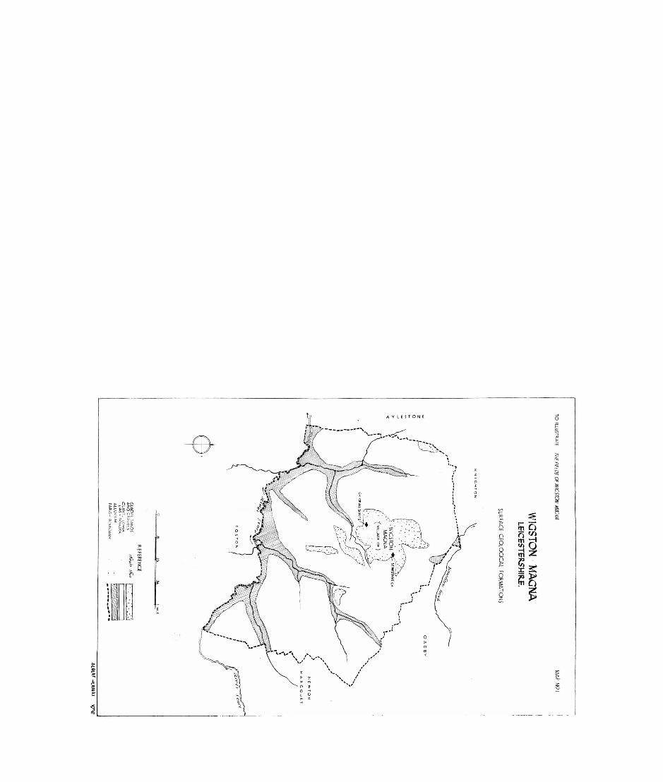
This ridge runs roughly east and west, though it is barely perceptible on the map. It is formed by a large patch of sands and gravels left behind by the retreating glaciers of the last Ice Age and rests upon the thick bed of boulder clay that covers the greater part of Leicestershire to the east of the Soar. Like nearly all the villages of eastern Leicestershire, Wigston was first founded upon this vital patch of sands and gravels, which provided a light, easily-worked soil, a dry and warm foundation for building, and a water-supply from the springs that bubble out where the gravel bed rests on the clay. This island of glacial sands and gravels would have been less densely wooded, too, than the boulder clays around, and was therefore easier to clear in the first place and to till afterwards.
The island, as we may call it, upon which Wigston was built, is larger than most of those upon which villages have been founded. Roughly rectangular in shape, it is about three-quarters of a mile from north to south and about half a mile from east to west (see Map I). There are two other patches to the south of the village, but though they were important for the springs to which they gave rise, they were not used for building and we may ignore them here. The large patch which became the site of the
as St. Wolstan's to-day. But there is clear evidence that the original dedication was to the Mercian saint, St. Wistan. This, however, is a point to which I must return in another article.
THE FIELDS OF WIGSTON MAGNA 165
village is about 290 acres in extent, perhaps a little more, so far as one can estimate from the map, and this would have sufficed for the first settlement, its buildings and its fields. Though the fields soon outgrew the limits of the sands and gravels and extended early in medieval times over the heavier clays, the village itself never spread beyond the limits but ended abruptly where the clays began. This abrupt line between the village and its fields is characteristic of Leicestershire villages; one goes suddenly from one to the other, and this is very marked at Wigston Magna. Usually the short lane that gives on to the fields is known as an "end". In Wigston we have Newgate End, Mowsley End, and Bushloe End, and the point where they terminate (or used to terminate) is almost exactly the edge of the sands and gravels. In medieval times, especially, the village must have been a compact little group of houses, perched on its slopes above the clay-lands, ringed around with a thorn fence or a balk of some sort, through which gates gave on to the great open fields. To-day, this ancient compact plan has usually been destroyed by the modern builder, whose buildings sprawl un tidily outwards along every road in a meaningless way.
Before we begin to speak of the fields of Wigston Magna, what do we know of the antiquity of the village ? Nothing of a Roman or a pre-Roman date has been found in or near it. 2 Its site must have been virgin forest even during the long Roman occupation, for it lay in the untouched country between the Fosse Way, which ran to the west of it, and the Gartree road, which ran to the east. Yet the road upon which Wigston stands is itself of great and unknown age, certainly older than the Romans, though it had fallen into disuse, in all probability, by Roman times. It is true that nothing of a pre-Roman date has been found along its length, and Peake, in discussing the pre historic roads of Leicestershire, neither mentions the road nor marks it on his map.3 Nor do parish boundaries follow the road, except for a short stretch between the eleventh and twelfth milestones from Leicester; and this is the most certain evidence of antiquity in a road, even if no other evidence is available.
2Except some small Roman remains in Kirkdale close, just outside, theWigston boundary, in Glen Parva parish,
sin Memorials of Old Leicestershire, ed. Dryden.

166 LEICESTERSHIRE ARCHAEOLOGICAL SOCIETY
Nevertheless,, we must allow a great age to the Welford road, and for this reason: it was in constant use early in medieval times as one of the two main roads between Northampton and Leicester and it was the more important of the two. On the Gough map (the earliest road-map we have for this country, dated some time in the first half of the fourteenth century), its course is clearly marked, while that of the Harborough road is indicated merely by the line of the chief villages. We know also that when Edward I moved northwards to Leicester, which he reached on December 6, 1300, he used the Welford road. 4 More over, this road was important enough to have a "broad stone bridge" where it crossed the Sence, a mile south of Wigston, as the Wyggeston Hospital records inform us as early as 1280- 92. 5 Clearly, then, the Welford road was one of the more important medieval roads, joining two considerable towns; and such roads were, almost without exception, based on tracks of even greater age which were taken over and improved upon. There was no road-making after the Norman Conquest; like the Anglo-Saxons, the Normans made use of tracks and 'ways that were ancient even to them. 6
The Welford road, then, is of pre-Roman date, though it may be no older than the Iron Age, for it has none of the characteristics of the ridge-ways, those oldest of all ways. It appears to be a road of the Hillside type, but that is all we can say of its probable age. For centuries it crossed the high ground to the south of Leicester and passed over the ridge where Wigston now stands. Roman life and business left it on one side.
About the year 500, however, the invading Angles crossed the low divide between the upper waters of the Welland and those of the Soar, and "the people of Peotla" founded their first settlement in Leicestershire—Peatling, not four miles south of Wigston. Soon afterwards they occupied the large and com-
"Stenton, Economic History Review, November 1936.5See Hamilton Thompson, Wyggeston Hospital Records (1933), Nos. 902,
903. These grants, dated some time between 1280 and 1292, mention "le Erodestanibrig" as somewhere in the township of Wigston, and I identify it as the bridge over the Sence, now called Kilby Bridge, as the only possible site in the parish which would have called for
• a stone bridge.sStenton, loc. cit.

THE FIELDS OF WIGSTON MAGNA 167
manding ridge of good land now called Wigston, probably in the first half of the sixth century, and similar sites to the east at Oadby and the west of Glen Parva. 7
Wigston's history, therefore, begins some fourteen hundred years back, though what its first name was we do not know and never shall know; for in its present form it is an Anglo-Scan dinavian name dating from the late ninth or early tenth century: "Vikingr's tun", so called after some Danish overlord. Perhaps the earlier village was destroyed in the fighting for Leicester about the year 868, and the new settlement given a new name when it was rebuilt.
Something, too, of its very early history may be deduced from the shape of the village. Indeed, the evidence of the map is often the finest evidence we have for this dark period when written records are few. Wigston Magna is a good example of the "ring-fence" type of village (see Map II). This was a roughly square, sometimes nearly circular, grouping of the village buildings, enclosing an open space, the whole village being ringed around by a fence as protection against sudden attack from the surrounding forest. At Wigston the shape is rect angular; four roads, lined with houses and cottages, enclose an open space of about forty acres. As for the ring-fence, many documents up to and including the enclosure award of 1766 speak of "the ring-fence of the town of Great Wigston", though doubtless it was but a legal fiction by this date. Perhaps it was represented in later times by "the common balke" or "the towne balke", which is frequently mentioned in seventeenth and eigh teenth century documents.
These ring-fence villages betray their origin by their shape. They were clearings in dense forest and they took this form from
TThe evidence for this statement is, of course, the large Anglian cemetery discovered at Wigston in 1795 (see Victoria County History of Leicester, I, 228-30 and Nichols, IV, 377). Some of the finds are dated as belonging to the latter part of the sixth century. The original settlement would probably be slightly earlier in date. The site of this cemetery is a matter of dispute, for though the Ordnance Survey 25-inch map marks it as where the Memorial Park now is, in the middle of the village, Throsby's letter to Nichols (loc. cit.) distinctly says that the ground sloped away from the site on all sides, that the site was not in the village but "near" it, and that "it is the highest ground thereabouts". This description, meagre though it is, makes it impossible for the Memorial Park (anciently the Gaol Close) to be the site.
168 LEICESTERSHIRE ARCHAEOLOGICAL SOCIETY
the beginning as the best defence against possible attack from any side. This "hollow square" method of defence was used, as we know, at Waterloo, when the British were being hard pressed; and later, when the American pioneers were pushing westward through territory inhabited by Red Indians, their chain of covered wagons formed a hollow square or circle when the feared attack came. Such a method of defence is therefore of great antiquity; we find it as far back as the sixth century, here at Wigston, when the pioneers who were making a new England were obliged to settle in unknown country with woods on all sides of them. To this day, the village of Wigston Magna keeps, essentially, its ancient shape, as do a few other Leicester shire villages, such as Great Dalby and Old Dalby.
II.We know almost nothing of the field system of the Anglo-
Saxons; only a few references to it have survived in early char ters. At Wigston, we do not hear of the village fields until the middle of the thirteenth century, though it is certain, of course, that they were in existence long before the Norman Conquest. From the middle of the thirteenth century onwards, however, we have as full an account of the medieval fields and their occupiers at Wigston as few villages in the country can show. Among the early records of the Wyggeston Hospital, transcribed by Professor Hamilton Thompson, no fewer than 209 refer to land in Wigston, ranging in date from c. 1170-80 to 1543; and after that date we have a great number of records which have been preserved at the church of All Saints, as well as the later records of the Wyggeston Hospital, which Professor Hamilton Thompson did not transcribe. The result is that few if any villages in the country possess so much information about their ancient fields, the men who tilled them, and the names they gave to every hillock, slope, spring, coppice, path and corner of their native parish. I have collected together all the field-names and other minor names in Wigston from the thirteenth to the eighteenth centuries; as many as possible have been deciphered and their original meaning disinterred; and occasionally I have been able, by walking over the fields of to-day with a six-inch map, to identify where these .ancient names were given, and for these I give the modern name also.

THE FIELDS OF WIGSTON MAGNA 169
The first land*to be tilled in Wigston would have been the forty acres or so that lay enclosed within the ring-fence. This land was light, easily worked, and it sloped away gently to the south. As we walk along the lanes that traverse this little space to-day, still mostly open and cultivated, we see land that has been tilled for fourteen centuries,
Classic monotony, that modes and wars I<eave undisturbed.
But these few acres would soon have proved inadequate, and rapidly the encircling forest would be pushed further and further back, and new land brought into use; at first, the sands and gravels around the village, then the heavier clays beyond and the long slopes towards the Sence and up towards the Old Mere, and away towards the two brooks on the westward edge of the parish. By the time of Domesday about seventeen ploughlands had been brought into use, together with fifty acres of meadow, still considerably less than half the total area of the parish.8 As we shall see shortly, however, most of the remainder appears to have been cleared and brought into cultivation by the early years of the fourteenth century.
From soon after the middle of the thirteenth century the Wyggeston Hospital records begin to give precise details of the fields of the township. Like Oadby, Wigston had three open arable fields at this date. The west field is first mentioned in a grant and confirmation dated December 20, 1269; the north field in a similar document dated July 8, 1271; and the east field in an undated grant, which is placed by Professor Hamilton Thompson as between 1280 and 1292. 9 These are the first occasions on which the three fields are mentioned specifically by name, but without doubt they had existed under the same names for some generations at least before this time.
exact number of ploughlands at Wigstou is not known, as Robert held of the Countess Judith two ploughlands all but two oxgangs in Oadby and Wigston. I have assumed that one plonghland of this was in Wigston. The size of the ploughland or carncate is a matter of great obscurity, but for reasons given later I suggest it was about 96 acres at Wigston. This would make the cultivated area at Wigston in 1086, including meadow, rather less than 1700 acres.
^Wyggeston Hospital Records, Nos. 884, 885, 886, and 901.

170 LEICESTERSHIRE ARCHAEOLOGICAL SOCIETY
111 the course of the fourteenth century, the north, east and west fields received more specific names, which, except for one change, they kept until the enclosure award of 1766 put a formal end to their existence; though the names lived on and were written in legal documents even into the nineteenth century, long after the old fields had been dismembered. In a long grant and confirmation dated March 1, 1392-3 the north field is described as "the fields towards Mokelow"; the west field is "the fields towards Twobrokes"; and the east field becomes "the fields towards Thythornhill". 10 Twobrokes field became at a later date, some time between the early 15th and the late 16th centuries, Goldhill Field; but Mucklow Field and Thythornhill Field remained unchanged from this time onwards.
An interesting point which we discover from these records is that the three medieval fields were named after some con spicuous point at their boundaries. Both Gold Hill and Ty- thorn Hill (as it is called to-day) He at the boundary of the parish, the one to the north-west, the other to the south-east. Mucklow ("the great hill"), though we cannot identify it for certain to-day, undoubtedly lay somewhere on another part of the boundary of the parish. We are justified in saying this, I think, by analogy from the grant of 1392-3, where all three fields are described as "towards" a certain point, which for two of them we know was on the boundary. If then we wish to iden tify the old Mokilho-iv (as it is first spelt in the document of 1280-92),n we must look for it somewhere on the other boundaries of the parish. We know in addition that it must have lain at or near the junction of the north and the .east fields, for, though the north field was afterwards known as the Mucklow Field, a grant and confirmation of 1280-92 speaks of Mokilhow as being in the east field also. The actual site of "the great hill" can be no other than the rising ground in the extreme eastern part of the parish, where it touches the Old Mere, and where the parishes of Oadby, Wigston, and Newton Harcourt all meet, at a height of nearly four hundred feet above sea-level. It is, indeed, the highest point in the whole of the parish of Wigston. The actual topmost point is just inside the Oadby boundary, just as the
No. 978.No. 901 (n.d. but placed by Hamilton Thompson between 1280
and 1292).

THE FIELDS OF WIGSTON MAGNA 17 I
highest point of TPythorn Hill is just inside the parish of New ton Harcourt; but all the rising ground up to the top would have- been given the name of Mokilow. Hence, too, the reason why part of the hill-slopes lay in the north field, and part in the east field, of Wigston. 12
Both Gold Hill and Tythorn Hill are marked on the six- inch map to-day, and need no identifying. The old "Two- brokes", somewhere at the edge of the west field, is difficult to identify to-day because the coming of the railway has altered the face of the country on that side of the parish; but the name almost certainly refers to the two streams which now meet just to the west of Wigston Magna station and flow south to join the Sence near Crow Mill Bridge.
From these records we discover, too, that by the latter part of the thirteenth century or the early years of the fourteenth, the fields of Wigston Magna were being tilled as far as the boundaries of the township. In 1280-92 two selions "upon Mokilhow" are mentioned; in 1305 we hear of "a rood upon Thythornhull"; while as early as 1272-3 land was being cultivated "at the foot of Goldhil". 13 By the early years of the fourteenth century, then, we may say that the fields of Wigston had expanded to the boundaries of the township, though there may have been small pieces of unreclaimed land within their limits.
Each of the three fields was perhaps a thousand acres in extent, even allowing for the meadows and common pasture. They were divided into strips, some known as selions and some as roods. An undated grant (some time between 1280 and 1292) tells us that twenty-seven acres contained 133J selions, which gives us the size of the selion as almost exactly one-fifth of an acre. 14 The same document also mentions that the twenty- seven acres made up Ij virgates, which makes the virgate at Wigston to be 22 acres, and the ploughland to be 88 acres.
121 have dealt fairly fully with this identification of Mokilhow, as an instance of how it is possible to piece together the existing frag ments of evidence, and so to re-discover the lost site of this old name. For some additional remarks on this name, see the list of Field and Minor Names that follows this essay.
"Docs. No. 890, 901, 924."Doc. No. 894. No. 924 (dated April 27, 1305) confirms this. From it
we learn that li roods were equivalent to 2 selions, which again gives 5 selions to an acre.

172 LEICESTERSHIRE ARCHAEOLOGICAL SOCIETY
Allowing for the balks and other waste pieces, however, which this grant does not, we probably have a virgate of 24 acres at Wigston, as at Cossington and Skeffington, 15 that is, a carucate or ploughland of 96 acres.
A considerable amount of land in Wigston was freehold, held in socage, and subject only to a chief rent to the lord of the manor, the remainder of the land being known as "bond-land". The freehold tenements of the 13th, 14th and 15th centuries, which appear so frequently in the Wyggeston Hospital records, are the lands of the Domesday sokemen, of whom there were thirty-one in 1086, out of a total enumerated population of eighty-six. It has been observed elsewhere that the presence of a considerable number of sokemen in a manor at the time of Domesday is one of the surest tests we have of Scandinavian influence. The Danish settlers of the ninth and tenth centuries, and their descendants, were relatively free men, in contrast to the native English, who show a high proportion of unfree or villein and cottager holdings, the bond-land of medieval Wigston. This contrast goes on into later centuries. Thus in 1630, accor ding to Nichols, there were no fewer than sixteen freeholders in Wigston, 16 most of whom were ordinary yeomen and husband men; while in Devonshire manors at the same date we rarely find more than three or four freeholders and they are not yeomen but are styled Gent, and Esquire: for there were few if any free men and sokemen in Devonshire at the time of Domesday, so that in later centuries the ordinary man still owns no land of his own. The small freeholder is characteristic of many Leicestershire parishes, and, broadly speaking, he has his origin far back in the Danish settlers of the late ninth and the early tenth century.
In Wigston we have traces of these Danish holders of land even in the thirteenth century, some three or four hundred years after their forebears had first come into this district. One of the earliest documents, probably before the middle of the thirteenth century, speaks of the virgate which Ketel held, and the half virgate once held by Turbertus or Thurbern. A little later we hear of Adam Toki, while Robert Camel's toft is mentioned as
15See Transactions of the Leicestershire Archaeological Society, vol, XVIII, Pt. II, 213, 246-7.
JSNichols, TV, 375.

THE FIELDS OF WIGSTON MAGNA 173
early as 1260-69 arM his descendant Richard Gamull occurs in a record dated 1516. Indeed, this is in all probability the Gamble family whose name is written in the first pages of the parish register late in the sixteenth century, and who continued to live here for many generations afterwards. All these are pure Danish personal names: Ketill, Thurbert, Toki, and Gamall. In addition we find a Richard Thorkyl, holding land "in Wode- gate" in 1306-8, who must have descended from a Thurketill of the tenth century; and we hear also for a time of a John Wykyng who, as I have suggested elsewhere, 17 may be a descendant of the original Vikingr who gave his name to Wigston.
Scandinavian names appear not infrequently in the names of the old fields and slopes. Gonewarhil or Gumvarhil was named after Gunnvor, a Scandinavian feminine name. The Old Norse eng, meaning "pasture or ( grassland", is found in Hountheng, which lay somewhere in the west field in 1272. Mikill, the Old Norse form for "great, large" is found in Mokil- how, already discussed; while the influence of Danish speech is seen in the frequent changing of the Anglo-Saxon ch to the hard Scandinavian fe sound. Thus "the thatchers' hill" becomes in Wigston ThakkerhiU or Thakkerhull.
Before we comment further on the names of the fields and of the other minor features of the landscape, we may say a little about the management of the fields. It is not necessary to describe the arrangement of the open field system, its multi tudinous strips, furlongs, lands and leys, its rotation of crops, and all those things that can be found in any more general work. But among the Wigston records we catch now and then some more personal and intimate glimpse of the past life of the village. In an old account-book of the Town Constables,18 two of whom were appointed every year, we get an occasional sidelight on the details of the management of the open fields. Every year the constables appointed, with the consent of their townsmen at a public meeting, a field-reeve, a pinder (to take charge of the village pinfold or pound) and occasionally an official crow- scarer. The duties of the field-reeve are described in a note
^Transactions of the Leicestershire Archaeological Society, vol. XIX,Pt. I. 7n.
^Preserved at All Saints' Churcli, Wigston Magna. The accounts coverthe period 1654-1714.
174 LEICESTERSHIRE ARCHAEOLOGICAL SOCIETY
made by the constables in 1703 "that Peter Ragg and Richard Davenport by and with ye Consent and advice of the Neighbours Did hire Matthew Holmes To keep the field, viz., to scare ye Crows from the time of earing untill the harvist is all ined and to kill all the Molds in the most seasonable times in the year and to Catch the Sparrows and destroy them in the Town as well as in the field for which Duty and service done he is to have The sum of 3 pounds a year and 2 shillings to buy him any powder begining from or at the 25th day of March 1703 and to be payd Quarterly".
A little later crow-scaring was made a distinct piece of work and we read of "gunpowder for ye Crow scarer 2/4". The field-reeve was helped in his task by village boys also, who caught sparrows, moles, hedgehogs, foxes and sometimes an old badger. In the year 1700-1, for example, the constables paid "To Boyes for Sparrows £1-8-4^". A dead hedgehog was worth threepence, foxes and badgers a shilling each, as the accounts show, and all the while the crow-scarer was mouching round the fields of growing corn and banging away at the crows with his old gun.
The ditching of the fields and "moweing Rushes in the field" were also necessary from time to time; the town wells needed a good deal of attention; the trough at the Horseweli, the ancient spring that had flowed out century after century near the green, had to be repaired now and then; and always there was work to be done on the bridges of the parish, whether they were solid stone bridges like Kilby Bridge or just planks laid over a brook, as at Newgate .Lane End. The door of the pinfold, just by the church of All Saints, wanted mending often, and less often the "Wash-pit", where the village housewives did their washing together, was cleaned out. All these things the constables had to attend to and get done, the expenses being met by a periodical levy of so many pence on every yardland.
Another document gives other details of the life of the parish at this time. A bond entered into by William Abbott of Wigston recites that "Whereas for the preventing and redressing of divers disorders and growing abuses which dayly happen and Arise in the Common and open fields of Great Wigston......Itwas mutually concluded condescended unto and fully Agreed upon by the above bounden William Abbott amongst others

THE FIELDS OF WIG3TON MAGNA 175
That John Horsepotle, John Noone, Henry White senr., George Boulter and Francis Johnson...... should make constitute andappoint such Order or orders or By laws as they thought to be meete and convenient for the Regulating and well ordering of the Common or open fields of Great Wigston aforesaid As well by Enlarging improving and Encreasing the Common or Grene- sword ground in the said fields as alsoe by any other wayes or meanes as to them. .....should seeme meete and expedient" andthese by-laws were put in writing "before 1 May, 1679". 19 Un fortunately, these by-laws for the proper management of the open fields of the parish, drawn up by" this little committee of villagers, are not to be found, and we are left with nothing but this passing reference to some old dispute.
In 1706-7 the Old Mere, which would have been a wide, grassy track, unhedged and taking up much valuable space, was apparently brought into use as part of the fields. But "it is agreed upon by nighbors before the mere was divided that no man shall either plow or dike any part of the mere". 20 It was to be left as pasturage and was to be equitably used by all who had rights of common. And every year, on Rogation Monday, the Wigston church-wardens, with some of the parishioners, made a holiday and with spades cleaned out the large holes along the middle of the mere which marked the exact boundary between the parishes of Newton Harcourt and Wigston Magna. This ceremony on Rogation Monday was still carried out within living memory, and the boundary holes were to be seen in recent years. 21 It goes back considerably further than the dividing of the mere, for as far back as 1621 the church-wardens' accounts record "Spent on Rogation Monday 2/0." By the 1820's this Rogation meeting, as it was called, had become a more expensive business. The bread, cheese and beer consumed by the followers of the church-wardens cost between three and four pounds every year.
Another aspect of the old fields was the early enclosure, here and there, of small parcels of meadow and arable land, the latter nearly always abutting upon the homesteads of the
Documents, No. 148 (Leicester City Museum). 2°Constables' Accounts, loc. clt.21Ex inf. Mr. E. S. Boulter, whose family have lived in Wigston for four
hundred years.

176 LEICESTERSHIRE ARCHAEOLOGICAL SOCIETY
village. The freeholders must have effected exchanges of some of their strips with each other, in order to bring as many as possible together in one compact block. Thus in an early 14th- century document we read of a messuaga in Wigston and "seven selions abutting on the said messuage",22 which can only mean that these seven strips had been brought into a single block and would shortly be hedged about and separated from the common arable field. By the middle of the fifteenth century he hear of several other closes, such as Swetyng's croft, Redlys croft, Randulls croft, and Halcroft; at the end of the sixteenth century others are mentioned in the church-wardens' accounts (New close, Balldike close, Stephen Astill's close, Hall close). 23 Other closes came into existence in the seventeenth century, but all were small, rarely more than a couple of acres in extent, some times only an acre. The seven selions mentioned above would have amounted to less than one and a half acres, and would have formed a typical close. Altogether there were a considerable number of such ancient closes in existence by the time the open fields as a whole came to be enclosed by the award of 1766. They nearly all lay behind the homesteads and "within the ring fence of the town of Great Wigston", but altogether they could hardly have amounted to fifty, at the most a hundred, acres.
The three fields of the parish stretched to the farthest limits of the parish. Each was separated from the others by old foot-paths, streams, and hedges of tangled thorn and ash; and along the entire Aylestone side, where there was no natural boundary such as the river or the wide trackway of the Mere, there was a mounded fence between the townships which was still to be seen of recent years. The enclosure award of 1766 speaks of a gate in "the antient fence" between Wigston and Aylestone.
As for the boundaries of the three fields within the parish, we do not know for certain exactly where they ran, though we can get a fairly accurate idea from the numerous grants, conveyances and leases throughout these centuries. Roughly speaking, Mucklow Field occupied all the land to the north of the village, Goldhill Field all to the west, and Thy thorn hill Field all to tlis
zzWyggesion Hospital Records, doc. No. 945. "Nichols, IV, 885. (Church-wardens' accounts, 1591).

THE FIELDS OF WIGSTON MAGNA 177
east. More precisely, Mucklow Field was to the north of a line from Aylestone Lane, along Bell Street, and up Church Nook; and thence across to the Newton road which was the boundary between Mucklow Field and Thythorn hill Field. Some part of Goldhill Field lay to the north of Aylestone Lane, however, for the enclosure award mentions the ancient fence between Goldhill and Mucklow Fields as crossing the lane a little to the west of the village, while land adjacent to Balldike close, which faced down Bell Street, was in Mucklow Field.
The approximate boundary between Thythorn hill Field and Mucklow Field was, as has been said, the footpath to Newton for some of its course. Where such ancient well-defined paths served as a boundary probably no fence was necessary between the fields. Only where the boundary went across country with no clear landmarks was a mounded fence required.
Gold hill and Thythorn hill Fields met at the Green, the- level space at the foot of Bullhead Street, which was probably the boundary northwards to the Bank. The latter, a wide space at the north-eastern angle of the rectangular street-plan, was in all probability the meeting place of the three fields. South wards, Horsewell Lane seems to have been the boundary between Goldhill Field and Thythorn hill Field, with its continuation in the footpath to Foston. A lease of 1704 informs us that "one ley upon Tofts", in Thythorn hill Field, abutted into Foston Gate. But further south the boundary diverged from this path and ran, apparently, to Kilby Bridge, the southernmost limit of the parish.
The three fields being so large it was necessary to give names to every hillock, slope, spring, copse, and other land-mark within their bounds. Few of the names in the long list which follows this essay are those of actual fields or closes; most are given to natural objects, and served to identify them and to give directions before the days of hedged and divided fields and signposted roads. Some of the names so given were personal names, after some owner or occupier, and these are the least permanent of all the minor names of the parish. "Gunnvor's hill", for instance, soon disappeared as a name, and so, too, did such names as "Alger's toft", "Becke tenement", and "Gnes- clin's field". Most of the early closes received other names when they changed owners, though a few, such as Balldike close and
178 LEICESTERSHIRE ARCHAEOLOGICAL SOCIETY
Stockhill Holm close, preserved the old name in a more or less recognisable form.
Generally speaking, the more permanent names are those given for some natural characteristic such as the quality of the soil or the lie of the land rather than those called after a particular owner. Springs, especially, were named early, and their names were most permanent of all, as we should expect. Among these we have "the foul spring", "the cold spring" (though this occurs only once), "the horse spring", "the black spring", "the holy spring", and "the spring in the copse" (Wellespring). Two of these can be found to-day. "The horse spring" still flows copiously into its trough and could water horses to-day; and "the black spring", far out over the1 eastern slopes of the parish, still bubbles out of the earth by the Glen footpath, into a reedy pool that is dark even on a sunny April afternoon. We see it to-day exactly as it welled out seven hundred years and more ago, just as the villein of the thirteenth century saw it when he gave its name to the remote fields that slope down to it from either side.
The topography of the fields naturally suggested many names. Early settlers, and their descendants into medieval times at least, were sensitive to the slightest rise and fall in the level of the ground, and gave many names to hills that we. having nearly lost the practice of walking in fields, would not perceive. In Wigston each of the long slopes of the rolling clay-land had its name, as did each minute stream that flowed in the hollows. Most of these slopes cannot be detected even on the six-inch man: one must walk over the ground itself to see them. Thus "Water mill hill", where South Wigston now is, was not thirty feet above the river-meadows; Newgate hill, rising southwards from the brook that bounds Newgate End. is not much higher, nor are most of the slopes that were given the title of "hill" in medieval times. Other topographical names in Wigston are Flatt close, Little Hill, Little Dale, Halterslade ("the hidden slade"), Hilly meadow, Long meadow, Broad meadow, Mucklow, Bushloe, Two brooks, "the hanging slope" (le Hanggand in 1395), "the shining pool" (Sherpol), and the lost "copse with much thicket" (Wrthegraue or Wortegraiue).
Then we have "gold hill" and "golden meadow", from the gorse on the one and the buttercups in the other; the "thick

THE FIELDS OF WIGSTON MAGNA 179
thorn hill" where the flowering thorn drew dense; and another "hawthorn hill" somewhere in the west field. Moseho, a fifteenth century street in Wigston, was "the mossy or boggy hill"; in Radegres grew the reedy grass that suggested the name of this corner of the fields; on Taselhill teasels grew in the fourteenth century, and on Thakkerhill, probably, grew the reeds that the thatcher looked for.
Some quality of the soil frequently suggested a name. In Wigston we have "black earth" (Blakemilde), "the dunged land" (Cakeforlong and Muckeland), "the clayey sike" (Cley- sike), "the hungry ground" of Hungerton hill, "the moory field" (Moriwong), "the stony pastures" (Stoney leyes) and "the watery pastures (Watry leyes). Crops are mentioned in Neprodes ("clearing for turnips") and Hecroft ("hay croft"); grassland is distinguished from arable in several ways (e.g., Anchor close, Grescroft and Hountheng).
Animals and birds, too, helped to name the lesser features of the landscape. In Wigston, as in several other parishes, there was a "badgers' hill", and, more uncommon, "wolf hill". We have also "calves' pasture" (Caluerelewese), "the holm fre quented by geese" (Goseholm) and "Lambs' shelters" (Lambe- cotes).
But it is perhaps the names taken from the wild birds that carry us back most surely to these medieval fields: the crows that gathered round the water-mill on the Sence, so that it became known later as Crow mill: the great hawk that for a brief space gave his name to le Hauken.de, some part of the village where he hovered; the cranes that frequented the pastures of Carnlese in ancient sunlight, after fishing in the shining pool; and, more than any of these, the buzzards that wheeled above Boyteresike,
On great pied motionless moth-wings borne alongSo effortless and so strong.
Over some hollow remote from the village the buzzards soared all day, and some tired cottager, returning at evening from his outermost furrows, would have seen them, still climbing and falling, above the darkening stream.

l8o LEICESTERSHIRE ARCHAEOLOGICAL SOCIETY
III.
FIELD AND MINOR NAMES OF WIGSTON MAGNA.IN the following list of all the field and other minor names that occur in Wigston Magna between the thirteenth and the eigh teenth centuries, the various forms of the name are given, together with the dates at which they occur. The meaning is then given, where it can be deciphered (for a single reference is often of no use in deciding upon the meaning of a name); and the position of the field or whatever object is named is then given, if it is known, together with any other information that is felt to be of interest. The following abbreviations are used: O.E. for Old English, M.E. for Middle English, and O.N. for Old Norse. Doc. refers to the Wyggeston Hospital Records (Hamilton Thompson).
Ailistonmere (1348). "The Aylestone boundary" of Wigston, on the west. Mere is from the O.E. (ge)nuzre, boundary. Cf. Old Mere, below.
Algerystoft (1348). Probably "Alger's toft", Alger being a medieval surname. A toft was originally the homestead, as opposed to croft, which was the land attached; but came later to be used of a piece of land generally. In Wigston it is "the lane called Algerystoft", so called because it led to Alger's holding. This is the only reference, however, to the lane or the toft.
Anchor Close (1766). Referred to as an "ancient close" in the enclosure award of 1766. The absence of any other refer ence, especially an earlier one, makes it difficult to give a meaning. It must be derived, however, from the O.E. anger, meaning "grass-land", as opposed to arable land or forest. Anchor close lies on the west side of Horsewell I/ane and the south side of Moat Street.
Balldyke close (1591), Balldike close (1766). Balldike is called "a certain antient lane or place" in the enclosure award. The close, which faced down what is now Bell Street (formerly Balldike Street), dates perhaps from the sixteenth century. The name is derived from the Balls, who were a considerable family in Wigston in the 13th and 14th centuries. Hence "Ball's ditch".

THE FIELDS OF WIGSTON MAGNA l8l
Balldike street (1766). Now Bell Street. The name was probably changed about the end of the 18th century, when the Blue Bell was a flourishing coaching inn on the road to Welford and Northampton. This inn stood where Shipp's, the draper's, now is, but went out of existence about 1846-48.
Bear pitt (1709). Perhaps "the bear pit", though it was some distance from the village, being near Long Meadow which lay by the Sence.
Becke tenement (1338). So called from John Becke, who held land in Wigston between 1247 and 1260.
Blabygathe (1247-60). "The way to Blaby".Blacwellesike (1280-1218), Blac-welsick (1280-92), Blagwelle-
syke (1280-92), Blak-welsike (1393), Blakwellesike (1393), and Blac-wellsikenezirend (1347). "The Sike or marshy ground by the black spring". As to its situation, doc. No. 926 (1306-8) speaks of "one selion without Blacwellesike, next the boundary of Outheby". This enables us to find the exact site to-day, for about one mile along the old footpath to Glen a stream rises in a well-marked dip in the ground. The bottom of the hollow is marshy; the stream rises in a dark spring which bubbles out a few yards to the south of the footpath. The dark ness of the spring and the little pool into which it falls is, of course, due to the colour of the earth here (cf. Blakemilde, below). Black-spring-sifee was a long, narrow piece of land: hence it was divided into an upper and a lower end (nezirend, nether end), the latter abutting on to the Newton road, about one-third of a mile away. See also Glensick, below. Note that "well" is usually to be interpreted as "spring", and not "well".
Blakemilde (1280-92), Blakemylde (1305), Blakemyld (1376). "Black earth", from the O.E. mylde, mould, earth. So called from the colour of the soil. Its situation is unknown, and the name does not appear after the 14th century.
Boyteresike (1280-92), Boyte.rsike (1280-92), Boytersike- euerende (1306-8), Boydersike (1393), Beuter sick furlonge (1639). Boyter is an obsolete word for a bird of prey, probably a buzzard. This is therefore "buzzards' sike". This piece of land lay some where in the north, or Mucklow field, but its situation cannot be described more precisely than that.

182. LEICESTERSHIRE ARCHAEOLOGICAL SOCIETY
Brademedwe (1306-8), Bradmedou (1342), Bradmedow (1412), Erode meado-we (1639), Broad meadow (1704-66). "Broad meadow". This meadow lay along the Sence, probably a continuation of Long Meadow, q.v.
Bridge meadow (1766). Lay close to the present Crow Mill Bridge. It is not heard of before the enclosure award, but pro bably had existed under another name.
Brelterhul (1280-92), Bretthul (1347), Bretterhill (1393). There was a family of long standing in Wigston called Brett, but the forms make it difficult to assume "Brett's hill". The hill was in the north, or Mucklow field.
Broad greene pasture (1639). Self-explanatory. This lay in Goldhill Field, abutting on Water mill hill. The water mill can be none other than Crow Mill on the Sence (q.v.), and the hill can only be the slightly rising ground by the present South Wigston station.
Brochilslade (1273), Brockelislade ouereende (1273), Broc- hulslade (1280-92), Brokhulslade (1306-8), Brokkeslade (1393), Brokslade (1417), Brockslade (1639), Brookeslade (1704), Brooke Slade (1709), Brock Slade Baulk (1736). It is difficult to be cer tain whether the first element in this ancient name is the O.E. Brdc, brook, or the O.E. brace, badger. Perhaps the latter is indicated, as the second element, which is later dropped, is "hill" Slade is from the O.E. slced, low flat valley; but it has the dialect meaning of "a breadth of green sward in ploughed land". The full meaning is therefore "badgers' hill slade". It was situated in the east or Thythorn Field, and probably between the Newton Harcourt road and Spring Lodge, where there is rising ground.
(Middle) Brokenbacks (1709). This curious field-name occurs late and only once. It was somewhere in the east or Thythorn Field and is obviously a name of the nickname variety. Probably a reference to the stubborn nature of the clay-land at that spot. (Cf. Great Breakback, in a Warwickshire parish).
Bulgerishauidlond (1273), Bulgereshauedlond (1280-92), Beggars hadland (1704), Beggar Hadland (1709). Another curious name, but lacking any forms between the 13th and the 18th century. In its original form it refers clearly to "the
THE FIELDS OF WIGSTON MAGNA 183
Bulgar's headlanif", but it is difficult to imagine Bulgarians in medieval Wigston. Probably the term referred more generally to a heretic.
Bullhead Street (1766). So called from the Bull's Head Inn, which is probably of considerable age.
Bushloe End (to-day), Bussclow, Busscloive (1455), Bushloe House (1704), Busloe Toivnes End (1705), Bushley End (1766). Originally "the King's way called Bussclow", it is the oldest existing street-name in Wigston. From the O.E. bysc, bush, thicket, and O.E. hlaw, hill, low. Hence "the hill with the thicket". As the ground here is fairly level the reference to a hill may indicate a burial mound, 'i.e., an artificial hill. The editors of the English Place-Name Society note that "Grundy says that in the charters it always denotes a tumulus", though they think the term may be of wider application. At Wigston however, there is no hill where Bushloe End now is. The refer ence may therefore be to a tumulus.
(le) Puttes (1405). Doc. No. 986 speaks of "the common green called le Buttes". Self-explanatory. There is still a Butt Close beside the site of the old green, at the bottom of Bullhead Street.
Cakeforlong (1306-8). From the O.E. cue, dung; dialect word cock. Hence "the dunged furlong". Cf. Muckeland. below.
Caldeivelle (1306-8). "The cold spring".Calpit (1393), Coale pitt way (1709), Colebiti -way (1736),
Colepitt Way (1744). Probably "the charcoal pit" is meant here, in view of the early date of the first reference. Somewhere in Goldhill Field.
Caluerele-wese (1280-92). O.E. Ices, pasture, meadow-land, leys, and O.E. calf, cealf, calf. "The calves' meadow".
Cappehauitland (1247-60), Qippehundlad (1247-60). The second element is "headland"; the first unknown. Perhaps cap, chief.
Carnlese (1305). Perhaps from the O.E. crow, cran, crane. "Crane's meadow or pasture". It is hardly likely to be derived from O.E. corn, corn.

184 LEICESTERSHIRE ARCHAEOLOGICAL SOCIETY
Can Ban fee (1709, 1744). Probably identical with le Kerres- hcued (1306-8), from O.N. kiarr, marsh, low-lying ground. The original form would have meant "the headland of the marsh". Carr Bank was in the Mucklow Field.
Church corner (1709), Church nook (1766). Called Church Nook to-day, the dead-end by St. Wolstan's church, and formerly the footpath to Oadby.
Cleyhilsike (1273), Cleyelesike (1280-92), Cleylesike (1306-8), Cleysike (1393). Originally "clay-hill sike", the marshy ground or gulley by the clay hill. Later "the clayey and marshy ground". This lay in the east or Thythorn Field and was probably at or near the old clay-pit just to the N.E. of Kilby Bridge.
Cobaldeswong (1306-8), Kobaldeswong (1348). Wong is a fairly common field-name element, derived originally from the O.N. -vangr, a cultivated field. But it seems to have become a part of Midland dialect and is no test of purely Scandinavian settlement. The first element seems to be a medieval surname, the origin of our Cobbold. "Cobald's field".
Cokkesyert (1393). "Cokk's enclosure", from the O.E- gear A, enclosure, yard. The Cooks (Coc, Cokk, etc.), were an ancient family in Wigston. Henry Coc is a witness to a grant c. 1250. Perhaps Cockpitts leyes (1704) is a corruption of Cokkes yert, though it may represent a genuine cock-pit.
Crow Bridge (1685-6), Croobridg (1686-7), Crowbridge (1766), Crow Mill Bridge (to-day). Perhaps named after Cro-we- •well (1395), "the crow spring". A bridge frequented by crows.
Croivhill close (1766). An "ancient enclosure" in the award of 1766. It lay close to the bridge over the Sence; there is no semblance of a hill here, and we are safe in saying that the name is a corruption of Cro-we-well, above.
Cro-u< Mill (1766). A water-mill on the Sence. It is pro bably the water mill mentioned in a grant and confirmation of Feb. 24, 1347-8 (doc. No. 955), for the Sence is the only stream in the parish that could drive such a mill.
Croioson's close (1766). An "ancient enclosure" in the award. Probably of early 17th century origin, when the Crow- sons appear in the parish registers. The close lay near Newgate Lane End.

THE FIELDS OF WIGSTON MAGNA 185
Eyl (1247-60)f Heyl (1247-60), Eyel (1306-8, 1324-48), Eyle (1393), Oyle hillside (1709), Oile Hill Side (1744). This is a puzzling name. The various references make it clear that it was a prominent hill somewhere in the east or Thythorn Field, for we hear frequently of "upon Eyl" and "under Eyl". It was perhaps the high ground between the Newton Harcourt road and the present Tythorn Lodge, which is a prominent slope as seen from the village. As for its meaning, one can only suggest it may derive from the M.E. eile, a point, a bit of straw, an ear of corn. The New English Dictionary gives ail, for which the Dialect Dictionary gives the variant oil, which suits the forms we have here. The meaning is, however, "beard of barley", and it is difficult to associate this in any way with a prominent hill. It might possibly have been a hill noted for its fine yield of barley.
Faucow Sty (1309), Faukeslond (1443), Fawke's meadow close (1624), Faux close (1766). John Faucous [Fawkes] is mentioned in the 1327 subsidy for Wigston. Sty is used gener ally in the sense of a pen or an enclosed space. Hence "Fawke's close". The close lay adjacent to the village.
Flatt close (1766). An ancient enclosure near Horsewell Lane, so called because it lay in the flat piece at the bottom of Bullhead Street.
Fostengate (1393), Foston Gate (1704). "The way to Foston". Derived from the O.N. gata, road, way. The fre quent use of gate in this sense in Wigston is further evidence of the strong Danish influence on the minor names of this district. Nearly all the paths and roads leading from Wigston in medieval times were called gate, e.g., Blabygate, Glengate, Oadbygate, and so on. This path to Foston was probably the boundary between Goldhill Field and Thythorn Field, for at least part of its length. It still exists to-day as a broad, sometimes raised, grass-track. It crossed the Sence at the boundary of the parish by "an antient Foot plank", as the enclosure award (1766) tells us.
Foureslade (1324), Foure slade (1393), Power slade (1639). This can only be from the M.E. feower, four. "Four slades". This was in Goldhill Field.
Fowrsladegate (1348). "The way to Foureslade".
186 LEICESTERSHIRE ARCHAEOLOGICAL SOCIETY
Fulpitt (1321), Folepit (1280-92), Folepyth (1292). From the O.E. ful, foul dirty and O.E. pytt, M.E. pitte, pit, grave. Hence "the foul pit". This was close to Kilby Bridge and probably refers to the dirty water-logged land in the hollow ("pit") by the Sence.
Fulleivelle (1393), F view elle gate (1273), Folewellegate (1280-92), Full-well Head (1705 onwards), Fill-well Willowes (1731). "The foul or dirty spring". Somewhere in the west or Goldhill Field. Folewellegale was the path to the spring, Ful-well Head was the headland near it.
Gaol close (late 17th cent, onwards). So called because during the civil wars the prisoners from Leicester gaol were brought here for safety. Now the Memorial Park.
Gesselinis-wong (1306-8). O.N. vangr, field, cultivated land, From the medieval surname, "Guesclin's field".
Glen gate (1280-92), Glengat H347), Glengate (1395), Glenngate (1639), Glenn Gate (1731). "The path to Glen (Magna)". This path is still in use, running from St. Wolstan's church eastward to the Old Mere.
Glen Lane (1766). The road to Glen Parva.Glensicke planke (1686-7), Glenn Sick (1709). "The sike
or marshy ground towards Glen HVIagna)". The "planke", repaired in 1686-7 by George Oswin (Constables' Accounts) was a plank bridge but its exact site is unknown; it was in Thy- thorn Field. Glen sike was perhaps a later name for Blacwell sike.
Gold Hill (to-day). Goldehil (1273), Goldhulfot (1280-92), Golde-zvhel (1348), Goldewele (1393), Gouldhitt (1639), Gould Hill (1709), Gold Hill (1731, 1766). "The golden hill", so called perhaps from its carpet of gorse or buttercups. The hill lies on the western boundary of the parish and is but a slight eminence of sands and gravels which occur here as an isolated patch. It gave its name to the west field of the township. Goldhulfot is 'the foot of Gold Hill".
Goldene mediae (1324). "Golden meadow", probably so called from its profusion of buttercups.
Goneivarehil (1269), Gomvarhull (1342), Gunwarhill (1417). "Gunnvor's hill", an O.N. feminine personal name. In the west or Goldhill Field.
THE FIELDS OF WIGSTON MAGNA 187
(le) Gore (12S9-92), the Gore (1298). O.K. gam, a wedge- shaped piece of land.
Goseholm (1306-8). From the O.K. gos, goose, and the O.N. holmr, holmi, a holm, used locally of "a piece of low-lying ground by a river or stream". Hence the meaning is "the helm frequented by geese". This lay beside the Sence, as we are told in doc. No. 926 that part of Broad Meadow abutted upon it.
the Green (1766). Called "the common green" in 1405. This lay at the bottom of Bullhead Street and was an open space until the 1860's.
(le) Grenegate (1306-8). "The green (or grass-covered) way". Its location is unknown.
(le) Grescroft (1306-8). From the O.K. grass, grass. Hence "the grassy croft". It lay near Kilby Bridge.
the Gripps (1709, 1761). The late reference is an obstacle, but it seems fairly safe to derive this from the M.E. grip, furrow, ditch. Hence "The furrows or the ditches". This was in Thythorn Field.
Halcroft (1443), Hall close (1591). "The hall croft or close". This small enclosure lay next to the old Hall. Doc. No. 1023 says "a croft called Halcroft, lying between the tene ment of the lord of Oxford and the messuage of Richard Randull".
Haltereslade (1319), Halterslade (1324), Halterslade (1393;, Halter Slade (1639, 1731). From the O.K. heolstor, hiding- place. Hence "the hidden slade or piece of greensward". It lay somewhere on the far side of Thythorn Field, near the Sence meadows.
(le) Hanggand (1392). "The side of a hill", i.e., a hanging slope. Cf. the Hampshire hangers.
lie) Haukende (1306-8). "The hawk end", i.e.,, the end ofthe village frequented by hawks. The name never reappears,as we should expect, for it is clearly only a temporary name.
• Once the hawks had left this site, it would be given anothername.

188 LEICESTERSHIRE ARCHAEOLOGICAL SOCIETY
Hanthernehil (1280-92), Hawethornhul (1306-8), Hawe- thornhill (1395, 1417). "Hawthorn hill". In the west or Gold- hill Field.
Hcnvborn Bridg (1686-7). Probably the same root as Orebornhul (1306-8). The meaning is uncertain.
Hecroft (1247-60). May be either O.E. heah, high: "the high, or chief, croft", or more probably O.E. heg, hleg, hay: "the hay croft".
Herburgh hull (1376). Difficult to decipher with only a single reference, but it seems to go back without much doubt to the O.N. herebergi, herebyrgi, meaning quarters, lodgings. In M.E. this comes to mean an inn. Hence the meaning here is "Inn hill", but which of the existing inns, if any, is referred to is not certain. It would suit the situation of the Bull's Head, which is on the long slope up to the Bank in Wigston, and also would have been on the important medieval road to Northamp ton. The Bull's Head is an ancient inn and may well be on the site of an even older inn such as is commemorated in the name Het burgh hull.
Hillymedou (1342), HulKmedwe (1306-8), Hyllymedowe (1393), Hilly Meadowe (1639), Hillow meadow (1766). Self- explanatory. It was divided from Goldhill Field by a brook, most probably the brook which flows south to join the Sence to the east of Crow Mill. The meadow would have been between the present railway stations of Wigston Magna and South Wigston, in all probability.
Hilly meadow close (1766). Self-explanatory.Holywell (1417), Holywell Close (1709), Hoi-well close (1766).
"Holy spring". This was in the north or Mucklow Field, but what gave the spring this name we do not know. It was, per haps, associated in some way with St. Wistan's church (now called St. Wolstan's).
Horswelle (1348), Horsewell (1685-6), Horsewell close (1766). "The spring at which horses could drink". This copious spring still flows into a trough some 250 yards down Horsewell L.ane. There are references to the repair of the trough in the 17th cen tury Constables' Accounts. Horsewell close, an ancient close in the award, is adjacent to the spring.

THE FIELDS OF WIGSTON MAGNA 189
Hountheng (12M), Houndheng (1280-92), Houndyng (1393). From the O.N. eng, pasture, grassland. "Hounds' meadow", i.e., the meadow frequented by dogs. In the west or Goldhill Field.
Hociangathe (1247-60), Hmitonegate (1273), Houttone gate (1280-92), Houctongate (1280-92), Hoivtengate (1348), Hoghton- gate (1395). "The way to Houghton".
Hungertonhill (1280-92), Hungertonhull (1305), Hongerton- hill (1306-8), Hungirtonhull (1342, 1376), Hungertonhill (1393), "Hungerton hill". Cf. the place-name Hungerton, eight miles away, "the hungry farm", from the O.K. hunger, hunger, denoting poor and "hungry" land. The connection of this hill in Wigston with a village eight miles away is not clear, and it is difficult to see how the form Hungerton can have arisen inde pendently. The hill lay in the north or Mucklow Field
Hungertonesike (1280-92), Hungeitonesikeouerende (1306- 8), Hungertonsike (1393). "Hungerton sike". Cf. Hungerton hill above. All the Wigston sikes seem to have been long nar row strips of ground, bordering a stream, so that it was necessary to divide them into "the upper end" (ouerende) and "the lower end" (nezirende or netherende). We know that Hungertonsike was in the Mucklow Field, and we know it lay towards the Oadby boundary, judging by the arrangement of the selions and roods listed in a long grant and confirmation of 1393. The six-inch Ordnance Survey map reveals that two streams rise in this part of the parish; the western one we have identified as Blac-wellesike, It is almost certain that the other is Hungerton sike, and that the higher ground between these two dips was Hungerton hill.
(le) Kerresheued (1306-8). See Carr Banke above.Kilby Bridge (to-day). Kilbybridge (1685-6), Kilby bridge
(1766). Almost certainly the Stanbrig of 1280-92 and onwards, q.v.
Kylebygate (1306-8), Kylbygaie (1395), Kylby gate (1417), Kilbygate (1639), Kilby Gate (1731). "The path or road to Kilby", now the main Welford road.
Kills (1736). Obscure. This single reference is too late to allow any suggestion as to its meaning.

190 LEICESTERSHIRE ARCHAEOLOGICAL SOCIETY
Kirkdale Meer (1709). "Kirkdale boundary". Kirkdale close lies in Glen Parva, just outside the Wigston boundary, close to the Sence. We do not know what church is commemo rated in this name. The site is an ancient one, for some small Roman remains have been found in this close, and it lies near the. pre-Roman road which comes from south Leicestershire through Countesthorpe to Saffron Lane and so into Leicester.
Lambecotes (1306-8, 1393, 1395). From O.E. Lamb, lamb, and O.E. cot(e), cot, cottage, and more generally a shelter. Hence "lambs' shelter". Cf. Sapcote (Leics.), "shelter for sheep". Lambecotes was in Goldhill Field.
Lamas close (1709). A common element in field-names, from the custom whereby land cultivated in severally until Lammas-tide became common pasture from that date until the following spring. In Mucklow Field.
Lesemylde (1393). —lese is usually from the O.E. Ices, pas ture, leys but in conjunction with —mylde ("mould, earth") hardly seems feasible. No other derivation is possible, how ever. Lesemylde was in Goldhill Field.
Luttledale (1306-8), LMeldale (1308,1393), Little Dale (1639), Liiile Dale Flatt (1731). Self-explanatory. In Goldhill Field.
Little Hill (1766), or the Green. See Smalehulles.Long closes (1766). Ancient closes in the enclosure award.Long lane stile (1705-6), Long Street (1766). It is fairly
certain that Long Street was identical with the Long Lane of the early 18th century. Self-explanatory.
LongemedoTve (1305), Longe meadoive (1639), Long Meadow (1766). Self-explanatory. These meadows lay along the northern bank of the Sence, a continuation of Broad Meadow.
Long meadow close (1709, 1766). An ancient close of meadow.
Mabloive felde (1417). For a time the north field was so called, but soon after this date became Mucklow Field and remained so. Mablowe is probably "Mabile's hill", the Mabiles being an early medieval family in Wigston (see docs. 876-924, passim).
the Meer. See Old Meer.

THE FIELDS OF WIGSTON MAGNA 191
(le) Mori-wong (1273), Moriwong' (1280-92). "The moory field".
Moseho (1443). The reference is to "the street of Moseho in the town of Wykengeston". The second element is the O.K. hoh, projecting ridge of land, a promontory, a hill. The first element is perhaps the O.E. mos, moss, bog. Hence "the mossy or boggy hill". It is impossible to know which of the present streets is«to be identified with Moseho, biit it may be Bullhead street or Moat Street. Both these streets are on an incline, and of the two Bullhead Street is the more probable site, for it is on the main Leicester—Northampton road and is undoubtedly a more ancient street than Moat Street.
Moulds pen (1704). The Moulds or Molds were a well- known family in Wigston from the 16th to the 18th centuries. The pen would be a small enclosure, perhaps a cattlefold or a sheep-fold.
Muck eland (1639). Probably the "mucked or manured land". In the north or Mucklow Field.
Mucklo-w Field. Mokilhow (1280-92), Mokelow (1393), Muck-
lo-we (1639), Muckloe (1704, 1736, 1799), Mucklow (1731, 1766). Derived from the O.N. mikill, great, large, and O.E. hlaw, hill, mound (especially a burial mound or tumulus). The site of "the great hill" is discussed in the preceding essay on the Fields of Wigston. It can be identified with almost complete certainty as the high ground at the Old Mere, where the parishes of Wig ston, Oadby, and Newton Harcourt meet. Both Grundy and Ekwall consider that Maw, as used in old charters, indicates a burial-mound rather than a natural hill (cf. Bushloe, above}. This would be very likely at Mokilho-w, lying as it does within a few yards of an undoubtedly pre-Roman road. Moreover, the fact that three parishes meet here is itself suspicious, for a prominent barrow or tumulus always made an admirable boundary-mark. There cannot be much doubt that hla-w here denotes a burial-mound. Hence the proper meaning of the name is "the great barrow". Once more we see how ancient barrows, which have survived more or less untouched in open downland country, have been ploughed out of existence in lower-lying arable country. The marked absence of barrows in

192 LEICESTERSHIRE ARCHAEOLOGICAL SOCIETY
Leicestershire must be due in no small measure to this later cultivation of the soil.
Nare meadow (1639), Narr meadowe furlonge (1639), Near Meadow (1761). "The near meadow", in Mucklow Field.
Neprotis (1273), Neprodes (1280-92), Nepcrotes (1417). The form of 1280-92 leaves no doubt that we have here the O.E. ncep, turnip, and O.E. rod, clearing. Hence "the clearing for tur nips". This was in Goldhill Field.
Neu> Close (1591, 1709-10), New close meadow (1766). Self- explanatory.
Neugate (1347, 1393), New gate lain end (1686-7), Newgale End (1766). "The new way". This lay in Goldhill Field, and is called Newgate End to-day. The older way to Foston and Countesthorpe from the village was along Horsewell Lane.
Neu'gate Hill (1731). This is the slope up from the brook which flows below Newgate End.
Newtongate (1393), Neutone gate (1280-92), Neutongate (1342), Newton gate (1417). "The way to Newton (Harcourt)". This is probably a path or track of great age. Parish boundaries follow it near Newton., and St. Wistan's body was in all proba bility brought along it from Wistow in 849, on its way to burial at Repton.
Normedwe (1271, 1280-92), Northmedwe (1306-8), Nortfe- medowe (1393), Northmedewefurlong (1417). "The north meadow," adjacent to tha Mucklow Field. This would have lain along the brook which flows from Oadby, past Knighton church, and into the Soar.
Old Mere (to-day). The Mere (1706-7), the meer (1766). "The boundary road". Though the name Mere does not appear to go back far in the Wigston records, there is no doubt as to the antiquity of the road. It is probably to be identified with "the way of Hocthon" and Hoctangathe, mentioned in 1247-60, as it is the direct road to Houghton-on-the-Hill.
Outeby mere. (1393). "The Oadby boundary" of Wigston, in the north or Mucklow Field.
Outhebygate (1306-8), Audeby gate (1417). "The way to Oadby". This did not follow the line of the present Oadby Lane,

THE FIELDS OF WIGSTON MAGNA 193
but went up ChurcH Nook and into the fields. Thence it ran roughly parallel with the existing road.
Personesmedow (1393). "The parson's meadow", probably in Broad Meadow, by the Sence.
(le) Pith (1273). "The pit or hollow".Portgaie (1271), Potregate, Poiiergate (1348), Portogaie
(1393), Porte-way (1417). "The port way", i.e., leading to some port or town. Clearly, this refers to the Leicester road out of Wigston.
Prestoflhirne (1393), Preist Thyorne (1709). "Priest's toft corner", from the O.E. hyrne, corner. This would have been a piece of land belonging to the parson (cf. Personesmedow also) in a remote corner of Thythorn Field. The form of 1709 is a cor ruption suggested by Thythorn, but it refers to the same parcel of land.
Radegres (1306-8), Redgrass (1709), Redcross (1761). This is almost certainly from the O.E. hreod, reed. Hence "reed or reedy grass".
Randull croft (1464). So called from a prominent family in medieval Wigston.
Reddeleiz tofth (1464), Redlys Crofte (1514). "The toft or croft belonging to the Redleys", another 15th—16th century family in Wigston.
SandpitL lane (1766). Probably ran where Frederick Street now is, across the Leicester Road and along Aylestone Lane for a short distance.
Saturilese (1376). The second elements is "leys, pasture", but the first is obscure.
Seuenacres (1393). Self-explanatory. This was not, of course, an enclosed field but perhaps an odd corner seven acres in extent.
Shakresdale (1342), Shakerdale (1393), Shackadale (1655-6). move, and O.E. dcel or O.N. dcdr, valley, dale. Perhaps a nick- move, and O.E. dcel or O.N. dalr, valley, dale. Perhaps a nick name, "Shaker's dale". Shackerdale Farm to-day.
Sherpol (1342). From the O.K. sclr, clear, shining, and pol, pool, deep place in a river. This was probably meadow-land
194 LEICESTERSHIRE ARCHAEOLOGICAL SOCIETY
beside the Sence, attached to the west or Goldhill Field. "The shining pool" would have been where the river widened, perhaps the mill-pool at Crow Mill.
Shoueldale (1348). M.E. schovele, shovel. *Shovel dale". The precise reference here cannot be known.
Slaters closes (1766). Ancient closes in the enclosure award.Smalehulles (1321), Smalhull (1348), Smalehilles (1393).
Probably identical with Little Hill in 17th and 18th century documents. Self-explanatory. This was the first hill on the Newton Harcourt road out of Wigston, called Little Hill to-day.
Soldolis (1348). A dole was a small piece of land. Sot is perhaps from the M.E. sot, foolish, or sot, soot (perhaps from the black earth here?).
Spowte-well Strel (1424). "The spouting spring" street. This is the first reference to a "street" in Wigston, but we do not know for certain which of the present streets it was. The proba bility is that it was the present Bell Street, for we are told it was "the King's way", and both Bushloe End and Bullhead Street are otherwise accounted for (see Bushloe and Moseho, above).
Stanbrig (1280-92) , (le) Erode stani brig (12SO-92, Stanebrygg (1306-8), Stanebrigge (1318-1321), Stanbrigge (1393-1395), Stone- bridge (1639), Stone Bridge (1709). "The (broad) stone bridge" There is no doubt here that the bridge over the Sence, now called Kilby Bridge, is meant. The documents tell us it was in the south of the parish and near Kilby gate and the meadows; the only stream large enough to require a broad stone bridge by the 13th century is the Sence.
Slok-welteholm (1320), Stockhill Holme close (1766). "Stokwell's holm or piece of low-lying ground". John of Stok- welle is mentioned in a grant of 134R. His holm and the later close were near Little Dale, or the Green, at the bottom of Bull head Street.
Stoney Leys (1704): "The stony leys, or pastures".Stoughton -waye (1639). Self-explanatory. In Mucklow
Field.(le) Styes (1280-92), (lez) Styes (1417), Stywayes (1704),
Slyway (1709), Styway (1744). "The stys. or small folds", some where in the Mucklow Field.

THE FIELDS OF WIGSTON MAGNA
S-wetlynges cro/*»(1464), Swetyngs H491), Swetynggs (1514). "Swetyng's croft". The Swetyngs were in Wigston in the 13th to 15th centuries.
Taylliholm (1319). This seems to be the M.E. taile, talie, tax, tally. Hence "The tally holm".
Taselhill (1306-8, 1393). From the O.E. t&sel, teasel. This was "the hill where teasels grow".
Tasihulsty (1306-8, 1393). "The sty or fold on teasel-hill".Thackyrhil (1273), Thackerhul (1280-92), Thakkerhull
(1342), Tkakkerhill (1395). "Thatchers' hill", probably so called because good thatching reeds grew there. The hard "k" sound is characteristic of local dialect and is a relic of Scandi navian influence. Thatching was known as "thakking" in Wigston up to recent years.
Thackersike ouerende (1280-92), Thackeresike (1306-8), Thackerenik (1354), Thakkersike (1393), Thatcher Sick (1709). "Thatchers' sike", adjacent to Thatchers' Hill, both of which lay in the north field, somewhere near the Oadby boundary. Again one sees that a sike was a long strip of ground, a gully, bordering a stream, as it is divided into an upper and a lower end.
Thythornhull (1305), Thizernehul (1348), Theythornhuil (1376), Thikthorn hill (1393), Thykthorr.hill felde (1417), Thyton
;Hill Field (1639), Thytorne hill (1709), Thythorne Hill (various dates, 17th—18th cent.), Tythorn Hill (to-day). Derived from the M.E. tiht, thick, dense. Hence "the hill with the dense thorn wood". The topmost point of Tythorn Hill to-day is in Newton Harcourt parish but it slopes down into Wigston terri tory. It gave its name to one of the three open fields from the early 14th century onwards.
Toftis (1273), Toff its (1347), Toftes (1393), Tofts (1704, 1709). From the O.N. topt, piece of ground, messuage, homestead; but the word came to be used of a piece of ground generally, more especially in the sense of a clearing on high ground. The dialect meaning of toft is "hillock, knoll". In Wigston "the tofts" lay in Thythorn Field, "abutting into Foston Gate", which was probably the boundary between Goldhill and Thythorn Fields. The exact site of the tofts would therefore have been the rising ground on the east of the Foston field-path, now occupied by allotment gardens. In the 18th century it was pasture-ground.

196 LEICESTERSHIRE ARCHAEOLOGICAL SOCIETY
Toumsend Bridg (1686-7). Self-explanatory. Its site is not known.
Twobrokes (1393), Tobrokes felde (1417). Self-explanatory. The two brooks were, as has been suggested in the introductory essay, the streams that now unite near Wigston Magna station and flow south to join the Sence.
Water mill hill (1639). This was in the west or Goldhill Field, so that Crow Mill is clearly intended as "the water mill". The ground rises very slightly to the north of the Sence and is now entirely built over by South Wigston. Hence "Water mill hill" must have been where the main street of South Wigston now runs.
(le) Wattrie (1324), Wattry (1393), Watery Leys (1639), Wa>try leyes (1704), Water Lees (to-day). Simply "watery", or "the watery pasture-ground". It lay in the north or Mucklow Field, its present site being the ground behind the Two Steeples hosiery factory.
Wellespringhul (1304), Wolspringehill (1395), Welles- prynghill (1417), Wellspring hill (1639), Well Spring Hill (1709, 1731). As the O.E. -joielle gives us "spring", the second element must be the dialect spring, meaning "copse". Hence we get "spring copse hill". This lay in the east or Thythorn Field and is in all probability the higher ground around Spring Lodge to-day.
(le) Wodegate (1273), Wodegate (1280-92, 1306-8, 1393), Wodgate (1348). "The way to the wood". This path or track is frequently mentioned in the medieval records of Wigston; it was in the west or Goldhill Field, and it must be the present Aylestone Lane. This is the only path or road leading out of Wigston that cannot be accounted for in these early records. There can be little doubt that it was represented by Wodegate in the 13th and 14th centuries, but where the wood was we cannot be sure.
Wolfil (1306-8). "Wolf hill", in the north or Mucklow Field.Wolfhilmylne (1393). "Wolf hill mill". This must have
been a windmill, and the hill must therefore have been some thing more than the gentle slope that was often termed a hill in this undulating midland country. The hill was in the north or Mucklow Field, and may be the sharp rise from Wigston Fields up to Wigston Magna to-day.

THE FIELDS OF WIGSTON MAGNA 197
Worchegate (1848). Obscure. The second element is, of course, gate, way, path.
Wronglondes (1393). From the late O.E. wrung, twisted, crooked (the origin of our word "wrong" to-day). Here it describes the awkward, crooked arrangement of the lands or strips in the field. "Crooked strips".
Wrthegraue (1306-8), Wortegrauehouerend (1347), Witch- grave (1709), Witch grave (1731). From the O.E. wrid, thicket, ride and graf (a), grove, copse. Hence "the copse with much thicket or underwood". This was in Mucklow Field but its site is not known more exactly. It is an interesting example of the later corruption of a place-name into something with quite a different meaning. No doubt the 17th and 18th century inhabi tants of Wigston had their tradition about the witch who had been buried in this lonely copse; biit the true and original meaning was more prosaic.
LEICESTERSHIRE ARCHAEOLOGICAL SOCIETY
SOURCES
MANUSCRIPT SOURCES.Leases and Rentals (Wyggeston Hospital, Leicester).Leases, bonds, feoffments, &c. (All Saints' Church, Wigston
Magna).Constables' Accounts, 1654-1714 (All Saints' Church, Wigston
Magna).Enclosure Award, 1766 (The Castle, Leicester).
PRINTED SOURCES.Hamilton Thompson—Wyggeston Hospital Records (1933;. Nichols—History of Leicestershire (Guthlaxton Hundred). Chief Elements in English Place-Names (ed. Mawer, 1930). Ordnance Survey maps (six-inch sheets).
I wish to thank the Governors of the Wyggeston Hospital, Leicester, for permission to see the later records of the Hospital, and Mr. A. A. Ironside for allowing me facilities for transcribing these records; the Revd. G. H. West, M.A., for per mission to make use of the great number of 17th and 18th century documents at the church of All Saints, Wigston Magna; and Dr. A. S. Collins, of University College, Leicester, for his help with some of the more obscure of these field-names.
TO
ILLUSTR
Att
ml M
IDI O
f WIC
WO
H M
/KM
MAP
WICSTON
MAGM
ALEICESTERSHIRE.
SURFACE GEO
LOG
ICAL
FOR
MATIO
NS
REFERENCEA
^A
^'
"*•* '*
CL
AV
<_
^OW
E«
PAR
IS- SO
UN
3AR
V
ALBERT HERBERT HJTfi


TO ILLUSTRATE
THE FIELD
S O
FWIC
STO
U M
AC
HA
MAP MO 11
WIG
STON M
AGN
ALEIC
ESTERSH
IRE
POSSIB
UE
LIME
OF
',
TH
E P
RE
-UIS
TOIU
C
RjQ
AD
TO W
ELFO
R.D
DIAC
f-AM
PLAN OF
WICSTO
U MAG
MA-
A WIM
C-FEN
CE
VILLAGE
' MILE
ALBERT HERBERT


TO ILLUSTRATE
THE
FIELDS O
F WIC
STO
H M
AC
NA
.
K N IC
HT
ON
/*,
AY
LE
ST
ON
E
/C
OIO
\
SM
AK
ER
DA
U
*aiV
- /'
HILL
WiGSTON
MAGNA
LEICESTERSHIRE,THE M
EDIEVAL FIELDS AND PATHS.\
l
Q /*
' ——
Y V
*
.4 $
\
CH;OFALL SAINTA.-?^'^//
><U
MAP MO III.
CO
UN
TE
ST
HO
RP
E
NO
TE
,O
NLY THOSE PATHS, CLOSES AND LAN
DM
ARKS HAVE BEEN! INDICATED
WH
ICH
CAN
BE LOC
ATED W
ITH C
ERTAIN
TY , IN THE ABSENC
E OF
AN
Y SU
RVIVIN
G M
AP OFTM
E PARISH.
REFERENCE,PARISH
BOUNDARY,
f&en itfu
sBO
UNDARIES OF TH
E!THREE FIELDS.
t "
"R
OAD
S.PATH
S. „
,ALBERT HERBERT
