the future of ereporting and the link to inspire
TRANSCRIPT

1
The future of eReporting and the link to INSPIRE
Concept note (version: 17 October 2016)
Context: At their meeting on 3 June 2016, the Directors of DG ENV (Aurel Ciobanu-Dordea) and
EEA (Hans Bruyninckx) agreed that we are at a crucial moment in the implementation process for the INSPIRE Directive and that clarity on the strategic direction regarding the
EU level use of INSPIRE in relation to reporting under environment policies, There was a commitment to develop such a strategic direction jointly. Hence, it was agreed to
develop a strategic concept document on "The future of eReporting and the link to INSPIRE". This conceptual note would aim at resolving the issues discussed over the past
and today and creating a common understanding and ambition level and a joint DG
ENV/EEA long term perspective ("landing zone") of where we intend to go together. It will then become the basis to translate this into a realistic multiannual planning with
clear priority setting and linked to the environment policy and reporting agenda as it foreseeable for the coming years.
This document responds to this request and represents the common view of DG ENV and
the EEA at the point of drafting. It is considered a living document as it will need to be developed and refined further as implementation of this concept unfolds. At this stage,
the document is for consultation with Member State experts working with DG ENV (e.g.
in the context of INSPIRE or under the various reporting groups) and with the EEA (e.g. in the context of EIONET) in the coming months. If necessary, the document will be
developed further and revised in early 2017 following this consultation period. In the meantime, the document will already serve as a reference point for DG ENV and the EEA
when discussing work programmes and concrete activities in certain areas. It will also feed into the follow up of the Fitness Check on environmental monitoring and reporting,
as appropriate.
Any comments on the document can be sent to joachim.d'[email protected] and
1. Introduction and background
The European Environment Agency (EEA) has been pioneering the use of electronic tools in the context of reporting and information management (eReporting) at EU level since
the Nineties, e.g. with the development of Reportnet. It also took a leading role in developing integration and streamlining through sectorial initiatives such as WISE and
BISE. The development and adoption of the INSPIRE Directive in 2007 is regarded as a significant milestone which, amongst other benefits1, would further promote eReporting
and streamline and improve spatial data management for the benefit of environment
policy making and assessment. Whilst some specific adaptations towards advanced eReporting have been implemented (e.g. regarding reporting on nature or water), some
pilot cases have been tested and led to early implementation as regards moving towards interoperability (e.g. air quality) or work is in progress (e.g. IED, ePRTR reporting), a
widespread use of online web-based services for eReporting as applied for the implementation of INSPIRE has yet to materialise.
1 INSPIRE was also developed to support further integration of various reporting obligation by developing common generic models for e.g. object identification, semantic harmonization. IT also reflects the global ICT developments (web based, distributed system), stressing the importance of data providers-administrators in individual MS.
Ref. Ares(2016)6181987 - 28/10/2016
2
This concept paper addresses eReporting from the National to the European level. What does the use of an INSPIRE approach for this eReporting mean? In short, the INSPIRE
Directive promotes a decentralised spatial data management with demanding interoperability requirements (set out in Implementing Rules) to ensure multi-use of the
spatial data based on the principles of a shared environmental information system. In contrast, the existing Reportnet is a largely centralised system used by countries for
eReporting by means of transferring files to a central data repository. The rules, terminology (code lists) and format requirements are dependent on the thematic data
flow which is resulting in a diversity of reporting processes that have developed in
different sectorial areas over time.
According to the EEA, the main reasons why INSPIRE obligations are not yet featuring more widely in eReporting to date, are challenges due to:
Inconsistent implementation timescales: thematic reporting obligations and rules
have been developed prior to the deadlines from the INSPIRE legislation; The complexity introduced to data models by INSPIRE requirements and potential
system lock-in to current INSPIRE and thematic requirements;
The provisions related to environmental spatial data are covered mainly by Annex III were published only after many reporting obligations were already in place
(last implementing rule was published only in December 2013) and require newly collected or heavily changed data sets (Reporting data generally falls under this
category) to be published by 2015 and others by 2020; Lack of resources and technical capacity in Member States. Many thematic
stakeholders are hesitating and challenge the overall interoperability approach and the benefits of the necessary investment..
The progress on implementing the INSPIRE Directive has also been analysed in a REFIT
evaluation which was recently published2. With regard to eReporting, it recognises the progress and highlights some of the challenges (see pages 59-60 of SWD). Most
importantly, most Member States have not (yet) made the key environmental datasets available “as is” (i.e. in the way they exist at the moment without having made them
interoperable) and indications are that making them “interoperable” which is due in 2017 or 2020 will be a significant challenge for Member States. This highlights the risk that
the eReporting process will not benefit from the INSPIRE Directive as it was originally intended.
As a consequence, the Commission has decided on a set of actions (in the recommendations of the report) which should help manage that risk and unleash the
potential of the INSPIRE Directive approach for eReporting. These actions are (extract of the INSPIRE report2 those relevant for eReporting):
Member States are recommended to give priority to spatial data sets required for
the implementation of EU environmental law in the further implementation of the INSPIRE Directive, in particular monitoring and reporting, as well as data sets
identified in relevant global processes.
the Commission will o review and, possibly revise, the INSPIRE implementing acts, in particular
on the spatial data harmonisation, to take into account the implementing risks and the complexities with the view to reducing them (simplification of
requirements), o improve the simplification of use of existing INSPIRE rules, data and
services, e.g. making it easier for users in the area of monitoring and reporting through common tools and foster priority setting together with
the Member States,
2 COM(2016) 478 and SWD(2016)273: http://inspire.ec.europa.eu/index.cfm/newsid/11955
3
o further promote the implementation of INSPIRE services and data
harmonisation in relevant EU initiatives (e.g. Copernicus, Horizon 2020), Commission services, European agencies and international partners to the
EU.
These and other relevant actions were discussed between the Commission services, assisted by the European Environment Agency, and the Member States in the context of
the ongoing INSPIRE Maintenance and Implementation Framework and a preliminary work programme for 2016-2020 has been discussed on the meeting of 29 June 20163.
INSPIRE is now also more widely endorsed in the Digital Single Market agenda, in particular by the European Interoperability Framework4 and also the eGovernment Action
Plan that specifically mentions INSPIRE as a way to facilitate digital interaction between
administrations and citizens/businesses for high-quality public services.5
Moreover, the Fitness Check on Environmental Monitoring and Reporting6 expects the INSPIRE Directive as a tool with huge potential for streamlining the reporting process
and improve efficiency, effectiveness and coherence of spatial data management.
This concept paper is a contribution to these processes by mapping out the future role of
INSPIRE in eReporting for environment policy and encouraging Member States and EU institutions and bodies to work towards such an agenda and to establish transitional
arrangements, as appropriate, to move from the current reporting process to a more effective and efficient one using the INSPIRE approach as one of the important elements
to achieve this.
2. Current situation and "problem definition"
When the INSPIRE Directive was designed, one of the important use cases (but not the
only one) at EU level was to facilitate reporting. This is why many of the themes listed in the Annexes of the INSPIRE Directive make reference and are used as drivers for the
development of the harmonised data models to relevant geospatial data which stem from EU environment legislation (e.g. hydrography in Annex I makes reference to the
Water Framework Directive and another theme in Annex III is on area management, restrictions regulation zone and reporting units). Over the years, the use of the
specifications set by the INSPIRE Directive has been increasingly discussed in many reporting areas and in practice, stepwise progress in alignment of the data specifications
has been achieved to a larger or lesser degree depending on the area. The new
implementation of the ambient air quality directive7 is using INSPIRE specifications but has not yet matured in transformations of the entire reporting system where also
necessary services are being put in place. It means that, although the data for reporting is already compliant to INSPIRE and tools are now available and in use by MS to report
these data, the distributive services are not yet available in all MS. Also, only a subset of Member States has so far succeeded in the data flow implementation according to
INSPIRE in relation to some reporting data themes. An increasing number of Member States is making their geospatial datasets available
through INSPIRE compatible services. E.g. the Netherlands has put together a data
service which allows accessing environmentally relevant digital geographic data via web services8. And several other Member States (e.g. ES, RO) demand that once they made
3 https://ies-svn.jrc.ec.europa.eu/projects/mig-p/wiki/4th_MIG-P_meeting
4 COM(2015)192 5 COM(2016) 179 final 6 See SWD(2016)188 (http://ec.europa.eu/environment/legal/reporting/fc_overview_en.htm) 7 "Reporting and exchanging air quality information using e-Reporting", EEA Technical Report No. 5/2012 8 https://www.pdok.nl/en/node

4
the efforts in investing in the implementation of the INSPIRE Directive for environmental
data, they should be able to report these datasets directly to the Commission or the EEA without making any further efforts or transformations. However, this progress at
national level is “patchy” and the majority of Member States is not ready and is likely not to be ready for years to come (given the delays in the implementation). Without most,
or all, of the Member States having transformed their datasets to the INSPIRE model, it is therefore difficult to establish EU level applications to use these data more easily.
At the EEA, the use of INSPIRE services for integrated environmental assessments and
reporting on the state and outlook of Europe’s environment is currently still limited.
Some progress has been made for the above-mentioned air quality and for the CDDA reporting which is part of the Eionet core data flows.
But the current approach and business process for eReporting by countries is based on
Reportnet where, in short, predefined files (whether it be a .pdf, a .xml, a shape file or other formats) are transferred by the Member States in a Common Data Repository after
which they are quality checked and processed often in diverse manners depending on the arrangements in the different policy reporting areas. It can be noted in general that
the processes used in the different thematic reporting areas are diverse. The inventory
on the Reporting Fitness Check has illustrated this diversity without going into the details of the technical specifications.
During the evaluation on the INSPIRE Directive and during collaboration with the various
reporting domains, there are a number of issues which arose regularly when talking about this interaction INSPIRE/eReporting, in particular:
The legally binding terminology and definitions are sometimes / often not
consistent with the more conceptual terminology of the INSPIRE Directive (e.g.
the term agglomeration does not appear in the INSPIRE data model; the definitions for the exactly same industrial reporting unit are sometimes different
in sectorial legislation (eg. IED versus EPRTR). The transformation of environmental spatial data into the data models set out in
the interoperability specifications (with the last implementing rule only adopted in 2013) requires efforts, which depending on the available skills and capacity, are
not always evident if the benefits do not justify such investments. Also often the reporting data flows pre-date the agreement of the INSPIRE data
models which means that the existing reporting data models (if any) have been
used for years. Re-engineering these flows only for the sake of INSPIRE, without explaining eventual wider benefits, is difficult to do.
The understanding of the technical aspects of INSPIRE and how this translates into a particular policy area or data management in a certain area is limited.
INSPIRE is often portrayed as (too) complex. The (reporting) users mainly want to know “how can they make their datasets INSPIRE compliant without
compromising their other policy objectives?” and “what would be the benefits?”. As far as the EEA is concerned, these questions did not seem to be answered
convincingly in the past. Hence, the EEA did not yet modified the existing
Reportnet tools towards an eReporting system incorporating web based services for active dissemination by Member States as applied for the implementation of
INSPIRE web based services. During the development of the INSPIRE data specifications, reporting use cases
have been taken into account to a different degree. Therefore, the available data specifications have different fit-for-purpose levels when applied in the eReporting
context. Reporting information is often a mix of numeric, spatial and other information
including a lot of textual elements. Since INSPIRE only deals with spatial data,
there was often a separate discussion only for spatial data. For the other information, independent data models or business processes were developed.
5
With the exception on of plans and programmes reporting under the air quality
reporting, there were rarely holistic or integrated solutions put in place which also would fit with INSPIRE.
On all these (and other issues), no conclusive discussions took place on how these issues
could be solved across the various policy domains so as to develop and transform the eReporting process in the future. This concept paper is now an opportunity to address
these issues and develop a concept that everybody can sign up to due to its added value.
3. Common understanding
Besides putting data-sharing policies in place allowing access and use of spatial data across boundaries and sectors, the INSPIRE Directive set out a number of obligation for
the entire spatial data management process. It requires Member States to:
1. Identify the relevant spatial datasets. 2. Ensure that the identified datasets are documented using certain standards
(metadata).
3. Make the identified data accessible and available through a number of different web based services (discovery, viewing, download, …).
4. Transform the identified datasets into pre-defined data models for the purpose of increased interoperability.
The first question is, hence, what are spatial datasets. According to the definitions in the
INSPIRE Directive: ‘spatial data set’ means an identifiable collection of spatial data (Article 3.3) and ‘spatial data’ means any data with a direct or indirect reference to a
specific location or geographical area (Article 3.2). This covers potentially a wide variety
of environmental and other data. It includes the geographic reference points (such as the location of a monitoring station or area management) but also the environmental
data being collected (i.e. the concentration of a pollutant in the environment or the pollution load of a discharge). The scope of the INSPIRE Directive is defined by Article 4
which includes all spatial data sets as long as they fulfil the conditions (a) to (d).
It could be argued that most or all information that is currently reported under EU environment legislation has a geospatial component, including any permit, exemption,
plan or programme, a competent authority etc. Somehow all is linked to a location or a
place. Nevertheless, it is meaningful to distinguish between three groups of data9 of which the first two are covered by the INSPIRE Directive definition of spatial data:
1. The geospatial reference data which enable to prepare maps or data viewers
(such as zones administrative boundaries, elevation, river or transport networks, locations of pollution sources, etc.) (let’s call them type 1 data for the purpose of
this paper). 2. The environmental or other business data (or attributes for geospatial reference
data) which are connected to a geographic location (such as the state-of-the-
environment data, pollution loads or concentrations, statistics, etc.) (let’s call them type 2 data).
3. The textual and contextual data linked to a certain geographic location (such as the river basin or waste management plans, the permits, the exemptions or the
methodologies used for monitoring, etc.) (let’s call them type 3 data).
Whilst a holistic approach is needed to integrate all these different data using its geographic location for specific user applications or services, it makes sense to focus or
9 The introduction of this terminology is mainly to facilitate discussions and common understanding. It will need further refinement when implementing this concept paper.
6
prioritise on particular issues related to INSPIRE when improving the eReporting. The
biggest strength of INSPIRE is the management of the type 1, namely the discovery, accessibility and availability of interoperable geospatial reference data from data
providers.
The Directive itself does not pose any obligations on applying these provisions also at the EU institutions and bodies (incl. the EEA). However, there is a clear commitment of doing
so. Also at the national level, the advancement of applying INSPIRE for reporting is at the early stages (see above).
When looking through the four spatial data management steps in INSPIRE (see above), the INSPIRE REFIT evaluation and the bilateral meetings found that already the first
step, the identification of relevant datasets is not completed in most Member States. To address and rectify this, a list of priority datasets has been compiled by DG ENV
recently10 and is currently under further development. This (living) list should facilitate identifying the most important spatial datasets listed in environmental reporting
obligations which all Member States must11 make available through the INSPIRE framework. This list will, by no means, be complete and exhaustive but it can become a
valuable tool to ensure that focus is on the most relevant issues when it comes to the
environmental eReporting use case.
As regards the metadata, Member States have made good advancements. The next efforts would hence have to be to make available online the identified priority spatial
datasets needed for reporting, through the various existing services in the form that these data exist. In other words, no transformation to the interoperability standards
must be undertaken yet12, the data can and should be made available “as is”. This would already improve the current situation and allow improved eReporting at EU level. One
element that is currently missing is that the metadata do not specify whether a dataset
is part of an “official” dataset for reporting under a particular EU legislation. An approach needs to be developed (e.g. additional codes to the metadata for reporting datasets) to
indicate this in both – the EU geoportal and the eReporting system. Introducing such metadata information would make it much easier to find and use these data.
When it comes to the transformation of the datasets into common data models, this
needs further discussions since an agreement has to be reached that these data models (or extended data models for reporting use cases) are applied also at EU level. The
purpose of the concept paper and the proposed actions below is to trigger such a
discussion in the appropriate groups.
Moreover, it makes sense to structure the considerations also alongside the data processing chain and to see how INSPIRE can be used to make this process more
effective and efficient. At present, the following main data processing steps take place for reporting (assuming that the reporting takes place to the EEA):
1. Member States compile and prepare the datasets at their end. This includes a
QA/QC process agreed at EU level.
2. Member States submit the datasets by “depositing” them in the CDR in the agreed format. End user tools or online data forms are often provided from the
EU level. 3. The EEA (or other service providers) carry out QA/QC processes, if necessary
going back to the MS asking for correction and re-submission of the data. 4. The EEA (or other service providers) integrates the various national datasets into
European datasets.
10 See DOC10 at https://ies-svn.jrc.ec.europa.eu/projects/mig-p/wiki/4th_MIG-P_meeting 11 The deadline of the obligations in the INSPIRE Directive for doing so are already in the past. 12 Deadlines for transforming datasets to common models are in 2017 or 2020.
7
5. The EEA (or other service providers) is producing indicators, assessments, reports
or other information products and services using these datasets and publish those. The most common product using spatial data are online map viewers13.
Several end-user applications exist such as BISE14, WISE15, E-PRTR16, etc.
Under the INSPIRE Directive, Member States have to provide information on monitoring and reporting of implementation. The EU geoportal was designed to allow accessing the
actual datasets falling under INSPIRE. It is fair to say that this current system is also in need for improvement since currently the geoportal does not fulfil its purpose and is not
user-friendly. Work is ongoing to address these issues.
4. Vision and long term objectives
In an ideal world, the accessibility and usability of all existing (environmental) data
would be complete and easy in practice. Anybody should be able at any time to get access and use the data they need for their work without obstacles. More time could be
spent on the analysis and use of the data, then on finding them and putting them into formats that allow using them for the respective purposes.
In reality, this is far from being the case for environmental spatial data reported to the EU Institutions at the moment and will be highly challenging to achieve. Nevertheless,
the long-term objectives for eReporting and the use of the European spatial data infrastructure for eReporting offered by INSPIRE should be:
to ensure that environmental data and relevant spatial data, are made available
without obstacles, are easy to find and can be used and re-used limiting the need to transforming or modifying them. Member States and EU institutions and bodies
should continue to work closely together;
to use the opportunity offered by the Reporting Fitness Check process to simplify thematic reporting (reduce reporting burden) and to identify common areas which
can be supported by the interoperability aspects of INSPIRE; to use the provisions of the INSPIRE Directive to a relevant extent so as to make
the data management (including active dissemination) and reporting process more efficient and effective. This would be achieved by first and foremost
investing in EU wide priority spatial datasets and defining what the relevant extent is;
to foster a shift from transferring data to the EU level to making data accessible
at source and securing active dissemination at national level through eGovernment services, allowing the use and harvesting of these data by anybody,
including the EU institutions and bodies; to develop together powerful search and harvesting tools;
to move to a practice of sending often the same of very similar data many times to EU institutions, to a practice where the data is published once by the MS and it
is used many times for different purposes by the EU institutions and others. to continue data transmission to the EU level17 for priority spatial datasets as
identified for the MIWP18, which are essential for policy development,
implementation and evaluation. Such priority datasets may act as a pointer to the big data pool available at national level in case more details are needed.
13 See http://www.eea.europa.eu/data-and-maps/explore-interactive-maps#c5=&c0=5&b_start=0 14 http://biodiversity.europa.eu/ 15 http://water.europa.eu/ 16 http://prtr.ec.europa.eu/#/home 17 This will be necessary, at least during a period of transition, until a fully decentralised vision can be made operational. 18 See DOC10 at https://ies-svn.jrc.ec.europa.eu/projects/mig-p/wiki/4th_MIG-P_meeting

8
In conclusion, the further development of eReporting using the INSPIRE approach should
lead to a significant efficiency and effectiveness gain over the coming years with the perspective to further develop and transform the current reporting business process over
the coming 10 years or so. This will require investments at national and EU level but should not only result in efficiency gains which would outweigh the investments but also
improve the possibilities of using the environmental data for more integrated assessments or forecasting models. This long-term objective should be pursued in such a
way that everybody is a “winner” (or can harvest benefits) at the end.
5. Overall approach
To move forward, a stepwise and pragmatic approach will be needed. It should allow
taking small(er) steps and testing their benefits without putting longer term objectives and higher ambition levels into question. It should also endure that eReporting is done in
a more coherent and streamlined way and reduce fragmentation of approaches or technical solutions as they exist at the moment.
As far as the INSPIRE implementation and interoperability is concerned, the introduction
of the “maturity level” concept (see pages 17/18 of the INSPIRE MIWP19) is designed to
promote such a step-by-step approach. The definition of INSPIRE specifications which fulfil either “basic”, “essential” or “premium” maturity levels allows for a gradual and
feasible transition, towards interoperability will help focus on priorities and quick wins and will allow frontrunners to move forward quicker and test more advanced solutions.
As part of this eReporting concept, the definitions of what “basic”, “essential” or “premium” stands for will have to be further defined.
As introduced above, it is meaningful to distinguish between three groups of data for
developing the eReporting approach:
The geospatial reference data (type 1) which enable to locate environmental
information and to prepare maps or viewers (such as administrative boundaries, elevation, river or transport networks, locations of pollution sources, reference grids,
reporting units etc.). These data are identified as “essential” and are mandatory in the INSPIRE data specifications.
1. The environmental data (or attributes or extensions) (type 2) which are connected to the reference data (such as the state-of-the-environment data,
pollution loads or concentrations, statistics, etc.). These data are covered by the
INSPIRE Directive and go beyond the mandatory20 data in the INSPIRE data specifications (e.g. because they include voidable and optional data out oinf the
data specifications or optional data added through guidance). Such data could be considered as an “INSPIRE premium” profile (which sometimes are called
extensions) – and may be complemented by other thematic data. There is still clarification needed related to the re-use of data elements across reporting
obligation and to which degree those data elements qualify for type 1 data. It is suggested to discuss and agree the final distinction as part of the MIG process.
19 https://ies-svn.jrc.ec.europa.eu/documents/58 20 In some cases, the concept of "voidable" applies which specifies attributes that are mandatory to be shared unless “no corresponding value is contained in the spatial data sets maintained by the Member States or no corresponding value can be derived from existing values at reasonable costs.” “Optional” attributes (i.e. those that have a minimum multiplicity of 0 in the data models) are those attributes, for which a value may not exist in reality, e.g. an address may not have a date when it ceased to exist (validTo attribute), because it is still valid. These aspects will be discussed as part of the review with the view of finding a meaningful and pragmatic approach.

9
2. The textual and contextual data (type 3) linked to a certain reference point
(such as the air quality plans and programmes, the river basin or waste management plans, the permits, the exemptions or the methodologies used for
monitoring, etc.). These data are not addressed by INSPIRE data specifications but are typically covered by reporting obligations under the various
environmental directives.
To design successful and efficient eReporting, these three types of data have to be identified and marked. This still has to be accomplished for all current eReporting
schemas. Only then, they can be linked and managed together, hence this approach is
referred to as the “linked approach”. As regards the use of INSPIRE specifications, the strength of the Directive clearly lies with geospatial reference data (or type 1 data)
which are most of the data themes listed in the annexes of the INSPIRE Directive. The list of priority data sets includes the most important spatial data sets for the purpose of
reporting (see enclosed). Hence, the eReporting developments using INSPIRE should focus first and foremost on these type 1 data without forgetting the link to the others.
To develop the eReporting approach further, distinction between the EU level and
Member State level alongside the five data processing steps (see above) may also be
meaningful.
At Member State level, the following elements (for the purpose of eReporting) should be implemented:
Element 1: Type 1 data (in particular those datasets listed in the annex [to be
added later]) should be made available “as is” ideally having metadata and services in place (this could be described as an “INSPIRE basic” step).
Element 2: Type 1 data are transformed into interoperable data models (after
having validated and described the (extended) data model which is absolutely essential for eReporting, hence “INSPIRE essential”. It is likely that in some areas
this is different (less complex/ambitious) particularly for the use case of eReporting than the current interoperability rules in the IR 1089/2010 and
subsequent amendments21 and hence the legal and other implications need to be looked at as well).
Element 3: The Type 2 and 3 data are linked to the reference datasets through common elements so that they can be found, at least, when searching for
environmentally relevant information.
A national environmental information portal may provide additional information (which often exist already in form of geoportals or environmental portals, see
examples in SWD(2016)188)) and can be put in place or enhanced with the different INSPIRE services in place and the facility to find type 2 and type 3 data through the
geospatial references (which also would allow for a decentralised approach). Some guidance on good practices for such portals may need to be developed at EU level in
collaboration with those who have established them already. For an interim phase, many Member States will prepare reporting datasets by linking
the services and transforming their data into the data format requested by the
EU/EEA and depositing it in the CDR.
At EU level, the following tasks (for the purpose of eReporting) should be implemented: Task 1: Identify and prioritise geospatial reference datasets (type 1) which fulfil
“INSPIRE essential” specifications (see above). The overall list of most important type 1 datasets is enclosed and a rolling work programme would have to be
established in line with the reporting deadlines since not all datasets can be developed at the same time.
21 http://inspire.ec.europa.eu/Legislation/Data-Specifications/2892
10
Task 2: a solution is put in place to harvest all – type 1,2 and type 3 data sets
from those MS which are ready to implement the “linked approach”. Furthermore a solution has to be prepared to consume web services or alternative solutions
need to be developed. This approach (which can also be driven by the results of the Reporting Fitness Check) should also enhance consistency and streamline
approaches across policy areas. Task 3: The EU geospatial reference datasets (type 1) compiled at EU level from MS
submissions are linked with the most relevant type 2 and 3 datasets stemming from legal reporting and other sources (e.g. EIONET, ESTAT).
Task 4: EEA integrates type 2 and type 3 datasets to produce indicators etc., as needed,
and as is the case already now.
In parallel to the above, actions in relation to end-user application - which are considered as essential post-eReporting activities - will be initiated in the INSPIRE
Project Steering Group and with the Member States. In this context, the question of linking national and EU level data should be explored, to start with in some test cases.
This work can be initiated as soon as a sufficient number of national datasets are available. To begin with, ways of linking the EU level data with the national ones are
explored and implemented. This will look at tools and services that allow harvesting on
decentralised national datasets (e.g. the improvement of the EU geoportal could help in this respect). In this context, the role of the EU geoportal should be explored for linking
and harvesting datasets. The results in the context of the SIIF22 pilots could contribute to this process. Ideally, this would be developed for all types of data. This exercise should
be preceded by a user analysis to invest in such tools and services most needed at EU level.
6. Specific actions for 2017 and beyond
The overall approach is ambitious and can only be put in place across all environmental data and across the EU within a decade or so. Hence, the above mentioned approach
needs to be translated into operational actions and tasks which are implemented in the next years. Hence, a stepwise work programme for 2017 and beyond should be laid
down here which is, on one hand, fitting under the umbrella of the INSPIRE Maintenance and Implementation Work Programme 2016-2020 which was recently agreed in
principle, and which, on the other hand, responds to the follow-up to the Reporting Fitness Check due to be published in early 2017.
These actions then need to be integrated into the annual Management Plans of the contributing entities (i.e. DG ENV, EEA, JRC and maybe others at EU level). In addition,
agreement with Member States through the relevant existing bodies (INSPIRE MIG, EEA EIONET or MB, reporting working groups, …) will be pursued since it is essential.
The work programme will also be the basis for further work in the INSPIRE Project
Steering Group (PSG)23.
In the broader context it will be also important to integrate these actions actively into
the Digital Single Market Strategy and the related eGovernment Action Plan. In particular this would mean that the specific Action 19 of the eGovernment Action Plan would cover
the below listed actions for 2017 in order to ensure "accelerating the deployment and take-up of the INSPIRE Directive data infrastructure".
One of the actions already agreed is the review of the INSPIRE monitoring and reporting
where the current system is deemed inefficient and steps are already underway to revise
22 Structured Information and Implementation Framework (see urban wastewater pilot: http://uwwtd.oieau.fr) 23 Internal INSPIRE coordination group with representatives from policy units in DG ENV, as well as the coordination team for the INSPIRE Directive in DG ENV, JRC and EEA.
11
the national reporting (under the INSPIRE Directive) with the view to the next reporting
cycle due in 2019. In this context, the use of a dashboard has shown promising results and is praised widely. This action should be developed further as an example under the
new eReporting approach. Hence, the INSPIRE reporting could be a first test case on this new approach and can serve as an example for others. A detailed timetable of the above
mentioned work will need to be agreed within the EU INSPIRE governance bodies (Committee and MIG).
In addition to already agreed actions, the following actions should be foreseen for 2017:
Define what is INSPIRE “basic”, “essential” and “premium” in the context of eReporting.
Distinguish and restructure eReporting data based on thematic priority into type 1, 2 or 3 in order to facilitate the “linked approach” (see above).
Finalise the list of priority spatial datasets for environmental eReporting Guide Member States to implement the above and below mentioned actions
across all relevant EU environmental reporting and document this progress in an EU level “information system”. The “dashboard approach” used for the reporting
on the implementation of the INSPIRE Directive may serve as a model.
Setup an EU eReporting helpdesk for Member States as part of the INSPIRE for eReporting coordination and support function.
Define eReporting projects as test cases for the new approach. Develop EU level reference datasets (integrated national type 1 data).
Identify promising reusable tools and approaches across all reporting and explore their wider application (e.g. INSPIRE dashboard)
Develop a concept for further use the INSPIRE infrastructure in the EEA's reporting processes and tools i.e.Reportnet. This concept will have to look at the
metadata capacities of the EU geoportal as part of the action above and how it
could complement the efforts of the EEA to streamline eReporting processes in particular the relation between the Geoportal and Reportnet.
The actions for 2018 to 2020 would have to be further refined and agreed by mid-2017.
However, they would logically follow from the first set of actions as outlined above.
7. Conclusions and next steps
This concept paper on the future of eReporting sets out the current situation and the
envisaged direction on how to better use the approaches set out in the INSPIRE Directive
for the purpose of electronic reporting for EU environmental legislation. It describes a
pragmatic and stepwise approach which allows Member States to prioritise their actions
under the INSPIRE Directive and frames actions of the EU level actors in particular
Commission's DG Environment and the European Environment Agency.
This paper will be consulted widely and refined as appropriate in order to create a
common understanding and a consensual way forward between those experts working
on the implementation of the INSPIRE Directive and those involved in reporting of over
50 pieces of environment legislation (see enclosed list).
Whilst the immediate actions resulting from this concept paper will be started in 2017
and gradually developed for the period until 2020, a more long term conceptual
discussion and approach needs to be formulated which may fundamentally change the
paradigm of reporting from being mostly a central data submission ("push" process) to a
decentralised availability of data which can be used for multiple purposes ("pull"
process). Such change can only be contemplated if the level of implementation of the
INSPIRE Directive has increased significantly across all Member States and if there is

12
sufficient investment and transitional planning to allow transforming the current business
processes for reporting to new, digital process of harvesting environmental data from
Member States.
The Fitness Check for Environmental Monitoring and Reporting and the upcoming EEA
evaluation are an opportunity to raise these issues and to develop a more long term and
ambitious transformation process. Until then, this concept paper can help make useful
and beneficial first steps in this direction making INSPIRE implementation and the
eReporting processes more effective and efficient for Member States and the EU level
actors.

13
Annex: List of priority datasets currently under development
List no. Title of legislation INSPIRE priority dataset linked to
environmental reporting
1
Directive 2008/50/EC of the European
Parliament and of the Council on ambient
air quality and cleaner air for Europe
(including Implementing Decision
2011/850/EU)
1) AQ management zones & agglomeration
2
Directive 2008/50/EC of the European
Parliament and of the Council on ambient
air quality and cleaner air for Europe
(including Implementing Decision
2011/850/EU)
2) AQ monitoring networks
3
Directive 2008/50/EC of the European
Parliament and of the Council on ambient
air quality and cleaner air for Europe
(including Implementing Decision
2011/850/EU)
3) AQ monitoring stations
4
Directive 2008/50/EC of the European
Parliament and of the Council on ambient
air quality and cleaner air for Europe
(including Implementing Decision
2011/850/EU)
4) All AQ data (i.e. both measurement &
modelling) associated with AQ monitoring
stations
5
Directive 2002/49/EC relating to the
assessment and management of
environmental noise.
5)Roads, railways and air transport network
6
Directive 2002/49/EC relating to the
assessment and management of
environmental noise.
6) Agglomerations
7
Directive 2002/49/EC relating to the
assessment and management of
environmental noise.
7) Population
8
Directive 2002/49/EC relating to the
assessment and management of
environmental noise.
8) Area management/restriction/regulation
zones and reporting units (strategic noise
maps, noise restriction zones)
14
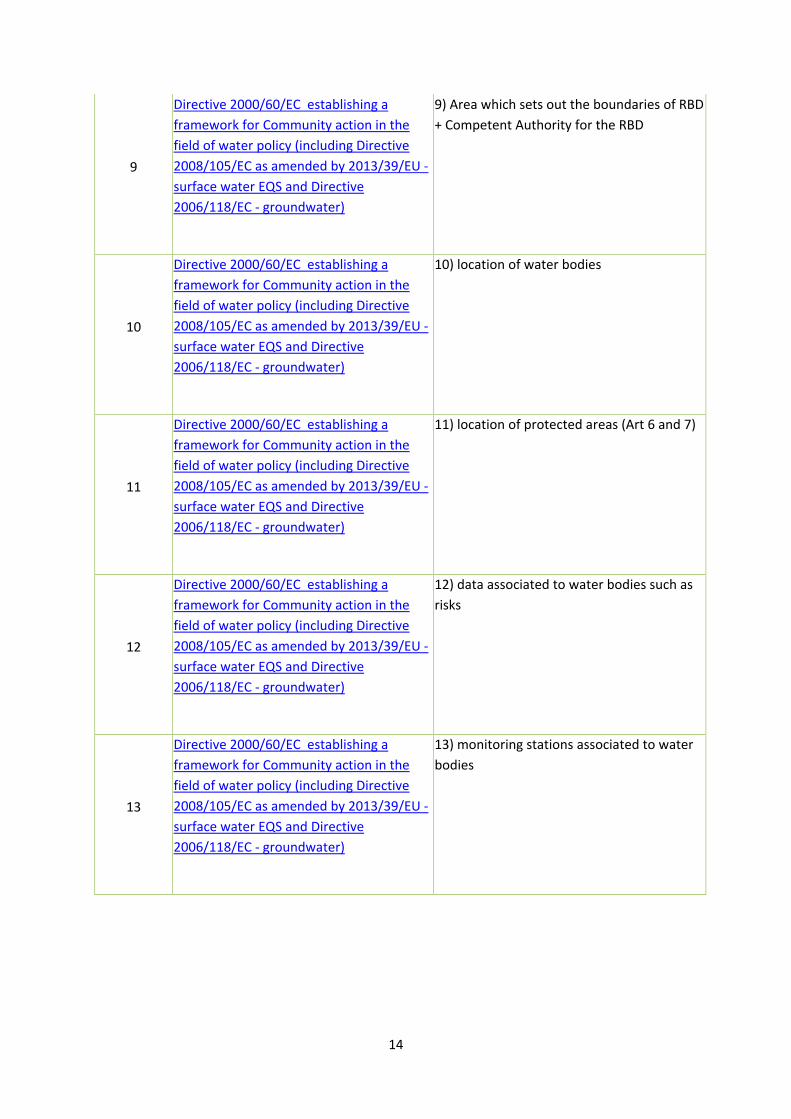
9
Directive 2000/60/EC establishing a
framework for Community action in the
field of water policy (including Directive
2008/105/EC as amended by 2013/39/EU -
surface water EQS and Directive
2006/118/EC - groundwater)
9) Area which sets out the boundaries of RBD
+ Competent Authority for the RBD
10
Directive 2000/60/EC establishing a
framework for Community action in the
field of water policy (including Directive
2008/105/EC as amended by 2013/39/EU -
surface water EQS and Directive
2006/118/EC - groundwater)
10) location of water bodies
11
Directive 2000/60/EC establishing a
framework for Community action in the
field of water policy (including Directive
2008/105/EC as amended by 2013/39/EU -
surface water EQS and Directive
2006/118/EC - groundwater)
11) location of protected areas (Art 6 and 7)
12
Directive 2000/60/EC establishing a
framework for Community action in the
field of water policy (including Directive
2008/105/EC as amended by 2013/39/EU -
surface water EQS and Directive
2006/118/EC - groundwater)
12) data associated to water bodies such as
risks
13
Directive 2000/60/EC establishing a
framework for Community action in the
field of water policy (including Directive
2008/105/EC as amended by 2013/39/EU -
surface water EQS and Directive
2006/118/EC - groundwater)
13) monitoring stations associated to water
bodies

15
14
Directive 2000/60/EC establishing a
framework for Community action in the
field of water policy (including Directive
2008/105/EC as amended by 2013/39/EU -
surface water EQS and Directive
2006/118/EC - groundwater)
10) data related to water bodies for many
quality elements [ENV C1 comment: actually
this is reported in the XML data which is
linked to the GML - but not only that , there
are many other attributes at water body
level that are reported]
15
Directive 2007/60/EC of the European
Parliament and of the Council on the
assessment and management of flood
risks.
14) preliminary flood map
16
Directive 2007/60/EC of the European
Parliament and of the Council on the
assessment and management of flood
risks.
15) Flood Hazard Map
17
Directive 2007/60/EC of the European
Parliament and of the Council on the
assessment and management of flood
risks.
16) Flood Risk Maps
18
Directive 2007/60/EC of the European
Parliament and of the Council on the
assessment and management of flood
risks.
17) Management Units and Competent
Authority
19
Directive 2008/56/EC of the European
Parliament and of the Council establishing
a framework for community action in the
field of marine environmental policy.
18) marine regions and sub-regions incl.
Assessment units
20
Directive 2008/56/EC of the European
Parliament and of the Council establishing
a framework for community action in the
field of marine environmental policy.
19) monitoring stations
21 Council Directive 98/83/EC on the quality
of water intended for human consumption.
20) DWD water supply zones
22 Council Directive 98/83/EC on the quality
of water intended for human consumption.
21) DWD small water supplies

16
23 Directive 2006/7/EC concerning the
management of bathing water quality
22) data (measurement, monitoring)
associated with DWD zones
24 Directive 2006/7/EC concerning the
management of bathing water quality
23) BWD bathing areas
25
Council Directive 92/43/EEC on the
conservation of natural habitats and of
wild fauna and flora
24) biogeographical regions
26
Council Directive 92/43/EEC on the
conservation of natural habitats and of
wild fauna and flora
18) marine areas
27
Council Directive 92/43/EEC on the
conservation of natural habitats and of
wild fauna and flora
25) various habitat maps using INSPIRE
geographical grid system
28
Council Directive 92/43/EEC on the
conservation of natural habitats and of
wild fauna and flora (Including Commission
Decision of 18 December 1996 concerning
a site information format for proposed
Natura 2000 sites)
26) location of sites
29
Directive 2009/147/EC (Codified version)
replacing Directive 79/409/EEC) on the
conservation of wild birds
24) biogeographical regions
30
Directive 2009/147/EC (Codified version)
replacing Directive 79/409/EEC) on the
conservation of wild birds
18) marine areas
31
Directive 2009/147/EC (Codified version)
replacing Directive 79/409/EEC) on the
conservation of wild birds
25) various habitat maps using INSPIRE
geographical grid system
32
Directive 2009/147/EC (Codified version)
replacing Directive 79/409/EEC) on the
conservation of wild birds
26) location of sites
33 EU Regulation (EU) No. 1143/2014 on
Invasive Alien Species
27) location of surveillance stations, facilities
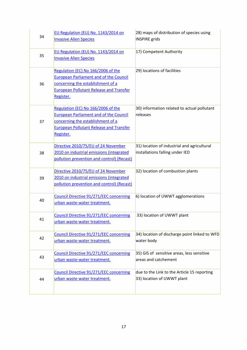
17
34 EU Regulation (EU) No. 1143/2014 on
Invasive Alien Species
28) maps of distribution of species using
INSPIRE grids
35 EU Regulation (EU) No. 1143/2014 on
Invasive Alien Species
17) Competent Authority
36
Regulation (EC) No 166/2006 of the
European Parliament and of the Council
concerning the establishment of a
European Pollutant Release and Transfer
Register.
29) locations of facilities
37
Regulation (EC) No 166/2006 of the
European Parliament and of the Council
concerning the establishment of a
European Pollutant Release and Transfer
Register.
30) information related to actual pollutant
releases
38
Directive 2010/75/EU of 24 November
2010 on industrial emissions (integrated
pollution prevention and control) (Recast)
31) location of industrial and agricultural
installations falling under IED
39
Directive 2010/75/EU of 24 November
2010 on industrial emissions (integrated
pollution prevention and control) (Recast)
32) location of combustion plants
40 Council Directive 91/271/EEC concerning
urban waste-water treatment.
6) location of UWWT agglomerations
41 Council Directive 91/271/EEC concerning
urban waste-water treatment.
33) location of UWWT plant
42 Council Directive 91/271/EEC concerning
urban waste-water treatment.
34) location of discharge point linked to WFD
water body
43 Council Directive 91/271/EEC concerning
urban waste-water treatment.
35) GIS of sensitive areas, less sensitive
areas and catchement
44
Council Directive 91/271/EEC concerning
urban waste-water treatment.
due to the Link to the Article 15 reporting
33) location of UWWT plant
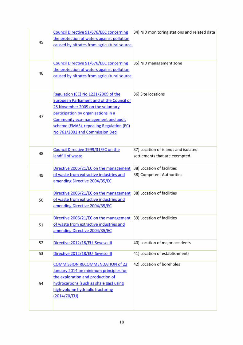
18
45
Council Directive 91/676/EEC concerning
the protection of waters against pollution
caused by nitrates from agricultural source.
34) NiD monitoring stations and related data
46
Council Directive 91/676/EEC concerning
the protection of waters against pollution
caused by nitrates from agricultural source.
35) NiD management zone
47
Regulation (EC) No 1221/2009 of the
European Parliament and of the Council of
25 November 2009 on the voluntary
participation by organisations in a
Community eco-management and audit
scheme (EMAS), repealing Regulation (EC)
No 761/2001 and Commission Deci
36) Site locations
48 Council Directive 1999/31/EC on the
landfill of waste
37) Location of islands and isolated
settlements that are exempted.
49
Directive 2006/21/EC on the management
of waste from extractive industries and
amending Directive 2004/35/EC
38) Location of facilities
38) Competent Authorities
50
Directive 2006/21/EC on the management
of waste from extractive industries and
amending Directive 2004/35/EC
38) Location of facilities
51
Directive 2006/21/EC on the management
of waste from extractive industries and
amending Directive 2004/35/EC
39) Location of facilities
52 Directive 2012/18/EU Seveso III 40) Location of major accidents
53 Directive 2012/18/EU Seveso III 41) Location of establishments
54
COMMISSION RECOMMENDATION of 22
January 2014 on minimum principles for
the exploration and production of
hydrocarbons (such as shale gas) using
high-volume hydraulic fracturing
(2014/70/EU)
42) Location of boreholes
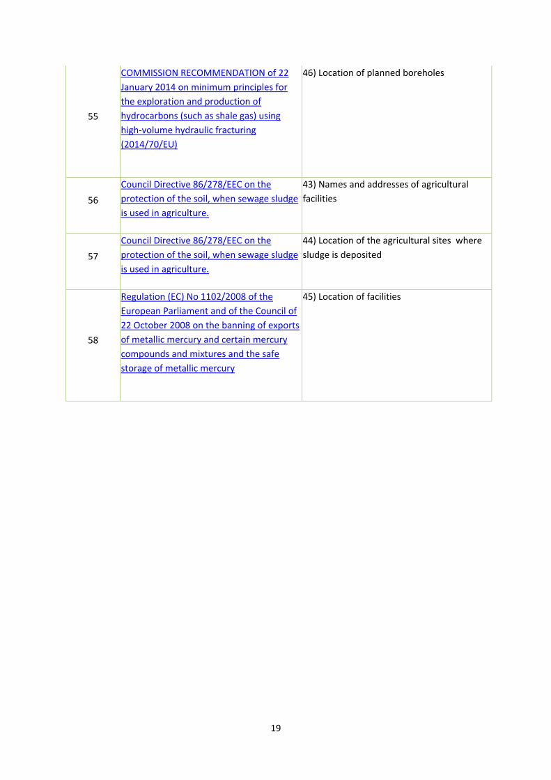
19
55
COMMISSION RECOMMENDATION of 22
January 2014 on minimum principles for
the exploration and production of
hydrocarbons (such as shale gas) using
high-volume hydraulic fracturing
(2014/70/EU)
46) Location of planned boreholes
56
Council Directive 86/278/EEC on the
protection of the soil, when sewage sludge
is used in agriculture.
43) Names and addresses of agricultural
facilities
57
Council Directive 86/278/EEC on the
protection of the soil, when sewage sludge
is used in agriculture.
44) Location of the agricultural sites where
sludge is deposited
58
Regulation (EC) No 1102/2008 of the
European Parliament and of the Council of
22 October 2008 on the banning of exports
of metallic mercury and certain mercury
compounds and mixtures and the safe
storage of metallic mercury
45) Location of facilities