the general establishment of geology and mineral … · the general establishment of geology and...
TRANSCRIPT

1

2
The General Establishment of Geology and Mineral Resources foundation and assignment
The General Establishment of Geology and Mineral Resources based upon decree no.136 dated in 1977 which is replaced of geological research directorate to be followed with Ministry of petroleum and Mineral resources , in order to entrust with the following assignments :
Setting out all reconnaissance works for mineral resources and beneficial rocks by using different means and scientific methods .
Doing all prospecting works by using geological , geophysical , geochemical , and laboratory methods , rotary and mining drilling assignments as well . performance each concentration tests with going out ore treatments to know the amount and quality of ore deposits , and what beneficial rocks , according to the informative data had been collected about their existence and economic feasibility studies .
Standing up all justificatory economic studies for the discovered mineral deposits ,and for further resources in preparation stage of putting them under exploitation programs .
Prospecting works for ground water in purpose of industrial needs in cooperation and coordination with other domestic sides .
Carrying out related geo-engineering studies concerning of collapsing not only dams , bridges , but also every construction facilities connected with public interest .
Establishing documentation center interacted in collecting data and storing all scientific documents that related to mineral resources exploration works .
Exchanging any scientific data and documents that are related to different specialized fields and interest of the establishment with other sides such as institutions , establishments , and local or outside administrations .
Sharing in every conference which is specialized in geological , geophysical , natural resources in frame of the government general policy of Syria .
Achieving and developing all necessary rules and regulations that connected with currently quarrying and mining works .
It is authorized to the establishment to exploit and extract any mining and quarrying materials due to no objection what so ever happened with other official sides , on the grounds that making particular companies .
It is possible to the establishment , handing over all related services with its concerned fields and
dealing with any contractor from inside or outside Syria .

3
The most significant procedures that are carried out by the General
Establishment of Geology and Mineral Resources
- Intending to activate and getting up the mass media about mineral resources as well as invitation
of offers from inside and outside Syria .
- Preparing promotion files of geological and mining studies , data of laboratories , and primary
technical feasibility studies for Syrian ores , in addition to let them later on available to the
investors . On other hand , indeed fulfillment industrial licenses were offered in coordination
with government of Syria or somehow independent way to invest and to manufacture many
domestic resources concerning of the following industries: cement – Portland , white cement ,
ceramic , and glass , as well as , marble and decorating stones , different building materials .
- Drawing plans and developing programs for fertilizing , phosphate , gypsum , asphalt industries ,
also , carrying on exploitation studies and manufacturing of Zeolite , Iron , Oil Shale , Dolomite ,
pure limestone ……and others .

4
INFORMATION ABOUT SYRIAN ARAB REPUBLIC
Location : The territory of Syrian Arab republic is situated at north west corner of Asian continent between two
longitude lines 35 ْ – 42 ْ and two latitude lines 35 ْ -37 ْ at the same time bordered from the north by
Turkey ,and Iraq from the east , while Jordan and Palestine from western south side to find at west
bordered by Lebanon and Mediterranean sea . it is considered as a significant center of trade and
transportation in the region and plays a good role of communication between the east and the west
countries .
Area : in total about /185180 / km2 , and border length in about / 2413 / km .
Geographic map of Syria in scale : 1/1000000 .
Topographic relief : It is possible to divide Syria into four regions from geographical point of view as follow :
- Coastal region which is limited between mountains and the sea .
- Mountains region contains uprising hills and mountain series from the northern parts of country
until its the south frontiers in parallel with Mediterranean sea .
- Internal region or plains region that included plains of Damascus , Homs , Aleppo , Hama, Daraa ,
Jesire (at eastern portion of the country ), as well as this region located at eastern side of the mountains
region .
- Syrian desert ( semi-arid region )locally called Al-Badeia and situated at eastern south parts of
Syria , in addition to adjacent of Iraqi and Jordanian borders. In Syria there are groups of mountain
series having an exceeded elevation / 2800 / m above the sea level . Besides , there are aggregates of
rivers with longest one called Euphrates /2330/km, and there are some others : Al-Khabour river and its
branches , Al-Aassy with its branches /571/ km . in addition, others rivers should be taken in account as
a major ones : Barada , northern and southern Al-Khabeir rivers , Al-Burgle river as well . when possible
dividing Syrian Territory into two divisions according to nature and structure topographic features ,we
can get the following regions :
a- Mountains region which is included the following units :
1- Mountain structures that have a graben model (coastal , Al Ghabb depression , Al-Zawieh ).
2- Mountain structures that have bending model (eastern Lebanon , palmyred) and big separated
depressions (Al-Daow , Al- Nusseiriyeh , Al-Mougher ).
3- Mountain structures that have faulted bending model (Al-Basset , Al kurd-Dagh) as well as the
separated valley between them (Afrien valley ).

5
b- Hills and plains which is included the following units :
1- Hills and plains were originated by horizontal layers (shore , floods , Jesire , continental sediment
plains , marine sediment plains , closed depressions).
2- Mountains structures with volcanic hills and plains ( Jabal Al-Arab , Houran plains , volcanic
mountains ).
Climate : The Syrian Arab Republic is located in worm moderate region into Mediterranean climate that it is
distinguished by rainfall fair winter , and it has a dry summer with two small transitional seasons only ,
usually gradual increasing in dry periods from west to east and from the north to the south while there is
gradual decreasing towered inside regions (Al-Badeia) where less than /100/ mm/yr . rainfalls decreases
from west to the east and from north to the south in annual precipitation is /35 -60/ milliard cubic meter
due to dried year or rainfall one . in exception of coastal region the temperature goes down until less
than zero centigrade cellulous within three months a year at the most of country ْ s regions , . Also, it
goes up to more than /35 ْ / into inside regions through two months July and August .
The amount of evaporation a year is between / 600 / mm at the coastal region while in Al-Badeia reach
to /2200/mm , in average /1900/ mm a year all over Syria .
Population Number of people : 22 million ,as 2009 predication
Growth average : 2.7 %
Distribution People in place : 50.2 % in the cities , 49.8% in the countrysides
Density people in place : 119 person /km2
Infrastructure : Roads Syria has a modern net of roads with total length about /45/ thousand kilometers distributed as
following : /7600/ km main roads – /1900/km highways – asphaltic roads /27500 / km – paved roads
/8000/ km as well as leveled tracks . all mentioned before are covered main cities , villages and towns of
Syria .
Railways In Syria there is a good net of railways connected all centers of Syrian provinces and the major cities ,
with total length /2238/ km and there are branches from main one to all significant industrial areas and
economic constructions such as ( sand and phosphate mines – electrical power stations – factories of

6
cement , steal , paper , glass , and cotton gins – Euphrates dam – major industrial places – and number of
oil fields …) .
Those railways are used for transportation passengers , goods , agricultural stocks , raw materials and
different products among Syrian cities from and to sea ports .
Energy There are (25) generating stations belongs to Syria for generating electrical energy in actual capacity /
7000 / mega electrical watts . As groups of the generating stations are forming different types in due to
(water – steam – gas – fuel ) . where steam and gas stations are using heavy oil and gas . by the way , the
government during /2015/ is planning to built seven new generating stations mainly depended on gas in
actual capacity / 3400 / mega watts .
Water Whole hydrological and hydro-geological (surficial and underground water ) resources in Syria are used
by several sectors which are having a social , economic , housing and services of industrial and
agricultural activities . it has been estimated the amount of water consumption in about / 6.4 / milliard
cubic meter in 1980 and /12.85 / milliard m3 in 2000 , while in 2030 will be about /24 / milliard m3,in
addition there is /8.84 / milliard m3 used in irrigation whilst in drinking water and residence uses the
amounts reached to / 1.2 / milliard m3 through year 2000 . it is expected the consumption in 2025 will be
/ 2.5 / milliard m3 in average / 200 / liter for each person . where in industrial field might be the amount
forms 2% of used water of agricultural , irrigation , home uses. That is give the government the motive to
built small moderate and big surficial dams in order to serve water collecting technique for useful needs ,
gross of built dams is ( 176 ) .
Harbors As matter of fact Syria considered as one of the major openings in middle east towered the western
hemisphere according to trade mutual activities and import / export moves . Furthermore , Syria has two
harbors (Tartous and lattakia ) that both of them were developed in suitable way for importing and
exporting requirements installing all required machines and equipments in Tartous port for storing and
loading phosphate, cement , phosphate fertilizers and different products .
Airports There are six airports in Syria : international Airport of Damascus , international Airport of Aleppo , Basil
Al-Assad Airport in lattakia , Deir Ezor Airport , Qamishely Airport , and Tudmor Airport .

7
the most important airport is international Airport of Damascus where it is located at east side of
Damascus city in far distance (30) km .
Industrial cities and free zones In purpose of improving the commercial and industrial activities and promotion of trade exchanges , it has been established industrial regions in the most of Syrian cities and getting a significant one in Aadra ْ
s area which is located in the countryside of Damascus , also , another three places existed : in Hassia
(Homs) , in Tal Najjar (Aleppo) , and in Deir Ezor . They are contain tens of industries in small and
medium sizes , actually many free zones were constructed in Damascus and Aadra , in international
Airport of Damascus , Aleppo , Lattakia , Tartous , Daraa cities as well . on other hand accomplished a
several industries which are related to mineral resources and energetic supports in Syria .
Economy and mining activities Mining sector and attached industrial sectors are being gained an effective role in national economy of
Syria due to a lot of considerations as following :
- Rising in quality of productivity factors in this sector
- Integral and tight relationships of this industrial sector with other once .
- Contribution of this sector in supplying local market needs of different products that is make
targeting the demand of foreign currency in order to share in process of adjusting of commercial
exchanges balances with the outside countries .
The government of Syria supported and encouraged sector of industry and mining , with having about
20% aide of (G.D.P) gross domestic product , therefore , this sector sounding pleasant for giving a new
job opportunities and absorbing a great deal of labors with decreasing of imported raw material that are
needed for various industries and markets , in addition , encouraging and assisting many industries those
are really depending on local ores.
Syria follows multi-economic trends policy through fulfill cooperation of the three sectors (public –
private – combination of them ) even though public sector still possessing the most important productive
companies with the major service establishments. Ministry of industry was able to cease regression of
productivity rate that goes up in middle of eighties (1980 ْ s) , as well as to conduct touched promotion
in invested capital funds via industrial establishments as an effective indication for significant growth
when was happened .

8
Geology of Syrian Arab Republic
Syrian territories are forming (185.18)thousand square kilometers , the northern part of Arabian peninsula platform and distinguished by relatively complex of geologic and structural setting that are represented as a main geo-environmental units in consisting of Syrian lands where concerning lithologic-stratigraphic and structural settings as well as history of the evolution as an important stage during past period of times to understand whole structure and times of the dominated evolution through Mesozoic , Cenozoic and recent periods .
sedimentary rocks are exposed In Syrian territory ( mostly carboniferous rocks and in less degree marl , fragmented materials and evaporated rocks ) extended over geological times between upper Triassic and Neogene , making about 75% of lands in Syria while the rest part of it covered by volcanic rocks widespread as basalt flows into upper Jurassic and lower cretaceous besides basalt shields covered a vast areas on western south , middle western parts , and northern east parts of Syria which are related to Neogene – Quaternary , in addition to massive Ophiolite rocks and associated volcanic sedimentary rocks located at north and northern west parts of Syria .

9
This figure shown location of Geological Syrian Territories at northern Arabian Peninsula platform .
Mesozoic formations (K2-P3) and Paleogene rocks are forming successively all cores of anticlines ,
central parts , limbs of folding zones and uprising mountains series into Palmyrides folding zone , coastal
mountains series and Anti-Lebanon system of mountains . while the depressions and valleys are filled by
continental and marine Neogene, volcanic rocks as well these depressions and valleys separating them
folding zones and mountains series especially at northern part of Syria where existed as a segment of
outer zone of Mesopotamian unite .
Figures no.3 and 4 clarify distribution of overburden thicknesses related to periods of Paleozoic ,
Mesozoic and Cenozoic horizontally and vertically above crystalline basement in Syrian territory.

11
Fig.no.3 : showing horizontal facies distribution and changing of overburden formations thicknesses
(Paleozoic , Mesozoic , and Cenozoic ) spatially and timely according to both data of Syrian petroleum
company and the general establishment of geology and mineral resources.

11
Fig.no.4 : showing (3D) cross-sections of overburden formations and the changing of them horizontally
and vertically (according to data of Syrian petroleum company ) .

12
Most important sediments and discovered metallic indications :
Achieved prospecting works and geological studies over Syria leaded to deduct and to
estimate a significant reserves of metallic and non metallic natural resources , Also, The
General Establishment of Geology and Mineral Resources (GEGMR) was continued in
preparing several ores for exploitation and partly or totally manufacturing by related
companies of it, such as (phosphate ,marble , Asphalt , gypsum , sands , rock of salt ) or by
other industrial commissions and establishments that related to both sectors private and
public (phosphate fertilizers industry , cement , ceramic and other water accessories , glass
different chemical industry , and different building materials ) . In addition , supplying all
necessary reserves for all construction works in Syria for example: ( pebbles , sands ,
decoration and building stones ) .
There are outline of the most important demonstrations of metallic and non metallic ores in
Syria .

13
Phosphate
Specifications of phosphate ore :
It is sedimentary rock consisted of compacted and friable phosphate contains compounds of
phosphoric (carbonates flour apatite formed by chemical sedimentation as Oolitic and various
sizes of nodules (0.1-2) mm , and clastic materials (detrital materials , quartz sands ) cemented
by clayey , limey and sometimes siliceous .
Phosphate of Syria distributed into three areas as shown in the map .
Khneifiss phosphate deposits :
These deposits located at (60)km towered western south direction of Tudmor city and at
western Sothern limit of Jabal Al-Abtar . phosphate formations related to upper Campanian

14
age and consisted of intercalation of rock phosphate layers with friable sand phosphate
covered by white clayey limestone looks like Apoka and layers of clay , flint , quaternary
alluvium sediments , this phosphate formation consisted of two layers :
- Lower phosphate layer : it is considered as the thicker layer and composed of
phosphatic friable sand and rock phosphate deposited in interbedded with light gray
color sometimes crossed by intercalation of clayey limestone and sometimes flint lenses
. this layer in about thickness (5 - 12.70) m .
- Upper phosphate layer : it is (0.30 – 7 ) m in thickness and consisted of tough rock
and friable sand with intercalation of clayey limestone sometimes
two layers separated from each other by interbedded of clayey limestone and flint with
thickness (0,5 – 2 ) m , these layers dip in the location towered western north direction in
about inclination (15 – 35 ْ ) , but those inclinations are different locally due to effectiveness
of folding activities as well as this area stroked by lateral main fault has (East-West) direction
which is caused to divide the deposit into two portions (northern and southern ) where in
having open two mines called northern and southern mines . Also, formation of phosphate
was effected by secondary faults that is increased the geological structure much more
complication to make mining works more difficult as well .
Eastern phosphate deposits :
Eastern phosphate deposits located at far distance in about (45) km at western south direction
of Tudmor city , and at eastern south flank of Al-Sawaneh uplift
This area distinguished by simple tectonic structure and the layers having slightly inclination
(3 – 6) towered south and eastern south directions . layers of phosphate belongs to upper
Campanian formations and composed of holding phosphate formation of intercalation of
tough phosphate beds and friable with interbedded of clayey limestone and some clay levels
sometimes flint lenses covered by overburden consisted of foliated clay bed and clayey
limestone , hard conglomerate , and dismantled quaternary alluvium . thickness of
overburden increases towered inclination of layers to south eastern south direction until
become more than (20) m while successive phosphate thickness between ( 8 - 18 m and more
than (25) m in some localities .

15
South Al-Abtar phosphate deposit :
This deposit situated in southern slope of Jabal Al-Abtar and related to upper Campanian age
also it is consisted of two phosphates layers :
Upper layer in about (1) m thickness ,while the lower layer in (1.5 – 3 ) m .
GEGMR was chosen a limited area of Romanic grid and reserve development done by
Romans to category (C1) and the content P2O5= 26.66% and friable sand phosphate of raw
material equal to (50%) . it was raised the previous reserve category to assured reserve (B)
category and the average content of p2O5 = 28.05 % and friable sand phosphate (56%) .
Central phosphate deposit :
It is located at half part of western side of the area of phosphate in Al-Ghadir Al-hamel and to
the south of Khneifiss in far distance (5) km . the first stage of primary prospecting works
shown solidified ore , and the total thickness of phosphate layers in about (1.30 – 3.80 ) m and
they separated by siliceous limestone has thickness (0.30 – 0.60 )m . these phosphate layers
having folded setting into shallow syncline covered with quaternary sediments . actually , this
location not considered as an economic importance because of complicated topographic
settings and mining difficulties .
Ghadir Al-Hamel phosphate deposit :
This deposit situated at western ends of Ghadir Al-Hamel valley and phosphate layers
interbedded into upper Campanian , with setting horizontally almost .
In this deposit the ore composed of several beds (3 – 4) three of them clearly obvious with
maximum thickness (1.20 -1.40 ) m and in average thickness (0.20 – 0.60 ) m .
Wadi Al-Rakheim phosphate deposits :
Wadi Al-Rakheim phosphate deposits located at western north direction of Tudmor city and at
north of forth station of pipeline in far distance (26) km , identified in this location by Russian
geologist and topographers in 1962 and these deposits were studied in detailed with drawing

16
many schemes in different scales for especially phosphatic layer . wadi Al-Rakheim area
described as quite easy in topography with having horizontal phosphate beds . in addition in the
this area had been distinguished three phosphate layers : two of them related to Maastrichtian
age and one layer related to Campanian .
Al-Hamad area (Al-Sijri and Al-Habari ) deposits :
Al-Sijri and Al-Habari deposits situated at distance (85 – 140 ) km in south east of Tudmor , and
successive phosphatic layers one to three layers which are interbedded with marl and flint
sediments and they are related to lower Eocene . Ores of this area studied by soviets in 1962 for
Al-Habari deposit and drown a geological map in scale 1/50.000 covered an area /600/ km2
.Furthermore , rotary drilling and digging by hand were executed on that location where
estimated reserve was (414) million tons in (C2) category and in average of P2O5 equal to (16 –
19.50 %) while average thickness of ore for each layer between (0.30 – 0.50 ) m . on other hand ,
non of estimated reserve done for Al-Sijri deposit because of its poorness of ore tiny thickness .
Therefore , these deposits recognized as uneconomic deposits to be used directly .
Coastal area (Al-Hefeh) deposit :
In this area phosphatic deposits settled at western slope of Al-Anassriah mountains and at the east
direction of Lattakia in far distance (35) km , and as matter of fact deposits of this area generally
divided into three masses - rocks . Ain leilon mass considered as the most significant mass where
in the center of three masses located Ain Al-Tenah at north side while Al-Mhalba castle mass
situated at the south . Also, phosphatic deposits of this area related to Upper Campanian age .

17
Invested ores /m.t/ Thickness
/m
P2O5
%
deposit location
Ready
Extracted
Amounts
Extracted
Amounts
Available
Reserve
Studied
reserve
Potential
reserve
7 17.6 24.6 41 41 4-12 26-28 khnifiess
Palmyred
809 49 858 1716 1716 8-22 23-26 Eastern
& abbtar
70
-
70
176
607
1.3-3.8 22-26 Central
1.2-1.4 15-25 Wadi
ghdier Al-
Hamal
16-25 Wadi Al
rakhem
0.3-0.5 16-19 Sijre &
Habari
12 - 12 12 24 18-23 Hefeh Latakia
Mining of phosphate :
Phosphate exploitation taken place currently in two mines :
- Khneifiss mine : ore phosphate located under overburden reach to (70) m and
exploitation of phosphate layer in (4 -12)m thickness produce a concertized phosphate
in about (0.5) million tones a year .
- Eastern mine : two ore fronts (A- Eastern ) and (B- Eastern ) are undergoing of
exploitation after removing of some interbedded levels in (A) mine , having annual
production (1.77) million tones while (0.87) million tones of (B) mine .
Following of mechanical concentration of ore by using ( crushing and screening ) in
order to separate (- 5 mm) as ore phosphate then will be dried and sometimes soft
particles were separated by using cycloning operations to produce hopefully phosphate
without any dust .

18
Specification of concentrated phosphate (-5 mm):
EASTERN KHNEIFISS
MINE
CONTENT
28.5 - 29.5 % 30 – 31 % P2Os
47 – 49 % 48 – 49 % CaO
7 – 9 % 7 – 8 % IR
0.1 - 0.16 % 0.05 - 0.1 % CL
8 - 10 % 7 - 9 % L.O.I
2.5 - 3.5 % 2.3 - 3.3 % F
Production :
EXPORT AMOUNT Local Consumption Concentrated phosphate
(normal dried and wet )
2.5 Million Tones 500.000 Tones 2.5 million tones
- Transportation : using railway caravans that closed and contain /50/ tone capacity
each to fertilizers factory in Homs and to be exported via marine port of Tartus .
Developing projects :
Washing phosphate project started in Eastern mine (B) to produce at the beginning of 2005 with
annual capacity (1.2) million tones of washed and dried concentrated phosphate in equal of content:
P2O5 MgO CL
31% 0.8% 0.03%

19
Asphalt
Asphalt considered as one of the most important ores and taken a good rank of all natural
resources according to its reserves and uses that recognized as one main ores used in paving
roads also used in asphaltic plates , rolls of asphalt , isolating material of water and many
other industries that possibly used for energy and generating of electricity as well as for
extracting petroleum derivatives , these sedimentary rocks are carbonate and sand rich in
bitumen and organic materials.
Ore occurrences in Syria :
Kfereh area : it is in Lattakia province at north east of Lattakia in far distance (40) km
21
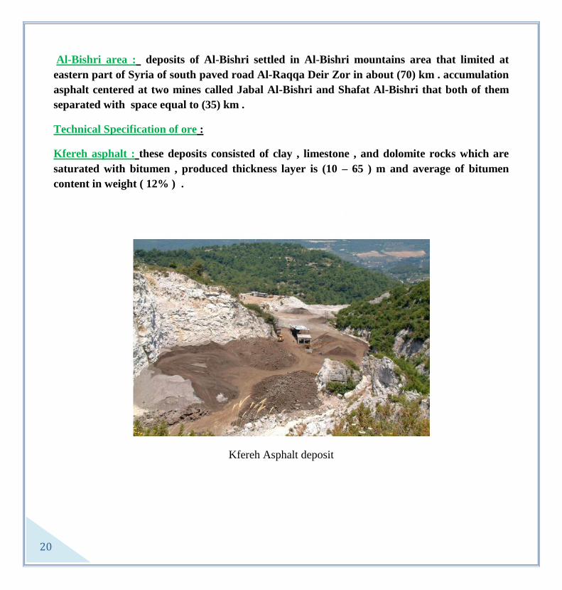
Al-Bishri area : deposits of Al-Bishri settled in Al-Bishri mountains area that limited at
eastern part of Syria of south paved road Al-Raqqa Deir Zor in about (70) km . accumulation
asphalt centered at two mines called Jabal Al-Bishri and Shafat Al-Bishri that both of them
separated with space equal to (35) km .
Technical Specification of ore :
Kfereh asphalt : these deposits consisted of clay , limestone , and dolomite rocks which are
saturated with bitumen , produced thickness layer is (10 – 65 ) m and average of bitumen
content in weight ( 12% ) .
Kfereh Asphalt deposit

21
Jabal Al-Bishri :
Forming two major layers which are called lower and upper asphalts where lower one in
thickness ( 0 – 13 ) m , average thickness (4.62) m .While the upper one in thickness (0 – 9 ) m
and in average ( 3.22) m . Those two layers covered an area (4) km2 , at the same time this
thickness decreases generally at central part of uplift towered rims until becomes branched and
vanished at the end , however the two layers separated by interbedded level composed of sands
and marl in thickness (0 – 2.90 ) cm . In addition , granularmeteric analysis indicated that
asphaltic sands grains between (0.1 – 0.3 ) mm and porosity of loose sands equal to (35%) in
size , in average (16%) with having similarity of asphalt saturation in its different parts , as well
as , percentages of asphalt are close to each other through chemical analysis
As a result of prospecting works on this location , calculated reserve in about (46) million tones
distributed according to recorded categories as follows :
Location Category of Reserve Amount by million tones
Jabal Al-Bishri B
C1
C2
5.21
51
5.21
Total C2 + C1 + B 64
Al-Shafat deposit :
Al-Shafat deposit forming of one formation in thickness (13) m at the middle part and its
decreases towered rims in thickness equal to (1) m and it is depositing in accordance with its
uplift structure and related oil slips with Al-Shafat fault while chemical and physical attributes
are in sameness of Jabal Al-Bishri asphalt that origin asphalt in the two deposits associated
with migration raw oil from its deep basic home traps on other words vertical and lateral
migration . Area of the location in about (3) km2 with an average asphalt thickness (3.28) m and
bitumen content (15.9%) while approximately estimated reserves ( 2 ) million tones. And , total
reserves in tow deposits is (67) million tones .

22
:Bishri asphalt -Specifications of Al
Al-Bishri asphalt contains (83 – 85 % ) in weight of sands and (15 -17 % ) of bitumen
Sands in its composition considered fine (- 50%) of weight and in sizes (0.16 – 0.4) mm
, an average (0.2) mm .
Granular distribution of sands and percentage of bitumen to constituent sands and
classifying grade (120 dmm) make it unsuitable for directly uses in roads paving.
Therefore , this study assured on modifying its specifications by adding refinery bitumen
and pebbles that crushed into special granular grades scales for using in many appropriate
mixtures forming covered asphaltic bed in paving of first class of roads .
Possibility uses :
1- Producing asphaltic mixture for paving roads .
2- producing asphaltic mastic for water isolation .
3- Generating of electricity .
4- Producing petroleum derivatives .
Mining of asphalt :
Raw asphalt produced from open mines of quarries as in Kfereh area (50.000) tones a year
and from Jabal Al-Bishri (100.000) tones a year .

23
Gypsum
Gypsum belongs to group of evaporation sedimentary rocks and it has the chemical
composition in percentages : CaO = 32,5% , SO4= 46.6% , H2O = 20.9%. Also, chemical
equation is : CaSO4 . H2O , in white color when it is generally pure that color will be changed
due to pollutes normally are clay ,dolomite , siliceous and iron compounds .
Existence of Gypsum in Syria :
It is existed in more than location and in more than one geological age , but its locations that
available for exploitation have an importance economic feasibility which are :

24
1- Gypsum of south of Al-Raqqa (north east parts of Syria) :
It is covered a vast areas reach to thousands of square kilometers and the most important of it
extended towered south and south east direction of Al-Raqqa city on the right bank of
Euphrates river until southern parts of Deir Ezor , Mayaden , and Abokamal cities as well as
it is extended to Al-Hassakeh and Ras Ain at north to be into Iraqian territories at east side
and still in Syrian borders existed in Al-Raqqa and Al-Rasafa where massive gypsum
deposited , it is tough and takes colors such as white or gray in thickness (5 -20 ) m , while in
Al-Hassakeh region there are two layers of gypsum : lower (oldest) related to lower Turonian
with thickness (200 – 300 ) m in white color and sugar cross –section interbedded with some
levels of clay ,marl , and limestone . However , the upper layer (recent) related to upper
Turonian to reach in thickness till (300) m with greenish white color , also, becomes more
recent gypsum deposits as much as we go towered eastern south direction to be Pliocene age
in Abokamal area at the Iraqian border .
Distributed deposits in Al-Raqqa and in south to eastern south sides considered as the most
significant deposits in Syria where potential reserve get a remarkable figure and percentage
of CaSO4.2H2O equal to (98%) that is very good for producing high quality gypsum
materials , depending on that these deposits cover a large areas reach to several square
thousands of kilometers
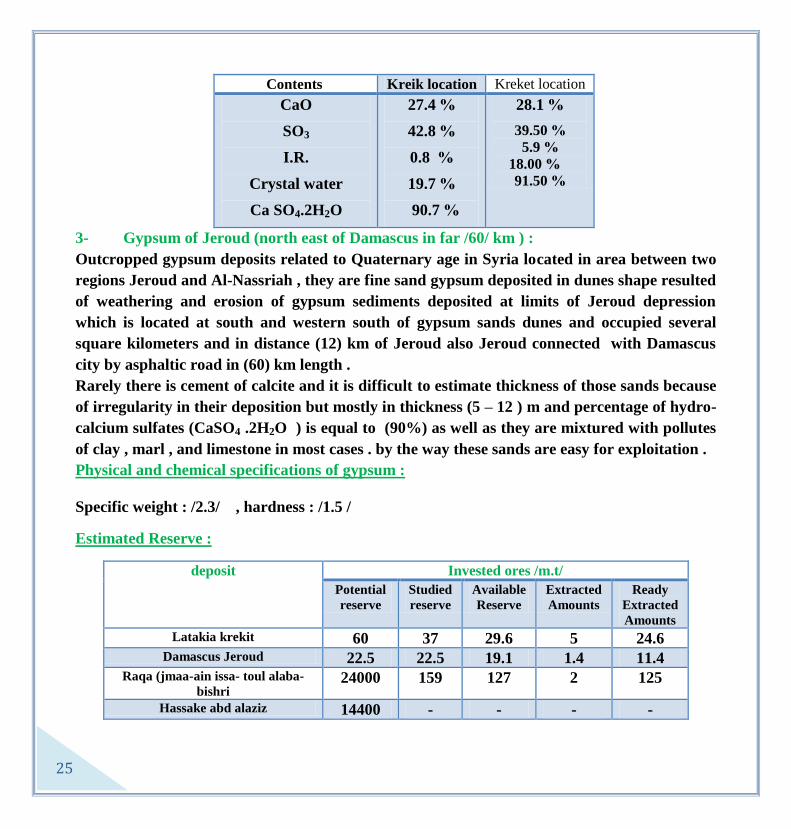
2- Lattakia gypsum ( coastal region ) :
These deposits widespread over an area (40) km2 to east and eastern north directions of
Lattakia city in far distance (25 – 30 ) km between roads of Lattakia - Hefeh – Slannfe and
main road that connected between Lattakia and Aleppo forming medium high hill covered by
thick layers of Pliocene deposits .
There are two major locations outcropped on limits called kreket at western north side and
kreik at eastern south side both of them related to geological age upper Miocene (Messinian
stage ) , maximum thickness (50) m and attributed with rapidly lateral and vertical changes in
thickness and quality by their affection of sever karst which causes kind of holes and ridges in
large and small dimensions even a lot of dolines existed that they were filled by marine
transitional Pliocene sediments and covered all located deposited gypsum in the area later on .
25
Kreket location Kreik location Contents
%28.1
%39.50
%5.9
%18.00
%91.50
%27.4
%42.8
%0.8
%19.7
% 90.7
CaO
SO3
I.R.
Crystal water
Ca SO4.2H2O
3- Gypsum of Jeroud (north east of Damascus in far /60/ km ) :
Outcropped gypsum deposits related to Quaternary age in Syria located in area between two
regions Jeroud and Al-Nassriah , they are fine sand gypsum deposited in dunes shape resulted
of weathering and erosion of gypsum sediments deposited at limits of Jeroud depression
which is located at south and western south of gypsum sands dunes and occupied several
square kilometers and in distance (12) km of Jeroud also Jeroud connected with Damascus
city by asphaltic road in (60) km length .
Rarely there is cement of calcite and it is difficult to estimate thickness of those sands because
of irregularity in their deposition but mostly in thickness (5 – 12 ) m and percentage of hydro-
calcium sulfates (CaSO4 .2H2O ) is equal to (90%) as well as they are mixtured with pollutes
of clay , marl , and limestone in most cases . by the way these sands are easy for exploitation .
Physical and chemical specifications of gypsum :
Specific weight : /2.3/ , hardness : /1.5 /
Estimated Reserve :
Invested ores /m.t/ deposit
Ready
Extracted
Amounts
Extracted
Amounts
Available
Reserve
Studied
reserve
Potential
reserve
24.6 5 29.6 37 60 Latakia krekit
11.4 1.4 19.1 22.5 22.5 Damascus Jeroud
125 2 127 159 24000 Raqa (jmaa-ain issa- toul alaba-
bishri
- - - - 14400 Hassake abd alaziz
26
Qualities of production gypsum :
Strengthen , Anti-burning , isolated material for sound and temperature , light weight and
Anti- water .
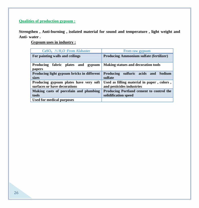
Gypsum uses in industry :
From raw gypsum From Alabaster :H2O ½ . CaSO4
Producing Ammonium sulfate (fertilizer)
For painting walls and ceilings
Making statues and decoration tools
Producing fabric plates and gypsum
papers
Producing sulfuric acids and Sodium
sulfate
Producing light gypsum bricks in different
sizes
Used as filling material in paper , colors ,
and pesticides industries
Producing gypsum plates have very soft
surfaces or have decorations
Producing Portland cement to control the
solidification speed
Making casts of porcelain and plumbing
tools
Used for medical purposes

27
BASALT
it is an extrusive basic rock existed as shields , flows , dikes . since volcanic activities started
during geological history of Syria , from middle Jurassic ( Al-Haramoun mountain , coast
mountains ) with relatively limited in spatial locations and in geological time , volcanic activity
retuned once again through Aptian age of Palmyrides , and Aptian – Albian stages of coast
mountains series , on other hand , quaternary – neogene volcanisms considered as one of the
most important volcanic eruptions were taken place in the country and widespread covered
flows of volcanic lava occupied (1/6 ) of Syrian territories area
Ore locations :
- Jabal Al-Arab depression : it is related to middle Miocene of volcanism ( BN12) ,
Pliocene (BN2) , lower quaternary (BQ1) , middle quaternary (BQ2) and recent (BQ4) .
basaltic lava and volcanic cones of most of southern territories and eastern southern part of

28
Syria , where /400/ volcanic cones noticed and volcanic rocks are exploiting as fabric and
decoration stones for buildings casing . Also , these industry still old fashion and manual as
well as there are many mills depending on basaltic rocks in order to get pebbles for cement
mixtures
- Sheen hill : volcanism here related to upper Miocene (BN13) and Pliocene (BN2) .
there basaltic lava in area extended from west side of Homs to adjacent neighboring limited
of Syrian coast line .
Volcanism here in type of fissure which did not developed to central type later on . basaltic
rocks converted , in central region as result of erosion and alteration factors , to laterite on
the surface , however , the general establishment of geology and mineral resources was
accomplished some studies on the region to determine results of alteration in brick industry
and others or even to extract Aluminum material .
- Al-Ghab rift valley : here volcanism in age of Pliocene (BN2) and quaternary (BQ1) ,
lava widespread in Jessir Al-shaghour and Jabal Al- Wastani , as well as , generated
volcanic cones . The general establishment of geology and mineral recourse carried out
several studies to use basaltic rocks and pure limestone distributed in the region for black
cement industry .
- Uplift Aleppo : it is related to upper Miocene (BN13
)and Pliocene( BN2) widespread at
south direction of Aleppo city and extended to eastern adjacent areas of Aleppo as covered
thin flows where there are several locations to establish cement industry and the general
establishment of geology and mineral resources is able to execute whole studies and detailed
prospecting works for both sectors of public and private interest .
- Coast mountains series : in these mountains series volcanism related to Pliocene ( BN2)
, Quaternary ( BQ) , and recent (BQ4) , also, lava flows distributed over the following areas :
Al-Raqqa – Deir Ezor – Al Hassakeh and Qamishli .
Significant studied areas :
- Southern region ( Al-Sweeda)
Many localities were studied in details :
Tal Al Harf : it is massive plateau of basalt related to Al-Zuluf formation (BN2) ,
average thickness is suitable for exploitation activities /14/ m of fine grains black basalt , in
addition , semi-industrial tests for basaltic casts and wool industries , were done in previous
Czechoslovakia .
29
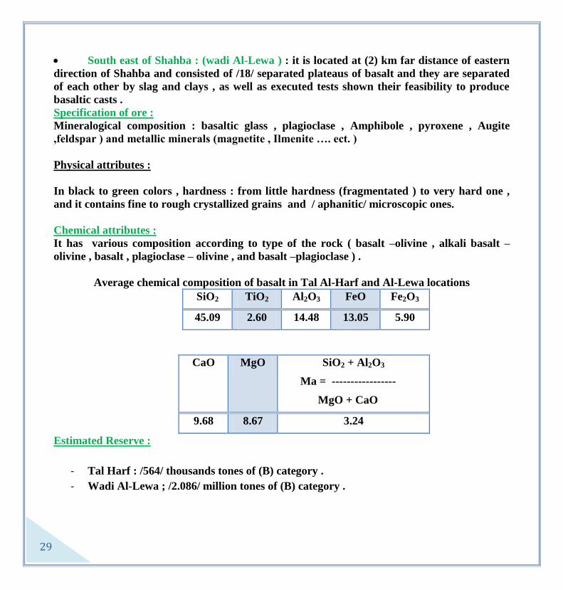
South east of Shahba : (wadi Al-Lewa ) : it is located at (2) km far distance of eastern
direction of Shahba and consisted of /18/ separated plateaus of basalt and they are separated
of each other by slag and clays , as well as executed tests shown their feasibility to produce
basaltic casts .
Specification of ore :
Mineralogical composition : basaltic glass , plagioclase , Amphibole , pyroxene , Augite
,feldspar ) and metallic minerals (magnetite , Ilmenite …. ect. )
Physical attributes :
In black to green colors , hardness : from little hardness (fragmentated ) to very hard one ,
and it contains fine to rough crystallized grains and / aphanitic/ microscopic ones.
Chemical attributes :
It has various composition according to type of the rock ( basalt –olivine , alkali basalt –
olivine , basalt , plagioclase – olivine , and basalt –plagioclase ) .
Average chemical composition of basalt in Tal Al-Harf and Al-Lewa locations
Fe2O3 FeO Al2O3 TiO2 SiO2
5.90 13.05 14.48 2.60 45.09
SiO2 + Al2O3
Ma = -----------------
MgO + CaO
MgO CaO
3.24 8.67 9.68
Estimated Reserve :
- Tal Harf : /564/ thousands tones of (B) category .
- Wadi Al-Lewa ; /2.086/ million tones of (B) category .

31
Mining method :
It is easy to be extracted because of its outcropped on the surface using quarries .
Possible utilization :
1- Producing of Basaltic wool
2- Producing of Basaltic casts
3- Producing of Basaltic fibers (Syrian basalt one of the best material to this kind of
industry in middle east )
Currently uses :
1- building stones , and paving roads .
2- Decoration stones .
3- In cement industry .

31
Trachyte
Trachyte is an alkali intrusive volcanic rock (one of basalt types ) , represents the last stage of
differentiation series of alkali basalt . minerlogically consisted of feldspar in percentage (75 –
80 %) , also , pyroxene and Ilmenite minerals . the most important distinguished thing is
stream well - arranged structure of feldspar crystals which are noticed by naked eye .
Ore location :
Trachyte rocks widespread in southern regions ( Al-Sweeda ) in many locations , the most
significant ore locations are :

32
1- Al- Kafer location (Al-Dhuhair ) :
Trachyte distributed in A-Dhuhair area at east to eastern north directions in /1/ km of Al-
Kafer village , forming fresh rocks in sizes ( 2 – 3 ) km3 and sizes decreases towered of limits
to become pebbles and stones while prospecting drilled wells shown that Trachyte deposits
situated in deep with homogenousity and fresh .
Trachyte exploited by companies which are related to private sector that produce ceramic ,
and through open quarry had been studied and prepared by the general establishment of
geology and mineral resources ,also still supervisor commission on production operation
where identified exploitation front specialized suitable one for each company . on other hand
, Trachyte powder added in percentage (25%) to palmyred clay and Jdedate Yabous for
manufacturing ceramic plats (in exception of paint ) . the general establishment of geology
and mineral resources is carrying out studies and discovering a suitable locations far of
woodlands or forested areas and old sites , to open exploited quarry having a large blocks as
decoration stones instead of Gabbro in cooperation with The General Company of Marble
and Decoration stones and gypsum .
2- Al-Khashaa Al-Tyer location :
It is located at south of Al-Memas village in /1/ km far distance in shape hill and in elevation
/50/ m , also , it forms massive rocks with (4 – 5) m3 sometimes ( 10 ) m
3 . Trachyte rocks
distributed as small hill called locally
" Al- Khashaa Al-Tyre " , while the south limit shown as massive blocks in sizes (4 – 5) m3
,
and in the other limits there is existed Trachyte undergone alteration process .
3- Al-houya location :
In this location Trachyte existed in forming hill called Tal Habeb where at the top hill there
are compacted masses in sizes of /1/ m3 and sizes decreases towered the base , generally fresh
Trachyte in this hill possible to be exploited for industry easily because of its near location to
asphaltic roads as well as there is no overburden to make obstacles for exploitation and
barren of different trees . in addition , there are other locations such as Al- Karss east of
Shahba .

33
Ore specifications :
Chemical composition :
L.O.I K2O Na2O Fe2O3 CaO MgO Al2O3 TiO2 SiO2
1.12 4.97 6.82 5.26 1.46 0.29 17.53 0.19 62.37
Estimated Reserve :
Al-Kafer location : (2.3) million cubic meters .
Al-Khashaa Al-Tyre : (2.3) million cubic meters .
Ore mining :
Outcropped ore as masses and extracted by open mines on surface and with low cost ,
nowadays exploited from Al-Kafer ( Al-Dhuhair) mine by companies of public and private
sectors .
Ore utilization :
- Ceramic industry : (added 10 – 15 % ) as Trachyte powder to the mixture of ceramic
raw materials .
- Decoration stones : (marble) due to its high hardness and its distinguished dark green
color .

34
Scoria
Volcanic scoria is originally basaltic lava raised up to the surface and flied in the air as result
of successive and explosive volcanic activities , existed as pure scoria around volcanic cones in
accordance with dominated wind direction during volcanic activities however , dimensions of
the material decreases as much as we goes far away of cone to become volcanic ash . scoria is
glassy lava rich in porous but petrographically aspect of crystals of plagioclase and olivine
into glassy ground .
Ore location :
Deposits of this ore widespread over vast lands and in huge amounts in the following areas :

35
1- Southern region : Tal Shehan ( Shahba area)
Scoria of Tal Shehan considered as one of the best location of exploitation due to quality and
mechanical and physical specifications , it is consisted of fragile basaltic lava with high
porous as result of successive and explosive activity of Shehan cone which estimated in about
/100/ successive action .
petrographically it is glassy structure contains a little micophenocryst of olivine while it
appears in glassy ground , aspects of crystallization of plagioclase which is one an important
existed mines in the southern region due to quality , amount and mechanical and physical
specifications . in this area there are three types of light , medium , and heavy volcanic slag
with size weight ( 0.72 – 1.57 ) gram/cm3 and porosity (29 – 75 % ) the average size weights
for scoria materials is (600) gram /cm3 and grain measurements (7mm) , also in cases of
measurements less , as much as we goes far away from the explosion center . studied
location by German company B.C in 1983 and this study containing geological study ,
estimation of reserve with doing laboratory analysis and executing semi-industrial tests for
production scoria industry :
Basaltic wool , light board of preconstruction , light weighted of moulded bricks , filtering -
purring and isolating materials , and resistant cement-pozzuolana industry .
SiO2 TiO2 Al2O3 FeO Fe2O3 MgO CaO Na2O K2O L.I Total SiO+Al2O3
Ma = --------------
MgO+CaO
41.82 3.13 15.11 10.34 5.17 8.99 9.02 2.65 1.78 00 98.81 3.13
41.97 3.09 17.04 9.95 4.98 8.30 9.78 2.99 1.90 00 100 3.26
In addition , scoria existed in :
- Al-Qalah , Ghrara , Al-Gamal locations : they are a good types and close to scoria
specifications /Tal Shehan/, there are many locations where in tuff existed and contaminated
by red color such as cones of Majdel cones which are low qualities comparing with the other
locations and used in building works .
- Tal Dakwah location (countryside of Damascus)

36
In this location scoria is currently exploited of Tal Dakwah cone and used whole exploitation
capacity for cement industry with a good quality specifications that are resemble to tuff of
Tal Shehan ( used for cement industry at present ) . average thickness scoria is /25/ m .
SiO2 TiO2 Al2O3 FeO Fe2O3 MgO CaO Na2O K2O L.I Total
42.67 1.90 12.42 3.40 13.53 6.55 11.93 2.69 1.32 2.43 Tal
Dakwah
43.47 1.94 13.79 3.44 15.35 8.06 10.15 2.05 1.10 - Tal
Dakwah
2- Northern and eastern region ( Al-Hassakeh and Al-Raqqa )
It is existed in Jabal Kawkab (Al-Hassakeh) and in Al-Mankhar the eastern and the western
ones (east of Al-Raqqa ) .
Estimated Reserve :
Invested ores /m.t/ deposit
Ready
Extracted
Amounts
Extracted
Amounts
Available
Reserve
Studied
reserve
Potential
reserve
83 2 87.76 121.6 300 Damascus-talDakoue-shikhTloul
35 7 32 40 40 Swidaa-shihan-ghzara
- - - - 15 Raqqa-manakher
- - - - 20 Hassake-kokab
Ore specifications :
With high porosity (36 – 75 % ) , weight volume small (0.72 -1.57 ) gram/cm3 , and high
isolation .
Ore mining :

37
Scoria existed as loose material and outcropped on the surface to become an easy for quarry
extraction with low costs , on other hand it is currently extracted for cement manufacturing
and building works
Uses of ore :
1- Basaltic wool industry ( Tal Shehan ) .
2- Cement-pozzuolana industry ( Tal –Shehan , Al-Qalah , Ghrara , and Tal –Dakwah ) .
3- Light Bricks and preconstruction walls industries .
4- Isolated material for building .

38
Quartz Sand Quartz sand known since past ages and entered in many industries especially glass industry in
the Mediterranean region , then this industry was developed where there are more than /500/
kinds of industrial glass , and high degree of pure quartz sand used currently in electronic
calculators ,computers , light cells and in several other fields . quartz sand is a siliceous
sediments contain a high percentage of silica with grains sizes ( 0.1 -1.0 ) mm , sometimes
cemented by clay and lime or mixture of them.
Ore locations in Syria :
An important deposits of quartz sand outcropped in several places of Syrian territories as
geological formations which are related to base of cretaceous , Oligocene and lower Miocene .
sands of base of cretaceous represented by base sandstone formation with upper Aptian of

39
sands also these sands outcropped in southern part of Eastern Lebanese Mountain Series such
as :
Al-Zabadani , Al-Tkeiah , eastern southern slopes of Bloudan of Al-Haramoun
With thickness of sand layers into those formations between ( 15 – 25 ) m ,mostly colored
sands of iron oxides in exception some pure sand layers relatively in upper Aptian formations
near by Bloudan and northern Al-Zabadani and even adjacent areas of Al-Zabadani region of
north Beirut – Damascus road .
Also , sands outcropped into southern Palmyrides cores especially Mount of Al-Mazar where
quarts sand exposure as loose sand with red , bricks , yellow colors with thickness between (
40 – 50 ) m, related to Aptian age .
While Oligocene and lower Miocene sands distributed mostly on slopes of Palmyrides series ,
Mount of Al-Bishri , Wright side of Euphrates river until Abo-Kamal region which are
generally light color and consisted of fin to coarse quartz grains sometimes cemented by
carbonated materials . the best and the most significant deposits located in an area between
Homs , Qarytein , Damascus , and Jabal Al-Tabooq / Al-Bishri region / , and quartz sands
existed in the most important areas, as following :
Al-Qarytein region :
- Al-Daakaneh : it is located at north east of Al-Qarytein town in far distance (7) km and
connected with main road of Al-Qarytein , homs through dessert road that vehicles could
drive on it , quarries of sand appear as lens shape extended towered of slightly north east –
south west direction in length (5) km and wideness (80) m , as well as the maximum thickness
of quartz sand formation in the mine reach to more than ( 50 ) m and related to lower
Miocene .
L.O.I TiO2 MgO CaO Al2O3 Fe2O3 SiO2
51201-12.. 125. –
1216
1204 –
121.>
5521. –
1215
5216 –
12.1
12.. – 1215 1.2. - 06
Potential reserve is estimated in the studied part of mine with more than (20) million tones .

41
Tulol Al-Khadariat – Dam location :
It is located at south direction of Al-Qarytein town in far distance / 9 – 10 / km ,and quartz
sand formation widespreads in this location in wide extension horizontally at eastern side
while in becomes narrower at southern west side with formations related to lower Miocene
above limestone wall which is related to Oligocene and it is a loss fine sands in sizes from
medium to coarse in general colored with white to yellow or brick- red . the study completed
in the eastern part where sands distributed in large scale and in vast area about /1.2/ km 2 ,
the thickness reach to more than / 70 / m in maximum layer , then it decreases towered east
and northern east directions with estimated dip of base layers in about / 14 ْ - 18 ْ / .
L.O.I TiO2 MgO CaO Al2O3 Fe2O3 SiO2
0210 – 126. 1256 – 1211 1211 – 121.> 0240 – 1211> 5210 – 12.. 12.1 – 1214 1.2.1 – ..210
Al-Rmilli location :
This location situated at north western parts of Al-Qarytein town with distance / 7/ km and
widespreads on large extensions horizontally forming lengthen zone strikes north east – south
west direction , quartz sand ores in all sides of the location attributed by pure white sands in
exception surficial layer until /3/ m in depth and contaminated with calcite and iron most of
parts , however these sands distinguished by purification in proportions of depth and by
homogenousity plus impossibility of classification and separating of sands due to different
uses vertically because of un happening clearly contrast in the chemical and grainlometric
compositions at that direction . as matter of fact sand formation attributed from the middle
part that means in the center of lens towered the limits with narrowing of outcropped area
with a little thickness of formation , also there is increasing of effecting the surficial
contamination and covered layers , then sands which are located at east north and south west
rims having the followed table :
Al-Kalamoun region :
L.O.I TiO2 MgO CaO Al2O3 Fe2O3 SiO2
520. – 12.6 1241 – 121. 1241 – 121. 520 – 125 52.1 – 1251 12.1 – 121. 11210 – 1126

41
During middle and lower Miocene formed set of sandy clastic formations consisted of quartz
sand and quartz sandstone and limestone in regions of :
Al-Thanaya – Al Sahel – Yabroud - Fletta . And ,on the eastern slopes of Mount Kawdan .
sands of this area are mostly pure with white color as well as yellow to red levels , especially
middle Miocene and sandy formation thickness in dominated area between / 3/ m in Mount of
Kawdan to reach /100/ m in Al Sahel area . in addition , on other hand noticed the
intercalation of sandy formations with several levels of quartz sandstones , limestone , and
conglomerate .
Al-Thanaya deposit :
This deposit located at eastern north direction of Damascus city in far distance /30/ km , and
extended in width of zone form between ( 100 – 250 ) m and it takes strike north west – south
east direction to distance / 6 / km , in thickness ( 15 – 50 ) m , also , these sands colored by
white to yellow as well as red sands dedicated at the base of the formations .
- Al-Nabek deposit ( Al Sahel ) :
In far distance of /2/ km to the east direction of Al Sahel town this Deposit situated and
extended in sand sediments to / 2/ km with a significant deposits where in Mount Al
Mikharsham and in thickness /30 / m , sometimes interbedded with limestone . sands
consisted of fine to middle sizes and different colors from light yellow to light gray and white .
L.O.I MgO CaO Fe2O3 R2O3 SiO2
126 12. 12. 126 521 1021
Al-Kawdan deposit :
This one settled at north eastern direction of Qara town in far distance / 4 / km it is consisted
of quartz sand have calcite cement mostly covered with limestone and sands composite of fine
to middle sizes in white and yellow even light gray color . percentage of siliceous of ore
between (93.67 % - 94.58% ) , and according to most of these sediments are covered and they
L.O.I TiO2 MgO CaO Al2O3 Fe2O3 SiO2
.20 – 521 - . – 12. .21 – 12. 121 – 62. .2. – 525 1.24 – .12.

42
are existed in limited amounts with containing of carbonate averages . it is not advised to be
exploited in purposes of anthers except of building needs .
Yabroud deposit ( Al-Fletta ) :
Here the deposit is related to middle Miocene and formed zone in average width /200/ m , in
addition , it is extended /2/ km consisted of interbedded of sandy rocks and others such as
limestone and conglomerate . thickness of sands between ( 10 – 20 ) m with yellowish white
pure sands in some locations , also red sands noticed in the western northern parts of this
formations .
Generally sands are fine grains and rarely medium to coarse , grains have well rounded
limits and they are pure in exceptionally existed in white sand formations with high
purification of colored outcrops . percentage of insoluble materials of many samples between (
94 % - 99.43% ) , this location considered as one of the most important locations of quartz
sand in Al-Kalamoun region and it is possible to satisfy sand needs of building purposes and
other industries in the region .
Eastern Lebanese mountains series region :
Formation of quartz sand related to Aptian called base sandstone and consisted of quartz
sandstone with medium to coarse grains ( 0.4 – 1.6 ) mm and in medium compaction to fragile
. This formation contains plus to quartz kind of small carbonated pebbles with pisolitic iron
thin remains . in addition these sands distinguished with bad grains classification and with
yellow , red , dark brown colors because of richen in iron materials . The most important
outcropped due to the extension and the amount even to small tectonic effectiveness , these
outcropped deposits basically located in surroundings of Al-Rawdha area , Jabal Al- Saquffa
slopes , Dam wadi Zarzar , and wadi Al-Dardar , then Jdedate Yabous and at the east side of
deposits considered in the second rank where more than /70/ m outcropped of base sandstone
while sands of upper Aptian formations descriptive in a little thickness and their interbedded
with several levels of clay , limestone , silt ,and iron different rocks have mostly yellow , red ,
and brown colors as well as they are generally fine grains and rarely white to gray levels were
noticed .

43
Also , insoluble materials in base sandstone deposits are in about ( 83.44% – 95.19 % ) while
in upper Aptian sands between ( 89% – 98.47 % ) .
The most significant attributes of sand deposits in the area is the possibility of finding of
coarse sands but it is not expected to find a large amount of deposits with valuable reserves
and stable of coarse sands to become a huge investments because of complicated tectonic and
lithological situations for the formations , in general , this area needs especially lower Aptian
to detailed prospecting works to discover most of covered parts of the deposits and to make
assessment of coarse sand content .
- Jabal Al-Bishri region :
Jabal Al-Bishri formed the northern eastern limit of Palmyrides and considered as one of the
biggest uplifts in the northern region of theses series which is related to outcropped rocks of
Jabal Al-Bishri of upper cretaceous , paleogene , and Neogene and quartz sands exposure
with quartz sandstone from upper Oligocene in alternated levels with carbonated rocks in
Jabal Al-Saibai , Jabal Tar Al-Haganeh where in sand formation not exceeds of /15/ m in
yellowish white to brick- yellow colors and sandy facieses dominated in particular in western
southern part of Jabal Al-Bishri in Jabal Al-Rahoum with thickness / 44/ m to decrease / 25/
m towered east direction , yellow to red in medium to fine grains of sands as well .
Actually , here sediments are distinguished in dominating loose sands deposits contain a weak
cementation, furthermore they are rounded sands in medium to fine grains colored by white ,
yellowish white , light gray and reddish brown. Also , deducted in a little thickness not
exceeded /50/ m .
Jabal Al-Tabooq location :
it is outcropped at western south of Al-Rasafa region in far distance /35/ km forming zone of
lower Miocene and kind of a slightly high hills with thin agricultural soil and different windy
sands .
yellowish white to yellow sands barely pure white in thickness /10/ m interbedded with thin of
levels of quartz sands in carbonate cementation has dark yellow color in thin slides at the top
part of the formations .

44
- Al-Rahoum location :
Sediments of Oligocene and lower Miocene in this area formed zone in width (200 – 1000 ) m
and making slightly elevation of hills , where sands at wall of crossed valleys with outcropped
formations thickness ( 15 ) m , fine grains sands in general take sizes ( 0.2 -0.8 ) mm , in
yellowish white to yellow , gray colors and sometimes in light brick .
- Wadi Al-keiar location :
Lower Miocene outcropped at west side of Al-Jeri valley in distance /4/ km forming zone in
width (300 – 400 ) m with dip towered western north direction in about / 5 ْ / and (22) m
thickness , these sands attributed with colors of yellow to light brown , fine to medium
grains, and in average insoluble materials with Hcl : 96.3 % .
- Wadi Al-Jeri location :
Oligocene and Miocene deposits are forming limits of uplift Al-Jeri and they are outcropped
in two narrow zones taken east – west direction at most with dipping towered north in (1 ْ -
5 ْ ) , in /10/ km extension , and (30 – 42) m thickness making successive hills in yellowish
white to light gray and purple violet light yellow colors in fine to medium grains .
Insoluble materials Hcl Fe2O3 SiO2
1021 - .025. 12.. - 1210 10 - 1624
- Al-boleia location :
It is located at east of wadi Al-Jeri in about / 6 -8 / km and quartz sand deposits related to
Oligocene and Miocene to make limited elevations of hills that covered by transported sand
Insoluble materials /Hcl/ CaO Fe2O3 SiO2
16 .25 124 152.
Insoluble materials ـHcl CaO Fe2O3 SiO2
1426 525 121 1.2.

45
formations due to wind effect and outcropped in Al-Boleia valleys which crossed it . Also ,
light gray Oligocene to reddish brown colors of fine sands in general . At the middle part of
it there are levels of organic limestone almost in thickness /6/ m. it is contained lengthen
crystals of plagioclase and different percentages of carbonates and compacted sands
cemented by calcite forming quartz sandstone in reddish gray color at the top part of
Oligocene .
while lower Miocene sands distinguished by thickness (20 – 34 ) m that getting yellow color
with reddish levels to violet and some white and light gray sand lenses , in fine to medium
grain sizes .
- Al-Shijri location :
Lower Miocene sediments are outcropped in zone width (300 – 500 ) m and extended to /14/
km at northern part and in /9/ km at southern part , these sediments consisted of fine to
medium grains of quartz sands in yellowish white to dark violet colors with goodness of
rounded grains . Also , sands exposure on crossed wall valleys in thickness more than /20/ m
, distinguished by existing of brightly white lenses set in extension /500/ m towered western
south of Al-Shafat village in /3/ km , however , these sands might be good and pure sands
suitable for glass industry while sands of Oligocene outcropped on surface directly in
relatively thin levels in reddish gray and brown colors.
In addition have fine grains and covered by clastic organic limestone formations with /6–12/m
- Nazrat Al-Bishri location :
Sands of lower Miocene outcropped in wall of Nazrat Al-Bishri contained a layer /3/ m ,
consisted of coarse fragments of quarts sand and pebbles in colored clastic materials
between greenish brown to light yellow or faint white at south of mentioned location
presented Miocene quartz sand in zone width between ( 400 – 800 ) m and extended to
several kilometers and in white to light gray colors formed in very fine grains with iron and
calcite pollutes . these sands are very important industry casts and standard sands , on other
hand at southern part near Al-Defena and wadi Al-Dede outcropped quartz sand and quartz
sandstone that are related to Oligocene and lower Miocene which are contaminated sands in
reddish rosy color and rarely yellowish sands have fine and medium sizes . in about (20– 37 )

46
m of two ages of sands intercalated by many levels of organic limestone and compacted
quartz sandstone mostly with present flint nodules in upper parts of lower Miocene .
- Wadi Ademah location :
In this location quartz sand which are related to lower Miocene in thickness more than / 10 /
m and covered layer exceeded towered the mountain where in directly quarry effectiveness
deducted in open way , medium to fine sands and contained gypsum in percentage ( 20% )
and in lower percentages of carbonates and iron oxides with yellowish gray to yellowish ,
rosy colors as well as insoluble materials between ( 81.7 % - 98.1 % ) . in general quartz sand
considered as sediments of Oligocene and lower Miocene in the region of Jabal Al-Bishri in
bad specifications alike chemical or granularmetery compositions and no way to recognize
those sands for using them as very good materials for industrial purposes have high quality
attributes but they are good for casts and building uses even for cement industry and others
.
At any rate , exploitation of theses sands are considered relatively as result of roughness of the
area and insufficiency roads that are connected with it .
Southern eastern region :
This region forming the northern limits of Uplift Al-Rutba and it is distinguished by
sediments of medium and lower Miocene which are contained sands and quartz sandstone ,
generally these sands considered pure in common and their grains fine to medium sizes , in
percentage of insoluble materials ( 92.85 % - 95.43 % ) of outcropped deposits in Al-Waar ,
swab , Al-meyiah valleys and it may used for building purposes .
Ore mining :
Dismantled and loose sands on surface most of the deposits and they are extracted by open
quarries in low costs . At present /1.4/ million tones production of extraction from open mines
contained pure and polluted quartz sand in order to supply industrial factories of glass ,
cement , ceramic , casts and for construction works .

47
- Casting industry :
Deposits of quartz sand in ( Al-Ramela , Al-Nabek , and in some Al-Bishri deposits ) are good
for direct industrial uses .
- Glass industry :
Today deposit sand of Al-Ramela is used for normal glass production and these sands
approach to become into standard formations set that considered useful for high quality glass
industry after applying process steps of separating classification , and washing .
- Hydrate glass industry ( sodium silicates ) :
hydrate glass smelting with sodium sulfate as plaster or meditative alkali reduction materials
or soluble medium for silicates and entering in several industries such as : soap , canning ,
wood , textile , soothing and polishing materials , paper , and metal plates …. , Qarytein sand
is very good one for this kind of industry .
- Cement , porcelain ,ceramic , and building materials industries :
Most of quartz sand deposits are useful for these kinds of industries .

48
Oil shale
Oil shale is a sedimentary rock consisted of fine grains contains unmatured organic materials
geothermally . in fact this material called kerogen produces a lot of amounts of hydrocarbons
liquid and gas that flammable when it is retorted ultimately .
oil shale considered as major economic importance deposits mostly deposited near the surface
or on the surface that gives permission to develop the field by surficial collecting or typical
mines underground . And , it is called a specific term of oil shale that sometimes named as a
future source energy .

49
Ore location in Syria:
Oil shale deposits generally belongs to determinate lithostratigraphic formation and to
several geological ages but they are different in their content and composition of organic
material in each other also for their mineralogical composition , then they have variety
thermal energy resulted of burning while oil shale deposits widespread in many area into
formations of upper cretaceous – Paleocene . the most significant locations are :
- Coastal mountains series :
Oil shale rocks related to theses ages as following :
Upper Jurassic – Cenomanian – Maastrichtian – Eocene – middle Miocene and considered in
this area in lower degree of importance due to results of analyzed taken samples from it .
- Blouzah location :
Oil shale deposits in this location belongs to Cenomanian that consisted of limestone and
clayey limestone rocks in thickness / 2 / m , while exploited conditions of the deposits are
difficult and complicated . results of analysis from taken samples indicated that these deposits
possess medium thermal energy in about / 1350 / kilo calories /kg with content of oil by fisher
method in between / 7% -8 % / , and content of sulfur / 2 % - 2.5 % / .
- Hinen location :
Outcropped oil shale related to upper Jurassic and consisted of several levels in average
thickness / 6 / m . And , result of taken samples analysis of this location indicated to bad
qualities deposits have average thermal energy / 610 / kilo calories / kg , oil content in about /
3% - 4% / , and sulfur content / 1% - 1.25 % / . Also, these deposits invaluable economically .

51
- Beit Samander location :
In this location oil shale deposits related to upper part of middle Eocene that are limestone
and clayey limestone rocks in average thickness / 25 / m , and situated in direct touch with
Ophiolite rocks . distribution of deposits are limited and in sever inclination reach to / 30 ْ /
while overburden is thick .
However , all results of analyzing some taken samples indicated to content of organic
materials between / 20% - 25% / and average thermal energy in about / 2000 / kilo calories
/kg , Also , resulted oil average is / 15% / . these deposits conserved as invaluable economically
ones from exploitation point of view .
Al-Nabek and Al-Dimas syncline locations :
Existed oil shale deposits in this region are situated into middle and lower Cenonian
sediments while studied significant locations in this syncline at Al-Mirah which is related to
Cenonian in thickness / 50 / m and indicated results of some samples are organic materials
content between / 10.6% - 13.32% / , thermal energy / 850 – 1200 / kilo calories/kg , as well as
these deposits outcropped in several locations such as ( Mafraq Maaloula – Al Twaney – Al
Nassriah – Halboun – Dummer – Al fegieh. ) .
- Hamah area :
Oil shale rocks existed in this area in many places : Souran locations – Al Mukharam – Tal
Dura , and studies with drilling works shown in Souran thicknesses of deposits in about / 40 /
m , average thermal energy / 400 – 850 / kilo calories /kg . these deposits recognized as bad
ones after indications of analysis results of taken samples of Al mukharam location having
thermal energy between / 1600 – 1800 / kilo calories /kg . in addition , results of analysis of
homs refinery explained that thermal energy about / 230 – 3100 / kilo calories /kg .

51
- Al-Kurd dagh area :
Soviet studies point out that outcropped bitumen rocks in this area has a vast distribution
with average thickness / 60 – 80 / m in the following locations : Qurah ghoul – Al Samalek –
Al Kourkan ) , average thermal energy of these samples about / 1123 / kilo calories /kg , in
average oil content / 8% - 9% / and sulfur content / 3.96 % / , but these deposits very
complicated from exploitation point of view .
- Palmyride series :
Geological , lithostratigrphical , and paleogeographical studies point out with results of drilled
boreholes in the area to existing of oil shale rocks and widespread over a large areas within
thicknesses between / 100 – 200 / m and at depths / 100 / m , Also study of taken samples
shown that thermal energy of them about / 1000 – 1200 / kilo calories /kg , as well as these
rocks related to Maastrichtian age which is the most important deposits due to thickness and
quality specifications .
Ore specifications :
- Thermal energy :
It is considered as one the most significant factor or assessment quality specifications of oil
shale rocks that determine possibility of and field uses of these rocks especially if the target
was burning directly in electrical energy plants and the values of thermal energy related with
organic material content percentage plus the quality of this material . it is seem to be values of
thermal energy change widely between / 450 – 1700 / kilo calories /kg and the study shown
thermal energy of these deposits where it is increased towered the depth in general .
- Resultant oil :
Actually values of resultants oil directly and proportionally related with percentage and
quality of organic material in the rock and Syrian oil shale considered as one acceptable type

52
of oil shale to produce oil getting oil production in about / 60% / of organic material content
and resultant oil of Daraa mine between / 7 % - 10% / .
- Sulfur content :
Sulfur considered as one of harmful impurities that cause corrosion metal of furnaces from
side and from other side part of them converted to dangerous gases environmentally during
burning operations . Furthermore , increasing of percentage sulfur in resultant oil of
abstraction of retorting process recognized as a negative indication , but available results of
analysis pointed out that sulfur content of Syrian oil shale rocks ( Daraa mine ) in about / 1.3
% - 2.1% / and sulfur content / 70% - 80 % / which is throwing with residual ash in
remaining percentage that transformed to volatile compounds .
- Moisture :
During the burning operation and thermal treatment of oil shale , percentage of actual
moisture content in the rocks possess a large scale of importance , and all studies with applied
experiments pointed out that lost temperature through drying moisture shale (9% - 12% ) is /
32% / of required thermal energy to burn the shale . results of Syrian oil shale studies
according to moisture percentages not exceed / 10% - 15% / .
- Ash :
It is wastes inflammable , increasing remains of resultants ash after burning operations
considered as negative indication in general . According to burning Syrian oil shale ( Daraa
mine ) resultant ash distinguished by the following specifications :

53
Ash with high content of phosphate in average / 17% / that pointed out to the
possibility of ash using in reclamation lands or for ceasing aired areas invasion.
Resultant values of Ash are constant into different parts of Maastrichtian formation
and in range / 56% - 62% / .
Ore uses :
1- For generating electrical energy by direct burn .
2- For petrochemicals industry .
3- Used of residual calcite with sands in cement industry , and partly as soil fertilizer.

54
Clay Rocks : It is a residual and sedimentary ores in the country with an importance in economy and in
industry , because of their using for different industrial purposes such as ceramic , porcelain
industry , plumbing tools and others …
Clay rocks consisted of clay minerals group (Kaolinite , montmorillonite , Illite ) polluted by
calcite , dolomite , quartz sand , feldspar and sometimes gypsum .
Clay ores locations in Syria :
These deposits covered several places in the Syrian Territories identified into different
geological levels and distributed with various types geologically and geographically in the
southern Palmyrides , Zabadani , Al-Zebedeh , fourth station / T4 / at north Al- Daw basin ,
and wadi Al-Zakarah (Tudmor ) .

55
- Kafer Yabous clays :
Studied area located at west side of Damascus city in far distance /45/ km and nearby kafer
Yabous at the border as well as at the left side of Damascus – Beirut international highway .
these deposits related to base of cretaceous defiantly upper Aptian stage , in accordance
sedimentlogically with Oolitic iron deposits that distributed in Eastern Lebanese series , gives
through prospecting works about clays , a Divisions of upper Aptian into three lithological
divisions :
Lower division ( Cr1apb1) : consisted of sandy layers , sandstone with sandy clays ,
calcite - fossils , and Oolitic iron , in thickness / 24 – 32 / m .
Middle division ( Cr1apb2) : distinguished by valuable economically of Kaolinite clays
and these formations existed at the top of Calcite - fossils and at the bottom of oolitic iron
layers , with thickness / 18 – 24 / m .
Upper division : ( Cr1apb3) : consisted of Oolitic iron layers in thickness / 23 – 27 / m .
Reserve :
This area divided into / 10 / blocks , each one in about area / 5268 – 5490 / m2 and , the actual
thickness of useful main layers is / 0.95 – 1.75 / m , also , industrial reserve amount calculated
/ 689102 / tons , on other hand it can be exploited / 654647 / tons .
- Clay ores of Aleppo province :
This area contains Belounah clays which are located at north of Aleppo city in far distance
/30/ km , in addition this area uneven in plane form topographically with elevation average /
10 – 20 / m . oldest outcropped deposits related to geological age Helvetian stage ( N12h ) with
continental deposits composite of clay , marl , conglomerate where they are related to lower
Pliocene ( N2a ) and alkali olivine basalt flows of upper Pliocene ( βN2
b) as well as there are
different clays of agricultural soils in black brown color contain calcite veins and very
consuming to the water and attributed in medium flexible plastic and elastic statues .
Area of ore in Tal mare /1/ km2 , while in Tal Aajar- Deir Jammal in about / 3 / m
2 , thickness
of ore in both areas between / 1.85 – 2 / m .

56
Geological reserve :
Primary Geological reserve was estimated for studied area and listed in the following
table :
AREA
/M2/
THICKNESS
/M/
VOLUME WEIGHT
GRAM/CM2
RESERVE
/TONS/
Tal Maree 5111111 52.1 524 .141111
Tal Aajar – Deir
Jammal
.111111 . 52. 51.11111
Therefore , total of primary geological reserve is / 13.76 / million tons .
- Clays of Palmyrides :
Widespread deposits in Palmyrides considered as one the most significant deposits of clay in
Syria , especially at the northern rim of Al-Daw basin which are related to upper Oligocene
where deposited in accordance over organic limestone sediments that taking wall-shape
clearly in the nature and they related to lower Oligocene consisted of limy sandy clayey
intercalations in addition , there are some distinguished levels of sandstone has ferrous
cement with gypsum fragments such as happened in locations of Al-Tias , Al-Rakheime , Al-
Mekimen , and Jazal . in this region clay layers dip in simple to medium angles towered Al-
Daw basin in general , in addition clay deposits in region Al-Aabal Minttar , this locations
situated in far distance /65/ km northeast of homs city while in far distance / 5/ km of left
OXIDES% Location
SiO2 TiO2 Al2O3 Fe2O3 MgO CaO L.I.O
Tal Maree 51.82 0.66 9.86 9.42 5.83 6.21 15.50
Tal Aajar-Deir Jammal 34.92 9.01 6.69 11.45 14.40 24.65
MOUSTIUR
% VOLUME WEIGHT
GRAM/CM2
SPECIFIC WEIGHT
GRAM/ CM2
COMPA
-CTION
POROSITY
%
Average 4.91 1.60 2.47 0.66 34

57
side of main road between Al-Mukharam – Jeb Al-Jarah . also, clay deposits in wadi Al-
Jazal that evaluated as valuable economic ores , related to lower Miocene and they forming
generally extended lens takes east-west direction in far distance / 4 – 6 / km .
- Clays of region covered : Al-Rakheime , Muran , wadi Al-Mekemen :
Clay deposits of Oligocene in this location are outcropped at the rim of geo-syncline that
taking north east – south west direction with inclination (220 ْ ) and dip deposits between (
10 – 18 ْ ) which are divided into two parts related to upper Oligocene :
Lower part : it is consisted of clay interbedded with less percentage of gypsum and
intercalated with sandy ,ferrous , and limestone layers . So , this part considered as the most
pure potential part economically .
Upper part : it is consisted of sandy gypsum interbedded contains pockets and nodules
of gypsum while thickness of useful clay layers about / 11 / m and from studied samples of
clay , mineral oxides shown in the following table :
Besides study samples , they were analyzed by (X-Ray Diffraction ) instrument , to
determine mineral composition of them as shown in the following table :
LOCATION MINERAL COMPOSITION
Al-Rakheime Kaolinite , Quartz , Calcite , Gypsum
West Al-
Rakheime
Quartz , Calcite , Orthoclase , Kaolinite , Illite
Quartz , Orthoclase , Kaolinite , Illite
LOCATION SiO2 Al2O3 Fe2O3 CaO
L.O.I
Al-
Rakheime
42.12 - 46.00 17.22 - 20.66 5.35 - 7.18 6.81 - 9.11 13.37 - 15.17
Muran 48.87-55.93 15.11-19.37 5.44-6.96 4.38-10.34 9.04-13.12
Wadi Al-
Mekemen
48.87-57.76 17.41-20.22 5.18-6.58 1.72-7.89 8.72-12.77

58
Muran Calcite , Quartz , Kaolinite , Orthoclase , Dolomite , Illite
Quartz , Calcite , Kaolinite , Hematite , Illite , Orthoclase
Wadi Al-
Mekemen
Kaolinite , Illite , Quartz , Muscovite , Orthoclase
And in light of technical works / rotary drilling , mining works , collecting samples /, it had
been calculated the reserve for this region that estimated in about ( 20 ) million tons .
AREA LOCATION AVERAGE
THICKNESS
/ M/
GENERAL
RESERVE
AND ITS
CATEGORY /
TON/
DRIED RESERVE
THAT AVALIBLE
FOR EXPOLITATION
AND ITS CATEGORY /
TON /
FIELDS OF USES AND
EXPOLITAION SIDE
( 1) Al-
Rakheime
9.8 3202470.25
2723014.71 category : C1
Porcelain , ceramic and
plumping tools industry
( unexploited )
West Al-
Rakheime
10.7 8789026.3 7470672.4 category:
C1
Porcelain , ceramic and
plumping tools industry
( unexploited )
Muran 9.22 6836953.74 5811410.68 category: C1 Porcelain , ceramic and
plumping tools industry
( unexploited )
Wadi Al-
Mekemen
9.6 4849109.46 3932156.52 category: C1 Porcelain , ceramic and
plumping tools industry
( unexploited )
Total 23679459.75 19937254.31
- Clay of Al-Tias :
It is located at north Al-Tias village in far distance / 3 / km at the left side of main road
between Homs – Tudmor that connected with good earthy road .
LOCATION SiO2 Al2O3 Fe2O3 CaO MgO SO3 L.I.O
Al-Tias minimum 48.82 18.70 4.40 0.92 0.80 0.47 8.47
maximum 57.27 25.62 9.56 5.65 2.31 4.22 12.44

59
Results of mineral analysis :
LOCATION MINERAL ANALYSIS PERCENTAGES OF MINERALS %
Al-Tias Kaolinite 40 %
Illite , montmorillonite ,Quartz Various percentages of medium height
Calcite , Dolomite , Gypsum Various percentages of low height
Physical properties :
PHYSICAL
PROPERTY
TEMPERTURE PHYSICAL PROPERTY VALUES
Green strength
power
normal 0.88 Newton/
Contraction normal 2.5 %
L.O.I normal 10.30 %
Saturation after
roasting
1050º 20 %
Color of roasting 1050º Brick- brown
Elastic limit 24
Elastic indication 58
Liquidity limit 34
Specific weight 1.8-2.4
Location Reserve
category
Reserve (thousands tons )
Al-Tias B 925
- Clays of Wadi Al-Zakarah :
It is situated at western side of Tudmor city and in far distance / 20 / km , connected with the
city by several earthy roads . outcropped clay deposits noticed along extension of wadi Al-
Zakarah which reaches to / 15 / km and related to lower Miocene in dipping / 12 ْ / towered
western south direction . these deposits distinguished by lateral changes to become clays and
marly clays , in thicknesses / 3 – 5 / m as well as they have greasy touch and brick- red color .

61
directorate of prospecting was done a detailed surveys covering small part of this location /
1.5 / km while the rest parts are still under studying nowadays , in order to know the quality
and quantity of those clays .
Average of chemical analysis of wadi Al-Zakarah clays :
LOCATION CONTENT%
Sio2 Al2O3 Fe2O3 CaO MgO K2o NA2o Tio2 So3--
L,O.I
Wadi Al-
Zakarah
52.3 20.3 7.02 4.6 1.00 2.5 0.32 0.85 0.009 9.85
However , the mineral composition of clays is : Kaolinite , Illite , Orthoclase ,
Montmorillonite .
Reserve Estimation :
Estimated reserve of wadi Al-Zakarah of category / C1 / in about (800.000) tons .
- Minttar Al-Aabal and Al-Mukharam clays :
These deposits located at / 65 /km of north east of Homs and in far distance /5/ km at left side
of main road between Al-Mukharam and Jib Al-Jarah that considered as a limited part of
Oligocene zone which is northeast-southwest direction in / 10 / km length and its formations in
north direction with / 11 ْ / inclination , also , Oligocene deposits were divided into two groups
Lower group : it is marly clay deposits in yellow color and in thickness/4.5 / m
Upper group : it is clay deposits in lemoniest yellow color and in thickness /9.5/ m .
Between the previous groups separated level of sandy limestone in white color and in
thickness / 3 / m .

61
Results of average chemical analysis of Minttar Al-Aabal location :
NAME
OF THE
LEVEL
AVERAGE
THICKNESS
OF THE
LEVEL / M/
CONTENT %
Sio2 Al2O3 Fe2O3 CaO MgO K2o NA2o Tio2 So3--
L,O.I
Lower
level
3.6 33.45 11.5 3.9 23.56 0.95 1.97 0.06 0.57 0.58 22.37
Estimated Reserve :
The reserve in Minttar Al-Aabal and Al-Mukharam region was estimated of category / C1 /
and calculated in about ( 339049 ) tons .
- Clays of Al-Raqqa province :
Deposits of clays in this province situated in three locations ( Maazilah , Shenenah , and bier
Al-Hashim ) at the northern side of Al-Raqqa city and in far distance / 15 - 40 / km , where
outcropped neogene clay deposits that are related to Pliocene ( N2a) shown in the three
mentioned locations as well as in other places towered Jabal Al-Bishri ( wadi Al-Ahmar
location ) , but there is no study done by prospecting directorate about them but it might be
happened in future . as matter of fact , the establishment accomplished primary geological
prospecting surveys in the three locations : Maazilah , Shenenah , and bier Al-Hashim ,
covered rotary drilling works and collecting samples related to the following ( chemical ,
mineralogical and petrophysical ) .
Total of rotary drilling / 105 / metric length and / 38 / clay samples for different laboratory
studies as show in the tables / 15 / and / 16 / . average of chemical values of studied locations
listed in table no. / 17 / where reserve of clays raw of ( C1 ) category is / 13 / million tones of (
palygorskite , Kaolinite , montmorillonite ) .
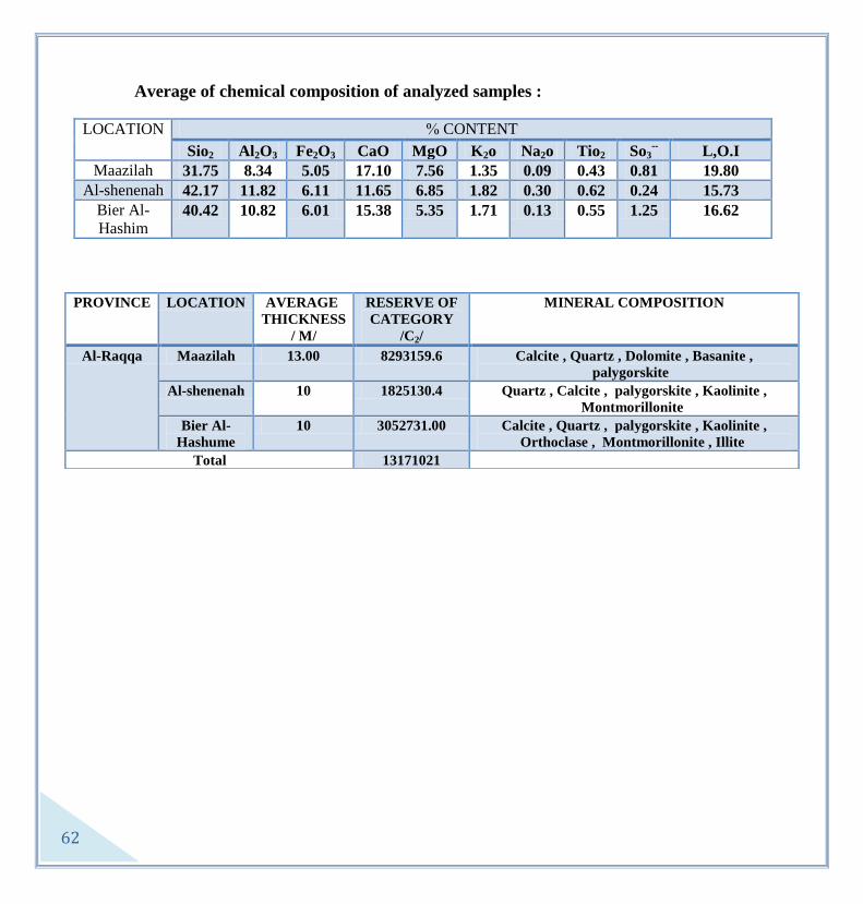
62
Average of chemical composition of analyzed samples :
LOCATION CONTENT %
Sio2 Al2O3 Fe2O3 CaO MgO K2o Na2o Tio2 So3--
L,O.I
Maazilah 31.75 8.34 5.05 17.10 7.56 1.35 0.09 0.43 0.81 19.80
Al-shenenah 42.17 11.82 6.11 11.65 6.85 1.82 0.30 0.62 0.24 15.73
Bier Al-
Hashim 40.42 10.82 6.01 15.38 5.35 1.71 0.13 0.55 1.25 16.62
PROVINCE LOCATION AVERAGE
THICKNESS
/ M/
RESERVE OF
CATEGORY
/C2/
MINERAL COMPOSITION
Al-Raqqa Maazilah 13.00 8293159.6 Calcite , Quartz , Dolomite , Basanite ,
palygorskite
Al-shenenah 10 1825130.4 Quartz , Calcite , palygorskite , Kaolinite ,
Montmorillonite
Bier Al-
Hashume
10 3052731.00 Calcite , Quartz , palygorskite , Kaolinite ,
Orthoclase , Montmorillonite , Illite
Total 13171021

63
The Raw Materials of Cement Manufacture
The manufacturing of building raw materials plays a significant role in the service of national
economy. And especially, the manufacture of cement; due to the great importance that this
material plays in meeting the needs of building and construction works for the development
projects.
The Geographic Distribution and the Quality Characteristics of Cement Raw Materials:
A group of basic raw materials: (lime stones, marly Lime stones, basalt rocks or red clay) are
used in the cement manufacture. The supplementary materials (quartz sands, gypsum,
volcanic tuff, iron), on the other hand, are added to the mixture after being grinded as
necessary.
Carbonate Rocks: They cover most of the lands of the country; they spread over vast areas in
the middle, northern and western regions, and over limited areas in the eastern and north
eastern regions of the country. These rocks appear as lime and marl formations, and in some
locations, they are characterized by their high purity.
Basalt Rocks: These rocks cover large areas of the land of the country, and they are
especially concentrated in the south of the middle region. These formations are often of big
thicknesses and they form an essential part of supply for the cement factories in the country,
instead of red clayey soil.
Silicic Sands: These formations are concentrated in the middle and southern regions (Al
Thanaia, Al Nabk, Al Qarytain, Al Tias, Al Beshry, Al Zabadani…).
Iron Ores: These raw materials are located to the north west of Aleppo in the area of Rajo
and to the north west of Damascus in the area of Zabadani and Jdaidet Yaboos.
Gypsum Rocks: These sediments are located to the north east of Damascus in the area of
Jairood, and to the east of Latakia in the areas of Kreet and Al Haffa. And they also appear
along the Euphrates Valley from Al Raqqa to Deir Al Zour then Al Bookamal, and in all the
areas located to the east of the Euphrates basin.

64
Volcanic Scoria: These rocks exist in the southern region (Al Suaida'a and south east
Damascus), and in the areas of Al Hasaka, Al Raqqa and Golan.
Basic raw materials such as lime stone, marl, basalt or laterite are used in the Portland
cement manufacture. And other supplementary materials are used as follows: quartz sand (to
modify the silicate module), gypsum (to control the timing of stiffening) - pozzolana\ volcanic
tuff (to produce high resistance cement).
Lime stone, basalt or laterite, in addition to the supplementary materials are used in the
manufacture of cement in Syria.
Cement raw materials in Syria:
Basic cement ores are (lime stone – basalt – laterite), they exist in many adjacent locations
within many areas of the lands of Syria.
The following is a chemical analysis of the carbonate rocks (lime and marly lime):
Mineral
oxides
From To
SiO2 0.46 15.73
SO3 0.05 0.12
Cl 0.01
K2O 0.10 0.6
Na2O 0.18 0.63
L . O . I 42.90 43.08
CaO 50.04 55.35
MgO 0.05 1.87
Fe2O3 0.2 1.24
Al2O3 0.4 2.23

65
A chemical analysis of the basalt rocks:
Mineral
Oxides From To
SiO2 39.94 47.83
SO3 0.01 0.31
Cl 0.01 0.05
K2O 0.54 2.26
Na2O 1.49 2.65
L . O . I 4.5 9.33
CaO 1.52 13.23
MgO 4.98 6.37
Fe2O3 0.2 1.24
Al2O3 11.41 13.58
Reserves:
Invested ores /m.t/ deposit
Ready
Extracted
Amounts
Extracted
Amounts
Available
Reserve
Studied
reserve
Potential
reserve
1129 - 1201 1413 5829 Damascus-abouAlshamat-jablAlsis
935 - 935 1100 1600 Homs-hsie-jablAlkhle
- - 255 300 600 Aleppo
- - - - 743 Palmered -Albshri
Lime stones quarries conditions:
Crystallized lime stones appear right on the surface, so that no mantle removal will be
required for the exploitation works. Besides, quarry exploitation is being done by means of
surface quarries through terraces appointed from the top and downwards.

66
Carbonate Rocks (lime - dolomite):
Carbonate rocks are sedimentary rocks, and they include lime stones which consist mostly of
calcium carbonates and of dolomite rocks that also consist of calcium and magnesium
carbonates.
Ore Distribution in Syria:
The quarries of limestone and dolomite limestone are spread over many municipalities
and areas of the country, and this is due to the fact that the rock formations, which are
suitable for the exploitation works, and which belong to different geologic ages, appear in
most of the areas of the country. Besides, it should be noted that the economic cost factor of
transporting the materials from the producing quarry to the consumption place, when it
comes to the quarry exploitation operations.

67
Dolomite limestone quarries:
These quarries produce gravels by means of grinding the dolomite lime stone which consists
upon chemical analysis of calcium and magnesium carbonates. In turn, those gravels are used
in the concrete casting operations and in road-works. However, as for the pure and clean
materials, they are used in many industries such as (glass industry and furnaces...).
Dolomite lime stone formations appear in the stratigraphic column within the deposits of the
cretaceous and the Jurassic (Cenomanian-Tornian). The thicknesses of these formations
range between 100 to 200m, and they are found in the southern, middle and coastal regions.
The geologic reserve of the detected dolomite limestone formations is estimated at about 8
billion cubic meters, and the exploited out of which is about 2 million cubic meters. The
whole geologic reserve, on the other hand, is estimated at about 50 billion cubic meters.
Limestone quarries:
These quarries produce building rocks and white sand, which is needed for covering works
and also for tiles manufacture, through exploiting and grinding the limestone which consists
of calcium carbonates. Pure and clean types, on the other hand, are used in a multiplicity of
industries: cement – carbonate powders – paints – filling substances…etc.
Limestone formations exist within the deposits of the Middle and the Upper Eocene and in
the Oligocene, and sometimes within the Neogene. The best types are within the Upper
Eocene where the carbonates percentage is about 99%. These types appear in the southern,
middle, northern and coastal regions.
The geologic reserve of the exposed limestone formation is estimated at about 12 billion cubic
meters.

68
The Results of the Laboratory Studies
Material Chemical
Analysis
Axis
pressure
Mega
Pascal
Sand
equivale
nt %
Corrosi
on %
Density
g/cc
Humidi
ty %
Porosi
ty %
Solidit
y %
Uses
CaCO3
MgCO3
Dolomite
limestone
for
grinding
95% 5% 1.45 60 24 2.53 1 2 92 Solidified and mixed
cement
"Gravels
" 54% 45% 10.38 85 16 2.77 8 5 96
Dolomite
limestone
for
grinding
90% 10% 1.62 60 24 2.53 1 2 93 Asphalt mixture of all
degrees for road-
works
"Gravels
" 54% 45% 10.38 85 16 2.77 6 5 98
Limeston
e for
grinding
90% - 0.92 55 20 2.42 1 2 91 Building rocks and
sand for covering
works and for bricks
manufacture "White
sands"
building
rocks
98% - 3.49 70 40 2.55 9 10 97
The study and development of the conditions of quarry exploitation:
Explosion methods are used in most of the quarries of the country for getting the primary
take-outs. To further process these take-outs, it means crushing and grinding in different
ways. Besides, explosion techniques depend primarily on the use of classical explosives such
as: "dynamite – niter".
The Establishment is currently trying to abolish the classical method of exploitation, which is
"caves". This method has some advantages. First, it saves a lot of explosives, and second, it
helps in getting big amounts of the take-outs easily. However, with the passing of time, the
"caves" method causes gabs and big cracks in the site and a huge and incurable deformation
to nature. Besides, this method has grave dangers caused by sudden downfalls which might
69
occur due to the forming of vertical and unstable surfaces. Addition, continual explosions
cause dislocations in the rocks.
On the other hand, the "levels method" for instance, which is one of many other alternative
technical methods for quarry exploitation, does not cause a deformation to nature. Besides, it
ensures a higher level of quarry safety because it does not involve the forming of high vertical
surfaces so that the risk of sudden downfalls could be avoided. However, this method requires
greater amounts of explosives and a higher investment capital.
The following are the steps for adapting this method:
1- Opening a primary terrace or "level" in the natural ground and leveling it to facilitate the
work of machines and vehicles.
2- Creating a suitably inclined sidelong road for the vehicles to get to, for opening the "level"
where the take-outs have to be extracted, and which is from 10 to 15 meters higher from the
primary one, depending on the nature of the rock and the quarry.
3- Creating a certain number of bores, (the diameter of each is about 10 cm, using a
pneumatic drill with a suitable distribution according to the nature of the rock with the
required depth), in this second "level" from which the take-outs will be extracted later on.
4- For executing the explosion in due time, those bores are to be filled with explosives, which
are connected by a triggered fuse or a normal one as available.
5- After the explosion the remains are thrown down by the bulldozer to the primary "level".
6- The residues from the above mentioned level are carried by trucks to be transferred to the
cracker.
7- The work within the mentioned level carries on until there's no difference in the grades of
the two levels, while maintaining a suitable inclination for the formed surfaces between the
two levels.
8- A new level is created for the work to continue, after providing a side road with a suitable
inclination to reach it. The work carries on in the same above mentioned way.

71
In case these quarries are to be exploited as groups, then each group could form an internal
road network and side roads to reach the levels, provided the nature of the sites allows it.
For ensuring the continuity of work, and that the workers and the machines are not
hampered, the work could be distributed within the front of a quarry, and could be done at
the same time, according to the following:
1- Drilling wells with proper heights and preparing them for the explosion.
2- Removing the residues of the explosion by the bulldozers to the lower level.
For handling the big rocks, which are bigger than the size of the lifter, they are often removed
out of the site. With the passing of time, these rocks form big piles which occupy wide spaces.
Recently however, these rocks could be exploited through fragmentizing using compressors.
However, these big rocks are rarely found within the residues of the explosion in case the
method of the levels was adapted.
The following are some necessary procedures that have to be taken in order to move the
exploitation from the classic method to the technical one:
1- Removing the noticed dangerous surfaces and the vertical heights which form a grave risk
to the workers as well as to the machines, and this could be done through executing the
explosion via bores from above.
2- Carrying out a huge explosion or many explosions and piling the residues in the ground to
gradually reduce the vertical heights and making levels out of them. The height of each level
should be from 10 to 15 meters according to the nature of the rock and to their number
considering the height of the site front.
3- Creating side roads for the vehicles to reach up.
4- Entirely eliminating the classic method of explosion "caves", and starting the exploitation
from the top "level", which is done through bores.
The technical characteristics of the Raw Material:
Limestone: An organic rock crystallized or non-crystallized and it has a wide range
toughness-wise. White, beige and pink are the colors of this rock and that is according to the
degree of its purity where there might be impure materials in it. It basically consists of calcite
71
and lime detritus with a lesser degree of clay, dolomite and quartz silt. In these rocks, the
percentage of calcium carbonates ranges between 75 – 98 %.
Dolomite Rocks: tough, crystallized and moderately compact or sometimes it comes in masses
and other times it is loose. The dolomite rocks toughness ranges between 3.5-4, and its density
is between 2.8 – 2.9 and it also has porosity and a high percentage of cracks, it also has a lot of
cavities. MgO percentage is between 14 – 21%. CaCo3 is between 22 – 30%. Dolomite rocks
can calcite when heated to about 1800 degrees Celsius. Considering its purity as well as its
physical specifications, the best sites where these rocks can be found is the countryside of
Damascus (Hafeer – Al-Dmair) and in Homs (Hessia).
Ore Mining:
In many places, these rocks appear on the surface and they are extracted, from exposed
quarries, by both of the investment sectors: the private and the public, as raw materials for
cement manufacture or for decoration stones (similar to marble) and building materials for
casting works.
Possible Utilizations:
1- In Building and Manufacture:
A- Limestone:
- In building works (building substances, building rocks, lime ore, Portland cement,
sandy lime bricks).
- In chemical manufactures (carbide, sodium carbonates, calcium chloride, mining
colorful metals, pastes, paints, glass, porcelain, ceramics and paper).
- In agriculture (soil acidity moderation, fodder mixtures).
B- Dolomite rock:
- It is used in building works as a primary substance for the manufacture of cement of
all sorts.
- Manufactures could use dolomite to produce: fiery bricks, glass, solvent substances
that can be used to melt iron, magnesium compacts.

72
Rock Salt
Na Cl is the Chemical formula of the compact “salt”; sodium chloride or halite. The
percentages of its components are: Na: 39.34%, Cl: 60.66%. Crystals of salt are
transparent, colorless and scentless; they are salty but not bitter. They feel dry and they slip
easily. The diameter of a grain of the normal food salt does not exceed 1mm. Addition, when
solved in water, they weigh 10%.
According to the adapted specifications, food salt falls into two categories: first, table salt
where Na Cl minimal percentage is 98.5%, second, normal table salt where Na Cl minimal
percentage is 97.5%. Besides, food salt should be free of toxics like arsenic, copper and lead.
The maximal reasonable percentage should not exceed two grams per ton.

73
Ore Locations in Syria:
Large amounts of salt rock are available in the lands of the country, and they spread
widely in the Euphrates depression and in the north east of Syria. They form a single local
deposit, or many ones which vary in thickness between few meters to tens of meters like in
the Euphrates depression (Al-Harmoushiah – Al-Teeny – Me'adan), whereas the thicknesses
of the local deposits vary between tens of meters to hundreds of meters as is the case with
the salt deposits of Al-Deebaneh. The studied reserve of the feasible deposits in the area of
Al-Harmoushiah alone, according to the Russian studies and those of the establishment,
reaches well over 900 million tons. Add to that the availability of the annually renewed
amounts of salt which is produced by the salinas of Al-Bawara, Al-Jabool, Palmyra, Al-
Jbaiseh and many others. However, the production rate of those salinas is affected by the
annual degrees of rainfall.
Al-Tebny Mine:
It is located at a distance of 40 km to the west of Deir Al-Zour, on the west bank of the
Euphrates. The site is 100 meters above the river level and 300 meters above the sea level,
where as the depth of the salt layer is 150 m.
The deposit goes back to the age of the Neogene - Middle Miocene - the Lower Fares
formation. The thickness of the deposit varies between 3 to 6 meters. According to the
former Russian studies, the reserve of both degrees B + C1 reached 19 million tons. As a
result of the works of the Establishment in the years 95 -96, on the other hand, a new
reserve of both of the degrees B + C1, about 27,16 million tons was added, so that the total
reserve is 46 million tons, with 98.97% as an average content of sodium chloride.
Al-Harmoushia Salt:
The rock salt deposits lie within the Lower Fares formation, and the upper layer exists
only on the east bank of the Euphrates and it occupies about 16 km2
of the studied area,
whereas the lower salt layer spreads on both of the banks of the river over an area of 30
km2. Two deposits of rock salt, from the lower part of the formation, were identified and
studied; separated by an alternation of clay and anhydrite, with an average about 34 meters

74
of thickness. The average thicknesses of both the upper and the lower deposits are
consecutively 10.06 m and 10.84 m. The average thickness of the mantle of the upper deposit
is 160 m, whereas the average thickness of the mantle of the lower deposit is 204 m.
Laboratory analysis results show that the rock salt samples are of good purity. It also
shows that the content of sodium chloride for the upper deposit is 97.4% and 96% for the
lower deposit. The reserve of salt in Al-Harmoushia was calculated for an area of 102 km.
The total reserve is 421 million tons of the grades (A+C1+C2), and the exploitable out of
which is 336 million tons, with an average content of sodium chloride between 98.3-99.30%.
The available amounts of salt in Al-Harmoushia deposit, within the geologic conditions,
and its high quality specifications, represent a huge strategic deposit of salt. Actually, this
deposit is the most important salt deposit in Syria; for its deployment in the economic
exploitation and its use in the fields of consumption, industry and export. Besides, the area
has a lot of suitable geographic as well as environmental conditions. For example, it has a
main land road and a rail road connecting it with the other municipalities in the country,
and the high voltage line passes through it, and although, it is located near the Euphrates
River, it is unexploited agriculturally, besides, it is uninhabited. Environmentally speaking,
the area has great environmental advantages because it is not polluted.
Conclusion, an availability of exploitation options, as to either use the mines method or the
dissolving one, is allowed due to the geological circumstances and the high quality
specifications that Al-Harmoushia site has. And this is to be decided according to the results
of the feasibility study; the decision falls upon the method that is less expensive.
Other salt deposits:
Mining works for petroleum, sulfur and salt referred to the fact that huge salt deposits are
spread over wide areas in the north east of Syria and the Euphrates depression, and they go
back to the Bordigalian (Al-Deebaneh Formation) and the Tortonian (The Lower Fares
Formation).

75
Depths and thicknesses of Salt Deposits in the north eastern region of Syria
Area Site Depth average of the
Upper surface
Thickness average
Al-Jubaiseh - Al-
Salehieh
60 km south east of
Al-Hassaka
565 - 755 50 - 180
Qubaibeh 15 km south of
Jubaiseh
835 - 1150 195 - 275
Gohneh - Al-Hasso 8 km north of
Jubaiseh
575 - 940 170 – 230
Jumbah - West
Teshrene
35 km south east of
Al-Hassaka
350 - 365 65 – 130
Al-Hawl 45 km east of Al-
Hassaka
350 - 450 200 – 300
Sheikh Suleiman -
Sheikh Mansour
To the south and the
east of Al-Hassaka
465 - 670 75 - 115
The salt of the Salinas:
There are surface resources of salt, and these are natural aquariums where the water of
streams and winter rains gather in them. A salt residue, with thicknesses relative to the level
of water that gathered in the salinas in winter, remains due to the availability of suitable
evaporating conditions. See the table of Salinas Distribution in Syria.
These salinas are spread over many areas of the lands of the country, and the most
important out of which are:
The Salina of Al-Bawara:
It is located at the borders of Syria and Iraq and distributed evenly between the lands of
both of the countries. Al-Bawara Salina occupies in Syria in the municipality of Deir Al-
Zour an area of 11km2. The average of its annual production, in the rainy seasons, is about
40 000 tons of salt. Besides, not only the area is uninhabited and there are not much of
neither agricultural nor industrial activities going on in there, but also the plants are rare.

76
Al-Jabool Salina:
It is located in the south of Aleppo. Precipitation aquariums were equipped in there over
an area of 24 hectare to increase the concentration of the water of the natural precipitation
aquariums. The average of its annual production reached 15 000 tons.
Al Jebseh Salina:
It is located in the south of Al-Hassaka, near the petroleum fields of Al-Jebseh, and it
occupies an area of 4 km2. It is fed by the water of a salty stream. The average of its annual
production is 5000 tons.
The Salina of Palmyra:
It is located in the south of Palmyra; it is specified to produce industrial salt when needed.
Utilisations:
1- Rock salt is used to produce table salt, and also in food reservation.
2- It can be used in chemical industries such as: paper, sugar, fertilizers, detersives,
explosives, soda, sodium carbonates, sodium sulfates and any other industries that contain
sodium compounds.
3- A supplementary material to fodder.

77
Zeolite
One of a large group of amorphous hydrated aluminum silicate minerals that may also
contain sodium, calcium, barium, and potassium, and the known out of which are 40
minerals, but the feasible ones do not go over 7. It is porous, capillary and joint in structure,
which gives it unique reciprocity and adsorption properties.
Ore distribution in Syria:
Ores are located in the south eastern regions of the country, and specifically along the
contiguity between Al-Ratba plateau in the east and the eastern ends of depression of the
igneous Al-Arab Mountain in the west. Three main areas could be specified: Al-Siss
Mountain, Omm Othen and Mukeihlat.

78
Al-Siss Mountain:
It is located to the south east of Damascus, about 170 km, and it could be reached by the
main road of Damascus – Al-Dmair Al-Sabe'a Abiar subway.
The area is about 8 km2 and in definition; it is lands that consist of a group of little
depressions, basalt hills and a main hill which is Al-Siss that is 699 meters above the sea
level. Generally, the area is steep due to the basalt steeps, and to the north of it appears a
volcanic cone called Al-Makhool which its topographic height is 749 meters. The petro-
clastic – sedimentary accumulations give the body of Al-Siss Cone the shape of levels and
consecutive layers, which incline starting from the body of the cone to the ends with a 45º
angle. These inclinations decrease towards the ends till the little depressions surrounding
the cone where they become semi horizontal. The outcropped thickness of these deposits is
80 meters. The thickness of the tuff rock which carries the Zeolite, in the mining area,
ranges between 9 – 66.5 meters in the area of the reserve b, while in the area of the reserve
C1, it ranges between 3 – 38 meters; and the average is 18 meters.
The assured reserve from the grades B, C1 of the tuff rocks which carry the Zeolite is
234.35 million tons.
Al-Mukeihlat Hills:
It is located to the east of Damascus, about 170 km. The deposits of tuff which carry the
zeolite are outcropped in the area of the Mukeihlat Cones which is about 2.8 km2. Most of
the deposits are outcropped on the hills and a part of which is covered by recent marine
deposits. The thickness of these deposits is somewhere between 10 and 160 meters.
These deposits consist of many levels; their thicknesses vary from 3 to 5 cm. Each of them,
in turn, consists of petro-clastic substances and most of them are like knots over the basis of
the structure. These knots are transferred and they consist of forsterite, ortho-peroxine,
amphibole and plagioclase. And sometimes, they consist of volcanic ash within a cement
which consists of clays and zeolite minerals. The percentage of the petro-clastic substances is
about 50% of the general constituents of the rock. However, some levels show that the
percentage rises up to 70 %, and in other levels it gets down to about 30%. Besides, these

79
deposits contain sediments and impulsive blocks that are transferred with scales that range
from 2 to 50 cm.
The hill of Omm Athen:
It is located within Tal Al-Najaar Sheet, scale 1/50 000, to the south east of Damascus
about 220 km, and it can be reached via the main asphalt road of Damascus – Al-Dmair –
Al-Butmiat (Al-Sabe'a Biar subway). The area of Tal Al-Najaar is 650 km2, and the area
that contains the petro-clastic lies within the Omm Athen group of cones and the
surrounding little depressions with a total area of 22 km2. The area is flat topographically
with a light inclination to the west and the south west. Addition, the highest topographical
point in the Omm Athen Cone is 690 meters and the lowest one represents the spread out
little depressions 600 meters. The average thickness of the tuff which carries the zeolite is
27.5 m.
The results of the chemical analysis
L. I
TIO2
MGO
FE2O3
K2O
NA2O
CAO
AL2O3
SIO2
OXIDE
SITE
14.7 1.92 7.64 10.78 0.9 0.9 10.69 12.25 38.11 Al Siss
15.27 1.62 7.45 9.88 1.05 1.18 14.04 10.69 34.46 Al Mukaihlat
14 2 6 12 1 1 12 18 36 Omm A'then
Ore specifications:
A Zeolite volcanic tuff that consists of basalt pieces cemented by a volcanic glass, which
in turn is transformed into a multiplicity of zeolite ores, and sometimes into
montmorillonite.
Physical properties: The raw material consists of the following zeolite ores: philipsite,
analcime, shpazite, harshlite, and also other volcanic ores like oliphine, anstatite, lucite,
anortite and pyroxene, in addition to the sedimentary ores, montmorillonite, calcite and
quartz. The percentage of zeolite in the rock ranges between 30-50 %. Zeolite has high

81
absorption – adsorption properties for water and ammonium evaporates and also it has
active ion reciprocity.
Mining method:
The ore could be extracted via surface quarries. For the purpose of preparing this
substance for exploitation, a study, enrichment and improvisation of the ore quality tests are
being carried out currently.
Possible utilizations:
Zeolite ores can be used in qualitative as well as very important fields:
1-Agriculture: soil improvement, organizing water consumption, a supplementary
material for many different fertilizers and for fodder mixtures and cleaning stables.
2- Industry: liquids purification, drying natural gas, a filling substance in the detergents,
glass, pottery and porcelain.
3- Environmental usages: fresh and salt water purification and also the purification of
organic compounds and toxic and pollutant mineral ions.

81
Iron
In definition, Sedimentary rocks placed in a marine environment at a depth of 50 – 100 m,
these rocks consist of malleable solvents rich with iron compounds salts which are transferred
from the resultants of volcanic rocks corrosion and fragments, and they take the shape of
oolitic and beziolitic iron ore, and they are stained with quartz sands and carbonates.
Nowadays, where iron is used for a variety of engineering and structural products, it is
considered the primary pillar on which the heavy industries are based. Besides, the iron and
steel industry and the industries which depend on it, are considered the basis for industry
development in general. It is the fourth most abundant element in the earth’s crust and is
believed to make up 80 percent of the planet’s core; it is found in more than 350 ores.

82
Ore locations:
The ore exists in many areas; the coastal region (Al-Qadmus), the southern region (Al-
Zabadany) and the northern region (Rajo), and the most important areas of which are three:
- Al-Zabadany: 50 km north west of Damascus
- Al-Kurdagh: 80 km north west of Aleppo
- Al-Qadmus: 70 km west of Hamma
There are four primary kinds of iron ores:
A- Oolitic: this type is one of the most important iron ores in Syria, and the upper Apsian
formation in the area of Al-Zabadany is the primary formation which carries this type of iron
ore. It also exists in the area of Al-Qadmus whereas in the area of Al-kurdagh, it is noticed
but with a lesser percentage. This type is characterized by its oolite grains which their
diameter reaches to 2 mm, cemented by iron, clay or carbonates. An oolite grain nucleus often
consists of debris quartz and sometimes of glaoconite, whereas the grains basically consist of
goethite and hydro-goethite and it is characterized by its zonal structure. The average of iron
percentage in this type reaches up to 34%.
B- Beziolitic: it is considered the most spread of types in the Syrian iron ores. The lower
Apsian formation carries this type in the area of Al-Zabadany, and it is also noticed in the
areas of Al-Kurdagh and Al-Qadmus, however, in these two areas it doesn't form an
independent level but its shape is more like a convergence with the other types.
The diameter of beziolite grains ranges between 2 and 10 mm gathered by sand, clay and iron
cement. And it is noticed sometimes that the beziolite grains contain a number of oolite grains
and sometimes they contain debris quartz. An abundance of rutile and ilmenite is also noticed

83
so that the percentage of titanium in this type is high. Beziolite consists of goethite, hydro-
goethite, hematite and hydro-hematite. The percentage of iron in this type is over 30%.
C- Conglomeratic: this type exists abundantly in the areas of Al-Qadmus and Al-Kurdagh,
and it consists mainly of angular or round debris with scales of 0.5 to 1 cm, gathered by clay
and iron and sometimes carbonates cement. The percentages of hematite, hydro-hematite and
titanium are noticeably higher in this type. And the average of iron percentage here is 34%.
D- Iron rock sand: this kind is widely spread in the areas of Al-Qadmus and Al-Kurdagh, also
in the lower Apsian formation in the area of Al-Zabadany, and also in the thin layers of rock
sand which separate the oolitic layers within the upper formation.
This kind consists of little grains of quartz; their scales do not go over 2 mm, and they are
often gathered by iron cement. The percentage of iron in this kind is 18-25 %.
The Syrian iron ores are generally characterized by their low percentage of iron; it ranges
between 28 to 34 %, and the average of iron percentage in any of the deposits differs
according to many criteria of which are the following:
- Reserve calculation degree, the minimum percentage of iron in the ore, the thickness of the
in-between layers, the minimum thickness of the layers that can possibly be extracted, the
amount of the exploitable reserve and the method of the exploitation…etc.

84
The average chemical composition of iron ores in Al-Zabadany, Al-Kurdagh, Al-Qadmus
Area Site Content %
Fe Sio2 AL2O3 CaO MgO TiO2 P2O5 S
Al-
Zabadany
Jdaidet
Yaboos
31.58 14.21 4.69 13.56 2.47 0.27 1.09 0.08
Al-
Rouda
28.54 17.04 4.39 14.66 2.27 0.60 0.93 0.05
Al-
Kurdagh
Rajo 31.8 18 15 3.69 1.63 4.14 0.37 0.06
Al-Qadmus 30 25 7.1 1.43 2.11 2.01 0.17 0.04
Al-Kurdagh:
It is located north west of Aleppo, at a distance of 80 km. the studies executed by the Russian
experts in the period between 1959 - 1961 shows that the iron deposits in this area appear in
many sites: (Kiery – Othmanly – Wadi Al-Nashab…, etc). And the iron ores reserve in the
areas of Rajo, Kiery and Elemdar was estimated at about 62 million tons with an average
percentage of iron that ranges between 30 and 32%.
The iron ore in the area of Rajo forms a layer of the Apsian column sediments which is spread
incompatibly over the Jurassic rocks. Besides, the areas carrying these ores are structurally
complicated; they consist of complex concaves and convexes with more tectonic dislocations
and more faults different in intensity, age and direction.
The thickness of the Apsian in the area of Rajo ranges between 10-60 m, and it sometimes
goes up in some other locations. Whereas the thickness of the iron ore in Rajo is 10 m, and it
consists of the Alpian deposits which are characterized by their carbonates. The
conglomeratic iron ore is the prevalent type in the deposits of Rajo and Elmdar. Other ores

85
like oolitic and beziolitic are noticed, but with lesser percentages. The hematite and hydro-
hematite ores are abundant in it, besides the alumina, titanium and phosphor splotches are
also plentiful.
Back in 1962 the soviet experts executed 6021 focalization experiments on these ores, and the
results showed that they can be industrialized using the known methods at that time. The
Korean experts on the other hand also executed focalization experiments on a sample which
weighs 25 tons of these ores, and the results were similar to the previous ones. The
Establishment has been carrying out works and geologic studies since 1996 in the area of
Rajo, aiming to reach for new detailed and specific results.
Al-Qadmus:
Iron deposits are outcropped in many sites west and south west of Al-Qadmus, located in the
middle of the road connecting between Banias and Messiaf. The area goes back to the Apsian
which its sediments in the area consist of clayey and distinguished green marly rocks, sand,
iron, calcium and chalk rocks, with a thickness that ranges between 20 and 40 cm. Iron ores
form a layer which varies in quality and in thickness in the base of these sediments, and they
are characterized by quick Lithological changes in both horizontal and vertical directions and
also by the gradual change from kind to another of ores or to rocks low in iron content, so
that the thickness of the ore changes accordingly from 0.5 to 6 m.
The studies of the chemical and mineralogical composition and the structural properties of
these ores indicate that they are mainly of the following kinds: conglomeratic, oolitic and iron
sand rock. And the most important iron minerals that distinguish these ores are goethite,
hydro- goethite and hematite. The average percentage of these ores ranges between 28-32%.
Addition, these ores are characterized by their high titanium percentage where the average is

86
between 2-3%. The reserve in two sites of the area, Al-Maula Hassan Mountain and Al-
Tuffaha was estimated in 1977 at 15 million tons.
Al-Zabadany:
Surveys and geologic excavations in Al-Zabadany proved that there are many kinds of iron
ores which form independent bedded levels, distinct within the sediments of the Apsian. The
oolitic is the best and most important of these ores because of its relatively good quality and it
is also widespread in the area. It was possible to locate six sites where this ore is deposited in
the area as a result of the geologic field studies which were executed in the period between
1980-1970. In those studies the primary and the detailed geologic excavation works were
executed for the following sites: Jdaidet Yaboos, Al-Rawda, North of Al-Zabadany, Yaboos –
Ateeb, Deir Al-Asha'er and North of Bloudan.
In what follows we will tackle the most important results of the executed geologic excavation
works in these sites, and also the most important geologic and qualitative properties of the
deposited ores.
Jdaidet Yaboos Deposit:
It is located 25 km to the south of Al-Zabadany, near the Lebanese – Syrian borders. The
geologic excavation works executed in this area since 1970, focused on the deposits of the
oolitic iron ores which are located within the sediments of the Upper Apsian formation,
because they are thick, widespread and rich in iron when compared with the beziolitic iron
ores which are located within the lower formation of the Apsian in the area.
The Upper formation can be divided into three levels:

87
A- The lower level: it consist of 1-4 layers of iron ore with a /2.6 m/ total average thickness,
intercalated with layers of clay and marl.
B- The separating level: it consists of fossilized lime stone which contains some oolite grains
and thin layers of clay, and its average thickness is 1.7 m.
C- The upper level: it consists of many, 1-8 layers, of oolitic iron with 5.6 m as the total
average thickness, intercalated with layers of marl, clay and lime stone.
The primary excavation works executed in this site, by the local expertise, included a
geologic map with a scale of 1/5000. Besides, the iron ore reserve was calculated 65.5 million
tons from the grades B + C1, and the average percentage of iron is 34.7%. Addition, only the
layers of iron from each level, with 20 % as a minimum percentage, was counted in the input
of the calculation process. And the reserve which falls under a mantle that ranges in
thickness between /0 and 50 m/, was estimated at about 11 million tons.
Intercalated
layer
thickness
0 m 0.2 m 0.5 m 0.8 m 1 m
Grade Reserve Fe% Reserve Fe% Reserve Fe% Reserve Fe% Reserve Fe%
B 28.49 31.58 28.65 31.47 30.61 30.12 32.96 28.73 34.77 27.79
C1 44.23 29.97 44.94 29.85 46.93 28.92 50.91 27.71 53.01 26.89
C2 31.85 29.68 32.31 29.64 34.14 28.33 37.76 26.71 39.79 25.89
104.56 30.32 105.50 30.17 111.68 29.07 121.63 27.63 127.56 26.82

88
Al-Rawda deposit:
It is located at 10 km to the south of Jdaidet Yaboos. Some geologic excavation works were
executed in this site; Korean experts contributed, in cooperation with the Syrians, in the
production of the geologic map, scale 1/10 000. In 1977 the establishment continued the
geologic excavation works in this site which stretches on a distance of 4.4 km and the digging
of ten automatic wells. In comparison it turns out that there is a great resemblance, in both
stratigraphic and mineralogical fields, between the ore layers in this site and those in Jdaidet
Yaboos.
Intercalated
layer
thickness
0 m 0.2 m 0.5 m 0.8 m 1 m
Grade Reserve Fe% Reserve Fe% Reserve Fe% Reserve Fe% Reserve Fe%
B 12.27 28.54 12.33 28.43 12.74 27.76 14.01 26.05 15.17 24.64
C1 3.46 27.27 3.46 27.27 3.53 26.92 2.82 25.39 4.08 24.21
C2 1.58 28.21 1.58 28.11 1.67 27.11 1.73 25.26 1.53 25.02
17.30 28.25 17.37 28.16 17.94 27.54 19.56 25.85 20.78 24.59
Estimated Reserve:
1- The southern region:
A- Jdaidet Yaboos: The whole reserve of all grades is 105 million tons.
B- North of Bloudan and Al-Rawda: the reserve of all grades is about 200 million tons.
2- The northern region:
A- Rajo – Elmdar – Kree: 61 million tons.
B- North of Rajo (chadeliany – Al-Mazra'a - Midaneliat): 18 million tons.

89
Mining method:
The iron ores in both sites are of the low grade sedimentary type.
Jdaidet Yaboos: the iron ore can be excavated via open quarries, about 50 million tons,
with a size constant 1/20. The layers inclination is between 15-20 degrees.
North of Bloudan: 100 million tons can be extracted via open quarries as well.
Rajo: the ore layers are deposited with a relatively high inclination (more than 30
degrees), and possibly are disjointed tectonically; parts of which can possibly be extracted
via open quarries.
In 1980 experiments were executed to enrich the ore and mine it by the high temperature
furnace, and there is a probability of manufacturing the iron ores of Al-Zabadany by mixing
it with an imported rich iron ore (40 %).
Possible Industrial Utilizations:
1- All types of Iron and steel manufactures.
2- A supplementary material in cement industry.
3- Ferrous pigments production.

91
Tripoli
(SiO2): A Light porous siliceous sedimentary rock, of finely grained constituents, very slight
to microscopic crystallization, deposited in an average depth marine environment.
Ore location:
Tripoli spreads on a wide range within the lands of the Upper Cretaceous (Maastricht), in
the northern and southern Tadmurīyah mountain chain, the most important sites are:

91
Al- Tadmurīyah: North of Ghadeer Al-Hamal and north of Al-Sawaneh Alhamraa
(between Khnefees and Al-Sawaneh), the deposits belong to the upper cretaceous
(Santonian): A- North of Al-Sawaneh Alhamraa: the thickness of tripoli deposit is between
2-5 meters; 3 meters is the average thickness. B- North of Ghadeer Al-Hamal: the thickness
of the formations which carries tripoli ranges between 6-8 meters, and the average
thickness of tripoli deposits is 4 meters.
Estimated Reserve:
North of Al-Sawaneh Alhamraa: about 300 thousand tons of the B grade.
North of Gadeer Al-Hamal: about 700 thousand tons of both B+C1 grades.
Ore specifications:
It is similar to chalk shape-wise, while it has the hardness of quarts. The percentage of SiO2 in
the ore ranges between 65-95%, and that of calcium is between 0.14 - 17.8 percent. The
qualitative weight ranges between 2.15 – 2.62 %. And the volumetric weight is 1.5 g/cm3.
Tripoli has good absorption properties; somewhere between 50.71 % and 53.14 % is the
degree of oil absorption, and that of water is about 38 %.
Ore mining:

92
The layer thickness is between 50 cm and 5 m, with an average thickness about 3 meters.
It could be exploited via open mines with low expenses.
Possible Industrial Utilizations:
It can be used in paints manufacture (filling substances), cement manufacture,
insecticides, juices purification, make-ups, medicines, rubber, chemicals, heat separation,
detergents, polishing substances and light bricks.

93
THE GENERAL ESTABLISHMENT
OF GEOLOGY AND MINERAL RESOURCES
Damascus - Adaoui
7774444 - 7744444Tel:
7794674Fax:
4974P.O BOX:
E_Mail: geo @ geology – sy.org
Web: www.geology.sy.org
GEN. COM. PHOSPHATE MINES
HOMS – ROAD – PALMERA
Tel:651124 – 65122
Fax:651123
PO.Box:288
www. Gecopham.com
E_Mail:[email protected]