the geology of the beruk northeast field, central sumatra...
TRANSCRIPT

PROCEEDINGS INDONESIAN PETROUXJM ASSOCIATION Thirteenth Annual Convention, May 1984
THE GEOLOGY OF THE BERUK NORTHEAST FIELD, CENTRAL SUMATRA: OIL PRODUCTION FROM PRE-TERTIARY BASEMENT ROCKS
T. KO** F.X. Dannono*
ABSTRACT The Beruk Northeast oil field in Central Sumatra was
discovered in 1976 by the drilling of Beruk Northeast No. 1 which tested 1680 BOPD from Pre-Tertiary basement. In addition to Beruk Northeast only four other fields are reported to produce oil from Pre-Tertiary basement in Indo- nesia. Indeed oil production from Pre-Tertiary rocks is very exceptional in Southeast Asia.
Oil production in Beruk Northeast is obtained from fractured metaquartzites, weathered argillites, and weather- ed granite. The basement reservoirs have K/Ar radiometric dates varying from Early Permian to Early Cretaceous ages which indicate a complex Pre-Tertiary geologic history.
The B e d Northeast No. 1 well has produced in excess of one million barrels of oil to date. Subsequent develop- ment wells have been less productive due to problems of reservoir, separate oil-water contacts and possible unrecog- nized fracture systems. Beruk Northeast serves as a re- minder that the Pre-Tertiary basement is a valid exploration objective in Southeast Asia and that whenever feasible, all exploratory wells should be drilled into basement.
INTRODUCTION The Beruk Northeast oil field is located within the Cen-
tral Sumatra Back Arc Basin, which is one of a series of Ter- tiary basins oriented along the western and southern margin of the Sunda Craton of southwestern Southeast Asia (Figure 1). The Beruk Northeast field is situated within a group of oilfields in the central area of the Pertami- na-Calasiatic-Topco Coastal Plains-Pekanbaru Production Sharing Block. The field was discovered in 1976 by the drilling of Beruk Northeast No. 1 which tested oil from fractured Pre-Tertiary metaquartzite basement rocks.
DEFINITION OF BASEMENT ROCKS The term "basement rocks" generates a variety of de-
finitions by geologists depending on the specific sedi- mentary basin discussed as well as the individual's experien- ce in that area. Most workers consider basement as any metamorphic or igneous rocks (regardless of age) which are unconformably overlain by a sedimentary sequence. Oil
may have migrated into older porous metamorphic or igneous rocks thereby forming a basement reservoir. How- ever, in some basins as the Central Sumatra Basin, the base- ment rocks may be partially or completely unmetamor- phosed. Therefore the authors of this paper prefer the Landes et al (1960, p. 1682) description of basement, as stated: "The only major difference between basement rock and overlying sedimentary rock oil deposits is that in the forxper case the original oil-yielding formation (source rock) can not underlie the reservoir". A final comment on the definition of basement rocks is -that further exploration, geological and geochemical studies in a specific area may result in revisions of the commonly accepted definition of basement rocks within that area. Further exploration may indeed prove the e&ence of hydrocarbon source rocks located stratigraphically within rocks previoudy regarded as basement. Accordingly explorationists' definition of basement rocks can not be rigid but must be responsive to new geological ideas and data.
AREAS OF BASEMENT OIL PRODUCnON Basement rocks are important oil reservoirs in various
areas of the world. Basement reservoirs occur in Venezuela and Brazil in South America; Libya, Algeria, Morocco, and Egypt in North Africa; the Cuanza basin of Angola in West Africa, and the West Siberia basin of the Soviet Union (Chung-Hsiang P'an, 1982). In the United States, basement- derived oil production occurs in a number of areas, including California (Wilmington and Edison Fields), Kansas (El Do- rado and Orth Fields), and Texas (Apco Field).
East Asia had no significant basement hydrocarbon pro- duction until the discovery in 1959 of oil in fractured meta- morphic rocks of Silurian age in the Y a e d Field, Yumen, China (Chung-Hsiang P'an, 1982). During the 1979's about 20 prolific basement reServOirs were discovered in the Bohai Bay basin, offshore China. Production is from Paleozoic and Proterozoic limestones in structures commonly known as "buried hills" Cyan Dunshi and Zhai Guangming, 1980). Paleocene black shales are the reported oil source rocks for the Bohai Bay reservoirs (Li Guoyu, 1981).
Almost all presently known oil and gas fields in Southeast Asia are located in Tertiary sediments. In most cases, the
* FT Caltex Pacific Indonesia oil and gas accumulations occur in Neogene age formations
© IPA, 2006 - 13th Annual Convention Proceedings, 1984
386
(Fontaine and Mainguy, 1982). In Southeast Asia rocks of Pa-Tertiary age are genedy regarded by explorationists 'as economic basement. Although the Pre-Tertiary series produces signGcant volumes of oil and gas in Australia and in China, the area in between these two continents has almost been devoid of production from the Pre-Tertiary. Severe tectonism and deformation experienced by Southeast Asia prior to deposition of the Tertiary has decreased the prospectiveness of the Pre-Tertiary series and in many areas the Pre-Tertkuy is thermally ovennature for oil preservation.
The poor production history of the Pre-Tertiary in Southeast Asia must also be partially attributed to the absence of exploration specifidly aimed towards evaluating the fie-Tertiary's potential. In this regards, the very recent discoveries of gas in he-Tertiary rocks in northeast Thailand is sig&cant. A gas flow rate of 27 MMCFD was reported from Permian limestones in the Esso Nam Phong and Chonnabot wells. These gas discoveries are in a large basin that has experienced minimal drilling to date (Oil & Gas J o d , 1982).
Basement 04 Occurrences m Indonesia
In addition to Beruk Northeast, four other Indonesian oil fields produce from Pre-Tertiary basement rocks (Figure 2). The following occurrences of basement oil production have been reported in the literature: 1.
2.
3.
4.
The Kluang Field in South Sumatra has produced oil from Re-Tertiary rocks and from the Tertiary Talang Akar Formation (Martin, 1952). OiI occurs at the top of the Pre-Tertiary in a limestone paleotopographic high similar to the Chinese "buried hills". Severe weathering prior to deposition of the Tertiary resulted in excellent secondary porosity. The amount of oil produced from basement is not reported. In the Sei Teras Field, South Sumatra, 15,000 barrels oil and 1 BCF gas has been produced since 1977 in two wells from basement limestone and quartzite (Tiwar and Taxuno, 1979). Approximately 21 million barrels of oil and 14 BCF of gas has been produced from Pre-Tertiary rocks in the Tanjung Field, South Kalimantan (Tiwar and Taruno, 1979). The basement rocks in this field consist of por- phyritic extrusives and volcanics as well as metamor- phosed sandstones, shales and claystones. In both the Sei Teras and Tanjung Fields the basement is locally deeply weathered and fractured. Mid-Tertiary sediments are regarded as the likely source rocks for both fields.
Ln eastern Seram oil is produced from Pleistocene sedi- ments and fractured basement (Bula Field), Pre-Tertiary limestone (NKf pool) and he-Tertiary sandstone and siltstone(Belienpoo1). Zillmanand Paten(1975) regarded the Tertiar! as the likely source for the Seram oils whereas Fontaine and Mainguy (1982) have suggested
the %ram oils are probably derived from Triassic source rocks. Due to the paucity of basement oil production in South-
east Asia, the Beruk Northeast oil field will hopefully be of interest t o the petroleum industry and the earth science community in Indonesia and Southeast Asia.
REGIONAL GEOLOGICAL SE"G "he Beruk Northeast fieId is located 60 km east of the
Mnas field in the Calasiatic and Topco Coastal Plains Pro- duction Sharing Contract Area which is operated by PT Caltex Pacific Indonesia. Fourteen oil fields have been dis- covered in the contract area since 1971 (Figure 3,4). All fields in the Coastal Plains produce from Sihapas sandstones and conglomerates except the Beruk Northeast field which produces from fractured metaquartzite, weathered granite, and weathered metasediments. Beruk Northeast is the o d y field yithin Caltex's area of operations in Central Sumatra which produces oil from basement.
Regional Tertiary Stratigraphy
Tertiary sedimentation in the Coastal Rains area commenced in Paleogenetjme with the deposition of Pematang Formation sediments on the Pre-Tertiary ero- sional surface. A stratigraphic cobmn is included for re- ference (Figure 5). Cross sections based on well control Figure 6) and seismic isochron mapping indicates that con- siderable paleotopographic relief existed on the Pre-Tertiary surface prior to deposition of the Tertiary. The correlation of well data illustrates the thi,ck i n f ~ of Pematang into the Bengkalis paleotrough eastwards of the Beruk Northeast field. The Beruk High remained positive throughout the Pe- matang depositional cycle and is devoid of Pematang sedi- ment. Adiwidjaja and Decoster (1 973) described similar paleotopographic relief on the Pre-Tertiary surface in South Sumatra.
The Pematang Formation consists of varicolored and mottled claystones and fine to coarse sandstones and cong- lomerates of continental origin. The Pematang is separated from the overlying Sihapas Group sediments by a regional unconformity which is marked by dip truncations on some seismic lines in the area. The transgressive phase of the Neogene cycle is represented by the Sihapas Group and the Telisa Formation. The Sihapas sediments are fine to me- dium grained sandstones interbedded with silty grey shales. Well logs, cuttings and core data suggest a fluvio-deltaic depositional enviranment and the intermittent presence of glauconite in the Sihapas rocks inters marine influences. The continuation of the marine transgression is marked by the dark grey shales, minor thin fine grained sandstones and h e y interbeds of the Telisa Formation. The Telisa is overlain by F'etani Formation claystones and sandstones which represent the regressive phase of the Neogene cycle. The Neogene is overlain by a thin veneer of Holocene Minas Formation alluvium.
387
For further details about the Central Sumatra Tertiary sedimentaxy section, the reader is referred to earlier publica- tions by Mertosono and Nayoan (1974), Mertosono (1975), and Hasan et a i (1977). Lee (1982) descnied the Tertiary succession in the Malacca Straits area located on the north- eastern margin of the Central Sumatra Basin.
Regional Basement Rocks The basement rocks of the Central Sumatra basin were
reviewed by Eubank and Makki (1981). Since this publica- tion several recently drilled exploratory wells have provided additional significant basement information (Table 1). 1. The Cucut No. I well was drilled in October 1981 and
cored unmetamorphosed greywackes ("pebbly mud- stones") containing abundant angular to sub-rounded clasts of granitic, volcanic, and metamorphic composi- tion (Figure 7). This rock is believed t o represexkt the Carboniferous Bohorok Formation (Tapanuli Group) which crops out along the mountain front west of the Central and North Sumatra Basins. Cameron et al(1980) stated that "the age of the oldest parts of the Kluet and Bohorok Formations is unknown, and it is possible that future work will identify rocks of Devonian or possibly Early Paleozoic age within the Tapanuli Group as defined at present".
Palynological, and radiometric age dating by Chevron Oil Field Research Company (COFRC) supports the above Cameron et a1 (1980)statement. The clay mineral matrix was dated by palynology as Eariy-Middle car- boniFerous. No marine palynomorphs were recovered
.thus suggesting a nonmarine depositional environment. A granite ciast within the matrix provided a K/Ar radiometric age date of uppermost Devonian (3482 10 M.Y.). The distinctive polymictic lithologic character of the Cucut No. 1 core appears to support Cameron et al's (1980) assertation that the "pebbly mudstones" of the Bohorok Formation represent the reworking and turbi- ditic rededeposition of ice-rafted, subglacial or fluvio- glacial debris. However, the palynology recovered from the core contained none of the highly distinctive Gond- wana or glacial flora of Late Carboniferous, Permian or EarIy Triassic age. Further drilling in the. Cucut area may provide more information to resolve the origin of these interesting basement rocks.
The total organic content (TOC) of the Cucut core is very low (0.25 wt %) indicating that the sample has little source rock potential. HIC ratios and vitrinite reflectance measurements (Ro > 1.9) suggests that the organic matter is thermally postmature.
2. Pusaka No. 1 . cored dark grey, slatey, silty, fractured shales (Figure 7). On the basis of palynology, COFRC estimated the age of the shales to be near the Devonian/ Carboniferous boundary. The Thermal Alteration Index (TAI) of the organic material within the shales ranged
from 3.5 to 4.0 which approximately coincides with the dry gas generation stage.
3. Idris No. 1 encountered hydrothermally altered granite in a bottom hole core (Figure 7). This well was drilled in 1982 and is located within 10 km of ihe Beruk North- east field. K/Ar radiometric age dates of 208 2 7 M.Y. were obtained from muscovite, 206 f 8 M.Y. from albite, and 101 f. 4 M.Y. from microline. The COFRC inter- pretation of the data is that the muscovite and albite indicate a minimum age of granite emplacement of about 200 M.Y. (Late Triassic or Early Jurassic). The microcline constrains a post emplacement thermal event younger than 100 M.Y. (Late Cretaceous or Early Tertiary).
Rb/Sr isotopic data was obtained to supplement the K/Ar age data. Rb and Sr data better preserve the true formation age of a rock because these two elementsare less disturbed by young thermal events than K and Ar. K/Ar age dates represent the time of latest metamor- phism. The K/Ar "clock" is reset each time a rock is raised to high temperature, even if partial melting does not occur. Rb/Sr dating provided an age of granite emplacement of 295 2 3 M.Y. (Late Carboniferous). The initial Sr isotopic ratio indicates that the Idris granite formed by the melting of preexisting rocks which themselves experienced a long continental history. In conclusion, the radiometric and petrographic data indicates that Idris No. 1 penetrated basement that has had a very long and complex geologic history. The Idris No. 1 data are relevant for the Beruk Northeast field since granites of similar age and composition occur in several of the field wells.
FIELD DEVELOPMENT The Beruk Northeast Field was discovered in 1976 by
Beruk Northeast No. 1 which was drilled to a total depth of 1634 feet into h e - Tertiary basement to test a structural closure defined by seismic (Figures 8,9). The main objective Sihapas sandstones were absent and Telisa shales with minor sandstone interbeds lie directly on Pre-Tertiary basement. Beruk Northeast No. 1 penetrated 28' of heavily fractured metaquartzite basement with oil shows in the cuttings, bottom hole core, and in side-wall cores. An open hole test of the basement flowed 1680 BOPD (38.6' API gravity and 115OF pourpoint). A thin Telisa sand (named the Telisa 1 500-foot sand) located approximately 100 feet above basement was tested and flowed 480 BOPD ( 3 8 3 O AF'I and 1 20°F pourpoint).
To delineate the lateral extent of the oil-bearing base- ment and aIso to test the potential of Sihapas sands on- lapping and pinching out against the basement high, Beruk Northeast No. 2 was drilled in mid 1976 approximately 1.5 K m northeast of Beruk Northeast No. 1. The well bottomed in granite basement at a total depth of 1941 feet. An open hole test of the granite proved thebasement

388
to be tight; the Sihapas sandstones were porous and water- bearing.
Beruk Northeast No. 3 and No. 4 were drilled in mid 1982 to provide additional development well control for the field, Beruk Northeast No. 3 confi ied oil production from weathered arenaceous argillites. B e d Northeast No. 4 tested oil from a basement sequence consistingof weather- ed hornfelsic argillite and granite.
Beruk Northeast No. 5 was drilled in late 1982 and tested 2252 barrels fluid per day (34% water cut) from an open hole test covering 14 feet of fractured metaquartzite basement. Severe lost circulation problems prevented the drilling of this well deeper into the objective basement rocks.
FIELD GEOLOGY Basement core data in the area of the Beruk Northeast
Field indicates a wide variety of basement rock types and a broad range of radiometricallydated ages. Although the Beruk Northeast wells cover a small area of less than 5 square kilometers, the variability in rock types and ages indicates a very complex Pre-Tertiary geological history.
The rocks can be subdivided into three broad categories on the basis of lithology and K/Ar age dates, as follows: 1. Metaquartzites of Early Permian age (Beruk Northeast
No. 1 and No. 5). 2. Granites of Late Triassic to Early Jurassic age (Beruk
Northeast No. 2 and No. 4, Bungsu No. 1 , Idris No. 1). 3. Argillaceous metasediments of Early Cretaceous age
(Beruk Northeast No. 3 and No. 4).
Reconstruction of the Pre-Tertiary geological history of the Beak Northeast field is difficult due to the inaccuracies inherent in the K/Ar radiometric age dating method as discussed previously. To obtain a more accurate insight into the Pre-Tertiary history preferably all basement cores should also be dated by the Rb/Sr method.
Beruk Northeast StNCtUrd Growth History. The growth history of the Beruk Northeast structure
during Tertiary time is evident on stratigraphic cross- sections and key seismic lines (Figures 8, 9 and 10). Paleo- gene Pematang Formation and Miocene Sihapas Group sedi- ments are absent on the crest of the structure, indicating that major structural growth had occurred prior to deposi- tion of the Paleogene. The isopachs of the Telisa 1500-foot sand to the Top Pre-Tertiary in wells No. 1, 3 , 4 and 5 are almost identical suggesting that the Pre-Tertiary surface was relatively flat before deposition of the Tertiary (Figure 10). Stratigraphic cross-sections infer that the Beruk Northeast structure was a relatively small basement ”island” standing some 30 feJ;t above the wave base during late Sihapas time. Consequently the Beruk Northeast basement high is ”bald” or devoid of the Siapas Group sands which are the pro- ducing zones in a l l other Coastal P l b s Block fields.
The consistent thicknesses of\the units between marker beds in the Telisa indicate that structural growth was inactive during Telisa time. However,the seismic lines show the expression of the Beruk Northeast structure in beds almost at surface, thereby indicating that rejuvenation of structural growth occurred during the Plio-Pleistocene orogenic phase. This late movement placed Telisa For- mation beds, as the Telisa 1500-foot sand, into structural closure (Figures 11,12).
FIELD RESERVOIRS The Beruk Northeast field produces oil from fractured
metaquartzite (wells No. 1 and No. 5), weathered argillite (well No. 3) and weathered argillite and granite (well No. 4). Minor oil production is obtained from the Telisa 1500- foot sand in wells No. 3 and No. 4. Telisa shales are the cap rocks above the basement reservoirs. The reservoir had an original reservoir pressure of 680 psi. The reservoir tempe- rature is 2W°F and connate water saturation averages 37%.
Defining oil pay zones in basement by the electric logs is difficult. Refer to the composite log of well No. 4 which shows typical log response in basement (Figure 13). Oil pay zones are initially detected by drill cuttings analysis. After the wireline logs are obtained, numerous sidewall cores help to further define the pay zones. Since the cuttings and side- wall cores analyses are very important, accurate lithology and oil show descriptions from the wellsite geologist are utilised on all Beruk Northeast wells. Wireline and swab test from many intervals are the final bases for defining producible hydrocarbon and water zones.
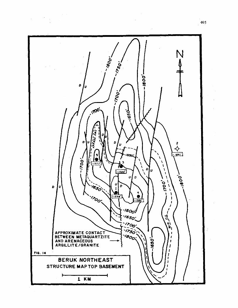
The ”Top Basement” structure map (Figure 14) shows that the Beruk Northeast structure is broken into a series of north-south oriented fault blocks. Most of the faults do not extend into the overlying Telisa section (Figure 12). Beruk Northeast wells No. 3 and No. 4 were drilled into separate fault blocks. A common oil-water interface is absent in wells No. 3 and No. 4, thereby suggesting that either the fault separating these two wells is a sealing fault or the reservoir is discontinuous between the wells. The oil-water contacts are unknown in wells No. 1 and No. 5 since neither well penetrated the oil-water interface.
The oil produced from the Beruk Northeast basement reservoirs has a average gravity of 38.3 degrees API and a pourpoint of 115-120 degrees Fahrenheit, which is similar to the gravity and pourpoint of most other Coastal Plains oil fields. The Beruk Northeast oils are probably derived from the same rich Tertiary shales source rocks as the other Coastal Plains oil fields. Oil presumably migrated away from the source area through Sihapas sands or along the Pre-Tertiary unconformity surface into the Beruk Northeast basement high. Faults may also act as conduits for oil migration in this area.
FIELD PRODUCTION Beruk Northeast No. 1 was placed on production in

389
early 1981. Initial production averaged about 2200 BOPD (0.2% water cut). Figure 15 summarizes the production performance of this well. Decreasing oil production together with increasing water production has resulted in a relatively constant produced fluid gross, indicating that the fault block drained by this well has a very active water drive. Formation pressures declined only 30 psi after one year of production. To date Beruk Northeast No. 1 has produced in excess of 1,100,OOO barrels oil, 640,000 barrels water and 42 MMCF associated gas. AU production from this well is evidently obtained through the naturally-occurring fracture system in the Pre-Tertiary metaquartzites since negligible matrix porosity exists in the core.
Beruk Northeast No. 3 and No. 4 went on stream in 1983 at initial production rates of about 200 BOPD and 25 BWPD. The relatively low production rates (compared to well No. 1) are due to the pow reservoir characteristics of the weathered argillite and granite reservoirs.
Beruk Northeast No. 5 began production in 1983 at an inital rate of 300 BOPD and 40 BWD, however within 3 months this well was producing 100% formation water. Although this well is located within 900 meters of Beruk Northeast No. 1 and produces from a reservoir litholo- gically identical to the BeruqNortheast No. 1 reservoir, the production performance has been totally different between these two wells. Beruk Northeast No. 5 has pro- bably penetrated a fault block with an oil-water contact structurally higher than that in the Beruk Northeat No. 1 fault block. The discontinuity of the oil-water contact between these wells is probably due to the discontinuous nature of the fracture network. Alternatively, the presence o f an unrecognized water-bearing fracture system in Beruk Northeast No. 5 may have caused a sudden water influx into this well.
CONCLUSIONS This paper describes the hydrocarbon potential in
Pre-Tertiary basement rocks in Indonesia and reviews the Beruk Northeast field as a case histby of basement production in the Central Sumatra Basin. The geology of this field is complex, and the production performance of the Beruk Northeast wells has been less predictable than wells in fields producing from the normal Sihapas Grixp Sandstone reservoirs.
The importance of coring fractured and weathered base- ment reservoirs can not be overemphasized eventhough core recovery can be poor and mud losses are common when drilling fractured basement. Nevertheless our experience in this oilfield indicates that cores must be obtained because they provide the only direct method of observing the fracture network and obtaining fbndamental reservoir data.
Cummulative oil production to date from Beruk North. east is approximately 1.23 million barrels of oil. Although
this field is relatively small, the existence of nearby pro- duction facilities as the Beruk-Zammd pipeline encourages exploration and development of fields of this size. Beruk Northeast indicates that Pre-Tertiary basement can not be disregarded as an exploration objective in Southeast Asia. Beruk Northeast also serves as a reminder that whenever feasible, all exploratory wells in Southeast Asia should be drilled into basement.
ACKNOWLEDGEMENTS The authors wish to thank the management of P.T.
Caltex Pacific Indonesia, Chevron, Texaco and Pertamina for their permission to publish this paper. We also extend our thanks to Roger Eubank for his advice and suggestions during the preparation and writing of the paper. The fine effort and cooperation by the CPI Exploration Division’s drafting and secretarial staff are most appreciated. We also express our thanks to Chevron Oil Field Research Company and Lemigas Biostratigraphic Services - Robertson Research for the petrographic descriptions and radiometric age dates discussed herein.
REFERENCES CITED
ADIWIDJAJA, P., and de COSTER, G.L, 1973, Pre-Ter- tiary Pakotopography and Related Sedimentation in South Sumatra: Proceed. 2nd Ann. Conv. Indon. Petrol. Assn., 4--5/6/1973, Jakarta, pp. 89-103.
CAMERON, N.R., CLARKE, M.C.G., ALBISS, D.T., ASPDEN, JA, and DJUNUDDIN, A., 1980, The Geo- logical Evolution of Northern Sumatra: Proceed. 9th Ann. Conv. Indon. Petrol. Assn., 27-28/5/1980, Jakar- ta, pp 149-187,
CHUNGHSIANG P’AN, 1982, Petroleum in Basement Rocks: h e r . Assn. Petrol. Geol. Bull., v. 66, no. 10, pp.
EUBANK, R.T., and MAKKI, A.C., Structural Geology of the Central Sumatra Back-Arc Basin: Proceed. 10th Ann. Conv. Indon. Petrol. Am. 26-27/5/1981 , Jakarta, pp. 153-196.
FONTAINE, H., and MAMGUY, M., 1982, Don’t Forget Asia’s Older Rocks: Petroleum News Magazine, vol. 12, no. l l ,pp .8&10.
covery and Development of Minas Field: Asean Council on Petroleum (ASCOPE) Confr. 11-13/10/1977, Ja- karta.
. LANDES, K.L., AMORUSO, J J., CHARLESWORTH, L J ., HEANY, F., AND LESPERANCE, P.J., 1960, Petroleum Resources in Basement Rocks: h e r . A m . Petrol. Geol. BuU., v. 44, no. 10, pp. 1682-1691.
1597- 1643.
HASAN, M., KAMAL, and LANGITAN, F.B., 1977, Dis-

390
LEE, Rk, 1982, Petroleum Geology of the Malacca Strait Contract Area (Central Sumatra Basin): Proceed.llth Ann. Conv. Indon. Petrol. Assn., 8-9/6/1982, Jakarta, pp. 243-263.
LI GUOYU, 1981, "Buried Hill" Structure in the Bohai: Petroleum News Magazine, vol. 12, no. 9, p. 17.
MARTIN, R., 1952, The Development and Oil-Bearing of the Lower T e h Formation in South Sumatra: un- published report, N.I.A.M., 7/29/1952, Pladju. South Sumatra.
mRTOSON0, S., 1975, Geology of Pungut and Tandun Oil Fields - Central Sumatra Basin: Proceed. 5th Ann. Conv. Indon. Petrol. Am., 2-31611975, Jakarta, pp. 165-179.
MERTOSONO, S., and NAYOAN, G.A.S., 1974, The Ter- tiary Basinal Area of Central Sumatra: Proceed. 3rd Ann. Conv. Indon. Petrol. Assn., 3-41611974, Jakarta,
OIL. + GAS JOURNAL, 1982, Esso's Chonnabot Find Draws Interest to Sparsely Drilled Thailand Basin, vol. 80, no. 48, pp. 90-94.
pp. 63-76.
ROEZIN, S., 1974, The Discovery and Development of Petapahan Oil Field, Central Sumatra: Proceed. 3rd Ann. Conv. Indon. Petrol. Assn., 3-41611974, Jakarta, pp.
TIWAR, S., and TARUNO, J., 1979, The Tanjung (South Kalimantan) and Sei Teras Fields (South Sumatra): A Case History of Petroleum in Pre-Tertiary Basement: Proceedings of the Committee For Coordination of Joint Prospecting For Mineral Reserouces in Asian Offshore Areas (CCOP) Sixteenth Session, 10-189/1979, Ban- dung, Indonesia, pp 238-247.
YAN DUNSHI and ZHAI GUANGMING, 1980, Explora- tion Practice in and Prospects of the Buried Hill Oil Fields in North China: Principal lecture presented to the United Nations International Meeting on Petroleum Geo- logy, Beijing, China, March 1980, published in Petrole- u'm Geology in China, ed., J.F. MASON, Penwell Books, Tulsa, Ok., pp. 92-100.
ZILLMAN, N.J., and PATEN, RJ., 1975, Exploration and Petroleum Prospects, Bula Basin, Seram, Indonesia: Proceed. 4th Ann. Conv. Indon. Petrol. Assn., 2-3/61 1975, Jakarta, pp. 129-148.
1 1 1-127.

'VlS
V IS
V3H
lnOS
'NO
lWL13 V
ON
nS 3
Hl A0
NIOLlVYJ lS
3MH
lCK
)S 3
HlO
N0
1V
SN
ISW
3HV
-N3W
I'SlJ
FIG. 2
LO
CATI
ONS OF
INDO
NESI
AN O
IL FIE
LDS
PROD
UCIN
G FR
OM P
RE-T
ERTI
ARY
BASE
MEN
T RO
CKS
w
W
h)

393
RUP~T ISLAND
\ N U M ~
| ",~. \ '
~/ COASTAL PLA|IiS "|LJ~¢K
a>~4"" o,.+.e+ee.,
\ DUll
"\
I \ , -
% %
I
I I
I t I
I I I I k
\ \
,-~..~+o.\ I \
, \
I i
I I
t I
I PEDI i
\
\
BENGKALIS ISLAND
PAOANG ISUUIO
• - , ' \ ~ , ,
/ .. j .
/ I I L M I - /
I
COASTAL .PLAINS BLOCK
I - - -
RUMOAI
~ i ~' PEK&NOARU
I I I IPA! l l l l l l , / "
\
\
ZAMRUD
II ZAMRUD SOUTH
0 I
KMS 25 " 1
\
FIG.3 +COASTAL PLAINS BLOCK- LOCATION MAP Bill . . II J . . . . , [ I

394
PADANC ISLAND
COASTAL PLAIWS BLOCK
0 KYS 25 m FIG.4 MAJOR TECTONIC ELEMENTS
(MODIFIED FROM EUBANK+MAKKl,1981 AND LEE.1982 1 I

395
F16.5 STRATIGRAPHIC CHART OF CENTRAL SUMATRA BASIN
AGE EPOCH
PLEISTO-
RECENT
I SERRdlVAk
LI AN
I "
I v
=E UAN
AQUl =
PALEO- GENE
TERTlM
sw U NITS NE
MHAS FY.AULNtll)rr
G PETANI FM.
PEMATANG FM. i-- BASEMENT
LIT ti OLO G Y
Gmret,wnd and cby
Grtenish 9my thpk, sandstone and siltstone
Brownish groy,calcoreous shale ond.silistont , o c ca s iona I It mes to ne s
Fine to medium grained sandsfones and shale interbeds
Medium to coarse mined sand stone and minor s PI ole Groy,cokoreous shale with sow Stone interbeds and minor limestone
Fine to coarse grained sund- stone, con glomera tic
Red and green variegated cla stone and carbonaceous
grained sandstone
Greyw oc ke , qua r t II te ,gron I te orqifli?e
sha 1 e p d fine to medium
AFTER: WHlTE(I975) AND W O N G S O S A N T l K O ( 1 9 7 6 ~ , TIME SCALE FROM VAIL/ MITCHUM (19791, EUBANK A N D M A K K t { 1981

396
L

TABL
E 1.
COAS
TAL
PLAI
NS B
LOCK
W
ELL
DATA
Su
mna
ry o
f Ba
sem
ent
Cor
e D
ata
wit
h Aa
e D
ates
Wel
l Na
me
Base
men
t Li
thol
ogy
Age
Oat
es
Beru
k No.2
Beru
k N
orth
east
No.
1
Beru
k N
orth
east
No.
2
Beru
k N
orth
east
N0.
3
Beru
k N
orth
east
No.
4
Beru
k N
orth
east
No.
5
Bung
su N
o.1
Gun
tunq
No.1
Pak
ntna
No.
Pusa
ka N
o 1
Idrl
s No
.
Pyr
itif
ero
us
sil
ty S
HALE
, ex
trem
ely
fin
e t
o f
ine
gr
aine
d,
very
low
gra
de m
ctam
orph
lc a
rgill
aceo
us
rock
wit
h a
wel
l de
velo
ped
clea
vage
.
Bre
ccia
ted
META
QUAR
TZIT
E,
alm
ost
en
tire
ly c
ocrp
osed
o
f an
hedr
al a
uart
r;
smal
l am
ount
of
nlca
ceou
s m
ater
jal
alon
g sh
ears
was
use
d fo
r K
-Ar
age
datln
g.
Mus
covi
te-t
ou
rnli
ne
GRA
NITE
.
Aren
aceo
us A
RGIL
LITE
.
Gar
net-m
usco
v 1 t
e-to
urm
a 1 i ne
MIC
ROGR
ANI T
E.
Mus
covi
te r
ich
hor
nfel
sic
ARG
ILLI
TE.
Bre
cc ia
ted
MET
AOUA
RTZ I
TE.
Cat
acla
stlc
mus
covi
te G
RANI
TE,
orl
gin
all
y a
md
lu
to c
oars
e ar
aine
d ac
idic
iqn
eous
alu
tonf
c w
k
whi
ch h
as u
nder
gone
sev
ere
defo
rmat
ion.
Cat
acla
stic
mus
covi
te G
RANI
TE,
ori
qin
all
y a
coar
se
qral
ned
acid
ic i
gneo
us o
luto
nic
rock
whi
ch h
rs
unde
rgon
e se
vere
def
omat
lon.
Cat
acl a
sti c
tou
nna
11 ne
-bea
ri ng
usc
ovl
te W
ITL
w
hich
has
bee
n af
fect
ed b
y co
nsld
errb
le
def o
mt
Ion.
Dar
k gr
ey s
ilty
frac
ture
d SH
ALE,
sl
atey
an0
h
lgh
ly i
ndur
ated
, fl
ne
ly c
ryst
al1
In
calc
ite
in
fr
actu
res.
Hyd
roth
emal
ly o
r d
iaq
e~
tic
all
y alt
dn
d
pera
lum
inou
s GR
ANIT
E co
nsls
~lm
g of ouartz,
mic
rocl
ine,
al
tere
d ol
aqio
clrs
e.
usc
ovl
te
Dyr
ite
and
apa
tite
.
54.5
2 0
.6
M.Y.
(Ear
ly E
ocen
e),
by K
/Ar.
276
10 M
.Y.
(Ear
1.r
Perm
ian)
, by K
/Ar.
179 f 5
M.Y.
(E
arly
Jur
assf
c),
by K
/Ar.
116 f. 5
M.Y.
(Ear
ly C
reta
ceou
s),
by K
/Ar.
203 f 4
M.Y
. (L
ate
Trl
assl
c),
by K
/Ar.
123
2 6
R.Y.
(Ear
ly C
reta
ceou
s),
by K/Ar.
Rad
iom
etric
ape
dat
ing
not
wss
ible
.
150
+ 2
R.Y.
(Rid
dle
Jura
ssic
),
by K
/Ar.
-
122
2 2
M.Y
. (E
arly
Cre
tace
ous)
, by
K/A
r.
110 t
2 M.Y
. (E
arly
Cre
tace
ous)
, by
K/A
r. -
Dev
onla
n/C
arbo
nife
rous
bou
ndar
y ag
e da
te f
rom
gs 1
po
l ow
.
208
+ 7
M.Y.
(Lat
e T
rias
sic)
, by
K/A
r-m
usco
vite
. 20
6 T
8 R.
Y. (L
ate
Tri
assi
c),
by K
/Ar-
slbl
tt.
101
7 4
R.Y
. (L
ate
Cre
tace
ous)
, by
K/A
r-m
icro
clin
e,
295
z 3 H
,Y.
(Lat
e C
arbo
nlfc
rous
),
by Rb/
Sr
w
W
-3

\
a /An
0
AGE
t4.Y.-
PRE-
TERT
IARY
GR
ANIT
E
TUFF
0 Q
UART
ZITE
&
DEEP
WAT
ER ROC
KS I
\ 0
10 50
10
0 --
- 1
KILO
MET
ERS
RADI
OMET
RIC
AGE
DATE
S.

46E

400
3 !i!
a
a
Lt t- a W I t- 0 Z Y 3 oc W
w I t-
W > 0 W 1
a n
m
a
8
!i a cn iij
0,
U 3
LL
iii
9

EA
ST
BER
UK
NO
RTH
EAST
FIE
LD
STR
ATI
GR
APH
IC C
ROSS
SEC
TIO
N FI
G. 1
0 1

402

403
404
FIG. 13 COMPOSITE LOG BERUK NE. No.4
14 - S

406
l0,QOO
I ooc
2 n \ u) J W K
4 a m
I FIG.6 BERUK NORTHEAST N0.I I PRODUCTW PERFORMANCE
I I I I I I ' I I I I I I I I
I ' 11 I I 1 I 1 1 1
I I 1 I 1981 1982 1983 I984 1985