the geomorphology of chungking and its neighbourhood
TRANSCRIPT
BULLETIN OF THE GEoLOGICAL SOCIETY OF CHINAVOL. XXII, NOS. 1-2, PP. 133-187, 1 FIG., JUNE, 1942
The Geomorphology of Chu ngking and its Neighbourhood*
By
Su TING
(Wational Central Un iuer!ity)
With t Text-Figure
CONTENTS
introduction PageI. Geological Background .....................................................133
The Draitge Pattern .......................................................13
The Cretaceour PlainGeneral Feattires ..........................................................140
H. The Gravel Terraces.........................................................141HI. Origin and Date Gf the Cretaceaus Plain .................................. 144
Deposits in the Incised Valley of the Chialing River ......................... 146The Synclinal Mesa and Hills ............................................. 14
Summary .................................................................The Anticline
I. The Hog-backs of Jurassic R.cks ...........................................Is,II. The Axial ¡liii Ridge ......................................................152
HI. The Karst .................................................................1531efertnces
INIPODUCT1ON
I. Geological Background.
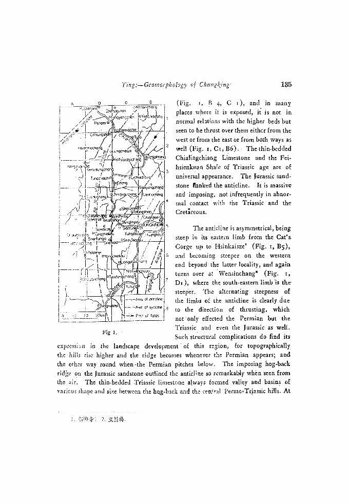
The region under discussion is to the north, west and scuth of ChungkiLng.It is a region involving three dominant anticlinal ridges and a few minor structuralundulations. The Koloshan' anticline situates in the middle of this region (Fig.
Received for publication in March, 1941. 1.
.134 Bulletin of the Geological Society of China
r, B5), the Huangkoya2 aniclinc to the south-east (Fig, r, D5), a1 tite-
Hsishanping' anticline to the north-west (Fig. r, Br).. Between the Hsishanpingand the Koloshau anticIiies situates the rather narrow and simple Pehpei4 synclinewhich stands in rather sharp contrasts with the undulating Chungkiug syncliucbetween the Koloshan and the Huangkoya anticlines.
All these antic-lines converge t the north-east at Huayinshan, out off the-map, hence they are sepàrate ranges from a common vertex. It seems fairlyapparent that the minor upfolds within the Chugking syncline are but slighundulations and that these upfolds were introduced siniultaneousy due to shearduring the rising of the anticlines. Nevertheless, the writer does not wish to lay'any emphasis o the purely structural aspect of the question, but wishes to give-a short account of the structural facts; which are related to the present discussion.
The Koloshan anticline, provisionally termed, is situated to the west ofChungking. various sections of this anticline ha,-e been described by Ara. heim,who apparently had not been aware of the fact that these sections he describedbelong to one and cOntinuous anticlinal ridge. This anticline strikes approimatel
north and suth for about 550 li northward from the Cat's Gorge, where theYangtze cuts across, and -there turns gradually towards the north-east, crossedby th.-Chialing river, tributary t the Yangtze at Kuanyin Gorge' (Fig.
x, C'e-) and continued in that direction till it meets the other coüvergiaganticlines.
Flanked by the hard, massive Jurassic sandstone, the anticline has--
Triassic asid Permia'ii limestones and shales as its core and appears to havepierced through the Cretaceous cover, which undoubtedly has been involved inthe folding. Along the axis, the Permian cherty limestone frequently pitches.
1. I1I. The Koloshan antidine, the Htangkoya anticline and the Hsishanping anticline--
of the present writer have been resuectiveZy esinated as Kuanyinhsia anticline, TungIoksianticline and Wentaughsia ntic1ine by the Geobgical Sorvey of Szechoan (See C. Y, Let &others: Coal fields beteen 1oer Chialirguhiang and T'c.c.iang, Menloirs. of Mineral Resources-
of the Geological Sur'ey Of Sao, N-. I, 193f, in Chinese).ibe Editor2. :ikt 4lI19; 4..t;3. UI: 6
f3 C. D
o oWènsrncranqhi1zesI1cn ./
eoaogPeope //
orThOODZe
roac
3
serrOchOp,
ç.3 (
¡ ' )r'q \ //- h.q(r;- ,.
ç"U / j ! .shofl /
snng ' -The anticiine is asymmetrical, being..cr/u'go ¡ steep tn its eastern limb from the Cat
T-1SC
Gorge up to Hsinkaisze' (Fig. r, B5),/4 6 and becoming steeper on the western
/ / end beyond the latter locality, and again
r turns oser a Wensmchang2 (Fig r,JDr), where the south-eastern limb is the
steeper. The alternating steepness ofxs on'cIo the limbs of the anticline is clearly due
As of ocí*to the direction of thrusting, which- - o' foies - Inot only effected tne Permian but theTriassic and even the Jurassic as welt.Such structuraI complications do find its
expression in the landscape development of this region, for topographicallythe hiPs rise higher and the ridge becomes whenever the Permiari appears; andthe other way round when -the Permian pitches below. The imposing hog-backrjdc on the Jurassic sandstone outlined the anticline so remarkalAy when seen fromthe air. The thin-bedded Triassic limestone always formed valley and basins ovarious shape and size between the ho.g-back and the central PermTrassic hills. At
lo
Fig 1.
L. :J1'/ : 2,
Ting:.-Gco1s/orp/ ology of Chungfing - 135
2
(Fig. i, B 4, C i), and in manyplaces where it is exposed, i is not innormal relations with the higher beds butseen to be thrust over them either from thesvest or from the east or from böth ways aswell (Fig. r,Cc,B6).- Theehin-beddedChialingchiang Limestone and the Fei-hsienkuan Shale of Triassic age are ofuniversal appearance. The Jurassic -sand-
stone flanked the anticline. - It is massiveand imposing, not infrequently in abnor-mal contact with the Triassic and theCretceous.
1S6 Bulletin oJ t/2C Geological Society of China
Kaotientze' (Fig. t, B5) where the Permian pitches below, the Triassic limestonevalley has its greatest width of about i6 kilometers. But apart from the aboveparticulars, the landscape is in general of regular character, consisting of anaxial ridge of Permia and Triassic shale, a Triassic limestose valley c basinon both sides, flanked by a sandstone and shale series of Jurarsic age. Each ofthe above topographical divisions will be dealt with separately below.
The Huangkoya and the Hsishanping anticlines will not be dealt with inthe present paper. It would be sufficient just to mention that Triassic limestonesexposed in the former, while only Jurassic beds were arched up into flat-top ridgein the latter.
The Chungking and Pehpci synclines are all of Cretaceous rocks. They
are as a whole lower than the onticlines, but have been much dissected thatthe topographical elevation is less than the structural one and mesa hills havebeen formed along the synclinal axes.
Throughut the present paper terzs such as "the Çrctaceous plain" the"rurassic hog-back" and the like are used. They are only convenient designa-tions meaning "a plain formed on Cretaceous rocks," 2nd " a hog-back ridgeformed on Jurassic rocks" respectively.
II. The Drainage Pattern
Viewing the region as a whole, it is advisable to begin with a study ofthe drainage patterns -exhibited, and to seek therefrom the degree of adjustmentof geomorphologie processes to the tsnderlyng structures.
A. On the Anticline
On both flanks of the Koloshan anticline, there are well-developed
transverse consetpents, taking either the Chialing or the Yangtze as their Localbase-level. Some of these consequenis had their headwaters from the Jurassichog-back, cutting deep ravines in the sandstone, with steep gradient and a veryyouthful thalweg. Others headed from the axial hill ridge, running, in mostcases, straight a&oss the Triassic limestone basin, piercing through the Jurassicand dropping steeply down the aeticline, forming also deep canyons and ravines.
1. .
Tiog: -'-Geomorphology of Chuagking 137
The hog-back ridge, instead of being continuous, is thus cut up into manysections, and between them, the gentle valley floor of the limestone baths "hangs"over the Cretaceous plain below.
The Triassic limestone valley exhibits an intermittent centripetal draitiage,which attains its characteristic developments only in e-ertain places. Deviatingfrom the most typical form are the shallow basins, varied in shape and sizesupporting irregular centripetal drainages either of inland character or withoutflows through the transverse consequents. It is clear that some of the transverseconsequents, which were initiated on the hog-back were able to cut through itand 'captured' the basin drainages which developed on the limestone.
The tributaries forming the centripetal drainages are mainly of subsequentorigin. Small riveis consequent to the slope of the axial hill ridge are foundto be subsequents, following cross-faults which are common in this region.There are cases wheie such a fault-line control can not be demonstrated andthese should therefore be considered as consequents. Similarly, obsequents aisedeveloped, but in a lesser degree and where the transverse cønsequents havesucceeded in cutting through the hog-back, obsequents, if present, would beiuverted. Furthermore, it is most likely that the obequents were also developedalong cross-faults and may as well be termed ob-subsequents.
Subsequent of the classical type calling for a weak rock control arecommonly met with. On- the axial hill ridge, they follow reguiarl.y the weakshaly bed between the Chialingchiang Limestone and the Feihsienkuan Shale withsuch a regularity that geomorphology successfully helped to bring out thestratigraphy. The transverse consequents send out small subsequents, eródingheadwards along the same layers from opposite sides, and have reduced the consequentdivide in that particular locality to a series of saddks in align*aent with eadother. There are rivers flowing a short distance along the strike of bed in thelimestone basin. They are most probably subsequent along bedding planes, orloints, though thcir structural control can hardly be demonstrated, for the limestonevalley or bosin of the shallow ype has everywhere been cultivated that renderedclose observation dioult.
The soft shales and sandsone of the Jurassic coal series intervening betweenthe two hog-backs formed by the hard and massive sandst.ne beds, alio give rise tosubsequent valleys as well, some of which have developed to a greater extent
138 8ullctin of the Geo'ogic! Society of China
than others which still linger in the "saddle stage'' similar to those seen on theaxial hill ridge. In general, there are only two distinct hog-back ridges, besidesthese there are a number of çinor ones. Tir ote localty, five hog-backs on theJurassic have been etched out by the process.
From what is presented above, it is evident that on the anticline, trellispattern is well developed and it has attained a stage of development approachingthe maximum of Glock's stage of elaboration, beyond which adjustments andcapture would have taken place. Apart from the trellis pattern which is to beexpected in such a region, the limestone add a cetripetal one, which is at variousstages of its development grading from a typical one to an ordinary trellis-lookingpattern.
A sall part of integration has been attained on both flanks of the anticlinefor the consequents have been able to capture the centripetal drainage. It isalso on this part of the anticline that subsequents have developed to a greaterextent.
B. On the Cretaceous Plain
Trellis patter-n reached its excellent develepment on the Cretaceous piainThe transverse consequents leaving the anticline tends to be deflected by structuralcontrols, either following courses developed on weak shale beds of Cretaccousage, or sinulating meander bends formed along joints.
Within the Pehpei syncline, the general direction of the main river foliowclosely the strike of rocks. Ir heads at a mile south of PeishihyP (Fig. i,.AB6), flowing northward on a flat alluvial plain up to beyond Tuchuchang
Fig.. r, Ak), where the alluvium becomes thinner, the syncline beeomes
shayper, and therefore rocks crop out at the surface. The river then winds andbends through courses of subsequent, consequent, and obsequent origin in
various sections and drains into the Chaling. The river can hardly be termeda longitudinal consequent, for along its whole course it is sItuated on the easterliside of the syncline axis, and is determined by structure.
1. rnJf; 2. ±.3. The profile of an anticline and a syncline may be taken as two curvee having a pOifl
uf deiection in between. If we defined the longitudinal consequent as a river consequent tucrigin in the syncline, then the river will be subsequent a it cuts below the original cover.eacept whee it follos closely the synclinal Hsu s, it may just as SFCII oc called .
subsequent.
Ting :Gcomorphology of Ciiungiag 13
Within the Chungking syncline, minor doming up of th Cretaceous
complicated the issue. A small dome trending north-east south-west can betraced from Jenhochang' (Fig. i, D4) to Yangkungchiao where it pitchei.The Pan creek3 (Fig. s, D4, C4-5) flows along the direction of the pitch,found itself firmly upheld by the hard massive sandstone layer, failed to rejuvenateits bed to any great extent and therefore it hangs over the Chialing, whichbetween Tzechikou4 (Fig. r, B5) and Siaolungkan9 (F'ig. r, C, hassucceeded in cutting right across the structure. ')u the south-eastern and
eastern side of this minor fold, the structural synclinc gives rise to an irregularmesa.like mass, highest in its elevation in the Cretaccous plain. Its north-westernescarpment near Siaolungkan is a prominent feature and can be seen at a distance.On the north-western side of the dome, the Chialing river made a series ofbends, following generally the trend of a syncline, which can b traced from
Yuehlaichang (Fig. r, D2-3) through. Lichiachairg1 (Fig. r, C3), to Chinkou-chang° (Fig. r, Bi), beyond which the syncline seems to be too sharp for anormal relatiOn. Owing to the existence of a mesa-like mass on its north-easternside, the radial drainage expected on a dorne only developed on its north-western.side, yet here and there a minor trellis imprint occurred indicating clearly the
advanced stage the dome has been dissected.
The river flowing from Sinchiao (Fig. z, B5) to Tszchikou, follows anortherly course and joins the Chialing ja an obtuse .ngle, contrary to the
normal habit o tributaries. It is a subsequent river; A short distance north ofSinchiao, the river is seen meandering between two cuesta ridges (Fig. r, B C5).Further down, the river crosses the pitch of the fold mentioned aböve, at
Yangkungchiao. Beyond this locality, the river seemed to have pursued a.coursedetermined by the abnormal contact of the dome and the Koloshan anticline:This is evident, for on both sides of the river, the dip of the Cretaceous
bed is in opposite direction and it is rather too sharp to be.a continuus syncline.
Southward from Siachiao, the Cretaceous plain is mainly under trellisdrainage pattern comparable to that in the Pehpei syncline. The divides arenarrow and low. Dendritic drainage pattern is seen over the synclinal mesawhere the beds attain a slight dip towards the Yngtzc.
j. jj; 2. 3. 4. fl; 5. ,jsij; 6. t; 7. ?i;. IUF}&; 9.
140 Bllct,n oJ tue Gcologicil Society oj Ciia
It is clear from be abave consideration of the drainage pattern that theevolution of drainage in this area has everywhere attained a maximum stage ofelaboration, being youthful in aspect, yet perfectly adjusted to structures, a factanticipating poly-cyclic development.
TIi CRETACI3OUS PLAIN
I. Generol Features
Having dealt with the general drainage pattern of the region as a whole,attention may be drawn to the study of the geomorphic evolution of theCretaceous plain. This plain comprising seven or eight cuesta ridges in thePehpei syncline, reducing to only three or four in number in the Chungkingsyncline, due to minor upfolds, is a plain of erosion,, which has succeeded indifferentiating the weak from the sng both geologically and structurally. In theneighbourhood of Pehpei, the ridges are more or less continuous, regular and ofsimilar elevation. Southwards beyond Hsinlungchang' (Pig. i, B3), the synclinebecomes gentler and therefore much broader in width and is deeply buried byalluvium. Since the alluvium is sometimes as thick as ten mcters it is unlikelythat the present streams can be responsible for its deposition, for they are rathertoo small to be compared with the wide, flat valley in which they now flow. Theplain rises in elevation southwards reaching an elevation some 50 in. higher thanPehpei at Peishihyí. The gradual increase of the elevation, of the width, andof the flatness in topography, is easy to understand, fori that upstreamdirection the syncline is structurally more open and less eroded after the alluriujhas been deposited upon the erosional surface of the Craceous rocks. Whether
w not, there has àncc been a much larger river flowing across this alluvialplain, and to this river the a4luviuin is responsible ftir is not yet ascertained.
A mile south of Peishihyi, the alluvial plain is deeply incised by the narrowcanyon of the Elbow river' (Fig. r, .A6). The river originally flows iorthwards,now takes a sharp bend towards the east, cuts through the fifth cuesta ridge(counting the Jurassic hog-back as the first), pours. down a o-m. waterfall, thenturns southwards an.l iflciSesa canyon 200 m. in length, continues to run in thatdirection, and drains into the Yangtze. The lower course of .this river is nowflowing side by side with its head, hut in an opposite direction, separated by
i.: 2.
1. : 2
T.:Geomorizo1ogy of Churigki;g 141
a zoo-m. wide cuesta ridge with a difference of elevation approximately 50 m. atShihpanchang'. It is evident that owing to the incision of the Elbow river, theoriginal alluvium cover has been removed and the land surface composing of scarpsand vales re-exposed, which is comparable both in form and elevation to that inthe Pehpei reg.ion.
The Elbow river is clearly the captor and the waterfall is due to the originaldifference in elevation of the beds of the captor and the captive. The dividebetween the diverted and the beheaded river is only xo m above the former's presentbed, indicating a very recent date of the piracy in this region concerned.
In the Chungking syncline. cuesta ridges are aU weil exposed, the eleva-tion of the cuestas is about the same as those in Pch.pei, sorne 50 m. below thePeishihyi alluvial plain. The. minor arch, cut across by the Chialing river, is of
similar elevation, thus, it is clear that in spite of the structural unduations.,erosion has gone on so far as to give accordant topographical heijhts.
11. TIje Grasiel Terraces
The apparent evenness of the crestlines of the cuestas has led Heim, in1931, to the belief that it is the product ef an advanced stage of erosion deserv-ing the name ."peneplane" (i-Íçim, p. 32). Hesitating to accept Heim's determination, the writer let it be designated as an erosional surface with regards of whichwe now have ample evidence. On botE sides of the Chialing river gravel deposits
have been found. At Sunglinpo' (Fig. t, C5), the gravel occurs on the south-eastern limb of the dorne into which the Chialing has maintained a course acrossthe structural grain some too m. below, at an altitude too nr, above the river atlow waber stage. The gravels, well water-worn, rarely sub-angular, varies in sizef rom a cobblestone (x-i V2 ft.) to a pebble ( cm..) and is composed f mostly,
quartzite seems to have their source in the Devonian formation beyond the limi&of the Red basin. The gravels, having. a fine clayey matrix, i not well stratified?nd has suffered great erosion so that the presunably original terraced form hasbeen partially destroyed. . The existence of an erosional surface, roo m. abovethe present Chialing can be deduced from this picce of evidence alone.
;j4 Bulletin o] the Geological Society of China
More support cornes from the region cast of Tzcchikou. At the Gravel
hilP (Fig. y, C4), gravels of similar character to the Sunglinpo gravel is seen
to form a eat-top terrace resting on the truncated top of a cuesta ridge, clearly
being eroded befote the gravel deposition. The terrace, according to the map2 is3697 m. above sea level or about 200 in. above the Chialing river, hence roorn. above the Sunglinpo gravcl. Readings from Paulin aneroid gives 38J rn. Thethickness being estimated to be about 30 n, though not everywhere the same, forneighbouring flattopped cuesta ridges show no trace of gravel but the under-lying reddish clay at such altitude, 20-30 m. fower than the ravel hill. The
same formation is found both to the, north and south of the type locality, havinga total north and south distribution of about 3 km. and an east and west widthat its broadest only 9/ro of a kilometrr.
Two km south-east of the Gravel hill, graels occurred at the top of Talung-shan' (Fig. ï, C4), which appeared as a distinct mesa rising above the generalplain level from Sunglinpo. lt is 35 tnt below that of the Gravel hill. Theformation, has apparently been much eroded to such an extent that only the basalpart of about one or two meters remained, hence, the lower in elevation of thislocality does not speak' against it being the saine formation as at Gravel bill.
One km. east of Talungshan, gravels overlying a layer of vivid red clay
is seen at the Red Earth hill4. The gravels vary from about 3/8. of an inchtó a foot in diameter, sub-angular to well-wórn, óften with marks resemblingstriation. Quartzite is the dominant Constituent and quartz, also numerous whiledak slate and limestone pebbles are rare. The underlying clay is extremely fine.The formation is about two nters thick, overlying ah eroded plane surface onthe Cretaceos, hence, the underlying clay can not be residual. The gravels anthe clay formed a terrace some ro-rs ¡ji. highabove the in-grown incised meanderof the Pan creek and' is 50-60 m. lower in elevation 'than that occurred inTalungshan. (Heights read from a map indicates a digerenee of 63 rn.. from
H.
There are two editions of the 1:25,000 map of the region. The earlier edition publishedin 1934 is, in general, very rough an'l can not be depended upon. The later edition, pnblished lastyear (1940), is much better, though not accurate to details. The latter i' the one have referredtt. it is published by the Chief Office of Land Surveying.
flj.4 -tI
Tin :Gro;ncï5!hoioy cl Chu/zing 143
levelling 68.9 ni. while from Pauiin reading only 57 m.). This gravel terrace isroo ni. above the Chialing river at Sunglinpo, hcnce, it can be correlted withthe Sunglinpo gravel as the lower terrace.
The distance between Sungliripo ajid both the Gravel hill and Talungshinis in 5traight line of about 4 km., and the fall in the elevation of the gravelterrces between them is I iv 40, w1ich is rather too steep to be regarded as aonce continuous sheet. The separation cl them into two distinct terraces is hereconsidered much more reasonable.
Careful observation reveals the fact that apart from the lower terrace, inwhich the Pan creek has incised 10-15 m., there are a widespread occurrenceof similar gravels on both banks of the river at levels slightly lower, being onlySo or 90 m: above the Chialing. These occurrences greatly obscured by the in-tense cultivation, nevertheless show clearly that the river was formerly flowing ata much gentler grade, being i in 300 instead of r in 8o which it now maintains.
Attention may be directed to ehe Gravel hill No. 2 at Pehpei. This hillbears the same name is hpwever only 90 m. above the Chialing river. 'rhicklycovered by gravels, estimated to be 22 ni. thick, the formation is to be correlatedwith the Sunglinpo terrace, since the Chialing is itself 20 m. higher at Pehpeithan it is at Sunglinpo. Hills of lower elevation in the neighbourhood of thisGravel hill also show signs of the former presence of a gravel-cap, for they areflat-top cuestas, sparsely grael-capped and almost exactly an m. lower.
It is clear from the instances described above, that Ôver the erosion planeon the Cretaceous rocks, there are two distinct gravel terraces: namely, the high
ravcl hill terrace and the low Sunglinpo terrace, both being commonly termedthe Chungking gravels. Since the terrace gravel his a common lithological charac-ter, it is highly probable that the low terrace, being younger and widely distrib-uted, developed at the expence of th higher one. Since also the gravels werederived from rocks regn to the Red bäsin, the river that formed the high terracemust have derived its material from either a previous conglomerate bed nowextinguished, which is very unlikely, or it must have been a powerful river to bringsuch gravels some more than one foot in diameter from localities beyond the Rebasin. The suggestion that these gravels and clay my have been derived fromthe erosion of the same in tue limestone valley on the anticline can not be
144 Bulletin of the Geological SQciety of C1zia
considered profitable for only small gravels have been found at one locality onthe anticliije and the lithological character of the latter is rather locaL By farthe greater part of the deposit now remained in the limestone valley is a yellowishclay devoid of gravels.
The Peishihyi alluvial plain described above would probably be contem-poraneous with the High Terrace, both of them being higher than the rockyCetaceous plain. The alluvium is absolutely devoid of gravels. The river towhich the terrace gravels were held responsible, is then not the same as that whichdeposited the fine alluviurñ.'
III. Origin and Date of the &elaccouc Plain
Regarding this erosional surface, Barbour speaks of Tsinling stage. Barboursaid: "The striking acccdancy of height of the conical hillocks on the south-eastflank of the valley opposite Chungking suggests a still earlier pause in the degrada-tion.. . . Erosional reduction.. . leading to the development of 'peneplane' surfaceon red beds and reduction of anticlinal cores to low ridges of only moderate relief,with rd-bro%vn and vermiculated clay barns (Tsinling stage),' (Barbour, p. 37).Obviously what Barbour termed the Tsinling stage is not the same what Lee hasin mind, for the latter writer suspects its presence within the Red basin. Heimhas similar idea as that of Barbour, but being an earlier writer on this subject didnot use the stage name. Recently T. F. Hou and K. C. Young also discussed
this surface in a cautious manner and has termed it the Yangtze stage of broadvalleys. However different the exact corrlation may be, on one point they all
agree: that the accerdancy of the bill top elevations on both sides of the Chialingis a remnant of an erosional surface, which belevelkd the titled red beds ofCretaceous age. Whether it is a peneplane or only a surface of mature erosiois a matter of opinion. The Proto-Chialing has deposited gravels over this surface.The modern Chialing with its tributaries has succeeded in removing most of the'deposit and incised into this. surface to a depth of at least 8o m. This incisionbears an important clue to the dating problem. With regard to these gravels,
general belief correlates them with the Yaan stage which, according to Lee,occurred in between ¡he Yangtze gorge-cutting stage (correlates with northern
1. This river is probably conneCted with the Chingmukuan ap problçm which will be dealtwith in a later paper.
Tíog:Geomorplioiogy of Chungking 145
enho stage), as a minor phase of stability or downwarping (Lee,. p. 117).This Yaan stage is then correlated with the Sanmenian and gives it a date oflate Pliocene in age. Apparently the Fenho stage of Lee's correlation should beconsidered as actually the Huang shui stage of later terminology and therefore we-should shift the date of Yaan gravels to be lower Pleistocene accordingly.
It should be noted that in oric of Teilhad's diagrammatic section (Teilhardk Young, p. 170) of the anticline north of-Chungking, "old graveI and ver-miculated clay (? Yuhutai formation?)" is shown and in another page thesegravels were described as terraces "running at some 30 ni. over the mainriver." This description can not be matched with the above observation, for theSunglinpo gravels is at least 8o m. above the main river, some 50 m too high ifto be correlated with Teilhard's terrace. Furthermore it is not sees on Jurassicsandstone as Teilhard has shown in his section, but is deposited over the Cretaceous.No red loam is seen capping the gravel, but there is a red loam underlying it.Barbour has clearly sketched and described the same gravel layer and he correlatedit to the Yaari stage (Barbour, p. 3). Hence either the gravel bed in Teilhard'sdiagram represents something quite different which th writer has yet failéd toobserve, or it must be the same Sunglinpo gravel somehow not acctíratelv described.
in any case, if we accepted Lee's suggestion of Yangtze stage and correlates'the Sunglinpo gravels as well as the high terrace with the minor Yaan stage ofin the -Yangtze valley, we are somehow treating the ''stage" concept rather toorigid.
The gravel occurred at a.level 200-300 m. below the highest shoulder ofthe water gap on Chialing river, indicates that the Chialing has alreadyentrenched, "superposedly" perhaps, for at least aoo in. before the erosionalsurface on the Cretaceous is produced, ad if this incisibn is the first -half ofhe Yangtze stage, as it must be if we accepted Lee's correlation, -we would
imply a yery rapid stage of at least mature dissectioñ of the Cretaceous- beds
within the limits between the end of Phiocene and the. beginning of the lowerPleistocene, a period rather too short for such to have- taken place.
The second hilf of Lee's Yangtze stage is ot post-Yaan daté. This cánbe correlated if we follow J2ee closely, with the So m. incision of the Chiahingbelow the Sunglinpo gravels. All these seem exceedingly well except -when we
14G Bulletin of the Gtological Society of China
take into conideration the fact that the river Chialing being a tributary to theYangtze will have behaved accordingly only after the Yangtze has acted. If theYangtze incised its bed, the Chialing will do the same but definitely later inrime, as it will never rejuvenates to any great extent unless the wave ofrejuvenation works its way up the Yangtze and reach the mouth of the Chialingriver. Thus, if in mid-late Pliocene times, the Yangtze rejuvenates (theYangtze stage Ithe Fenho), there will be a time gap between Yangtze incisionon the Yañgtze river and the incision of the Chialing river, although theincision is due to the same cause. It is within this time gap that the Chialingcut across structure, denuded the Cretaceous rocks into a mature surface anddeposited the high and low terraces above this surface. Then the Yangtzehalted at its Yaan stage and the former wave of rejuvenation has travelledupstream an has seriously affected the Chialing, which, in response, incised itsbed below the Cretaceóus plain and the gravel terraces. This incision, forreasons to be advanced in a later page and for the reason that we need timefor the erosional surface to be developed to maturity, took place at the endof early Pleistocene (the Chingshui stage). This stage is now termed theChialing stage'
IV. Deposits in the Incised Valley of the Chialing River
Within the valley due to the Chialing entrenchment, there occurs anothergravel deposit, termed by Heim the Chiangpei conglomerate. It is well
consolidated above which lies the si't lam of the Huangkoshu2 (Fig. i, Cs)terrace, a8 m. above the river at Pehpei. The Chialing entrenchment stops
short at the deposition of the Chiangpei conglomerate which is now exposedonly at low water stages. The consolidated aspect of the formation does notnecessarily indicate ancient date and is probably a very recent depositS
Wissinana has argued for a Post-Wurm date for the Mlan Loess, andSchmitter has suggested a glacio-fluvial origin for the Chiangpei conglomeratewhich would fit nicely to Wissmann's point of view. The silt loam terrace, so
1. The term Chialing stage, was proposed by the author in his earlier manuscript. He is
happy to find that T. F. Hou bas used the sanie terminology. It however must be mentionedthat Hou's term signifies a feature quite different in date with what' is suggested by the present
author. The term Chiangpei stage is proposed for the incision qf either Panchiao or post-Chingahul
but pre.Malan date of the Chialing river.
2. t-
Ting:Geomoiphology of CYizsogi.g 141
prominently remarled by Barbour as terraces 5-35 m. above the middle Yangtze,is to the author's opinion the equivalent of Huangkoshu terrace and the Chiangpeiconglomerate of the Chialing river. The present summer flood rising to theedge of the silt loam terrace is a frequent phenomenon which shows that theterrace is only formed by a very slight and recent down-cutting of th Chialingriver since the Chialing incision. Barbour remarked also on the rocky, terracedsurface below the silt loam Similar rock platforms are often seen along theChialing (at Ertang' tFig. s, C3], at Tzechikou and at Pehpei), sometimesunderlies the Chiangpei conglomerate, sometimes the silt loam and sometimesattaining a height equivalent to that of the conglomerate.
Opinions differ on the point whether the conglomerate is older than the
silt loam tefrace or younger or contemporaneous. It is necesary to point out thefact that the conglomerate is seen only at two localities to be underlying the siltloam, while in other localities their relation is yet obscured, seemingly unrelated.is highly probable that they are formed contemporaneously. If we restore the
level of the Chialing river to a time when its flood waters did overflow the siltloam terrace, which would be pçoperly called a flood plain, then, the Chiaugpeigravel would be totally submerged even in low water stages. It is during sucha period that the surface layer of the flood water of-the river deposited the silt
loam, and the bottom layers of the river deposited the gravels. Since the gravels
were then under water irrespective of its high or low stage, consolidation tookplace during the low water stage. A slight rejuvenation of the rivershows bothdeposits as terraces. The incision is about 3 to 5 in.
The present Chialing in the region under discussion is an overfit river,
the volume has been too much for the size of its valley. This character can beacquired in two ways. A river may be overfit in certain portions, especially thelower reaches, when it re3uvenates, or it may J.e due to an oscillation from dryto-wet c nditions, either climatically or geomorphologically2. According to personal
information, the Chialing above Hochuan meanders in a wide valley with con-siderable flood plain,though slightly incised, it is in every way a ¡nature river with
a normally fitting valley. The wave of rejuvenation in th Yangtze river broughtabout during the Yangtze stage did not travelled very far up the Chialing and
I. ::.2. Causes such as glacialization. deglacialization and capturing of Irge river, etc.
Bulletin of 112e Geological Society of China
its influence is only slightly felt upstream to beyond Hochuan. This shows thatthe oLverlit character may be due to rejuvenation. But if we take into considera-tion of Schmitter's view, a glacial period of the mountains where the Chialingdraws its headwaters, will decrease the volume of the river and a deglacial periodwill increase its volume, and if-the Chiangpei conglomerate be proved to be gtaciofluvial, thern problem solves readily. Glacialization decreases gradually the volumeof Chialing during the incision and the valley tends to be narrower as the riverincises with decreasing volume. A release of v.lune brought about the Chiangpeideposition as well as the overfit charactcr.
Whatever the cause ot overhtting may be, the date of the slight incisionto level below the Chiangpei gravel must be- later than the Chingshui stage of
northern China. If relation with a glacial period is established, then the incisionmust be pre-Malan, otherwise it may he of Panchiao age.
V.. Tile Synclinal Mesa and Hills
The mass of hills standing at heights averaging about. aoo m above ihcchialing river and ¡00-150 ¡n. above the Cretceous plain represents -the axialportion of the Chungking syncline. Since it is less dissected, it retains the charac-ter of a large mesa, the escarpment of which is prominently shown on its northern
- 2nd -north-western side, at Siaolungkan,where it rises to a maximum height some220 ¡n. above the river: Its high elevation in this particular locality is due tominor doming up- of the Cretaceous- to its north-west. From Siaolungkan, theescarpment dropped in height gradually to the. south and rises slowly again beyondLengshuichang' (Fig. î, C6). East of Siaolungkan, the escarpment has beencut through by the Chialing river, but it remains a prominent feature for aboutz km. in that direction. -The southeri and eastern side of this synclinal mesa
ss not sharply defined owing to the fact that the Yangtze has eroded its way
parallel to the axis an4 ¡ts western tributaries flowing in a conscqunt mannerhave denuded much, so as to leave distinct dendntic pattern As a matter offact, except at Lengshuichang, where the çscarpment drops toits mínimum eleva-tion above the Cretacçous plain and an obsequent obliquely breached the escarpment,the drainage on the mesa mass is generally consequent in çrigin and dendritc in
Ting :Geornorplzologv of Chungking 149
pattern. On the mesa surface there are low cuestas, for the beds are by no meanshorizontal but, dipping very slightly to the south-cast, but its effect on the drainagepattern is nevertheless negligible.
The altitude of the synclinal mesa côincides roughly with many. prominentfeatures in this area, namely: the altitude of the. high gravel terrace, the shoulder'on ¿he valley section of the Chialing river at Kuanyin gorge and the roll of lowhog-backs flanking the anticlines (Barbour's conical hillocks to thè south-east bankcf the Yaogtze at Chungking). This coincidence seems to suggest a highere.rsional surface older than the Plioccne-Pleistoccnc mature surface, but apart fromthe apparent equal altitude appearance, there has no depositional. evidence on thjmesa as. well as on the hog-back to prove beyond doubt thir association withthe high terrace of the Gravel hill.
Narrsv isolated synclinal hills, frequently formed fort sites, occur in thePehpei syncline (e.g. the Chaishanping' [Fig. 1, A5) to the west of Hanku-change [Fig. s, A5 ) of approximately similar elevation).
The existence of synclinal hills on bmh sides of the anticline demandsextensive and prolonged history so as to produce a partial inversion of relief.in. order that the present situation may be attained, one has to admit, that 'theoriginal anticline must have once been cut down to 'a lower relative elevationthan it is now prior to the inversion. From this gentler ancient surface, erosionetched ut the present topograpHy.
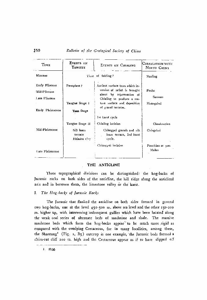
VI. Summary
The general deductions arrived at from the abôve discussions may betabulated as follows. Readers are cordially asked to take them only as tentativesuggestions. The writer does not favor the universal separation of depositionaland erosional periods as different stage, for evidently deposition and erosion wentou hand in hand within a cycle, as the land surface becoming more and moreadvanced in development. Furthermore, considering an area as a whole, deposi-tional periods of one part may be found to correlate with erosional periods ¿Lanother,
L illJ; 2. L
150
TIME
Miocetie
Early Pliocene
Mid-Pliocene
Late Pliocene
Early Pleistocene
Mid-Pleistocene
I ate Pleistocene
Bid/cuy of the Geological Society of China
EVENTS ON.YANCTEE
EVENTS ON CHIALING CORRELATION WITH
N0RTI-t CHINA
Nanliog
Fenho
Sanmen
Huangshui
Choukoutie,i
Chingshtii
Paochiao or pre-Malan
TW3 ANT1CLJNL
Three topographical divisions can be distinguished: the hog-backs of
Jurassic rocks on both sides of the anticline, the hill ridge along the anticlinalaxis and in between them, the limestone valley ¿r the karst.
I. The Hog-backs of Jurassic Rocks
The Jurassic that flanked the anticline on both sides formed in generaltwo hog-backs, one at -the level 450-500 n-L, above sea level and the other 150-200ti'. higher up, with intervening :subscqucnt gullies which have been located alongthe weak coal series of alternate beds of sandstne nd shale. The massivesandstone beds which form the hog-backs appear' to be much more rigid ascompared with the overlying Cretaccous, for in many localities, among these,the Shantung' (Fig. I, B5) outcrop is one example, 'the Jurassic beds formed aclem-cut cliff 200 m. high and the Cretaceous appear as if to have slipped off
I. tIii.
Time of folding
Pene plane Ancient surface from which in-version of relief, is broughtabout by rejuvenation of
Chialing to produce a ma-Yangtze Stage I ture surface and deposition
of gravel terraces.Yaan Stage
ist karst cycle
Yaogtze Stage H Chialing incision
Silt loam Chiangpei gravels and siltter race loam terrace, 2nd karst
Ilsiashu clay cycle.
Chiangpei Incision
Thrustfaults or faulting may of course produce si nilar effect
f4.
7'ing:Geomorphology of Chue gi ng 151
from the bedding plane of the sandstone' . The higher ridge is fairly continuousexcept where it has been breached through by transverse consequents. Such
ôreaching is at a maximum when the main rivers, such as the Chialing or theYangtze, come close to the- anticline. When severally breached the ridges tend tobecome a number of pyramid.like peaks in alignment. The sky-line of thesepeaks is sometimes ''serrated'', but in most cases they represent a morc or less
even line. The slope of the surface at the top of the hog-backs is not as steepas it should have -been. It is a rocky surface devoid of fine weathered débrisbut with detached blocks, of sandstone distributed here and there. The rockthough badly weathered only fails at the blow of a hammer, otherwise it generally.retains its shape. Hence, the general flatness of the hog-back tops is not due tothe softening effect of thick, weathered deposits, butdue to erosion, by meansaf which process the would.be angular top of the hog-backs have been truncated.
Alóng some of the transverse consequents:[which have- been able to cut.hrough the hog-backs, a tufa bed with plant fossils has been found- The datingof the tufa bed can be reasoned out from the following facts:-
that the tufa were deposited only in the valleys of the transverse
consequents which has breached thé hog-back so as to capture the drainage ofthe limestone basin beyond, Since the deposition of tufa, a periol of dissectionhas cut the tufa beds and left it standing as terraces. (e. g. at Sungchiakou2[Fig. i, B5) the dissection is m. deep); and
that the tepetate deposit within the Chiangpei conglomerate is' to be
correlated with the same period when the tributaries - of the Chialiig were'carrying a large - amount of lime in solution. It has been recognized thatthe consolidation of the Chiangpei conglomerate tookplace pari passu with itsdeposition. Hence, the tuf a deposition as well. as the breaching of the hog-backstook place during the Chialing incisn.
H. The Axial Hill Ridge
The axial hill ridge is a zone of disturlances. Thrusting and cross-faultingae of general occurrences and the rise or fall of the topographical elevation
152 Bulletin of the Geological Society of Chiea
follows closely the high or low intensity of the structure. Where the Permianwas thrust over the ridge rises higher in elevation and broader in width.Whenever the Permian pitches below the Triarsic, the axial hill ridge gradnal-becomes lower in elevation and finally disappears a the limestone valleys onboth. sides coalesce into ne. The ridge is therefore varied in height fror 580 iv.to about 700 in, . or snore aboie sea level.
There rire many consequents on both sides of the axial. hill ridge, eachgenerally has two sets of subsequents, developed respectively alolig weak beds.The stage of development of the drainage is at late youth, judging from thelittle disturbed consequent drainages.
If the axial hill ridge is carved out within the present cycle we hardlycould expect such nice adjustment of topography with structure within thtyouthful stage. It seems more probable that the adjustment was attained in aprevious cycle and that the present drainage is a new-born feature of the currentcycle. Barbour inferred from the character of anticlinal crest-lines and probabledevelopment of the Yangtze as a superposed river on a peneplane, that therewas an early stage of peneplanation after the Yenshan folding and prior fo theNanling uplift and warping (Brbour, p. 37). This peneplanation, accordingto him, may be a continuous process from the folding, only interrupted duringthe Nanling . stage, to the formation of a penepiane on the red beds (p. 37.So far as the present knowledge goes, the axial hill ridge gives no indicationof a peneplane. There may once be an ancient surface much higher above thepresent axial hills but this suggestion remains as a theory which can not beproved. Regarding Barbour's argument on the superposition of the Yangtze, itseems to the vriter that superposition can not be used as the evidence forproving the existence of a peneplane which itself is a hypothetical feature, andwhich is regarded plausible of existence by Barbour from the superposed character(Barbour, p. 48-55). There remains a poIsihility that a continuous process ofreduction of relief has taken place since the Yenshan folding and a continueduplift ever since has- been . able to prevent a stage of pneplane being reacheduntil Late Pliocene times.
III. The Ka;'r
Betweea the axial hilt ridge, if present, arid the Çurassic hog-back, there
a flatter part of ground which may be convenTcntiy termed a valley. Its:
Ting :Gcomorphology of C/lunçking 15g-
shape, outline and continuity, is far from regular, varying from a typical dolineor. "dang"' to a normal river valley.
North of the Chialing vater gap at Kuanyin gorge, the anticline has its
steep limb first on the western side then twisted over gradually to the east. The
turning point is somewhere near Wensinchang.. The dipping of the Triassicfollows closely the change. South of the water gap, the Triassic is extremelythick perhaps due to thrusting within the formation. Thus, it took only twentyminutes tó walk across from the western Triassic-Jurassic contact to rhe anticlinalaxis while one and a half of an hour is necessary to reach the eastern hog-backfrom the axis. Merely judging from the walking time may not convince one, hutthe two apparent limestone steps on the eastern side of the anticline north ofthe gap will.
Let us travel up the limestone valley along the Peichuan Railway.1 The
railway follôws the course of a subsequent river which is approximately tenmiles in length. The river cuts into the limestone floor producing three knick-points aicl associated valley in valley cross-profile along its course. Before itsfinal step a short distance downstream from Shuilanya1 (Fig. r, Cx), the rivermaintains quite an.opeñ valley. Near the locality there stood a prominent rockterrace 30 in above the river. This limestone terrace can be traced upstream tocoincide with the river bed at Maliuwan4 hence the extent of down-cuttingbetween these two points is at least 30 m. cuthng through this rOck terrace, theriver drops 210 in. within a distance of a kilometer and flowing in a narrow,V-shaped valley that was carved along a minor thrust zone, to join- the Chialingriver. Evidently this 210 m. drop of the river is connected with the Chialingincision.
One would be surprised to find that utterly different topography is .seen
on the outh-estern side of the anticline. - The limestone portion of the anticlie.is here divided into two steps, one is 8o m. higher than the other, and both ofthem is again 8o m higher than the limestone valley.of the north-western limbof the anticline. The high step (663 m.) is characterized by elongated) shallowbasins which is a common feature developed on limestone within this regionwhile in the lower step the typical "dang" topography is found. Thera are a total
1. 1i"j'; 2. 1jW; 3. 4. P?a
154 Bulletin of the Geological Society of China
nuniber of i8 "dangs" found along this step which is again subdivided into steps.A series of three "dangs" in three steps is within easy reach from Wensinchang.The "dangs" are round to oval in outline, deep and quite enclosed. TheYehchiadang' (Fig. r, Di), being the lowest, is 572 in. above sea level and isSo-roo m. in diameter, having three minor sink.holes developed along fissures on itsbasin floor. During the rainy season it is often flooded over; the water rises upinto the basin from the north-western sink-hole and drains through the south-easternone. The floor is seen to be sediniented over and rather spongy in dzy seasons,when the ''dangs" were left dry. The Small Danga is i6 m. higher, havingonly one sink-hole to drain its water.
The two major steps of the limestone seemed to be due to structuralcauses rather than lithological, for thrusting has duplicated the limestone outcropand each "copy" reaches a different stage of landform development. The lowerstep is young in the current cycle, but must have gone through more than onekarst cycle, while the higher step still linger in its advanced stage of a compara-tive speaking, earlier cycle.
South of the Kuanyin gorge, the limestone valleys on both side3 of theanticline is generally characterized by the shallow basin type. Both enclosedbasins and drained semi-basins occur, depending on whether the centripetaldrainage has or has not been captured by the lateral consequents on the Jurassichog-backs. Those which are drained appear to be the "dang" type basin withone side breached. Some of these drained basins are actually a compound basinof two or more "dangs" with their original divides dissected to form conical hillsat variable heights, determined by the extent to which it is preserved fromsolution. The highest encountered is about o m. above the basin floor. The
bareness of the hills is due to strong soil erosion and the development of lapies.In a number of places such as at Yangchiapa3 (Fig. r, B6) and Sungchiakou,the limestone valley floor has been encroached upon by headward erosion of thetransverse consequents as well as - by underground solution. At the former
locality', this encroachment has cut a deep ravine some 550 m. deep heading tothe limestone basin, On the ravine wall, there are three caves about' soo in;
below the basin floor indicating the part played by underground channelling inproducing such steep falls.
1. 2, ,J; 3.
1. 2. Îj'.
Ting:Geornorphology oJ Ghungking 155
lt is clear that prior to the current cycle, the Jurassic hog-backs are moreor less intact, until a wave of rejuvenation has affected the transverse consequentsso that the latter eroded headwards and captured the drainage of .thc "dangs",and underground capture has also asserted its influence in certain localities.
Ors the floor of those larger, shallower and elongated basins many lakesand ponds indicate the situation of dolines. There are also many localitieswhere examples of coimear drainage is found. South of Tuchiachai', a smallvalley 100-150 m. in length and ¡O-20 m. broad was cut into the basin, andthe stream drains into a cavern. These features were developed at the expenseof the older basin floor of a former karst cycle.
Above the basin floor there arc many limestone ridges capped by or laidbare of the yellow-red-clay, which formed terraces. The terraces usually are wellpreserved in localities where the encroaching consequents have not yet succeededto cut through the Jurassic hog-back. Since the headward encroaching tookplace in the current karst cycle, the sweeping of the reddish yellow clay and there-exposing the limestone floor and ridges on it, must be of recent date, whilethe clay and the limestone basin must, then, be the product of a former karstcycle.
1ack of bedding sometimes containing coarse weathered fragments oflimestone, shows that the clay is a residual deposit. But the same clay is alsofound on the axial hills of Triassic shale which, if weathered, generally gi'esrise to dark red earths and not yellowish clay. It must have been transported,though may be only a short distance, by some agents. As the clay, occurs onboth sides of the limestone basin as terraces it is possible that the deposit mayhave once filled up the who1 basin to a height almost submerged the hog-backridge.
Gravels are first reported by Y. S. Teng and Y. Y Kao. Mr. Kao givesthe localities as east of Chungchiaping2, 3î km. south of Kaotientze. Thegravels occurred on a limestone terrace which is flat It- spreads about as asheet only in an area about ¡6 square kilometers. An analysis of 50 of thepebbles gives the following datai
10 Bulletifl of tite Geological Society of China
Limestone j 8 Quartzite 7 Unknown 5
Sandstone 57 Ironstone
It is quite onvious that the gravels or rather pebbles have been greatly erodect
for they are well-worn and small, yet the composition indicates the preponderanceof local rocks, except the quartzite, which is lacking in the Red basin. Thesurface of the pebbles wears a coat of yellowish clay, evidently it musthavecome from the clay probably beihg the basal gravels of the latter. Just oppositethe terrace, fossiliferous cave-filling were recently fouhd and excavated. Accord-
ing to C. C. Young (Young, 1940), it contins remains of Stegodon tiger,etc., indicating lower Pleistocene date and can be correlated with the Wanhsiéncave deposit. The cave is sunk at a level about the same as the terrace andthe character of the deposit is the same yellowish clay that capped the limestonefloor, hence, the clay must aÏso be of lower Pleistocene age. Basing on fossilevidence of this clay and its elevation above the Sunglinpo gravel. Youngsuggests that the latter grayel is contemporaneous with the Malan loess. Evidentlyhe has taken the clay and its fossiliferous content for a river terrace similar in
origin as the Sunglinpo gravel some 200 m lower and regarding the higherthe older in age. It should be páinted out that the cave deposit is a karsticphenomenon and it may take space at any time so long as there is suitablelimestone irrespect to the level of the river. It is, therefore probable, that as
the Chialing was depositing the gravels on the Cretaceous plain, the cave mayhe developed contemporaneously on the hills and there is no reason why thekarst feature, being higher, should be older.
From what desrihed above, the history of the karst may be summarizedas follows:..
The kas st surface presents a variety of forms which generally representtwo cycles. An earlier cycle, is shown by the shallow elongated type of basin,with reddish-yellow clay in-fillings. This cycle took place in lower Pleistocenetime when, the Stegodon fauna flourished there.
Contemporaneous only in part with this karst cycle is the erosion of theCretaceous plain and the deposition of the high and low terraces on the plainSAs the Chialing incised its bed during the Ohialing stage, the transverse
Ting:Geornorphology of Chungkng 157
consequent eroded headward as a response. The headward erosion capture thekarst drainage, removed a greater part of the clay-filling and deposited tufabeds at places where the capture has taken place.
Later a slight rejuvenation exposed the Chiangpei formation. A newkarst cycle is initiated which is represented by the dolines, the "dangs'', the smallsink-holes on the basin floor and the incision of the tufas.
Postscriptum
The writer feels that the Chungking area is the key to the geomorpho-logical history of the Red basin. Owing to the limited scope of the title of thispaper, problems, such as: weather the Yangtze as well as Chialing is superposedor antecedent; how did the wave of rejuvenation migrate upstream and at whatrate is its migration; in what way may the gravels in the yellowish clayon theanticline be lerived, and whether the gap at Chingmukuan represents an ancientwater gap or not; will not be discussed here, and will be dealt with in a fewshort notes now in preparation.
RI3FERENCES
Harbour, G. B.. 193g. Physiographic History of the Yangtze, Mesn- Gcol. Sore. China, serA. No. 14
Heim, Arnold, 1931. Studies on Tectonics an Petroleum in the Vangtze Region of Tshung-king, Spccial Pub!. G4o1. Sure, of Kwanglung and Kwangsi, No. VIII.
Lee, C. Y. 1933. Development of the Upper Yangtze Valley, Bull. Geal. Soc. Chine, vol.13, p. 107-117.
1933. Mesozoic Stratigraphy of Szechuan, li5idetn, vol. 13, p.. 103-133.
Teithar'd de Chardin, P. & Young, C. C., 1935. Tha Cenozoic Sequence in the YangtieValley, Ibidem, vol. 14.
Vissmann, H. von, 1938. Loessmaking and Ice Ages in China, ¡nui. Gcog. Soc. China,vol. V.
Chen, P. F..( ¡n), 1938. 4l-476Ti
Hou, T. F. ( ) & Young, K. C. ( 1939.
tLF, P9Et. 1iV), 315.-322 Ti.
Young, C. C. f5 1940, tt; FJr,3197?6 Ti.