the government of the malagasy republic decreed … · the government of the malagasy republic...
TRANSCRIPT
2
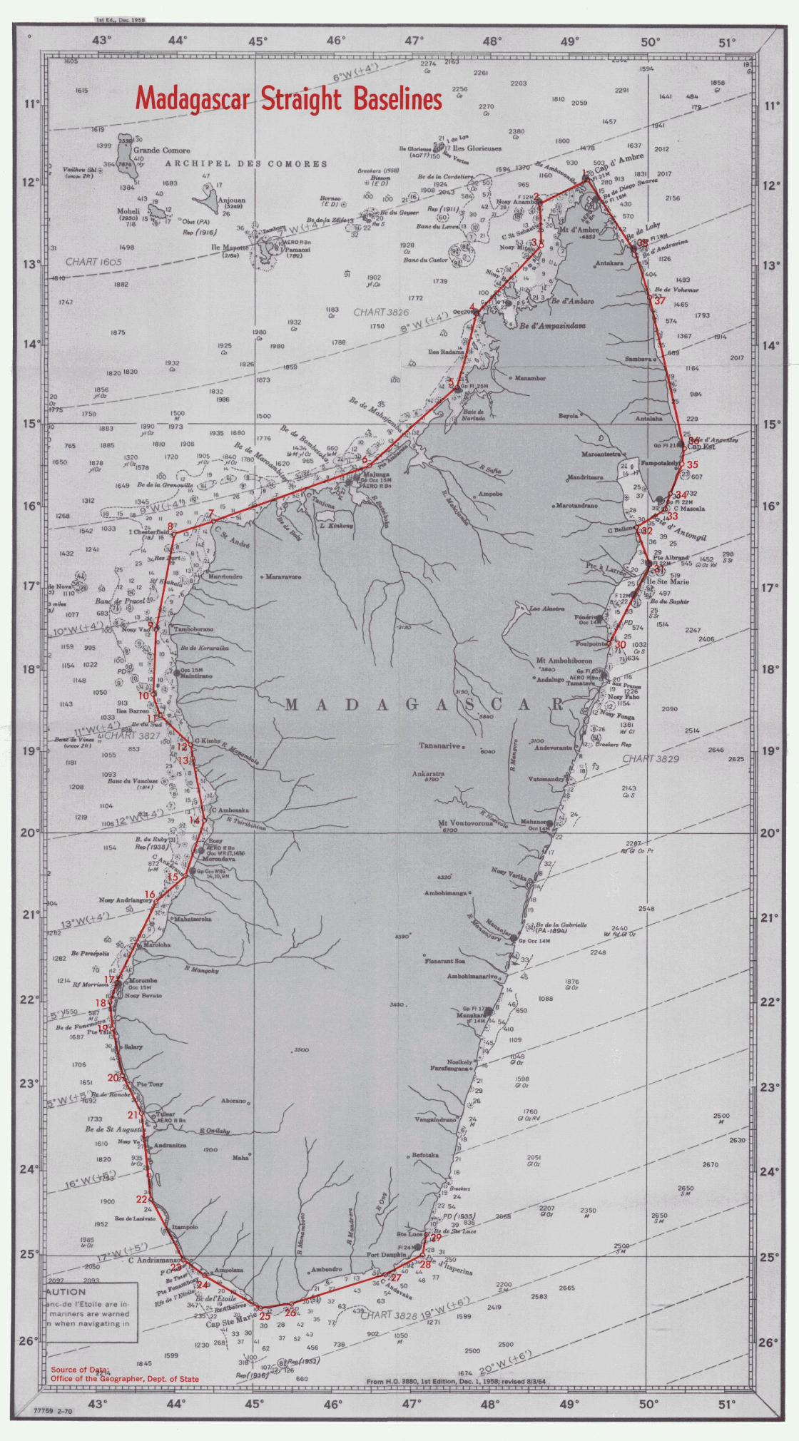
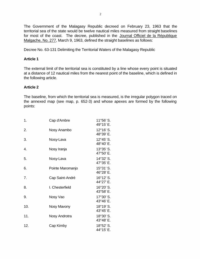
The Government of the Malagasy Republic decreed on February 23, 1963 that the territorial sea of the state would be twelve nautical miles measured from straight baselines for most of the coast. The decree, published in the Journal Officiel de la République Malgache, No. 277, March 9, 1963, defined the straight baselines as follows:
Decree No. 63-131 Delimiting the Territorial Waters of the Malagasy Republic
Article 1
The external limit of the territorial sea is constituted by a line whose every point is situated at a distance of 12 nautical miles from the nearest point of the baseline, which is defined in the following article.
Article 2
The baseline, from which the territorial sea is measured, is the irregular polygon traced on the annexed map (see map, p. 652-3) and whose apexes are formed by the following points:
1. Cap d'Ambre 11°56' S. 49°15' E.
2. Nosy Anambo 12°16' S. 48°39’ E.
3. Nosy-Lava 12°45' S. 48°40' E.
4. Nosy Iranja 13°35' S. 47°50' E.
5. Nosy-Lava 14°32' S. 47°35' E.
6. Pointe Maromanjo 15°31' S. 46°28' E.
7. Cap Saint-André 16°12' S. 44°27' E.
8. I. Chesterfield 16°20' S. 43°58' E.
9. Nosy Vao 17°30' S. 43°46' E.
10. Nosy Mavony 18°19' S. 43°45' E.
11. Nosy Androtra 18°30' S. 43°48' E.
12. Cap Kimby 18°52' S. 44°15' E.
3
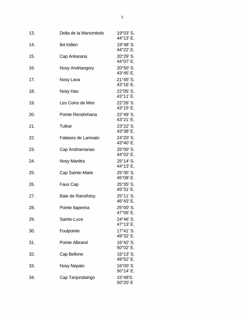
13. Delta de la Manombolo 19°03' S. 44°13' E.
14. Ilot Indien 19°48' S. 44°22’ E.
15. Cap Ankarana 20°29' S. 44°07' E.
16. Nosy Andriangory 20°50' S. 43°45' E.
17. Nosy Lava 21°45' S. 43°16' E.
18. Nosy Hao 22°05' S. 43°11' E.
19. Les Coins de Mire 22°26' S. 43°15' E.
20. Pointe Rendrehana 22°49' S. 43°21' E.
21. Tuléar 23°22' S. 43°38' E.
22. Falaises de Lanivato 24°20' S. 43°40' E.
23. Cap Andriamanao 25°00' S. 44°02' E.
24. Nosy Manitra 25°14' S. 44°13' E.
25. Cap Sainte-Marie 25°35' S. 45°08' E.
26. Faux Cap 25°35' S. 45°31' E.
27. Baie de Ranofotsy 25°11' S. 46°43' E.
28. Pointe Itaperina 25°00' S. 47°06' E.
29. Sainte-Luce 24°46' S. 47°13' E.
30. Foulpointe 17°41' S. 49°32' E.
31. Pointe Albrand 16°42' S. 50°02' E.
32. Cap Bellone 16°13' S. 49°52' E.
33. Nosy Nepato 16°00' S 50°14' E.
34. Cap Tanjondaingo 15°48'S. 50°20' E

4
35. Nosy Voara 15°28' S. 50°27' E.
36. Nosy Ngotsy 15°16' S. 50°28' E.
37. Pointe de Vohémar 13°21' S. (Harambazaha) 50°01' E.
38. Nosy Akao 12°48' S. 49°51' E.
Article 3
The baseline between consecutive points is the straight line which connects them with the exception of points 29 (Sainte-Luce) and 30 (Foulpointe) where the baseline coincides with the low-water line of the coast. …
Tananarive, 27 February 1963
The decree creates a continuous straight baseline (SBL) from point 30 counter-clockwise to point 29. The low-water mark of the intervening coast, between Points 29 and 30, which measures approximately 452 nautical miles, forms the normal baseline. The individual segments of the straight baseline are as follows: Points Distance Comments
(nautical miles)
1 – 2 40.0 The line joins the northern-most point of the island of Madagascar with an offshore island 10.5 nautical miles from mainland; deviates approximately 12° from general trend of coast which is embayed and fringed with many reefs as well as islets and rocks.
2 – 3 29.0 Two offshore islands are joined. The SBL cuts the general trend of the coast at an angle of approximately 32°.
3 – 4 70.8 Same. Angle to the general trend of the coast is 10°.
4 – 5 58.0 Same. Coastline is indented and fringed with approximately 16 islands and islets as well as with large patches of reef. Identical with general trend of coast.
5 – 6 86.0 Joins offshore island to mainland; encloses two deep legal bays; virtually no islands. SBL within 2° of general trend of coast.
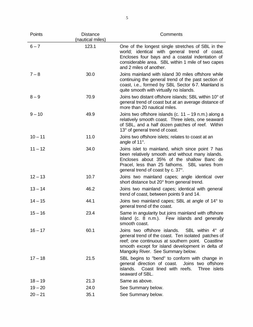
5
Points Distance Comments (nautical miles)
6 – 7
7 – 8
8 – 9
9 – 10
10 – 11
11 – 12
12 – 13
13 – 14
14 – 15
15 – 16
16 – 17
17 – 18
18 – 19 19 – 20 20 – 21
123.1
30.0
70.9
49.9
11.0
34.0
10.7
46.2
44.1
23.4
60.1
21.5
21.3 24.0 35.1
One of the longest single stretches of SBL in the world; identical with general trend of coast.Encloses four bays and a coastal indentation of considerable area. SBL within 1 mile of two capes and 2 miles of another.Joins mainland with island 30 miles offshore while continuing the general trend of the past section of coast, i.e., formed by SBL Sector 6-7. Mainland is quite smooth with virtually no islands.Joins two distant offshore islands; SBL within 10° of general trend of coast but at an average distance of more than 20 nautical miles.Joins two offshore islands (c. 11 – 19 n.m.) along a relatively smooth coast. Three islets, one seaward of SBL, and a half dozen patches of reef. Within 13° of general trend of coast.Joins two offshore islets; relates to coast at an angle of 11°.Joins islet to mainland, which since point 7 has been relatively smooth and without many islands. Encloses about 35% of the shallow Banc dePracel, less than 25 fathoms. SBL varies from general trend of coast by c. 37°.Joins two mainland capes; angle identical overshort distance but 20° from general trend.Joins two mainland capes; identical with general trend of coast, between points 9 and 14.Joins two mainland capes; SBL at angle of 14° to general trend of the coast.Same in angularity but joins mainland with offshore island (c. 8 n.m.). Few islands and generallysmooth coast.Joins two offshore islands. SBL within 4° of general trend of the coast. Ten isolated patches of reef; one continuous at southern point. Coastline smooth except for island development in delta of Mangoky River. See Summary below.SBL begins to "bend" to conform with change in general direction of coast. Joins two offshoreislands. Coast lined with reefs. Three isletsseaward of SBL.Same as above.See Summary below.See Summary below.
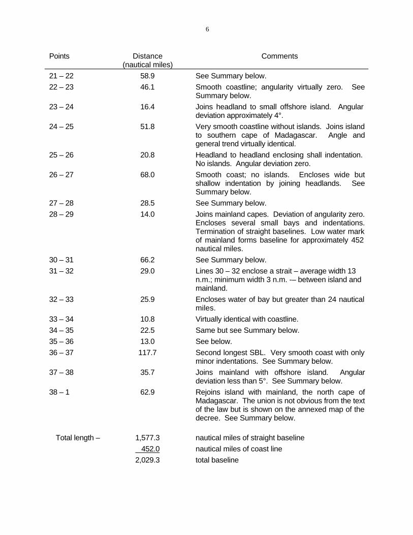
6
Points Distance Comments (nautical miles)
21 – 22 58.9 22 – 23 46.1
23 – 24 16.4
24 – 25 51.8
25 – 26 20.8
26 – 27 68.0
27 – 28 28.5 28 – 29 14.0
30 – 31 66.2 31 – 32 29.0
32 – 33 25.9
33 – 34 10.8 34 – 35 22.5 35 – 36 13.0 36 – 37 117.7
37 – 38 35.7
38 – 1 62.9
Total length – 1,577.3 452.0
2,029.3
See Summary below.Smooth coastline; angularity virtually zero. SeeSummary below.Joins headland to small offshore island. Angular deviation approximately 4°.Very smooth coastline without islands. Joins island to southern cape of Madagascar. Angle andgeneral trend virtually identical.Headland to headland enclosing shall indentation. No islands. Angular deviation zero.Smooth coast; no islands. Encloses wide butshallow indentation by joining headlands. SeeSummary below.See Summary below.Joins mainland capes. Deviation of angularity zero. Encloses several small bays and indentations.Termination of straight baselines. Low water mark of mainland forms baseline for approximately 452 nautical miles.See Summary below.Lines 30 – 32 enclose a strait – average width 13 n.m.; minimum width 3 n.m. -– between island and mainland.Encloses water of bay but greater than 24 nautical miles.Virtually identical with coastline.Same but see Summary below.See below.Second longest SBL. Very smooth coast with only minor indentations. See Summary below.Joins mainland with offshore island. Angulardeviation less than 5°. See Summary below.Rejoins island with mainland, the north cape ofMadagascar. The union is not obvious from the text of the law but is shown on the annexed map of the decree. See Summary below.
nautical miles of straight baseline
nautical miles of coast line
total baseline
7
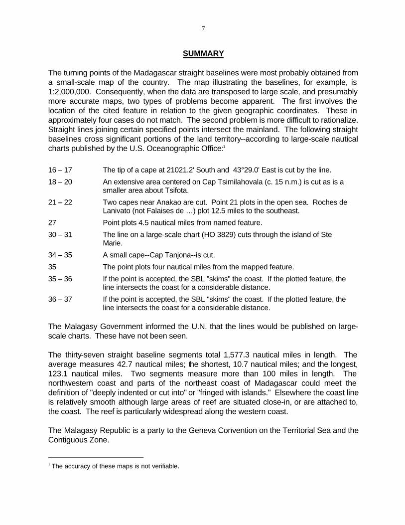
SUMMARY
The turning points of the Madagascar straight baselines were most probably obtained from a small-scale map of the country. The map illustrating the baselines, for example, is 1:2,000,000. Consequently, when the data are transposed to large scale, and presumably more accurate maps, two types of problems become apparent. The first involves the location of the cited feature in relation to the given geographic coordinates. These in approximately four cases do not match. The second problem is more difficult to rationalize. Straight lines joining certain specified points intersect the mainland. The following straight baselines cross significant portions of the land territory--according to large-scale nautical charts published by the U.S. Oceanographic Office:1
16 – 17 The tip of a cape at 21021.2' South and 43°29.0' East is cut by the line.
18 – 20 An extensive area centered on Cap Tsimilahovala (c. 15 n.m.) is cut as is a smaller area about Tsifota.
21 – 22 Two capes near Anakao are cut. Point 21 plots in the open sea. Roches de Lanivato (not Falaises de …) plot 12.5 miles to the southeast.
27 Point plots 4.5 nautical miles from named feature.
30 – 31 The line on a large-scale chart (HO 3829) cuts through the island of Ste Marie.
34 – 35 A small cape--Cap Tanjona--is cut.
35 The point plots four nautical miles from the mapped feature.
35 – 36 If the point is accepted, the SBL "skims" the coast. If the plotted feature, the line intersects the coast for a considerable distance.
36 – 37 If the point is accepted, the SBL "skims" the coast. If the plotted feature, the line intersects the coast for a considerable distance.
The Malagasy Government informed the U.N. that the lines would be published on large-scale charts. These have not been seen.
The thirty-seven straight baseline segments total 1,577.3 nautical miles in length. The average measures 42.7 nautical miles; the shortest, 10.7 nautical miles; and the longest, 123.1 nautical miles. Two segments measure more than 100 miles in length. The northwestern coast and parts of the northeast coast of Madagascar could meet the definition of "deeply indented or cut into" or "fringed with islands." Elsewhere the coast line is relatively smooth although large areas of reef are situated close-in, or are attached to, the coast. The reef is particularly widespread along the western coast.
The Malagasy Republic is a party to the Geneva Convention on the Territorial Sea and the Contiguous Zone.
1 The accuracy of these maps is not verifiable.