the gps toolkit: world class open source software tools...
TRANSCRIPT

THE GPS TOOLKIT: WORLD CLASS OPEN SOURCE SOFTWARE TOOLS FOR THE
GNSS RESEARCH COMMUNITY
Salazar, D., Hernandez-Pajares, M., Juan-Zornoza, M., and Sanz-Subirana, J.Grupo de Astronomia y Geomatica (gAGE)Universitat Politecnica de Catalunya08034 [email protected]
Keywords: GNSS data processing software GPSTk.
Abstract
The ”GPS Toolkit” (GPSTk) project is an advanced GNSS Open Source Software (GOSS) suite initiatedby the Applied Research Laboratories of the University of Texas (ARL:UT), aiming to provide a worldclass GNSS library computing suite to the satellite navigation community.
The objective of this work is to show how the GPSTk suite may be used to rapidly and easily develop,implement and test advanced GNSS data processing applications in a flexible way. The main characteristicsand modules of the GPSTk are also presented, as well as the current trends in its development.
Results from the GNSS data processing carried out with the examples introduced in this work are shown,as well as a brief comparison with an established GPS software package such as BRUS.
1 Introduction
The ”GPS Toolkit” (GPSTk) project is an advanced GNSS Open Source Software (GOSS) suite initiatedby the Applied Research Laboratories of the University of Texas (ARL:UT), aiming to provide a worldclass GNSS library computing suite to the satellite navigation community.
In this regard, one of the main goals of the GPSTk is to free the research community from implementingcommon GNSS algorithms, providing a publicly accessible software repository where those algorithms maybe found and freely used.
The initial code of the GPSTk was released in summer 2004 and presented at the ION-GNSS-2004 [1],and its functionality has been continuously improving. A very brief list of the tools provided by theGPSTk includes: Handling of observation data and ephemeris in RINEX and SP3 formats, mathematical,statistical, Matrix and Vector algorithms, time handling and conversions, ionospheric and troposphericmodels, cycle slip detection and correction, etc.
As a typical Open Source project, the GPSTk is released under the GNU LGPL license, allowing freedomto develop both commercial and non-commercial software based on it, and it is actively maintained by adozen developers around the world using the Internet as communication medium. Development facilitiesare provided by the popular SourceForge open source application repository, and a website of the projectmay be found in http://gpstk.sourceforge.net.
The GPSTk software suite consists of a core library and extra applications. The library provides severalfunctions that solve processing problems associated with GNSS (for instance, using RINEX files) and isthe basis for more advanced applications distributed as part of the GPSTk suite.
Apart from the library, the GPSTk suite comes with a wealth of GNSS applications ready to run, exploreand include in new developments. Full applications may be found in the ”gpstk/dev/apps” subdirectory,and interesting and easy-to-follow examples of use are located at ”gpstk/dev/examples”.
A very important feature of a project of this nature is documentation. In this regard, the GPSTk is

profusely documented using the Doxygen documentation system and it is heavily based on object-orientedprogramming principles, ensuring a modular, extensible and maintainable code.
1.1 GPSTk portability
One of the important characteristics of the GPSTk is its wide portability. The GPSTk is a highly platform-independent software code base thanks to the use of the ANSI C++ programming language.
In this regard, it is reported to run on the following operative systems:
• Unix family: Linux, Solaris, AIX, etc.
• Windows.
• Mac OS X.
Also, it may be compiled using several versions of free and commercial compilers, both in 32 bits and 64bits PC platforms.
Besides, it is even reported to run in such disparate platforms as the Nokia 770 Internet Tablet (seeFigure 1) and the Gumstix line of full function miniature computers (see Figure 2), weighting just 8 g,where the author (an active GPSTk developer) has successfully accomplished GNSS data processing usingthe GPSTk [2].
Figure 1: Nokia 770 Internet Tablet plotting GPS data
Figure 2: Gumstix Full Function Miniature Computer

2 GPSTk functionality
The GPSTk library provides several different modules grouping the classes by common functions. Table 1summarizes some of the the most important and used classes. Please note that currently the data processingis limited to pseudorange processing.
3 Writing GPSTk-based applications
One of the great advantages of the GPSTk is its flexibility and ease of use. In this section, such flexibilitywill be emphasized by taking an example application that comes included in the GPSTk and adapting it,with very little effort, to do several kinds of GNSS pseudorange processing.
As previously stated, we will take an example (”example5.cpp”) and will quickly modify it to get severaldifferent GNSS pseudorange processing strategies. Three new examples will then be developed:
• example-a.cpp: This program will process C1 pseudoranges applying an standard ionospheric model(Klobuchar model, using the ionospheric coefficients broadcasted in the GPS navigation message, asdescribed in [3]), a simple tropospheric model (described in [4] and [5]), and the solution will be foundusing a standard Least-Mean-Squares algorithm.
• example-b.cpp: An improvement with respect to the former one, it will process C1 pseudorangesand apply Klobuchar ionospheric model, but the tropospheric model will be the one described in theRTCA/DO-229C document (called the ”Minimum Operational Performance Standards” or ”MOPS”).The solution will be found using the Weighted-Least-Mean-Squares algorithm also described in theaforementioned document.
It is worth noting that the MOPS algorithms are used in SBAS systems receivers such as EGNOSones, but this example will not apply further EGNOS corrections because they are not currentlyimplemented in GPSTk.
• example-c.cpp: Very similar to ”example-b.cpp”, but in this case the ionospheric-free combinationpseudoranges (PC) are used, and therefore the ionospheric model is dropped. Tropospheric and solveralgorithms remain the same (MOPS).
All these programs will read the observables and ephemeris data from corresponding RINEX files. Broadcastephemeris will be used (although simple changes allow for using SP3 ephemeris, described in [6]) and theoutput will be epoch (in seconds of day) and deviations in latitude, longitude and height (in meters) froma nominal position. The full source code for these examples may be found at [7].
In order to show the flexibility and ease of use of the GPSTk, in the following lines you will find thecode added to ”example5.cpp” in order to allow ”example-a.cpp”, ”example-b.cpp” and ”example-c.cpp”to output the data in the format explained above:
// Object holding nominal position for EBRE station
Position nominalPos(4833520.2269, 41537.00768, 4147461.489);
Position diffPos; // Object to hold difference in position
// Get the difference between epoch solution and nominal position
diffPos = solPos - nominalPos;
// Azimuth of solution with respect to nominal
double azimuth = nominalPos.azimuthGeodetic(solPos);
// Elevation of solution with respect to nominal
double elev = nominalPos.elevationGeodetic(solPos);
double magnitude = RSS(diffPos.X(), diffPos.Y(), diffPos.Z() // Compute RSS
// Print results

FUNCTION CLASS NAME REMARKS
Time handling ANSITime ”Seconds since Unix epoch” representationCivilTime Common year/month/day/hour/min/sec time representationDayTime Time representation for all common formats, including GPS
Formatted I/O FFStream Formatted File StreamFFData Formatted File DataRinexObsStream I/O on RINEX Observation filesRinexNavStream I/O on RINEX Navigation filesRinexMetStream I/O on RINEX Meteorological filesSP3Stream I/O on SP3 files
Atmosphere models IonoModel Klobuchar ionospheric modelSimpleTropModel Simple Black tropospheric modelSaasTropModel Saastamoinen tropospheric modelNBTropModel New Brunswick tropospheric modelGGTropModel Goad and Goodman tropospheric modelMOPSTropModel Minimum Operational Performance Standards tropospheric model
Ephemeris EngAlmanac Almanac information for the GPS constellationEngEphemeris Ephemeris information for a single satelliteRinexEphemerisStore Interface to read Rinex Navigation dataSP3EphemerisStore Interface to read SP3 Navigation data
Solution algorithms Bancroft Algebraic algorithm to get an initial guess of GPS receiver’s positionModeledPR Compute modeled pseudoranges from satellites to a given receiverPRSolution Compute a position and time solution using RAIM conceptsDOP Encapsulates the computation of Dilution Of PrecisionSimpleIURAWeight Assigns weights to satellites based on their URA Index (IURA)MOPSWeight Assigns weights to satellites based on the Appendix J of MOPS C
Mathematical tools Vector Mathematical vector representationMatrix Mathematical matrix representationSVD Singular value decomposition of a matrixLUDecomp Performs the lower/upper triangular decomposition of a matrixCholesky Computes the Cholesky decomposition of the given matrixPolyFit Computes a polynomial fitRungeKutta4 Provides a collection of integration routinesStats Conventional statistics for one sampleTwoSampleStats Conventional statistics for two samplesExpression Solves general mathematical expressions at run timeSolverLMS Computes the Least Mean Squares Solution of a given equations setSolverWMS Computes the Weighted Least Mean Squares Solution of given set
Coordinates ECEF Earth centered, Earth fixed geodetic coordinates in metersPosition Common 3D geographic position formats representationTriple Three-dimensional vectorsXvt Earth centered, Earth fixed position/velocity/clock representationGPSGeoid Geodetic model defined in ICD-GPS-200WGS84Geoid Geodetic model defined in NIMA TR8350.2
Miscellanea CommandOption Set of several command line optionsBasicFramework Basic framework for programs in the GPS ToolkitException Base class for all exception objectsFileFilter Sorts and filters file dataFileHunter Finds files matching specified criteria
Table 1: Some important GPSTk classes

cout << rData.time.DOYsecond() << " "; // Epoch in seconds of day
// Longitude change
cout << magnitude*sin(azimuth*DEG_TO_RAD)*cos(elev*DEG_TO_RAD) << " ";
// Latitude change
cout << magnitude*cos(azimuth*DEG_TO_RAD)*cos(elev*DEG_TO_RAD) << " ";
cout << magnitude*sin(elev*DEG_TO_RAD) << " "; // Altitude change
GPSTk’s objects encapsulate much of the functionality needed to carry out common tasks in GNSS dataprocessing. Several details are worth noting regarding the previous sample code:
• A Position object named ”nominalPos” is declared in order to hold the nominal position, which inthis case is also set simultaneously in ECEF coordinates.
• Another Position object named ”diffPos” is also declared, in order to hold the difference between the”solution position” (solPos) and the nominal one.
• Note how the substraction (”-”) operator is overloaded in the ”Position” objects in order to allowthem to be easily handled (diffPos = solPos - nominalPos).
• Position objects encapsulate several handy methods to operate on them. For instance, the relativeazimuth and elevation between the nominal position and the solution position are founded using themethods azimuthGeodetic() and elevationGeodetic(), respectively.
• When printing the results, please pay attention to the method used in the DayTime object rData.time
in order to easily get the proper output format: DOYsecond().
As could be seen, in a very short code sample several very handy GPSTk characteristics were easily andeffectively used in order to get the job done. There are plenty of features like these in the GPSTk.
Other small modifications remain in order to allow the original example ”example-5.cpp” to fulfill therequisites stated above for ”example-a.cpp”:
• Declare an object ”gcatTM” of class ”GCATTropModel” (tropospheric modelling).
• Declare object ”solver” belonging to class ”SolverLMS” (standard Least-Mean-Squares algorithm).
In the other hand, the main modifications to convert ”example-a.cpp” into ”example-b.cpp” include:
• Tropospheric modelling will be carried out by object ”mopsTM” of class ”MOPSTropModel.
• ”solver” object now must belong to class ”SolverWMS” (Weighted-Least-Mean-Squares algorithm).
• A new object, ”mopsWeights” belonging to ”MOPSWeight” class, must be added to compute weights.
Some minor details remain (for example, ”mopsTM” needs to be initialized and ”solver” invocation mustinclude a vector of weights supplied by ”mopsWeights.weightsVector”), but it is very easy to change froma processing strategy to another thanks to the GPSTk encapsulation of important algorithms.
Finally, the change from ”example-b.cpp” to ”example-c.cpp” involves mainly three simple modifications:
• Object obsC1, originally belonging to class ”ExtractC1”, must now be declared as belonging to”ExtractPC”.
• Given that the Total Group Delay is not applicable when using PC observables, the object in chargeof modeling the pseudoranges (”modelPR”, of class ” ModeledPR”) will be configured to ignore theTGD (modelPR.useTGD = false).
• All references to Klobuchar ionospheric modelling are now useless and should be deleted.

In summary, just some small changes were all what was needed in order to quickly implement severaldifferent GNSS data processing strategies, taking as starting point an example provided by the GPSTk.
The results produced by these example programs are shown in the following figures. Figure 3 plots thevertical error regarding the nominal position as a function of time for EBRE station, January 30th, 2002.Figure 4 shows the horizontal error for the same station and day, with the corresponding RMS values foreach strategy. The results are consistent with what is expected from these processing strategies.
Figure 3: Vertical error for different processing strategies. EBRE 2002/01/30.
4 Validation with BRUS at positioning and range domains
For validation purposes, in this section the data results from one of the aforementioned example programs(example-b) will be compared with the results yielded by the BRUS software package.
The ”Basic Research Utilities for SBAS” or BRUS [8] is a software package developed by gAGE/UPC anddesigned to be compliant with RTCA/MOPS Do 229A/B/C [9]. BRUS has been used since January 2002in the ESTB Data Collection and Evaluation project of EUROCONTROL to process and analyze weeklydata sets. Hence, it is a tested software suitable for comparison purposes.
BRUS in composed of three different parts: B2AConv (Binary to ASCII GPS measurements converter),BNAV (BRUS-NAVIGATOR) and BNAL (BRUS-NAVIGATION-ANALYZER). In particular, the partrelevant to our comparison is the navigation module BNAV. Version 3.2.1 was used.
Given that BRUS/BNAV is able to process all the EGNOS messages, and it does it in many differentconfigurations, and in the other hand the GPSTk does not have yet implemented the modules regardingEGNOS messages, then BNAL was configured to ignore EGNOS messages and only implement the MOPSstandards regarding modeling.
4.1 Validation at positioning domain
In order to compare the results, a first approach has been to compute the vertical and horizontal positioningerrors for two different fixed GPS stations at different times:

Figure 4: Horizontal error for different processing strategies. EBRE 2002/01/30.
• Station EBRE (middle latitude) at 2002/01/30.
• Station COCO (ecuatorial latitude) at 2000/07/26.
In Figure 5 can be seen how the GPSTk-based program match very well with BRUS, typically better thanseveral centimeters, for the vertical error at EBRE. The main differences, specially at the end of the dataset, are due to satellites being dropped by ”example-b” before being dropped by BRUS.
On the other hand, Figure 6 shows a similar agreement in horizontal error at EBRE. The same can be seenfor vertical (Figure 7) and horizontal (Figure 8) errors for COCO station.
4.2 Validation at range domain
Another approach to compare the results has been to plot the modeling of some important parameters fora given station, time span and satellite. In this case the modeling data for ionosphere effects and PrefitResiduals were generated for EBRE station and satellite PRN #14 at 2002/01/30. Also, the differencesbetween GPSTk and BRUS/BNAV modeling in both cases (ionosphere and prefits) are also showed.
As can be seen in the plots in Figure 9 and Figure 10, the modeling is very close (within 1 mm) in bothsoftware suites for the slant Klobuchar ionospheric modeling.
The comparison of Prefit Residuals is important because they combine the information of all modelingalgorithms. In this case, Figure 11 and Figure 12 show that the agreement is remarkably good: Differencesbetween Prefits Residuals are within 1 mm, confirming that the applied algorithms are equivalent.
5 Current trends of development
Several lines of work are being currently pursued by the GPSTk developers around the world. Supportfor new formats such as RINEX 3.0 and BINEX is under way, as well as a rewrite of the support for timerecords and conversions [10].

Figure 5: Comparison of vertical error between example-b and BRUS. EBRE 2002/01/30.
Figure 6: Comparison of horizontal error between example-b and BRUS. EBRE 2002/01/30.

Figure 7: Comparison of vertical error between example-b and BRUS. COCO 2000/07/26.
Figure 8: Comparison of horizontal error between example-b and BRUS. COCO 2000/07/26.
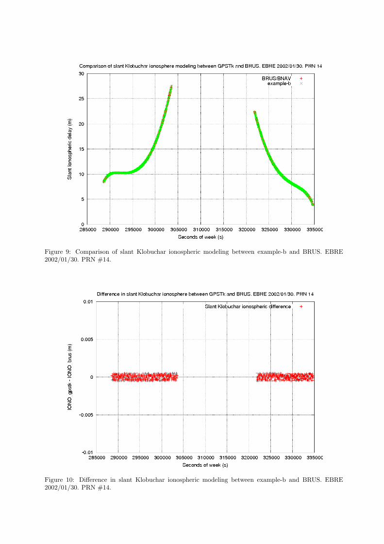
Figure 9: Comparison of slant Klobuchar ionospheric modeling between example-b and BRUS. EBRE2002/01/30. PRN #14.
Figure 10: Difference in slant Klobuchar ionospheric modeling between example-b and BRUS. EBRE2002/01/30. PRN #14.

Figure 11: Comparison of Prefit Residuals modeling between example-b and BRUS. EBRE 2002/01/30.PRN #14.
Figure 12: Difference in Prefit Residuals between example-b and BRUS. EBRE 2002/01/30. PRN #14.

Besides, a unified way to handle GNSS processing data is currently under discussion in the developers maillist. Also, work (by the first author of this manuscript) to add support for phase processing and associatedmodels (aiming to achieve Precise Point Positioning) is expected to start at January 2007.
6 Conclusions
In this work, the main characteristics and modules of the GPSTk have been presented, as well as thecurrent lines of work on its development.
Also, several examples of GNSS data processing were easily and quickly set up taking as starting pointan example code provided by the GPSTk itself. This has showed how to implement and test GNSS dataprocessing applications in a very flexible way.
Finally, the validation with BRUS/BNAV has also been presented, showing an excellent agreement bothin the positioning domain (vertical and horizontal components of error for a couple stations at differentlatitudes and epochs) and in the modeling data. This confirms the viability of the GPSTk as a source codebase for developing reliable GNSS data processing software.
References
[1] B. Tolman et al., 2004. The GPS Toolkit – Open Source GPS Software. Proceedings 17th InternationalTechnical Meeting of the Satellite Division of the ION (ION GNSS 2004). Long Beach, California.
[2] D. Salazar, M. Hernandez-Pajares, J.M. Juan and J. Sanz. 2006 Rapid Open Source GPS softwaredevelopment for modern embedded systems: Using the GPSTk with the Gumstix. 3rd. ESA Workshopon Satellite Navigation User Equipment Technologies NAVITEC ’2006. Noordwijk, The Netherlands.
[3] ARINC Research Corp. 2000 Navstar GPS Space Segment / Navigation User Interfaces (ICD-GPS-200).
[4] H. D. Black, A. Eisner. 1984. Correcting Satellite Doppler Data for Tropospheric Effects. Journal ofGeophysical Research. Vol 89.
[5] M. Hernandez-Pajares, J.M. Juan and J. Sanz. 2001 GPS Data Processing: Code and Phase.Algorithms, Techniques and Recipes. gAGE/UPC. Barcelona. Spain. 2001. Available at website:http://gage14.upc.es/BOOK/
[6] S. Hilla. 2006 The Extended Standard Product 3 Orbit Format (SP3-c).http://igscb.jpl.nasa.gov/igscb/data/format/sp3c.txt
[7] D. Salazar. Examples for the GPSTk and the Gumstix. Website: http://nacc.upc.es/gpstk/gumstix/
[8] M. Hernandez-Pajares, J.M. Juan, J. Sanz, X. Prats and J. Baeta. 2003 Basic Research Utilities forSBAS (BRUS). 5th Geomatics Week. Barcelona. Spain.
[9] RTCA Minimal Operational Performance Standards for GPS/WAAS Airborne Equipment. Doc. No.Do 229A. June 1998.
[10] B. Renfro at al. 2005 The Open Source GPS Toolkit: A Review of the First Year. Proceedings ofthe 18th International Technical Meeting of the Satellite Division of the Institute of Navigation (IONGNSS 2005). Long Beach, California.