the grand village of the natchez indians was indeed …
TRANSCRIPT

9
THE GRAND VILLAGE OF THE NATCHEZ INDIANS WAS INDEED GRANDA Reconsideration of the Fatherland Site Landscape
Ian W. Brown and Vincas P. Steponaitis
The Fatherland site, located near the city of Natchez, Mississippi, is one of the best- known ar chaeo logi cal sites in the Ameri can South (Figure 9.1). It was the Grand Village of the Natchez Indians, home to chiefs who held the titles Great Sun and Tattooed Serpent. Dramatic accounts of numerous French colonists brought these people to life for European readers, as they related the intricate story of French- Indian relations in colonial Louisiane. There never seems to have been a question as to where the Grand Village was located. As a consequence, it has been a prime source for under stand-ing the relationship between the colonial- era and precolonial Indians, as ar-chaeologists work from the known to the unknown in the region. As such, Fatherland played a major role in James Ford’s Analysis of Indian Village Site Collections from Louisiana and Mississippi (1936:59–64). Moreau B. Cham-bers, Ford’s partner in Mississippi archaeology, excavated a series of buri-als from the site that helped Ford formulate what historic Natchez Indian material culture looked like. George Quimby (1942) later drew heavily from findings at this site when he wrote his major study on Natchezan pottery.
Later still, Fatherland was the subject of two monographs by Robert S. Neitzel. His first book (1965) concentrates on exploring the three surviv-ing mounds at Fatherland, two of which he dated to the eighteenth cen-tury, and his sec ond (1983) deals mainly with the remains of wooden build-ings in and around the plaza. The small number of buildings made sense, as this was a ritual and po liti cal center. One mound supported the resi-dence of the chief, the other a temple, and between the two mounds was a plaza where ceremonies took place. History and archaeology were in agreement, so one might wonder just what use there may be in devoting further attention to Fatherland, especially as there have been no recent excavations there. Our purpose here is to bring attention to some early docu-ments that merit further study. We examine a 1723 map drawn by Ignace- François Broutin and compare it with an anonymous 1730 map showing the

THE GRAND VILLAGE OF THE NATCHEZ INDIANS / 183
French siege of the site following the Natchez Uprising. The Broutin map, in particular, indicates that the Grand Village landscape was far more com-plex than supposed by twentieth- century investigators. We also consider several nineteenth- century texts that refer to the Fatherland site, because they shed light on the number of mounds that existed there and on a fea-ture of the landscape that puzzled Neitzel.
Background
Let us start with some background on the site itself and its importance in South ern Indian history. As stated, in the early eighteenth century Father-land was the capital of the Natchez nation, and thus it received great atten-tion in the writings of Le Page du Pratz (1758, 1972), Dumont de Montigny
Figure 9.1. Modern map of the Fatherland site, showing the three surviving mounds and the approximate location of a buried feature, which Neitzel interpreted as an embankment associated with the French siege trench (adapted from Barnett 2007: Figure 6 and Neitzel 1978: Figure 1b).
184 / BROWN AND STEPONAITIS
(1753, 2012), and other French writers, most of whom are quoted in great detail in John R. Swanton’s 1911 landmark study (see also Delanglez 1935; French 1869; Giraud 1974; McWilliams 1988; Miller Surrey 2006; Rowland and Sanders 1927, 1929; Rowland et al. 1984a, 1984b). The Natchez Indi-ans were among the last manifestations of the Plaquemine culture in the lower Mississippi Valley (Barnett 1998, 2007; Brain 1978; Brown 1985, 1998b, 1998d, 2007; Oswalt and Neely 1996; Quimby 1942; Stern 1977). European explorers were fascinated by the complex social and po liti cal structure mani-fested by the inhabitants of the Natchez Bluffs, and their detailed descrip-tions of Natchez society provided considerable fodder for historians and anthropologists for many years to come (Albrecht 1946, 1948; Brain 1971; Brown 1982, 1989, 1990, 1992; Clayton et al. 1993; Fischer 1964; Hart 1943; Knight 1990; Loren 1995; Lorenz 1997; Quimby 1946; Steponaitis 1978:421–423; Tooker 1963; White et al. 1971).
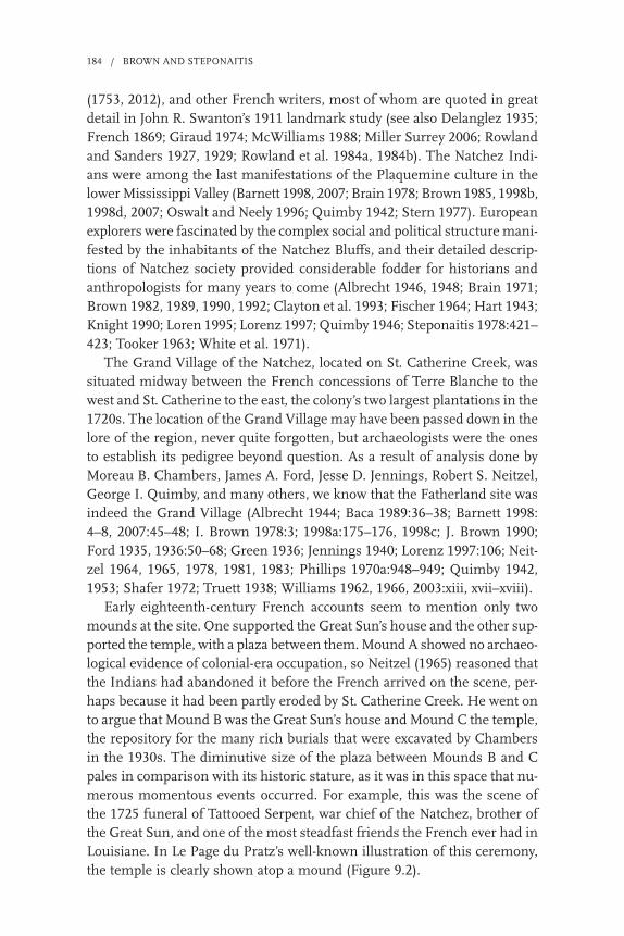
The Grand Village of the Natchez, located on St. Catherine Creek, was situated midway between the French concessions of Terre Blanche to the west and St. Catherine to the east, the colony’s two largest plantations in the 1720s. The location of the Grand Village may have been passed down in the lore of the region, never quite forgotten, but archaeologists were the ones to establish its pedigree beyond question. As a result of analy sis done by Moreau B. Chambers, James A. Ford, Jesse D. Jennings, Robert S. Neitzel, George I. Quimby, and many others, we know that the Fatherland site was indeed the Grand Village (Albrecht 1944; Baca 1989:36–38; Barnett 1998: 4–8, 2007: 45–48; I. Brown 1978:3; 1998a: 175–176, 1998c; J. Brown 1990; Ford 1935, 1936: 50–68; Green 1936; Jennings 1940; Lorenz 1997:106; Neit-zel 1964, 1965, 1978, 1981, 1983; Phillips 1970a: 948–949; Quimby 1942, 1953; Shafer 1972; Truett 1938; Williams 1962, 1966, 2003:xiii, xvii–xviii).
Early eighteenth- century French accounts seem to mention only two mounds at the site. One supported the Great Sun’s house and the other sup-ported the temple, with a plaza between them. Mound A showed no ar chaeo-logi cal evidence of colonial- era occupation, so Neitzel (1965) reasoned that the Indians had abandoned it before the French arrived on the scene, per-haps because it had been partly eroded by St. Catherine Creek. He went on to argue that Mound B was the Great Sun’s house and Mound C the temple, the repository for the many rich burials that were excavated by Chambers in the 1930s. The diminutive size of the plaza between Mounds B and C pales in comparison with its historic stature, as it was in this space that nu-merous momentous events occurred. For example, this was the scene of the 1725 funeral of Tattooed Serpent, war chief of the Natchez, brother of the Great Sun, and one of the most steadfast friends the French ever had in Louisiane. In Le Page du Pratz’s well- known illustration of this ceremony, the temple is clearly shown atop a mound (Figure 9.2).

THE GRAND VILLAGE OF THE NATCHEZ INDIANS / 185
Neitzel’s investigations of Mounds A, B, and C revealed that the Father-land site had considerable time depth (1965). Although the site was the habitation of the Great Sun and his retainers in the late seventeenth and eighteenth centuries, it is doubtful that it had been the paramount Natche-zan center for very long (Brain 1978:360–361; Brown 2007). Nevertheless, Fatherland seems to have been occupied to some extent, without any ob-vious breaks, for more than five centuries before its abandonment in 1730 (Brown 1998c). Although there was significant habitation at Fatherland dur-ing the Anna phase, between A.D. 1200 and 1350, mound construction does not appear to have begun until the following Foster phase, between A.D. 1350 and 1500. Additions continued to be made to the Fatherland mounds during the Emerald phase, between A.D. 1500 and 1650, and it is most likely during that time span that Fatherland attained its status as the capi-tal. In earlier times the much larger Emerald and Anna sites were probably the paramount centers of the Natchez chiefdom (Beasley 2007; Brain 1978; Brown 2007; Cotter 1951).
In addition to social changes, the Natchez region experienced consider-able physical changes over the years. For example, during his 1972 excava-
Figure 9.2. Funeral of the Tattooed Serpent in 1725 (Le Page du Pratz 1758:3: facing p. 55).

186 / BROWN AND STEPONAITIS
tions Neitzel was hard- pressed to find the 1730 surface at the Grand Vil-lage. He eventually found it, well into the season, almost 2 m below the present ground level (Figure 9.3). Neitzel (1978) attributes this great accu-mulation of soil deposition to nineteenth- century deforestation. As trees were felled, both for expansion of arable land and for stoking the furnaces of hundreds of steamboats, the land paid a horrible price. Year after year abundant rainfall eroded the loam, lowering bluffs and choking bayous in the process. When the course of St. Catherine Creek was purposefully short-ened, causing it to flow west into the Mississippi River, the gradient of the stream greatly increased. St. Catherine Creek and its many tributaries cut deeply into the land, and a constant creep of soil covered evidence of ear-lier occupations along St. Catherine’s banks, laying a thick mantle of sedi-ment above early occupation zones at sites like Fatherland.
Neitzel also noticed something else while digging at the Grand Village in 1972. Between Mound B and C, he observed what appeared to be a buried ridge, the result of a great deal of earth movement (see fig ure 9.1). Neitzel (1978) interpreted this feature as part of a siege trench dug in February of 1730 by the French army, which had returned to punish the Natchez for the previous No vem ber’s uprising. The basis for this interpretation was a French military map of the siege (see fig ure 9.5), which we will discuss in more detail presently. In trying to reconcile this map with the ar chaeo logi cal record at Fatherland, Neitzel was faced with a dilemma: rather than show-ing three mounds in a linear arrangement as in fig ure 9.1, the military map depicted four mounds in a diamond pattern. In an extended argument too long to recount here, Neitzel explained away this discrepancy by suggest-ing that the north arrow on the military map was off by 90 degrees, that is, that the map’s north arrow actually pointed east. This change in orientation, he argued, together with some understandable confusion on the part of the
Figure 9.3. Idealized diagram of stratification in the plaza at Fatherland (Neitzel 1983: Figure 5; courtesy of Mississippi Department of Archives and History).
THE GRAND VILLAGE OF THE NATCHEZ INDIANS / 187
cartographer in adding a fourth mound, was sufficient to account for the differences between the French map and Fatherland’s modern appearance.
Our analy sis of the French maps, in clud ing two that were not available to Neitzel at the time of his study, leads us to a different and more parsi-monious explanation; to wit, that the Grand Village had more than three mounds, which obviates the need to invoke errors by the anonymous map-maker. Furthermore, nineteenth- century descriptions of the Fatherland site indicate that the ridge between the mounds was actually an artificial levee built to prevent flooding, rather than a military fortification connected with the French siege. We now consider each line of evidence in turn.
Eighteenth- Century French Maps
Perhaps the best- known maps of French colonial Natchez are an engraving and four manuscripts by Jean- François- Benjamin Dumont de Montigny.1 All are oblique views, drawn in Dumont’s cartoonish style, and none de-pict any mounds at the Grand Village. Their general lack of detail, as well as a lack of consistency among his maps in the details they do show, clearly indicates they were impressionistic sketches, not measured drawings (see Litschi 2011 for a useful summary of the manuscripts). Dumont was never a stickler for precision, so his renderings of the Grand Village tell us little about what it may have looked like.2
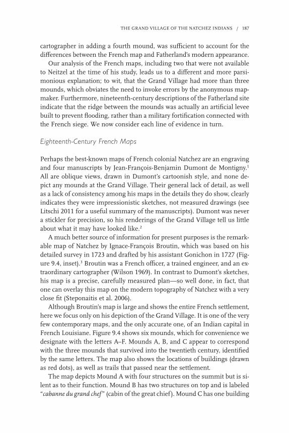
A much better source of information for present purposes is the remark-able map of Natchez by Ignace- François Broutin, which was based on his detailed survey in 1723 and drafted by his assistant Gonichon in 1727 (Fig-ure 9.4, inset).3 Broutin was a French officer, a trained engineer, and an ex-traordinary cartographer (Wilson 1969). In contrast to Dumont’s sketches, his map is a precise, carefully measured plan—so well done, in fact, that one can overlay this map on the modern topography of Natchez with a very close fit (Steponaitis et al. 2006).
Although Broutin’s map is large and shows the entire French settlement, here we focus only on his depiction of the Grand Village. It is one of the very few contemporary maps, and the only accurate one, of an Indian capital in French Louisiane. Figure 9.4 shows six mounds, which for convenience we designate with the letters A–F. Mounds A, B, and C appear to correspond with the three mounds that survived into the twentieth century, identified by the same letters. The map also shows the locations of buildings (drawn as red dots), as well as trails that passed near the settlement.
The map depicts Mound A with four structures on the summit but is si-lent as to their function. Mound B has two structures on top and is labeled “cabanne du grand chef ” (cabin of the great chief ). Mound C has one building

188 / BROWN AND STEPONAITIS
called “temple neuf ” (new temple), and Mound D also has one building with the caption “vieux temple” (old temple). The two remaining mounds, E and F, have no buildings. The map confirms contemporary descriptions of the Grand Village as having very few houses (e.g., Swanton 1911:158, 190–191).
In addition to these architectural details, Broutin provides valuable in-formation on how the land in the immediate vicinity of the mounds was used. The open area bounded by Mounds B, C, D, and E—essentially the area between the chief ’s cabin and the two temples—has no trails running through it, consistent with the long- standing idea that it was a ceremonial
Figure 9.4. Detail from Broutin’s 1723 map of the Natchez settlements, showing the Grand Village, rotated with north at the top. The mounds are labeled A–F. Mounds A, B, and C correspond to the modern mounds with the same designations. Mound descriptions as they appear on the map: Mound B, cabin of the great chief (“cabanne du grand chef”); Mound C, new temple (“temple neuf”); Mound D, old temple (“vieux temple”). Inset at upper left shows the full map with area of detail outlined, north at lower left (adapted from Bibliothèque nationale de France, Département des cartes et plans, Ge DD 2987–8834B).

THE GRAND VILLAGE OF THE NATCHEZ INDIANS / 189
plaza. The area enclosed by Mounds A, B, and F, however, is crisscrossed with paths, suggesting that it lacked such a special function. Yet another in-teresting feature is the large cultivated area indicated by tiles of dashed par-allel lines, located just southeast of Mounds A and B on the map.
Broutin’s map not only gives us a fascinating glimpse of the Grand Vil-lage while still in use, but also provides the key to resolving Neitzel’s co-nundrum in identifying the mounds mapped there during the 1730 siege (Neitzel 1978:29–33, 1983:46–50). Before we solve this mystery, we discuss in more detail the two existing maps that show the siege.
The better- known siege map, and the one Neitzel discussed at length, “Plans des Deux Forts Natchez,” is currently housed in the Bibliothèque nationale de France.4 It depicts four mounds, two Indian forts, and French batteries and siege works (Figure 9.5). The map is unsigned, but Neitzel
Figure 9.5. Anonymous 1730 map of the French siege at Natchez, showing four mounds along with the French and Indian fortifications. North arrow points right (adapted from Bibliothèque nationale de France, Estampes, Vd 21 [3] Fol.).

190 / BROWN AND STEPONAITIS
(1983:48) attributes it to a Lt. de Niné—a misreading of a poorly written por-tion of text, “et dessiné” (and drawn), in the cartouche. For now we simply refer to this manuscript as anonymous.5
The sec ond manuscript map, “Plan de la Guerre des Natchez,” now at The Historic New Orleans Collection, only recently came to light (Fig ure 9.6; Greenwald 2013: Plate 22).6 It was drawn by Marc- Antoine Caillot, a clerk for the Company of the Indies who lived in New Orleans from July 1729 to April 1731 (Greenwald 2013:xxii–xxix). Although Caillot was in Louisiane during the 1730 siege at Natchez, he never left New Orleans, so there can be little doubt that the siege map he made to illustrate his memoir was a copy, presumably from an origi nal document available to him in the capital.
Despite minor differences in the coverage and the labeling of features, the two siege maps are very similar, particularly in the layout of the mounds. This layout, when compared with that in Broutin’s earlier map, provides the solution to Neitzel’s dilemma. Figures 9.7 and 9.8 show the corresponding areas in the Broutin 1723 and the anonymous 1730 maps, resized to the same scale and rotated with north at the top. Note that the relative locations of Mounds B, C, D, and E are identical. On both maps, Mound D is labeled
Figure 9.6. Caillot’s 1730 map of the French siege at Natchez. North is toward the bottom (The Historic New Orleans Collection, acc. no. 2005.0011).

THE GRAND VILLAGE OF THE NATCHEZ INDIANS / 191
as the old temple (“vieux temple” in 1723 and “vieux temple abandonné” in 1730) and Mound C is marked as the current temple (“temple neuf” and “temple des Natchez,” respectively), so the mound descriptions fit perfectly. The surrounding landscape features are also generally similar, particularly the lobe in the terrace edge north of Mound B. Mounds A and F are not depicted in the anonymous map, probably because neither was involved in the siege; the location of A is obscured by the cartouche, and F would have straddled the neatline along the east ern edge. The Caillot map also lacks Mounds A and F, as both fall outside its east ern boundary. This correlation among the maps, if it holds true, leads to several interesting implications.
First and foremost, there were more mounds at the Grand Village than currently meet the eye, or that were mentioned in the early accounts (Fig-ure 9.9). As stated, the two mounds that supported the chief ’s cabin and the temple are consistently mentioned in the eighteenth- century narratives, and three mounds are visible today. Yet the cartographic evidence suggests six mounds existed in 1723, four of which had wooden buildings on their summits and two of which did not. Three of the mounds with buildings can be identified as to function. One supported the cabin of the chief (B), another the new temple (C), and a third the old temple (D). The presence of two temples at the Grand Village is interesting in light of a Natchez story recounted by Le Page du Pratz (Swanton 1911:170–171; see also Neitzel 1965:63), which makes reference to an old and a new temple and may have served as a charter myth for such an arrangement.
Second, the north arrow on the anonymous 1730 map is actually cor-rect (cf. Neitzel 1978: Figure 1a). Neitzel was understandably led to argue otherwise because he lacked the information from the 1723 map and could not have known which mounds were depicted on the 1730 map—for ex-ample, that Mound A was missing and that two additional mounds were being shown.
Third, the French siege works and Indian forts can now be more accu-rately placed (see fig ure 9.9). The French approach trenches and batteries would have been located well north and west of Mounds B and C, not be-tween these mounds as Neitzel argued (cf. 1978: Figure 1b, 1983:47–50). The two Natchez forts, which the trenches were designed to attack, were located west of the Grand Village, not to the south as previously believed (cf. Neitzel 1978: Figure 1a). Whether any portions of these forts have sur-vived the erosion caused by St. Catherine Creek and twentieth- century de-velopment in the area remains to be seen.
Finally, the cartographic evidence confirms Neitzel’s identifications of Mound B as the chief ’s residence and Mound C as a temple (1965:64–85). The suggestion that Mound A was abandoned by the 1720s, perhaps because it was eroding into the creek, no longer holds true (cf. Neitzel 1965:64). The

192 / BROWN AND STEPONAITIS
1723 map shows this mound intact with four unidentified buildings on top and the creek rather far away.
A puzzle still remains, however. If the siege line was located north and west of the plaza marked by Mound B and C, what exactly did Neitzel dis-cover in the plaza in his 1972 excavations? Clearly there was a ridge, but if it was not the French siege line, then what was it? For that, we must turn to a number of nineteenth- century scholars who left written descriptions of the ever- changing landscape of the Fatherland site.
Nineteenth- Century Descriptions
Montroville Dickeson was a colorful man by any definition—an antiquarian who loved to dig, to collect, and to speculate. He commissioned a renowned panorama, which he used to entertain the masses with the glories of prehis-
Figure 9.7. Detail from Broutin’s 1723 map, oriented with north at the top and with the modern mound designations A to E added. The map is shown at the same scale as Figure 9.8 (adapted from the origi nal).

THE GRAND VILLAGE OF THE NATCHEZ INDIANS / 193
tory (Culin 1900; McDermott 1958:170–172). Although he explored widely in the lower Mississippi Valley, Natchez was a constant draw for him, as he wrote many reports on its ar chaeo logi cal productivity in a magazine called The Lotus. In 1842, on one such exploration in Natchez, he spent a consid-erable amount of time digging mounds on Colonel Bingaman’s plantation, which contained the Fatherland site. Dickeson’s (1848) account of this work in The Lotus provides a fine description of what the site looked like a little more than 170 years ago.7 Of interest to the present study is his reference to an embankment, more than 2 m high, which connected the mounds:
In July, 1842, accompanied by a friend, I drove to the plantation of Col. A. L. Bingaman, situated two miles [3.2 km] east of the town of Natchez. . . . On the west ern bank of the St. Catharine stand three
Figure 9.8. Detail from the anonymous 1730 map, oriented with north at the top and with the modern mound designations A to E added. The map is trimmed at its neatline and shown at the same scale as Figure 9.7 (adapted from the origi nal).
194 / BROWN AND STEPONAITIS
Aborigi nal tumuli; equi- distant from each other. The largest is twenty feet [7.6 m] in height and ninety feet [27.4 m] at base, and its form as nearly as we could determine, a rectangular pyramid. On the west side stand five large red elm trees, the largest upwards of three feet [.9 m] in diameter. The other two [mounds] being so much defaced by the sundry examinations, destroying entirely their origi nal fig ure, but the Colonel informed me since, if his memory served him cor-rectly, they were origi nally all of the same angles. The distance be-tween each is fifty yards [45.7 m].
At present, they [the mounds] are united by a bank or line eight feet [2.4 m] high and twelve feet [3.7 m] at base, the soil of which has been chiefly taken from the north side of one of the small mounds, by the present proprietor, to protect the cotton crop from the destructive
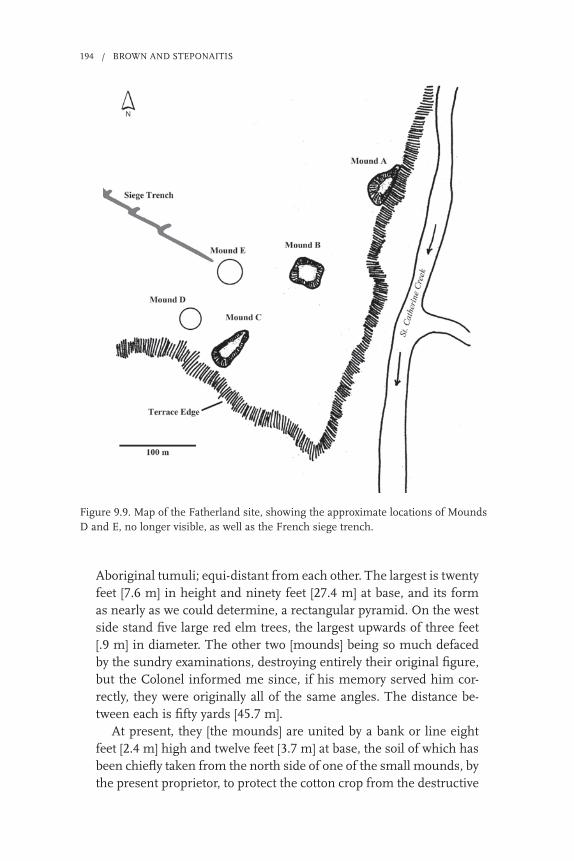
Figure 9.9. Map of the Fatherland site, showing the approximate locations of Mounds D and E, no longer visible, as well as the French siege trench.

THE GRAND VILLAGE OF THE NATCHEZ INDIANS / 195
effects of an overflow from the St. Catherine, which runs in torrents shortly after an extensive rain. The west sides of the smaller mounds were covered with a small growth which deprived us, in a measure, of making a thorough examination. [Dickeson 1848:129–130]
This account makes clear that an artificial levee was raised between at least some of the surviving mounds at Fatherland, so as to keep St. Catherine Creek from flooding the cotton fields. To create this levee, the builders carved away portions of the mounds as sources of fill for construction.
The overseer for Bingaman’s plantation provided Dickeson with both a work force and tools to dig the mounds: “We all repaired to the spot, and after taking their proper dimensions, and a sketch of the outlines of the group, we set our force to work. The overseer informed us, that in digging away the west side of one of the small mounds, to form the bank or levee, several fine terra cotta vases and jugs, highly ornamented, were found, and in every instance lying around the head and neck of the skeleton. Several of these were presented to the Rev. Mr. Chase, by the wife of the overseer, the others were in the possession of the blacks on the plantation, from whom we purchased them at their own price” [Dickeson 1848:130]. It is important to note in this passage that the “west side of one of the small mounds” was removed to form the levee, whereas in the previous quotation the “north side of one of the small mounds” was excavated. The first passage also men tioned that “the west sides of the smaller mounds were covered with a small growth which deprived us, in a measure, of making a thorough ex-amination.” Such dense vegetation is typical of recently disturbed ground and may have grown up after the earth removals he mentioned. In short, the edges of the mounds—perhaps all three that Dickeson saw—were al-ready reduced by the early 1840s.
Dickeson also wrote of several mounds that stood apart from the three just described: “The open flank, to the west of the group, has been guarded by several smaller circular mounds, which has been cut down by a con-tinued series of cultivation; but their outlines are readily seen after a re-cent ploughing. North of the main group stands a mound of considerable size, this contains a few bones, much decayed, and we thought of Choc-taws from their burial. This was evidently used as an outpost” (Dickeson 1848:130). The two mounds “to the west of the group” were undoubtedly D and E. Although he said they were destroyed by cultivation, one cannot help but suspect that borrowing earth to construct the levee also played a role.
Dickeson’s mention of a large mound to the north of the main group is of some interest, as it probably corresponds to Mound F. He continues: “A few years prior to my investigation, the extreme north ern mound was

196 / BROWN AND STEPONAITIS
partially examined by Dr. Powell, a distinguished phrenologist of the west, who obtained three crania. Two of the three were heads of Choctaws, a male and a female, which had been placed there within the remembrance of the proprietor, who informed me that the female head was that of a very beau-tiful Indian girl, not over twenty years old, who died while on a visit from her nation. Since the desertion of this part of the state by the Choctaws, it has been a custom for small tribes with their petty chiefs to visit annu-ally Natchez, and barter their wares, skins, mocasins, &c., &c.” (Dickeson 1848:130).8 Whether or not these skulls were actually of people from Choc-taw towns, it is fascinating that Indians may have been burying their dead in Natchez mounds as late as the first decades of the nineteenth century.9 Dickeson says this mound was of considerable size, but no trace of it ex-ists today. Its location on Broutin’s map has long since been swallowed by St. Catherine Creek.
The Dr. Powell that Dickeson mentions is an interesting character—one William Byrd Powell, author of the 1856 book on The Natural History of the Human Temperaments. From the introduction to this volume, we learn that Powell was active in the South in 1835, when he gave a series of lec-tures at the Medical College of Louisiana. At one point he states, “During the course, we demonstrated the truth of our doctrines by crania furnished by the class” (Powell 1856:11). One wonders whether the Fatherland skulls were included among the instructional crania.
Before leaving the nineteenth century, it is worth considering the exploits of another local scholar—Benjamin L. C. Wailes, who served as Mississip-pi’s first state geologist (Sydnor 1938). Wailes was very interested in the ar-chaeology of Mississippi and recorded many sites during the years he was employed by the state (Brown 1998a; Wailes 1843–1862, 1852/1854). Fol-lowing a visit made on March 2, 1853, he noted a number of mounds on Bingaman’s plantation. The levee that Dickeson described 11 years earlier clearly had been breached by the time Wailes made his study:
At St. Catherine, near the bridge, up the creek ¼ of a mile [.4 km], is the group of mounds, three in number, the site of an old indian vil-lage. The largest is highest up the creek and near the bank. They all seem to have been square or rectangular. The largest is some ten or 15 ft [4.6 m] high and seem to have been about one hundred ft [30.5 m] square on the top. All have been much modified and dug away, the earth taken to form a levee along the creek from mound to mound to protect the bottom fields from overflow of the creek, but without success; a recent freshet has covered a large portion of the flat and left large quantities of mud or silt spread over it. A few bones and a

THE GRAND VILLAGE OF THE NATCHEZ INDIANS / 197
little pottery were seen on the sides of the mounds where the earth had been dug away . . . the larger mound with a group of large elm trees growing on the north ern, the north ern side remains of its origi-nal form and dimensions. The outline of the other sides can be rec-ognized, but the earth has been removed considerably by the plow, the washing of the rains and the overflow of the creek. Mound B. shows also a part of one side in its origi nal state, but more than half of it has been removed by digging down the sides. The small and lowest mound C. has already been entirely destroyed. [Wailes 1853, in Brown 1996:15–16]
It is clear that the number of mounds had diminished since Dickeson explored the site, as Wailes’s description corresponds to the way the Father-land site appeared through out the following century. Of particular interest, however, is Wailes’s comment with regard to soil movement, wherein he says, “A recent freshet has covered a large portion of the flat and left large quantities of mud or silt spread over it.” We believe that event was not unique and explains why soil accumulated to such great depth at the site and why it proved so troublesome to Neitzel in his 1972 excavations. The levee that ran from mound to mound is undoubtedly the earthwork that Neitzel en-countered (see fig ure 9.1), and the one that he mistakenly attributed to the French.
Summary and Conclusions
Based on a study of French colonial maps—some only recently discovered—and a fresh look at nineteenth- century texts, we have come up with a more accurate view of the early eighteenth- century landscape of the Grand Vil-lage. What the site looked like earlier is anyone’s guess, but it is reasonably clear now that there were origi nally at least six mounds at the site and that half of them disappeared in the mid- nineteenth century as a result of le-vee building and erosion.
We can now describe and compare the mounds as they appear on the maps. Doing so yields insights on their functions both before and during the siege (Table 9.1; Figures 9.1, 9.10, 9.11). Some of the descriptive la-bels applied to the mounds refer to how they were used by the Indians, and others to how they were employed by the French. Let us consider each mound in turn.
Mound A only appears on the Broutin 1723 map and was not involved at all in the siege. However, we now know it was occupied his tori cally, as it had three square buildings on its summit and one smaller round structure.

198 / BROWN AND STEPONAITIS
Mound B is depicted in 1723 with two buildings on its summit, which Broutin called the cabin of the great chief (“cabanne du grand chef”). It is therefore interesting that both 1730 siege maps show nothing on top. Both are silent as to this earthwork’s function, and Caillot’s map simply labels it a mound (“butte”). Whether the chief ’s house had been dismantled be-fore the siege, or the building was omitted because it played no role in the battle, we may never know.
Mound C is consistently topped by a building in all three maps. This structure is called the new temple (“temple neuf”) by Broutin, the Natchez temple (“temple des Natchez”) on the anonymous map, and the army’s head-quarters (“corps de l’armée”) by Caillot. The clear implication is that the Nat-chez temple was repurposed as the French command post during the siege, a conclusion supported by his tori cal accounts that state the French com-mander took up residence there (Charlevoix 1872:98; Claiborne 1880:46; Merveilleux 2003:17; Rowland and Sanders 1927:78; cf.). Both siege maps show the summit encircled by a parapet, undoubtedly built by the French.10
Mound D is also consistently shown with a building called the old temple by Broutin and the old abandoned temple by the anonymous cartographer. On Caillot’s map, however, it is marked “les blessez” (the injured), which im-
Table 9.1. Mounds Shown on French Maps
Broutin 1723 Anonymous 1730 Caillot 1730
Buildings Description Buildings Description Buildings Description
Mound A 4 (none) — — — —
Mound B 2 cabanne du grand chef (cabin of the great chief )
0 (none) 0 butte (mound)
Mound C 1 temple neuf (new temple)
1 temple des Nat-chez (Natchez temple)
1 corps de l’armée (head-quarters)
Mound D 1 vieux temple (old temple)
1 vieux temple abandonné (old abandoned temple)
1 les blessez (the injured)
Mound E 0 (none) 0 batterie de 2 pièces (two-piece battery)
0 temple des Natchez (Nat-chez temple)
Mound F 0 (none) — — — —
THE GRAND VILLAGE OF THE NATCHEZ INDIANS / 199
plies the French converted it to a field hospital. If the structure was weather-tight enough to be used in this way, it clearly had not been abandoned by the Indians for very long, if at all.11
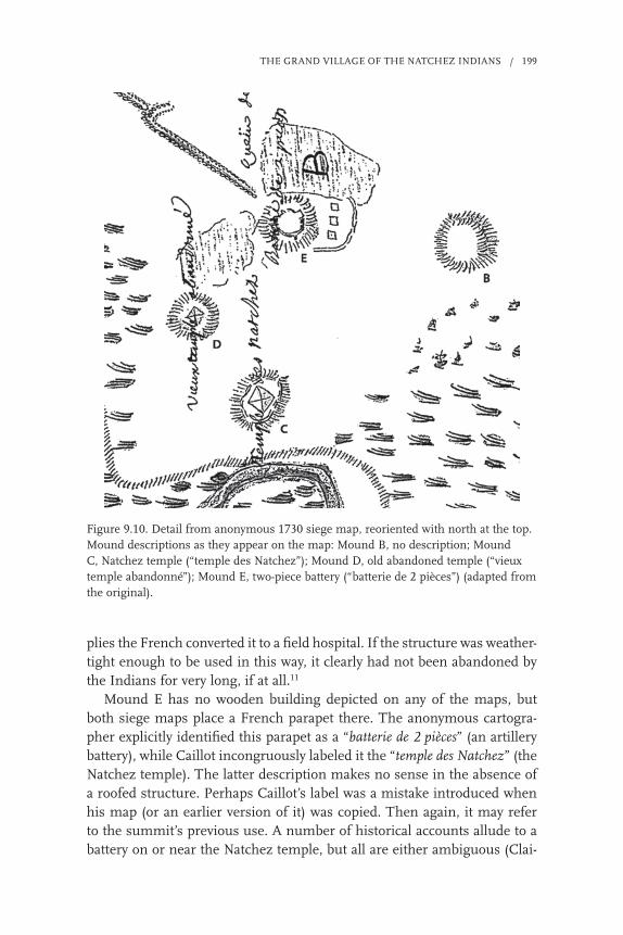
Mound E has no wooden building depicted on any of the maps, but both siege maps place a French parapet there. The anonymous cartogra-pher explicitly identified this parapet as a “batterie de 2 pièces” (an artillery battery), while Caillot incongruously labeled it the “temple des Natchez” (the Natchez temple). The latter description makes no sense in the absence of a roofed structure. Perhaps Caillot’s label was a mistake introduced when his map (or an earlier version of it) was copied. Then again, it may refer to the summit’s previous use. A number of his tori cal accounts allude to a battery on or near the Natchez temple, but all are either ambiguous (Clai-
Figure 9.10. Detail from anonymous 1730 siege map, reoriented with north at the top. Mound descriptions as they appear on the map: Mound B, no description; Mound C, Natchez temple (“temple des Natchez”); Mound D, old abandoned temple (“vieux temple abandonné”); Mound E, two- piece battery (“batterie de 2 pièces”) (adapted from the origi nal).
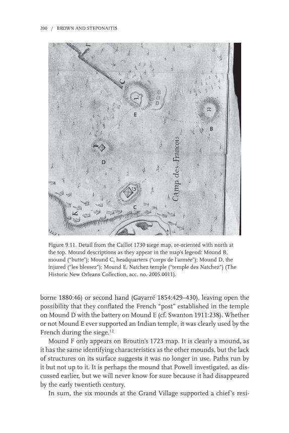
200 / BROWN AND STEPONAITIS
borne 1880:46) or sec ond hand (Gayarré 1854:429–430), leaving open the possibility that they conflated the French “post” established in the temple on Mound D with the battery on Mound E (cf. Swanton 1911:238). Whether or not Mound E ever supported an Indian temple, it was clearly used by the French during the siege.12
Mound F only appears on Broutin’s 1723 map. It is clearly a mound, as it has the same identifying characteristics as the other mounds, but the lack of structures on its surface suggests it was no longer in use. Paths run by it but not up to it. It is perhaps the mound that Powell investigated, as dis-cussed earlier, but we will never know for sure because it had disappeared by the early twentieth century.
In sum, the six mounds at the Grand Village supported a chief ’s resi-
Figure 9.11. Detail from the Caillot 1730 siege map, re- oriented with north at the top. Mound descriptions as they appear in the map’s legend: Mound B, mound (“butte”); Mound C, headquarters (“corps de l’armée”); Mound D, the injured (“les blessez”); Mound E, Natchez temple (“temple des Natchez”) (The Historic New Orleans Collection, acc. no. 2005.0011).

THE GRAND VILLAGE OF THE NATCHEZ INDIANS / 201
dence, at least two temples, and several wooden structures of unknown functions. From maps generated in 1723 and 1730, we know that at least some of the mound summits were bare, and one (Mound B) may have lost its building in the interim. During the 1730 siege, three of the mounds were commandeered by the French for use as a headquarters, a field hospital, and an artillery emplacement, an act the Indians undoubtedly viewed as a desecration (Barnett 2007:116). At some time in the mid- nineteenth cen-tury these mounds fed into the economy of the region. Whereas the Indi-ans valued them for their sanctity, the new inhabitants saw them merely as sources of soil and scientific amusement. Three of the mounds (D, E, and F) disappeared completely and the other three (A, B, and C) were badly dam-aged.13 Earth borrowed from several contributed to a massive levee, the fea-ture Neitzel detected in his excavations but did not quite understand. New data have helped solve the riddle and, at the same time, shed light on this amazingly complex and interesting site. The Grand Village itself truly was grand and around its periphery are stories yet to be told.
Acknowledgments
Our thanks go to James Barnett, James Brown, Kathleen DuVal, Erin Green-wald, Elizabeth Jones, David Morgan, and to the volume editors for their help and useful comments. In addition, we will always be grateful to Robert S. Neitzel, who was a great mentor and friend to both of us as we began our careers in archaeology. It feels good to finally solve a puzzle that so vexed him as he dug Fatherland in the summer of 1972, when we all shared a field house on the bluff in Natchez.
Notes
1. The engraving was published in Dumont’s Mémoires historiques sur la Louisiane (1753, vol. 2: facing p. 94). The four manuscripts were drawn in Dumont’s own hand, all in the 1740s: “Fort Rozalie des Natchez,” Service historique de la Défense, Département de l’Armée de Terre, Etat- Major 7C 211 (Neitzel 1983: Plate Ia); “Carte du Fort Rozalie des Natchez François,” Archives nationales, Paris, Cartes et Plans, N III Louisiane 1/2 (Neitzel 1983: Plate Ib); “Carte de la Disposition des Maisons des Habitants Francois des Natchez,” from “Poème en vers touchant l’établissement de la province de la Louisiane,” 1744, Bibliothèque nationale de France, Arsenal, MS- 3459 (Villiers 1931: Figure 43); and “Carte du Fort Rozalie des Natches Francois avec ses Dependances et Village des Sauvages,” from “Memoire de Lxx Dxx Officiere Ingenieur,” 1747, Newberry Library, vault oversize Ayer MS 257 map 9 (Dumont 2012: Plate 4). Detailed images of all are posted online at Early Maps of the Ameri can South, http://rla.unc.edu/emas/local- settl.html.
2. In addition to these holograph maps, there exists an unsigned manuscript that is of-ten attributed to Dumont (Green 1936: Plate 1): “Carte Particulière des Natchez Établi par
202 / BROWN AND STEPONAITIS
les François et Détruit par les Sauvages du Dit Lieu en 1729,” Service historique de la Défense, département Marine, Cartes et plans, recueil 68, no. 60, formerly in Bibliothèque de la Service hydrographique, 4044C- 48. This map is drawn by a different hand and in a style somewhat different from Dumont’s. Even so, this map so resembles Dumont’s holograph maps in the content and layout that a relationship is undeniable. One possi-bility is that it was a copy made by (or for) the cartographer Phillipe Buache, with whom Dumont collaborated in the early 1750s (Sayre 2012:41). See Early Maps of the Ameri can South, http://rla.unc.edu/emas/local- settl.html.
3. The map is titled “Carte des Environs du Fort Rosalie aux Natchez” (Bibliothèque nationale de France, Département des cartes et plans, Ge DD 2987–8834B). Although long listed in a published finding aid (Leland 1932:228) and mentioned in an article by Samuel Wilson (1982:201), this map drew little attention from scholars until a de-tailed scan was posted online by the Bibliothèque nationale in 2007 (http://gallica.bnf.fr/ark:/12148/btv1b530530625). The map was then rediscovered by Joseph V. Frank, who brought it to our attention. We are also grateful to Elizabeth Jones for her help in trans-lating portions of this map.
4. The full title is “Plans des Deux Forts des Natchez Assiégés au Mois de Février 1730 Par les Français / Tchactas Tonicas Colapissas et Oumas / La Présente Carte Levée sur les Lieux à L’Estime / Faite et Dessinée a la N.lle Orleans Le Six Avril / Mil Sept Cent Trente” (Bibliothèque nationale de France, Estampes, Vd 21 (3) Fol.). Neitzel (1983: Plate IIa) published an inverted photograph of this map, consistent with his idea that the north arrow was wrong (see also Neitzel 1978: Figure 1a).
5. We know that Broutin sent a map of the 1730 siege to Maurepas in Paris, as did Étienne de Périer, the governor of Louisiane (Rowland and Sanders 1927:72, 135). Of the two men, Broutin is the one who took part in the siege and was an excellent cartogra-pher. Hence, it is plausible, indeed likely, that he made one or both of these maps. The anonymous map under consideration here was clearly not drafted by Broutin, as the handwriting in the cartouche does not match his neat and distinctive script. Of course, it was not at all unusual for manuscript maps to be copied, in which case the handwrit-ing would match that of the draftsman rather than the cartographer. The designations of the temple buildings on the mounds in the anonymous 1730 map are similar to those on Broutin’s 1723 map and imply that the cartographer knew of their use before the siege—a knowledge that Broutin certainly possessed. All in all, the evidence of Broutin’s author-ship is suggestive but not definitive. It is also worth noting that this map uses letter la-bels (A, B, and C) that are not explained in a legend, the kind of error one might expect in a hastily drawn copy.
6. Caillot’s map is called “Plan de la Guerre des Natchez” and is bound as an illus-tration in his manuscript memoir titled “Relation du Voyage de la Louisianne ou Nouvelle France fait par Sr. Caillot en l’Annee 1730” (The Historic New Orleans Collection, MSS 596). This remarkable memoir surfaced about a decade ago and was acquired at auction by The Historic New Orleans Collection in 2005. It has recently been published in trans-lation (Greenwald 2013; the map appears as Plate 22). A detailed comparison of Caillot’s drawing with the anonymous siege map reveals some interesting differences. The anony-mous map covers a much larger area than Caillot’s, but the latter is not simply a subset of the former. Rather, each map includes some territory that the other lacks, with Cail-lot’s drawing extending farther to the west, and the anonymous one farther to the north, east, and south. This pattern suggests that both maps are copies descended from a larger origi nal. Although the general configuration of the two maps is very similar, they are

THE GRAND VILLAGE OF THE NATCHEZ INDIANS / 203
different in some details, in clud ing the labels applied to some of the mounds (see table 9.1) and the locations of some of the Indian camps. For example, the anonymous map places the “camp des Chactas” (Choctaw camp) to the northeast of the mounds, whereas Caillot’s map places it to the northwest. Such differences raise the possibility that there may have been more than one origi nal.
7. Curiously, Dickeson did not include a description of Fatherland in his manuscript, “Catalogue of the Stone and Terra Cotta Implements and Ornaments of the North Ameri-can Mound Builders” (University of Pennsylvania Museum of Archaeology and Anthro-pology, Archives, Ameri can Section), even though the same document lists many arti-facts from the site. An edited version of this manuscript was published by Culin (1900).
8. Joseph Holt Ingraham’s 1835 book, The South- west by a Yankee, also contains a ram-bling description of Fatherland. At one point Ingraham states, “One of these [mounds] was recently excavated by Dr. Powell, a distinguished phrenologist of the west” (1835, vol. 2:217). It seems that Dickeson was familiar with Ingraham’s description of Powell and had no qualms about using it verbatim.
9. There are many accounts of “Choctaws” in the Natchez district and through out the south ern lower Mississippi Valley in the 1820s through 1840s. One gets the impres-sion that “Choctaw” was commonly used in that area as a synonym for Indian, in much the same way that the term “Cherokee” was used in the Carolinas. That said, Ingraham (1835, vol. 2:217), in his own account of Powell’s finds, describes two of the skulls as “Choctaw” and one as “Natchez,” further evidence that all such designations must be taken with a healthy dose of skepticism.
10. In addition to the well- known published accounts of the 1730 siege, a manuscript by Jean- Baptiste Delaye, a French habitant who participated in the battle, describes it in great detail (“Relation du massacre des françois aux Natchez et de la guerre contre ces sau-vages, 1er juin 1730,” Archives nationales d’Outre- Mer, 04DFC 38). A helpful English translation of this narrative was recently posted online by Gordon Sayre (http://darkwing .uoregon.edu/~gsayre/De Laye on Natchez massacre slation.htm). Delaye confirms that the French command post was the Natchez temple, which he alternately called “maison de valleur” or “temple de valleur” (pp. 32, 34, 35, 44). This suggests the term valeur was associated with the Grand Village—not surprising given that it can be taken as a loose synonym for grand, i.e., both words carry the connotation of “important.” If this congru-ence holds, then it provides a valuable clue to the identity of the Indians involved in the battle, for “Valeur” was also the name the French used for one of the two Natchez forts under attack (see fig ure 9.5). The sec ond Natchez fort, directly across St. Catherine Creek from Valeur, was called “Farine,” also the name of a Natchez town. All in all, it appears that each fort was associated with a different town, which in turn suggests that the other Natchez towns (such as White Apple, Jenzenaque, and Grigra) may not have participated in this fight (cf. Barnett 2007:114). For more on Delaye, see Giraud (1991:178–180).
11. James Brown (1990:6–8) reviews the vari ous written descriptions of “the Natchez temple” over the period from 1700 through the 1720s and notes their many inconsisten-cies (see also Swanton 1911:158–173). Given what we now know from the cartographic evidence, at least some of these apparent inconsistencies may be due to the fact that there were two temples, not one.
12. At the height of the battle, Delaye was stationed in the French emplacement atop Mound E, which he described as being protected by a “low wall,” consistent with the par-apet shown on both 1730 maps (op. cit., p. 45).
13. Although Mounds D and E are no longer visible, traces of them may still remain

204 / BROWN AND STEPONAITIS
in the earth. In 1984, a deep utility trench excavated just west of the former location of Mound E encountered ar chaeo logi cal deposits dating to the early eighteenth century, and perhaps a bit earlier (Barnett 1984). These deposits included at least two pit features, a line of postholes, and a thick, refuse- filled accumulation that may have been a midden or the edge of a low mound—perhaps a small earthwork not recorded by the French, as it seems a bit too far west to be part of Mound E. All of these remains were found below 1.6 m of sterile overburden, which covered the former Indian settlement during the nineteenth century and nowadays both hides and protects any portions of Mounds D and E that survive.