the great ocean road - engineers australia · 4 1 introduction the great ocean road is an example...
TRANSCRIPT

Nomination of
The Great Ocean Road
for recognition
under the Heritage Recognition Program
Nomination prepared by:
Carlos E. Negron G.

FRONT COVER PHOTOGRAPH
The Great Ocean Road curves along the south west coast of Victoria from Torquay,
through Anglesea, Lorne, Apollo bay and Port Campbell, ending 241 kilometres
further west at Allansford, near Warrnambool. The road is now a fully bitumen-
sealed two-lane highway.
3
TABLE OF CONTENTS
1 INTRODUCTION ....................................................................................................... 4
2 NOMINATION FORM ............................................................................................... 6
3 HERITAGE ASSESMENT ......................................................................................... 7
3.1 BASIC DATA....................................................................................................... 7
3.1.1 Historical Notes ............................................................................................ 12
3.1.2 Comparable Roads to the Great Ocean Road …………………………… 19
3.1.2 Heritage Listings ........................................................................................... 21
3.2 ASSESSMENT OF SIGNIFICANCE ................................................................. 23
3.2.1 Historical significance .................................................................................. 23
3.2.2 Engineering Significance ………………………………………………… 23
3.2.3 Historic Individuals or Association .............................................................. 27
3.2.4 Creative or Technical Achievement........................................................... 27
3.2.5 Research Potential....................................................................................... 28
3.2.6 Social.............................................................................................................. 28
3.2.7 Rarity.............................................................................................................. 30
3.2.8 Representativeness ........................................................................................ 30
3.2.9 Integrity/Intactness....................................................................................... 30
4 STATEMENT OF SIGNIFICANCE ........................................................................ 31
4.1 Area of Significance.......................................................................................... 31
5 INTERPRETATION PLAN………………………………………………………. 32
6 REFERENCES .......................................................................................................... 35
APPENDIX 1 IMAGES ......................................................................................... 36
APPENDIX 2 INTERPRETATION PANEL DRAWINGS ……………………. 43
APPENDIX 3 OWNERS LETTER OF APPROVAL …………………………….. 47
APPENDIX 4 HISTORIC INDIVIDUALS OR ASSOCIATIONS……………….. 48

4
1 INTRODUCTION
The Great Ocean Road is an example of a significant engineering and human
endeavor in the construction of roads during the early 1920’s, which led to it
becoming the third biggest tourist attraction in Australia because of its magnificent
scenic coastal views. The road was built by returned servicemen as a memorial to
their comrades who were killed in the First World War. The road traverses land
where various clans of the Wathaurong and Katabanut tribes lived for thousands of
years prior to white settlement in the 1840s
The frequently diverse landscapes and stunning views along the coastline have
made the Great Ocean Road an important economic artery and tourist attraction, as
well as reminding travelers of the participation of WW1 returned servicemen in its
construction.
The Road is still in service and operates normally in its 241 kilometers between
the Victorian town of Torquay and Allansford, 20 km east of Warrnambool. It
has had continuous maintenance and upgrades since its first opening on 1936.
The Great Ocean Road has been nominated for Engineering Heritage recognition
for the following:
a) )It is the world’s largest war memorial dedicated to the servicemen who died in World War One.
b) It is significant for commemorating the labour of 3000 WW1 returned servicemen
who built the road over a period of thirteen years.
c) It is associated with two important engineers, William Calder the first chairman of the Country Roads Board (CRB) and Major W.T.B McCormack a member of the first board of the CRB and honorary engineer to the Great Ocean Road Trust.
d) It is an outstanding example of how a road was constructed over very difficult terrain largely by manual labour and without the use of mechanical equipment.
e) It is Australia’s most famous and iconic coastal drive with the frequently changing
diverse landscapes and views from the Great Ocean Road making it an exemplar route
of scenic beauty. The route was designed to follow the lines of nature and facilitate
public access to this spectacular coastline, creating a flowing, serpentine journey at
hugs the coast and provide views of diverse scenery. Its viewpoints, scenic lookouts
and unobtrusively engineered road-works allow a natural aesthetic to dominate.1
f) It contains rare coastal features. The geomorphological features of the Port
1 Australian Heritage Database Great Ocean Road & Rural Environs
www.environment.gov.au/heritage/ahc/national assessments/great-ocean-road/pubs/gov-assessments.pdf, Assessor’s Summary of Significance

5
Campbell Limestone Coast are rare in their diversity, and it is the definitive place in Australia to observe limestone geomorphology and coastal erosion processes on rocky coasts exemplified by the Twelve Apostles. The Cretaceous coast of the Otways displays geomorphological processes that are contributing to research into the origins of significant shore platforms that illustrate the environment prior to the breakup of Gondwana .
2
g) The Otway Ranges Coastal Cretaceous site contains rare polar dinosaur fossil sites,
including Dinosaur Cove, Australia’s most famous polar dinosaur fossil site and a site
which helped popularise fossils and dinosaurs in Australia. Fossils from later periods
are also being discovered in the dunes around Bells Beach. Fossil finds extracted from
these sites continue to yield important information about Australia’s prehistory, and
processes of erosion may lead to further discoveries along this coastline in the future.3
h) It has and continues to be important socially and economically to communities
in settlements along its length by facilitating local travel and bringing benefits from tourist travel to local economies.
2 Australian Heritage Database Great Ocean Road & Rural Environs www.environment.gov.au/heritage/ahc/national assessments/great-ocean-road/pubs/gov-
assessments.pdf, Assessor’s Summary of Significance
3 Ibid
An Engineering Heritage National Marker
was unveiled on 30 August 2013 at the
Eastern View Arch on the Great Ocean
Road by representatives of Engineers
Australia, VicRoads and Citywide.

6
2 NOMINATION FORM
The Administrator
Engineering Heritage
Australia Engineers Australia
Engineering House
11 National Circuit
BARTON ACT 2600
Name of work: GREAT OCEAN ROAD
The above-mentioned work is nominated for recognition under the Heritage
Recognition Program.
Location, including address and map grid reference if a fixed work:
Great Ocean Road. Victoria, Australia.
Road runs from B100/Great Ocean Road, Torquay (38°20’15.41”S
144°19’01.11”E), to T Junction A1/Great Ocean Road, Allansford
(38°23’02.44”S 142°37’18.60”E).
Owner (name & address): VicRoads. 60 Denmark Street. Kew, Victoria. 3110
The owner has been advised of this nomination and a letter of agreement is attached. At
Appendix 3.
Access to site: Although there are a number of alternatives to access the
Great Ocean Road, the main access is generally from the intersection with
t h e S u r f C o a s t H i g h w a y B 1 0 0 a t Spring Creek Torquay in the
east, and from its intersection with Princes Highway (A1) in the west at
Allansford.
Nomination prepared by Carlos Enrique Negron Garcia as a Victoria
University engineering student work experience assignment, with overview
and mentoring by EHV committee members Owen Peake and Miles Pierce.
Nominating Body: Engineering Heritage Victoria
Owen Peake
Chair, Engineering Heritage Victoria
Date: 4 June 2013
7
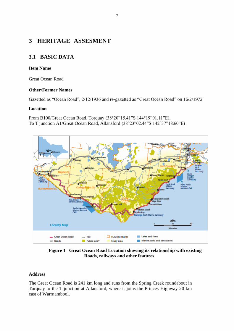
3 HERITAGE ASSESMENT
3.1 BASIC DATA
Item Name
Great Ocean Road
Other/Former Names
Gazetted as “Ocean Road”, 2/12/1936 and re-gazetted as “Great Ocean Road” on 16/2/1972
Location
From B100/Great Ocean Road, Torquay (38°20‟15.41”S 144°19‟01.11”E),
To T junction A1/Great Ocean Road, Allansford (38°23‟02.44”S 142°37‟18.60”E)
Figure 1 Great Ocean Road Location showing its relationship with existing
Roads, railways and other features
Address
The Great Ocean Road is 241 km long and runs from the Spring Creek roundabout in
Torquay to the T-junction at Allansford, where it joins the Princes Highway 20 km
east of Warrnambool.

8
Suburb/Nearest Town
The eastern end of the Great Ocean Road is at Torquay and the nearest town at the western end is Warrnambool
State
Victoria
Local Govt. Area
• Colac Otway Shire Council
2-6 Rae Street
Colac Vic
• Corangamite Shire Council
181 Manifold Street
Camperdown Vic
• Moyne Shire Council
Princes Street
Port Fairy Vic
• Surf Coast Shire Council
1 Merrijig Drive
Torquay Vic
• Warrnambool City Council 25 Liebig Street
Warrnambool Vic
Owner
On 2 October 1936 the Great Ocean Road Trust officially handed over control
of i t s s e c t i o n o f the Great Ocean Road to the Government of Victoria. The
road was proclaimed a Tourist Road on 2 December 1936 gazetted as “Ocean
Road” (it was re-gazetted as “Great Ocean Road” on 16 February 1972). Currently
VicRoads has control of the Great Ocean Road.
Current Use
Currently, The Great Ocean Road is used as an Arterial Tourist Route, which links the north-south roads that connect various coastal towns to the Princes Highway.
Former Use
The Great Ocean Road was used for many purposes as follows:
• To give assistance to settlers in getting produce to market
• To aid the development of timber resources
• Quick delivery of mails to sea-side towns and those a few kilometers inland

9
• Provide easy telephone communication.
• For taking supplies to Cape Otway Lighthouse.
Designer
Major William Thomas Bartholomew McCormack was the Honorary Engineer for
the Great Ocean Road Trust taking an interest in the work and made
engineering decisions. Most of the day to day organizing and design work was
done by the Chief Engineer of the CRB, A.E Callaway, and construction
engineers and surveyors including J.B. Wilkie, W. Pascoe, C. Jones and J. Hassett4.
Maker/Builder
The section of the road between Eastern View and Skenes Creek was surveyed by CRB surveyors, financed by the Great Ocean Road Trust and built by returned servicemen. The remainder was built either by the CRB or local shires, except for the section between Anglesea and Aireys Inlet, which was built by the owner of the land through which it passed, Mr C.J. Lane. Year Started
1919
Year Completed
1932 (part only)
Physical Description
The Great Ocean Road is a two lane winding bitumen structure which extends 241
kilometres on the south-west coast of Victoria and starts at Torquay near the B100
Surfcoast Highway and ends at Allansford near Warrnambool.
The majority of the road follows the often steep southern coastline with outstanding
scenic views which culminates in the eroding limestone of the Port Campbell
National Park exemplified by the Twelve Apostles.
Along the road there are frequent pull-overs at strategic view points where people
can stop to observe the various landscapes and amazing views adjacent to the
coast, with the 75 km extending from The Arch at Eastern View to Apollo Bay
being the most spectacular section of the road constructed along rocky cliffs,
including exposed rocky road cuts, which display evidence of being made by
hand5. The geology of the terrain that the road traverses consists of a
combination of sedimentary rocks, horizontally bedded sandstone that form steep
cliffs, Tertiary Limestone and conglomerates. The rapid erosion of the Southern
Ocean has formed steep and overhanging cliffs at Port Campbell National Park,
4 Alsop, Peter, 1982, A History of the Great Ocean Road, publ. Geelong Historical Society.p13
5 Douglas Stone, G. D. (1991). Explore The Great Ocean Road. Lilydale: Australia Guides Pty Ltd. P17

10
were iconic landforms have been formed, such as the Twelve Apostles and the
former London Bridge.
There is a wide variety of plants along the road, ranging from predominantly tall wet
eucalypt forest to coastal heathlands. Coastal headlands, woodlands, rain forests and
shrubby forests are seen along the road, close to Port Campbell National Park, with
dairy cattle grazing, plantations and coastal townships.
There are important memorials erected as key features along the road, with the
most important one being The Arch at Eastern View, which commemorates the
construction of the road. The road itself can be said to be the largest war memorial
in the world. The Eastern View Arch has a collection of plaques, a bronze sculpture
of road workers and modern landscaping. 6
Physical Condition
The Great Ocean Road has been subjected to continuous and ongoing maintenance
to keep the road in good condition. Improvements have included augmentation
of the road, numerous realignments and the replacement of timber bridges with
stronger concrete structures. There is little information on the condition of other
aspects of the historical fabric, including the hand-cut markings on the cliff faces
adjacent to the road, subterranean remains of the workers’ camps and the historical
markers including the arch at Eastern View.
Modifications and Dates
6 Faggeter, R. (2000). The Great Ocean Road: From where to where? Unpublished paper.
DATE YEAR EVENT MODIFICATION LENGTH
(Kilometres)
May 1918 The Great Ocean Road Trust had N/A N/A
been formed
July 1918 The Trust decided that the first section N/A
to be built would be between Lorne 30
and Cape Patton (between Wye River
and Apollo Bay)
5 1918 The Government approved the Board doing
August work on behalf of the Trust with survey N/A N/A
work to commence as soon as possible
July 1919 Mr.John Hasset surveyed the first section of N/A 40
the road as far as Eastern View
18 Mr.John Hasset had surveyed the second N/A 26
September section starting at Cape Patton
19 1919 Construction of the Great Ocean Road Begins N/A
September
18 1922 The first length between Lorne and Eastern View N/A 58
March was opened

11
Over the next decade the Trust continued work on the Great Ocean Road, linking
Lorne with Anglesea and Cape Patton.
During the period of its construction up until 1932, it has been estimated that more
than 3,000 former soldiers worked on the project.
26 1932 The completed road from the Lorne to Apollo
November Bay section was officially opened by the N/A 48
Lt. Governor, Sir William Irvine
By this date each traveller had to pay a toll but,
The control of the road
2 1936 the Premier of Victoria, Mr. A. A. Dunstan, passed to the Country N/A
October ceremoniously unlocked the toll-gate at Roads Board – marking
Shelley Beach at Eastern View the cessation of the toll
YEAR EVENT MODIFICATION LENGTH
(Kilometres)
1936-
1946
A great deal of work was done by the
Country Roads Board to improve the
alignment and width of the road
Not applicable Not applicable
1950-
1960
Not applicable Concrete bridges
replaced all the timber
bridges and the
floodways
Not applicable
1970 Not applicable The road was
completely
reconstructed and
realigned between
Glenaire and Laver’s
Hill
17
1971 There was a major landslip at Windy Hill -
about 3 km south west of Lorne (it was
estimated that the quantity of moving rock
exceeded 200,000 tonnes)
The road had top be
closed for five months
while remedial work
was carried out. 43
anchor cables were
installed. At the time, it
was the largest
landslide stabilised by
Not applicable

12
3.1.1 Historical Notes7
The Great Ocean Road traverses the traditional country of a number of Aboriginal people
including: the Wathaurung people of the Geelong area; the Gulidjan whose land extends from
the Gellibrand River to Colac and the lakes and wetlands beyond; the Gadubanud
(Katubanut) whose land extends east of the Gellibrand River and centres around the Otway
Ranges; the Girai Wurrung (Kirrae Wurrung), west of the Gellibrand River to Warrnambool;
and the Wada Wurrung (Watha Wurrung), north of Painkalac Creek. This area continues to
be of economic, spiritual and cultural importance to these Aboriginal communities. Evidence
of their occupation of the land can be seen in various middens of shellfish along the coast and
stone artefacts scatters.
The first European to come to the area was William Buckley who, in 1803, escaped from the
convict settlement at Sorrento and made his way over a number of years to the south west
coast of Victoria where he was sheltered by the local aborigines for 32 years.
A wave of exploration and settlement spread down the south-west coast of Victoria following
the founding of Melbourne in 1835 and the subsequent settlement of Geelong. These
settlements along the coast were serviced either by ships or by tracks going inland to what is
now the Princes Highway or later to railway stations. There was no connection between
these coastal settlements.
In 1859 an electric telegraph line from Melbourne was established, it ran to Geelong,
Winchelsea then out to the coast at Moggs Creek before following a coastal route to Cape
Otway. There it linked to the submarine cable to King Island and Tasmania. A bridle path
along the telegraph route was well used as a track between Lorne and Apollo Bay despite
being extremely challenging and dangerous.
7 This section was re-written by David Beauchamp in early 2013 to expand and clarify the earlier
section written by Carlos Negron.
cable anchoring in
Australia.
1984 The final sealing works took place between
Apollo Bay and the Calder River (near
Holden Vale)
Not applicable 5
1984 Construction work on the section between
Stones Corner and the Otway Lighthouse
Road began in late 1984.
This work will remove
the last remaining
unsealed section of the
Great Ocean Road
8
1987 The sealing of the road to Peterborough was
completed
Not applicable Not applicable
13
Towards the end of the 19th-century Loutit Bay (Lorne) and Apollo Bay became popular
holiday destinations. Spring Creek (Torquay), Swampy Creek (Anglesea) and Aireys Inlet
also started to become popular. Only Lorne and Apollo Bay could be reached by sea or by
coach and horseback along rough tracks from the railway stations at Deans Marsh or at
Forrest. Separate roads from Geelong led to Torquay and Anglesea. An inland track linked
Aireys Inlet to Anglesea. There was no coastal road connecting these holiday resorts. Early in
the 20th century agitation began for a coastal road to link Geelong to Aireys Inlet and Lorne.
When the Country Roads Board (CRB] was established in 1913 there were hopes that it
would build a coastal road but this was not to be as a the CRB's role when it was created was
to determine which roads should be main roads and to build and maintain these roads. In
1918 the Development Road Act was passed giving the CRB approval and money to build
development roads, these were roads to link farming communities to either rail heads or to
main roads. This act enabled the CRB to build a road from Deans Marsh to Lorne and from
the Forrest to Apollo Bay.
In 1916 the Hon. Donald MacKinnon MLA, the chairman of the State War Council asked
William Calder, the chairman of the CRB whether it would be able to employ returned ex-
servicemen, when the First World War ended. On 5 December 1916, the CRB suggested
eight roads that could be constructed by returned soldiers including the South Coast Road.
This road would start at Barwon Heads then follow the coast westerly through Torquay,
Anglesea, Aireys Inlet, Lorne, Apollo Bay, Cape Otway, Glen Aire (now Glenaire)8,
Princetown, Port Campbell and Peterborough finishing at Nirranda where it would connect to
the main road to Warrnambool. This road would link up along the coast the main roads
running down to the coast from the railway system: Geelong to Barwon Heads, Geelong to
Anglesea, Deans Marsh to Lorne, Forrest to Apollo Bay, Beech Forest to Apollo Bay, Lavers
Hill to Glenaire, Lavers Hill to Princetown, Cobden to Port Campbell and Princetown.
As this road was neither a main road nor a development road, it could not be financed by the
CRB. The mayor of Geelong (Councillor Howard Hitchcock) with other civic minded
citizens set up the Great Ocean Road Trust, which held its first meeting at Colac, on 22
March 1918. The purpose of the Trust was to raise £150,0009 to build the 100 miles (161
km) of road necessary to link the various development roads to give a coastal road from
Barwon Heads to Warrnambool, at total length of 172 miles (277 km). The road would be
entitled The Great Ocean Road and would be a ‘worthy Memorial to all Victorian Soldiers,
and a National Asset for Victoria'.
A brochure published by the Great Ocean Trust said that the ‘Whole of the Work is to be
offered to the physically fit returned soldiers suitable for that class of work. The Country
Roads Board of Victoria has kindly agreed to supervise the whole of the work without any
remuneration and the specifications for the road will be up to the usual standard of the CRB
and they will engage the Returned Soldiers through the Repatriation Board. The congenial
surroundings, such as sea bathing, fishing and shooting, should be very acceptable to the
physically fit and suitable Returned Soldiers.’ The brochure went on to say, ‘The carrying
out of this Scheme would provide the finest Ocean Road in the world. Travellers
throughout the world know nothing which would compare with it.’
8 Where spelling of place names has changed the original spelling is given once with the new spelling
in brackets and then the new spelling used for the rest of the paper. 9 Monetary amounts have not been converted to dollars as the present day value is hard to ascertain
14
Major W.T.B McCormack, member of the CRB Board, was honorary engineer to the Great
Ocean Road Trust. Although he took an interest in the work and made engineering decisions
much of the design work devolved on to the chief engineer of the CRB A.E. Callaway and
construction engineers and surveyors J.B. Wilkie, W. Pascoe, C. Jones and J. Hassett.
In May 1918 the Repatriation Department offered to supply the tents blankets and tools to the
returned soldiers offered jobs on the project. The Great Ocean Road Trust decided in July
1918 that the first section of road to be built would be an 18 mile (29 km) stretch between
Lorne to Cape Patten (Cape Patton). The Repatriation Department engaged five returned
soldiers to survey the route. Warrant Officer J. Hassett was in charge of the party consisting
of three chainmen and a cook. The survey started at Cape Patton and proceeded to Lorne. The
Argus reported on 17/9/1918 that the party had made 3 miles (4.8 km) of “investigation
survey" round the face of Cape Patton, and expected to reach Lorne at Christmas. They
reported that the first section presents more engineering difficulties than other sections on the
route, but they can all be overcome. By July 1919, Hassett had pegged out 24 miles (38.6 km)
to Eastern View. The survey finished on September 18, 1919 when it reached Anglesea a
distance of 36 miles (58 km) from Cape Patton.
The day after the completion of the survey the Trust organized a ceremony to mark the
official beginning of the construction work. The Premier, Mr. Lawson set off a series of
explosions at Lorne to mark the official launch of the road construction, although work had
already been proceeding for about a month. At a celebratory dinner that night at Erskine
house the Trust president Councillor Hitchcock asked the Premier to give the Trust some
blocks of land that it could sell if the government was not to provide any financial assistance.
A camp had been set up for 20 men 1 mile (1.6 km) from the St Georges River near Lorne.
Corporal G Cooper, ex 12th Field Engineers was appointed supervisor of the returned
soldiers. He had, prior to enlisting, been a foreman under the CRB and had experience of
road making in France while on active service. The ex-servicemen received 10 shillings and
sixpence for an 8-our day and worked a half-day on Saturdays each had a tent and there was a
dining marquee and kitchen at the camp.
A report in the News of the Week by Captain Chaplain Neville said that a vegetable garden
had been planted near the camp. The men had lunch brought to them by their cook and hot
meals are ready when they return from work.
In February 1919 the CRB announced its decision to construct some sections of the Ocean
Road, totaling 26 miles (41.6 km). They were Skenes Creek to Cape Patton, Torquay bridge
to Jan Juc (now Bellbrae), South Gellibrand to Princetown, Princetown to Port Campbell,
Apollo Bay towards Elliott River and the section near the Aire River.
In January 1920, surveyor Hassett reported that the work was in very bad shape. After his
advice, the camp was dismantled and the tools and equipment stored at Lorne. In March the
Trust decided that instead of building the road from Lorne to Apollo Bay it would instead
concentrate on building the road to link Lorne to Geelong.
In April 1920 Mr. W. J. Bridges was appointed overseer and a camp was set up at Reedy
Creek. Work then proceeded from this camp towards both Lorne and Eastern View. Most of
this work was arduous and required blasting to create the road. No mechanical equipment
was available and all the work was done by hand. The road was 15 foot wide (4.6 m) with the

15
passing spots every hundred yards (91.4 m), a 4 mile (6.4 km) section of the road cost £4,500.
In December 1920 the Great Ocean Road (Land Sales) Act was passed, 1180 acres (47.5
hectares) of Crown land was to be sold for 15 shillings per acre (0.4 hectares) to the Great
Ocean Road Trust, which would then apply the net proceeds of sale of 1 acre (0.4 hectares)
allotments towards the cost of constructing the Great Ocean Road. In April 1921 at an
auction, 26 blocks at Big Hill were sold realizing about £1,100.
By October the Trust had spent £13,416 on the road and had liabilities of £4,500. The
chairman Councillor Hitchcock said that while the Trust had started with the idea of funding
the road itself, this was now not possible and that there wasn't enough land left to pay for the
rest of the work, which was in danger of ceasing because of the Trust's cash crisis. A landslip
at Big Hill put a further drain on the Trust's funds as a cost £500 to clear. Shortly afterwards
the Trust put in place a barrier at Big Hill to prevent traffic to Lorne, as lack of funds
prevented the completion of the road and its maintenance.
On Saturday March 18, 1922 the Governor of Victoria, Lord Stradbroke, officially opened
the road between Eastern View and Lorne. At the opening ceremony at Grassy Creek Lord
Stradbroke said the Great Ocean Road would form a permanent link between Victoria and the
Great War, and was proof of patriotism to the memory of the gallant dead. Nearly 80 cars,
filled with tourists, followed in procession behind the Governor’s car over the new road to
Lorne. Alderman Hitchcock entertained 150 guests at a dinner at Erskine House. Heavy rain
overnight prevented many of the cars returning by the Great Ocean Road and they had to
return via Deans Marsh.
In May 1922 the road was closed for improvements, including blasting rock from dangerous
bends, changes to the grade etc. By the end of May more than 75 men were working on the
road. By August 94 men were working on road improvements and construction of the road
west of Lorne to Apollo Bay
In December the road was reopened but because funds raised by the Trust were not enough to
ensure that road construction continued tolls were introduced (they were to last for the next
14 years). The tollgate was at Grassy Creek
Mr. Lane, who owned the Sunnymead Estate, tried, without success, to get the Winchelsea
Shire Council, who opposed the Great Ocean Road, to construct the section of road between
Anglesea and Aireys Inlet. He ended up building this as a private road through his estate. It
went from the top of the hill at Anglesea to Boundary Road at Aireys Inlet, along the present
route of the Great Ocean Road. In December 1924, he opened this road (known as ‘Long
Beach Road’) to the public, adding another 5 miles (8 km) to the coastal highway. It bypassed
most of the previous bush track between Anglesea and Aireys Inlet. To recoup some of the
£4,000 he had spent making the road he installed tollgate on the road near Aireys Inlet. In
1927 the Trust purchased that section of the road for £1,870 and removed the tollgate.
The Argus 15/02/1923 reported that since Christmas more than 8,000 people had passed
through the toll-gate at Grassy Creek and tolls amounting to £250 had been collected.
Sixty returned soldiers started work in March 1923 on the section of road between Wye River
and Cape Patton cutting a 15 foot wide (4.6 m) track along the cliffs. Their continued
employment depended on what funds the Trust could raise.

16
In March the Trust subdivided, for sale, 264 acres (107 hectares) of land at Eastern View that
it had acquired, where it later built a hotel and golf links hoping to develop a tourist township
to rival Lorne.
The State Government in 1923 made £50,000available for the building of Tourist Roads,
which included the sections of the Great Ocean Road. The portion allocated to the Great
Ocean Road was used, together with £1,000 raised by the Trust, to set up a camp for 50
former soldiers at Cumberland River to work on the Lorne to Wye River section of the road.
In February 1924 a gang of 30 men started work on the Mt. Defiance section of the road. In
the same year, the steamer Casino was stranded near Cape Patton forcing it to jettison its
cargo of 500 barrels of beer and 120 cases of spirits. The ex-diggers salvaged the cargo,
which resulted in a two-week drinking binge.
The 1926 annual report of the CRB recorded that works in progress included 1.5 miles
(2.4km) of development road between Apollo Bay and Wye River to give access to the port
of Apollo Bay of a large area of land on the coast that was suitable for grazing and dairying.
In July 1927 the CRB report to Parliament on the Lorne to Apollo Bay section of the road
stated that the public had contributed £21,000 to the cost of the work which included 8 miles
(12.9 km) of sidecutting, and 17 miles (27.4 km) of track 5 feet (1.5 m) wide. A gang of ex-
soldiers was widening the grade track between Lorne and Wye River and £16,900 was
needed to complete the earthworks that would allow cars to travel the 108 miles (174 km)
between Melbourne and Apollo Bay via the Great Ocean Road.
The annual report of the CRB for 1929 stated that £3,265 was expended on the Mount
Defiance section of the road where work was still proceeding.
In February 1930 the road to Cumberland River opened. 64 men continued construction on
the Mt. Defiance section of the road. To help finance the work the Trust sold 11 cottages and
54 blocks of land at Wye River that it had acquired in 1928 from the Henry Jones Company
who had established a timber mill at Wye River in 1919 but closed it two years later because
it was unprofitable.
In February 1931 a new section of road between Aireys Inlet Lighthouse and Moggs Creek
opened making use of a new bridge constructed by the local residents. The new section of
road replaced the old inland route (the Old Coach Road) and shortened the distance between
Anglesea and Lorne by 3 miles (4.8 km).
At the 14th
annual meeting of the Trust it is announced that the road was complete between
Geelong and Warrnambool. The road still needed to be metalled and a projection cut away at
Mt Defiance.
On November 25, 1932 the official ceremony to open the road began, the vice-regal party
travelled from Geelong along the Great Ocean Road to Lorne and the next day to Apollo Bay
before returning to Lorne for the official opening ceremony.
In December a grant of £5,000 from the Government unemployment relief fund was used to
widen the road and provide work for more than 200 returned soldiers over the Christmas
17
period.
Towards the end of 1933 the Great Ocean Road between Lorne and Aireys Inlet was closed
to allow widening of the road from a single lane with passing bays to a two lane road. The
Trust borrowed £25,000 from the unemployment relief loan and applications scheme, which
enabled 400 men to be employed. The work entailed a considerable amount of blasting as
well as reconstruction, at higher levels of a number of bridges over creeks along the road. By
the end of March 1934 the work was completed giving a metalled road 16 feet (4.9 m) wide
from Geelong to Apollo Bay.
On April 4 1935 the Governor Lord Huntingfield and his wife Lady Huntingfield unveiled
two memorial tablets at Mt. Defiance. One to honour the founding chairman of the Great
Ocean Road Trust, Howard Hitchcock, who had died in 1932 three months prior to the
official opening of the road. The other stating that the Great Ocean Road had been built to
commemorate the services of the soldiers and sailors in the Great War 1914-1919.
Having completed the road and linking it to the section of the road constructed by the CRB
the Trust transferred the care and management of the road to the CRB. On Friday, October 2,
1936, Mr. C. R. Herschell, the honorary managing director of the now incorporated Great
Ocean Road Trust Pty Ltd, gave a key to the Premier, Mr. Dunstan who unlocked the tollgate
at Shelley Beach near Lorne thus abolishing the tolls and making the road a public highway.
On the same day the Governor opened the golf course at Eastern View by teeing off at the
first hole. The Trust’s debt of £25,000 was taken over by the CRB on the provision that over
the next three years the Trust would sell its assets and transfer the money to the Crown.
These assets included 28 building blocks at Wye River, an interest in the Wye River hotel, 18
acres (7.3 hectares) of land near the tollgate at Shelley Beach, 60 blocks of land at the Big
Hill estate, and at Eastern View a nine-hole golf course, a cottage and outbuildings on 120
acres (48.6 hectares), 43 half acre (02 hectares) blocks and 100 acres (4.5 hectares) of land.
The last action of the Trust was to erect, in 1939, an archway over the Great Ocean Road at
Eastern View in memory of Major W.T.B. McCormack the Trust’s Honorary Engineer, a past
Board Member and Chairman of the CRB.
From 1919 to 1936, the Great Ocean Road Trust constructed most of the section of the Great
Ocean Road between Eastern View and Cape Patton, a distance of 25 miles (40km) at a cost
of £85,000 from money subscribed by the public and from loans. Employment was given to
a total of 3,000 returned soldiers. The number employed, at any one time varied according to
the finance available. The section built by the Trust traversed very difficult terrain requiring,
at times, workers to be suspended from ropes to drill holes for explosive charges. The work
was largely done by pick and shovel; debris was removed by wheelbarrow or for the less
steep sections by horse drawn scoops. It was not until 1923 that a grader was used and a
truck donated by a Melbourne firm became available to spread metal on the road.
The exact extent of the Great Ocean Road constructed by the Trust is uncertain. The plaque
at Cape Patton states that the Trust section extended to that point but in CRB annual reports
mention is made that the CRB was building a development road from Apollo Bay to Wye
River. The 1930 report stated that the section of road being constructed by the Trust was
within a mile of being linked to the development road constructed by the CRB from Apollo
Bay to the Jamieson River and that $2,000 was needed to be spent to make the short
connection between Mount Defiance and the Jamieson River to complete the road between

18
Melbourne and Apollo Bay.
The remaining 200km of the Great Ocean Road consisted of sections of existing main roads
or was built as a development road and later tourist road by the CRB, except for 8 km
constructed as a private road by Mr. Lane between Anglesea and Aireys Inlet. All of the
larger bridges such as at Kennett River, Wye River and Curdies River Inlet were built from
local timber by the CRB.
Since the CRB, later renamed VicRoads took over the maintenance of the road it has had to
cope with floods causing massive rockslides and washouts, and bushfires. The 1950 CRB
annual report contains photos of the damage caused by a flood in October 1949. In February
1954, severe flooding followed by huge storms isolated Aireys Inlet, Eastern View and
Lorne. At Devils Elbow, near Eastern View tonnes of rock and soil fell on the road; at
Fairhaven, a culvert collapsed and at Hutt Gulley, a huge washout required bridging with a
temporary ‘Bailley’ bridge. A section of the road was washed away at Princetown in 1960.
The road was closed near Lorne in 1964 because of landslides. When, in May 1971, the CRB
became concerned that half a million tons of rock were poised, ready to fall, above Windy
Point, five miles (8 km) south of Lorne they closed the road between Lorne and Wye River
for five months. To stabilize the land above the road 55 rock anchors had to be installed.
The 1983 Ash Wednesday bushfire that swept along the coast from Lorne to Point
Roadknight destroyed a number of the timber bridges as well as the memorial arch at Eastern
View. On April 23, 1985, torrential rain and flooding cut the Great Ocean Road between
Lorne and Apollo Bay, cars and caravans were swept into sea at the Cumberland and Wye
Rivers. The flooding caused the road to drop five metres in some sections and bridge
approaches were washed away. In 1988, on a section of road 3 km south of Wye River,
progressive landslips were causing collapse of the roadway. To prevent further collapse a
retaining wall was built on the seaward side of the road using Terramesh gabion face
elements connected to woven steel mesh laid horizontally between layers of compacted fill
that supported the road surface.
Maintenance of the Great Ocean Road is an ongoing problem because of the steep nature of
the land that the road traverses. Much of the rock and clay strata slope towards the sea, when
water gets into the clay layers ‘greasy backs’ form, resulting in sections of the cliffs
collapsing onto the road or into the sea.
Since its completion the Great Ocean Road has been continuously improved by the CRB, the
Road Construction Authority and later VicRoads. It has been realigned, widened, sealed, the
pavement strengthened and timber bridges replaced with concrete bridges. As a result the
Great Ocean Road has become one of Victoria’s major tourist attractions. It remains a tribute
to the returned soldiers who built by hand the most difficult part of the road and a lasting
memorial to those who fought and died in the Great War.
In 2011 the Great Ocean Road was added to the Australian Heritage List

19
3.1.2 Comparable Roads to the Great Ocean Road
The Grande Corniche, France/Italy: The Grande Corniche in the south of France
runs along the coast from about Nice to Monaco and then on into Italy. This road is
at least as steep as the country through which the Great Ocean Road passes and has
iconic destinations such as Nice, Monte Carlo, San Remo and Genova on the
Italian side. This is the most romantic road in the world and displays stunning
views, ( as the Great Ocean Road does) a perfect symbol of French absolutism
combined with luxury and frivolity. A masterpiece designed by Paris's L'Ecole des
Ponts et Chaussées, the world's first civil engineering school; the Grande Corniche
was made to facilitate Napoleon’s ambitious Italian campaign of 1796.
There is no official boundary, but it is usually considered that the road extends
115 kilometres from the Italian border in the east to Saint Tropez, Hyères or Cassis
in the west.
The Grande Corniche, France

20
The Big Sur, California, USA: This road goes through country very reminiscent
of the Great Ocean Road country. It runs between San Francisco and Los
Angeles but the really iconic section is between Monterey and Morro Bay (about
200 km). It passes through the towns of Big Sur, a name derived from the original
Spanish-language "el sur grande", meaning "the big south", or from "el país grande
del sur", "the big country of the south". The terrain offers stunning views, making Big
Sur a popular tourist destination. Like the Great Ocean Road it is surfing country.
The Big Sur, California
21
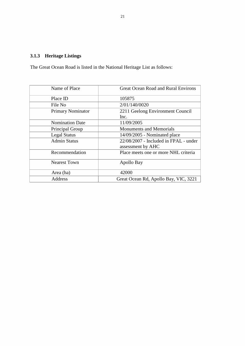
3.1.3 Heritage Listings
The Great Ocean Road is listed in the National Heritage List as follows:
Name of Place Great Ocean Road and Rural Environs
Place ID 105875
File No 2/01/140/0020
Primary Nominator 2211 Geelong Environment Council Inc.
Nomination Date 11/09/2005
Principal Group Monuments and Memorials
Legal Status 14/09/2005 - Nominated place
Admin Status 22/08/2007 - Included in FPAL - under assessment by AHC
Recommendation Place meets one or more NHL criteria
Nearest Town Apollo Bay
Area (ha) 42000
Address Great Ocean Rd, Apollo Bay, VIC, 3221

22
Other important structures along the Great Ocean Road have been listed as they
posses historical significance. The most relevant are:
Name of Place Listing
Authority
Location
Statement of Significance
The Great Ocean
Road Arch
Memorial
Heritage Inventory
(HI)
Great Ocean Road,
Eastern View, SURF
COAST SHIRE
Erected in 1939 and symbolizes the
sacrifice made by thousands of
returned soldiers during First World
War.
Apollo Bay War
Memorial
Heritage
Inventory
(HI)
Great Ocean Road
APOLLO BAY, Colac
Otway Shire
Erected in 1922 to commemorate the
local men and women who served
during the First World War. The
Apollo Bay War Memorial is of
historic importance to the Shire of
Colac Otway.
Wye River Memorial
Heritage Inventory
(HI)
Great Ocean Road WYE RIVER, Colac
Otway Shire
Erected in the late 1940s. Local
beach stones were used for the
construction of the memorial. The
Wye River War Memorial Cairn is
of social and historic importance to
the Shire of Colac Otway. It has
social and cultural associations with
World War One.

23
3.2 ASSESSMENT OF SIGNIFICANCE
3.2.1 Historical significance
The construction of the Great Ocean Road represents an outstanding and iconic
scenic coastal road which helps developing an understanding of parts of Australia’s
history. It is an important reminder of the participation and hard work of the
Victorian soldiers from World War I and how the community commemorated their
work and provided for their continuing welfare upon returning to Australia.
The Great Ocean Road planning structure enabled the integral approach and
collaboration of four local shires to protect and maintain the magnificent natural
scenery of the region. This impetus and creation of the Great Ocean Road led to an
evolution in the protection and preservation of land in Australia for its
environmental value.
The main design of the road was to follow the natural lines and contours of the
coastal land, which enhances the scenic views along the road and provides an
aesthetic and pleasing journey along the coast. The amazing views and diverse
scenery enhances international tourism and are highly valued by Australian
community, and have inspired artists, writers, musicians and many others to feel
involved for its aesthetical qualities.
The geomorphologic formations of the Twelve Apostles are widely recognized and
have made the site a popular tourist attraction and are capable of attracting many
tourists from around the world enhancing the local tourism and economy of
Australia.
3.2.2 Engineering significance
The Great Ocean Road was a newly-designed tourist route built on a winding
course following the natural topography on the west coast of Victoria. Conceived
by the Chair of the Country Roads Board, renowned Australian engineer and
surveyor William Calder and the honorary engineer was Major William
McCormack. The Great Ocean Road was Major McCormack’s greatest
achievement, and he is honored for his contribution through a memorial plaque
at Eastern View. Although McCormack oversaw the project, the majority of
the day to day supervision and design was undertaken by Arthur E. Callaway,
Chief Engineer of the Country Roads Board, with a team of construction engineers
and surveyors. 10
The project cost was approximately ₤150,000 and was primarily funded
through private donations and fundraising by the Great Ocean Road Trust, with
little financial assistance from the government. It took 13 years to survey and
complete, using a labour force of more than 3,000 returned servicemen who required
a “chit” (letter/note) from the Repatriation Department to be eligible for the work,
and in later years, depression sustenance workers.
10
Alsop, Peter, 1982, A History of the Great Ocean Road, publ. Geelong Historical Society
24
The works were undertaken with hand tools, explosives, wheelbarrows and horses dragging scoops. Men were lowered down the cliff by using ropes tied to trees to enable charges to be set. The servicemen were paid 10 shilling and sixpence per day, approximately equivalent to the average Australian wage in 1920. This was four shillings and sixpence more than their pay whilst in service. In the early years of the project the workers were not pleased with the conditions of their employment. Some did not find the climate agreeable; others disliked the rough camping conditions and were disappointed with the low salaries, which were sometimes delivered late. In February 1920 the works were suspended, and the men were blamed for poor quality workmanship and claimed to be inexperienced. Works recommenced in April 1920 and the slow progress continued. At that time, the track was too narrow for vehicles to pass, and the road was only formed, not metalled, and the heavy rain usually caused the cliffs to slip onto the road. By 1934 the road was metalled and before that, many considered it only a fair-weather track, with heavy rain making the route impassable. Periods of torrential rains caused a number of other rock slides and road closures in the latter half of the twentieth century.
From an engineering perspective, the section of the Great Ocean Road from
Lorne to Cape Patton is the most impressive from a road construction point of view,
as the road is benched into steep and precipitous cliffs of great magnitude. At
Windy Point (about three kilometres southwest of Lorne), the height of the
natural surface is over 200 m while the road surface is about 20 m above Bass
Strait. The rock comprises massive sandstone beds formed with clay beds, which
dip steeply towards the sea.
The geomorphology and the terrain of the Great Ocean Road require high levels of
road management and maintenance as heavy rainfalls have been the reason for
continuous rock sliding due to clay beds becoming slippery. There was a major landslip in
1971 which led to road closure for a period of five months while remedial works were
carried out. A number of alternatives were considered including relocating that stretch of
road inland adding a further 21 km to the distance to Apollo Bay. Another proposal was
to massively irrigate the slope to encourage all the unstable material to fail. This was to
be followed by the construction of a new road further to seaward using rock fill from the
slide. The third proposal – which was the adopted solution – was to install cable
anchors into the face of the slope drilled on a bearing directly counter to the direction
of movement. In all, 43 anchor cables were installed and tensioned to a force of 200
tonnes each prior to being permanently grouted. At the time, it was the largest landslide
stabilized by cable anchoring in Australia. 12
This work was described in a technical report
by Adrian Williams and Allan Muir entitled "The Stabilization of a Large Moving
Rock Slide with Cable-Anchors". A film was made which was subsequently used by
various universities to assist in lectures relating to cable anchor design.
After a week of continuous movement of up to 20 mm or more per day, one
huge, localized section of rocky hillside (in front of the old bridle track and
independent of the larger rock slide beneath) started moving more quickly
(independent of the rest of the hill), towards the roadway below.
Jellie, D. (2010). Great Ocean Road. Melbourne. Upublished Paper.
12

25
Experienced crews of workmen from Apollo Bay, Anglesea, and Lorne were called
to drill, blast and removed rocks (up to the size of a house) that blocked the
hillside and which would have prevented installation of the cable-anchors. This
was extremely hazardous and technically difficult work requiring the best and most
skilled people available. Once the site was made safe, a contract was awarded for
the installation of cable-anchors that were required to stabilize the remaining
hillside.
A total of 45 Cable-Anchors were installed, varying in length from 18m to 43m
with each consisting of either twelve or ten 15.2 mm diameter individual cables
(strands) having a grouted "anchorage end" at the base of the drill hole (6.7m
long) and with a reinforced concrete "anchorage block" at the top on which to
stress the cables. There were 12 anchors with 12 strands and 33 anchors with 10
strands.
The process of installing the cable-anchors was as follows:
• Holes were drilled using Ingersoll-Rand Air Track drilling rig equipment
suspended from a temporary system of cables and pulley blocks anchored at
the top of the hill.
• Cable-anchors were made up at road level, complete with plaited ends at
the "anchor end".
• Using an onsite mobile crane, the cable was lifted up to the hole and installed by sliding the cable down the hole into position.
• The section of cable at the anchorage end at the bottom of the drill hole was grouted.
• The reinforced concrete anchor block at the other end of the cable was
cast by first removing surface rubble down to hard durable rock and
installing grouted dowels (rock pins) into the rock surface on which the
concrete anchor block was to be cast.
• The reinforced concrete anchor block was then cast over the rock and dowels.
• The grout in the anchorage end and the concrete at the other end was cured for
28 days in order to gain the required strength.
• The cables were then stressed up using a small light hydraulic jack and
hand-operated hydraulic pump on each of the 10 strands that made up the
tendon. During stressing checks were made on force/extensions to confirm
that there was no movement or loss of force and to make sure that there was
no slippage at the anchor end.
• Lift off forces where checked at the stressing head after a week to ensure that the designed tendon anchorage load was holding.
• The full length of anchors were finally grouted and grout protection cappings cast over the stressing heads to prevent rusting of the cables and
anchor plates.
• 13 drainage holes of up to 53m in length and inclined at between 5 and 25
degrees to the horizontal were also drilled into the rocky hill side to
intercept the known fissures or water bearing areas and to minimize the
increase in hydrostatic pressure due to any heavy rain.
• Any remaining, localized, unstable rocks were fixed in position using rock
pins. The rock pins were 1.5 to 2.5 m long 25mm or 35mm deformed
galvanized steel reinforcing bars, grouted into holes drilled with a jack
26
hammer. This process was called "Rock Stitching".
The average load in each cable was around 200 tons. The grouted anchor covers
over the stressing heads and the reinforced concrete anchorage blocks can be
seen clearly from the roadway.
Accurate survey checks have continued since the cable anchors were installed,
and more recently, a "real time monitoring system" has been installed by
VicRoads which comprises a number of extensometers positioned across joints and
defects in the rock mass. The instruments are connected to a data logger and alarm
system that is capable of sending SMS messages and triggering a flashing light
located on site. This new warning system will establish real time monitoring
capabilities at the Windy Point site and facilitates the downloading of important data
at regular period.
The movement of the Windy Point landslide was arrested after the installation and
stressing of the first 7 cable anchors – but a further 38 cables were then installed
to provide the required designed factor of safety.”
In April 1985, extremely heavy rain also fell in the Otway Ranges. The downpour
fed rivers and gullies which cross the Great Ocean Road in a 22 mile stretch east of
Skenes Creek. The road was cut in four places due to erosion of the road and
bridge approaches. There were also numerous landslips and trees and rock debris
blocked the road. Culverts and bridges were jammed by debris but all survived
unscathed. However there were washouts at the approaches to some bridges. At
Sugarloaf Creek, between Skenes Creek and Kennett River, a gap of 15 m long
had been eroded at the bridge approach. Further east, at Orchard Creek, a
culvert was blocked by flood-borne debris and the overflowing water eroded
about 60 m of roadway. Temporary repairs were implemented immediately and the
road was able to be re-opened within three days – although some sections were
limited to one lane. However permanent repairs continued through until
September 1985.
The Great Ocean Road has also been closed as a result of bushfires, the most
notable of which was the Ash Wednesday fire that ravaged the area from Aireys Inlet
to Lorne in 1983. This fire destroyed 41,000 hectares, destroyed over 700 homes and
three people perished.
Similar to many road projects, the Great Ocean Road undergoes continuous
improvement and maintenance, including realignment, widening, pavement
strengthening, guard rail installation, passing turn outs, resealing, and improved
drainage. Since the opening of the road, tens of thousands of Australian citizens
have been involved in the design, construction and maintenance of the Great Ocean
Road either as employees or contractors of the Country Roads Board, the Road
Construction Authority and Vic Roads. It has been their contribution that has led to
the Great Ocean Road becoming a major tourist attraction in Victoria – and a lasting
legacy for the people involved in its creation.

27
3.2.3 Historic Individuals or Association
William Thomas Bartholomew McCormack (1879 – 1938) William Bartholomew
was born on the 1st of January1879 at Heathcoat, Victoria. He was one of the
founding members of the Country Roads Board of Victoria and was the Engineer in
charge of the design and construction of the Great Ocean Road.. See Appendix 4.
William Calder (1860–1928) Calder was the first Chief Engineer and Chairman of the
Country Roads Board and served in these positions until his death in 1928. He has
significant influence on the early days of the Great Ocean Road. The Calder Highway
is named after him. See Appendix 4.
Howard Hitchcock (1866 – 1932) Howard Hitchcock was born on 31 March 1866
at Geelong, Victoria. He was a businessman and Mayor of Geelong and became
chairman of the Great Ocean Road Trust by 1918, and it was his devotion, energy
and personal contributions that kept the project afloat. Hitchcock’s perspective of
creating a memorial drive resulted in a very important legacy for Australian
community.
Edna Margaret Walling (1895 – 1973) Born on 4 December 1895 at York, England
and was one of the most important and influential landscape designers in the 1920‟s.
She had vast experience in coastal views and particular interest in native
plants, which was the reason why the environment along the Great Ocean
Road was one of the main factors in her increasing advocacy.
In the construction of the Great Ocean Road, special consideration had to be
given to the returned soldiers who were particularly involved in the construction
from 1919 to 1932.
3.2.4 Creative or Technical Achievement
Technically, when the Great Ocean Road opened in 1932 it was regarded as a great
engineering achievement in early road building and surveying in Australia. The
work was undertaken with hand tools, explosives, wheelbarrows and horses
dragging scoops. Men were securely tied with ropes to trees as they were lowered
down the steep cliffs to enable them to set charges.
The Great Ocean Road was described as a handmade, newly designed tourist road,
constructed on a winding course along the south-west coast of Victoria. 11
11
Douglas Stone, G. D. (1991). Explore The Great Ocean Road. Lilydale: Australia Guides Pty Ltd. P32

28
3.2.5 Research Potential
Some remains of the construction camps have been found along the Great Ocean Road,
which have archeological potential for understanding the way the workers lived during the
construction period. The size of certain of the camps and their existence throughout
the 13 years of construction of the road creates the potential for unusually rich
deposits of archaeological material relating to sustenance workers over a span of time.
Archaeological investigation is likely to show evidence of the camps and may provide
insight into the working and living conditions of the road workers and those who
supported them in remote locations during the inter-war period.12
Along the Otway Coastal site of the Great Ocean Road, fossil records have been located
of a diverse range of dinosaurs, which has contributed to the human understanding of
a polar environment in the Cretaceous period. Paleontological research continues in the
Otway Ranges Coastal Cretaceous site, which may lead to further discoveries and revelations
in the future.
Scientific understanding of marine species and evolutions from the late Oligocene period
have been taken place by the recent fossils discovered near Bells Beach, showing
important information of Australia’s past due to the quick erosion of the Great Ocean Road
coastline.13
3.2.6 Social
Accessibility and development of local communities along the Great Ocean
Road as a consequence of the construction of the road:
Since the final section of the road was laid with bitumen in 1983, population along the coast
has increased substantially enlarging the towns and communities within the Region.
These communities have predominantly been located around the Princes Highway, the
Great Ocean Road or along the main north-south roads linking the two major arterials.
Although there are a number of alternatives to access the Great Ocean Road, the eastern
entry to the Great Ocean Road and its towns and major attractions, is generally from
Torquay.
Touring the Great Ocean Road is recognized as a highly valued visitor experience and
major visitation attractor. Tourism Victoria claims there are now 5 million visitors to the
region every year and figures are growing rapidly.
12 Department of Sustainability, E W (2010), Australian Heritage Database, Retrieved 17 December
2010. 13 Ibid.
29
Development of local industries in communities along the Great Ocean Road
other than tourism:
Signs directing tourists to the Great Ocean Road and its major features generally convey
the message to the traveler unsure of the road network that the Great Ocean Road must be
used to access towns and features along it. This common impression is supported by much
of the tourist information that is freely available.
The economic strength of the area has been traditionally built around primary production and
this is expected to continue to dominate the regional economy. Farm and business
investment in production, processing and agriculture in the region makes a major
contribution to the economy.
The Great Ocean Road Region, plus the dairy country around Warrnambool and Port
Fairy, produces two billion litres of milk a year in total, resulting in $4 billion worth of
processed milk product for the area (the Great Ocean Road Region’s share would be about
65–75 per cent of the total). In all, the dairy industry employs about 6,000 people.
Agricultural production at the farm gate alone is worth more than $400 million annually.14
Other local industries throughout the Great Ocean Road region include forestry and
fishing, which are also significant. Total employment in these sectors represents 40 per
cent of the region’s workforce. On a regional scale, these levels of production and
employment make a significant contribution to the economy. For the near future, rural
enterprises will continue to improve the regional economy. Significantly, a number of
these economic activities (milk and timber) have a major impact on the road infrastructure.
Tourist benefits of the Great Ocean Road for Australian and international visitors:
The Great Ocean Road tourist region has more visitors than any other tourist region in
Victoria, outside Melbourne. In the past years, the region which runs from Geelong
to the South Australian border attracted approximately 2.7 million overnight visitors and
5.4 million day-trip visitors. The growth in international tourism is a good indicator of the
increasing popularity of the region. Local government in the region estimates the annual
growth in visitor numbers to the region is 15 per cent. One of the nation’s largest coach
tour operators has identified the Great Ocean Road as the single most popular destination
for domestic and international visitors. Over the past five years, it has increased its tours
from two runs a week to a daily operation. The value of tourism in the Great Ocean Road
tourist region was estimated to be $940 million. Along the Great Ocean Road, the tourism
industry has now become a fundamental element of the economy of a number of
communities. During 1996, tourism in the towns and rural areas along the Great Ocean
Road provided 14.7 per cent of the total employment. For many other places in the region,
employment in tourism is a small but rapidly growing sector. Tourism, both domestic
14 Department of planning and Community Development. (2010, September 10)
Retrieved 15 December 2011, from Great Ocean Road Region Strategy:http//www.dpcd.vic.gov.au/planning/plansadpolicies/ coastal-planning-in-victoria/great-ocean-road-region-strategy

30
and international, is an important component of the economy and is likely to grow at a
faster rate than the anticipated growth rate for the rest of the economy.15
Other cultural activities facilitated by the Great Ocean Road:
Bells Beach is an internationally recognized surfing location which is strongly associated
with the development of the surf industry in Australia, and has considerable importance for
the large Australian surfing community. The Bells Beach Surfing Recreation Reserve,
declared in 1973, was the first of its kind in Australia and the first specifically proclaimed
surfing reserve in the world. The unique surfing conditions at Bells Beach, and the
international competitions held there, have been instrumental in the development of
surfing technology in Australia. In 1970 Bells Beach was the first Australian venue for
the World Surfing Titles and its Easter surfing tournament remains the world’s longest
running international surfing carnival featuring one of the two most prestigious surfing
trophies in the world. 16
3.2.7 Rarity
The Road is unusual and rare as it was built on a completely new alignment and did not follow any existing track or footpath. It was purpose-built as a scenic touring road, characterized by sea level crossings of rivers and inlets and elevated headlands. The historic and social inputs that created it make the road a unique Australian coastal road. 3.2.8. Representativeness
Several roads have been built such as the Grande Corniche between France and Italy,
which extends from Nice to Monaco, and the and The Big Sur in California between San
Francisco and Los Angeles but none of these are equal to the Great Ocean Road for
beautiful ocean, mountain, river, or fern gully scenery.
3.2.8 Integrity/Intactness
The Great Ocean Road has been subjected to continuous maintenance and is considered to
be in good condition, with a high degree of integrity. There is little information on the
condition of other aspects of the historical fabric, including the hand-cut markings on the
cliff faces adjacent to the road, subterranean remains of the workers camps and the historical
markers including the arch at Eastern View.
15 Infrastructure, D.o (2001). Great Ocean Road Region Discussion Paper. Geelong South 16 Infrastructure, D.o (2001). Great Ocean Road Region Discussion Paper. Geelong South

31
4 STATEMENT OF SIGNIFICANCE
The Great Ocean Road is significant for its historic, scenic and social values. It was
constructed between 1919 and 1932 and marks a significant stage in the development of road
construction in Australia. Historically, it represents a significant reminder of the Victorian
servicemen from the First World War and the Australian community’s appreciation for
their service. The road was predominantly constructed by hand and very little machinery
was used, which enhances the historical and social value.
Some of the most important features that illustrate the evidence of its importance as a
memorial road include the physical infrastructure that extends from Torquay to Allansford,
including the latest upgrades of the road through the Otway Ranges and the eastern
headland of Port Campbell; the Memorial Arch at Eastern View and the various plaques
at Eastern View and Mount Defiance; finally evidence of handmade marks of
construction along the cliff faces adjacent to the road.
Recreational tourism was one of the main purposes of the road’s construction, and the
cultural and natural tourism experiences it offers, including the iconic Twelve Apostles and
“Shipwreck Coast‟, are greatly valued by the Australian community.
The iconic Bells Beach is valued by Australia’s surfing community for its place in
Australian surfing. It was the world’s first Surfing Recreation Reserve, and remains the
location of the world’s longest running international surfing carnival and home to one the
most prestigious trophies in surfing.19
The construction of the Great Ocean Road has been valued by international tourists and
local communities for its powerful and diverse scenic views along the coastal road,
including the geological rock formation of the Twelve Apostles and the amazing colors of
the Ocean displayed at Bells Beach. The Great Ocean Road has been one of the most
important tourist sites that aim to show an important phase in Australian tourism.
4.1 Area of Significance
State and National
Department of Sustainability, E.W (2010). Australian Heritage Database. Retrieved
December 17, 2011. From Australian Heritage Database:
http//www.environment.gov.au/cgi-bin/ahdb/search.pl?mode=
Place_detail;place_id=105875
19

32
5 INTERPRETATION PLAN
5.1 Interpretation Strategy
The strategy for interpretation of the Engineering Heritage Works is laid out in the latest
version of EHA’s “Guide to the Engineering Heritage Recognition Program” 17
. The
interpretation will be by marking the works with an appropriate level of heritage marker; a
public ceremony to unveil that marker and an interpretation panel which summaries the
heritage and significant features of the works for the public.
This plan provides a summary of the proposals for design, content, location, manufacture and
funding of the proposed interpretation.
5.2 Date for the Event
The ceremony should be held on Sunday 1 September 2013 at 10 am.
5.3 The Interpretation Panel:
The following will be incorporated into the design of the panel:
1) A title: “The Finest Ocean Road in the World”.
2) A subtitle: “Building the Road - Hands, Horses, and Horsepower”.
3) Logos of Engineers Australia and VicRoads and Citywide.
4) A small scale representation of the EHA marker plate.
5) The date and other details of the marking ceremony.
6) A web site reference to the availability of the full nomination on the EHA web page.
7) A QR code to the above reference.
8) Text for main text panels should be 30 point Arial Bold.
9) Minimum text size should be 24 point Arial Bold.
10) A map will be required on this panel, particularly to show the stages of development
of the road.
7) Historic photographs will be used to illustrate the panel. Many historic photographs
exist. Brief captions for each photograph and source references to be used with each
photograph.
The interpretation panel will technically be constructed and erected as follows:
1) Size to be nominally 1200 mm wide by 600 mm high.
2) The panel to be constructed of vitreous enamel-on-steel plate with flanges as per
drawing at Appendix 2.
17
The 2012 version. It should be noted that this version is not available on the Engineers Australia at
the time of writing.

33
3) The panel to be mounted on a steel free-standing frame as per Appendix 2.
4) The EHA marker (Engineering Heritage Marker/ Engineering Heritage National
Marker) to be mounted below the interpretation panel as shown in Appendix 2.
The location of the interpretation panel has not yet been agreed with the VicRoads, owner of
the land on which it is to be erected however it is likely to be placed in the parking area at the
Eastern View Arch. The location will be checked for safety of the public viewing it.
The marker will be mounted on the crossbar of the interpretation panel stand and measures
will be taken to secure it against removal by vandals by the installation of a “nut guard”.
5.4 Design Process for the Panel Content
The nomination will be reviewed during its development by the following parties:
1) The 10 members of the committee of Engineering Heritage Victoria
2) Mary Parker of VicRoads.
The design of the interpretation panel will be developed to the initial concept stage as part of
the nomination writing process. It will then be further developed to a draft panel status by
Richard Venus followed by review by the above reviewers plus the Heritage Recognition
Committee.
Manufacture will then be carried out by Glass Metal Industries, subject to availability of
sufficient funding with the fall-back position being manufacture using vinyl film on
aluminium by Advanced Group, Melbourne.
5.5 Funding
Funding for the interpretation panel is expected to be required as follows:
Item Fund Source Amount
Graphic Design including purchase of
photographic rights
EHA National Budget $500
Manufacture of panel by Glass Metal Industries
Citywide $1400
Manufacture of Steel Stand Citywide $1000
Installation of panel stand and panel Citywide $500
Supply from stock of marker by EHA EHA National Budget $200
TOTAL $3600
34
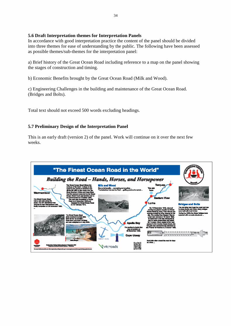
5.6 Draft Interpretation themes for Interpretation Panels
In accordance with good interpretation practice the content of the panel should be divided
into three themes for ease of understanding by the public. The following have been assessed
as possible themes/sub-themes for the interpretation panel:
a) Brief history of the Great Ocean Road including reference to a map on the panel showing
the stages of construction and timing.
b) Economic Benefits brought by the Great Ocean Road (Milk and Wood).
c) Engineering Challenges in the building and maintenance of the Great Ocean Road.
(Bridges and Bolts).
Total text should not exceed 500 words excluding headings.
5.7 Preliminary Design of the Interpretation Panel
This is an early draft (version 2) of the panel. Work will continue on it over the next few
weeks.
35
6 REFERENCES
• Anderson, W. K. (1994). Roads for the people: a history of Victoria's
roads. South Melbourne: VicRoads.
• Authority, R. C. (1984). Great Ocean Road, A brief History. Kew: RCA.
• Department of Planning and Community Development. (2010, September
10). Retrieved December 15, 2011, from Great Ocean
Road Region Strategy:
http://www.dpcd.vic.gov.au/planning/plansandpolicies/coastal-planning-in-
victoria/great-ocean-road-region-strategy
• Department of Sustainability, E. W. (2010). Australian Heritage
Database. Retrieved December 17, 2011, from Australian
Heritage Database: http:// www.environment.gov.au/cgi-
bin/ahdb/search.pl?mode=place_detail ;place_id=105875
• Department of Sustainability, Environment, Water, Population and
Communities. (n.d.). Australian Heritage Database. Retrieved
December 17, 2011, from http:// www.environment.gov.au/cgi-
bin/ahdb/search.pl?mode=place_detail;place_id =105875
• Douglas Stone, G. D. (1991). Explore The Great Ocean Road. Lilydale:
See Australia Guides Pty Ltd.
• F.B.Alsop, P. (1982). A History of the Great Ocean Road. Geelong:
Geelong Historical Society.
• Faggeter, R. (2000). The Great Ocean Road: From where to where? Unpublished Paper.
• Hyett, R. (1997). Great Ocean Road A Traveler's Guide. Port Campbell:
Great Ocean Publications.
• Infrastructure, D. o. (2001). Great Ocean Road Region Discussion
Paper. Geelong South.
• Jellie, D. (2010). Great Ocean Road. Melbourne. Unpublished paper.
• Wikipedia. (n.d.). Great Ocean Road. Retrieved December 2,
2011, from http://www.en.wikipedia.org/wiki/Great_Ocean_Road

36
6 APPENDIX 1 IMAGES
IMAGE 1: Locality map of The Great Ocean Road
Source: http://www.environment.gov.au/heritage/laws/publicdocuments/pubs/105875_5.pdf IMAGE 2: Great Ocean Road Arch at Easter IMAGE 3: Great Ocean Road Arch at
View: Picture Taken in the Early Eastern View. Picture taken
1950’s in 2011.
Source: Great Ocean Road Authority, 1984 Source: Carlos Negron, 2011

37
IMAGE 4: Land
Slip Repair Work
on the Great
Ocean Road on 1952.
Source: F.B. Alsop, 1982
IMAGE 5:
Work in Progress
on the Lorne-
Apollo Bay
Section.
Picture Shows
Diggers working
along the Great
Ocean Picture
taken Friday 19th
September 1919.
Source: F.B. Alsop, 1982
IMAGE 6:
Rock Cliffs along
the Great Ocean
Road.
Source: Owen Peake, 2009
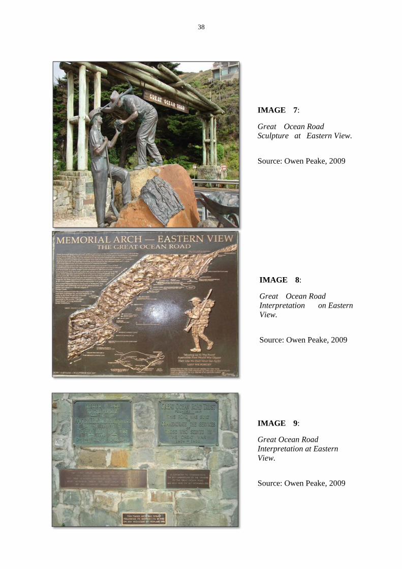
38
IMAGE 7:
Great Ocean Road Sculpture at Eastern View.
SSource: Owen Peake, 2009
IMAGE 8:
Great Ocean Road
Interpretation on Eastern
View.
SSource: Owen Peake, 2009
IMAGE 9:
Great Ocean Road
Interpretation at Eastern
View.
SSource: Owen Peake, 2009

39
IMAGE 10:
Great Ocean
Road
Interpretation at
Eastern View.
Source: Owen
Peake, 2009
IMAGE 11:
Great Ocean
Road
Interpretation at
Easter View
Source: Owen Peake,
2009
IMAGE 12: The
Great Ocean Road, The Twelve Apostles
SSource: Owen Peake, 2009

40
IMAGE 13:
The Road to
Lorne
completed.
Picture taken 18 March, 1922.
Source: F.B. Alsop, 1982
IMAGE 14: Former map of Great Ocean Road
Source: Great Ocean Road Authority, 1984

41
IMAGE 15: The
members of the
Great Ocean Road
Trust.
Photographed
outside the City
Hall. Geelong in
1918
Source: F.B. Alsop, 1982
IMAGE 16:
Inspection of the
Great Ocean
Road. On Big Hill,
Apollo Bay.
Picture taken on
July 1921.
Source: Great
Ocean Road
Authority, 1984
IMAGE 17:
Lord Stradbroke
cutting the
ribbon at the
official opening of
The Great Ocean
Road. Grassy
Creek. 18/3/1921.
Source: Great
Ocean Road

42
Authority, 1984
IMAGE 18: The Great Ocean Road. Mt. Defiance, Victoria. Photo taken in the early
1920’s
Source: The Road Series Postcards, 1920

43
APPENDIX 2 INTERPRETATION PANEL DRAWINGS The following drawings refer to earlier projects however their content is appropriate to this project. On the first drawing the panel for this project should be Type A i.e. vitreous enamel-on-steel. The second drawing is generic. The third drawing is adapted to placement in soft river soils. The legs may need to be shortened to adapt to the Eastern View site depending on the excavation conditions in the mounting holes.

44
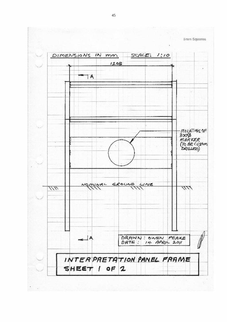
45

46

47
APPENDIX 3 OWNERS LETTER OF APPROVAL

48
APPENDIX 4 HISTORIC INDIVIDUALS OR ASSOCIATIONS
4.1 McCormack, William Thomas Bartholomew (1879–1938) 18
William Thomas Bartholomew McCormack (1879-1938), civil engineer and public servant,
was born on 1 January 1879 at Heathcote, Victoria, son of Thomas McCormack, Irish-born
publican and his wife Emily, née Ewen, of Sydney. Educated at the local state school and
privately, he worked as a clerk in the shire office at Seymour before being appointed in 1902
secretary and shire engineer at Mirboo, Gippsland. On 27 September 1904 at Mirboo
Catholic Church, he married Margaret Muirhead. Certificated as municipal surveyor,
hydraulic engineer and municipal clerk (Victoria) and engineer (New South Wales), he
worked as shire engineer at Lockhart, New South Wales, and Korumburra, Victoria, before
being appointed in 1909 to the Public Works Department as assistant engineer, engaged in
constructing roads and levees and reclaiming swamps. He was an honorary lecturer in
engineering at the University of Melbourne in 1913-15, a foundation member of the
Institution of Engineers, Australia, and a member of the Institution of Civil Engineers,
London.
In March 1913 McCormack was appointed one of the three foundation members of the
Country Roads Board of Victoria. In 1913-15 they travelled widely, frequently on horseback,
to lay the foundation of the State's road network. McCormack's knowledge of local
government, his diplomatic skills and quiet, equable personality made him a successful
ambassador for the board in its negotiations with sometimes fractious shire councils.
A lieutenant in the Australian Intelligence Corps in 1911-14, McCormack enlisted in the
Australian Imperial Force in January 1916 and in June embarked as major commanding the
10th Field Company, Engineers. In 1917 he acted as commanding royal engineer, 3rd
Division, under his mentor Major General (Sir) John Monash. Following the battle of
Messines he was mentioned in dispatches and in August 1918 was awarded the French Croix
de Guerre.19
After the war he briefly studied British road construction, town planning,
sewerage and water-supply.
Returning to Australia in April 1919 McCormack resumed his work with the Country Roads
Board, taking charge of the construction, initially by returned soldiers, of the Great Ocean
Road which reached Eastern View in 1922 and, eventually, Apollo Bay in 1932. 20
Acting
chairman of the board during William Calder's visit to Europe and the United States of
America in 1924, he was appointed chairman upon Calder's death in March 1928. During his
decade in office about 11,000 miles (17,703 km) of roadway were under his jurisdiction and
in that time much of its macadam surface, suitable for horse-drawn vehicles, was replaced
with more durable bitumen and gravel. He also established the board's research laboratory. In
18 Diane Langmore, This article was published in hardcopy in Australian Dictionary of Biography, Volume 10, (MUP), 1986, National Centre of Biography, Australian National University,
http://adb.anu.edu.au/biography/mccormack-william-thomas-bartholomew-7321/text12701 , accessed 19 August 2013.
19
He ended World War I with the rank of Major. 20
In addition to the above information he was appointed Honorary Engineer to the Great Ocean Road
Trust.

49
1937 McCormack visited North America to study advances in road-building and published a
report on his return.
Contemporaries observed that McCormack spoke of roads with poetic eloquence,
insisting that they should 'follow the lines of Nature' for aesthetic as well as practical
reasons. He was committed to providing 'a road to every farmer's gate' and urged the use of
local materials wherever possible.
A pianist and composer of dance music, McCormack was also a member of Victoria Golf
Club and donor of the McCormack cup to the Melbourne division of the Institution of
Engineers. He died in Melbourne from pneumonia on 23 January 1938 and was buried with
Catholic rites in Brighton cemetery. His wife, daughter and two sons survived him.
Memorials to him include an archway at Eastern View, opened by General Sir Harry Chauvel
in 1939.
Select Bibliography
• Institute of Engineers Journal, 11, no 12, Dec 1939
• Australian Road Research, Sept 1963
• Herald (Melbourne), 27 Feb 1913, 15 Mar 1928, 24 Jan 1938, 2 Nov 1939
• Age (Melbourne), 3, 24 Jan 1938
• Argus (Melbourne), 24 Jan 1938
• private information.
4.2 Calder, William (1860–1928) 21
William Calder (1860-1928), engineer, was born on 31 July 1860 at his father's sheep-farm at
Lovell's Flat, Milton near Dunedin, New Zealand, only son of Arthur Calder and his wife
Margaret Milne, née Strachan. Calder was educated at the local school at Milton and the
Otago Boys' High School in Dunedin in 1876-77. From 1881 he attended engineering
lectures at Otago University before entering the New Zealand Government Survey
Department as a cadet in October 1883; after five years practical training he passed the
authorized surveyors' examination with credit in July 1888.
Later that year Calder came to Victoria and worked in private engineering and surveying
firms. In October 1889 he became assistant town surveyor for the City of Footscray, and in
July 1890 town engineer. At night he studied to gain certificates as municipal engineer (1890)
and engineer of water-supply (1892). From December 1897 to March 1913, Calder was city
engineer and building surveyor to the City of Prahran. Among his achievements were
construction of, allegedly, the first asphalted carpet-road surface and the first refuse
destructor in Australia, and the completion of a major drainage project.
By 1912 the appalling condition of Victoria's rural roads was a major concern to both farmers
and motorists. That year a Country Roads Board was set up and Calder was appointed
21 Roger J. Southern, 'Calder, William (1860–1928)', Australian Dictionary of Biography, National
Centre of Biography, Australian National University, http://adb.anu.edu.au/biography/calder-william-
5466/text9287 , accessed 25 August 2013. This article was first published in hardcopy in Australian Dictionary of Biography, Volume 7, (MUP), 1979.

50
chairman, with W T B McCormack and F W Fricke as the other members. In its first two
years, the board travelled ceaselessly, inspecting a road system neglected by indigent
municipalities since the building of the railways. A meticulous note-taker and enthusiastic
photographer, Calder recorded the board's progress; his notes were transcribed and used as a
basic reference for many years. Maps were published in 1914 and 1915 showing the roads
selected for improvement. The board was endlessly tactful in receiving interest groups
pressing for various improvements, while insisting on high standards of construction and
financial control.
After 1918 there were shortages of money and manpower for road-building. Calder
campaigned publicly and privately for more funds, especially for arterial roads, and
invariably attained rapport with a succession of ministers. In 1924 he toured Europe and
North America; his report, published that year, is widely regarded as a classic of road-
construction practice and road-administration. In it he evaluated the contemporary
controversy over the use of cement concrete (the American model) and bituminous pavement
(the British); he favoured the latter for Australian conditions. Other recommendations
included experiments with new materials and a fuel tax to replace the vehicle tax.
Maintenance was to be given high priority, and he also stressed the importance of regulation
of motor transport to preserve road surfaces and to raise revenue.
Many of Calder's recommendations were included in the important Highways and Vehicles
Act of 1924, which provided for the declaration of State highways, two-thirds financed by the
State government through the C.R.B. This network of highways is perhaps Calder's main
achievement: the road to Bendigo and Mildura was named after him. The board's
organization was copied in other States, New Zealand and Fiji. He long advocated Federal
assistance in highway construction, and attended the first meeting of the Federal Aid Roads
Board set up under the Act of 1926.
Calder had married Elizabeth Bagley Palmer of Dunedin on 4 November 1889 at Brunswick.
He was a devout Presbyterian and member of his church boards of management of Footscray
and Armadale. He retained a pleasant but definite Scots burr all his life. Small, with a pointed
beard and a 'puckish sense of humour', he was a conscientious and methodical worker, of
conservative disposition and unchallenged integrity. He encouraged young engineers with
initiative and had close links with Professor Henry Payne of the University of Melbourne. A
'champion shot', he assisted with military training in the Moorooduc area during World War
I. Calder had hoped to retire to his small property at Red Hill, but died of cancer at East
Malvern on 18 February 1928. Survived by his wife, a son and a daughter, he was buried in
Cheltenham cemetery after a ceremony at Gardiner Presbyterian Church. Calder's wife was
saved from financial difficulty by a special State pension.
Memorials to him include an avenue of trees on the road to Geelong beginning one mile past
Werribee, cairns at Warragul and elsewhere in Gippsland, and a bridge at Moe. A Tom
Roberts portrait hangs in the C.R.B. board room, Kew.
Select Bibliography
R. Southern, ‘William Calder — public servant and engineer …’, Victorian
Historical Journal, 48 (1977), no 3, and for bibliography.

51
CHANGE CONTROL
VERSION 1 DECEMBER 2011 Carlos Negron
VERSION 2 JANUARY 2012 Carlos Negron
VERSION 3 FEBRUARY 2012 Carlos Negron
VERSION 4 FEBRUARY 2012 Carlos Negron
VERSION 5 14 MAY 2012 Carlos Negron
VERSION 5A 17 MAY 2012 Editing by Owen Peake
VERSION 5B 17 MAY 2012 Modification of sections covering the French Corniche roads (pages 14 and 24) by OP
VERSION 6 24 June 2012 Modifications by DB
VERSION 7 26 June 2012 Minor editing by OP
VERSION 8 28 June 2012 Minor editing by OP VERSION 9 6 March 2013 Reformatted and added DB new section on Historical Notes VERSION 10 2 May 2013 Formatting and addition of Interpretation Plan VERSION 11 16 May 2013 12,292 words Further Formatting VERSION 12 17 May 2013 12,292 words Added Appendix 2 VERSION 13 4 Jun 2013 11, 931 words Added Appendix 3 and modified clause 5.7 VERSION 14 25 August 2013 13, 498 words Added Appendix 4, added unveiling statement on page 5.