the hot springs at thermopolis, wyoming
TRANSCRIPT

The Hot Springs at Thermopolis, WyomingAuthor(s): N. H. DartonSource: The Journal of Geology, Vol. 14, No. 3 (Apr. - May, 1906), pp. 194-200Published by: The University of Chicago PressStable URL: http://www.jstor.org/stable/30055838 .
Accessed: 17/05/2014 04:04
Your use of the JSTOR archive indicates your acceptance of the Terms & Conditions of Use, available at .http://www.jstor.org/page/info/about/policies/terms.jsp
.JSTOR is a not-for-profit service that helps scholars, researchers, and students discover, use, and build upon a wide range ofcontent in a trusted digital archive. We use information technology and tools to increase productivity and facilitate new formsof scholarship. For more information about JSTOR, please contact [email protected].
.
The University of Chicago Press is collaborating with JSTOR to digitize, preserve and extend access to TheJournal of Geology.
http://www.jstor.org
This content downloaded from 193.105.154.144 on Sat, 17 May 2014 04:04:49 AMAll use subject to JSTOR Terms and Conditions
THE HOT SPRINGS AT THERMOPOLIS, WYOMING1
N. H. DARTON
At the southern end of the Bighorn Basin there is a great hot spring which presents some notable geologic features and an inter- esting question as to the source of the hot water. The spring is at the town of Thermopolis, a village and health resort which owes its existence largely to the reputed therapeutic value of the water. The locality is on the bank of Bighorn River, a few miles north of a high range which may be regarded as the southwestern continua- tion of the Bighorn Mountains. There are several springs, but one of them has by far the greatest volume. They issue from the red beds, here brought to the surface by a prominent local anti- cline. The present springs and their predecessors-for the region has been one of thermal activity for many centuries-have built extensive terraces of travertine or hot spring deposits similar to some of those in the Yellowstone National Park.
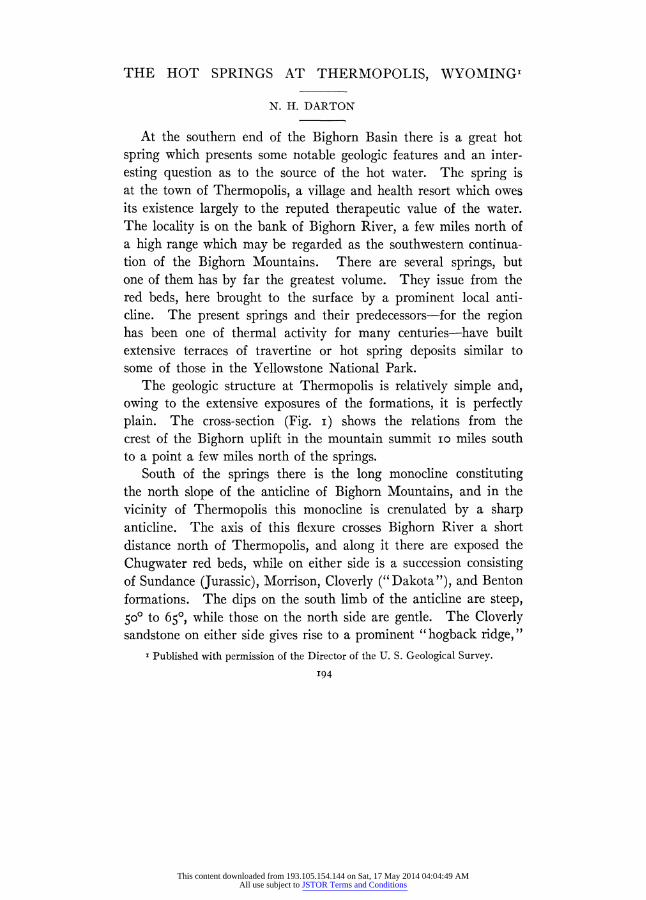
The geologic structure at Thermopolis is relatively simple and, owing to the extensive exposures of the formations, it is perfectly plain. The cross-section (Fig. i) shows the relations from the crest of the Bighorn uplift in the mountain summit io miles south to a point a few miles north of the springs.
South of the springs there is the long monocline constituting the north slope of the anticline of Bighorn Mountains, and in the
vicinity of Thermopolis this monocline is crenulated by a sharp anticline. The axis of this flexure crosses Bighorn River a short distance north of Thermopolis, and along it there are exposed the
Chugwater red beds, while on either side is a succession consisting of Sundance (Jurassic), Morrison, Cloverly ("Dakota"), and Benton formations. The dips on the south limb of the anticline are steep, 50' to 650, while those on the north side are gentle. The Cloverly sandstone on either side gives rise to a prominent "hogback ridge,"
1 Published with permission of the Director of the U. S. Geological Survey.
194
This content downloaded from 193.105.154.144 on Sat, 17 May 2014 04:04:49 AMAll use subject to JSTOR Terms and Conditions
HOT SPRINGS AT THERMOPOLIS, WYOMING 195
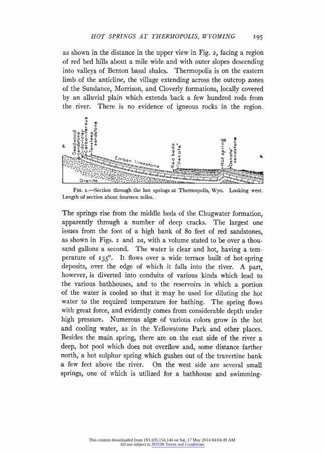
as shown in the distance in the upper view in Fig. 2, facing a region of red bed hills about a mile wide and with outer slopes descending into valleys of Benton basal shales. Thermopolis is on the eastern limb of the anticline, the village extending across the outcrop zones of the Sundance, Morrison, and Cloverly formations, locally covered by an alluvial plain which extends back a few hundred rods from the river. There is no evidence of igneous rocks in the region.
FIG. I.-Section through the hot springs at Thermopolis, Wyo. Looking west. Length of section about fourteen miles.
The springs rise from the middle beds of the Chugwater formation, apparently through a number of deep cracks. The largest one issues from the foot of a high bank of 8o feet of red sandstones, as shown in Figs. 2 and 2a, with a volume stated to be over a thou- sand gallons a second. The water is clear and hot, having a tem- perature of 1350. It flows over a wide terrace built of hot-spring deposits, over the edge of which it falls into the river. A part, however, is diverted into conduits of various kinds which lead to the various bathhouses, and to the reservoirs in which a portion of the water is cooled so that it may be used for diluting the hot water to the required temperature for bathing. The spring flows with great force, and evidently comes from considerable depth under high pressure. Numerous algae of various colors grow in the hot and cooling water, as in the Yellowstone Park and other places. Besides the main spring, there are on the east side of the river a deep, hot pool which does not overflow and, some distance farther north, a hot sulphur spring which gushes out of the travertine bank a few feet above the river. On the west side are several small springs, one of which is utilized for a bathhouse and swimming-
This content downloaded from 193.105.154.144 on Sat, 17 May 2014 04:04:49 AMAll use subject to JSTOR Terms and Conditions
196 N. H. DARTON
pool. An analysis of the water from the great spring, by Professor E. E. Slosson is as follows:
ANALYSIS OF WATER FROM HOT SPRINGS AT THERMOPOLIS, WYO. Grains per
Gallon
SiO2 . . . . . . . . . . 4.986 Fe203 and Al203 . . . . . . . 0.227 KCl . . . . . . . . . . . 10.249 Na2SO4 . . . . . . . . . . 15.110
Mg2SO4 . . . . . . . . . . 19.443 CaSO4 . . . . . . . . . . 3.156 CaCO3 . . . . . . . . . . 40.454 NaCl . . . . . . . . . . 26.195
Total . . . . . . . . 129.820
Hot Spring deposits.-The hot-spring deposits in the vicinity of
Thermopolis indicate a long period of accumulation, for they occur on several distinct terraces, some of which date back probably to
Tertiary time. The most recent deposits are being laid down on a broad terrace about 30 feet above the river, which is being built
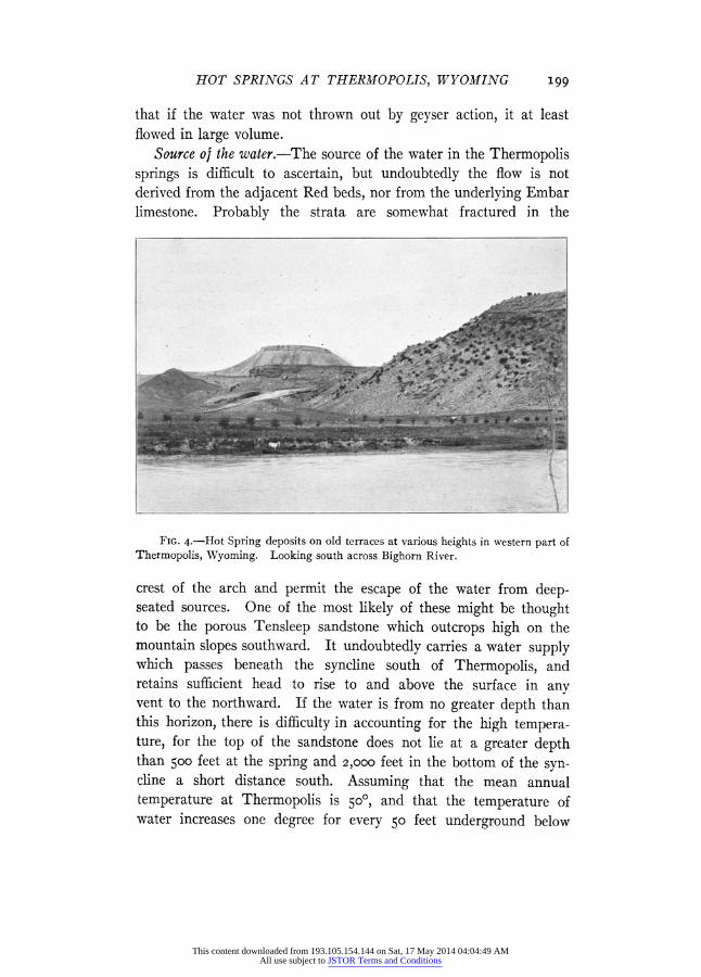
up very gradually. No precise estimate has been made of the rate of increase, but objects placed in the water are rapidly coated with the deposit, and a thickness of an eighth of an inch is accumulated in a short time. There are wide areas of the deposit on both sides of the river below the present springs, which were formed at no distant date, while, on the buttes which rise above this terrace level, there are caps of hot-spring deposits at various elevations. Some of the relations of these are shown in Figs. 3 and 4. The highest deposit caps a prominent butte near the cemetery, at an altitude of about 700 feet above the river. A larger terrace remnant remains on a butte which rises immediately west of the river to a height of about 350 feet above the water. It is probable that these terraces
represent three distinct stages of deposition, and, although possibly
hot-spring action has been continuous since the formation of the
first or highest terrace, most of the deposits at intermediate levels
have been removed. As travertine is often deposited on slopes, it
is possible that the hot-spring waters issuing at the level of the
higher buttes flowed to somewhat lower levels, with a continuous
This content downloaded from 193.105.154.144 on Sat, 17 May 2014 04:04:49 AMAll use subject to JSTOR Terms and Conditions
HOT SPRINGS AT THERMOPOLIS, WYOMING 197
deposit from one to the other. It is evident, however, from the relations that there has been extensive erosion since the earliest
period marked by the higher terraces on which the travertine caps are now found. The high butte near the cemetery-the one shown to the left in Figs. 3 and 4-is probably the remnant of a much
FIG. 2.-Travertine terrace of the Great Hot Spring on the east bank of Bighorn River near Thermopolis, Wyo. The spring is under the S. In the foreground are extinct hot-spring craters and a low ridge with long fissure in its summit. Shows upturned red beds and overlying formations.
more extended sheet of the travertine which was largely removed
prior to or during the development of the lower terraces. It is evident, from the disposition of the material, that the springs
have shifted their position, but in general the outflow has been in the immediate vicinity of the crest of the anticline. The hot-spring deposits show remnants of numerous hot-spring craters and cracks, some of the most marked of which are on the terraces near the river. On the west bank, a short distance north of the bathhouse, there is an empty crater 30 feet in diameter, shown in Fig. 2, indicating the former existence of a large hot pool, and there is another similar
This content downloaded from 193.105.154.144 on Sat, 17 May 2014 04:04:49 AMAll use subject to JSTOR Terms and Conditions
198 N. H. DARTON
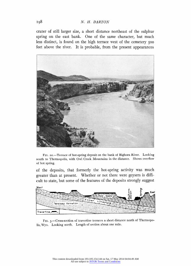
crater of still larger size, a short distance northeast of the sulphur spring on the east bank. One of the same character, but much less distinct, is found on the high terrace west of the cemetery 500 feet above the river. It is probable, from the present appearances
FIG. 2a.-Terrace of hot-spring deposit on the bank of Bighorn River. Looking south to Thermopolis, with Owl Creek Mountains in the distance. Shows overflow of hot spring.
of the deposits, that formerly the hot-spring activity was much
greater than at present. Whether or not there were geysers is diffi-
cult to state, but some of the features of the deposits strongly suggest
FIG. 3.-Cross-section of travertine terraces a short distance north of Thermopo-
lis, Wyo. Looking north. Length of section about one mile.
This content downloaded from 193.105.154.144 on Sat, 17 May 2014 04:04:49 AMAll use subject to JSTOR Terms and Conditions
HOT SPRINGS AT THERMOPOLIS, WYOMING 199
that if the water was not thrown out by geyser action, it at least flowed in large volume.
Source oj the water.-The source of the water in the Thermopolis springs is difficult to ascertain, but undoubtedly the flow is not derived from the adjacent Red beds, nor from the underlying Embar limestone. Probably the strata are somewhat fractured in the
FIG. 4.-Hot Spring deposits on old terraces at various heights in western part of Thermopolis, Wyoming. Looking south across Bighorn River.
crest of the arch and permit the escape of the water from deep- seated sources. One of the most likely of these might be thought to be the porous Tensleep sandstone which outcrops high on the mountain slopes southward. It undoubtedly carries a water supply which passes beneath the syncline south of Thermopolis, and retains sufficient head to rise to and above the surface in any vent to the northward. If the water is from no greater depth than this horizon, there is difficulty in accounting for the high tempera- ture, for the top of the sandstone does not lie at a greater depth than 5oo00 feet at the spring and 2,000 feet in the bottom of the syn- cline a short distance south. Assuming that the mean annual temperature at Thermopolis is 5o00, and that the temperature of water increases one degree for every 50 feet underground below
This content downloaded from 193.105.154.144 on Sat, 17 May 2014 04:04:49 AMAll use subject to JSTOR Terms and Conditions

200 N. H. DARTON
the first 50 feet-where the mean annual temperature is the under-
ground temperature-a depth of 4,300 feet would be required for the spring water to become heated to 1350 under ordinary condi- tions. As the granite probably lies only 2,500 feet below the spring, or 4,000 feet below the surface in the syncline south, this rate of increase would indicate a source at least as low as the base of the Deadwood formation. If the water is derived from the basal sandstone of that formation, it passes underground in the outcrop area in the high mountain slopes to the southeast, and becomes heated in the bottom of the syncline a short distance south of Ther-
mopolis. In order to preserve this heat in its course to the outlets, there must exist cavernous channels affording rapid flow, as heat
would be lost in slow percolation through the interstices of the rock.
It is possible also that the source of the water is much less deep, and
the heat may be due to deep-seated igneous rocks in this vicinity, which have not yet cooled. As the nearest outcrops of igneous rocks
are in the Shoshone Mountains 40 miles west, it appears improbable that there are any intrusions under the Thermopolis region.
This content downloaded from 193.105.154.144 on Sat, 17 May 2014 04:04:49 AMAll use subject to JSTOR Terms and Conditions