the hydrometeor classification algorithm for the
TRANSCRIPT

The Hydrometeor Classification Algorithm for the Polarimetric WSR-88D:Description and Application to an MCS
HYANGSUK PARK
Department of Astronomy and Atmospheric Sciences, Kyungpook National University, Daegu, South Korea
A. V. RYZHKOV
Cooperative Institute for Mesoscale Meteorological Studies, University of Oklahoma, and NOAA/OAR
National Severe Storms Laboratory, Norman, Oklahoma
D. S. ZRNIC
National Severe Storms Laboratory, Norman, Oklahoma
KYUNG-EAK KIM
Department of Astronomy and Atmospheric Sciences, Kyungpook National University, Daegu, South Korea
(Manuscript received 25 August 2008, in final form 24 November 2008)
ABSTRACT
This paper contains a description of the most recent version of the hydrometeor classification algorithm for
polarimetric Weather Surveillance Radar-1988 Doppler (WSR-88D). This version contains several modifi-
cations and refinements of the previous echo classification algorithm based on the principles of fuzzy logic.
These modifications include the estimation of confidence factors that characterize the possible impacts of all
error sources on radar measurements, the assignment of the matrix of weights that characterizes the clas-
sification power of each variable with respect to every class of radar echo, and the implementation of a class
designation system based on the distance from the radar and the parameters of the melting layer that are
determined as functions of azimuth with polarimetric radar measurements. These additions provide con-
siderable flexibility and improve the discrimination between liquid and frozen hydrometeors. The new
classification scheme utilizes all available polarimetric variables and discerns 10 different classes of radar
echoes. Furthermore, a methodology for the new fuzzy logic classification scheme is discussed and the results
are illustrated using polarimetric radar data collected with the Norman, Oklahoma (KOUN), WSR-88D
prototype radar during a mesoscale convective system event on 13 May 2005.
1. Introduction
Dual-polarization radar is a unique instrument for the
classification of radar echoes. Having dual-polarization
capability is essential for discriminating between meteo-
rological and nonmeteorological scatterers and for dis-
tinguishing between different hydrometeor types, such
as rain, hail, graupel, and snow of different habits. Fur-
thermore, knowledge of the hydrometeor type within
the radar resolution volume is required for choosing an
appropriate polarimetric rain rate relation to accurately
quantify the amount of precipitation (Giangrande and
Ryzhkov 2008).
Principles of fuzzy logic form the basis for most po-
larimetric classification algorithms; these were first ex-
plored by Straka and Zrni�c (1993) and Straka (1996)
and have since been further refined into more sophis-
ticated classification routines described by Zrni�c and
Ryzhkov (1999), Vivekanandan et al. (1999), Liu and
Chandrasekar (2000), Zrni�c et al. (2001), Schuur et al.
(2003), Keenan (2003), Lim et al. (2005), and Marzano
et al. (2008), among others.
The hydrometeor classification capability of a polari-
metric prototype of the Weather Surveillance Radar-1988
Corresponding author address: Alexander V. Ryzhkov, CIMMS/
NSSL, 120 David Boren Dr., Norman, OK 73072.
E-mail: [email protected]
730 W E A T H E R A N D F O R E C A S T I N G VOLUME 24
DOI: 10.1175/2008WAF2222205.1
� 2009 American Meteorological Society
Dow
nloaded from http://journals.am
etsoc.org/waf/article-pdf/24/3/730/4645673/2008w
af2222205_1.pdf by guest on 10 August 2020

Doppler (WSR-88D) in an operational environment was
tested in Oklahoma in 2002–03 during a demonstration
project called the Joint Polarization Experiment (JPOLE;
Ryzhkov et al. 2005b). Such a capability, together with
other polarization products, was very well received by the
National Weather Service (NWS) forecasters during this
operational demonstration (Scharfenberg et al. 2005).
One of the first versions of the National Severe Storms
Laboratory (NSSL) hydrometeor classification algorithm
(HCA) demonstrated a remarkable level of skill in de-
tecting hail, which was verified during the JPOLE cam-
paign (Heinselman and Ryzhkov 2006). Nonetheless, fur-
ther validation studies revealed several problems with
early versions of HCA that had to be addressed. These
problems are also inherent in other classification routines
that are utilized elsewhere.
First, it was found that the quality of the classification
depends on the quality of the polarimetric radar mea-
surements. It became evident that radar estimates with
enhanced measurement errors should be given lower
weight in the classification scheme. Second, due to an-
tenna beam broadening at longer distances, the radar
resolution volume may contain liquid, frozen, and mixed-
phase particles, and hence certain rules for class desig-
nation should be formulated based on the size of the
sampling volume as well as on the height and depth of
the melting layer. Finally, discrimination between con-
vective and stratiform precipitation types is necessary to
facilitate better distinction between dry–wet graupel
and dry–wet snow for which the polarimetric variables
overlap and hence may not be well separated.
Since JPOLE, the NSSL HCA scheme was modified
by incorporating additional routines that account for
possible errors in radar measurements, beam broaden-
ing, the relative location of the radar sampling volume
with respect to the melting layer (ML), and the nature
of the precipitation (i.e., convective versus stratiform).
The objectives of this paper are to describe the most
recent version of the HCA, which was recommended
by the U.S. National Weather Service for initial de-
ployment on the network of polarimetrically upgraded
WSR-88Ds, and to illustrate its performance in the case
of a mesoscale convective system (MCS) observed in
central Oklahoma on 13 May 2005.
The content of the paper is as follows. After the in-
troduction, the general structure of the algorithm is
described in section 2 where the classes of radar echoes
are also listed and the details of the aggregate computa-
tion are given. Section 3 introduces the confidence vector,
which depends on the statistical and physical parame-
ters affecting the measurements. Constraints on the
allowed classes are imposed using the distance from the
radar, beamwidth, and parameters of the melting layer
as discussed in section 4. The case study is presented in
section 5, which is followed by a summary and conclu-
sions in section 6.
2. General structure of the algorithm
a. Echo classes and radar variables
The HCA discriminates between 10 classes of radar
echo: 1) ground clutter, including that due to anomalous
propagation (GC/AP); 2) biological scatterers (BS); 3)
dry aggregated snow (DS); 4) wet snow (WS); 5) crystals
of various orientations (CR); 6) graupel (GR); 7) ‘‘big
drops’’ (BD); 8) light and moderate rain (RA); 9)
heavy rain (HR); and 10) a mixture of rain and hail
(RH). The big-drops category designates rain with a
drop size distribution skewed toward large raindrops.
This usually implies the presence of drops bigger than
3 mm and the deficit of smaller drops. Big drop signa-
tures are generally due to size sorting associated with
either convective updrafts often exemplified with ZDR
columns (Wakimoto and Bringi 1988) or wind shear and
veering, which cause ZDR ‘‘arcs’’ (Kumjian and Ryzhkov
2008). Both signatures have important prognostic value
because the ZDR columns are common in the initial stages
of convective development (Bringi and Chandrasekar
2001) and ZDR arcs characterize storm-relative helicity
in supercell storms (Kumjian and Ryzhkov 2008). The
class of biological scatterers includes insects, birds, and
bats. Other nonmeteorological scatterers in the atmos-
phere such as tornadic debris or military chaff may fall in
the category of either GC/AP or BS.
Six radar variables are directly utilized for discrimi-
nation. These are 1) the radar reflectivity factor at
horizontal polarization Z, 2) the differential reflectivity
ZDR, 3) the cross-correlation coefficient rhv between
horizontally and vertically polarized radar returns,
4) the specific differential phase KDP, 5) a texture pa-
rameter SD(Z) of the Z field, and 6) a texture param-
eter SD(FDP) of the field of differential phase FDP. The
parameters SD(Z) and SD(FDP) characterize the mag-
nitude of the small-scale fluctuations of Z and FDP
along the radial. The estimate of SD(Z) is obtained by
averaging Z data along the radial using a 1-km running-
average window (i.e., four data points spaced 0.25 km
apart are averaged), subtracting the smoothed esti-
mates of Z from the original values, and calculating the
root-mean-square (RMS) value of the residuals. Here,
SD(FDP) is calculated in a similar manner, but because
FDP has inherently large fluctuations, a 2-km running
average is utilized. In addition to the polarimetric var-
iables, the mean Doppler velocity V is utilized for dis-
crimination between hail and GC/AP, although it is not
JUNE 2009 P A R K E T A L . 731
Dow
nloaded from http://journals.am
etsoc.org/waf/article-pdf/24/3/730/4645673/2008w
af2222205_1.pdf by guest on 10 August 2020

included in the set of input variables for the fuzzy logic
classifier.
Due to the parameter range of KDP it is more con-
venient to use its values in logarithmic scale rather than
in linear scale. Hence, instead of KDP in degrees per
kilometer, we introduce the parameter LKdp, which is
determined as follows:
LKdp 5 10log(KDP) if KDP . 10�3 8 km�1
LKdp 5�30 if KDP # 10�3 8 km�1.
(1)
Before applying the classification procedure, Z, ZDR,
and rhv are smoothed along each radial using a 1-km
averaging window for Z and a 2-km window for ZDR
and rhv. In addition, a signal-to-noise ratio (SNR) at
horizontal polarization and a ratio of noise powers in
the two orthogonal channels are used for noise correc-
tion of ZDR and rhv (Schuur et al. 2003). Two smoothed
radial profiles of FDP are obtained by editing and using
two averaging windows corresponding to nine consec-
utive samples in the case of ‘‘lightly filtering’’ (2-km
window width if the sample spacing is 0.25 km) and
25 successive samples for ‘‘heavily filtering’’ (6-km
window width). Both Z and ZDR are corrected for at-
tenuation in precipitation using heavily filtered FDP by
adding the estimated biases
DZatt(dB) 5 0.04FDP(8) and
DZattDR(dB) 5 0.004FDP(8)
(2)
to the measured values of Z and ZDR (Ryzhkov and
Zrni�c 1995).
Finally, two estimates of KDP are obtained from a
slope of a least squares fit of the filtered FDP using two
range intervals corresponding to 9 and 25 consecutive
range gates. A lightly filtered KDP is used for classifi-
cation if Z . 40 dBZ and a heavily filtered KDP is se-
lected otherwise (Ryzhkov and Zrni�c 1996).
b. Computation of aggregation values
The classification scheme presented here combines
the information content of the polarimetric variables.
This is done by assigning a typical range of values for the
various polarimetric variables to each class of radar
echo. Each range of values is quantified with a mem-
bership (weighting) function. Membership functions are
summed, or multiplied, or otherwise combined for each
class in a process called aggregation. The aggregated
value of a class characterizes the likelihood that this
particular class is associated with the values of variables
measured by the radar. An aggregation value Ai for the
ith class of radar echoes is defined here as
Ai 5
�6
j51Wij Qj P(i)(Vj)
�6
j51Wij Qj
, (3)
where P(i)(Vj) is a membership function (which char-
acterizes the distribution of the jth variable for the ith
class), Wij is a weight between 0 and 1 assigned to the
ith class and the jth variable, and Qj is an element of
the confidence vector assigned to the jth variable. The
classification decision is based on the maximal aggre-
gation value.
Note that in the HCA we use an additive aggregation
routine that implies a summation of inputs from dif-
ferent variables with certain weights. Other investiga-
tors have used multiplication or the combination of
addition and multiplication (e.g., Liu and Chandrasekar
2000; Lim et al. 2005). Early versions of the HCA (Zrni�c
et al. 2001; Schuur et al. 2003) employed ‘‘hybrid’’ ag-
gregation schemes in which the membership functions
of ZDR and KDP were constructed as products of P(i)(Z)
and conditional functions PZ
(i)(ZDR) and PZ
(i)(KDP), re-
spectively. Our experience shows that the hybrid
schemes are too vulnerable to the Z biases caused by
miscalibration and/or attenuation and therefore the choice
was made in favor of a simple additive aggregation
procedure.
The membership functions P(i)(Vj) are assumed to
have trapezoidal shape with a maximal value of 1 and a
minimal value of 0 (Fig. 1). The trapezoidal functions
are described by four parameters: x1, x2, x3, and x4.
These parameters are presented in Table 1 for each
of the 60 membership functions. Trapezoids adequately
approximate the symmetric shapes of the probability
distributions of radar variables as well as the asymmetric
[such as cross-correlation coefficient rhv; Zrni�c et al. (2006)];
FIG. 1. Trapezoidal membership function, where X is an arbitrary
polarimetric variable.
732 W E A T H E R A N D F O R E C A S T I N G VOLUME 24
Dow
nloaded from http://journals.am
etsoc.org/waf/article-pdf/24/3/730/4645673/2008w
af2222205_1.pdf by guest on 10 August 2020

this is not true for some other popular membership func-
tions like Gaussian or beta (e.g., Liu and Chandrasekar
2000; Lim et al. 2005), which are symmetric.
Parameters x1–x4 of the membership functions of
ZDR and LKdp depend on radar reflectivity for all four
categories of rain (BD, RA, HR, and RH). The de-
pendency is chosen to describe a nonrectangular region
in the Z, ZDR space where the typical pair of these
values resides for each of the four rain categories
(similar to Fig. 2a in Straka et al. 2000). Thus, functions
f1–f3 and g1–g2 determine the x1–x4 in Table 1 and are
given by
f1(Z) 5�0.50 1 2.50 3 10�3Z 1 7.50 3 10�4Z2,
f2(Z) 5 0.68� 4.81 3 10�2Z 1 2.92 3 10�3Z2, (4)
f3(Z) 5 1.42 1 6.67 3 10�2Z 1 4.85 3 10�4Z2,
and
g1(Z) 5�44.0 1 0.8 Z and
g2(Z) 5�22.0 1 0.5 Z, (5)
where the radar reflectivity Z is expressed in dBZ.
The matrix of weights W in (3) characterizes the dis-
criminating efficiency of each variable with respect to
a particular class. The elements of the matrix W are
presented in Table 2. As an example, rhv is the most
important variable for the identification of biological
scatterers (W23 5 1.0) followed by the texture parame-
ters of Z and FDP (W25 5 W26 5 0.8), ZDR (W22 5 0.6),
and LKdp, which does not have any diagnostic value for
biological scatterers (W24 5 0). As in Lim et al. (2005),
the matrix W is determined subjectively and its further
refinement based on objective criteria will be made in
future studies. One possible criterion to accomplish this
refinement is the methodology described by Park et al.
(2007). This methodology takes into account the degree
of overlap between the probability density functions of
TABLE 1. Parameters of the membership functions for 10 classes. Reflectivity-dependent parameters f1–f3 and g1–g2 are defined by Eqs.
(4) and (5), respectively.
GC/AP BS DS WS CR GR BD RA HR RH
P[Z(dBZ)]
x1 15 5 5 25 0 25 20 5 40 45
x2 20 10 10 30 5 35 25 10 45 50
x3 70 20 35 40 20 50 45 45 55 75
x4 80 30 40 50 25 55 50 50 60 80
P[ZDR(dB)]
x1 24 0 20.3 0.5 0.1 20.3 f2–0.3 f1–0.3 f1–0.3 20.3
x2 22 2 0.0 1.0 0.4 0.0 f2 f1 f1 0.0
x3 1 10 0.3 2.0 3.0 f1 f3 f2 f2 f1
x4 2 12 0.6 3.0 3.3 f1 1 0.3 f3 1 1.0 f2 1 0.5 f2 1 0.5 f1 1 0.5
P(rhv)
x1 0.5 0.3 0.95 0.88 0.95 0.90 0.92 0.95 0.92 0.85
x2 0.6 0.5 0.98 0.92 0.98 0.97 0.95 0.97 0.95 0.90
x3 0.9 0.8 1.00 0.95 1.00 1.00 1.00 1.00 1.00 1.00
x4 0.95 0.83 1.01 0.985 1.01 1.01 1.01 1.01 1.01 1.01
P(LKdp)
x1 230 230 230 230 25 230 g1–1 g1–1 g1–1 210
x2 225 225 225 225 0 225 g1 g1 g1 24
x3 10 10 10 10 10 10 g2 g2 g2 g1
x4 20 10 20 20 15 20 g2 1 1 g2 1 1 g2 1 1 g1 1 1
P[SD(Z)(dB)]
x1 2 1 0 0 0 0 0 0 0 0
x2 4 2 0.5 0.5 0.5 0.5 0.5 0.5 0.5 0.5
x3 10 4 3 3 3 3 3 3 3 3
x4 15 7 6 6 6 6 6 6 6 6
P[SD(FDP)(8)]
x1 30 8 0 0 0 0 0 0 0 0
x2 40 10 1 1 1 1 1 1 1 1
x3 50 40 15 15 15 15 15 15 15 15
x4 60 60 30 30 30 30 30 30 30 30
JUNE 2009 P A R K E T A L . 733
Dow
nloaded from http://journals.am
etsoc.org/waf/article-pdf/24/3/730/4645673/2008w
af2222205_1.pdf by guest on 10 August 2020

each radar variable for different classes of radar echo.
More overlapping usually means lower values of weight.
3. Confidence vector
The quality of the radar echo classification is signifi-
cantly affected by the accuracy of the radar measure-
ments, which can be biased and noisy. The impact of the
measurements errors is accounted for in the aggregation
rule (3) via a confidence vector Q. In other words, for
each range gate, the jth radar variable is supplemented
with its confidence index Qj depending on its vulnera-
bility to several factors that can compromise the quality
of its measurement. These factors include 1) radar mis-
calibration, 2) attenuation, 3) nonuniform beam filling
(NBF), 4) partial beam blockage (PBB), 5) the magni-
tude of rhv (which determines the statistical errors of
all polarimetric variables), and 6) receiver noise. If the
quality of a certain radar variable is compromised in a
particular area of the radar echo, then it would be given
a lower weight in the classifier. The confidence vector is
defined as
Q 5 (Q1, Q2, Q3, Q4, Q5, Q6)
5 (QZ, QZDR, Qrhv, QKDP, QSDZ, QSDF), (6)
where the components Q1–Q6 are constructed (for con-
venience) as products of Gaussian functions that charac-
terize the impact of different factors on the measurement
errors. For example, a confidence index for the differ-
ential reflectivity QZDR is defined as a product of five
multipliers,
QZDR 5 FattFnbfFrhvFsnrFpbb, (7)
associated with five known sources of measurement
errors in ZDR: differential attenuation (Fatt), nonuni-
form beam filling (Fnbf), the value of rhv (Frhv), the
signal-to-noise ratio (Fsnr), and partial beam blockage
(Fpbb) (Bringi and Chandrasekar 2001; Ryzhkov 2007;
Giangrande and Ryzhkov 2005).
The factor Fatt is a Gaussian function of the measured
differential phase FDP, which is proportional to differ-
ential attenuation according to (2):
Fatt 5 exp �0.69FDP
F(Z)DP
" #28<:
9=;. (8)
Although ZDR is corrected for differential attenuation
using (2), the accuracy of such a correction inevitably
degrades with increasing FDP because of the uncer-
tainty in the coefficient of the proportionality between
DZattDR and FDP in (2) due to drop size distribution
variations and the possible presence of melting hail
(Ryzhkov et al. 2007). The right side of Eq. (8) is de-
fined in such a way that the factor Fatt decreases twice
once FDP reaches a threshold value FDP(Z). The threshold
FDP(Z) is an adaptable parameter in the HCA, which is
currently set to 2508.
Similarly, the factor Fnbf is defined as
Fnbf 5 exp �0.69DZDR
DZ(t)DR
" #28<:
9=;, (9)
where DZDR is a ZDR bias due to the vertical and hor-
izontal gradients of Z and ZDR within the radar reso-
lution volume (Ryzhkov 2007):
DZDR 5 0.02 V2 dZ
du
dZDR
du1
dZ
dudZDR
du
� �. (10)
Here, DZDR(t) is an adaptable threshold (currently 0.5 dB),
and V is a one-way 3-dB antenna pattern width (u and
u are the elevation and azimuth pointing angles of the
antenna). It is evident from (10) that the gradients of
Z and ZDR should be computed prior to the estimation
of DZDR.
In full analogy, the formulas for Frhv, Fsnr, and Fpbb can
be written as
Frhv 5 exp �0.691� rhv
Dr(1)hv
" #28<:
9=;, (11)
Fsnr 5 exp �0.69snr(Zdr)
snr
� �2( ), and (12)
Fpbb 5 exp �0.69a
50
� �2� �
. (13)
In (11)–(13), Drhv(1) 5 0.2 and snr(Zdr) 5 100.05 are thresh-
olds for rhv and the signal-to-noise ratio (snr; in linear
TABLE 2. Matrix of weights.
Class
Variable
Z ZDR rhv LKdp SD(Z) SD(VDP)
GC/AP 0.2 0.4 1.0 0.0 0.6 0.8
BS 0.4 0.6 1.0 0.0 0.8 0.8
DS 1.0 0.8 0.6 0.0 0.2 0.2
WS 0.6 0.8 1.0 0.0 0.2 0.2
CR 1.0 0.6 0.4 0.5 0.2 0.2
GR 0.8 1.0 0.4 0.0 0.2 0.2
BD 0.8 1.0 0.6 0.0 0.2 0.2
RA 1.0 0.8 0.6 0.0 0.2 0.2
HR 1.0 0.8 0.6 1.0 0.2 0.2
RH 1.0 0.8 0.6 1.0 0.2 0.2
734 W E A T H E R A N D F O R E C A S T I N G VOLUME 24
Dow
nloaded from http://journals.am
etsoc.org/waf/article-pdf/24/3/730/4645673/2008w
af2222205_1.pdf by guest on 10 August 2020
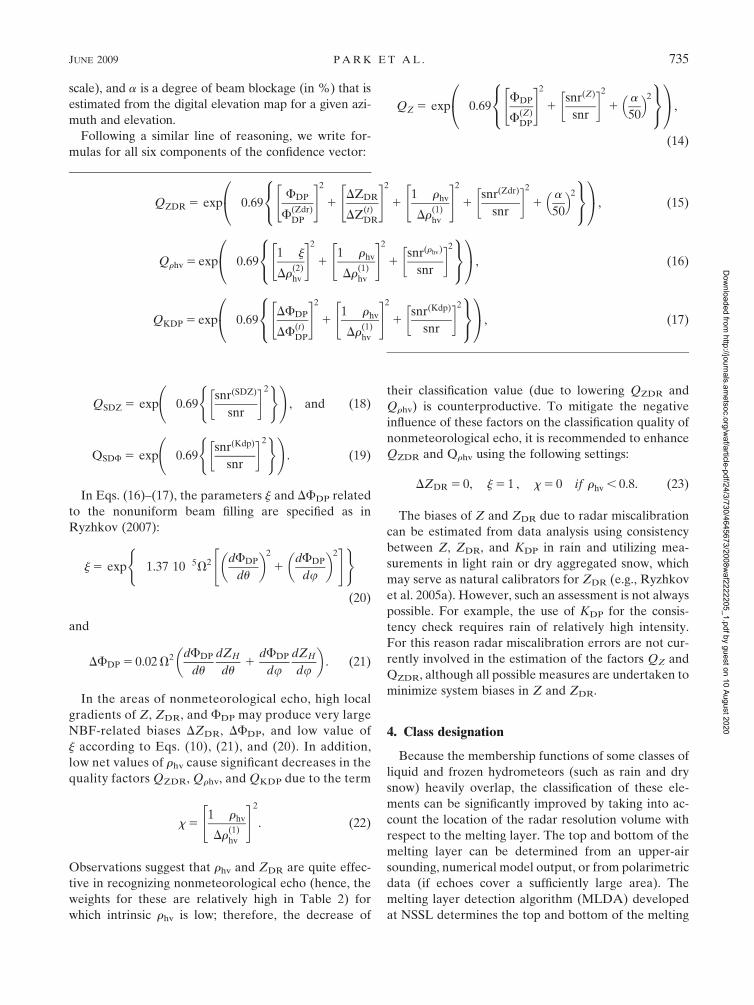
scale), and a is a degree of beam blockage (in %) that is
estimated from the digital elevation map for a given azi-
muth and elevation.
Following a similar line of reasoning, we write for-
mulas for all six components of the confidence vector:
QZ 5 exp �0.69FDP
F(Z)DP
" #2
1snr(Z)
snr
� �21
a
50
� �2
8<:
9=;
0@
1A,
(14)
QSDZ 5 exp �0.69snr(SDZ)
snr
� �2( ) !
, and (18)
QSDF 5 exp �0.69snr(Kdp)
snr
� �2( ) !
. (19)
In Eqs. (16)–(17), the parameters j and DFDP related
to the nonuniform beam filling are specified as in
Ryzhkov (2007):
j 5 exp �1.37 10�5V2 dFDP
du
� �2
1dFDP
du
� �2" #( )
(20)
and
DFDP 5 0.02 V2 dFDP
du
dZH
du1
dFDP
dudZH
du
� �. (21)
In the areas of nonmeteorological echo, high local
gradients of Z, ZDR, and FDP may produce very large
NBF-related biases DZDR, DFDP, and low value of
j according to Eqs. (10), (21), and (20). In addition,
low net values of rhv cause significant decreases in the
quality factors QZDR, Qrhv, and QKDP due to the term
x 51� rhv
Dr(1)hv
" #2
. (22)
Observations suggest that rhv and ZDR are quite effec-
tive in recognizing nonmeteorological echo (hence, the
weights for these are relatively high in Table 2) for
which intrinsic rhv is low; therefore, the decrease of
their classification value (due to lowering QZDR and
Qrhv) is counterproductive. To mitigate the negative
influence of these factors on the classification quality of
nonmeteorological echo, it is recommended to enhance
QZDR and Qrhv using the following settings:
DZDR 5 0, j 5 1 , x 5 0 if rhv , 0.8. (23)
The biases of Z and ZDR due to radar miscalibration
can be estimated from data analysis using consistency
between Z, ZDR, and KDP in rain and utilizing mea-
surements in light rain or dry aggregated snow, which
may serve as natural calibrators for ZDR (e.g., Ryzhkov
et al. 2005a). However, such an assessment is not always
possible. For example, the use of KDP for the consis-
tency check requires rain of relatively high intensity.
For this reason radar miscalibration errors are not cur-
rently involved in the estimation of the factors QZ and
QZDR, although all possible measures are undertaken to
minimize system biases in Z and ZDR.
4. Class designation
Because the membership functions of some classes of
liquid and frozen hydrometeors (such as rain and dry
snow) heavily overlap, the classification of these ele-
ments can be significantly improved by taking into ac-
count the location of the radar resolution volume with
respect to the melting layer. The top and bottom of the
melting layer can be determined from an upper-air
sounding, numerical model output, or from polarimetric
data (if echoes cover a sufficiently large area). The
melting layer detection algorithm (MLDA) developed
at NSSL determines the top and bottom of the melting
QZDR 5 exp �0.69FDP
F(Zdr)DP
" #2
1DZDR
DZ(t)DR
" #2
11� rhv
Dr(1)hv
" #2
1snr(Zdr)
snr
� �21
a
50
� �2
8<:
9=;
0@
1A, (15)
Qrhv 5 exp �0.691� j
Dr(2)hv
" #2
11� rhv
Dr(1)hv
" #2
1snr(rhv)
snr
� �28<:
9=;
0@
1A, (16)
QKDP 5 exp �0.69DFDP
DF(t)DP
" #2
11� rhv
Dr(1)hv
" #2
1snr(Kdp)
snr
� �28<:
9=;
0@
1A, (17)
JUNE 2009 P A R K E T A L . 735
Dow
nloaded from http://journals.am
etsoc.org/waf/article-pdf/24/3/730/4645673/2008w
af2222205_1.pdf by guest on 10 August 2020

layer as a function of the azimuth for any given radar
scan (Giangrande et al. 2008). The MLDA identifies
radar ranges where rhv is between 0.90 and 0.97 for el-
evation angles between 48 and 108. If the maxima of
Z between 30 and 47 dBZ and ZDR between 0.8 dB
and 2.5 dB are observed in a 500-m-thick horizontal
layer just above the height of the range gate where
0.90 , rhv , 0.97, then this range and its corresponding
height identify the melting layer. This routine is re-
peated for each azimuth and the resulting cluster of
melting layer points is used to determine the top (Ht)
and bottom (Hb) heights of the melting layer as func-
tions of the azimuth.
Checking the consistency of the designated class with
the location of the melting layer is an important part of
the classification routine. The geometry of the radar
beam with respect to the melting layer is illustrated in
Fig. 2; the slant ranges Rb and Rt correspond to geo-
metrical projections of the melting layer onto the cone
generated by the beam center at the lowest tilt. In fact,
mixed-phase hydrometeors partially fill the radar reso-
lution volume in a much broader interval of ranges
(Rbb, Rtt) due to the antenna beamwidth. Once the
boundaries of the melting layer are determined, the
fuzzy logic aggregation (3) and classification procedure
are applied with two restrictions: snow is not allowed
below the ML bottom and pure rain is prohibited above
the ML top except for the big-drops category; these are
commonly transported by convective updrafts well above
the environmental freezing level.
The following subsets of classes are allowed within
five slant range intervals:
0 , R , Rbb—GC/AP, BS, BD, RA, HR, RH;
Rbb , R , Rb—GC/AP, BS, WS, GR, BD, RA, HR, RH;
Rb , R , Rt—GC/AP, BS, DS, WS, GR, BD, RH;
Rt , R , Rtt—GC/AP, BS, DS, WS, CR, GR, BD, RH;
and
R . Rtt—DS, CR, GR, RH.
(24)
Additional routines in the HCA include separation of
convective and stratiform echoes, checks if the results
are reasonable, and despeckling. Identifying convective
and stratiform parts of a radar echo helps to better
discriminate between wet snow and melting graupel
within the melting layer. The algorithm for identifying
convective echoes is similar to the method developed by
Zhang et al. (2008). It is based on detecting high values
in the observed vertical profiles of reflectivity and the
top of the melting layer (typically coincident with the
08C wet-bulb temperature height) derived from polari-
metric variables. Polarimetric data with rhv less than 0.85
are considered to be contaminated by nonmeteorological
scatterers (Giangrande and Ryzhkov 2008) and are tag-
ged prior to the convective identification procedure. To
discriminate between convective and stratiform echoes,
the radar reflectivity at a given slant range and azimuth is
examined for all elevations. This slant range and azimuth
are identified as belonging to the convective echo if the
maximum reflectivity in the vertical column is higher
than 45 dBZ or Z is higher than 30 dBZ at altitudes of
1.6 km or higher above the melting layer top. If the echo
is classified as convective, then dry snow and wet snow
(DS and WS) are not allowed within a whole vertical
column. Conversely, the ‘‘convective’’ hydrometeor types
such as BD, GR, and RH are excluded in the stratiform
case.
To check if the results are reasonable, a set of ‘‘hard
thresholds’’ is used, thereby reducing the number of
clearly wrong class designations; for example, hail is
considered to be misclassified if Z , 40 dBZ. In such
cases the algorithm accepts the class with the next
highest aggregation value. The set of such checks or
rules is presented in Table 3. These checks are based on
physical models and the results of observations and are
FIG. 2. Geometry of the radar beam with respect to the melting
layer. The beam axis is drawn with the thick solid line whereas the
locations of the 60.58 beam extent (3-dB beamwidth) are indicated
with the dashed curves. Dotted lines indicate slant ranges Rbb, Rb,
Rt, and Rtt, corresponding to geometrical projections of the
melting layer from the radar beam onto the base tilt. The heights
Hb and Ht represent the melting layer bottom and top heights,
respectively.
736 W E A T H E R A N D F O R E C A S T I N G VOLUME 24
Dow
nloaded from http://journals.am
etsoc.org/waf/article-pdf/24/3/730/4645673/2008w
af2222205_1.pdf by guest on 10 August 2020

consistent with the results in the Straka et al. (2000)
overview.
The despeckling procedure eliminates isolated inci-
dents of misclassification within fields of relatively uni-
form classes, hence producing a less noisy outcome.
5. Results of classification for the MCS case on13 May 2005
The performance of the HCA is illustrated for
the case of an MCS that developed over northwest-
ern Oklahoma and moved eastward through central
Oklahoma on 13 May 2005. The storm was observed
by the National Oceanic and Atmospheric Adminis-
tration (NOAA)/NSSL polarimetric ‘‘proof of con-
cept’’ WSR-88D radar (KOUN hereafter). KOUN
data were collected at 15 antenna elevations (0.08,
0.438, 1.48, 2.58, 3.58, 4.58, 5.58, 6.58, 7.58, 8.78, 10.08,
12.08, 14.08, 16.78, and 19.58) with a volume update time
of about 6 min. Absolute calibration of Z was made
by checking its consistency with KDP measurements
(Ryzhkov et al. 2005a) in areas of moderate to heavy
rain with Z . 40 dBZ and via cross comparison with the
operational Oklahoma City, Oklahoma (KTLX), WSR-
88D radar, which is located about 20 km from KOUN.
Following Ryzhkov et al. (2005a), the differential re-
flectivity was calibrated using the measurements of ZDR
in dry aggregated snow slightly above the melting layer
in the stratiform part of the MCS. Future calibration on
the operational dual-polarization radar network will be
automated (at the end of each volume scan as is done
presently for reflectivity measurements). This will be
augmented by more extensive checks daily and monthly.
Similar approaches will be used for the differential re-
flectivity whereby the augmented checks will involve
comparisons with sun scans. These approaches were not
available at KOUN in May 2005. Hence, the manual and
postoperational calibrations were required.
a. Estimation of the confidence vector
Gradients of Z and ZDR, and values of rhv, SNR, and
FDP all affect the confidence vector. Figure 3 shows a
composite 0.438 elevation plan position indicator (PPI)
display of Z, ZDR, FDP, rhv, and SNR at 0646 UTC. A
decrease in rhv along the southern flank of the squall
line is notable at distances beyond 140–150 km. This is a
clear manifestation of nonuniform beam-filling effects,
which were estimated from the analysis of the vertical
and horizontal gradients of Z, ZDR, and rhv as pre-
scribed by Eqs. (10), (20), and (21). The gradients were
computed from the differences between the radar var-
iables at adjacent radials spaced by 18 in the azimuth
and the elevation. Antenna elevations of 0.438 and 1.48
were used to compute the vertical gradients. Large
vertical and azimuthal gradients of the differential
phase at longer distances along the squall line contrib-
ute significantly to the biases in rhv and FDP (Fig. 4),
with the vertical gradient of FDP being primarily re-
sponsible for the large NBF-related errors in this area.
The NBF bias in ZDR is highest within the melting layer
(Fig. 4) because vertical gradients of Z and ZDR are high
there [see Eq. (10)].
The fields of the confidence factors of Z, ZDR, KDP,
and rhv are displayed in Fig. 5. The confidence factors
QZ, QZDR, QKDP, and Qrhv were determined using
Eqs. (14)–(17), where
F(Z)DP 5 F
(Zdr)DP 5 2508, DF
(t)DP 5 108,
Dr(1)hv
5 0.2, Dr(2)hv
5 0.1, DZ(t)DR 5 0.5 dB,
SNR(Z) 5 SNR(Kdp) 5 0 dB, and
SNR(Zdr) 5 SNR(rhv) 5 5 dB.
(25)
The choice of threshold parameters in (25) was based on
a theoretical analysis of the measurement errors caused
by low rhv and SNR (Bringi and Chandrasekar 2001;
Melnikov and Zrni�c 2007) and NBF (Ryzhkov 2007).
As can be deduced from Eqs. (14)–(17), the confi-
dence factors of the three polarimetric variables are
mainly affected by NBF and the magnitude of rhv, which
determines the noisiness of the polarimetric measure-
ments. For this reason, the largest drop in the confi-
dence factors for ZDR, KDP, and rhv is observed in the
areas of the large gradients of FDP (west-southwest
from the radar) and within the melting layer where in-
trinsic values of the cross-correlation coefficients are
low. All confidence factors decrease at the periphery of
the radar echo due to a reduction in the signal-to-noise
ratio. The radar reflectivity is less affected by this re-
duction compared to polarimetric variables and there-
fore is the most reliable classification parameter in the
areas of weak weather radar echo.
TABLE 3. Empirical hard thresholds used to suppress apparently
wrong designations. Function f2(Z) is determined by Eq. (4).
Variables Thresholds Suppressed class
V .1 m s21 GC/AP
rhv .0.97 BS
ZDR .2 dB DS
Z ,20 dBZ WS
ZDR ,0 dB WS
Z .40 dBZ CR
Z ,10 Z or .60 dBZ GR
ZDR ,f2(Z) – 0.3 BD
Z .50 dBZ RA
Z ,30 dBZ HR
Z ,40 dBZ RH
JUNE 2009 P A R K E T A L . 737
Dow
nloaded from http://journals.am
etsoc.org/waf/article-pdf/24/3/730/4645673/2008w
af2222205_1.pdf by guest on 10 August 2020

FIG. 3. Composite plot of (top left) Z, (top right) ZDR,
(middle left) FDP, (middle right) rhv, and (bottom left)
SNR at a 0.438 elevation angle measured by KOUN at
0646 UTC 13 May 2005. Contours represent slant ranges
Rbb, Rb, Rt, and Rtt (associated with the melting layer) as
functions of the azimuth.
738 W E A T H E R A N D F O R E C A S T I N G VOLUME 24
Dow
nloaded from http://journals.am
etsoc.org/waf/article-pdf/24/3/730/4645673/2008w
af2222205_1.pdf by guest on 10 August 2020

In the region of clear-air echo (SE quadrant), the con-
fidence factors for Z and KDP are almost identical because
both are primarily determined by SNR as condition (23)
is applied. The confidence factors for ZDR and rhv are
alike in that region for the same reason.
b. Melting-layer detection
Once the confidence factors are determined and ag-
gregation values are computed, the top and bottom of the
melting layer are estimated at each azimuth to constrain
the classes into the permissible subsets listed in (24).
Figure 6 displays the melting-layer polarimetric sig-
natures at an elevation of 4.58 at 1016 UTC. Note that
both the ZDR and rhv signatures of the melting layer are
well depicted in the convective part of the storm in the
SE sector where a conventional radar reflectivity factor
shows only a hint of the bright band. The outcome of the
routine for estimating the melting-layer top and bottom
heights Ht and Hb suggested by Giangrande et al. (2008)
is illustrated in Fig. 7a. In each azimuthal direction, a
histogram of the heights of the radar resolution volumes
belonging to the melting layer (i.e., ML points displayed
as black dots in Fig. 7a) is examined and its 20% and
80% percentiles are utilized to define Ht and Hb. The
corresponding contours of Rbb, Rb, Rt, and Rtt deter-
mined in Fig. 2 are overlaid in Figs. 3–5.
According to Giangrande et al. (2008), the top of the
melting layer derived from polarimetric measurements
approximates the height of the 08 wet-bulb temperature
with an RMS error of about 0.2 km in most cases.
FIG. 4. Composite plot of (top left) ZDR bias, (top right)
FDP bias, and (bottom left) rhv multiplicative factor (z) at a
0.438 elevation angle at 0646 UTC 13 May 2005. Contours
indicate slant ranges Rbb, Rb, Rt, and Rtt (associated with the
melting layer) as functions of the azimuth.
JUNE 2009 P A R K E T A L . 739
Dow
nloaded from http://journals.am
etsoc.org/waf/article-pdf/24/3/730/4645673/2008w
af2222205_1.pdf by guest on 10 August 2020

Comparison with sounding data obtained near the radar
location at 1200 UTC in clear atmosphere after the storm
passed over the radar (Fig. 7b) indicates that the mean
ML top (averaged over all azimuths) is at the tempera-
ture of about 28C, or 300 m below the 08C isotherm. Such
a discrepancy is attributed to relatively low humidity
(70%–80%) at the 08C isotherm level; hence, the wet-
bulb temperature is still below zero at this height. In fact,
the difference between the measured temperature and
the wet-bulb temperature is about 28C. Melting starts
where wet-bulb temperature exceeds 08C (dash–dot line
in Fig. 7b).
c. Classification results
HCA output at the base elevation of 0.438 is displayed
in Fig. 8 for 0646 and 0934 UTC. Although it is not
possible to verify the HCA output by comparisons with
in situ measurements, the results of the classification in
both panels in Fig. 8 fit the accepted microphysical
conceptual models of trailing stratiform MCSs (Houze
et al. 1989). At 0646 UTC, biological scatterers and
ground clutter (two shades of blue) are identified ahead
of the squall line. The leading edge of the squall line is
marked by a thin line of big drops associated with size
FIG. 5. Composite plot of the confidence factors of (top left) Z, (top right) ZDR, (bottom left) KDP, and (bottom right) rhv at a 0.438
elevation angle at 0646 UTC 13 May 2005. The slant ranges Rbb, Rb, Rt, and Rtt (associated with the melting layer) as functions of azimuth
are overlaid on the image as contours.
740 W E A T H E R A N D F O R E C A S T I N G VOLUME 24
Dow
nloaded from http://journals.am
etsoc.org/waf/article-pdf/24/3/730/4645673/2008w
af2222205_1.pdf by guest on 10 August 2020

sorting caused by updrafts and wind shear (Wakimoto
and Bringi 1988; Kumjian and Ryzhkov 2008). It is fol-
lowed by heavy rain (dark shade of red) and occasional
regions of hail (pink). A gradual transition from rain to
wet snow (green), dry snow (blue), and crystals (dark
shade of green) is clear in the stratiform part of MCS once
the radar beam approaches and overshoots the melting
level. Elevated areas of graupel (yellow) are evident in
the convective part of the storm at its southern flank.
Three hours later, at 0934 UTC, convective updrafts
persist along the leading edge of the squall line. Ahead
of the convective core of precipitation is the edge of the
gust front, which, according to the algorithm, contains
biological scatterers. Graupel at heights over 2 km
above ground and hail are also identified at the southern
flank of the storm, whereas the transition from rain to wet
snow, dry snow, and crystals is preserved at its northern
flank. Notable is the appearance of the ground clutter
behind the storm, which is caused by superrefraction
(anomalous propagation) in the post-MCS environment.
To evaluate the impacts of newly added features on
the performance of HCA, we compare the classification
results obtained with the latest version of the classifi-
cation algorithm in Fig. 8 with the outputs of two
aborted versions of HCA (Fig. 9). In both simplified
versions, all elements of the matrix of weights W and the
confidence vector Q are set to 1, antenna beam broad-
ening is not taken into account, and no vertical conti-
nuity check is performed to distinguish between the
convective and stratiform parts of the storm. The top
FIG. 6. Composite plot of (top left) Z, (top right) ZDR, and
(bottom left) rhv at the 4.58-elevation angle at 1016 UTC 13
May 2005.
JUNE 2009 P A R K E T A L . 741
Dow
nloaded from http://journals.am
etsoc.org/waf/article-pdf/24/3/730/4645673/2008w
af2222205_1.pdf by guest on 10 August 2020

panels in Fig. 9 illustrate the results of the classification
if no information about the melting layer is taken into
consideration. This information was utilized to make
the HCA outputs shown in the bottom panels of Fig. 9.
Note that the membership functions P(i)(Vj) were the
same for all three versions of HCA.
There are similarities and significant differences be-
tween the classification products in Figs. 8 and 9. All
three versions of HCA reliably distinguish between
meteorological and nonmeteorological radar echoes
and identify heavy rain and hail in the same areas.
However, the designations of other hydrometeor classes
are vastly different. Numerous false designations of
frozen particles (such as dry snow or crystals) below the
freezing level are visible in the HCA product if the in-
formation about melting layer is ignored (top panels in
Fig. 9). This is due to the fact that the membership
functions corresponding to some categories of liquid
and frozen hydrometeors heavily overlap (see Table 1).
Incorporating information about the melting layer helps
to mitigate this deficiency, but ignoring antenna beam
broadening results in artificial circular boundaries and
in underestimating the impact of the wet snow contri-
bution on the radar polarimetric variables. The areas of
rain and snow in Fig. 8 look more uniform and contain
fewer speckles compared to the corresponding areas in
Fig. 9 due to the application of weights, confidence fac-
tors, vertical continuity checks, and the hard thresholds
from Table 3. Overall, the comparison of Figs. 8 and 9
shows that supplementary routines and checks added to
the ‘‘core fuzzy logic procedure’’ with the same mem-
bership functions have a significant impact on the results
of the classification.
Although the classification results presented in Fig. 8
seem quite reasonable, some deficiencies are also no-
ticeable. These include apparent misclassifications at the
two NE azimuthal directions (right panel in Fig. 8) where
partial beam blockage occurs due to two towers, the
impact of which cannot be accounted for using the digital
elevation map, that is, utilizing factor a in Eqs. (14) and
(15). Another concern is the appearance of rain within
the melting layer and the artificial-looking boundary
along Rb at the northern flank of the MCS in the left
panel in Fig. 8. These and other potential shortcomings
will be addressed in future enhancements to the HCA.
Classification is performed at each antenna elevation
and two vertical cross sections of the results constructed
from the series of conical scans are in Figs. 10 and 11 . In
Fig. 10, the bright band is identified as wet snow (light
green) and separates dry snow and rain in the stratiform
part of the storm. In the storm’s convective part, graupel
is shown in yellow and hail in pink. Hail is aloft (two
small areas) and likely melts completely before reaching
the ground. Ice crystals abound at more than 2 km
above ground while dry snow is prevalent at over 3.1 km;
biological scatterers are recognized in the boundary layer
ahead of the storm at distances beyond 95 km from the
radar.
In the more intense part of the storm illustrated in
Fig. 11, the bulk of the hydrometeors identified as
graupel and large drops fill a larger volume than in the
less intense part (Fig. 10). A vertical ZDR column, which
is clearly visible between 40 and 50 km and collocated
with a region of relatively low reflectivity, is associated
with big drops that are suspended in a convective up-
draft. Again, two vertically elongated regions in the
FIG. 7. Results of (a) the polarimetric melting-layer detection
for the volume scan illustrated in Fig. 6 and (b) the sounding. In
(a), ML top and bottom heights AGL are displayed with thick solid
lines. In (b), the temperature (thin solid line), dewpoint (dotted
line), and wet-bulb temperature (dashed–dotted line) are plotted
from sounding data launched near KOUN at 1200 UTC 13 May
2005; the mean ML top and bottom heights designated from the
radar are superimposed with thick solid lines and the 08C line is
plotted with a vertical dashed line.
742 W E A T H E R A N D F O R E C A S T I N G VOLUME 24
Dow
nloaded from http://journals.am
etsoc.org/waf/article-pdf/24/3/730/4645673/2008w
af2222205_1.pdf by guest on 10 August 2020

height interval between 1 and 3.5 km are recognized as a
hail–rain mixture (pink).
These examples illustrate how HCA provides new,
important information for operational meteorologists.
First of all, it clearly delineates meteorological and non-
meteorological echoes including the one caused by the
anomalous propagation in the areas of cold thunderstorm
outflow (right panel in Fig. 8). It allows for monitoring
of the height and depth of the melting layer and their
changes due to frontal passages. Indeed, the comparison
of the dotted circular curves in the left and right panels
of Fig. 8 indicates that the melting layer descends in the
course of 3 h; that is, the radii of the curves become
smaller. This corresponds to the decrease of the melting-
layer height by more than 0.6 km. Detection of the
melting layer, which often descends to the ground dur-
ing the cold season, is crucial for delineating rain and
snow in winter storms (Ryzhkov and Zrni�c 1998).
The big-drop signature is especially helpful for as-
sessing the stage of convective development. Indeed,
‘‘ZDR columns,’’ which may be identified with the HCA
as big drops above the freezing level, signify updrafts
FIG. 8. Fields of (top) radar reflectivity and (bottom) classification results displayed as a PPI at the 0.438 elevation angle at (left) 0646
and (right) 0934 UTC on 13 May 2005. Contours indicate slant ranges Rbb, Rb, Rt, and Rtt (associated with the melting layer) as functions
of the azimuth.
JUNE 2009 P A R K E T A L . 743
Dow
nloaded from http://journals.am
etsoc.org/waf/article-pdf/24/3/730/4645673/2008w
af2222205_1.pdf by guest on 10 August 2020

and convective initiation. The areas of big drops at the
leading edge of the squall line (left panel in Fig. 8)
manifest three microphysical processes: differential sed-
imentation at the onset of precipitation (larger raindrops
fall faster and reach the surface ahead of smaller ones),
unidirectional wind shear, and size sorting within an
updraft. In the case of a supercell storm, the big-drop
signature in the southern part of the forward-flank
downdraft signifies veering of the wind and enhanced
storm-relative helicity (Kumjian and Ryzhkov 2008). It
should be noted that melting graupel–hail in the storm
downdrafts also may produce very high ZDR, which is
usually associated with high Z and is not classified by
our scheme as big drops.
The graupel and rain–hail categories help to pinpoint
locations of possible hail development and help
to monitor how hail descends to the ground, as seen in
Figs. 10 and 11. In addition to monitoring descending
hail, HCA can also help determine if hail melts prior to
reaching the ground by examining the lowest HCA tilt.
If there is no hail on the lowest tilt below the melting
layer, then no hail should be reaching the ground.
FIG. 9. As in Fig. 8, but here the classification was performed with two aborted versions of HCA: (all panels) beam broadening is not
taken into account, and there is no vertical continuity check W5 1, Q5 1; (top) melting layer information is not used; and (bottom)
melting layer information is utilized.
744 W E A T H E R A N D F O R E C A S T I N G VOLUME 24
Dow
nloaded from http://journals.am
etsoc.org/waf/article-pdf/24/3/730/4645673/2008w
af2222205_1.pdf by guest on 10 August 2020

In addition to the information provided for operational
forecasters, the classification product greatly benefits
quantitative precipitation estimation because it reveals
the appropriate rainfall relation that should be applied
to the observed hydrometeor class (Giangrande and
Ryzhkov 2008).
6. Summary and conclusions
A proposed methodology for classifying hydrome-
teors using dual-polarization WSR-88D radars is pre-
sented. The algorithm builds on several previous ver-
sions and has been accepted for the first software release
on the upgraded network. It enables discrimination
between 10 different classes (rain, heavy rain, rain/
hail, big drop, wet snow, dry snow, graupel, crystals,
biological scatterers, and ground clutter); hence, it can
be used to discriminate between hydrometeor types
in both warm-season and cold-season precipitation
systems. The main goal of the improved version is to
provide users with a product that identifies important
precipitation classes (hail, heavy rain, attributes of the
FIG. 10. Composite plot of (top left) Z, (top right) ZDR, (bottom left) rhv, and (bottom right) the results of hydrometeor classification in
the RHI cross section at 1013 UTC 13 May 2005. The azimuth angle is 1568. Dotted lines indicate slant ranges Rbb, Rb, Rt, and Rtt
(associated with the melting layer) at the azimuth.
JUNE 2009 P A R K E T A L . 745
Dow
nloaded from http://journals.am
etsoc.org/waf/article-pdf/24/3/730/4645673/2008w
af2222205_1.pdf by guest on 10 August 2020

melting layer) while minimizing the occurrence of ob-
vious misclassifications. Novel features have been in-
troduced to meet this goal.
The first new feature introduced is the confidence
vector, which quantifies the quality of each radar variable
estimate. Nonuniform beam filling, attenuation, statisti-
cal errors, partial beam blockage, and noise all affect the
quality of the classification scheme. The impacts of all of
these factors on radar measurements are gauged using
Gaussian functions as additional weights in the fuzzy
logic scheme. It is possible to use the confidence factor
statistically by assigning a threshold that, if exceeded,
indicates that the classification results are acceptable; this
nonetheless has not been done in the present study.
Next, the algorithm applies a matrix of weights so that
each pair of a radar variable (six) and class (ten) gets a
unique weight. The weights are chosen to favor a class
that the value of the variable can identify particularly
well. In this manner the classification potency of a var-
iable to characterize a particular hydrometeor class is
exploited.
The algorithm also determines the top and bottom
heights of the melting layer for every azimuthal angle
about the radar site. It then combines the principles of
FIG. 11. As in Fig. 10, except the data are taken at 0646 UTC 13 May 2005 and the azimuth angle is 2528.
746 W E A T H E R A N D F O R E C A S T I N G VOLUME 24
Dow
nloaded from http://journals.am
etsoc.org/waf/article-pdf/24/3/730/4645673/2008w
af2222205_1.pdf by guest on 10 August 2020

class designation relative to the location of the melting
layer with the fuzzy logic approach, taking into account
the broadening of the radar beam at longer distances. This
can make the separation of liquid and frozen hydrome-
teors much more realistic. As a consequence, it is possible
to provide a higher probability of correct classification and
reduce the occurrence of apparently erroneous class
designations in the field of classification results.
Finally, vertical continuity checks are applied to bet-
ter distinguish between convective parts of the storm
associated with dry–wet graupel aloft and its stratiform
region where rain originates from dry–wet snow at
higher levels. This improves the level of discrimination
between graupel and snow.
The hydrometeor classification algorithm was applied
to the mesoscale convective system observed with the
KOUN radar on 13 May 2005. The results of the classi-
fication effectively show heavy rain (occasionally mixed
with hail) and graupel in the convective part of the MCS,
big drops along the leading edge of the squall line, and a
gradual transition from rain to wet snow, dry snow, and
crystals in its trailing stratiform region as the height of the
radar sampling volume increases with distance. Ground
clutter (including that due to anomalous propagation) and
biological scatterers ahead of the storm are also reliably
recognized.
Classification output obtained from polarimetric ra-
dar can be very helpful in the forecast process. It pro-
vides operational meteorologists information about
the origin of a radar echo, the height and depth of the
melting layer, the stage of convective development,
the localization of vertical flows (updrafts–downdrafts),
strong wind shear, and rotation, as well as the capability
for monitoring the development and location of hail.
Although the suggested algorithm demonstrates agree-
ment with conceptual models of MCSs and provides
reasonable classification results for the MCS case on
13 May 2005 (and similar warm-season cases not de-
scribed in the paper), there is room for improvement.
Application to a wider range of weather events, in-
cluding cold-season storms with low melting layers or
the lack of a melting layer, will be examined in future
studies.
Acknowledgments. We express out thanks to Scott
Giangrande and Matthew Kumjian for helpful sugges-
tions. Terry Schuur, Kimberly Elmore, and an anony-
mous reviewer provided comments that have strength-
ened this manuscript. Paul Schlatter’s extensive and
useful review is appreciated as it helped in improving
the paper. This work was funded by the NOAA/Office
of Oceanic and Atmospheric Research under NOAA–
University of Oklahoma Cooperative Agreement
NA17RJ1227, the U.S. Department of Commerce, and
by the U.S. National Weather Service, Federal Aviation
Administration, and Department of Defense program
for modernization of NEXRAD radars. The lead author
was partially supported by the Korea Meteorological
Administration Research and Development Program
under Grant CATER 2007-2104. The authors thank
the NSSL/CIMMS employees who maintain and oper-
ate the KOUN polarimetric radar for research-grade
applications.
REFERENCES
Bringi, V. N., and V. Chandrasekar, 2001: Polarimetric Doppler
Weather Radar: Principles and Applications. Cambridge Uni-
versity Press, 636 pp.
Giangrande, S. E., and A. V. Ryzhkov, 2005: Calibration of dual-
polarization radar in the presence of partial beam blockage.
J. Atmos. Oceanic Technol., 22, 1156–1166.
——, and ——, 2008: Estimation of rainfall based on the results of
polarimetric echo classification. J. Appl. Meteor. Climatol., 47,2445–2462.
——, J. M. Krause, and A. V. Ryzhkov, 2008: Automatic desig-
nation of the melting layer with a polarimetric prototype of
the WSR-88D radar. J. Appl. Meteor. Climatol., 47, 1354–
1364.
Heinselman, P. L., and A. V. Ryzhkov, 2006: Validation of po-
larimetric hail detection. Wea. Forecasting, 21, 839–850.
Houze, R. A., Jr., S. A. Rutledge, M. I. Biggerstaff, and B. F.
Smull, 1989: Interpretation of Doppler weather radar displays
of midlatitude mesoscale convective systems. Bull. Amer.
Meteor. Soc., 70, 608–619.
Keenan, T. D., 2003: Hydrometeor classification with a C-band
polarimetric radar. Aust. Meteor. Mag., 52, 23–31.
Kumjian, M. R., and A. V. Ryzhkov, 2008: Polarimetric signatures
in supercell thunderstorms. J. Appl. Meteor. Climatol., 47,1940–1961.
Lim, S., V. Chandrasekar, and V. N. Bringi, 2005: Hydrometeor
classification system using dual-polarization radar measure-
ments: Model improvements and in situ verification. IEEE
Trans. Geosci. Remote Sens., 43, 792–801.
Liu, H., and V. Chandrasekar, 2000: Classification of hydrome-
teors based on polarimetric radar measurements: Develop-
ment of fuzzy logic and neuro-fuzzy systems, and in situ ver-
ification. J. Atmos. Oceanic Technol., 17, 140–164.
Marzano, F., D. Scaranari, M. Montopoli, and G. Vulpiani, 2008:
Supervised classification and estimation of hydrometeors
from C-band dual-polarized radars: A Bayesian approach.
IEEE Trans. Geosci. Remote Sens., 46, 85–98.
Melnikov, V. M., and D. S. Zrni�c, 2007: Autocorrelation and cross-
correlation estimators of polarimetric variables. J. Atmos.
Oceanic Technol., 24, 1337–1350.
Park, H.-S., A. V. Ryzhkov, D. S. Zrni�c, and K.-E. Kim, 2007:
Optimization of the matrix of weights in the polarimetric al-
gorithm for classification of radar echoes. Preprints, 33rd
Conf. on Radar Meteorology, Cairns, QLD, Australia, Amer.
Meteor. Soc., P11B.4. [Available online at http://ams.confex.
com/ams/pdfpapers/123123.pdf.]
Ryzhkov, A. V., 2007: The impact of beam broadening on the
quality of radar polarimetric data. J. Atmos. Oceanic Technol.,
24, 729–744.
JUNE 2009 P A R K E T A L . 747
Dow
nloaded from http://journals.am
etsoc.org/waf/article-pdf/24/3/730/4645673/2008w
af2222205_1.pdf by guest on 10 August 2020

——, and D. S. Zrni�c, 1995: Precipitation and attenuation mea-
surements at 10-cm wavelength. J. Appl. Meteor., 34, 2121–
2134.
——, and ——, 1996: Assessment of rainfall measurement that uses
specific differential phase. J. Appl. Meteor., 35, 2080–2090.
——, and ——, 1998: Discrimination between rain and snow with a
polarimetric radar. J. Appl. Meteor., 37, 1228–1240.
——, S. E. Giangrande, V. M. Melnikov, and T. J. Schuur, 2005a:
Calibration issues of dual-polarization radar measurements.
J. Atmos. Oceanic Technol., 22, 1778–1785.
——, T. J. Schuur, D. W. Burgess, S. E. Giangrande, and D. S.
Zrni�c, 2005b: The Joint Polarization Experiment: Polarimet-
ric rainfall measurements and hydrometeor classification.
Bull. Amer. Meteor. Soc., 86, 809–824.
——, and Coauthors, 2007: Comparison of polarimetric algorithms
for hydrometeor classification at S and C bands. Analysis of
the performance in different climate regions. Preprints, 33rd
Conf. on Radar Meteorology, Cairns, QLD, Australia, Amer.
Meteor. Soc., 10.3. [Available online at http://ams.confex.
com/ams/pdfpapers/123109.pdf.]
Scharfenberg, K. A., and Coauthors, 2005: The Joint Polarization
Experiment: Polarimetric radar in forecasting and warning
decision making. Wea. Forecasting, 20, 775–788.
Schuur, T. J., A. V. Ryzhkov, and P. L. Heinselman, 2003: Ob-
servations and classification of echoes with the polarimetric
WSR-88D radar. NOAA/National Severe Storms Laboratory
Rep., 46 pp.
Straka, J. M., 1996: Hydrometeor fields in a supercell storm as
deduced from dual-polarization radar. Preprints, 18th Conf.
on Severe Local Storms, San Francisco, CA, Amer. Meteor.
Soc., 551–554.
——, and D. S. Zrni�c, 1993: An algorithm to deduce hydrometeor
types and contents from multiparameter radar data. Preprints,
26th Conf. on Radar Meteorology, Norman, OK, Amer. Me-
teor. Soc., 513–516.
——, ——, and A. V. Ryzhkov, 2000: Bulk hydrometeor classifi-
cation and quantification using polarimetric radar data: Syn-
thesis of relations. J. Appl. Meteor., 39, 1341–1372.
Vivekanandan, J., D. S. Zrni�c, S. Ellis, D. Oye, A. V. Ryzhkov, and
J. M. Straka, 1999: Cloud microphysics retrieval using S-band
dual-polarization radar measurements. Bull. Amer. Meteor.
Soc., 80, 381–388.
Wakimoto, R. M., and V. N. Bringi, 1988: Dual-polarization ob-
servations of microbursts associated with intense convection:
The 20 July storm during the MIST project. Mon. Wea. Rev.,
116, 1521–1539.
Zhang, J., C. Langston, and K. Howard, 2008: Brightband identi-
fication in vertical profiles of reflectivity from the WSR-88D.
J. Atmos. Oceanic Technol., 25, 1859–1872.
Zrni�c, D. S., and A. V. Ryzhkov, 1999: Polarimetry for weather
surveillance radars. Bull. Amer. Meteor. Soc., 80, 389–406.
——, ——, J. M. Straka, Y. Liu, and J. Vivekanandan, 2001:
Testing a procedure for the automatic classification of hy-
drometeor types. J. Atmos. Oceanic Technol., 18, 892–913.
——, V. M. Melnikov, and A. V. Ryzhkov, 2006: Correlation co-
efficients between horizontally and vertically polarized re-
turns from ground clutter. J. Atmos. Oceanic Technol., 23,
381–394.
748 W E A T H E R A N D F O R E C A S T I N G VOLUME 24
Dow
nloaded from http://journals.am
etsoc.org/waf/article-pdf/24/3/730/4645673/2008w
af2222205_1.pdf by guest on 10 August 2020