the impacts of hurricane charley on the southwest florida . neal.pdf · fort myers, fl 33901 . ......
TRANSCRIPT
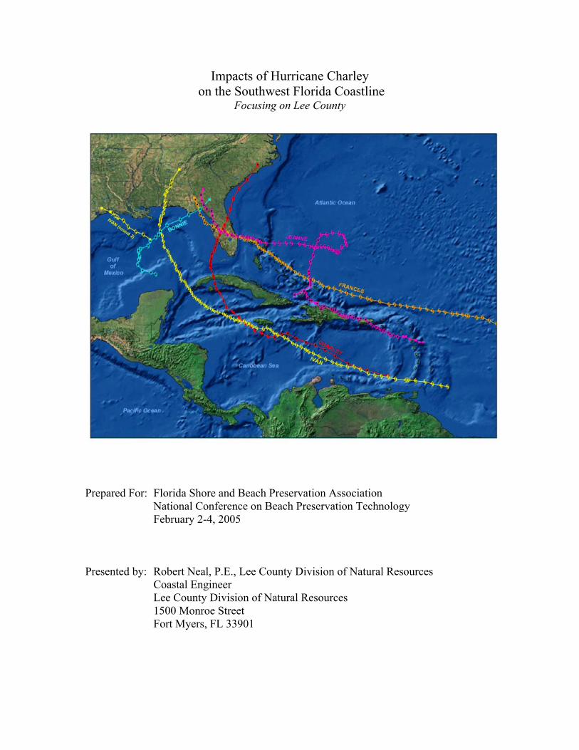
Impacts of Hurricane Charley on the Southwest Florida Coastline
Focusing on Lee County
Prepared For: Florida Shore and Beach Preservation Association National Conference on Beach Preservation Technology February 2-4, 2005 Presented by: Robert Neal, P.E., Lee County Division of Natural Resources Coastal Engineer Lee County Division of Natural Resources 1500 Monroe Street Fort Myers, FL 33901
Impacts of Hurricane Charley on the Southwest Florida Coastline Focusing on Lee County
Pg. 2 of 12
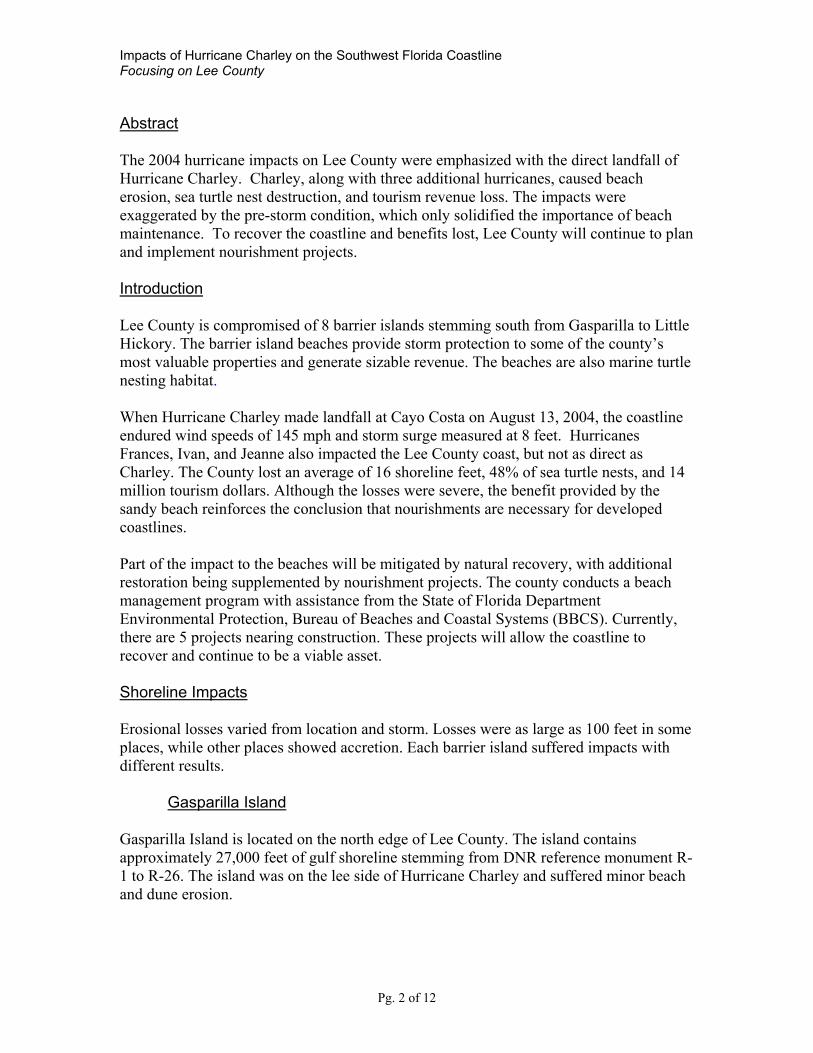
Abstract The 2004 hurricane impacts on Lee County were emphasized with the direct landfall of Hurricane Charley. Charley, along with three additional hurricanes, caused beach erosion, sea turtle nest destruction, and tourism revenue loss. The impacts were exaggerated by the pre-storm condition, which only solidified the importance of beach maintenance. To recover the coastline and benefits lost, Lee County will continue to plan and implement nourishment projects. Introduction Lee County is compromised of 8 barrier islands stemming south from Gasparilla to Little Hickory. The barrier island beaches provide storm protection to some of the county’s most valuable properties and generate sizable revenue. The beaches are also marine turtle nesting habitat. When Hurricane Charley made landfall at Cayo Costa on August 13, 2004, the coastline endured wind speeds of 145 mph and storm surge measured at 8 feet. Hurricanes Frances, Ivan, and Jeanne also impacted the Lee County coast, but not as direct as Charley. The County lost an average of 16 shoreline feet, 48% of sea turtle nests, and 14 million tourism dollars. Although the losses were severe, the benefit provided by the sandy beach reinforces the conclusion that nourishments are necessary for developed coastlines. Part of the impact to the beaches will be mitigated by natural recovery, with additional restoration being supplemented by nourishment projects. The county conducts a beach management program with assistance from the State of Florida Department Environmental Protection, Bureau of Beaches and Coastal Systems (BBCS). Currently, there are 5 projects nearing construction. These projects will allow the coastline to recover and continue to be a viable asset. Shoreline Impacts Erosional losses varied from location and storm. Losses were as large as 100 feet in some places, while other places showed accretion. Each barrier island suffered impacts with different results.
Gasparilla Island Gasparilla Island is located on the north edge of Lee County. The island contains approximately 27,000 feet of gulf shoreline stemming from DNR reference monument R-1 to R-26. The island was on the lee side of Hurricane Charley and suffered minor beach and dune erosion.
Impacts of Hurricane Charley on the Southwest Florida Coastline Focusing on Lee County
Pg. 3 of 12
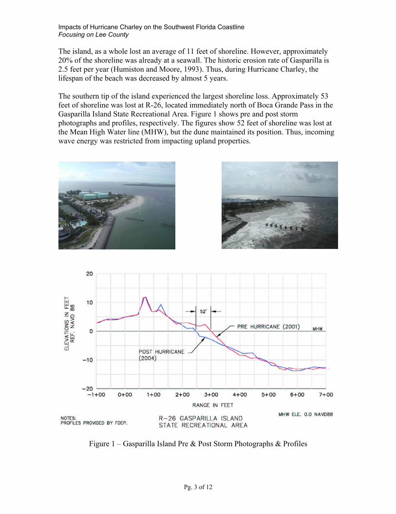
The island, as a whole lost an average of 11 feet of shoreline. However, approximately 20% of the shoreline was already at a seawall. The historic erosion rate of Gasparilla is 2.5 feet per year (Humiston and Moore, 1993). Thus, during Hurricane Charley, the lifespan of the beach was decreased by almost 5 years. The southern tip of the island experienced the largest shoreline loss. Approximately 53 feet of shoreline was lost at R-26, located immediately north of Boca Grande Pass in the Gasparilla Island State Recreational Area. Figure 1 shows pre and post storm photographs and profiles, respectively. The figures show 52 feet of shoreline was lost at the Mean High Water line (MHW), but the dune maintained its position. Thus, incoming wave energy was restricted from impacting upland properties.
Figure 1 – Gasparilla Island Pre & Post Storm Photographs & Profiles
Impacts of Hurricane Charley on the Southwest Florida Coastline Focusing on Lee County
Pg. 4 of 12
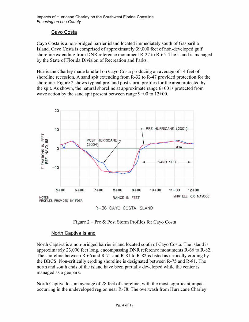
Cayo Costa Cayo Costa is a non-bridged barrier island located immediately south of Gasparilla Island. Cayo Costa is comprised of approximately 39,000 feet of non-developed gulf shoreline extending from DNR reference monument R-27 to R-65. The island is managed by the State of Florida Division of Recreation and Parks. Hurricane Charley made landfall on Cayo Costa producing an average of 14 feet of shoreline recession. A sand spit extending from R-32 to R-47 provided protection for the shoreline. Figure 2 shows typical pre- and post storm profiles for the area protected by the spit. As shown, the natural shoreline at approximate range 6+00 is protected from wave action by the sand spit present between range 9+00 to 12+00.
Figure 2 – Pre & Post Storm Profiles for Cayo Costa
North Captiva Island North Captiva is a non-bridged barrier island located south of Cayo Costa. The island is approximately 23,000 feet long, encompassing DNR reference monuments R-66 to R-82. The shoreline between R-66 and R-71 and R-81 to R-82 is listed as critically eroding by the BBCS. Non-critically eroding shoreline is designated between R-75 and R-81. The north and south ends of the island have been partially developed while the center is managed as a geopark. North Captiva lost an average of 28 feet of shoreline, with the most significant impact occurring in the undeveloped region near R-78. The overwash from Hurricane Charley
Impacts of Hurricane Charley on the Southwest Florida Coastline Focusing on Lee County
Pg. 5 of 12
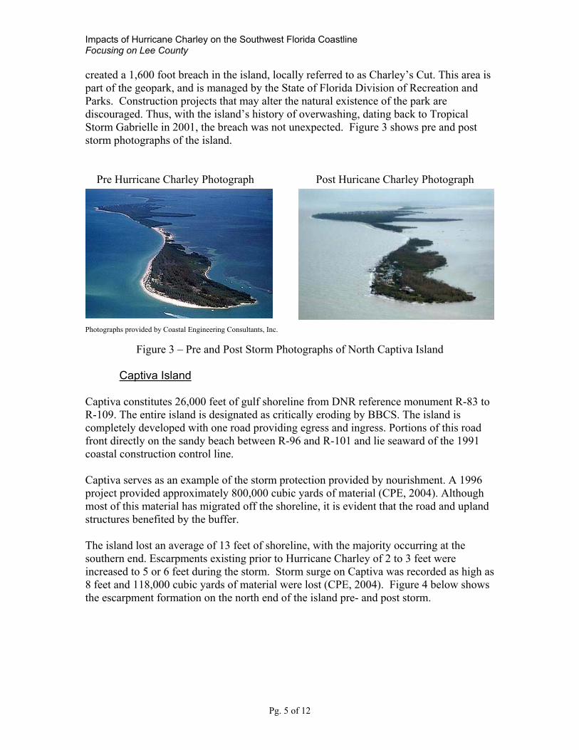
created a 1,600 foot breach in the island, locally referred to as Charley’s Cut. This area is part of the geopark, and is managed by the State of Florida Division of Recreation and Parks. Construction projects that may alter the natural existence of the park are discouraged. Thus, with the island’s history of overwashing, dating back to Tropical Storm Gabrielle in 2001, the breach was not unexpected. Figure 3 shows pre and post storm photographs of the island. Pre Hurricane Charley Photograph Post Huricane Charley Photograph Photographs provided by Coastal Engineering Consultants, Inc.
Figure 3 – Pre and Post Storm Photographs of North Captiva Island
Captiva Island Captiva constitutes 26,000 feet of gulf shoreline from DNR reference monument R-83 to R-109. The entire island is designated as critically eroding by BBCS. The island is completely developed with one road providing egress and ingress. Portions of this road front directly on the sandy beach between R-96 and R-101 and lie seaward of the 1991 coastal construction control line. Captiva serves as an example of the storm protection provided by nourishment. A 1996 project provided approximately 800,000 cubic yards of material (CPE, 2004). Although most of this material has migrated off the shoreline, it is evident that the road and upland structures benefited by the buffer. The island lost an average of 13 feet of shoreline, with the majority occurring at the southern end. Escarpments existing prior to Hurricane Charley of 2 to 3 feet were increased to 5 or 6 feet during the storm. Storm surge on Captiva was recorded as high as 8 feet and 118,000 cubic yards of material were lost (CPE, 2004). Figure 4 below shows the escarpment formation on the north end of the island pre- and post storm.

Impacts of Hurricane Charley on the Southwest Florida Coastline Focusing on Lee County
Pg. 6 of 12
Pre Storm – April 2003 Post Storm – August 2004 Photo provided by FDEP
Figure 4 – Pre and Post Storm Photographs of Captiva Island
Sanibel Island Sanibel is connected to Captiva by Blind Pass. Reference monuments R-110 to R-174 are located on Sanibel’s 66,000 feet of gulf shoreline. The shoreline from R-110 to R-118, and from R-129 to R-133 is designated as critically eroding by BBCS. Sanibel’s average shoreline loss was approximately 7 feet. Storm surge levels also reached 7 feet. Although the average shoreline loss appears minimal, portions of Sanibel lost more than 100 feet. The largest impact occurred in Bowman’s Beach, a county park located at R-118 to R-115. Figure 5 below shows the loss at R-116 reaching 132 feet. This area does not contain major upland structures, but the erosion experienced reinforces the potential for devastation during a storm event.
Figure 5– Shoreline Loss at Bowman’s Beach
Impacts of Hurricane Charley on the Southwest Florida Coastline Focusing on Lee County
Pg. 7 of 12
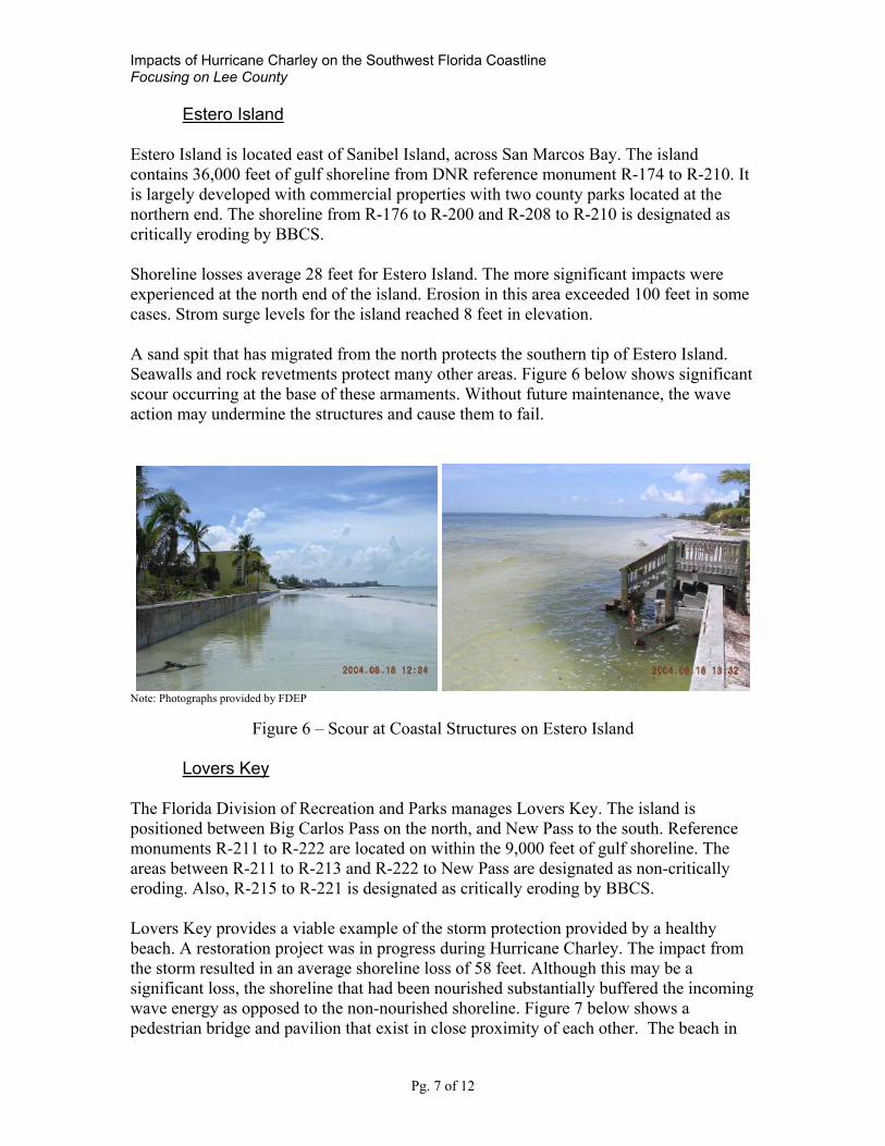
Estero Island Estero Island is located east of Sanibel Island, across San Marcos Bay. The island contains 36,000 feet of gulf shoreline from DNR reference monument R-174 to R-210. It is largely developed with commercial properties with two county parks located at the northern end. The shoreline from R-176 to R-200 and R-208 to R-210 is designated as critically eroding by BBCS. Shoreline losses average 28 feet for Estero Island. The more significant impacts were experienced at the north end of the island. Erosion in this area exceeded 100 feet in some cases. Strom surge levels for the island reached 8 feet in elevation. A sand spit that has migrated from the north protects the southern tip of Estero Island. Seawalls and rock revetments protect many other areas. Figure 6 below shows significant scour occurring at the base of these armaments. Without future maintenance, the wave action may undermine the structures and cause them to fail.
Note: Photographs provided by FDEP
Figure 6 – Scour at Coastal Structures on Estero Island
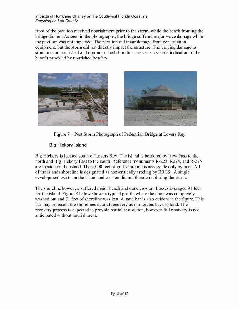
Lovers Key The Florida Division of Recreation and Parks manages Lovers Key. The island is positioned between Big Carlos Pass on the north, and New Pass to the south. Reference monuments R-211 to R-222 are located on within the 9,000 feet of gulf shoreline. The areas between R-211 to R-213 and R-222 to New Pass are designated as non-critically eroding. Also, R-215 to R-221 is designated as critically eroding by BBCS. Lovers Key provides a viable example of the storm protection provided by a healthy beach. A restoration project was in progress during Hurricane Charley. The impact from the storm resulted in an average shoreline loss of 58 feet. Although this may be a significant loss, the shoreline that had been nourished substantially buffered the incoming wave energy as opposed to the non-nourished shoreline. Figure 7 below shows a pedestrian bridge and pavilion that exist in close proximity of each other. The beach in
Impacts of Hurricane Charley on the Southwest Florida Coastline Focusing on Lee County
Pg. 8 of 12
front of the pavilion received nourishment prior to the storm, while the beach fronting the bridge did not. As seen in the photographs, the bridge suffered major wave damage while the pavilion was not impacted. The pavilion did incur damage from construction equipment, but the storm did not directly impact the structure. The varying damage to structures on nourished and non-nourished shorelines serve as a visible indication of the benefit provided by nourished beaches.
Figure 7 – Post Storm Photograph of Pedestrian Bridge at Lovers Key
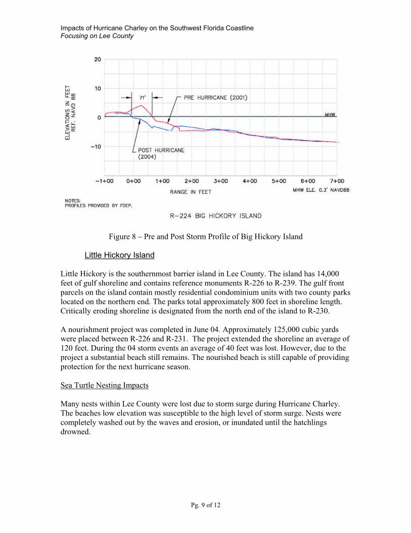
Big Hickory Island Big Hickory is located south of Lovers Key. The island is bordered by New Pass to the north and Big Hickory Pass to the south. Reference monuments R-223, R224, and R-225 are located on the island. The 4,000 feet of gulf shoreline is accessible only by boat. All of the islands shoreline is designated as non-critically eroding by BBCS. A single development exists on the island and erosion did not threaten it during the storm. The shoreline however, suffered major beach and dune erosion. Losses averaged 91 feet for the island. Figure 8 below shows a typical profile where the dune was completely washed out and 71 feet of shoreline was lost. A sand bar is also evident in the figure. This bar may represent the shorelines natural recovery as it migrates back to land. The recovery process is expected to provide partial restoration, however full recovery is not anticipated without nourishment.
Impacts of Hurricane Charley on the Southwest Florida Coastline Focusing on Lee County
Pg. 9 of 12
Figure 8 – Pre and Post Storm Profile of Big Hickory Island
Little Hickory Island Little Hickory is the southernmost barrier island in Lee County. The island has 14,000 feet of gulf shoreline and contains reference monuments R-226 to R-239. The gulf front parcels on the island contain mostly residential condominium units with two county parks located on the northern end. The parks total approximately 800 feet in shoreline length. Critically eroding shoreline is designated from the north end of the island to R-230. A nourishment project was completed in June 04. Approximately 125,000 cubic yards were placed between R-226 and R-231. The project extended the shoreline an average of 120 feet. During the 04 storm events an average of 40 feet was lost. However, due to the project a substantial beach still remains. The nourished beach is still capable of providing protection for the next hurricane season. Sea Turtle Nesting Impacts Many nests within Lee County were lost due to storm surge during Hurricane Charley. The beaches low elevation was susceptible to the high level of storm surge. Nests were completely washed out by the waves and erosion, or inundated until the hatchlings drowned.
Impacts of Hurricane Charley on the Southwest Florida Coastline Focusing on Lee County
Pg. 10 of 12
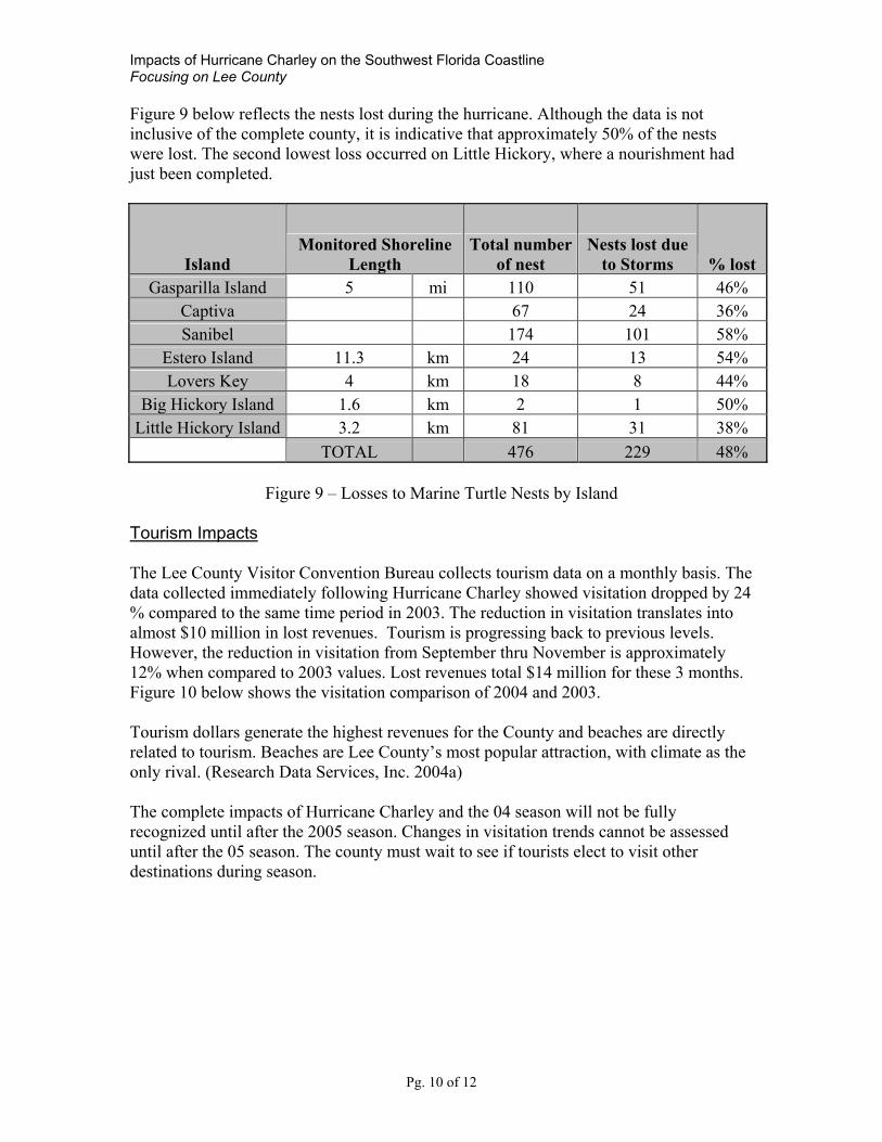
Figure 9 below reflects the nests lost during the hurricane. Although the data is not inclusive of the complete county, it is indicative that approximately 50% of the nests were lost. The second lowest loss occurred on Little Hickory, where a nourishment had just been completed.
Island Monitored Shoreline
Length Total number
of nest Nests lost due
to Storms % lost Gasparilla Island 5 mi 110 51 46%
Captiva 67 24 36% Sanibel 174 101 58%
Estero Island 11.3 km 24 13 54% Lovers Key 4 km 18 8 44%
Big Hickory Island 1.6 km 2 1 50% Little Hickory Island 3.2 km 81 31 38%
TOTAL 476 229 48%
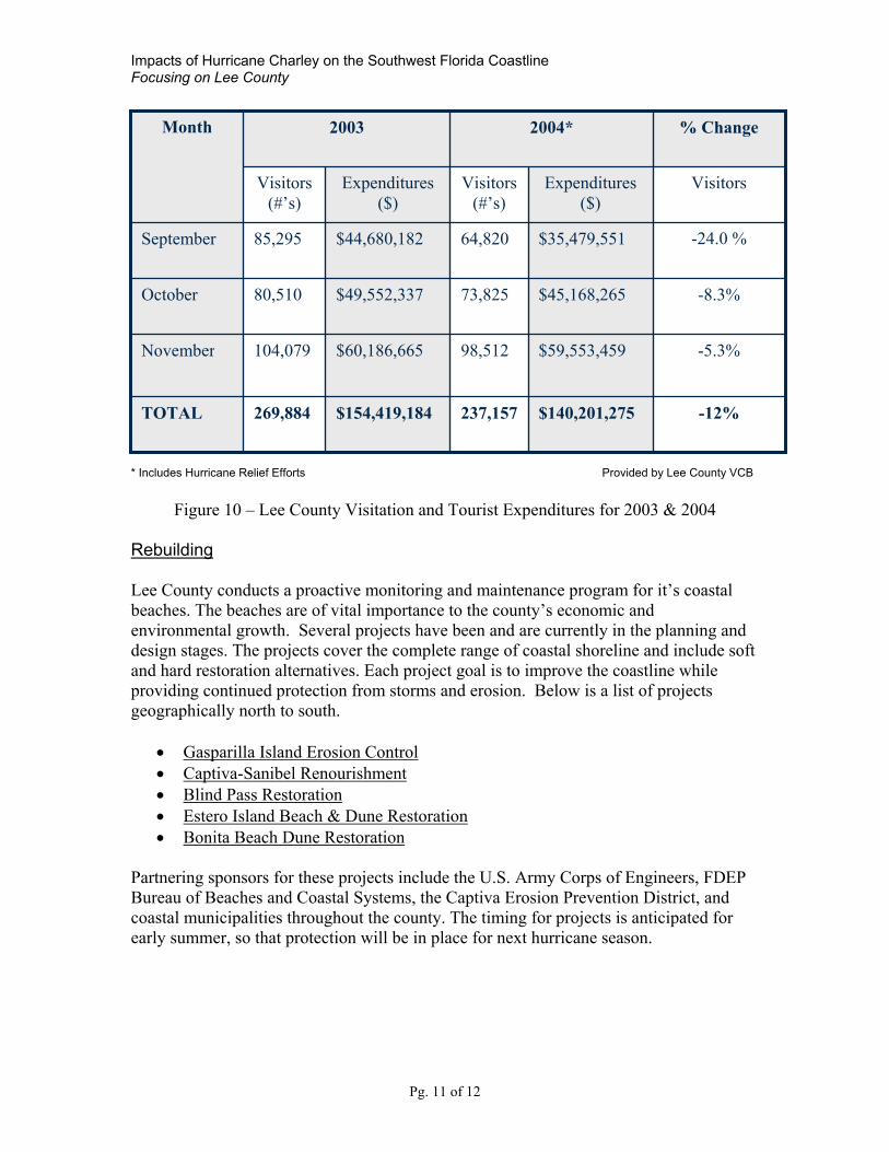
Figure 9 – Losses to Marine Turtle Nests by Island Tourism Impacts The Lee County Visitor Convention Bureau collects tourism data on a monthly basis. The data collected immediately following Hurricane Charley showed visitation dropped by 24 % compared to the same time period in 2003. The reduction in visitation translates into almost $10 million in lost revenues. Tourism is progressing back to previous levels. However, the reduction in visitation from September thru November is approximately 12% when compared to 2003 values. Lost revenues total $14 million for these 3 months. Figure 10 below shows the visitation comparison of 2004 and 2003. Tourism dollars generate the highest revenues for the County and beaches are directly related to tourism. Beaches are Lee County’s most popular attraction, with climate as the only rival. (Research Data Services, Inc. 2004a) The complete impacts of Hurricane Charley and the 04 season will not be fully recognized until after the 2005 season. Changes in visitation trends cannot be assessed until after the 05 season. The county must wait to see if tourists elect to visit other destinations during season.
Impacts of Hurricane Charley on the Southwest Florida Coastline Focusing on Lee County
Pg. 11 of 12
* Includes Hurricane Relief Efforts Provided by Lee County VCB
Figure 10 – Lee County Visitation and Tourist Expenditures for 2003 & 2004
Rebuilding Lee County conducts a proactive monitoring and maintenance program for it’s coastal beaches. The beaches are of vital importance to the county’s economic and environmental growth. Several projects have been and are currently in the planning and design stages. The projects cover the complete range of coastal shoreline and include soft and hard restoration alternatives. Each project goal is to improve the coastline while providing continued protection from storms and erosion. Below is a list of projects geographically north to south.
• Gasparilla Island Erosion Control • Captiva-Sanibel Renourishment • Blind Pass Restoration • Estero Island Beach & Dune Restoration • Bonita Beach Dune Restoration
Partnering sponsors for these projects include the U.S. Army Corps of Engineers, FDEP Bureau of Beaches and Coastal Systems, the Captiva Erosion Prevention District, and coastal municipalities throughout the county. The timing for projects is anticipated for early summer, so that protection will be in place for next hurricane season.
-12% $140,201,275 237,157$154,419,184269,884 TOTAL
-5.3% $59,553,459 98,512 $60,186,665 104,079 November
-8.3% $45,168,265 73,825 $49,552,337 80,510 October
-24.0 %
$35,479,551 64,820 $44,680,182 85,295 September
Visitors
Expenditures ($)
Visitors(#’s)
Expenditures($)
Visitors (#’s)
% Change 2004* 2003 Month

Impacts of Hurricane Charley on the Southwest Florida Coastline Focusing on Lee County
Pg. 12 of 12
Conclusion The impacts of Hurricane Charley and the 04 season imposed on the Lee County shoreline will have a long term ripple effect throughout the county. However, the protection or buffer provided by the sandy beach supports the policy to nourish the shoreline. No major infrastructure was destroyed as a result of wave impact from the storms. The sacrificial beach and coastal structures were able to endure the wave energy cast upon it. As some of the shoreline has been lost and structures threatened, nourishment is imperative for future protection and economic growth. Acknowledgement The Florida Department of Environmental Protection, Bureau of Beaches and Coastal Systems provided the pre- and post- storm surveys for Hurricane Charley. The hard work and dedication of the Department staff is acknowledged and appreciated. References Coastal Planning & Engineering, Inc. (2004, November) 2004 hurricane impacts on
Captiva and Sanibel islands, Florida; Post-Storm survey and report. Boca Raton, Florida.
Florida Department of Environmental Protection (2004, August) Hurricane Charley; post-storm beach conditions and coastal impact report with recommendations for recovery and modifications of beach management strategies. Bureau of Beaches and Coastal Systems, Tallahassee, Florida.
Florida Department of Environmental Protection (2003, August). Critical beach erosion areas in Florida. Bureau of Beaches and Wetland Resources, Tallahassee, Florida.
Humiston and Moore Engineers. (1994, May). Gasparilla island erosion control study. Naples, Florida.
Research Data Services, Inc. (2004a, November) October 2004 visitor profile – Lee County, Tampa, Florida.
Research Data Services, Inc. (2004b, December) November 2004 visitor profile – Lee County, Tampa, Florida.
Research Data Services, Inc. (2005, January) December 2004 visitor profile – Lee County, Tampa, Florida.
Niedoroda, Alan (2005, January) Hurricane Charley:CHWM unit id’s and surveyed elevations. URS Corporation, Tallahassee, Florida [Personal e-mail].