the lancashire county council (torrisholme to the m6 link ... file(v) the construction of hadrian...
TRANSCRIPT

Document Generated: 2019-03-21Status: This is the original version (as it was originally made). Thisitem of legislation is currently only available in its original format.
S C H E D U L E S
SCHEDULE 1 Articles 2 and 3
AUTHORISED DEVELOPMENT
In the City of Lancaster—
A nationally significant infrastructure project as defined in sections 14 and 22 of the 2008 Actcomprising:Work No.1 — he construction of a new dual carriageway road (referred to in this Schedule as“the new road”) 4.8 kilometres in length, starting at A683 Caton Road and ending at the easternend of the Lancaster – Morecambe bypass at the A683/A589 Morecambe Road roundabout,to include—(i) the construction of a new M6 motorway junction 34 to include new northbound and
southbound slip roads to replace the existing;(ii) the construction of a 3 metre wide shared footway and cycle track alongside the new
road westbound carriageway;(iii) the widening of A683 Lancaster - Morecambe bypass from the south of Northgate
junction northwards to A589 Morecambe Road junction;(iv) the remodelling of the Northgate Junction. The construction of a retaining wall to protect
commercial premises from the widening of A683 Lancaster - Morecambe bypass;(v) the construction of Hadrian Junction linking a realigned Hadrian Road to the widened
A683 Lancaster – Morecambe bypass through a new signalised ‘T’ junction;(vi) the replacement of the present roundabout on A589 Morecambe Road near Lancaster and
Morecambe College with a high-capacity, multi-lane signal controlled crossroads withfull pedestrian and cycle facilities;
(vii) the reconfiguration of access, exit and internal circulation to McDonald’s restaurant atCollege junction;
(viii) the construction of Thorpe View underpass to connect the Lancaster and MorecambeCollege campus to severed sports fields west of the new road. Diversion of a streamcurrently running through Lancaster and Morecambe College Campus to a new coursealong the west side of the new road;
(ix) the construction of Torrisholme Road Bridge and realignment of Torrisholme Road,including a connection between the footway and cycle track alongside the new road andTorrisholme Road. Alteration to the sewers from 179 Torrisholme Road;
(x) the realignment of Barley Cop Lane with a new ‘T’ junction with the realignedTorrisholme Road, southwest of its current location and the creation of a two-wayfootway and cycle track to run parallel to Barley Cop Lane from Torrisholme Road toPowder House Lane;
(xi) the installation of highway drainage attenuation pond to the south of the new road in thenarrow triangular area between the new road, Barley Cop Lane and Powder House Lane;
(xii) the reshaping of the field bounded by the new road, the Lancaster Canal, HammertonHall Lane, Barley Cop Lane and Folly Lane to provide essential mitigation;
1

Document Generated: 2019-03-21Status: This is the original version (as it was originally made). Thisitem of legislation is currently only available in its original format.
(xiii) the construction of the diverted Powder House Lane and Folly Lane, the construction ofFolly Railway Bridge, crossing the West Coast Main Line and the diversions of PowderHouse Lane and Folly Lane. Creation of an eastbound lay-by on the new road midwaybetween Torrisholme Road Bridge and Folly Railway Bridge;
(xiv) the construction of Milestone Canal Bridge over the Lancaster Canal. The constructionof an access track linking Hammerton Hall Farm land severed by the new road whichwill pass under the Milestone Canal Bridge;
(xv) the connection of the new footway and cycle track alongside the new road to the towpathalong the west side of the Lancaster Canal;
(xvi) the provision of a westbound lay-by on the new road between the West Coast Main Lineand the Lancaster Canal;
(xvii)the construction of the Lancaster Road Link connecting Beaumont Junction roundabout400 metres to the east of Milestone Canal Bridge with the A6 Lancaster Road via asignal-controlled Lancaster Road Junction, the diversion of the A6 over the new roadvia construction of Lancaster Road Bridge, and the installation of Beaumont JunctionRetaining Wall to protect an electricity transmission tower to the east of BeaumontJunction;.
(xviii)the installation of Beaumont Gate Retaining Wall to protect an electricity transmissiontower between the A6 and Beaumont Gate Occupation Bridge;
(xix) the construction of Beaumont Bridge to carry a realigned Green Lane over the newroad, and the provision of a westbound lay-by on the new road between Beaumont GateOccupation Bridge and Beaumont Bridge;.
(xx) the diversion and culverting of Howgill Brook under the new road embankment;(xxi) the construction of Carus Bridge to carry Kellet Lane over the new road, the severance
of an unnamed watercourse and diversion of its outflow into highway drainage, and thecreation of an eastbound lay-by on the new road midway between Beaumont Bridge andCarus Bridge;
(xxii)the diversion of a 300 metre section of gas transmission pipeline west of the Shefferlandsroundabout;
(xxiii)the construction of Shefferlands Junction; as part of the construction of the new M6Junction 34, construction of new northbound entry slip road to the M6 northbound fromthe Shefferlands Junction; and the extension of the existing M6 Foundry Lane Bridgewestward to bridge the new northbound entry M6 slip road;
(xxiv)the construction of mitigation measures including planting and mounding for the benefitof Foundry Lane residents;
(xxv) the construction of Shefferlands Bridge to carry the new road over a realigned HaltonRoad; the construction of a road connecting the new road to Halton Road; and theconnection of the bridleway from Green Lane and of a 3 metre shared footway and cycletrack to the Halton Road to the west of the new road bridge;
(xxvi)the construction of the Lune West Bridge over the River Lune and Lune cycle path, andthe diversion of footpath FP9 (Halton-with-Aughton) under north span of bridge;
(xxvii)the construction of an emergency access to M6 motorway northbound carriageway onthe approximate route of the existing northbound entry slip road;
(xxviii)as part of the M6 Junction 34 construction, the construction of new northbound exit sliproad commencing from the north of Grimeshaw Lane Bridge and terminating at CroskellsJunction on A683 Caton Road; the construction of sign gantries across the new motorway
2

Document Generated: 2019-03-21Status: This is the original version (as it was originally made). Thisitem of legislation is currently only available in its original format.
northbound exit slip road, and the installation of Long Bank Wood Retaining Wall toprotect a diverted gas transmission pipeline;
(xxix)the creation of the signal-controlled Croskells Junction to the west of the M6 motorwayconnecting the new road and the northbound exit from the M6 to the A683 Caton Road;the connection of the new road to the Lune cycle path on the west side of the new roadprior to the signal-controlled Croskells Junction; and the realignment of Caton Road;
(xxx) the major remodelling of the signal controlled Bulk Green Junction to the east of the M6Motorway connecting the new southbound slip roads from the M6 motorway to the A683Caton Road; the widening of the A683 Caton Road; and the installation of a retainingwall to protect Hudson’s Farm from the widening of Caton Road;
(xxxi)the diversion of an 80 metre section of gas transmission pipeline at Long Bank Woodnear the new northbound exit slip road of the M6;
(xxxii)the construction of sign gantries over M6 motorway south of junction 34;(xxxiii)the installation of telecommunication ducts north of Bottomdale Road and east of the
M6 motorway; and(xxxiv)the realignment of Grimeshaw Lane, east of the M6.Associated development within the meaning of section 115(2) of the 2008 Act comprising:Work No.2 — the construction of a park and ride facility with 600 car parking spaces including60 disabled spaces, associated lighting and closed circuit television camera columns, bus crewfacilities, bus shelters, fencing and associated landscaping between the M6 motorway, the newmotorway northbound exit slip road and the A683 Caton Road;Work No.3 — the creation of the Valley Meadow habitat creation area including opening upthe culverted section of Howgill Brook between Green Lane diversion and the new road;Work No.4 — the creation of the Howgill Wood habitat creation area including the diversionof Howgill Brook;Work No.5 — the upgrade of the existing Slynedales culvert and the installation of a newculvert across farmland to the east of the A6 and north of Green Lane, beneath the LancasterCanal, along Moss Place, Woodlands Road and Halton Road to discharge into Howgill Brooksouth of Halton Road;Work No.6 — the renovation of the existing River Lune fish spawning pond east of the LuneAqueduct;Work No.7 — the construction of parking areas and through route for Lancaster andMorecambe College to replace that lost to the authorised development; and the provision ofmounding and landscaping;Work No.8 — the improvement of the main entrance to Halton Training Camp;Work No.9 – the construction of Beaumont Gate Occupation Bridge and access tracks linkingBeaumont Gate Farm to severed land; and the diversion of footpath FP7 (Slyne-with-Hest)over Beaumont Gate Occupation Bridge;Work No.10 – the creation of Croskells habitat creation area west of the M6 motorway andsouth of the River Lune between the new road, the M6 motorway and the A683 Caton Road;Work No.11 – the creation of Long Bank Wood habitat creation area west of the proposed M6northbound exit slip road;Work No.12 – the creation of Torrisholme habitat creation area between the new road,Lancaster Road and Russell Drive in Torrisholme;Work No.13 – the creation of the Beaumont Junction habitat creation area to the northwestof Beaumont Junction;
3

Document Generated: 2019-03-21Status: This is the original version (as it was originally made). Thisitem of legislation is currently only available in its original format.
Work No.14 – the creation of the Lune habitat creation area between the River Lune and theLune cycle path;Work No.15 – the creation of the Bulk Green habitat creation area east of the motorwaybetween the M6, southbound exit slip road and Caton Road;Work No.16 – the creation of Long Bank Brook habitat creation area east of the motorwaybetween the M6 and the southbound entry slip road; andWork No.17 – the improvement of the main entrance to Morecambe Road School.and in connection with such works further development within the Order limits consisting of—(a) ramps, means of access, footpaths and bridleways;(b) embankments, viaducts, aprons, abutments, shafts, foundations, retaining walls,
drainage, wing walls, highway lighting, fencing and culverts;(c) works to alter the position of apparatus, including mains, sewers, drains and cables;(d) works to alter the course of, or otherwise interfere with a watercourse other than a
navigable watercourse;(e) landscaping and other works to mitigate any adverse effects of the construction,
maintenance or operation of the authorised project;(f) works for the benefit or protection of land affected by the authorised development;(g) works required for the strengthening, improvement, maintenance, or reconstruction of
any streets; and(h) such other works, including contractor’s compounds, working sites, storage areas and
works of demolition, as may be necessary or expedient for the purposes of or inconnection with the construction of the authorised development and which fall withinthe scope of the environmental impact assessment.
SCHEDULE 2 Article 3
REQUIREMENTS
Interpretation
1. In this Schedule—“the approved development plans” means the plans certified in accordance with article 40(1)(certification of plans, etc.);“heavy goods vehicle” means a heavy goods vehicle of more than 7.5 tonnes gross vehicleweight; and“the link road” means the dual carriageway link road from the junction of the A683 and theA589 to Junction 34 of the M6 motorway.
Time limits
2. The authorised development must not commence later than the expiration of 5 years beginningwith the date on which this Order comes into force.
4

Document Generated: 2019-03-21Status: This is the original version (as it was originally made). Thisitem of legislation is currently only available in its original format.
Commencement
3. Notice of commencement of the authorised development must be given by the undertaker to therelevant planning authority not later than 7 days after the date on which the authorised developmentis commenced.
Implementation
4.—(1) Except as provided for by sub-paragraph (2), the authorised development must be carriedout in accordance with the approved development plans.
(2) Replacement structure general arrangement drawings and landscaping plans may be approvedin writing by the relevant planning authority and substituted for the relevant approved developmentplans provided that the development so altered accords with the environmental statement and fallswithin the Order limits.
Landscape and ecology
5.—(1) No part of the authorised development is to commence until a written landscape andecology management plan has been submitted to and approved in writing by the relevant planningauthority.
(2) The landscape and ecology management plan must include details of—(a) landscape and ecological mitigation, compensation and nature conservation measures;(b) the management and monitoring of landscape and ecological mitigation, compensation
and nature conservation measures;(c) the protection of any European protected species from activities associated with the
authorised development;(d) repeat surveys to be undertaken to confirm the presence of any European protected species
including the location of any active bat roosts;(e) measures to mitigate the effects of the activities associated with the authorised
development on European protected species and identified in the surveys required by sub-paragraph (d); and
(f) a programme for implementation of the proposed measures required by sub-paragraphs(c), (d) and (e).
(3) The approved landscape and ecology management plan must be implemented in its entiretyunless otherwise agreed in writing by the relevant planning authority.
(4) Where a European protected species is shown to be present no authorised development is tocommence until a scheme of protection and mitigation measures prepared after consultation betweenthe relevant planning authority and Natural England has been submitted to and approved in writingby the relevant planning authority and subsequently the authorised development is to be carried outin accordance with the approved scheme.
(5) “European protected species” has the same meaning as in regulations 40 (european protectedspecies of animals) and 44 (european protected species of plants) of the Conservation of Habitatsand Species Regulations 2010(1).
Contaminated land
6.—(1) In the event that contaminated materials are found at any time when carrying out theauthorised development which were not previously identified in the environmental statement, it
(1) S.I. 2010/490.5

Document Generated: 2019-03-21Status: This is the original version (as it was originally made). Thisitem of legislation is currently only available in its original format.
must be reported immediately in writing to the relevant planning authority and the undertaker mustcomplete a risk assessment of the contamination.
(2) Where the relevant planning authority determines that remediation is necessary, a writtenscheme and programme for the remedial measures to be taken to render the land fit for its intendedpurpose, must be submitted to and approved in writing by the relevant planning authority.
(3) Remediation must be carried out in accordance with the approved scheme unless otherwiseagreed in writing by the relevant planning authority.
Construction environmental management plan
7.—(1) No part of the authorised development is to commence until a written constructionenvironmental management plan has been submitted to and approved in writing by the relevantplanning authority.
(2) The construction environmental management plan must include measures to address—(a) generation of dust arising during the construction period;(b) the monitoring of PM10 particulates, including the taking of appropriate mitigation
measures if National Air Quality Strategy objectives are exceeded or are predicted to beexceeded;
(c) the routeing of construction vehicles during the construction phase; and(d) vibration.
(3) The construction of the development must be carried out in accordance with the approvedconstruction environmental management plan.
Noise and vibration
8.—(1) No part of the authorised development is to commence until a plan showing the locationsof the acoustic barriers and details of the height, design and materials of the acoustic barriers hasbeen submitted in writing to and approved in writing by, the relevant planning authority.
(2) The acoustic barriers must be erected in accordance with the approved details prior to theopening of the link road and must be retained in position throughout the life of the road.
(3) All construction work must be undertaken in accordance with guidance detailed in theBS5228:2009 code of practice for noise and vibration control on construction and open sites, parts1 and 2.
(4) All plant, equipment and other machinery used in connection with the construction of thelink road must be equipped with effective silencing equipment or sound proofing equipment to thestandard of design set out in the manufacturer’s specification and must be maintained in accordancewith that specification at all times during the carrying out of the authorised development.
Access by construction traffic
9.—(1) No part of the authorised development is to commence until the locations and details ofthe access points for construction traffic from the public highway into the authorised developmenthave been submitted in writing to, and approved in writing by, the relevant planning authority.
(2) All construction traffic must access the authorised development using an access pointapproved under sub-paragraph (1) at all times.
6

Document Generated: 2019-03-21Status: This is the original version (as it was originally made). Thisitem of legislation is currently only available in its original format.
Highway approvals and complementary measures
10.—(1) No part of the authorised development is to commence until details of the proposedimprovements to Junction 34 of the M6 Motorway as shown in outline on the special roads planhave been submitted in writing to, and approved in writing by, the Secretary of State for Transport.
(2) The details to be submitted under sub-paragraph (1) must include—(a) details of the interface between the link road and the existing highway alignment;(b) details of the carriageway markings and lane destinations;(c) details of drainage, maintenance access, visibility zone requirements, service ducts,
signage and lighting;(d) confirmation of compliance with the current Design Manual for Roads and Bridges
(DMRB) and all other Department for Transport standards or with approved relaxationsor departures from such standards;
(e) independent stages one and two road safety audits carried out in accordance with currentDMRB standards and advice notes, stage two to take into account any recommendationsof the stage one road safety audit; and
(f) a project appraisal report pursuant to the New Approach to Appraisal guidance.(3) No part of the link road is to be opened to vehicular traffic until the highway works approved
in accordance with sub-paragraph (1) have been constructed.(4) The link road must not be opened to vehicular traffic until gateway markings or rumble strips
have been marked out on the surface of the A6 to the south of Slyne with Hest village in a positionto be first approved in writing by the relevant planning authority.
(5) The Park and Ride site at Junction 34 of the M6 motorway must be completed and availablefor use before the link road is fully opened to vehicular traffic. The Park and Ride site is to be broughtinto use when available road space is created on Caton Road but not more than 1 month after thelink road has been fully opened. Appropriate supportive priority measures for bus services linkingthe Park and Ride site to Lancaster City Centre must be implemented within 12 months of the linkroad being fully opened to traffic.
(6) The link road must not be fully opened to vehicular traffic until an action plan ofcomplementary traffic measures has been submitted to and approved in writing by the relevantplanning authority, which must have regard to the findings of Lancaster and Morecambe VisionBoard Study and include:
(a) a review of the City Centre gyratory systems;(b) an investigation into the extension of the proposed Park and Ride network beyond the site
at Junction 34 of the M6 Motorway;(c) a detailed feasibility study for a rapid transit route from Lancaster city centre, rail station
and bus station to Morecambe and Heysham; and(d) a schedule of those measures that are to be implemented.
The action plan must aim to prevent road traffic growth within the central Lancaster area increasingto predicted “do minimum” levels between the opening and design years of the link road (therebynegating planned relief) and contain a timetable for implementation of the measures to be carried out.
(7) The complementary traffic measures set out in the schedule to the action plan approved inaccordance with sub-paragraph (6) must be carried out in accordance with the approved timetableor no later than 10 years of the opening of the link road whichever is the earlier.
(8) The link road must not be fully opened to vehicular traffic until the undertaker has completedstatutory consultation upon a proposal to make a traffic regulation order prohibiting HGVs from
7

Document Generated: 2019-03-21Status: This is the original version (as it was originally made). Thisitem of legislation is currently only available in its original format.
roads forming part of the A6 in central Lancaster and along A589 Morecambe Road east of the linkroad, except for access.
Building and construction materials - highways
11.—(1) No part of the authorised development is to commence until written details of thematerials to be used for the surfacing of the new highway and the adjacent cycleway and footwayhave been submitted to and approved in writing by the relevant planning authority.
(2) The details submitted under sub-paragraph (1) must include provision for the use of low noiseroad surfacing materials on the highway.
(3) The authorised development must be carried out using the materials approved under sub-paragraph (1).
Building and construction materials - structures
12.—(1) No part of the authorised development is to commence until written details of thebuilding materials to be used for the external facings of all structures, including bridges, retainingwalls and culvert sides and headwalls, have been submitted to and approved in writing by the relevantplanning authority.
(2) The authorised development must be carried out using the materials approved under sub-paragraph (1).
Street lighting
13.—(1) No part of the authorised development is to commence until a scheme of the lightingto be erected along the link road has been submitted to and approved in writing by the relevantplanning authority.
(2) The scheme submitted under sub-paragraph (1) must include details of—(a) the areas of the link road to be lit;(b) the position of the lighting columns and their heights and designs, including any shielding
that is to be incorporated into the lighting columns; and(c) the extent of the light spread from each column.
(3) The authorised development must be carried out in accordance with the scheme approvedunder sub-paragraph (1).
Soil
14.—(1) All soil must be removed from any part of the Order land that is to be excavated ortraversed by heavy vehicles, plant or machinery; or where roads, buildings, plant yards or stores areto be constructed on it, and all such soil must be stored on the site for use in the restoration of the site.
(2) No movement of soil is to occur during the inclusive period between 1 November in anyyear and 1 March in the following year without the prior written consent of the relevant planningauthority, and at all times the stripping, movement and redistribution of soil must be restricted totimes when the soil is dry and friable and the ground is sufficiently dry to allow the passage of heavyvehicles, plant and machinery over it without damage to the soil.
(3) No soil is to be sold or otherwise removed from the Order land without the prior writtenconsent of the relevant planning authority.
8

Document Generated: 2019-03-21Status: This is the original version (as it was originally made). Thisitem of legislation is currently only available in its original format.
Hours of working
15.—(1) No delivery or removal of materials or construction works are to take place outsidethe hours of—
(a) 0730 to 1800 hours on Mondays to Fridays (except for Public Holidays); and(b) 0730 to 1500 hours on Saturdays or on Public Holidays.
(2) Sub-paragraph (1) does not prevent—(a) the use of pumping equipment or the carrying out of essential on-site repairs to plant and
machinery; and(b) delivery or removal of materials or construction works carried out with the prior approval
of the relevant planning authorityoutside such hours.
Dust and mud during construction
16.—(1) No part of the authorised development is to commence until wheel cleaning facilitieshave been installed, the design, specification and locations of which must first be submitted in writingto, and approved in writing by, the relevant planning authority.
(2) These facilities must remain in position and be maintained in full working order and be usedby all heavy goods vehicles throughout the construction of the authorised development to minimisethe risk that dust, mud or other deleterious matter is transferred to the public highway by vehiclesleaving the authorised development.
(3) Measures must be taken during road construction operations to minimise the risk that dust orwindblown material is carried on to adjacent property and in particular must include the wateringof all haul and access roads and the spraying of storage heaps or operational construction areas asnecessary during dry weather conditions.
(4) All heavy goods vehicles carrying materials in to or out of the authorised development duringthe construction of the development must be securely sheeted unless the load is otherwise enclosed.
Safeguarding of watercourses and drainage
17.—(1) Provision must be made for the collection, treatment and disposal of all water entering orarising on the Order land during highway construction operations to ensure that there is no dischargeof contaminated or polluted drainage to ground or surface waters.
(2) All foul drainage must be discharged to a public sewer or else to a sealed tank, the contentsof which must be removed from the Order land in their entirety.
(3) Any chemical, oil or fuel storage container on the Order land must be sited on an impervioussurface with bund walls, and the volume of the bunded area must be the equivalent of 110% of thevolume of the container and must contain within its curtilage all fill and draw pipes, vents, gaugesand sight glasses.
(4) The drainage system of the bund must be sealed with no discharge to any watercourse, landor underground strata.
(5) No part of the authorised development is to commence until, after consultation with therelevant planning authority and the Environment Agency, a scheme and programme of pollutioncontrol measures has been submitted to and approved in writing by the relevant planning authority.The scheme must include measures for sediment removal at all drainage outfalls.
(6) The authorised development must be carried out in accordance with the scheme andprogramme approved under sub-paragraph (5) unless otherwise approved in writing by the relevantplanning authority.
9

Document Generated: 2019-03-21Status: This is the original version (as it was originally made). Thisitem of legislation is currently only available in its original format.
Archaeology
18.—(1) No part of the authorised development is to commence until a written scheme ofarchaeological investigation has been submitted to and approved in writing by the relevant planningauthority.
(2) The authorised development must be carried out at all times in accordance with the schemeapproved under sub-paragraph (1) unless otherwise agreed in writing by the relevant planningauthority.
(3) Any archaeological remains not previously identified which are revealed when carrying outthe authorised development must be retained in place and reported to the relevant planning authorityin writing within 3 working days.
(4) No construction operations are to take place within 10 metres of such remains for a periodof 14 days from the date of such notification unless otherwise agreed in writing by the relevantplanning authority.
(5) If the relevant planning authority are of the view that the archaeological remains requirefurther investigation, no construction operations are to take place within 10 metres of the remainsuntil provision has been made for the investigation and recording of the remains in accordance withdetails first submitted in writing to, and approved in writing by, the relevant planning authority.
Cultural heritage
19.—(1) No part of the authorised development is to commence until a written cultural heritagescheme and programme has been submitted in writing to, and approved in writing by, the relevantplanning authority.
(2) The scheme submitted under sub-paragraph (1) must include details of—(a) records to be taken to show the current appearance and setting of historic buildings
impacted by the works;(b) mitigation measures to protect—
(i) the boundary stone, described as site no. 48 on page 8.65 of Volume 1, Part A ofthe environmental statement;
(ii) the canal milestone, described as site no. 79 on page 8.65 of Volume 1, Part A ofthe environmental statement;
(iii) the milestone on Slyne Road, described as site no. 108 on page 8.65 of Volume 1,Part A of the environmental statement; and
(c) the future use to which the listed building within Cottams Farm is to be put, or if no useis identified, the works that are to be carried out to the building to protect its historicalinterest and a timescale for their implementation.
(3) The authorised development must be carried out in accordance with the scheme andprogramme approved under sub-paragraph (1).
Landscaping and management of tree and hedge planting
20.—(1) No part of the authorised development is to commence until a detailed landscapingscheme has been submitted in writing to, and approved in writing by, the relevant planning authority.
(2) All landscaping works must be carried out in accordance with the detailed landscaping schemeapproved under sub-paragraph (1).
(3) Any tree or shrub planted as part of the approved detailed landscaping scheme that, within aperiod of 5 years after planting, is removed, dies or becomes in the opinion of the relevant planningauthority, seriously damaged or diseased must be replaced in the first available planting season with
10

Document Generated: 2019-03-21Status: This is the original version (as it was originally made). Thisitem of legislation is currently only available in its original format.
a specimen of the same species as that originally planted, unless otherwise approved in writing bythe relevant planning authority.
(4) All hedges and trees forming part of the boundary of the Order land or situated within it(unless shown to be removed in the environmental statement (Volume 1, Part B, Fig 10.5.1)) mustbe protected from any damage and maintained throughout the authorised development.
(5) If any hedge or tree protected under sub-paragraph (4) is removed, uprooted, destroyed ordies it must be replaced in the first available planting season and afterwards maintained for a periodof 5 years.
(6) All areas of the site left undisturbed, and all soil, soil-making material and overburden moundsmust be kept free from invasive and noxious weeds throughout the carrying out of the authoriseddevelopment.
Requirements relating to Lancaster and Morecambe College
21.—(1) The existing access to Lancaster and Morecambe College playing field on the westside of the main car parking area must remain open until the underpass shown on the approveddevelopment plans has been constructed and is available for use.
(2) Other than the construction of the embankment and the drainage works between MorecambeRoad and Torrisholme Road no works are to be carried out between Morecambe Road andTorrisholme Road until the acoustic barriers alongside the link road between Morecambe Road andTorrisholme Road have been installed.
(3) The authorised development must not be opened to traffic until the acoustic barriers betweenMorecambe Road and Torrisholme Road (including that on Torrisholme Road Bridge) have beeninstalled.
(4) The existing car park to Lancaster and Morecambe College must remain available for useuntil the replacement car park has been laid out in accordance with the approved development plansand is available for use as a car park to serve Lancaster and Morecambe College, and the undertakermust not prevent the parking of cars there at any time.
(5) A replacement 6 metre wide surfaced and lit route through the Lancaster and MorecambeCollege must be provided in accordance with the approved development plans or such otherroute as may be agreed between Lancaster and Morecambe College and the undertaker subject toLancaster and Morecambe College obtaining planning permission for such other route before thecommencement of work on the replacement route; and the existing through route must remain openuntil the replacement through route shown on the approved development plans (or such other agreedalternative route) has been constructed and is available for use.
Highway safety measures
22.—(1) No part of the authorised development is to commence until a scheme and programmeof highway signage and road safety measures to be provided on Church Brow has been submittedto, and approved in writing by, the relevant planning authority.
(2) The scheme and programme must contain details of –(a) the type and location of vehicle activated bends sign;(b) the type, number and location of signs warning of pedestrians in the road;(c) the number and location of “SLOW” carriageway markings; and(d) the number and location of gateway markings.
(3) No part of the link road is to be opened to vehicular traffic until the highway signage and roadsafety measures approved in accordance with sub- paragraph (1) have been implemented in full.
11
Document Generated: 2019-03-21Status: This is the original version (as it was originally made). Thisitem of legislation is currently only available in its original format.
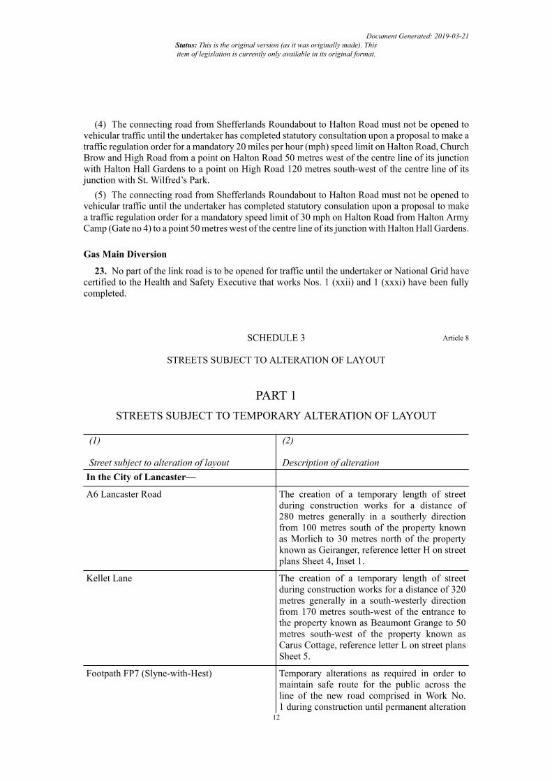
(4) The connecting road from Shefferlands Roundabout to Halton Road must not be opened tovehicular traffic until the undertaker has completed statutory consultation upon a proposal to make atraffic regulation order for a mandatory 20 miles per hour (mph) speed limit on Halton Road, ChurchBrow and High Road from a point on Halton Road 50 metres west of the centre line of its junctionwith Halton Hall Gardens to a point on High Road 120 metres south-west of the centre line of itsjunction with St. Wilfred’s Park.
(5) The connecting road from Shefferlands Roundabout to Halton Road must not be opened tovehicular traffic until the undertaker has completed statutory consulation upon a proposal to makea traffic regulation order for a mandatory speed limit of 30 mph on Halton Road from Halton ArmyCamp (Gate no 4) to a point 50 metres west of the centre line of its junction with Halton Hall Gardens.
Gas Main Diversion
23. No part of the link road is to be opened for traffic until the undertaker or National Grid havecertified to the Health and Safety Executive that works Nos. 1 (xxii) and 1 (xxxi) have been fullycompleted.
SCHEDULE 3 Article 8
STREETS SUBJECT TO ALTERATION OF LAYOUT
PART 1STREETS SUBJECT TO TEMPORARY ALTERATION OF LAYOUT
(1)
Street subject to alteration of layout
(2)
Description of alterationIn the City of Lancaster—
A6 Lancaster Road The creation of a temporary length of streetduring construction works for a distance of280 metres generally in a southerly directionfrom 100 metres south of the property knownas Morlich to 30 metres north of the propertyknown as Geiranger, reference letter H on streetplans Sheet 4, Inset 1.
Kellet Lane The creation of a temporary length of streetduring construction works for a distance of 320metres generally in a south-westerly directionfrom 170 metres south-west of the entrance tothe property known as Beaumont Grange to 50metres south-west of the property known asCarus Cottage, reference letter L on street plansSheet 5.
Footpath FP7 (Slyne-with-Hest) Temporary alterations as required in order tomaintain safe route for the public across theline of the new road comprised in Work No.1 during construction until permanent alteration
12

Document Generated: 2019-03-21Status: This is the original version (as it was originally made). Thisitem of legislation is currently only available in its original format.
(1)
Street subject to alteration of layout
(2)
Description of alterationis available across Beaumont Gate OccupationBridge.
Footpath FP9 (Halton-with-Aughton) Temporary alterations as required to maintainsafe route for the public during constructionworks to adjacent Lune West Bridge.
Footpath FP15 (Quernmore) Temporary alterations as required to maintainsafe route for the public during constructionworks to adjacent Lune West Bridge.
Lune cycle path Temporary alterations as required to maintainsafe route for the public during constructionworks to adjacent Lune West Bridge.
PART 2STREETS SUBJECT TO PERMANENT ALTERATION OF LAYOUT
(1)
Street subject to alteration of layout
(2)
Description of alterationIn the City of Lancaster—
Northgate An increase to the width and alteration of thelevel of the carriageway and adjoining kerbs,footways and verges for a distance of 130 metreson the eastbound approach and 100 metres on thewestbound approach to the junction with A683Lancaster - Morecambe Bypass.
A683 Lancaster - Morecambe Bypass An increase to the width and alteration of thelevel of the carriageway and adjoining kerbs,footway and verges for a distance of 550metres generally in a north-easterly directioncommencing 100 metres south-west of thejunction with Northgate to the junction withA589/A683 Morecambe Road.
Hadrian Road An alteration of the alignment commencing10 metres east from unnamed cul-de-sacoutside No. 2 Hadrian Road to new trafficsignal controlled junction on A683 Lancaster -Morecambe Bypass, reference letter B on streetplans – Sheet 1, Inset 2; a reduction of thecarriageway width of the existing Hadrian Roadfor a distance of 100 metres in a north-easterlydirection from where the new alignment meetsthe present road to form a new exit road fromMcDonald’s Restaurant.
13

Document Generated: 2019-03-21Status: This is the original version (as it was originally made). Thisitem of legislation is currently only available in its original format.
(1)
Street subject to alteration of layout
(2)
Description of alterationLancaster to Morecambe Cycle track An alteration of the alignment to follow the new
alignment of Hadrian Road, reference letter A onthe street plans – Sheet 1, Inset 2.
A589 Morecambe Road Removal of the existing roundabout with theA683 Lancaster – Morecambe Bypass andA683 Morecambe Road and its replacementwith signal controlled cross roads; an increasein width, reconstruction and alteration of thelevel of the kerbs, carriageway and adjoiningfootways, cycle tracks and verges, for a distanceof 250 metres in a westerly direction from thepresent roundabout.
A683 Morecambe Road Removal of the existing roundabout with theA683 Lancaster – Morecambe Bypass andA589 Morecambe Road and its replacementwith signal controlled cross roads; an increasein width, reconstruction and alteration of thelevel of the kerbs, carriageway and adjoiningfootways, cycle tracks and verges, for a distanceof 180 metres in an easterly direction from thepresent roundabout.
B5321 Lancaster Road/Torrisholme Road An increase in width, the provision of cycletrack and an alteration of the alignment andlevel of the carriageway and kerbs and adjoiningfootways and verges for a distance of 190metres initially in an easterly and then south-easterly direction commencing at No. 364Lancaster Road (B5321) to 25 metres north-westof the Torrisholme Road (B5321) entrance toLancaster and Morecambe College.
Barley Cop Lane An increase in width, and alteration of thealignment and level of the existing carriagewayand verges for a distance of 120 metres initiallyin a westerly and then south-westerly directioncommencing 115 metres west of the entranceto Torrisholme Cricket Club to new priorityjunction on the realigned B5321 TorrisholmeRoad, reference letter C on the street plans –Sheet 2, Inset 1.
Powder House Lane An increase in the width, and alteration of thealignment and level of the existing carriagewayand verges for a distance of 420 metres initiallyin an easterly and then southerly direction topass beneath the new Folly Railway Bridge,commencing 220 metres north of its existingjunction with Barley Cop Lane to new priorityjunction on Barley Cop Lane, 325 metres east of
14

Document Generated: 2019-03-21Status: This is the original version (as it was originally made). Thisitem of legislation is currently only available in its original format.
(1)
Street subject to alteration of layout
(2)
Description of alterationthe existing junction, reference letter D on thestreet plans – Sheet 3.
Folly Lane An increase in width, and alteration of thealignment and level of existing carriageway andverges for a distance of 320 metres initially ina south-westerly and then southerly directionto pass beneath the new Folly Railway Bridge,commencing at the property known as Brooksideto 80 metres north of its present junction withBarley Cop Lane, reference letter E on the streetplans – Sheet 3.
A6 Lancaster Road An alteration of the alignment and level ofcarriageway and kerbs, an increase in width ofcarriageway and adjoining footways and verges,and the provision of cycle tracks to cross thenew Lancaster Road bridge over the new roadcomprised in Work No. 1 for a distance of800 metres generally in a southerly directioncommencing at the property known as Lonsdaleto the access track by the pumping station50 metres north of the entrance to BeaumontCollege.
Green Lane An alteration of the alignment and level, anincrease in carriageway and verge width to crossthe new Beaumont Bridge over the new roadcomprised in Work No. 1 for a distance of 300metres initially in a south-westerly and thensouth-easterly direction commencing 830 metressouth from its junction with Bottomdale Road
Kellet Lane An alteration of the alignment and level ofcarriageway to cross new Carus Bridge overthe new road comprised in Work No. 1 fora distance of 490 metres in a south-westerlydirection commencing 50 metres south-west ofthe entrance to the property known as BeaumontGrange to the access to Littledale Mews.
Halton Road An alteration of the alignment and levelof carriageway and kerbs, an increase incarriageway, footway and verge width to passunder new Shefferlands Bridge carrying the newroad comprised in Work No. 1 for a distance of250 metres initially in a westerly and then south-westerly direction commencing at the presentbridge carrying the M6 Motorway over HaltonRoad
15

Document Generated: 2019-03-21Status: This is the original version (as it was originally made). Thisitem of legislation is currently only available in its original format.
(1)
Street subject to alteration of layout
(2)
Description of alterationA683 Caton Road/Lancaster Road An alteration of the alignment and level
of carriageway and kerbs, an increase incarriageway, footway and verge widths, theprovision of new cycle track, the re-siting ofthe existing traffic signal controlled junctionfor M6 Motorway northbound slip roads100 metres east of the present location, thereplacement and remodelling of the existingtraffic signal controlled junction for M6Motorway southbound slip roads at its presentlocation, for a distance of 800 metres initiallyin a westerly and then south-westerly directioncommencing 50 metres east of the entrance to theproperty known as Tarn View to 40 metres south-west of the entrance to the Holiday Inn Hotel.
M6 Motorway northbound entry slip road An alteration of the alignment and level of thecarriageway and verge generally in a northerlydirection for a distance of 450 metres fromShefferlands junction to the point of mergewith the existing M6 Motorway northboundcarriageway, as reference letter AA on thespecial roads plan.
M6 Motorway northbound exit slip road An alteration of the alignment and level of thecarriageway and verge in a northerly directionfor a distance of 530 metres from the pointof diverge from the existing M6 Motorwaynorthbound carriageway to a new junctionwith the exit road from the park and ride,reference letter BB on the special roads plan, andcontinuing in a northerly direction for a further230 metres to a new junction on A683 CatonRoad 100 metres east of the present junctionCaton Road junction.
M6 Motorway southbound entry slip road An alteration of the alignment and level of thecarriageway and verge in a southerly directionfor a distance of 640 metres from A683 CatonRoad to the point of merge with the existing M6Motorway southbound carriageway, referenceletter DD on the special roads plan.
M6 Motorway southbound exit slip road An alteration of the alignment and level of thecarriageway and verge initially in a southerlythen easterly and then northerly direction for adistance of 480 metres from the point of divergefrom the existing M6 Motorway southboundcarriageway to the junction on A683 CatonRoad, reference letter CC on the special roadsplan.
16
Document Generated: 2019-03-21Status: This is the original version (as it was originally made). Thisitem of legislation is currently only available in its original format.
(1)
Street subject to alteration of layout
(2)
Description of alterationFootpath FP7 (Slyne-with-Hest) A re-routing of the public footpath to the
west of its present route onto Beaumont GateOccupation Bridge to cross over the route of thenew road comprised in Work No. 1, referenceletter J on the street plans – Sheet 4, Inset 3.
Footpath FP9 (Halton-with-Aughton) A re-routing of the public footpath to the northof its present route to avoid new north abutmentof Lune West Bridge, reference letter O on thestreet plans – Sheet 7, Inset 1.
SCHEDULE 4 Article 9
STREETS SUBJECT TO STREET WORKS
(1)
Location
(2)
Street subject to street worksCity of Lancaster Northgate
A683 Lancaster - Morecambe Bypass
Hadrian Road
A589 Morecambe Road
A683 Morecambe Road
B5321 Lancaster Road/Torrisholme Road
Barley Cop Lane
Powder House Lane
Folly Lane
A6 Lancaster Road
Green Lane
Kellet Lane
Halton Road
Bottomdale Road
A683 Caton Road/Lancaster Road
M6 Motorway
17

Document Generated: 2019-03-21Status: This is the original version (as it was originally made). Thisitem of legislation is currently only available in its original format.
SCHEDULE 5 Article 11
SPECIAL ROADS
In the City of Lancaster—
1. A road constructed on a route 452 metres in length, starting at a point 331 metres south ofa point on the centreline of Bottomdale Road 104 metres east of its junction with Foundry Laneproceeding in a north-easterly direction to a point 65 metres north of a point on the centre line ofBottomdale Road 5 metres east of the intersection of Bottomdale Road centre line with the centreline of the M6 Motorway, reference letter AA on the special roads plan.
2. A road constructed on a route 532 metres in length, starting at a point 763 metres south of apoint on the centre line of the A683 Caton Road 57 metres west of the intersection of the centre lineof the A683 Caton Road with the centre line of the M6 Motorway proceeding in a northerly directionto a point 247 metres south of a point on the centre line of the A683 Caton Road 111 metres west ofthe intersection of the centre line of the A683 Caton Road with the centre line of the M6 Motorway,reference letter BB on the special roads plan.
3. A road constructed on a route 484 metres in length, starting at a point 234 metres south of apoint on the centre line of the A683 Lancaster Road/Caton Road 34 metres east of the intersectionof the centre line of the A683 Lancaster Road/Caton Road with the centre line of the M6 Motorwayproceeding in a southerly, then easterly, then northerly direction to a point 18 metres south on thecentre line of the A683 Lancaster Road/Caton Road 176 metres east of the intersection of the centreline of the A683 Lancaster Road/Caton Road with the centre line of the M6 Motorway, referenceletter CC on the special roads plan.
4. A road constructed on a route 640 metres in length, starting at a point 16 metres south of apoint on the centre line of the A683 Lancaster Road/Caton Road 194 metres east of the intersectionof the centre line of the A683 Lancaster Road/Caton Road and the centre line of the M6 Motorwayin a southerly and then south-westerly direction to a point 609 metres south of a point on the centreline of the A683 Lancaster Road/Caton Road 12 metres west of the intersection of the centre lineof the A683 Lancaster Road/Caton Road with the centre line of the M6 Motorway, reference letterDD on the special roads plan.
SCHEDULE 6 Article 12
STREETS TO BE STOPPED UP
PART 1STREETS FOR WHICH A SUBSTITUTE IS TO BE PROVIDED
(1)
Area
(2)
Street to be stoppedup
(3)
Extent of stopping up
(4)
New Street to besubstituted
City of Lancaster Lancaster toMorecambe CycleTrack
From a point 40metres north-east ofits junction withthe Lancaster to
Reference Letter Aon the street plans(footpath and cycletrack)
18
Document Generated: 2019-03-21Status: This is the original version (as it was originally made). Thisitem of legislation is currently only available in its original format.
(1)
Area
(2)
Street to be stoppedup
(3)
Extent of stopping up
(4)
New Street to besubstituted
Morecambe CycleTrack in a north-easterly and north-westerly direction for amaximum distance of205 metres
A north-western partwidth of Hadrian Road
From a point 25metres south-westof its junction withthe A683/A589roundabout junctionof the A683 Lancaster- Morecambe Bypassand the A589/A683
Morecambe Roadin a south-westerlydirection for amaximum
distance of 67 metres
Reference Letter B onthe street plans
Barley Cop Lane From its junction withthe B5321 Lancaster
Road/TorrisholmeRoad in an easterlydirection for amaximum distance of73 metres
Reference Letter C onthe street plans
Powder House Lane From its junction withBarley Cop Lane in anortherly direction fora maximum distance of190 metres
Reference Letter D onthe street plans
Folly Lane From a point 76metres north ofits junction withBarley Cop Lane ina north-easterly andnortherly direction fora maximum
distance of 284 metres
Reference Letter E onthe street plans
A6 Lancaster Road From a point 11metres north of thenorthern boundary of
Reference Letters F, Gand I on the street plans
19

Document Generated: 2019-03-21Status: This is the original version (as it was originally made). Thisitem of legislation is currently only available in its original format.
(1)
Area
(2)
Street to be stoppedup
(3)
Extent of stopping up
(4)
New Street to besubstituted
the property knownas Geiranger in anortherly direction fora maximum distance of78 metres
Footpath FP7
(Slyne –with-Hest)
From a point 414metres north ofits junction withGreen Lane in anortherly, westerly andnortherly direction fora maximum distance of147 metres
Reference Letter Jon the street plans(footpath)
Green Lane From a point 83metres south ofHowgill Brook in a
southerly direction fora maximum distanceof 204 metres
Reference Letter K onthe street plans
Kellet Lane From a point 255metres south-west ofits junction with the
entrance to BeaumontGrange in a south-westerly direction fora maximum distanceof 125 metres
Reference Letter M onthe street plans
Halton Road From a point 95metres west of thecentreline of theM6 Motorway in aneasterly direction for amaximum distance of46 metres
Reference Letter N onthe street plans
Footpath FP9
(Halton-with-Aughton)
From a point 53metres south of a pointon the south
boundary of HaltonRoad 44 metres westof the centreline ofthe M6 Motorway ina southerly and south-westerly direction for
Reference Letter O onthe street plans
(footpath)
20

Document Generated: 2019-03-21Status: This is the original version (as it was originally made). Thisitem of legislation is currently only available in its original format.
(1)
Area
(2)
Street to be stoppedup
(3)
Extent of stopping up
(4)
New Street to besubstituted
a maximum distanceof 132 metres
M6 Motorway(northbound)
Northbound entry andexit slip roads fromtheir junction withthe A683 Caton Roadin a northerly andeasterly direction for amaximum distance of225 metres
Reference Letters P, Yand Z on the streetplans
M6 Motorway(southbound)
Southbound entry andexit slip roads fromtheir junction withthe A683 Caton Roadin a southerly andwesterly direction for amaximum distance of254 metres
Reference Letters Wand X on the streetplans
PART 2PRIVATE ACCESSES FOR WHICH A SUBSTITUTE IS TO BE PROVIDED
(1)
Area
(2)
Private access to bestopped up
(3)
Extent of stopping up
(4)
Private Access to besubstituted
City of Lancaster Access X1 on the streetplans
To a track from a point10 metres south of thecentreline
of Hadrian Road 104metres west and south-west of its junctionwith
the A683/A589roundabout junction ofthe A683 Lancaster-Morecambe Bypassand the A589/A683Morecambe Road in a
south-westerlydirection for a distanceof 52 metres
Reference Number 1on the street plans
21

Document Generated: 2019-03-21Status: This is the original version (as it was originally made). Thisitem of legislation is currently only available in its original format.
(1)
Area
(2)
Private access to bestopped up
(3)
Extent of stopping up
(4)
Private Access to besubstituted
Access X2 on the streetplans
To McDonaldsRestaurant from apoint on the north
boundary of HadrianRoad 7 metres west ofits connection to theroundabout junctionof the A683 Lancaster- Morecambe Bypassand the A589/A683Morecambe Road in anortherly direction
Reference Number 2on the street plans
Access X3 on the streetplans
To McDonaldsRestaurant from apoint on the south
boundary of the A589Morecambe Road 80metres north-west ofits connection to theroundabout junctionof the A683 Lancaster- Morecambe Bypassand the A589/A683Morecambe Road
Reference Number 2on the street plans
Access X4 on the streetplans
On the south boundaryof Barley Cop Lane atits junction with theB5321 Lancaster Road/Torrisholme Road overthe width of the access
Reference Number 5on the street plans
Access X5 on the streetplans
On the north boundaryof Barley Cop Lane atits junction with theB5321 Lancaster Road/Torrisholme Road overthe width of the access
Reference Number 6on the street plans
Access X6 on the streetplans
On the north boundaryof Barley Cop Laneat a point 15metres south-east ofits junction with theB5321 Lancaster Road/Torrisholme Road overthe width of the access
Reference Number 8on the street plans
22

Document Generated: 2019-03-21Status: This is the original version (as it was originally made). Thisitem of legislation is currently only available in its original format.
(1)
Area
(2)
Private access to bestopped up
(3)
Extent of stopping up
(4)
Private Access to besubstituted
Access X8 on the streetplans
On the north boundaryof Folly Lane at apoint 80 metres north-west of its junction withBarley Cop Lane overthe width of the access
Reference Number 16on the street plans
Access X9 on the streetplans
On the west boundaryof Folly Lane at apoint 110 metressouth of the southernboundary of theproperty known as
Brookside over thewidth of the access
Reference Number 16on the street plans
Access X11 on thestreet plans
On the west boundaryof the A6 LancasterRoad at a point 70metres south of itsjunction with TurnpikeFold over the width ofthe access
Reference Number 20on the street plans
Access X12 on thestreet plans
On the west boundaryof the A6 LancasterRoad at a point 93metres north of thenorthern boundary ofthe property knownas Geiranger over thewidth of the access
Reference Number 22on the street plans
Access X14 on thestreet plans
On the west boundaryof the A6 LancasterRoad at a point 77metres south of thesouthern boundary ofthe property known asMorlich over the widthof the access
Reference Number 22on the street plans
Access X16 on thestreet plans
On the west boundaryof Green Lane at a point196 metres south ofHowgill Brook over thewidth of the access
Reference Number 28on the street plans
Access X17 on thestreet plans
On the west boundaryof Kellet Lane at
Reference Number 31on the street plans
23

Document Generated: 2019-03-21Status: This is the original version (as it was originally made). Thisitem of legislation is currently only available in its original format.
(1)
Area
(2)
Private access to bestopped up
(3)
Extent of stopping up
(4)
Private Access to besubstituted
a point 334 metressouth-west of itsjunction with theentrance to Beaumont
Grange over the widthof the access
Access X20 on thestreet plans
On the north boundaryof Foundry Lane at apoint 57 metres westof the centreline of theM6 Motorway over thewidth of the access
Reference Number 33on the street plans
Access X21 on thestreet plans
On the south boundaryof Foundry Lane at apoint 31 metres westof the centreline of theM6 Motorway over thewidth of the access
Reference Number 32on the street plans
Access X24 on thestreet plans
On the north boundaryof the A683 CatonRoad/Lancaster Roadat a point 72 metreswest of the centreline ofthe M6 Motorway overthe width of the access
Reference Number 36on the street plans
Access X26 on thestreet plans
On the south boundaryof the A683 CatonRoad/Lancaster Roadat a point 217 metreseast of the centreline ofthe M6 Motorway overthe width of the access
Reference Number 40on the street plans
Access X27 on thestreet plans
To the property knownas Croskells Farm onthe south boundary ofthe A683 Caton Road/Lancaster Road at apoint 52 metres westof the centreline of theM6 Motorway over thewidth of the access
Reference Number 38on the street plans
Access X28 on thestreet plans
On the south boundaryof the A683 CatonRoad/Lancaster Road
Reference Number 37on the street plans
24

Document Generated: 2019-03-21Status: This is the original version (as it was originally made). Thisitem of legislation is currently only available in its original format.
(1)
Area
(2)
Private access to bestopped up
(3)
Extent of stopping up
(4)
Private Access to besubstituted
at a point 126 metreseast of the centreline ofthe M6 Motorway overthe width of the access
Access X30 on thestreet plans
On the south boundaryof the A683 CatonRoad/Lancaster Roadat a point 198 metreseast of the centreline ofthe M6 Motorway overthe width of the access
Reference Number 39on the street plans
Access X31 on thestreet plans
On the south boundaryof the A683 CatonRoad/Lancaster Roadat a point 201 metreseast of the centreline ofthe M6 Motorway overthe width of the access
Reference Number 39on the street plans
Access X32 on thestreet plans
Along GrimeshawLane from a point24 metres north-westof the centreline ofGrimeshaw LaneBridge and 41 metreseast of the centrelineof the M6 Motorwayin a
north-westerlydirection for a distanceof 97 metres
Reference Number 42on the street plans
Access X33 on thestreet plans
On the north boundaryof Grimeshaw Lanefrom a point 88metres north-westof the centrelineof Grimeshaw LaneBridge and 37 metreseast of the centreline ofthe M6 Motorway overthe width of the access
Reference Number 43on the street plans
25

Document Generated: 2019-03-21Status: This is the original version (as it was originally made). Thisitem of legislation is currently only available in its original format.
PART 3STREETS FOR WHICH NO SUBSTITUTE IS TO BE PROVIDED
(1)
Area
(2)
Street to be stopped up
(3)
Extent of stopping upCity of Lancaster Footpath FP12 (Morecambe
and Heysham)From a point 10 metres southof a point on the centrelineof Hadrian Road 92 metreswest and south-west of itsjunction with the A683/A589roundabout junction of theA683 Lancaster - MorecambeBypass and the A589/A683Morecambe Road in a south-westerly direction for a distanceof 52 metres
A northern part width ofthe B5321 Lancaster Road/Torrisholme Road
From a point 66 metres south-east of its junction with RussellDrive in a south-easterlydirection for a maximumdistance of 53 metres
Shefferlands Lane From a point on the northboundary of Halton Road 131metres west of the centrelineof the M6 Motorway ina north-westerly and north-easterly direction for a distanceof 230 metres to the westboundary of the M6 Motorway
Foundry Lane From a point on 311 metressouth-west of its junction withBottomdale Road in an easterlydirection for a distance of 43metres to the west boundary ofthe M6 Motorway
Bottomdale Road(embankments only)
From a point 23 metresnorth-west of the centrelineof the M6 Motorway in anorth-westerly direction for amaximum distance of 45 metres
26

Document Generated: 2019-03-21Status: This is the original version (as it was originally made). Thisitem of legislation is currently only available in its original format.
PART 4PRIVATE ACCESSES FOR WHICH NO SUBSTITUTE IS TO BE PROVIDED
(1)
Area
(2)
Private Access to be stoppedup
(3)
Extent of stopping up
City of Lancaster Access X7 on the street plans On the east boundary of PowderHouse Lane at a point 133metres north of the centre of itscrossroad junction with BarleyCop Lane over the width of theaccess
Access X10 on the street plans On the east boundary of FollyLane at a point 109 metressouth of the southern boundaryof the property known as
Brookside over the width ofthe access
Access X13 on the street plans On the east boundary ofthe A6 Lancaster Road ata point 85 metres north ofthe northern boundary of theproperty known as Geirangerover the width of the access
Access X15 on the street plans On the east boundary ofthe A6 Lancaster Road ata point 52 metres south ofthe southern boundary of theproperty known as Morlichover the width of the access
Access X18 on the street plans On the east boundary ofKellet Lane at a point 301metres southwest of its junctionwith the entrance to BeaumontGrange over the width of theaccess
Access X19 on the street plans On the east boundary of KelletLane at a point 208 metressouth-west of its junction withthe entrance to Beaumont
Grange over the width of theaccess
Access X22 on the street plans On the north boundary ofHalton Road at a point 48metres west of the centreline
27

Document Generated: 2019-03-21Status: This is the original version (as it was originally made). Thisitem of legislation is currently only available in its original format.
(1)
Area
(2)
Private Access to be stoppedup
(3)
Extent of stopping up
of the M6 Motorway over thewidth of the access
Access X23 on the street plans On the north boundary of theA683 Caton Road/LancasterRoad at a point 188 metreswest of the centreline of the M6Motorway over the width of theaccess
Access X25 on the street plans On the north boundary of theA683 Caton Road/LancasterRoad at a point 122 metreseast of the centreline of the M6Motorway over the width of theaccess
Access X29 on the street plans On the south boundary of theA683 Caton Road/LancasterRoad at a point 113 metreswest of the centreline of the M6Motorway over the width of theaccess
SCHEDULE 7 Article 13
TEMPORARY PROHIBITION OR RESTRICTION OF USE OF STREETS
(1)
Area
(2)
Temporary prohibition orrestriction of use of streets
(3)
Extent of temporaryprohibition or restriction ofuse of streets
City of Lancaster Northgate Over a distance of 130metres west and 100 metreseast from its junction withA683 Lancaster – MorecambeBypass, the length shownhatched on street plan Sheet1, as required to ensure thesafety of both the publicand the workforce. Access tofrontages to be maintained at allreasonable times.
A683 Lancaster - MorecambeBypass
Over a distance of 550 metresfrom 100 metres south-westof the junction with Northgate
28

Document Generated: 2019-03-21Status: This is the original version (as it was originally made). Thisitem of legislation is currently only available in its original format.
(1)
Area
(2)
Temporary prohibition orrestriction of use of streets
(3)
Extent of temporaryprohibition or restriction ofuse of streets
north-eastwards to the junctionwith A589/A683 MorecambeRoad, the length shown hatchedon street plan Sheet 1; asrequired to ensure the safetyof both the public and theworkforce.
Lancaster to Morecambe CycleTrack
Short term closure acrossconstruction site as requiredto ensure the safety of boththe public and the workforce,until new permanent route isavailable.
Hadrian Road From its present junction atthe roundabout on A589/A683Morecambe Road to a point 10metres east from unnamed cul-de-sac outside No 2 HadrianRoad, as required to ensure thesafety of both the public and theworkforce, until new permanentroute is available. Access tofrontages to be maintained at allreasonable times.
A589 Morecambe Road Over a distance of 250metres west from the presentroundabout, as the lengthshown hatched on Street Plans,Sheet 1, as required to ensurethe safety of both the publicand the workforce..
Access to frontages to bemaintained at all reasonabletimes. This street is not tobe closed at the same timeas B5321 Lancaster Road/Torrisholme Road.
A683 Morecambe Road Over a distance of 180metres east from the presentroundabout, as the lengthshown hatched on street plan,Sheet 1, as required to ensurethe safety of both the publicand the workforce.
29

Document Generated: 2019-03-21Status: This is the original version (as it was originally made). Thisitem of legislation is currently only available in its original format.
(1)
Area
(2)
Temporary prohibition orrestriction of use of streets
(3)
Extent of temporaryprohibition or restriction ofuse of streets
Access to frontages to bemaintained at all reasonabletimes. This street is not tobe closed at the same timeas B5321 Lancaster Road/Torrisholme Road.
B5321 Lancaster Road/Torrisholme Road
Over a distance of 190 metreseast and south-east fromNo. 364 Lancaster Road(B5321) to 25 metres north-west of the Torrisholme Road(B5321) entrance to Lancasterand Morecambe College, asrequired to ensure the safetyof both the public and theworkforce.
Access to frontages to bemaintained at all reasonabletimes. This street is not to beclosed at the same time asA589/A683 Morecambe Road.
Barley Cop Lane From its junction with B5321Lancaster Road/TorrisholmeRoad and Powder House Lane,as required to ensure thesafety of both the publicand the workforce. Access tofrontages to be maintained at allreasonable times.
Powder House Lane From its junction with BarleyCop Lane to its junction withHasty Brow Road, as requiredto ensure the safety of boththe public and the workforce.Access to frontages to bemaintained at all reasonabletimes.
Folly Lane North and west from itsjunction with Barley Cop Lanefor a distance of 370 metres,as required to ensure thesafety of both the publicand the workforce. Access to
30
Document Generated: 2019-03-21Status: This is the original version (as it was originally made). Thisitem of legislation is currently only available in its original format.
(1)
Area
(2)
Temporary prohibition orrestriction of use of streets
(3)
Extent of temporaryprohibition or restriction ofuse of streets
frontages to be maintained at allreasonable times.
A6 Lancaster Road Over a distance of 800 metressouthwards from the propertyknown as Lonsdale to theaccess track by the pumpingstation 50 metres north of theentrance to Beaumont College,the length shown hatched onstreet plan, Sheet 4, as requiredto ensure the safety of boththe public and the workforce.Access to frontages to bemaintained at all reasonabletimes.
Green Lane From its junction withBottomdale Road to thejunction at Beaumont Hallbridge, as required to ensurethe safety of both the publicand the workforce. Access tofrontages to be maintained at allreasonable times.
Kellet Lane From its junction withBottomdale Road to thejunction with Halton Road,as required to ensure thesafety of both the public andthe workforce. Access tofrontages to be maintained atall reasonable times.
This street is not to be closedat the same time as BottomdaleRoad and Halton Road.
Halton Road From its junction withKellet Lane to the junctionwith Church Brow, Halton,as required to ensure thesafety of both the public andthe workforce. Access tofrontages to be maintained atall reasonable times.
31

Document Generated: 2019-03-21Status: This is the original version (as it was originally made). Thisitem of legislation is currently only available in its original format.
(1)
Area
(2)
Temporary prohibition orrestriction of use of streets
(3)
Extent of temporaryprohibition or restriction ofuse of streets
This street is not to be closedat the same time as Kellet Laneand Bottomdale Road.
Bottomdale Road From its junction withFoundry Lane to the junctionwith Church Brow, Halton,as required to ensure thesafety of both the public andthe workforce. Access tofrontages to be maintained atall reasonable times.
This street is not to be closedat the same time as Kellet Laneand Halton Road.
A683 Caton Road/LancasterRoad
Over a distance of 800 metreswest and then south-west froma point 50 metres east ofthe entrance to the propertyknown as Tarn View to apoint 40 metres south-west ofthe entrance to the HolidayInn Hotel, the length shownhatched on street plan Sheet8 as required to ensure safeoperations for both the publicand the workforce. Access tofrontages to be maintained at allreasonable times.
M6 Motorway Overnight closure betweenjunctions 33 & 34 to allowerection of new sign gantriesacross the motorway asrequired.
Footpath FP7 (Slyne –with-Hest)
Short term closure acrossconstruction site as requiredto ensure the safety of boththe public and the workforcewhen alternative safe route notfeasible, until new permanentroute is available.
Footpath FP9 (Halton-with-Aughton)
Short term closure acrossconstruction site as requiredduring construction of the LuneWest Bridge (Work No. 1
32

Document Generated: 2019-03-21Status: This is the original version (as it was originally made). Thisitem of legislation is currently only available in its original format.
(1)
Area
(2)
Temporary prohibition orrestriction of use of streets
(3)
Extent of temporaryprohibition or restriction ofuse of streets
(xxvi)) to ensure the safetyof both the public and theworkforce when alternativesafe route for pedestrians notfeasible, until new permanentroute is available.
Footpath FP15 (Quernmore) Short term closure acrossconstruction site as requiredduring construction of the LuneWest Bridge (Work No. 1(xxvi)) to ensure the safetyof both the public and theworkforce when alternativesafe route for pedestrians notfeasible.
Lune cycle path Short term closure acrossconstruction site as requiredduring construction of the LuneWest Bridge (Work No. 1(xxvi)) to ensure the safetyof both the public and theworkforce when alternativesafe route for pedestrians notfeasible.
SCHEDULE 8 Article 14
ACCESS TO AND FROM WORKS
PART 1PUBLIC ACCESS TO AND FROM WORKS
(1)
Area
(2)
Description of accessCity of Lancaster New access north-east from College Junction on
A589/A683 – street plans Reference a
Footpath and cycle track west off B5321Torrisholme Road – street plans Reference b
33

Document Generated: 2019-03-21Status: This is the original version (as it was originally made). Thisitem of legislation is currently only available in its original format.
(1)
Area
(2)
Description of accessFootpath and cycle track east off B5321Lancaster Road - within highway authority land– street plans Reference c
Footpath west off Powder House Lane - withinhighway authority land – street plans Referenced
Footpath west off Powder House Lane - withinhighway authority land – street plans Referencee
Footpath and cycle track east off Folly Lane- within highway authority land – street plansReference f
Footpath and cycle track west off LancasterCanal towpath - within highway authority land –street plans Reference g
New access west off A6 Lancaster Road -Beaumont Link – street plans Reference h
Footpath and cycle track south-west off A6Lancaster Road - within highway authority land– street plans Reference i
Footpath and bridleway east off Green Lane- within highway authority land – street plansReference j
Footpath and cycle track north-west off KelletLane - within highway authority land – streetplans Reference k
New access north off Halton Road – street plansReference l
Footpath, cycle track and bridleway north-westoff Halton Road - within highway authority land– street plans Reference m
New accesses north from Croskells junction,Caton Road – street plans Reference n
Footpath and cycle track north off Caton Road- within highway authority land – street plansReference o
Footpath and cycle track south off Lune cyclepath - within highway authority land – streetplans Reference p
New accesses south from Croskells junction,Caton Road – street plans Reference q
34

Document Generated: 2019-03-21Status: This is the original version (as it was originally made). Thisitem of legislation is currently only available in its original format.
(1)
Area
(2)
Description of accessFootpath and cycle track north off Barley CopLane - within highway authority land – streetplans Reference r
PART 2PRIVATE ACCESS TO AND FROM WORKS
(1)
Area
(2)
Description of accessCity of Lancaster New private means of access – street plans Reference
Number 3
New private means of access – street plans ReferenceNumber 4
New private means of access – street plans ReferenceNumber 7
New private means of access – street plans ReferenceNumber 9
New private means of access – street plans ReferenceNumber 10
New private means of access – street plans ReferenceNumber 11
New private means of access – street plans ReferenceNumber 12
New private means of access – street plans ReferenceNumber 13
New private means of access – street plans ReferenceNumber 14
New private means of access – street plans ReferenceNumber 15
New private means of access – street plans ReferenceNumber 17
New private means of access – street plans ReferenceNumber 18
New private means of access – street plans ReferenceNumber 19
New private means of access – street plans ReferenceNumber 21
35

Document Generated: 2019-03-21Status: This is the original version (as it was originally made). Thisitem of legislation is currently only available in its original format.
(1)
Area
(2)
Description of accessNew private means of access – street plans ReferenceNumber 23
New private means of access – street plans ReferenceNumber 24
New private means of access – street plans ReferenceNumber 25
New private means of access – street plans ReferenceNumber 26
New private means of access – street plans ReferenceNumber 27
New private means of access – street plans ReferenceNumber 29
New private means of access – street plans ReferenceNumber 30
New private means of access – street plans ReferenceNumber 34
New private means of access – street plans ReferenceNumber 35
New private means of access – street plans ReferenceNumber 41
SCHEDULE 9 Article 22(2)
LAND IN WHICH ONLY NEW RIGHTS ETC. MAY BE ACQUIRED
(1)
Number of land shown on land plans
(2)
Purpose for which rights over the land maybe acquired
41 The right of access and the right to carry out andmaintain landscaping works for 20 years.
42, 60 and 61 The right of access, the right to construct, keep,and maintain, and rights for working spaces,in relation to the following works: boundaryfences and embankments; the carrying out, andmaintenance for 20 years only, of landscapingworks; a new access track; wingwalls; aretaining wall; the installation of drainage pipesover land and playing fields forming part ofpremises known as Lancaster and MorecambeCollege.
36

Document Generated: 2019-03-21Status: This is the original version (as it was originally made). Thisitem of legislation is currently only available in its original format.
(1)
Number of land shown on land plans
(2)
Purpose for which rights over the land maybe acquired
49 Right of access to neighbouring land.
52 The right to construct, keep, and maintain, andrights for working spaces, in relation to worksto erect and maintain boundary fences andembankments; to install and maintain drainagepipes; to construct and maintain wingwallsand foundations; to construct and maintain aretaining wall and foundations; the carryingout, and maintenance for 20 years only, oflandscaping works.
56 The right to construct, keep and maintainretaining wall over land to the rear, southand north of premises known as Meter House(water), including related rights for workingspaces and access.
65a The right to construct and maintain an openwatercourse along the north-west foot of theHeysham to M6 Link Road embankment, southof Torrisholme Road, including related rights forworking spaces and access.
65b The right to construct and maintain an openwatercourse along the north-west foot of theHeysham to M6 Link Road embankment, andthe right to divert across this land and maintaintwo water mains south of Torrisholme Road,including related rights for working spaces andaccess.
65c The right to construct and maintain a jointingpit for high voltage electricity cables and theright to divert across this land and maintaintwo water mains south of Torrisholme Road,including related rights for working spaces andaccess.
65d The right to divert across this land and maintaintwo water mains south of Torrisholme Road,including related rights for working spaces andaccess.
69 The right of access, and to construct, keepand maintain, and rights for working spaces,relating to the installation of drainage pipes andconstruction of a drainage headwall on adjacentland.
94, 95 and 96 The right to construct, keep and maintain abridge to carry the Heysham to M6 Link Road
37

Document Generated: 2019-03-21Status: This is the original version (as it was originally made). Thisitem of legislation is currently only available in its original format.
(1)
Number of land shown on land plans
(2)
Purpose for which rights over the land maybe acquired
and earthworks for Folly Lane and PowderHouse Lane diversions; related rights for accessand working spaces, including the right to swingthe jib of a crane, loaded or unloaded, inconnection with development on adjoining landthrough the air-space over land and railwaytrack.
108,110 and 112 The right to construct, keep and maintain a newbridge to carry the Heysham to M6 Link Roadand sheet pile canal protection, related rights foraccess and working spaces, including the right toswing the jib of a crane, loaded or unloaded, inconnection with development on adjoining landthrough the air-space over land.
120a and 121a Rights to construct, keep and maintainapparatus, to create working spaces and accesswith or without vehicles, plant and machinery;to construct and maintain a temporary diversionof Lancaster Road (A6) and to regrade land uponremoval of temporary diversion.
130, 132, 135, 136, 175 and 176 Rights of access, and to construct, keep andmaintain, and rights for working spaces andaccess, relating to new bridges, including theright to swing the jib of a crane, loadedor unloaded, in connection with developmenton adjoining land through the air-space overland; for inspection and maintenance ofHabitat Creation Area; to maintain culvertedwatercourse and headwall over grassland,pasture land and cattle grid forming part ofBeaumont Gate Farm, including related rightsfor working spaces and access.
139, 142 to 172 inclusive The right of access, to construct, keep andmaintain Slynedales culvert including manholes,headwall and outfall cascade, and related rightsfor working spaces and access across grasslandand pasture land forming part of Beaumont GateFarm, part of Howgill Brook and part of publicfootpath (FP7) situated east of Lancaster Road(A6), below the Lancaster Canal, along MossPlace, Woodlands Road and Halton Road andOpen Space off Halton Road.
182, 184, 185 and 186 The right to carry out, and maintain for 20 years,landscaping works.
38

Document Generated: 2019-03-21Status: This is the original version (as it was originally made). Thisitem of legislation is currently only available in its original format.
(1)
Number of land shown on land plans
(2)
Purpose for which rights over the land maybe acquired
192b, 193, 194 and 196 The right to construct, keep and maintain highpressure gas pipelines and medium pressure gasmains for National Grid in the Shefferlands area,and related rights for working spaces and access.
203 Right to install and maintain telecommunicationducts over land and access track.
220 The right to construct, keep and maintaindrainage pipes and manholes to connect intoexisting Highways Agency drainage systemincluding related rights for working spaces andaccess over land, verge and embankment, exceptthose held by or on behalf of the Crown.
222 The right to construct, keep and maintain anew bridge to carry the Heysham to M6 LinkRoad, and related rights for working spaces andaccess including the right to swing the jib of acrane, loaded or unloaded, in connection withdevelopment on adjoining land through the air-space over land and the River Lune.
228 The right to construct, keep and maintain a newbridge to carry the Heysham to M6 Link Road,a reshaped existing cutting slope, a footpathand cycle track, and a culvert; related rights forworking spaces and access, including the right toswing the jib of a crane, loaded or unloaded, inconnection with development on adjoining landthrough the air-space over land (former railway),path, embankments and the Lune cycle path.
238 and 239 The right of access, and to maintain an existingculvert in, on, over or under land, car park,landscaped areas forming part of hotel premisesknown as Holiday Inn Lancaster and footpath(former railway), embankments and the Lunecycle path.
263 The right to construct, keep and maintainretaining wall forming part of Hudson’s farm;related rights for working spaces and access.
271 The right to carry out, and maintain for 20 years,landscaping works.
275, 277 and 278 The right to carry out, and maintain for 20 years,landscaping works.
39

Document Generated: 2019-03-21Status: This is the original version (as it was originally made). Thisitem of legislation is currently only available in its original format.
SCHEDULE 10 Article 22(3)
MODIFICATION OF COMPENSATION AND COMPULSORYPURCHASE ENACTMENTS FOR CREATION OF NEW RIGHTS
Compensation enactments
1. The enactments for the time being in force with respect to compensation for the compulsorypurchase of land apply, with the necessary modifications as respects compensation, in the case of acompulsory acquisition under this Order of a right by the creation of a new right as they apply asrespects compensation on the compulsory purchase of land and interests in land.
2.—(1) Without limitation on the scope of paragraph 1, the Land Compensation Act 1973(2) haseffect subject to the modifications set out in sub-paragraphs (2) and (3).
(2) In section 44(1) (compensation for injurious affection), as it applies to compensation forinjurious affection under section 7 of the 1965 Act as substituted by paragraph 4—
(a) for the words “land is acquired or taken” there are substituted the words “a right over landis purchased from”; and
(b) for the words “acquired or taken from him” there are substituted the words “over whichthe right is exercisable”.
(3) In section 58(1) (determination of material detriment where part of house etc. proposed forcompulsory acquisition), as it applies to determinations under section 8 of the 1965 Act as substitutedby paragraph 5—
(a) for the word “part” in paragraphs (a) and (b) there are substituted the words “a right overland consisting”;
(b) for the word “severance” there are substituted the words “right over the whole of the house,building or manufactory or of the house and the park or garden”;
(c) for the words “part proposed” there are substituted the words “right proposed”; and(d) for the words “part is” there are substituted the words “right is”.
Application of the 1965 Act
3.—(1) The 1965 Act has effect with the modifications necessary to make it apply to thecompulsory acquisition under this Order of a right by the creation of a new right as it applies to thecompulsory acquisition under this Order of land, so that, in appropriate contexts, references in thatAct to land are read (according to the requirements of the particular context) as referring to, or asincluding references to—
(a) the right acquired or to be acquired; or(b) the land over which the right is or is to be exercisable.
(2) Without limitation on the scope of sub-paragraph (1), Part 1 of the 1965 Act applies in relationto the compulsory acquisition under this Order of a right by the creation of a new right with themodifications specified in the following provisions of this Schedule.
4. For section 7 of the 1965 Act (measure of compensation in case of severance) there issubstituted the following section—
“7. In assessing the compensation to be paid by the acquiring authority under this Act,regard must be had not only to the extent (if any) to which the value of the land over which
(2) 1973 c. 26.40

Document Generated: 2019-03-21Status: This is the original version (as it was originally made). Thisitem of legislation is currently only available in its original format.
the right is to be acquired is depreciated by the acquisition of the right but also to the damage(if any) to be sustained by the owner of the land by reason of its severance from other landof the owner, or injuriously affecting that other land by the exercise of the powers conferredby this or the special Act.”.
5. For section 8 of the 1965 Act (provisions as to divided land) there is substituted the followingsection—
“8.—(1) Where in consequence of the service on a person under section 5 of this Act ofa notice to treat in respect of a right over land consisting of a house, building or manufactoryor of a park or garden belonging to a house (“the relevant land”)—
(a) a question of disputed compensation in respect of the purchase of the rightwould apart from this section fall to be determined by the Upper Tribunal (“thetribunal”); and
(b) before the tribunal has determined that question the tribunal is satisfied that theperson has an interest in the whole of the relevant land and is able and willingto sell that land and—
(i) where that land consists of a house, building or manufactory, that the rightcannot be purchased without material detriment to that land; or
(ii) where that land consists of such a park or garden, that the right cannot bepurchased without seriously affecting the amenity or convenience of thehouse to which that land belongs,
the Lancashire County Council (Torrisholme to the M6 Link (A683 Completion of Heyshamto M6 Link Road)) Order 2013(3) (“the Order”), in relation to that person, ceases toauthorise the purchase of the right and is deemed to authorise the purchase of that person’sinterest in the whole of the relevant land including, where the land consists of such a parkor garden, the house to which it belongs, and the notice is deemed to have been served inrespect of that interest on such date as the tribunal directs.
(2) Any question as to the extent of the land in which the Order is deemed to authorisethe purchase of an interest by virtue of subsection (1) of this section is to be determinedby the tribunal.
(3) Where in consequence of a determination of the tribunal that it is satisfied asmentioned in subsection (1) of this section the Order is deemed by virtue of that subsectionto authorise the purchase of an interest in land, the acquiring authority may, at any timewithin the period of 6 weeks beginning with the date of the determination, withdraw thenotice to treat in consequence of which the determination was made; but nothing in thissubsection prejudices any other power of the authority to withdraw the notice.”.
6. The following provisions of the 1965 Act (which state the effect of a deed poll executed invarious circumstances where there is no conveyance by persons with interests in the land), that isto say—
(a) section 9(4) (failure by owners to convey);(b) paragraph 10(3) of Schedule 1 (owners under incapacity);(c) paragraph 2(3) of Schedule 2 (absent and untraced owners); and(d) paragraphs 2(3) and 7(2) of Schedule 4 (common land),
are modified so as to secure that, as against persons with interests in the land which are expressedto be overridden by the deed, the right which is to be compulsorily acquired is vested absolutely inthe acquiring authority.
(3) S.I. 2013/675.41

Document Generated: 2019-03-21Status: This is the original version (as it was originally made). Thisitem of legislation is currently only available in its original format.
7. Section 11 of the 1965 Act (powers of entry) is modified so as to secure that, as from thedate on which the acquiring authority has served notice to treat in respect of any right it has power,exercisable in equivalent circumstances and subject to equivalent conditions, to enter for the purposeof exercising that right (which is deemed for this purpose to have been created on the date of serviceof the notice); and sections 12 (penalty for unauthorised entry) and 13 (entry on warrant in the eventof obstruction) of the 1965 Act are modified correspondingly.
8. Section 20 of the 1965 Act (protection for interests of tenants at will, etc.) applies with themodifications necessary to secure that persons with such interests in land as are mentioned in thatsection are compensated in a manner corresponding to that in which they would be compensated ona compulsory acquisition under this Order of that land, but taking into account only the extent (ifany) of such interference with such an interest as is actually caused, or likely to be caused, by theexercise of the right in question.
9. Section 22 of the 1965 Act (interests omitted from purchase) is modified so as to enable theacquiring authority, in circumstances corresponding to those referred to in that section, to continueto be entitled to exercise the right acquired, subject to compliance with that section as respectscompensation.
SCHEDULE 11 Article 28
LAND OF WHICH TEMPORARY POSSESSION MAY BE TAKEN
(1)
Location
(2)
Number of landshown on land plans
(3)
Purpose forwhich temporarypossession may betaken
(4)
Relevant part ofthe authoriseddevelopment
City of Lancaster 8 Temporary workingarea to constructproperty boundary
Work No. 1(iv)
9 Temporary workingarea to strengthenexisting bridge
Work No. 1(iii)
37 Temporary workingarea to provide newaccess off MorecambeRoad (A589); newegress onto aroad connecting toHadrian Road andto reconfigure internalcirculation and carparking layout
Work Nos. 1(v) and(vii)
38 Temporary workingarea to construct andimprove the existingaccess
Work No. 7
42
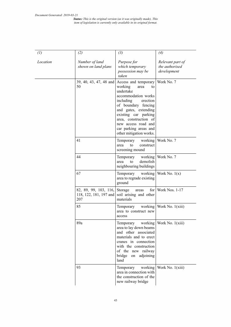
Document Generated: 2019-03-21Status: This is the original version (as it was originally made). Thisitem of legislation is currently only available in its original format.
(1)
Location
(2)
Number of landshown on land plans
(3)
Purpose forwhich temporarypossession may betaken
(4)
Relevant part ofthe authoriseddevelopment
39, 40, 43, 47, 48 and50
Access and temporaryworking area toundertakeaccommodation worksincluding erectionof boundary fencingand gates, extendingexisting car parkingarea, construction ofnew access road andcar parking areas andother mitigation works.
Work No. 7
41 Temporary workingarea to constructscreening mound
Work No. 7
44 Temporary workingarea to demolishneighbouring buildings
Work No. 7
67 Temporary workingarea to regrade existingground
Work No. 1(x)
82, 89, 99, 103, 116,118, 122, 181, 197 and207
Storage areas forsoil arising and othermaterials
Work Nos. 1-17
85 Temporary workingarea to construct newaccess
Work No. 1(xiii)
89a Temporary workingarea to lay down beamsand other associatedmaterials and to erectcranes in connectionwith the constructionof the new railwaybridge on adjoiningland
Work No. 1(xiii)
93 Temporary workingarea in connection withthe construction of thenew railway bridge
Work No. 1(xiii)
43

Document Generated: 2019-03-21Status: This is the original version (as it was originally made). Thisitem of legislation is currently only available in its original format.
(1)
Location
(2)
Number of landshown on land plans
(3)
Purpose forwhich temporarypossession may betaken
(4)
Relevant part ofthe authoriseddevelopment
100 Temporary workingarea to construct newaccess
Work No. 1(xiii)
102, 104, 105, 106 ,107, 113 and 115
Temporary workingarea in connection withthe construction ofthe new canal bridgeincluding constructionand maintenance ofa temporary bridgeover the canal andconnection of newfootpath and cycletrack to canal towpath
Work Nos. 1(xiv) and(xv)
120 Temporary workingarea to construct andmaintain temporarydiversion of LancasterRoad (A6) and toregrade land uponremoval of temporarydiversion
Work No. 1(xvii)
121 Storage areas for soilarising and to regradeland upon removal soilarising
Work No. 1(xvii)
125, 127 and 128 Temporary workingarea on part ofBeaumont Gate Farmto regrade existingground to new levelof Lancaster Road(A6) and to improveexisting accesses offthe stopped up sectionof Lancaster Road (A6)
Work No. 1(xvii)
129, 131, 133 and 134 Temporary workingarea in connectionwith the constructionof the new farmoccupation bridge andaccess track, includingregrading land
Work No. 9
44

Document Generated: 2019-03-21Status: This is the original version (as it was originally made). Thisitem of legislation is currently only available in its original format.
(1)
Location
(2)
Number of landshown on land plans
(3)
Purpose forwhich temporarypossession may betaken
(4)
Relevant part ofthe authoriseddevelopment
139, 142 to 173 Temporary workingarea
Work No. 5
140 and 141 Temporary right ofaccess
Work No. 5
180 Temporary workingarea to regrade existingground to new level ofGreen Lane
Work No. 1(xix)
182, 184, 185 and 186 Temporary workingarea to regradeand divert watercourseknown as How GillBrook
Work Nos. 1(xx) and 4
183, 189, 190, 192 and192a
Temporary workingarea to construct andmaintain temporarydiversion of KelletLane and to regradeexisting ground to newlevel of Kellet Lane
Work No. 1(xxi)
192b, 193, 194 and 196 temporary workingarea
Work No. 1(xxii)
211 and 212 Temporary workingarea to regradewatercourse known asCote Beck
Work No. 1(xxiii)
217 Temporary workingarea to construct andreconfigure existingmain access andentrance gate to HaltonTraining Camp offHalton Road
Work No. 8
218 Compounds andancillary features
Work Nos. 1-17
227, 231, 232, 234 and236
Temporary workingarea to constructthe new bridge overthe River Lune, tolay down beamsand other associatedmaterials, erect cranes
Work No. 1(xxvi)
45

Document Generated: 2019-03-21Status: This is the original version (as it was originally made). Thisitem of legislation is currently only available in its original format.
(1)
Location
(2)
Number of landshown on land plans
(3)
Purpose forwhich temporarypossession may betaken
(4)
Relevant part ofthe authoriseddevelopment
and to construct afootpath and cycletrack forming partof the Lancaster toCaton Cycle Track –River Lune Cycleway(No. 69) and RiverLune Millennium Path
240 Temporary workingarea to construct andimprove the existingaccess to the hotelknown as Holiday InnLancaster
Work No. 1(xxix)
241 Temporary right ofaccess along accessway to the west ofthe hotel known asHoliday Inn Lancaster
Work Nos. 1(xxvi) and(xxix)
242 Temporary right ofaccess along land(former railway),public footpath(No. 15) and theLancaster to CatonCycle Track –River Lune Cycleway(No. 69) and RiverLune Millennium Path,Lune Valley Ramble,the Caton Trail andHalton Circular Walk
Work No. 1(xxix)
261 Temporary workingarea to construct accesstrack and fence forthe premises known asCuckoo Farm or RidgeFarm
Work No. 1(xxviii)
262, 264 and 266 Temporary workingarea to erect retainingwall and to constructnew access off CatonRoad (A683), andto regrade existing
Work Nos. 1(xxviii)and (xxxi)
46

Document Generated: 2019-03-21Status: This is the original version (as it was originally made). Thisitem of legislation is currently only available in its original format.
(1)
Location
(2)
Number of landshown on land plans
(3)
Purpose forwhich temporarypossession may betaken
(4)
Relevant part ofthe authoriseddevelopment
ground, for theproperty known asHudson’s Farm
267, 268 and 269 Temporary workingarea to improve theexisting access offCaton Road (A683) forthe properties knownas Tarn View and ThreeAcres
Work No. 1(xxx)
271 Temporary workingarea to construct accesstrack, regrade existingground, and installdrainage
Work No. 1(xxx)
275, 277 and 278 Temporary workingarea to realignGrimeshaw Lane
Work No. 1(xxxiv)
280, 283, 285 and 287 Temporary workingarea to constructfoundations and erectnew sign gantry
Work No. 1(xxxii)
SCHEDULE 12 Article 35
TREES SUBJECT TO TREE PRESERVATION ORDERS
(1)
Type of tree
(2)
Number of tree on land plan
(3)
Work to be carried outSessile Oak
(Quercus petraea)
TPO -1
(Barley Cop Lane – southverge 10 metres west ofjunction with Powder HouseLane)
Lopping overhanging branchesto prevent damage byconstruction traffic
Common Ash
(Fraxinusexcelsior)
TPO -2
(Powder House Lane – westverge 50 metres south of
Lopping overhanging branchesto prevent damage byconstruction traffic
47

Document Generated: 2019-03-21Status: This is the original version (as it was originally made). Thisitem of legislation is currently only available in its original format.
(1)
Type of tree
(2)
Number of tree on land plan
(3)
Work to be carried outjunction with Barley CopLane)
Sycamore
(Acer pseudoplatanus)
TPO -3
(Powder House Lane – westverge 90 metres south ofjunction with Barley CopLane)
Lopping overhanging branchesto prevent damage byconstruction traffic
Sycamore
(Acer pseudoplatanus)
TPO 4
(Powder House Lane – westverge 100 metres south ofjunction with Barley CopLane)
Lopping overhanging branchesto prevent damage byconstruction traffic
Sycamore
(Acer pseudoplatanus)
TPO -5
(Powder House Lane – westverge 110 metres south ofjunction with Barley CopLane)
Lopping overhanging branchesto prevent damage byconstruction traffic
SCHEDULE 13 Article 39
FOR THE PROTECTION OF THE CANAL & RIVER TRUST
Interpretation
1.—(1) For the protection of the Trust the following provisions of this Schedule, unless otherwiseagreed in writing between the undertaker and the Trust, have effect.
(2) In this Schedule“Authorised works” means the construction of any works authorised by this Order;“construction”, in relation to any specified work or protective work, includes–(a) the execution and placing of that work; and(b) any relaying, renewal, or maintenance of that work as may be carried out during the
period of 12 months from the completion of that work;and “construct” and “constructed” have corresponding meanings;“detriment” means any damage to the waterway or any other property of the Trust and, withoutlimitation on the scope of that meaning, includes—(i) any obstruction of, or interference with, or hindrance or danger to, navigation or to any
use of the waterway (including towing paths);(ii) the erosion of the bed or banks of the waterway, or the impairment of the stability of any
works, lands or premises forming part of the waterway;
48

Document Generated: 2019-03-21Status: This is the original version (as it was originally made). Thisitem of legislation is currently only available in its original format.
(iii) the deposit of materials or the siltation of the waterway so as to materially damage thewaterway;
(iv) the pollution of the waterway;(v) any significant alteration in the water level of the waterway, or significant interference
with the supply of water to it, or drainage of water from it;(vi) any material harm to the ecology of the waterway (including any material adverse impact
on any site of special scientific interest comprised in the Trust’s network); and(vii) (any interference with the exercise by any person of rights over the Trust’s network;“the engineer” means an engineer appointed by the Trust for the purpose in question;“plans” includes sections, designs, drawings, specifications, soil reports, calculations,descriptions (including descriptions of methods of construction) and programmes;“practical completion” means practical completion of all of the specified work notwithstandingthat items which would ordinarily be considered snagging items remain outstanding, and theexpression “practically complete” and “practically completed” are to be construed accordingly“protective work” means a work constructed under paragraph 6(3)(a);“specified work” means so much of any of the authorised works as is situated upon, across,under, over or within 15 metres of, or may in any way affect the waterway;“towing path” means the towing path forming part of the waterway;“the Trust” means the Canal & River Trust;“the Trust’s network” means the Trust’s network of waterways;“the waterway” means the Lancaster Canal, and includes any works, lands or premisesbelonging to the Trust, or under its management or control, and held or used by the Trust inconnection with that canal.
Powers requiring Canal & River Trust consent
2.—(1) The undertaker must not under the powers conferred by this Order acquire compulsorilyany land of the Trust or any easement or other right over such land, or use any such land, unless suchacquisition or use is with the consent of the Trust.
(2) The undertaker must not in the exercise of the powers conferred by this Order obstruct orinterfere with pedestrian or vehicular access to the waterway unless such obstruction or interferencewith such access is with the consent of the Trust.
(3) The undertaker must not exercise the powers conferred by article 13 (temporary prohibitionor restriction of use of streets) in relation to any way over land comprised in the waterway unlesssuch exercise is with the consent of the Trust.
(4) Nothing in article 18 (temporary closure of, and works in, the canal) authorises the undertaker—
(a) to discharge any water directly or indirectly into the waterway; or(b) to carry out any works to, or make any opening in, or otherwise interfere with, the
waterway (including its banks and bed),except with the consent of the Trust and on terms that the Trust may reasonably require, and inaccordance with plans approved by, and under the supervision (if given) of, the engineer.
(5) The undertaker must not exercise any power conferred by this Order in such a way as tointerfere with the supply of water to or the drainage of water from the waterway unless such exerciseis with the consent of the Trust.
49

Document Generated: 2019-03-21Status: This is the original version (as it was originally made). Thisitem of legislation is currently only available in its original format.
(6) The undertaker must not exercise the powers conferred by article 18, or article 19 (authorityto survey and investigate land) or section 11(3) of the 1965 Act (power of entry for surveying land),in relation to the waterway unless such exercise is with the consent of the Trust.
(7) The undertaker must not exercise the powers conferred by section 271 of the Town andCountry Planning Act 1990, in respect of any right of access to the waterway, unless such exerciseis with the consent of the Trust.
(8) The consent of the Trust under sub-paragraphs (1) to (7) and the approval of plans under sub-paragraph (4) must not be unreasonably withheld or delayed but may be given subject to reasonableterms and conditions which in the case of article 6 (discharge of water) may include conditions—
(a) specifying the maximum volume of water which may be discharged in any period; and(b) authorising the Trust on giving reasonable notice (except in an emergency, when the Trust
may require immediate suspension) to the undertaker to require the undertaker to suspendthe discharge of water or reduce the flow of water where this is necessary by reason ofany operational or environmental requirement of the Trust.
Vehicles, plant and machinery
3. The undertaker must not use any land or property of the Trust forming part of the waterway forthe passage or siting of vehicles, plant or machinery employed in the construction of the specifiedworks other than—
(a) with the consent in writing of the engineer whose consent must not be unreasonablywithheld; and
(b) subject to compliance with such reasonable requirements as the engineer may from timeto time specify—
(i) for the prevention of detriment; or(ii) in order to avoid or reduce any inconvenience to the Trust, its officers and agents
and all other persons lawfully on such land or property,
but nothing in this paragraph applies in relation to anything done in accordance with any approvalgiven by the Trust under paragraph 7.
Fencing
4. Where so required by the engineer the undertaker must to the reasonable satisfaction of theengineer fence off a specified work or a protective work or take such other steps as the engineer mayreasonably require to be taken for the purpose of separating a specified work or a protective workfrom the waterway, whether on a temporary or permanent basis or both.
Survey of waterway
5.—(1) Before the commencement of the initial construction of any part of the specified worksand again following practical completion of the specified works the undertaker must appoint aqualified engineer (“the surveyor”) , to be approved by the Trust and must bear the reasonable costof the carrying out by the surveyor of a topographical survey (including a dip-survey to measurethe depth of the waterway) (“the survey”) of so much of the waterway and of any land and existingworks of the undertaker which may provide support for the waterway as will or may be affectedby the specified works.
(2) For the purposes of the survey the undertaker must—
50

Document Generated: 2019-03-21Status: This is the original version (as it was originally made). Thisitem of legislation is currently only available in its original format.
(a) on being given reasonable notice (except in case of emergency, when immediate accessmust be afforded) afford reasonable facilities to the surveyor for access to the site of thespecified works and to any land and to existing works of the undertaker which may providesupport for the waterway as will or may be affected by the specified works; and
(b) supply the surveyor as soon as reasonably practicable with all such information as thesurveyor may reasonably require with regard to such existing works of the undertaker andto the specified works or the method of their construction.
(3) The reasonable costs of the survey are to include the costs of any dewatering or reduction ofthe water level of any part of the waterway (where reasonably required) which may be effected tofacilitate the carrying out of the survey and the provisions of this Schedule apply with all necessarymodifications to any such dewatering or reduction in the water level as though the same werespecified works.
(4) Copies of the report of the survey must be provided to both the Trust and the undertaker atno cost to the Trust.
Approval of plans, protective works etc.
6.—(1) The undertaker must before commencing construction of any specified work includingany temporary works supply to the Trust proper and sufficient plans of that work and such furtherparticulars available to it as the Trust may within 14 days of the submission of the plans reasonablyrequire for the approval of the engineer and must not commence such construction of a specifiedwork until plans of that work have been approved in writing by the engineer or settled by arbitration.
(2) The approval of the engineer under sub-paragraph (1) must not be unreasonably withheld ordelayed, and if within 28 days after such plans (including any other particulars reasonably requiredunder sub-paragraph (1)) have been supplied to the Trust the engineer has not intimated disapprovalof those plans and the grounds of disapproval the engineer is deemed to have approved the plansas submitted.
(3) When signifying approval of the plans the engineer may specify—(a) any protective work (whether temporary or permanent) which in the reasonable opinion
of the engineer should be carried out before the commencement of a specified work toprevent detriment; and
(b) such other requirements as may be reasonably necessary to prevent detriment;and such protective works must be constructed by the undertaker or by the Trust at the undertaker’srequest without unnecessary delay and the undertaker must not commence the construction of aspecified work until the engineer has notified the undertaker that the protective works have beencompleted to the engineer’s reasonable satisfaction.
(4) The undertaker must pay to the Trust a capitalised sum representing the reasonably increasedor additional cost of maintaining and, when necessary, renewing any works, including any permanentprotective works provided under sub-paragraph (3), and of carrying out any additional dredgingof the waterway necessitated by the exercise of any of the powers of this Order but if the cost ofmaintaining the waterway, or of works of renewal of the waterway, is reduced in consequence ofany such works, a capitalised sum representing such reasonable saving must be set off against anysum payable by the undertaker to the Trust under this paragraph.
(5) In the event that the undertaker fails to complete the construction of, or part of, the specifiedworks the Trust may, if it is reasonably required in order to avoid detriment, construct any of thespecified works, or part of such works, (together with any adjoining works) in order to completethe construction of, or part of, the specified works or make such works and the undertaker mustreimburse the Trust all costs, fees, charges and expenses it has reasonably incurred in carrying outsuch works.
51

Document Generated: 2019-03-21Status: This is the original version (as it was originally made). Thisitem of legislation is currently only available in its original format.
Design of works
7. Without affecting its obligations under the provisions of this Schedule the undertaker mustconsult, collaborate and respond constructively to any approach, suggestion, proposal or initiativemade by the Trust on—
(a) the design and appearance of the specified works, including the materials to be used fortheir construction; and
(b) the environmental effects of the specified works;
and must have regard to such views as may be expressed by the Trust to the extent that these accordwith the requirements of the relevant planning authority in response to such consultation pursuantin particular to the requirements imposed on the Trust by section 22 (general environmental andrecreational duties) of the British Waterways Act 1995(4) and to the interest of the Trust in preservingand enhancing the environment of its waterways.
Notice of works
8. The undertaker must give to the engineer 28 days’ notice of its intention to commence theconstruction of any of the specified or protective works, or, in the case of repair carried out in anemergency, such notice as may be reasonably practicable so that, in particular, the Trust may whereappropriate arrange for the publication of notices bringing those works to the attention of users ofthe Trust’s network.
Lighting
9. The undertaker must provide and maintain at its own expense in the vicinity of the specifiedor protective works such temporary lighting and such signal lights for the control of navigation asthe engineer may reasonably require during the construction or failure of the specified or protectiveworks.
Construction of specified works
10.—(1) Any specified or protective works must, when commenced, be constructed—(a) without unnecessary delay in accordance with the plans approved or deemed to have been
approved or settled in accordance with this Schedule and with any requirements madeunder paragraph 6(3) and paragraph 8;
(b) under the supervision (if given) and to the reasonable satisfaction of the engineer;(c) in such manner as to cause as little detriment as is reasonably practicable;(d) in such manner as to cause as little inconvenience as is reasonably practicable to the Trust,
its officers and agents and all other persons lawfully using the waterways, except to theextent that temporary obstruction has otherwise been agreed by the Trust.
(2) Nothing in this Order authorises the undertaker to make or maintain any permanent worksin or over the waterway so as to impede or prevent passage of any vessel which is of a kind (as toits dimensions) for which the Trust is required by section 105(1)(b) and (2) of the Transport Act1968(5) to maintain the waterway.
(3) Following the completion of the construction of the specified works the undertaker mustrestore the waterway to a condition no less satisfactory than its condition immediately prior to thecommencement of those works.
(4) 1995 c. i(5) 1968 c. 73. This is amended by Schedule 2 to S.I. 2012/1659.
52

Document Generated: 2019-03-21Status: This is the original version (as it was originally made). Thisitem of legislation is currently only available in its original format.
Prevention of pollution
11. The undertaker must not in the course of constructing a specified work or a protective work orotherwise in connection with those works do or permit anything which may result in the pollution ofthe waterway or the deposit of materials in it and must take such steps as the engineer may reasonablyrequire to avoid or make good any breach of its obligations under this paragraph.
Access to work: provision of information
12.—(1) The undertaker on being given reasonable notice must—(a) at all times allow reasonable facilities to the engineer for access to a specified work during
its construction; and(b) supply the engineer with all such information as the engineer may reasonably require with
regard to a specified work or the method of constructing it.(2) The Trust on being given reasonable notice must—
(a) at all times afford reasonable facilities to the undertaker and its agents for access to anyworks carried out by the Trust under this Schedule during their construction; and
(b) supply the undertaker with such information as it may reasonably require with regard tosuch works or the method of constructing them and the undertaker must reimburse theTrust’s reasonable costs in relation to the supply of such information.
Alterations to waterway
13.—(1) If during the construction of a specified work or a protective work or during a periodof 12 months after the completion of those works any alterations or additions, either permanentor temporary, to the waterway are reasonably necessary in consequence of the construction ofthe specified work or the protective work in order to avoid detriment, the Trust must give to theundertaker reasonable notice in writing specifying the alterations or additions which it considersnecessary to avoid detriment and the undertaker must at its own expense and within a time period tobe agreed with the Trust carry out such alterations or additions or must pay to the Trust the reasonablecost of those alterations or additions including, in respect of any such alterations and additions asare to be permanent, a capitalised sum representing the increase of the costs which may be expectedto be reasonably incurred by the Trust in maintaining, working and, when necessary, renewing anysuch alterations or additions.
(2) If the cost of maintaining, working or renewing the waterway is reduced in consequence ofany such alterations or additions a capitalised sum representing such saving must be set off againstany sum payable by the undertaker to the Trust under this paragraph.
Maintenance of works
14. If at any time after the completion of a specified work or a protective work, not being a workvested in the Trust, the Trust gives reasonable notice to the undertaker informing it that the stateof maintenance of the work appears to the Trust such that the work is causing or likely to causedetriment, the undertaker must, on receipt of such notice, take such steps as may be reasonablynecessary to put the work in such state of maintenance as not to cause such detriment and the Trustmust afford the undertaker such access as is required in order for the undertaker to carry out anysuch works.
53

Document Generated: 2019-03-21Status: This is the original version (as it was originally made). Thisitem of legislation is currently only available in its original format.
Repayment of Canal & River Trust fees, etc.
15. The undertaker must repay to the Trust all fees, costs, charges and expenses reasonablyincurred by the Trust —
(a) in constructing any protective works under the provisions of paragraph 6(3)(a);(b) in respect of the approval by the engineer of plans submitted by the undertaker and the
supervision by the engineer of the construction or repair of a specified work and anyprotective works;
(c) in respect of the employment during the construction of the specified works or anyprotective works of any inspectors, watchkeepers and other persons whom it is reasonablynecessary to appoint for inspecting, watching and lighting any waterway and forpreventing, so far as may be reasonably practicable, interference, obstruction, danger oraccident arising from the construction or failure of the specified works or any protectiveworks; and
(d) in bringing the specified works or any protective works to the notice of users of the Trust’snetwork.
Costs of alterations, etc.
16. Any additional expenses which the Trust may reasonably incur in altering, reconstructing ormaintaining the waterway under any powers existing at the date when this Order was made by reasonof the existence of a specified workl, provided that 28 days’ previous notice of the commencementof such alteration, reconstruction or maintenance has been given to the undertaker, must be repaidby the undertaker to the Trust .
Making good of detriment; compensation and indemnity, etc.
17.—(1) If any detriment is caused by the construction or failure of the specified works or theprotective works if carried out by the undertaker, the undertaker (if so required by the Trust ) mustmake good such detriment and pay to the Trust all reasonable expenses to which the Trust may beput, and compensation for any loss which the Trust may sustain, in making good or otherwise byreason of the detriment.
(2) The undertaker is responsible for and must make good to the Trust all costs, charges, damages,expenses and losses not otherwise provided for in this Schedule which may be occasioned to orreasonably incurred by the Trust—
(a) by reason of the construction of a specified work or a protective work or the failure ofsuch a work; or
(b) by reason of any act or omission of the undertaker or of any person in its employ or ofits contractors or others whilst engaged upon the construction of a specified work or aprotective work;
and subject to sub-paragraph (4) the undertaker must effectively indemnify and hold harmless theTrust from and against all claims and demands arising out of or in connection with any of the mattersreferred to in paragraphs (a) and (b).
(3) The fact that any act or thing may have been done by the Trust on behalf of the undertakeror in accordance with plans approved by the engineer or in accordance with any requirement of theengineer or under the engineer’s supervision or in accordance with any directions or awards of anarbitrator does not (if it was done without negligence on the part of the Trust or of any person in itsemploy or of its contractors or agents) excuse the undertaker from any liability under the provisionsof this paragraph.
54

Document Generated: 2019-03-21Status: This is the original version (as it was originally made). Thisitem of legislation is currently only available in its original format.
(4) The Trust must give the undertaker reasonable notice of any such claim or demand and nosettlement or compromise of such a claim or demand is to be made without the prior consent ofthe undertaker.
Details of capitalised sums to be provided
18. If the Trust or the undertaker cannot jointly agree the formula by which the capitalised sumis calculated it is to be settled by arbitration in accordance with article 42 (arbitration).
Arbitration
19. Any difference arising between the undertaker and the Trust under this Schedule (other thana difference as to the meaning or construction of this Schedule) is to be referred to and settled byarbitration in accordance with article 42 (arbitration).
55