the lost village of andreschurch iron age enclosures at enderby
TRANSCRIPT

THE LOST VILLAGE OF ANDRESCHURCH 1
Iron Age Enclosures at Enderby andHuncote, LeicestershireJames Meek, Martin Shore and Patrick Claywith contributions from Jennifer Browning, Nicholas J. Cooper,Wayne Jarvis, Patrick Marsden and Angela Monckton,
Archaeological fieldwork at Enderby and Huncote has recorded two contrastingclayland late Iron Age enclosures. At Enderby (SP 550 999), a cropmarkenclosure was excavated in advance of proposed development. The enclosurerevealed at least two main phases of occupation, characterised by a pair ofdiffering sized roundhouses enclosed within a large ditch. Evidence for a gatedentrance into the enclosure was also revealed.To the west of Forest Road, Huncote (SP 516 985), some 4km to the south-west, asub-rectangular Iron Age enclosure was located close to the discovery of a lateIron Age linch pin. This was a small farmstead, which was in use during the lateIron Age with possible continuation into the early Roman period. This includedtwo circular buildings and a later series of stock control boundaries within theenclosure. The excavations have enabled comparisons in the chronology, development,trading contacts and economies of these two neighbouring Later Iron Agesettlements to be made.
Introduction
One of the most significant changes in our understanding of archaeology of the EastMidlands since the introduction of Planning Policy Guideline 16 (PPG16) in 1990 hasbeen in the late Iron Age (Clay 2001; Willis 2001). The most common type ofsettlement of this period is the small farmstead often associated with different types ofenclosure. Two enclosures, with settlement evidence, located on the west side of theSoar valley 5km and 9km south of Leicester respectively were excavated by theUniversity of Leicester Archaeological Services (ULAS) in 1996 and 2000 (illus.1).This paper is a synthesis of the results of these two excavations; the full reports withspecialist contributions are available from ULAS. The archives will be deposited withLeicestershire County Council Heritage Services under accession numbers A81.1990(Enderby) and X.A55.2000 (Huncote).
Enderby Enclosure II James Meek
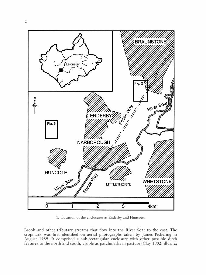
Enclosure II is located 1.5km northeast of Enderby, 100m to the north of LeicesterLane and 300m to the west of the A46 (SP 550 999). The site lies on a slight east-facing slope, on a boulder clay ridge overlooking the confluences of Lubbesthorpe
1234567891012345678910123456789101234567891012345678911
Trans. Leicestershire Archaeol. and Hist. Soc., 78 (2004)
2
Brook and other tributary streams that flow into the River Soar to the east. Thecropmark was first identified on aerial photographs taken by James Pickering inAugust 1989. It comprised a sub-rectangular enclosure with other possible ditchfeatures to the north and south, visible as parchmarks in pasture (Clay 1992, illus. 2;
1. Location of the enclosures at Enderby and Huncote.

IRON AGE ENCLOSURES AT ENDERBY 3
1234567891012345678910123456789101234567891012345678911
2. Enclosures I and II and associated features at Enderby
4
Sharman and Clay 1991, illus. 4). Excavation of the enclosure was undertaken byULAS in 1996, prior to development of the area. The enclosure is one of two identifiedwithin the area of the Grove Park development. The other was a larger ‘D’-shapedenclosure, identified as a cropmark, which lay some 350m to the north (SK 551 001,illus. 2 Enclosure I). Enclosure I was surveyed by fieldwalking and magnetometerbetween 1981 and 1982 by the Leicestershire Museum’s Archaeology Section (LMAS)and the University of Leicester Department of Archaeology, followed by two seasonsof partial excavation in 1983 and 1984 by Leicestershire Archaeological Unit (LAU),directed by Patrick Clay. The enclosure was discovered to be of late Iron Age date,probably originating in the late 1st century BC containing contemporary and possibly
3. Excavated area of Enclosure II at Enderby.
IRON AGE ENCLOSURES AT ENDERBY 5
earlier circular structures (Clay 1992). A watching brief by University of LeicesterArchaeological Services in 1996 revealed further circular buildings within and to thesouth of the enclosure (illus. 2; Ripper and Beamish 1997).
Proposed development of the Grove Park site at Enderby by Centre 21 Ltd, in whichEnclosure II lies, prompted advice from the Leicestershire Museums Senior PlanningArchaeologist, as advisor to the planning authority, to request archaeologicalevaluation and recording of the cropmark as part of the planning conditions.
The cropmark enclosure at Enderby was first evaluated by trial trenching in thesummer of 1990 by the LAU (Sharman and Clay 1991). The evaluation targeted thearea of the enclosure, the line of the Fosse Way Roman road to the south as well asother fainter cropmark features to the north and south. The trenches located on thecropmark enclosure revealed minimal evidence for the enclosure ditch, due to very dryground conditions, although numerous internal features were revealed suggesting thepresence of at least two round houses. A cremation in a pottery vessel was also locatedduring these works. A second phase of evaluation was undertaken at the site in March1995 by the LAU in the area immediately surrounding the cropmark. A number offeatures were located, including part of the enclosure ditch, post holes, ditches andgullies.
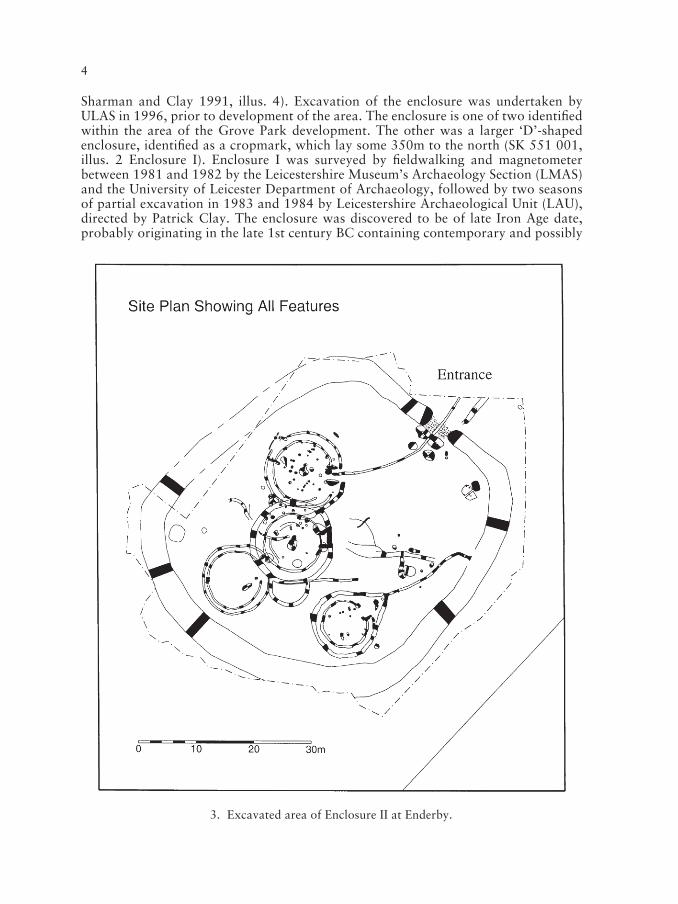
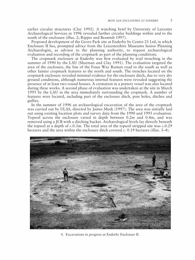
In the summer of 1996 an archaeological excavation of the area of the cropmarkwas carried out by ULAS, directed by James Meek (1997). The area was initially laidout using existing location plots and survey data from the 1990 and 1995 evaluation.Topsoil across the enclosure varied in depth between 0.2m and 0.4m, and wasremoved using a JCB with a ditching bucket. Archaeological levels lay directly beneaththe topsoil at a depth of c.0.3m. The total area of the topsoil stripped site was c.0.29hectares and the area within the enclosure ditch covered c. 0.19 hectares (illus. 3–4).
1234567891012345678910123456789101234567891012345678911
4. Excavations in progress at Enderby Enclosure II.
6
As the site strip progressed the archaeological remains of circular buildings wererevealed and assigned numbers in the order that they were recorded. Roundhouse 1was the most northerly structure, Roundhouse 2 is located in the southeastern part ofthe enclosure, Roundhouse 3 in the southwest and Roundhouse 4 in the centre. Theterm Roundhouse used in this report does not necessarily indicate that they were allused as dwellings (below p.17).
Following the excavation and during construction work at the site a watchingbrief was undertaken by ULAS in the areas around both of the cropmark enclosuresand further archaeological observation was carried out by the Leicestershire CountyCouncil Museums Service across the remainder of the Grove Park developmentarea.
Phasing
The stratigraphical phasing of the Enderby enclosure is somewhat conjectural due tothe lack of many intercutting features. The enclosure ditch itself had episodes ofrecutting evident within the excavated ditch sections, although there were no directrelationships with other features on the site. Roundhouse 4 was stratigraphicallyearlier than Roundhouses 1 and 3. Roundhouse 2 had no stratigraphic relationshipwith other structures on the site, although its archaeological remains were directlycomparable with Roundhouse 4. It also had a drainage gully that ran into theenclosure ditch demonstrating it must have been contemporary with the enclosure.
Archaeological activity can be divided into two broad structural phases,demonstrating occupation of the enclosed area. Both parts are characterised by a pairof roundhouse structures within the enclosure, and associated drainage features.Other archaeological activity was revealed and recorded within the enclosure whichmay suggest some earlier structures on the site, although these were very fragmentary.These included curvilinear gullies, possibly associated with roundhouse structures,and stratigraphically earlier than Roundhouse 4, perhaps indicating pre-enclosureoccupation. Numerous post holes were also recorded across the site that couldpossibly suggest other structures or fence lines, although these cannot be easilyattributed to any specific phase. The location of some of these features within thefootprints of the roundhouse structures would preclude them from being of the samephase (except in the cases where they are likely to form part of the structure).
Discrete features were present on the site, including an oven in the northeastern partof the enclosure and a shallow pit in the southwestern corner. They are presumed to becontemporary with the enclosure, but cannot be confidently attributable to eitherstructural phase.
Structural Phase 1 (illus.5)
This phase of activity includes the construction and occupation of Roundhouses 2 and4 within the area of the enclosure ditch, both with east-facing entrances. The largerstructure, Roundhouse 4, measures c.10.2m in diameter internally, the remains ofwhich were made up of two concentric ring gullies with a large central post hole. Theinternal ring is presumed to be structural, and a number of sections excavated throughit would appear to demonstrate that it would have served as a bedding trench for wallpanels. This internal ring terminated on both sides of the entrance with post holesettings at the entrance to form a doorway. The external ring gully would have been for

IRON AGE ENCLOSURES AT ENDERBY 7
drainage, and completely circuited the building, being present even across the entranceto the building, which would have required some form of bridging to allow access to thestructure. On the southern side of the outer ring gully a semi-circular gully projectedout from the external gully. The gully was very similar in character to that of the mainouter gully and it may have surrounded a semi-circular annex to Roundhouse 4. If thisinterpretation is correct the presence of the ring gully between the main structure andthis possible annex would have required bridging. In the area to the east of the entranceto Roundhouse 4 a shallow gully was excavated, although this had been badly
1234567891012345678910123456789101234567891012345678911
5. Enderby, Enclosure II Phase 1.

8
truncated by later ploughing. If projected this gully would link with the outer gully infront of the entrance to the building, and also project towards the enclosure ditch to theeast. The comparative shallowness of this gully with that externally circuiting thebuilding would mean that if they are indeed contemporary and interconnectingfeatures, this gully would have acted as an overflow for the eaves drip.
The second structure, Roundhouse 2, was slightly smaller, at c.7.7m in diameter.The remains of the structure consisted of two concentric ring gullies, although in this
6. Enderby, Enclosure II Phase 2.

IRON AGE ENCLOSURES AT ENDERBY 9
case no central post hole was present. The internal ring gully also suggested that it wasbuilt as a bedding trench for wall panels, which terminated at either side of theentrance in post holes for the doorway. The external gully of this structure projectedout from the entrance of the building to form a ‘Y’ shape at which point a drainagegully ran out into the enclosure ditch. A radiocarbon date (Wk-8241; see table) wasobtained from charcoal in the fill of this gully. Potentially the shallow gully projectingfrom Roundhouse 4 would have also connected with this drainage gully.
The original evaluation in 1990 revealed a cremation in a pottery vessel in the areabetween the entrance to the structure and the ‘Y’-shape of the outer drainage gully.Although the vessel was initially dated to the Anglo-Saxon period (Elsdon 1991), anIron Age date is now suggested (below p.14).
Structural Phase 2 (illus. 6)
The second main phase of activity within the enclosure is represented by the constructionof Roundhouses 1 and 3, again both with east-facing entrances. Both structures cutRoundhouse 4, although there was no direct relationship with Roundhouse 2.
The remains of Roundhouse 1 were two concentric ring gullies around a largecentral post hole. The internal ring gully was a shallow feature, probably a setting fora ground beam from which the walls of the structure were built, measuring c.10.2m indiameter. The gully is terminated on the northern side of the entrance with post holesettings; on the southern side later truncation from ploughing had removed thecontinuation of the shallow internal ring gully in the area adjacent to the entrance. Thepost hole settings would suggest the presence of a covered porch projecting from theentrance. A later ring of post holes cutting this internal ring gully, probably indicaterepairs. The outer ring is presumed to have been a fairly shallow eaves drip gully,which also terminated on either side of the structure’s entrance, and had been againremoved by later truncation from ploughing in the area adjacent to the south of theentrance. A third concentric arcing gully was also present on the southern side of theentrance to the building, of a more substantial depth. This feature containedconsiderable amounts of pottery and charcoal from which a radiocarbon date (Wk-8243; see table) was obtained.
Projecting from the entrance to the building was a linear gully which curved awayfrom the building and exited through the centre of the enclosure entrance. It ispresumed that this feature is also associated with drainage and its relationship with theexternal eaves drip gully has been lost due to plough truncation. The entire length ofthis feature must logically have been covered to allow it to be safely crossed.
Roundhouse 3 also comprises a pair of shallow concentric ring gullies. These hadbeen considerably truncated by later plough activity, highlighting their insubstantialnature in comparison to the ring gullies of the earlier structural phase. The internalring gully was again presumed to be a structural beam slot or bedding trench fromwhich the walls were built, which measured c. 9.5m in diameter. The terminals of theinner ring gully at the entrance to the structure were badly truncated, and no evidencefor post holes was revealed. The external ring is thought to have been an eaves dripgully, although it seemed very insubstantial. No directly associated drainage featureswere revealed for this structure although a possible linear gully did protrude from thesouthern side of the house entrance, in an area that had been affected by later ploughtruncation, perhaps having removed any relationship. Within the footprint of thebuilding was a large oval pit which contained Iron Age pottery.
1234567891012345678910123456789101234567891012345678911

10
Table of radiocarbon dates calibrated following Stuiver et al (1993).
Lab code Context/Sample material Years BP dC13WK-8241 Charcoal rich fill of butt end of outer gully at the 2150 +/– 60 –26.3
entrance to Roundhouse 2. Context 1670 - very silty clayfill with abundant charcoal
WK-8242 Fill of post pit at the entrance to the enclosure, containing 2100 +/– 60 –25.1a large amount of charcoal. Potentially remnant of the post.Context 1313 – very silty clay fill
WK-8243 Charcoal rich fill from the extra outer gully of 2130 +/– 60 –26.0Roundhouse 1 on the southern side of the entrance.Context 12 – very silty clay fill
Lab code Years BP 1 Sigma 2 SigmaWK-8241 2150 +/– 60 Cal BC 350BC–320BC (9.2%) Cal BC 370–10 AD
Cal BC 230–BC 220 (1.6%)Cal BC 210–BC 50 (57.4%)
WK-8242 2100 +/– 60 Cal BC 200–BC 40 Cal BC 260–BC 280 (9.9%)Cal BC 260–30 AD (85.5%)
WK-8243 2130 +/– 60 Cal BC 360–BC 290 (20.4%) Cal BC 380 – BC 40Cal BC 240–BC 90 (47.8%)
The Enclosure
The enclosure ditch must have been present during both structural phases ofoccupation although there may also have been earlier pre-enclosure occupation (abovep.6). It is evident that in Phase 1 Roundhouse 2 has an indirect relationship with theenclosure ditch, as the drainage gully appears to project from the structure and runsinto the ditch. In Phase 2 the drainage ditch projecting from Roundhouse 1 curves in
7. Post holes of the enclosure entrance at Enderby Enclosure II.

IRON AGE ENCLOSURES AT ENDERBY 11
order to exit through the very centre of the enclosure entrance. At least one phase ofrecutting of the enclosure ditch was evident from the excavated sections through theditch.
The enclosure ditch terminated in butt ends on either side of the northeast facingentrance. Between the two terminals was an area of gravel which had been badlytruncated but presumably represented the remains of a trackway into the enclosure.On the inside of the ditch terminals were two large post pits that presumably formedpart of a gateway into the enclosure (illus. 7). Charcoal from the post pipe of the mostsoutheastern post setting provided a radiocarbon date (Wk-8242; see table).
The size of the ditches and the other features would suggest an imposing entrance.The excavated post pits potentially showed evidence of repairs or rebuilding of theentrance gateway. Although there was no direct relationship between the twostructural phases and the entrance features, it is likely that there would have been asimilar gateway structure for each phase.
The numerous post holes scattered around within the enclosure may represent otherstructures such as fences lines, four post structures and also a possible rectangularstructure. These cannot be confidently attributable to any phase, although theirpreclusion from either phase 1 and 2 can be discerned where post holes/features liewithin the footprints of buildings to which they are unlikely to be associated.
In general the enclosure dates from the later Iron Age, and may have been in use fora period of less than 100 years, being abandoned prior to the Roman conquest withthe settlement possibly moving further to the north on to higher, and presumably drierground. A sequence of occupation can be suggested as follows:
1. Occasional flint finds suggest possible pre-Iron Age activity, although the recoveredmaterial was in insufficient quantity convincingly to suggest settlement. One of themost interesting pre-Iron Age finds from the site was a fragment of the butt end ofa Neolithic battle-axe. A Group I Cornish Epidionite stone axe or chisel had beenfound associated with Enclosure I (Clay 1992, 54, Fig.30.8). Some pre-Iron Ageclearance of woodland in the area is likely.
2. A number of shallow arcing gullies were recorded in the area of Roundhouse 4 thatsuggest earlier structures were present on the site. These features have no directrelationship with the enclosure ditch but may indicate pre-enclosure occupation.
3. The first main phase of activity associated with the enclosure occurs with theconstruction of the two structures within the D-shaped enclosure. The remains ofboth roundhouses (2 and 4) share similar characteristics, by which they have beenassociated. The structures have fairly deep cut internal/structural gullies, and alsodeep cut external drainage gullies. The external gully of Roundhouse 2 leads fromthe entrance of the structure and runs into the enclosure ditch. It is thought likelythat the larger structure Roundhouse 4 was for domestic use while Roundhouse 2may have functioned as a workshop or kitchen. A similar interpretation was putforward for Enderby Enclosure I Phase 2.1 (Clay 1992, 29). However, whilst thisbuilding was associated with concentrations of butchered bone and cereal remainsthere was no clear differentiation in distributions of cereal remains between thebuildings in Enclosure II (illus. 8). A possible four-post structure may also beassociated with this phase, located within the later footprint of Roundhouse 1. Acremation was also recovered on the site in the area in the entrance to Roundhouse2. The vessel within which the cremation had been placed is of unusual form. When
1234567891012345678910123456789101234567891012345678911
12
first analysed it was dated as Anglo-Saxon, due to its form and fabric, althoughfurther analysis and the location of the vessel now suggests it may be of Iron Agedate (see below, p.14).
4. The second main phase of activity is also represented by two structures locatedwithin the enclosure ditch. Roundhouse 1 is the larger, which again is likely to befor occupation, with the smaller Roundhouse 3 perhaps being a kitchen orworkshop. Both structures were stratigraphically later than Roundhouse 4, buthave no direct relationship with Roundhouse 2. Both structures are characterisedby a double ring of gullies, which are all notably shallower than those of the earlierphase, presumably indicating a different construction technique. A possibledrainage gully was recorded at the entrance to Roundhouse 1, which projected in acurve to exit through the enclosure entrance. A second concentric arc was seenaround Roundhouse 1 on the southern side of the entrance.
5. The enclosure ditch which was substantial, demonstrated at least one phase of re-cutting. The northeast facing entrance would appear to have had an elaborateentrance, with two large post pits lying just within the enclosure, the centres spacedsome 2.6m apart (illus. 7). The size of the ditch would suggest that there wouldhave been a sizeable bank created from the excavated material. Such enclosuresoften have an internal bank, although at Enderby this is thrown into some doubt, asboth Roundhouse 2 and the later Roundhouse 3 lie too close to the ditch for a bankto have been present, unless the structures were partially built into the bank toprovide more shelter, possibly because of their function (both structures areinterpreted to be kitchens or workshops). The external gully of Roundhouse 2drains into the ditch, which could again be seen to suggest either no or anintermittent internal bank was present, or that the bank was bridged over the drain.
6. There is no evidence for occupation of the site in the Roman period. A number ofsherds of late Roman pottery were recovered from the upper fills of the enclosureditch, demonstrating that the enclosure ditch had either silted up or been backfilledby this time. Perhaps the abundance of drainage features seen on the site mightsuggest that water was becoming a problem in this location with the settlementbeing eventually abandoned and moved up hill to Enclosure 1 on higher, andpresumably drier, ground.
The Iron Age and Roman Pottery Patrick Marsden, Elaine L. Morris
In terms of fabric there are discernible trends between the first (Roundhouses 2 and 4)and the second (Roundhouses 1 and 3) structural phases of the enclosure. It isapparent that both local mudstone fabrics and local sandy wares are more in evidencein the later phase. The granitic fabrics, possibly from the Charnwood area, show lesssignificant differences between the phases. The evidence suggests that there is asubstantial increase in the use of local pottery in the second structural phase.
Only two large concentrations of pottery were recovered (illus. 8). The first depositwas recovered from the second arcing outer ring gully of Roundhouse 1 that containedthe remains of several different vessels. Similar concentrations have been found at IronAge sites, including locally at Enderby Enclosure I (Elsdon 1992a) and Elms Farm,Humberstone (Marsden 2000). In this case it is thought that the deposit representsdomestic discard relating to the second structural phase, rather than being ‘structured

IRON AGE ENCLOSURES AT ENDERBY 13
deposits’ as has been interpreted for other sites (Hill 1995; Marsden 1998a). Thesecond concentration was recovered from the large pit located in the footprint ofRoundhouse 3, which contained abraded and fragmented pottery, again probablyrepresenting domestic debris. This is also thought to be part of the second structuralphase and potentially associated with the use of the building, although its associationis questionable.
The pottery assemblage recovered from this enclosure is similar to that fromEnderby Enclosure I (Elsdon 1992a). Parallels can also be drawn with otherLeicestershire and East Midlands assemblages, most of the pottery being of a typicalEast Midlands scored ware type assemblage of the middle to late Iron Age,corresponding to Knight’s Group 2 (Knight 1984, 40).
In terms of trading networks the granitic fabrics suggest that pottery was beingbrought in from the Charnwood Forest area to the north. This fabric forms the majorpart of the pottery assemblage (c. 93%) from the first structural phase (1094g), andless than half of that of the second (c. 40% – 2589g). This means the Charnwood areawas part of a trading network in Iron Age, and earlier prehistoric pottery to sites inLeicestershire and the East Midlands region. The majority of pottery from the secondstructural phase is of local mudstone fabrics (c. 54% – 3490g), whereas these formonly a minute part of the first phase (c. 0.02% – 25g). The shell-tempered group mayshow links with social groups in a broadly eastwards direction in southeastLeicestershire, Rutland or Northamptonshire.
Three body sherds of Cheshire briquetage were also identified. Briquetage vesselswere hand made from distinctively gritted, very sandy fabrics, shaped as truncatedcones or vases with open, flared rims and were used to dry and transport salt (Morris1985, fig. 8). The discovery of these sherds at this site and at Enclosure I (Elsdon1992a), is a major expansion of the distribution of Cheshire salt in ceramic drying andtransportation vessels from what was the known distribution in the mid-1980s(Morris 1985, figs. 9–10). It is now quite clear that the salt transported in these specialand visually distinct containers, or salt packs, must have been well-prized to be tradedsuch distances, particularly when salt could have been obtained from the Fenlandregion which is nearer than Cheshire. Briquetage has also been found at Huncote(below p.25), Kirby Muxloe (Cooper 1994) and at Coventry Road, Hinckley(Chapman this volume).
Only a small assemblage of Roman pottery was recovered from the site, all greyware fabrics. These include a necked jar with a ‘double-bead’ rim from the upper mostfill of the enclosure ditch, such forms are paralleled in the East Midlands burnishedware tradition. A 4th century date is probable.
The Cremation
An almost-complete vessel, containing calcined bones, was also found in a fragmentedstate outside the entrance of Roundhouse 2 (illus. 8). The form is globular with aneverted rounded rim, concave neck and rounded base. Elsewhere the vessel has beenpublished as Anglo-Saxon and paralleled at the Pagan Saxon cemetery at Millgate,Newark and conventionally dated from the earlier 5th to the earlier 7th centuries AD(Kinsley 1989; Elsdon 1991, 10–11 and fig.9). However definite dating is problematicas although the base has a rounded form, which is not characteristic of Iron Agepottery, whereas rounded bases are known during the early Anglo-Saxon period (e.gKinsley 1989, fig.75 no.327), when the base is excluded, typologically the vessel’s
1234567891012345678910123456789101234567891012345678911

14
globular form and everted rounded rim does fit in with the tradition of middle to lateIron Age pottery. The fabric of the vessel corresponds to a known Iron Age fabric, butit is not directly comparable to any of the Anglo-Saxon fabrics so far known fromLeicestershire at, for example, Causeway Lane, Leicester, (Blinkhorn 1999) or EyeKettleby, Melton Mowbray (Cooper forthcoming). Furthermore, Anglo-Saxon vesselsfrom the region often display a smoother finish resulting from burnishing on externaland internal surfaces which here is absent. Although urned cremations are rare in theIron Age and more characteristic of the early Anglo-Saxon period they are notcompletely unknown in the county, for example one has been found at MarketHarborough (Liddle 1982, 27). In summary, this is a good example of the difficultieswhich can occur in dating hand-made pottery even when large amounts of the vesselare present. Whether Anglo-Saxon or Iron Age the urn would appear to be atypical ofeither period.
The cremation vessel is located close to the entrance of Roundhouse 2. Burials insimilar locations adjacent to structure entrances have been recorded at other Iron Agesites such as at Whissendine where an inhumation was located, adjacent to theentrance to a structure (J. Browning pers. comm.). On the basis of the fabric of thecremation vessel and the location of its deposition an Iron Age date is suggested.
The cremated remains Simon Chapman
The results obtained from the analysis of this cremated bone has been sufficient tosuggest that the body of at least one human being was cremated and given a secondary‘urned’ burial. The remains of the bones displayed considerable warping whichsuggests that the cremation was that of a body ‘in the flesh’ rather than of excarnateddry bones which rarely become misshapen in this manner (Baby 1954, 5). The bonefragments were heavily calcined and fragmented suggesting that a high temperaturewas maintained during the cremation of the body of the individual, leading to thealmost total combustion of the organic bone constituents. As so few bones survived,and these were in a very fragmentary state, no reliable information pertaining to theage and sex of the cremated individual could be retrieved.
Animal Bone Jennifer Browning
A total of 626 animal bone fragments was recovered from deposits excavated duringevaluation, excavation, and watching brief at the Iron Age site at Enderby. A report onthe bone from the 1990 evaluation has been published (Baxter 1991). Most of thebone was recovered from roundhouse gullies and associated features (totalling 41%),whilst only 8% of the material was recovered from the enclosure ditches;unfortunately, it was generally in a very poor state of preservation. There were nocomplete bones in the assemblage and the majority of fragments were small andabraded. Most of the identified elements were teeth.
The remains of cattle, sheep/goat, pig, and horse were identified in the assemblage.The poor quality of the recovered assemblage precludes a detailed statistical analysis.The nearby site of Grove Farm in contrast produced almost 1000 identified fragments,

IRON AGE ENCLOSURES AT ENDERBY 15
whereas only 157 specimens (25% of total) were identified from the present site.However, as at Grove Farm (Gouldwell 1992), cattle dominate the assemblage andprobably contributed the most to the diet. There were 132 calcined fragments,comprising 21% of the total assemblage. It may be safely assumed that the presence ofcattle, sheep/goat and pig at the site is evidence for the diet of the inhabitants, and thisconclusion is supported by the, albeit scant, butchery evidence. All of the marksobserved were fine knife cuts, these were also noted on pig, cattle and sheep-sizedbones around articulations such as the proximal ulna, mandible and also on ribs. This
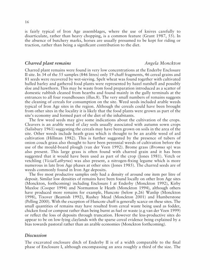
1234567891012345678910123456789101234567891012345678911
8. Distribution of pottery concentrations and cereal evidence.
16
is fairly typical of Iron Age assemblages, where the use of knives carefully todisarticulate, rather than heavy chopping, is a common feature (Grant 1987, 55). Inthe absence of butchery marks, horses are usually presumed to be kept for riding ortraction, rather than being a significant contribution to the diet.
Charred plant remains Angela Monckton
Charred plant remains were found in very low concentrations at the Enderby EnclosureII site. In 34 of the 55 samples (846 litres) only 19 chaff fragments, 46 cereal grains and81 seeds were recovered by wet-sieving. Spelt wheat was found together with cultivatedhulled barley and gathered food plants were represented by hazel nutshell and possiblysloe and hawthorn. This may be waste from food preparation introduced as a scatter ofdomestic rubbish cleaned from hearths and found mainly in the gully terminals at theentrances to all four roundhouses (illus.8). The very small numbers of remains suggeststhe cleaning of cereals for consumption on the site. Weed seeds included arable weedstypical of Iron Age sites in the region. Although the cereals could have been broughtfrom other sites in the locality it is likely that the food plants were grown as part of thesite’s economy and formed part of the diet of the inhabitants.
The few weed seeds may give some indications about the cultivation of the crops.Cleavers is an arable weed of clay soils usually associated with autumn sown crops(Salisbury 1961) suggesting the cereals may have been grown on soils in the area of thesite. Other weeds include heath grass which is thought to be an arable weed of ardcultivation (Hillman 1982). This is further suggested by the presence of tubers ofonion couch grass also thought to have been perennial weeds of cultivation before theuse of the mould-board plough (van der Veen 1992). Brome grass (Bromus sp) wasalso present. This large grass is often found with charred grain and it has beensuggested that it would have been used as part of the crop (Jones 1981). Vetch orvetchling (Vicia/Lathyrus) was also present, a nitrogen-fixing legume which is morenumerous in late Iron Age phases at other sites (Jones 1985). The charred seeds are ofweeds commonly found in Iron Age deposits.
The five most productive samples only had a density of around one item per litre ofdeposit. Similar low densities of remains have been found locally on other Iron Age sites(Monckton, forthcoming) including Enclosure I at Enderby (Monckton 1992), KirbyMuxloe (Cooper 1994) and Normanton le Heath (Monckton 1994), although othershave produced more remains for example, Huncote (below p.26) Wanlip (Monckton1998), Tixover (Beamish 1992), Rushey Mead (Monckton 2001) and Humberstone(Pelling 2000). With the exception of Huncote chaff is generally scarce on these sites. Thesmall quantities of remains may have resulted from cereal waste being used as fodder,chicken food or compost rather than being burnt as fuel or waste (e.g van der Veen 1999)or reflect the loss of deposits through truncation. However the less-productive sites doappear to be on low-lying claylands with the sparse cereal evidence being explained by abias towards pastoral rather than an arable economies (Monckton forthcoming).
Discussion
The excavated enclosure ditch of Enderby II is of a width comparable to the finalphase of Enclosure I, although encompassing an area roughly a third of the size. The

IRON AGE ENCLOSURES AT ENDERBY 17
ditch is substantial, being twice as wide as that excavated at Huncote (below p.20),measuring c.3.5m in width and c.1.45m in depth. As is detailed above, there is no clearevidence for a bank to have been present at Enclosure II making it unlikely that anyinternal bank would have been a continuous earthwork. An elaborate entrance to theenclosure on the northeastern side is suggested, marked by two large butt ends of theditch with an area of deposited gravels between and large post pits adjacent to theseinternally, indicating the presence of a gateway. For any gateway to be functional atthis point, there must have been some boundary between the ditch and the posts,perhaps a partial internal bank just at the entrance. There was no surviving evidence tosuggest the presence of fence lines here.
The size of the enclosure ditch and the elaborate entrance is similar to the ‘WootonHill’ type Iron Age enclosures which have been identified in Northamptonshire(Jackson 1989; Dix and Jackson 1989; e.g. at Wooton Hill, Draughton, Doddington),which are now dated to the 2nd and 1st centuries BC (J. Taylor pers. comm.). Thewidth of the ditches is similar, although many of the Northamptonshire examples aredeeper. This style of enclosure also has similar arrangements of features with roughlysymmetrical post pit arrangements on the inside of the entrances, such as atAldwinkle, Wakerley, Weekley and Wooton Hill in Northamptonshire (Jackson 1989,19; Dix and Jackson 1989), ‘Wooton’ style enclosures are thought to demonstrate theneed for defended settlements at this time; there is however no clear evidence fromEnclosure II that the ditch and entrance were anything more than a visual statement,an indication perhaps of the perception of the inhabitants of their own status. Therange of radiocarbon dates obtained from Enclosure II does not discount thisenclosure being contemporary with the Northamptonshire examples.
The circular structures within the enclosure not only appear to represent twodistinct structural phases, but also two structural techniques. The first phase ischaracterised by deep concentric ring gullies, with the internal ring of Roundhouse 4being a steep-sided trench probably created to take pre-constructed wall panels ornumerous vertical wooden posts. A steep sided trench along the internal ring was notas evident in Roundhouse 2. The later structural phase was characterised by farshallower concentric ring gullies, perhaps used as a setting for a ground beam as a basefor the walls. The two larger houses of each structural phase had central post holes,perhaps indicating that the larger size of these structures required an additionalsupport. The larger structures are also both likely to have been domestic structures foreither a single or extended family. The smaller structures are thought to be more likelyto be for ancillary purposes, such as workshops or kitchens, although there is noconclusive evidence to clarify this.
The evidence from Enderby Enclosure II suggests that there were two main structuralphases associated with the enclosure. If it is presumed that the maximum life-span for atimber roundhouse may be about 50 years, assuming some element of repair andrebuild, then it is possible that Enclosure II was only in use for domestic purposes for c.100 years, perhaps serving as home to successive generations of a single family, perhapsof some elevated status. In view of its low-lying position the abandonment of theenclosure for domestic purposes may eventually have occurred due to continualproblems with water-logging, as suggested by the drainage gully elements. Enclosure Iat Enderby is a larger enclosure, seemingly of later date than Enclosure II, the phasingof which included smaller elements, that was then enlarged to enclose an area almostthree times the size of Enclosure II (Clay 1992, 24). It is possible that Enclosure I,located to the north on higher ground presumably with fewer problems of drainage,
1234567891012345678910123456789101234567891012345678911
18
replaced Enclosure II. A number of other circular structures were recorded during thewatching brief in the areas around Enclosure I during groundworks for the Grove Parkdevelopment that may represent the enlargement of the Iron Age settlement (illus. 2).However the nature of this watching brief work was such that no stratigraphical ordating evidence was recovered to confirm this.
A distinctive characteristic of the structures within the Enderby II enclosure is therequirement for drainage gullies leading off from the main external eaves drip. This isvery clear in Roundhouse 2 of the earlier phase and Roundhouse 1 of the later, but isless definite in Roundhouse 4 and 3 (earlier and later phases respectively). Theimplication would be that water accumulation was a problem, perhaps due to the low-lying nature of the site and the poor drainage capabilities of the clay subsoil. Thepositioning of the gully leading from Roundhouse 1 through the centre of theentranceway of the enclosure is curious. There appears to have been a deliberateattempt to avoid linking this gully with the enclosure ditch, and for it to project out ofthe entrance. It could be seen to suggest that whatever went into the gully was notwanted either around the house or in the surrounding enclosure ditch, which could beas simple as removing rain water/waste products from the site or for a moresymbolic/spiritual purpose. A similar arrangement of a gully exiting through the centreof an enclosure entrance has been recorded at Draughton in Northamptonshire(Knight 1984, fig. 30).
Iron Age rectilinear buildings are known from Leicestershire at Normanton le Heath(Thorpe et al, 1994), Rearsby (M. Beamish pers.comm.) and Wanlip (Beamish 1994).A common feature of Iron Age settlements are four-post structures, often interpretedas granaries, examples of which have been recorded at, for example, Enderby,Enclosure I (Clay 1992), Kirby Muxloe (Cooper 1994) and Wanlip (Beamish 1998a).Two and three post structures have also been recorded on Iron Age sites, such as theentrance features within Enclosure II. Many other post holes were recorded withinEnclosure II and although some of these may represent structural elements to theroundhouses, it is likely that others formed structures in their own right. Just to thesouth of centre of Roundhouse 1 is a group of post holes that form a square, whichmay be part of a rectangular structure pre-dating the circular building (illus. 3). Otherrectilinear gullies to the west of this roundhouse may also represent the remains ofanother structure (illus. 3).
Both animal bone and environmental evidence were not recovered in any greatquantities from the Enderby Enclosure II site, which will be partly due to the nature ofthe clay soils not being conducive to the survival of such remains and thecomparatively small area examined. However a mixed economy perhaps with anemphasis on pasture land can be postulated similar to that found at other Iron Agesites in Leicestershire, including Enderby, Enclosure I, Wanlip, Kirby Muxloe, andNormanton le Heath (Monkton 1995 and forthcoming).
To the north of Enclosure II a series of cropmarks were noted on the aerialphotographs from 1989 that suggest the presence of larger, but far less substantiallyditched enclosures connected to the main excavated area (illus. 2). An attempt wasmade to record these features during the 1990 evaluation, but very little evidence wasfound, although this may have been due to the very dry weather conditions before andduring the evaluation masking the features or their patterning only surviving in thetopsoil. It is possible that these features were small ditched boundaries possiblymarking out field enclosures for livestock. If correct this may again suggest that therewas a bias towards pastoral agriculture at the site.

IRON AGE ENCLOSURES AT ENDERBY 19
Huncote Patrick Clay, Martin Shore
The site at Huncote lies 1 km north of the village on Forest Road (illus.1). Anapplication for an extension to Huncote Quarry covering a c.7.5ha area southeast ofthe original quarry was submitted by Acresford Sand and Gravel Co. It was within anarea of archaeological potential as it lies close to locations of prehistoric, Roman,Anglo-Saxon and medieval remains. Of particular note was the discovery of the upperpart of a late Iron Age decorated linch pin within the application area by MichaelMorris, a local metal detector user (illus. 9). A phased series of archaeological workwas undertaken to assess the area including a desk based assessment (Sturgess 1997),geophysical survey (GSB 1997), fieldwalking and metal detecting surveys, (Browning1997) and an open area archaeological evaluation (Beamish 1998b). Noarchaeological remains were located other than a small fragment of copper alloy, witha Celtic style of decoration, found in disturbed soils, with a metal detector and a fewfaint geophysical anomalies which may have archaeological origins.
However during a subsequent watching brief part of an enclosure ditch associatedwith Iron Age pottery was located. Following metal detector survey the remainingdisturbed subsoils were removed using a JCB 3C with a toothless ditching bucket andunder constant archaeological supervision to establish the extent of the archaeologicaldeposits. An excavation was then undertaken by ULAS, directed by Martin Shore(2001). The archaeological deposits located were hand cleaned and planned followingwhich sample sections were hand excavated and recorded.
Following the completion of the work by ULAS, the local amateur archaeological
1234567891012345678910123456789101234567891012345678911
9. Late Iron Age linch pin from Huncote (drawn by R. Knox). Scale 2/3.
20
group, Huncote Heritage, excavated more of the southern area of the enclosure ditchwith the permission of Acresford Sand and Gravel Co., the results of which areincluded in the report.
Results
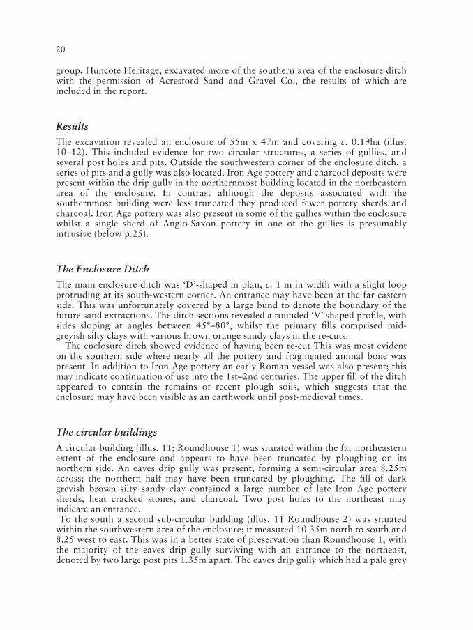
The excavation revealed an enclosure of 55m x 47m and covering c. 0.19ha (illus.10–12). This included evidence for two circular structures, a series of gullies, andseveral post holes and pits. Outside the southwestern corner of the enclosure ditch, aseries of pits and a gully was also located. Iron Age pottery and charcoal deposits werepresent within the drip gully in the northernmost building located in the northeasternarea of the enclosure. In contrast although the deposits associated with thesouthernmost building were less truncated they produced fewer pottery sherds andcharcoal. Iron Age pottery was also present in some of the gullies within the enclosurewhilst a single sherd of Anglo-Saxon pottery in one of the gullies is presumablyintrusive (below p.25).
The Enclosure Ditch
The main enclosure ditch was ‘D’-shaped in plan, c. 1 m in width with a slight loopprotruding at its south-western corner. An entrance may have been at the far easternside. This was unfortunately covered by a large bund to denote the boundary of thefuture sand extractions. The ditch sections revealed a rounded ‘V’ shaped profile, withsides sloping at angles between 45°–80°, whilst the primary fills comprised mid-greyish silty clays with various brown orange sandy clays in the re-cuts.
The enclosure ditch showed evidence of having been re-cut This was most evidenton the southern side where nearly all the pottery and fragmented animal bone waspresent. In addition to Iron Age pottery an early Roman vessel was also present; thismay indicate continuation of use into the 1st–2nd centuries. The upper fill of the ditchappeared to contain the remains of recent plough soils, which suggests that theenclosure may have been visible as an earthwork until post-medieval times.
The circular buildings
A circular building (illus. 11; Roundhouse 1) was situated within the far northeasternextent of the enclosure and appears to have been truncated by ploughing on itsnorthern side. An eaves drip gully was present, forming a semi-circular area 8.25macross; the northern half may have been truncated by ploughing. The fill of darkgreyish brown silty sandy clay contained a large number of late Iron Age potterysherds, heat cracked stones, and charcoal. Two post holes to the northeast mayindicate an entrance. To the south a second sub-circular building (illus. 11 Roundhouse 2) was situated
within the southwestern area of the enclosure; it measured 10.35m north to south and8.25 west to east. This was in a better state of preservation than Roundhouse 1, withthe majority of the eaves drip gully surviving with an entrance to the northeast,denoted by two large post pits 1.35m apart. The eaves drip gully which had a pale grey

IRON AGE ENCLOSURES AT ENDERBY 21
1234567891012345678910123456789101234567891012345678911
10. The location of the linch pin, evaluation and excavated enclosure at Huncote.

22
brown silty clay fill contained fewer finds than Roundhouse 1. The internal featuresincluded several post holes and pits, some of which may not have related to thestructure, the only post configuration conforming to any structural layout, being threeof the post holes which formed a triangle at the centre of the roundhouse. Thesouthern area within the structure appeared to have no features. Here the natural
11. Enclosure at Huncote showing internal features and roundhouse areas.

IRON AGE ENCLOSURES AT ENDERBY 23
ground was a red sandy clay which had seen some plough and land drain truncation,but the drip gully survival was better than that on the northern side of the structure.Along the northwestern side of the interior were two groups of stake holes (twogroups of four holes and two groups of two holes) which may relate to internalstructures. A post pit, post hole and two pits with stake holes in their bases werelocated within the southwestern quarter of Roundhouse 2.
Other features (illus. 11)
There were two main linear gullies within the enclosure on east–west alignmentsjoining the enclosure ditch to the east. They had fills of dark grey-brown silty sandyclays and contained frequent Iron Age pottery sherds, heat cracked stones, andcharcoal deposits. (An Anglo-Saxon sherd in the northernmost gully is likely to beintrusive). The northernmost gully cut the location of Roundhouse 1. In the westernarea of the enclosure, were two parallel north–south aligned gullies the easternmost ofwhich cut the eaves drip gully surrounding Roundhouse 2.
Outside the enclosure to the south-west was an area containing five large pits, agully which cut two of the pits, and six post holes, two of which cut the fills of thegully. No finds were associated with these features. Tree-throw pits were identifiedinside and outside the enclosure some of which were cut by the Iron Age features.
Phasing
An absence of lithics was noted during the evaluation and excavation suggesting thatlittle activity preceded the Iron Age occupation. The only earlier objects found were afragment of a Bronze Age rapier, located from the metal detector survey (below p.25),and two flint flakes from the excavation.
In view of the lack of stratigraphic relationships, along with the difficulty of closelydating undiagnostic Late Iron Age pottery, it is difficult to provide a clear sequence ofactivity associated with the enclosure. However a possible sequence can be suggestedas follows:
1. Some activity during the Later Bronze Age is suggested from the presence of therapier fragment. It is possible that woodland clearance denoted by the presence ofpossible treethrow pits also took place during this period.
2. Two circular structures were constructed. It is unclear whether these werecontemporary. If they were it is possible that one of the buildings was for a dwellingand the other served as a workshop or kitchen building. A similar situation hasbeen interpreted for two nearby settlements at Enderby (above p.17; Clay 1992).
3. The enclosure ditch appears to have post-dated Roundhouse 1 and possibly bothcircular buildings. Drainage gullies and fence lines were constructed within theenclosure. The enclosure ditch was re-cut at least once and may have continued tobe used as a stock enclosure into the early Roman period subsequent to theabandonment of the farmstead as a settlement.
4. A single sherd of Anglo-Saxon pottery would seem to indicate activity on the site
1234567891012345678910123456789101234567891012345678911

24
from that period, (perhaps the excavation of some gullies). A more likelyexplanation is that the sherd was introduced through manuring. From the presenceof plough soils in the upper fills of the enclosure ditch it is possible that theenclosure survived as a visible earthwork into the post-medieval period.
The Iron Age and Roman pottery Patrick Marsden
The pottery from the site consists of fabrics, forms, and decoration typical of scoredwares found elsewhere in the Soar Valley. They include fabrics with inclusions ofigneous rock which may have come from outcrops of syenite situated locally includingone only c.1.5 km to the south at Croft Hill. Similar pottery fabrics have been foundfrom the two Enderby enclosures (Elsdon 1992a; Meek 1997; above p.12) c. 4km tothe north-east. The pottery, including the remaining fabric groups, is likely to be oflocal origin. Although scored wares have a broad date range, from the 4th or 5thcentury BC to the 1st century AD, a vessel recovered from the fill of the enclosure ditchis a necked bowl of late 1st century BC to mid 1st century AD (Thompson 1982). Thisis a Belgic form which is rare on rural sites in Leicestershire, although examples areknown from Leicester (Pollard 1994, fig.54 no.42) and Elms Farm, Humberstone(Marsden 2000, fig.51 no.32). The remainder of the pottery from Huncote, consistsmainly of scored wares, although part of a single grey ware vessel was found by theHuncote Heritage Group in the enclosure ditch, dating to the 1st or early 2nd centuryAD, suggesting activity continuing into, the early Roman period. However, as scored
12. Excavations in progress at Huncote.

IRON AGE ENCLOSURES AT ENDERBY 25
wares may have continued to be produced into the 1st century AD (Elsdon 1992b), itis possible the whole site was occupied during the 1st century AD; this may explain thepresence of native scored wares alongside Belgic style and Roman grey ware vessels. Incontrast to other Iron Age sites, for example Wanlip and Humberstone (Beamish1998a; Charles et al 2000), no deliberate deposition of finds was identified from thesite.
Three sherds of briquetage from the Nantwich area of Cheshire were located.Briquetage which was used to dry and transport salt, provides evidence of long-distance trade during the Iron Age. Huncote is situated within the southerndistribution of Cheshire briquetage although it has now been found at Crick,Northamptonshire (BUFAU 1998).
Early Anglo-Saxon pottery Nicholas J.Cooper
A single sherd of Early Anglo-Saxon pottery weighing 40g was present in thenorthernmost drainage gully. The sherd is from the upper profile of a globular vesselwith an upright rim. The vessel is handmade and the form, the smoothed externalfinish, and the fabric, support an Early Anglo-Saxon attribution.
The fabric contains fragments of crushed granite (granodiorite) from the igneousoutcrops of the Charnwood district and is paralleled by material both from Leicester(Blinkhorn 1999, 165 fabric 4 of coarse granite) and elsewhere in the County such asEye Kettleby, Melton (Cooper forthcoming). In all cases the fabric is the most commonwithin the assemblage and would appear to belong to a broad fabric group known asCharnwood ware, recognised throughout the East Midlands (Williams and Vince1997).
The metalwork Patrick Clay and Martin Shore
A metal detector survey located a damaged silver Iron Age Corieltauvian quarter staterof early 1st century AD date (illus. 10 SF1; Seaby 1984, 4.30). This was from topsoilwithin the eastern half of the enclosure south of Roundhouse 1 (illus. 10. SF 1). ABronze Age copper alloy Rapier blade tip of the Taunton Phase, c.1300 BC waslocated in topsoil to the south of the excavated area (illus. 10. SF2).
The fragment of linch pin (illus. 9), first discovered by metal detecting by MickMorris, to the north of the enclosure (illus. 10), is a crescentic headed type, havingsurviving red and orange enamel with unique distinctive ‘demon’ eyes formed by acentral dividing bar. A similar pin but without the central bar is known from theMiddleton/Enthorpe area of east Yorkshire (MacGregor 1976, 135). Circa 60 IronAge linch pins have been found in Britain usually as part of the surviving remains ofchariot or cart burials notably from East Yorkshire and date from c. 100BC–AD50.The relationship between the linch pin and the settlement is still uncertain although itsproximity suggests that the object may have come from a cart or chariot associatedwith the settlement. Although these objects are often found with cart/chariot burialsthis example may have come from a working vehicle. Whatever its origin the objectprovides a rare insight of the skill and artistic creativity of the Late Iron Age peopleliving in the years just before the Roman conquest.
1234567891012345678910123456789101234567891012345678911
26
The animal bone Jennifer Browning
A total of 126 bone fragments was recovered from the fill of the enclosure ditch. Theyare generally in a poor condition, brittle and highly fragmented and as a consequence,very little of the bone was identifiable. However, it was possible to identify theremains of cattle, horse and sheep/goat in the assemblage. Cattle bones were by far themost frequently represented. The presence of some burnt bone was noted, althoughthe fragments were too small and not diagnostic enough to identify. Teeth are the mostcommon skeletal element recovered. The condition of the rest of the bone suggests thatthis might be due to the soil conditions. Teeth have a denser structure than other typesof bone, increasing their chances of survival.
Charred plant remains Wayne Jarvis
The charred plant remains provide evidence for cereals in the form of spelt wheat,and a little emmer, the latter perhaps being an accidental part of the crop. Spelttypically predominates on sites of this period, although barley is also frequentlypresent (Greig 1991). Eight of the 16 samples (110 Litres) produced a total of 242chaff fragments, 23 cereal grins and 118 seeds. Most of the samples represent a thinscatter (<1.6 items per litre of deposit) of re-deposited material from crop cleaningprocesses carried out nearby. Three samples, however, two from the eaves drip gulleyaround Roundhouse 1, and one from the enclosure ditch, have much higher densitiesof material (14.3 to 19 items per litre of deposit), and are also dominated by cropprocessing waste by-products (cereal chaff and weed seeds). These densities areconsiderably higher than other Iron Age sites in the county, for example the twoenclosures at Enderby and Kirby Muxloe (Monckton 1995). This might suggest agreater emphasis on cereals in the site economy, but it may be that the waste by-product was used for other purposes (e.g. fodder) and is therefore less likely to havesurvived (above p.16).
In productive samples, it is possible to compare the relative proportions ofcarbonised plant material to infer agricultural practices. This is because croppreparation leaves behind differing residues dependant on the crop processing stageinvolved (Hillman 1981, 1984; Jones 1985). With the glume wheats (i.e. emmer andspelt), threshing leaves the grain still held firmly within the chaff (glumes), at whichstage the cereal can be traded and/or stored as spikelets. Storage as spikelets may havetaken place as the chaff protects the grain from damp and pests. To use the grain forfood requires a further stage of parching and pounding to free off these glumes,followed by fine sieving to separate the chaff and weed seeds from the grain. The richsamples from Huncote represent this fine sieving by-product, indicating that cropprocessing, and by inference consumption, occurred on site. However, the grain mayhave been brought onto site as spikelets (and perhaps produced elsewhere).Unfortunately it is difficult to prove a site was involved in crop production as theevidence for the early crop processing stages (light chaff, straw) is rarely preserved,with straw being a valuable product in its own right. Large grain rich deposits asfound on sites in the south might suggest a ‘producer’ site (Jones 1985), but these arerare in the region for this period, even though cereal evidence is usually present(Moffett 1991, Monckton 1992a, 1995). Population differences may in part explainthis contrast. At Humberstone, one of the few sites in Leicestershire to have produced

IRON AGE ENCLOSURES AT ENDERBY 27
grain rich samples, the evidence was associated with a four-post structure which wasinterpreted as a grain store, with the crop being processed nearby and as needed(Pelling 2000). It is likely that assemblages with a thin spread of waste material reflectsmall-scale ‘domestic’ production and consumption, with stored grain being processedas required, rather than in bulk. The Huncote samples probably reflect the waste fromthis sort of processing, with a concentration in the vicinity of roundhouse 1.
The weed seeds are predominantly those of the flora of disturbed ground, andcommonly occur as weeds in ancient and recent arable assemblages (Jones 1988). Theoccurrence of grass seeds is common in archaeobotanical assemblages and reflects themore diverse ecology of ancient arable fields. Additionally, the relatively large seeds ofbrome grass and fat hen are often found with cereal grain, and may have thereforebeen tiresome to pick out (Jones 1981). The presence of hazel nutshell, sloe, and wildcherry/plum fruit stones in the sample from Roundhouse 1 suggests the exploitation of‘wild’ food resources from scrub/woodland margin, or possibly hedgerow. Thisevidence suggests wild plant resources supplemented the cereal diet.
Discussion
The Iron Age site at Huncote includes two small sub-circular buildings. On the basis ofthe eaves drip diameters, the Roundhouse 1 may have been slightly smaller than itssouthern counterpart, Roundhouse 2. Pottery and charred plant remains were moreabundant from the eaves drip gullies surrounding Roundhouse 1 and this may suggestthat this was used as a kitchen or workshop with Roundhouse 2 serving as livingquarters, a situation perhaps paralleled at the two Enderby enclosure (above p.17).
The settlement appears to have been originally unenclosed with an enclosure ditchadded later. A similar sequence has been interpreted for Enderby Enclosure I andpossibly Enclosure II (above p.17). Even allowing for plough erosion the enclosureditch is far less substantial than that at Enderby Enclosure II (below p.28).
The excavation at Huncote, therefore, has revealed evidence of a settlement datingfrom the late Iron Age. The presence of the Belgic style pottery and the Corieltauviancoin may indicate a later date than that at Enderby Enclosure II with occupationcontinuing into the 1st century AD – a similar date range suggested for EnderbyEnclosure I (Clay 1992). Charred cereal remains including spelt and emmer wheat andanimal bone including cattle and sheep/goat were recovered suggesting a small-scalemixed economy, possibly for an extended family group. Although the settlementappears to have gone out of use during the late Iron Age the presence of early Romanpottery in the enclosure ditch suggests that the enclosure was still used into the Romanperiod, perhaps for stock control. Re-use of the enclosure may also have also occurredduring the Anglo-Saxon period. Medieval strip field systems as part of Huncote’s openfields were evident although traces of the earthwork may have survived until the post-medieval period and only been finally eroded during ploughing since the fields wereenclosed.
Discussion
Small settlements such as those examined at Enderby and Huncote are relativelycommon in the Late Iron Age of the East Midlands. Similar sites can be interpretedfrom cropmarks (Pickering and Hartley 1985; Hartley 1989) together with earthwork,
1234567891012345678910123456789101234567891012345678911

28
artefact scatter (querns and pottery) and excavated data. Over 220 locations of LateIron Age occupation are included in the Leicestershire and Rutland Sites andMonuments Record. From analysis of well-surveyed areas including Medbourne,Oakham and Misterton a density of one Late Iron Age site per 1.8–2 sq km can beextrapolated (Clay 2002, 81).
Whilst the majority of Late Iron Age settlements are farmsteads similar to those atEnderby and Huncote consisting of family or extended family groups at the same timelarger settlements are now known to have been developing in the area, at for exampleLeicester and Humberstone (Clay 1985; 2001; Charles et al 2000; Thomas 2003).These are likely to have served as centres of trade for the smaller farmsteads such asEnderby and Huncote which would still have continued to practice an essentially selfsufficient subsistence economy based around family units.
The enclosures at Enderby and Huncote are of very similar size, covering c. 0.19ha.Both enclosures appear to contain a pair of roundhouses at any one time. Huncote hadcertainly suffered more damage from plough erosion than Enderby and this may be thereason why the remains of the structures at Huncote are comparatively slight. AtEnderby differences in truncation from ploughing were evident with the remains ofRoundhouse 3 being very slight and some areas of both Roundhouse 3 andRoundhouse 1 having been totally removed.
The width of the enclosure ditch at Enderby was almost twice that at Huncote andmuch deeper. Even taking into account the increased plough erosion across theHuncote site the Enderby enclosure would still have been far more substantial. Thismay in part be because Enderby Enclosure II was lower lying and likely to be moreprone to waterlogging. The enclosure at Enderby also had a very distinct entrance waywhereas none was located at Huncote although it could have been outside theexcavated area to the east. The entrance to the Enderby enclosure would appear tohave been made to be seen.
Circular buildings similar to those at Enderby and Huncote are amongst the mostcommon structures on Late Iron Age sites and examples have been located on varioussites in Leicestershire and Rutland including, Breedon on the Hill (Wacher 1977),Castle Donington (Coward and Ripper 1998), Enderby (above p.18; Clay 1992),Humberstone (Charles et al 2000; Thomas 2002), Normanton le Heath (Thorpe et al1994), Tixover (Beamish 1992) and Leicester (Clay and Pollard 1994). Two of thebuildings at Enderby Enclosure II are different from many others in the region inhaving central posts. The Phase 2.2 building at Enderby Enclosure I at c. 13.5mdiameter and Enclosure II Roundhouses 1 and 4 at c. 10.2m diameter are amongst thelargest circular buildings known from the East Midlands.
Both farmsteads show evidence of paired buildings, perhaps separating differentfunctions, which was also evident at Enderby Enclosure I (Clay 1992). This occurrenceof paired buildings has also been noted at Aylesby, South Humberside (Steedman andForeman 1995) and Bancroft, Buckinghamshire, although the latter is believed to be ofearlier, broadly ‘Middle Iron Age’, date (Williams and Zeepvat 1994). However theinternal layout of the two enclosures is different. The eaves drip gullies surroundingthe roundhouses at Huncote suggests structures of between 7–9m in diameter. Thetwo larger roundhouses of each structural phase at Enderby are more substantialbuildings the internal diameters of each measuring c.10.2m. In each phase the pairs ofhouses are in positions where they would have dominated the interior of the enclosure.Although some animals may have been housed within the enclosure, the presence ofthe drainage gullies and other features such as the oven in the northeastern corner
IRON AGE ENCLOSURES AT ENDERBY 29
would not have been practical if numerous animals were kept within the enclosure. Itis likely that Enclosure II was constructed as an enclosed settlement for a family group,and possibly one of some status. The entrance way, size of the ditches and also themain structures within would suggest that visual impact was important to theinhabitants.
The evidence from the charred plant remains also shows a difference between thetwo Enderby enclosures and Huncote. At Enderby there is a low frequency of cerealstypical of many other similar Iron Age sites in the region (Monckton 1995, 35 andforthcoming). Whilst mixed agricultural economies can be interpreted for Enderbythere may have been a greater emphasis on a pastoral base, with cattle predominant.In contrast the evidence from Huncote, where there is a higher concentration of cerealremains and chaff survival, suggests perhaps a greater emphasis on arable farming.
From the pottery at Enderby Enclosure I and Huncote it appears that Enclosure I islater than and may have replaced Enclosure II (above p.17), and it is also possible thatit and Huncote were contemporary. Situated only 4km apart they are likely to havebeen in contact with each other and may have shared outfield pasturing areas. Theiruse as settlements appears to have ceased at around the time of the Roman conquestalthough the presence of Roman pottery may indicate that the areas remained inagricultural use.
Conclusion
The two excavations have highlighted both the potential and problems in Iron Agestudies in the East Midlands. Chronology has been identified as a difficulty within theIron Age due to several factors, including the conservatism of regional potterytraditions, the rarity of datable metalwork finds, and the variations withinradiocarbon calibration curve (Haselgrove et al 2001; Willis 2001). At EnderbyEnclosure II in particular diagnostic pottery and metalwork is absent and whencalibrated the radiocarbon dates provide a wide date range. However it does appear tobe earlier than either Enderby Enclosure I or Huncote. Although having no suitablematerial for radiocarbon dating, diagnostic pottery, which could be dated to the early1st century AD was present at Huncote. Whilst datable metalwork is present this wasnot in stratified contexts. However it is highly probable that Huncote and EnderbyEnclosure I were occupied at the same time.
Special deposition of artefacts has been identified on several Iron Age sites (Hill1995) although interpretation of these should be treated with caution. While acombination of different artefacts showing evidence of having been deliberately placedhas been noted at various sites (e.g locally at Wanlip; Beamish 1998a) theinterpretation of concentrations of pottery around entrances as deliberate andstructured might occasionally be open to question as these areas can equally beinterpreted as favoured locations for rubbish disposal (cf. Gwilt 1997; Charles et al.2000, Illus. 42). There is also evidence that enclosure ditches were also a focus forvotive and structured deposits during the Iron Age (cf. Hingley 1990). At Enderby andHuncote there is no clear evidence of structured deposition although the twoconcentrations of pottery at Enderby Enclosure II may reflect this phenomenon, and, ifthe cremation (above p. 13) is of Iron Age date this would appear to have beendeliberately placed immediately to the left of the entrance to roundhouse 2 (illus. 8).
The two projects also highlight the problems of visibility for clayland Iron Agesettlements (Clay 2002, 9). Whilst the enclosures at Enderby were identified by aerial
1234567891012345678910123456789101234567891012345678911

30
photography and recording was concentrated in these areas, occupation southeast ofEnclosure I (illus. 2) was only identified during a watching brief with consequentlimited recording opportunities (Ripper and Beamish 1997). At Huncote fieldwalking,geophysical survey and evaluation failed to locate the enclosure which again was onlyrevealed during a watching brief. Despite these problems the excavations haveindicated that superficially similar sites do have their own complexities and variations.Even small farmsteads, typical of this period, can inform about the everyday life andtimes of the Iron Age and have their own particular distinctiveness.
Acknowledgements
ULAS would also like to thank Ben McCathie, Alan Thorpe and Derek Penman ofCentre 21 Ltd (Enderby), Barry Cooke, Roy Longdon and Stephen Parker of AcresfordSand and Gravel Company and Michael Morris with the Huncote Heritage Group(Huncote) for their help and co-operation during these projects.
The excavation at Enderby was directed by James Meek and that at Huncote byMartin Shore, with the assistance of Simon Chapman (surveying and turbocadillustrations). The animal bone was identified by Jennifer Browning, environmentalanalysis was undertaken by Wayne Jarvis (Huncote) and Angela Monckton (Enderby)and the pottery reports by Patrick Marsden, Elaine L. Morris and Nicholas Cooper.The radiocarbon dates were provided by the University of Waikato, Hamilton, NewZealand. The illustrations were prepared by James Meek. Illustration 9 of the linch pinwas drawn by Richard Knox of Leicestershire County Council, Heritage Services. Theproject manager for both projects was Patrick Clay. Anne Graf of LeicestershireMuseums provided support and planning advice for both projects under PPG16. JohnThomas and Lynden Cooper of ULAS and Jeremy Taylor of University of LeicesterDepartment of Archaeology and Ancient History provided helpful comments. The fullreports on both projects can be obtained from ULAS.
BibliographyBaby, R.S., 1954 Hopwell Cremation Practices, Papers in Archaeology No. 1.Baxter, I.L., 1991 ‘Animal bone’, in J. Sharman and P. Clay 1991, p.11. Beamish, M., 1992 ‘Archaeological excavations along the Anglian Water pipeline at
Tixover, Rutland’, Transactions of the Leicestershire Archaeologicaland Historical Society 66,.p. 183.
Beamish,, M., 1998a ‘A Middle Iron Age site at Wanlip, Leicestershire’, Transactions of theLeicestershire Archaeological and Historical Society 72, pp. 1–91.
Beamish, M., 1998b An Archaeological Evaluation of Metal Detector Finds, HuncoteQuarry Extension, Forest Road, Huncote, Leicestershire. (SP 51609850 ) ULAS Report Number 98/34.
Browning, J., 1997 A Fieldwalking and Metal Detecting Survey for the Huncote QuarryExtension, Forest Road, Huncote, Leicestershire (SP 5160 9850 )ULAS Report Number 97/115.
Blinkhorn, P., 1999 ‘The Saxon Pottery’ in A. Connor and R.J. Buckley and Roman andMedieval Occupation in Causeway Lane, Leicester. Leicester:Leicester Archaeology Monograph 5, p.165.

IRON AGE ENCLOSURES AT ENDERBY 31
BUFAU, 1998 The excavation of an Iron Age Age Settlement at Covert Farm (DIRFTEast), Crick, Northamptonshire Unpublished Assessment report.
Charles, B.M., ‘A Bronze Age ditch and Iron Age settlement at Elms Farm, Humber-Parkinson, A., and stone, Leicester’, Transactions of the Leicestershire ArchaeologicalForeman, S., 2000. and Historical Society 74, pp. 113–222.Clay, P., 1985 ‘The Late Iron Age settlement’, in P. Clay and J. E. Mellor, pp. 29–31. Clay, P., 1992 ‘An Iron Age Farmstead at Grove Farm, Enderby, Leicestershire’,
Transactions of the Leicestershire Archaeological and HistoricalSociety 66, pp. 1–82.
Clay, P., 2001 Leicestershire and Rutland in the First Millennium BC. Transactionsof the Leicestershire Archaeological & Historical Society. 75,pp.1–19.
Clay, P., 2002 The Prehistory of the East Midlands Claylands, Leicester: Universityof Leicester. Leicester Archaeology Monograph 9.
Clay, P., and Excavations in Bath Lane, Leicester, Leicester: Leicestershire Museums,Mellor, J.E., 1985 Art Galleries and Records Service Archaeological Report 10, Clay, P., and Iron Age and Roman Occupation in the West Bridge Area, Leicester.Pollard, R., 1994 Excavations. 1962–1971, Leicester: Leicestershire Museums Arts and
Records Service.Cooper, L., 1994 ‘Kirby Muxloe, A46 Leicester Western by-pass (SK 530 050)’,
Transactions of the Leicestershire Archaeological and HistoricalSociety, 68, pp.162–165.
Cooper, N., ‘The Anglo-Saxon pottery’, in N. Finn forthcoming, Excavations atforthcoming Eye Kettleby, Melton Mowbray, Leicestershire.
Coward, J., and ‘Castle Donington. Willow Farm (SK 445 288)’, Transactions of theRipper, S., 1999 Leicestershire Archaeological and Historical Society 72, pp. 162–165.Dix, B., and ‘Some Late Iron Age defended enclosures in Northamptonshire’, inJackson, D., 1989 A. Gibson (ed.), 1989 pp. 158–79.Elsdon, S. M., 1991 ‘The Iron Age and Anglo-Saxon pottery’ in J. Sharman and P. Clay
1991, pp. 38–52.Elsdon, S. M., 1992a ‘The Iron Age pottery’ in P. Clay 1992, pp. 38–52.Elsdon, S.M., 1992b ‘East Midlands Scored Ware’, Transactions of the Leicestershire
Archaeological and Historical Society 66, pp. 83–91.GSB, 1997 Report on Geophysical Survey, Huncote, Leicestershire GSB Survey
No.97/96.Gibson. A., (ed), 1989 Midlands Prehistory, Oxford: British Archaeological Report (British
Series) 204. Gouldwell. A.G., 1992 ‘The Animal Bone’, in P. Clay 1992, pp. 58–69.Grant, A., 1987 ‘Some observations on butchery in England from the Iron Age to the
Medieval period.’ Anthropozoologica. Premier Numero Special.pp.53–58
Greig J., 1991 ‘The British Isles’ in W. van Zeist, K. Wasylikowa and K. Behre (eds.)Progress in Old World Palaeoethnobotany. Rotterdam: Balkema, pp.299–334.
Gwilt, A., 1997. ‘Popular practices from material culture: a case study of the Iron Agesettlement at Wakerley, Northamptonshire’, in A. Gwilt & C.C.Haselgrove (eds) Reconstructing Iron Age Societies, OxbowMonograph 71, Oxford, 153–166.
1234567891012345678910123456789101234567891012345678911
32
Hartley, R.F., 1989 ‘Aerial archaeology in Leicestershire’, in A. Gibson (ed) 1989 pp.95–105.
Haselgrove,C.C., Understanding the British Iron Age: An Agenda for Action. A report Armit, I., Champion, T., for the Iron Age Research Seminar and the Council of the PrehistoricCreighton, J., Gwilt,, A., Society. Salisbury: Trust for Wessex Archaeology.Hill, J.D., Hunter F. andWoodward, A., 2001Hill, J.D., 1995 Ritual and Rubbish in the Iron Age of Wessex, British Archaeological
Reports (British Series) 242, Oxford.Hillman G., 1981 ‘Reconstruction of crop husbandry practices from charred remains of
crops’ in R. Mercer Farming practices in British prehistory.Edinburgh: Edinburgh University Press, pp. 123–162.
Hillman, G. C., 1982 ‘Crop husbandry at the medieval farmstead, Cefn Graenog’ in R. S.Kelly ‘ The excavation of a medieval farmstead at Cefn Graenog,Clynnog, Gwynedd’. The Bulletin of the Board of Celtic Studies 29.4,pp. 859–908.
Hillman G., 1984 ‘Interpretation of archaeological plant remains: the application ofethnographic models from Turkey.’ in van Zeist W. and Casparie W. A.(eds.) Plants and Ancient Man. Rotterdam: A. A. Balkema, pp. 1–41.
Hingley, R., 1990. ‘Boundaries surrounding Iron Age and Romano-British settlements’,Scottish Archaeological Review, 7, pp. 96–103.
Jackson, D., 1989 ‘Enclosure at Wooton Hill Farm, Northamptonshire’, Northamp-tonshire Archaeology 22 (1988–9), pp. 3–21.
Jones M., 1981 ‘The development of crop husbandry’ in M. Jones. and G. Dimbleby(eds) The environment of man: the Iron Age to the Anglo-Saxonperiod. Oxford: British Archaeological Report (British Series) 87.95–128.
Jones M., 1985 ‘Archaeobotany beyond subsistence reconstruction’ in Barker G.W.and Gamble C. (eds.) Beyond Domestication in Prehistoric Europe.London: Academic Press Inc. (London) Ltd. pp.107–127.
Jones M., 1988 ‘The Phytosociology of early arable weed communities, with specialreference to southern England’ in H. Kuster (ed.) Der PrahistoricheMensch und seine Umwelt. Stuttgart, pp. 43–51.
Kinsley, A.G., 1989 The Anglo-Saxon Cemetery at Millgate, Newark-on-Trent,Nottinghamshire. Nottingham: Nottingham ArchaeologicalMonographs No. 2.
Knight, D., 1984 Late Bronze Age and Iron Age settlement in the Nene and Great OuseBasins. Oxford: Oxford: British Archaeological Report (British Series)130.
Liddle, P., 1982 Leicestershire Archaeology. The present state of knowledge. Part 1 tothe end of the Roman Period, Leicester: Leicestershire Museums ArtGalleries and Records Service Archaeological Report No.4.
MacGregor, M., 1976 Early Celtic Art in North Britain Volume 2. Leicester: LeicesterUniversity Press.
Marsden , P.L., 1998 ‘The Iron Age pottery’ in M. Beamish, 1998a, pp. 44–62.Marsden, P.L., 2000 ‘The prehistoric pottery’ in B.M. Charles et al, 2000 pp. 170–186.Meek, J.E., 1997 ‘Enderby (SP 550 999)’, Transactions of the Leicestershire
Archaeological and Historical Society 70, pp. 88–90.
IRON AGE ENCLOSURES AT ENDERBY 33
Moffett L., 1991 Gamston, plant remains from an Iron Age site in Nottinghamshire.Ancient Monuments Laboratory Report, 110/91. English Heritage,London.
Monckton A., 1992a ‘The Plant Remains’, in P. Clay 1992, pp. 75–77.Monckton A., 1992b ‘The Molluscs’, in P. Clay 1992, pp. 69–74.Monckton A., 1994 ‘The plant remains’, in R. Thorpe, et al 1994, pp. 57–59.Monckton A., 1995 ‘Environmental Archaeology in Leicestershire’, Transactions of the
Leicestershire Archaeological and Historical Society 69, pp.32–41.
Monckton A., 1994 ‘The plant remains’, in M. Beamish, 1998a, pp. 75–82.
Monckton, A., 2001 ‘The charred cereals’, in R. Pollard, ‘An Iron Age inhumation fromRushey Mead, Leicester’, Transactions of the LeicestershireArchaeological and Historical Society, 75, pp. 29–31(20–35).
Monckton A., ‘Investigating past environments, farming and food in Leicester,forthcoming Leicestershire and Rutland: the evidence from plant and animal
remains’, in P. Bowman and P. Liddle Leicestershire LandscapesLeicestershire County Council, Heritage Services.
Morris, E.L., 1985 ‘Prehistoric Salt Distribution: Two Case Studies from WesternBritain’, Bulletin of the Board of Celtic Studies 32, 336–379.
Pelling, R., 2000 ‘The charred and mineralised plant remains’, in B. M. Charles et al2000, pp. 207–213.
Pickering, J., and Past Worlds in a Landscape, Leicester: Leicestershire Museums ArtHartley, R.F., 1985 Galleries and Records Service.Pollard, R., 1994 ‘The Late Iron Age and Roman pottery’, in P. Clay and R. Pollard
1994, pp. 51–114.Ripper, S., and Enderby, Grove Park (SP 550 002), Transactions of the LeicestershireBeamish, M., 1997 Archaeological and Historical Society, 71, pp. 113–14.Salisbury, E., 1961 Weeds and Aliens London: Collins. Seaby B.A., 1984 Seaby’s Standard Catalogue of British Coins. London: B.A. Seaby
Publications Ltd.Sharman J., and ‘Leicester Lane, Enderby: an archaeological evaluation’, TransactionsClay, P., 1991 of the Leicestershire Archaeological and Historical Society 65,
pp.1–12.Shore, M., 2001 Huncote, Forest Road (SP516 985) Transactions of the
Leicestershire Archaeological and Historical Society 75 pp. 144–145.Steedman, K., and ‘Excavations at Aylesby, South Humberside, 1994’, LincolnshireForeman, M., 1995 History and Archaeology, 30, pp. 12–37.Stuiver, M., and ‘Extended C14 data base and revised calib 3.0 C14 calibrationReimer, P. J., 1993 program’, Radiocarbon 35.1, pp. 215–230.Sturgess, J., 1997 An Archaeological Desk based Assessment for the Huncote Quarry
Extension, Forest Road, Huncote, Leicestershire (SP 516 985) ULASReport Number 97/59.
Thomas, J., 2003 ‘Manor Farm, Keyham Lane (SK 6275 0652 centre)’, Transactions ofthe Leicestershire Archaeological and Historical Society 77, pp.131–132.
1234567891012345678910123456789101234567891012345678911

34
Thompson, I.M., 1982 Grog-tempered ‘Belgic’ Pottery of South-eastern England Oxford:British Archaeological Report (British Series) 108.
Thorpe, R., Sharman, J.,‘An Iron Age and Romano-British Enclosure System at Normanton leand Clay, P., 1994 Heath, Leicestershire’, Transactions of the Leicestershire
Archaeological and Historical Society 70, pp.1–63.Veen, van der M., 1992 Crop Husbandry Regimes, Sheffield Archaeological Monographs 3,
Sheffield: J. R. Collis Publications, University of Sheffield.Veen, van der M., 1999 ‘The economic value of chaff and straw in arid and temperate zones’,
Vegetation History and Archaeobotany 8, pp. 211–224.Wacher, J.S., 1977 ‘Excavations at Breedon-on-the Hill’, Transactions of the
Leicestershire Archaeological and Historical Society 52 (1976–7),pp.1–35.
Williams, R.J., and Bancroft. A Late Bronze Age / Iron Age Settlement, Roman Villa and
Zeepvat, R.J., 1994 Temple-Mausoleum, Aylesbury: Buckinghamshire ArchaeologicalSociety Monograph Series 7,
Williams, D.F., and ‘The Characterization and Interpretation of early to Middle SaxonVince, A.G., 1997 Granitic Tempered Pottery in England’ Medieval Archaeology 41,
214.Willis, S.H., 2001 An Archaeological Resource Assessment and Research Agenda for the
East Midlands: The 1st Millennium BC.http://www.le.ac.uk/archaeology/east Midlands_research_framework.htm.
Personal Details
James Meek is Project Manager, Martin Shore is an Archaeological Supervisor andPatrick Clay is a Director with University of Leicester Archaeological Services.