the massive sulfide occurrences in wisconsin
TRANSCRIPT

, t
STATUS REPORT
THE MASSIVE SULFIDE OCCURRENCES IN WISCONSIN
by M G Mudrey, Jr
available from
Geological and Natural History Survey
University of Wisconsin-Extension
1815 University Avenue
Madison, Wisconsin
53706
MISCELLANEOUS
PAPER
79-2


STATUS REPORT
THE MASSIVE SULFIDE OCCURRENCES IN WISCONSIN
by M G. Mudrey, Jr
available from
Geological and Natural History Survey
University of Wisconsin-Extension
1815 University Avenue
Madison, Wisconsin
53706
MISCELLANEOUS
PAPER
, 79-2


STATUS REPORT - THE MASSIVE SULFIDE OCCURRENCES IN WISCONSIN
by
M. G. Mudrey, Jr.l
Four volcanogenic massive sulfide ore bodies have been discovered in northern Wisconsin in the past ten years, only three of which have available geologic information. The deposits contain zinc, copper, and substantially lesser amounts of lead, silver and gold. The relations of these deposits to the volcanic country rock are only now beginning to be understood. Model-lead isotopic ages from the deposits indicate mineralization essentially coeval with volcanic deposition. The deposits are hydrothermally altered, and metamorphosed, but alteration pipes are not recognized. The largest find to date consists of 70 million tons of ore averaging 5 percent zinc and one percent copper.
GEOLOGIC FRAMEWORK
Middle PI'ecamhrian rocks in northern Wisconsin consist of three main facies (Figure 1): a dominantly metasedimentary sequence including quar'tzites and conglomerates, carbonates, iI'on'�·formation, and slate; a volcanog'enic sequence of submarine flows, volcaniclastic material, and associated mafic intrusives; and a plutonic sequence dominantly of granitic to tonalitic batholiths (Table 1).
lA'zC".::£j Granitic Rocks
MIDDLE PRECAMBRIAN ROCKS
IN WISCONSIN
Geology modIfied from Sims n076)
L,�d Metasedimentary Rocks
Ed Metavolcanic Rocks
Figure 1. Generalized distribution of various lithologies in the Middle Pre-· cambrian of northern Wisconsin (modified from Sims, 1976). See text for discussion.
1

Era System
Table 1. Time-StratigraPhic Framework of Precambrian Rocks in Hisconsin
StratigraPhic Units Lithology and Depositional Environment
Intrusive Rocks Approximate Age
PaleozOlc--------------------------------------------------------------�----��--------�------------------------------------������-----semimature at base grading 600-1.100 m.y.
c: ro
." .0 E '" " Q) -
c.. '" "
-'"
...J
1,800 m.V.
Upper Keweenawan Bayfield Group
Oron to Group
--disconformity--
Portage Lake and Powder Mill volcanics
Middle Keweenawan south of Lake Superior and Chengwatana volcanics in northwest and along St. Croix River --disconformity--
Lower Keweenawan Bessemer Quartzite along Gogebic Range
--unconformitv?--
Ouartzite at Baraboo, Barron and as isolated outliers in north --unconformity--
rhyolite inliers In south
--regional unconformity--
upward to mature clastic rocks deposited mainly in shallow water
lmmature clastic rocks deposited mainly in shallow water
mafic and intermediate lavas and interbedded sedimentary rock.s
immature clastic rocks deposited mainly in shallow water
clastlc rocks deposited mainly in shallow water
subaerial tuffs and breccias
gabbroic and granoPhyric complexes near Mellen and Mineral Lake south of Lake Superior
rapakivi massif and associated granite, syenite and anorthosite in northeast (Holf River area)
600-1,100 m.y.
1,120 m.y.
1,200 m.Y.
1,500 m.y.
1,765 m.y.
epizonal, post-tectonic 1,765 m.y. granite in south and lSO-lated plugs ln north
epizonal to mesozonal, syntectonlc granites
1,880-1,820 m.y.

w
c '" �
.0 E '" " OJ � a.. OJ
"0 "0 :;;
basaltic to felsic volcanic and volcaniclastic rOCks in north
kyanite-staurolitegarnet bearing schists and associated Quartzo-feldspathic gneiss near Park Falls to Mercer (including Powell kyanite locality)
basaltic to felSic volcanic and volcanlclastic rocks in extreme northeast (Florence area)
Tyler Formation on Gogebic Range
--local unconformitv?--
Ironwood Iron-formation on C,ogeblc Range
Palms Formatlon on Gogebic Range
--regional unconformitv?-
Bad River Dolomlte on Gogebic Range
positions uncertaln ------------------------------------------------------------------
submarine flows, tuffs, and volcanic sediments
submarine flows, tuffs, and volcanic sediments
clastlC rocks deposited mainly in deep water
lron formation
immature clastic rocks deposited in shallow water
stromatolitlc dolomite
model lead ages from massive sulfide deposits are l,830 m.y. Phys&cal corre lation with other uni ts 'is di .ff'icu l t at best May correlate with Tyler FormatioYL in north.
metamorphic studies suggest 6850 C at 7.5 Kbars. This area has been correlated with the Gogebic Range,
w'anium-lead ages on zircon from gneisses are J.Y'ound Z,850-l,900 m.y. Some volcanic pocks (Quinnesec) have been correlated 7.ui�i; the LoweY' PY'ecambY'1.ran and with the Niddle Preca'7!brian. Stratigraphic relations 1.rn this area are not clenY' ,
(=Baraga �roup of Michigan)
(=Menominee Group of Michlgan)
(�Chocolay Group of �ichlgan)
0. " o� " "
" � a
� " 'M � '" C 'M C S ,� 'M >: C ""� " a �
C
'" S
o "' ""
'M .-< " I �O ""' �o u eN a
'" �.-< "'.0 :ll I'tl
.0 a H 0.
--regional unconformity--2,600 m,y, ________________ �������=:��:: ____________ ������----�
c '"
volcanics and associated sediments south of Gogebic Range
submarlne flows . tuffs and agglomerates
epizonal granite south of Hurley
2,710 m.y.
�
.0 E '" " OJ �
a..
>-� '"
w
--unconformitv?--
gnelss, migmatite and amphibolite in south and western end of Gogebic Range
high-grade mlgmatites 2,800 m.v.+

The dominantly metasedimentary sequence is best exposed along the Gogebic Range in Ir'on, Bayfield, and Ashland Counties, but is known in sparse outcrop and drill holes gener'ally north of 46° north latitude. In the north the metamorphic grade is low gr'eenschi.st except where contact metamorphism of Late Precambrian intr'usives was developed; wher'eas the more southerly exposures contai.n meta,morphic kyanite, sillimanite and staurolite. In the north the sequence is little deformed, whereas to the south the sequence is strongly fOlded. The dominantly volcanogeni,c sequence occurs in an east-west trending belt about 70 miles wide from Rusk County in the west to Marinette County in the east, a distance of 220 miles. Exposures are poor', but where studied the volcanic rocks consist of SUbmarine flows and associated volcaniclastic rocks ranging in composition from basalt to rhyolite. Metamorphic grade ranges from green
schist to assemblages with andalusIte and sillimanite. These rocks have been isoclinally folded. Granitic r'ocks of batholithic dimensions intrude this metavolcanic sequence. Some of the gneissic granites are inferred to be Early Pre-' cambrian in age, whereas the weakly foliated granites and quartz diorites have
been dated around 1,850 m.y. A younger, post-tectonic suite includes alkalic grani tes and associated subaerial rhyoli tes and ash flow tuffs generally found south of the main belt of Middle Precambrian granitic rocks, and have been dated at 1,765 m.y. The Middle PrecambI'ian sequence is deposited on Lower Precambrian grani tes, metavolcanic I'ocks, and gneisses in the north and i.n the south, whereas eaI'lier basement is not I'ecognized through the central part of the basin. LaBerge and Mudrey (1979) present an expanded summary of the Middle Pr'ecambrian geology of' northern Wisconsin.
THE MASSIVE SULFIDE OCCURRENCES
FOUl' massive sulfide OCCUX'I'ences have been identified in northern Wisconsin (Table 2). Si,nce 1968, wi,th the di,scovery near Ladysmith in Rusk County of a massive sulfi.de ore body, over three dozen mining companies have at one time or another explored for non-ferrous massive sulfide deposits in the Precambrian of northern WisconSin. The most Significant find to date is by the Exxon Com'pany, U.S.A. of a 70 million-ton deposit of zInc and copper south of Crandon in Forest County.
Exploration has been concentrated i,n the metavolcanic part of the Middle
PrecambrIan terrane In a 70-mile wide band from Ladysmith in the west, through the Rhinelander'-Crandon area, and to the Pembine area in the east, a distance of about 250 mUes (Figure 2).
Brooks and Gelinas (1977) have reviewed the petrogI'aphy, geochemistr'Y, and nature of metal mineralization in several Early Precambrian greenstone belts in Canada. They concluded that all of the metavolcanic belts examined contain some type of mineI'alization, although in Some cases it is merely
4

ANNOUNCED MASSIVE SULFIDE
OCCURRENCES IN
WISCONSIN
Geology modified from Sims n976)
tB Middle Precambrian Metavolcanic Belt
I:J. Towns
• Ore Deposits
Figure 2. Location of known massive sulfide ore bodies in the Middle Pr'ecambrian of norther'n Wisconsin and relations to the inferred metavolcanic belt.
banded iron formation. Independent of the type of mineralization, however, is the observation that all metavolcanic belts can be subdivided into sequences of tholeiitic and calc--alkaline affinity typically with the calc-alkaline
association occupying a stratigraphically superior position to the tholeiitic association. Further, based on the results of their investigation, they state that where mineralization occurs, it is almost exclusively confined to the rocks of the calc-alkaline series and is usually developed in pyroclastic felsic (rhyodacite to rhyolite) members. This is most apparent in the Rouyn-
Noranda section of the Abitibi belt, the Michipicoten belt, the Red Lake belt,
5

and the Porcupine section of the Abitibi belt, all in Canada.
The only exception to this general rule is encountered in the Timmins section of the Abitibi belt where the Kidd Creek Mine appears to be associated with the tholeiite-type rocks (Brooks and Gelinas, 1977). This exception, however, requires further study to determine conclusively whether the mineralization is indeed associated with the tholeiite series. The Kidd Creek ore body may be associated with calc,-alkaline volcanics within a tholeiitic sequence. As such the identification of this type of chemical affinity could be used as an initial "filter" in potential exploration areas, with a subsidiary "filter" being the identification of pyroclastic members as opposed to felsic extrusions.
Large (1977) and Sangster (1972) summarize many of the major chemical and mineralogical trends in the three main classes of massive sulfide deposits. The Archean- or Noranda-,type deposits consist dominantly of zinc and copper, and occur within the upper, more felsic parts of volcanic sequences. This type of deposit is typically zoned from copper-rich at the base to zinc-rich at the top. Copper is concentrated with pyrrhotite-pyrite;!:, magnetite in the base of the ore lens, and passes stratigraphically upward with the pyritepyrrhotite ratio increasing as magnetite decreases" The tops of the ore bodies are characterized by banded pyri te-sphaleri te mineraliza ti on. The Kuroko Cu'Zn-Pb deposits exhibit similar mineralogical zonation except for the general lack of magnetite and pyrrhotite and abundance of sulfate gangue minerals. The Cyprus-type deposits occur within ophiolitic environments and are copperrich with minor zinc and negligible lead. They lack appreciable pyrrhotite and magnetite and are poorly zoned.
All three types of deposits overlie pipes of hydrothermal alteration, and are considered to have been deposited at or' just below the sea water-rock interface. Deposits which occur toward the center of the volcanic pile are termed proximal ores. Banded sulfide ore lenses and metalliferous sediments that are not underlain by strong footwall alteration were probably deposited within restricted basins directly onto the sea floor from metal-bearing brines which traveled some distance from their fumarolic outlet.
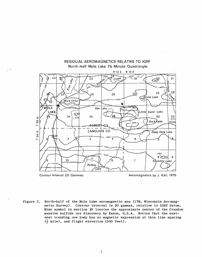
The Wisconsin massive sulfide OCCUI'rences exhibit many similarities to the Noranda-' and Kuroko-type ores, but several differences should be noted. Chief among these is the general lack of a well developed magnetic anomaly which argues against any appreciable content of magnetite or pyrrhotite in the ore body (Figure 3)" This may be a minor difference, but it may indicate either reaction and loss of magnetic minerals during metamorphism, or slightly increased oxygen fugacity in the Middle Precambrian ocean compared to a more reduced environment in the Early Precambrian ocean" Large (1977, Fig. 4 and 5) presents pH-f02,-sulfur concentration diagrams for the iron,",sulfur system at 250° C chosen to represent hydrothermal Ore fluids that may be associated with massive sulfide formation. Except for the lowest total sulfur concentration, an increase in oxygen fugacity results in the loci of ore solutions migrating from pyrrhotite-magnetite stability fields to pyrite or hematite stability fields. Neither pyrite nor hematite have appreciable magnetic susceptibility compared to pyrrhotite and magnetite. Thus, increasing the oxidation potential of the ore solutions, perhaps via mixing with oxygenated sea water, could lead to formation of' nOll'-magnetic minerals, rather than magnetic minerals.
6
z "' '" f--
RESIDUAL AEROMAGNETICS RELATIVE TO IGRF
North-Half Mole Lake 7\1,-Minute Quadrangle
R 13 E
\ _1-------1-_ _ 460 __ � 2
12 7
21
-480
8 i::::J::, 9
Contour Interval 20 Gammas Aeromagnetics by J Karl, 1975
Figure 3. North-half of the Mole Lake aeromagnetic map (17M, Wisconsin Aeromagnetic Survey) .. Contour interval is 20 gammas, relative to IGRF datum. Mine symbol in section 25 locates the approximate center of the Crandon massive sulfide or'e discovery by Exxon, U. S.A. Notice that the eastwest trending ore body has no magnetic expr'ession at this line spacing (� mile), and flight elevation (500 feet).
7

GRADES AND TONNAGES FOR MASSIVE SULFIDE DEPOSITS (after Singer, Cox and Drew, 1975) �� . . \ .\ \
\. • � •
•
� •• :\ •
•
• ' FI:mbeau R
, • e. • . ... ..\.
• • •
• Ie· • . -. . .. . .. -. .. . \ \. --: . . \ S:.�\'�: -: :. \
• �.. .- ·Crandon •
o 01
• •
\ •
TONS OF COPPER
IN DEPOSIT
\ 103
0 1
. . . ... � • Pelican R • •
10 100
MILLIONS OF METRIC TONS OF ORE
10 0
50
20
1 0
05
02
� m :xl l> Gl m () o -u -u m :xl Gl :xl l> o m Z
Figure 4. Ore grades and tonnages for world-wide massive sulfide deposits from Singer, Cox, and Drew (1975)" Diagonal lines represent grade and tonnage relations containing equivalent amounts of copper. The Crandon deposit plots among the larger massive sulfide ore bodies, whereas the Flambeau and Pelican deposits are average to small deposits.
The four identified massive sulfide occurrences in Wisconsin include the Flambeau deposit and the smaller Thornapple deposit of Kennecott, the Pelican River deposit of Noranda, and the Crandon deposit o f Exxon (Table 2 , Fig. 4).
The discoveries of the bodies were by airborne electromagnetic methods ( INPUT). Gravity and magnetic signatures of the three main deposits are somewhat similar (Table 2). Once the regional magnetic field is removed from the total field data ( IGRF), the bodies are found to lie in a magnetic terrane that is -40 to -430 gamma less than background. All of the magnetiC terranes adjacent to the bodies are subdued, with few, if any, IOO-gamma anomalies. Magnetic gradients are 47 to 73 gammas per mile" The Bouguer gravity signature over all of the deposits is ·-35 to -50 milligals, compared to a regional Bouguer gravity for their latitude and elevation of -37 milligals. Gravity gradients are similarly subdued, and range from 1. 0 to 3. 0 per mile. These geophysical data suggest that the host terrane is predominantly felsic to inter-· mediate in composition, with an abundance of volcaniclastic or sedimentary material.
May (1977) and Schwenk (1977) have outlined the known geology and geophysics
8

of the Flambeau deposit near Ladysmith in Rusk County from which the following information is taken. This deposit, presently owned by the Kennecott Copper Corporation, is essentially a verti,cally-oriented, lens'-shaped pod located in Section 9, T. 34 N., R. 6 W. The ore zone is 45-feet wide, 2,300-feet long, and 750,-feet deep. The country rock consists of intermediate to felsic volcanic rocks of andalusite metamorphic grade. The deposit contains 4 to 6 million tons of ore, averaging 3� to 4 percent copper with values in gold and silver, and little zinc. This deposit is unique in that a thick super,· gene enriched crust 300 feet thick is found beneath an Upper Cambrian caprock of sandstone. Economic minerals within the supergene enriched blanket are chalcoci te and bornite which overlies primary chalcopyrite"
The earliest report of possible copper mineralization in the Ladysmith area appeared in Wisconsin Geological and Natural History Survey Bulletin 44 (Hotchkiss, Bean, and Wheelright, 1915). In that Bulletin, the Survey repor'ted that the assay of a sample collected from a well located in Sec. 16, T. 33 N., R. 6 W. , about six miles south of the Flambeau deposit that indicated 1 oz. of silver per ton and 3/4 to 1 percent copper in a "mashed porphyry" that is "very schistose, light--colored, and in many places stained bluish green by copper minerals." The Bulletin goes on to report that "These mineI'al values are not sufficient to make this a workable deposit but judging from the leached appearance of' the rock, there is some chance for greater concentration at depth." The description went essentially unheralded until the 1950's when it was noted by Kennecott Copper Corporation, which began exploring for copper minerals in Wisconsin.
Most of Rusk County is covered by a thick layer of glaCial dr'ift; consequently, geophysical techniques played a prominant role in the exploration program conceived and initiated there in 1966. The original work on three Precambrian exposures was followed by an airborne electromagnetic survey and subsequent ground follow-up. In late May 1967, an airborne EM (Mark V INPtIT@) survey by Geoterrex, Ltd., was flown over a block which incl uded all three prospects that had been identified from the preliminary geologic work. A total of 140 anomalies were recorded. Follow-up ground geophysical surveys and drilling identified a massive sulfide ore body, the Flambeau deposit, and a significantly smaller deposit, the Thornapple, in Section 17, T. 35 N. , R. 6 W"
The wall rocks consist of dacite tuffs and andesite flows" A major and easily recognizable unit is a quartz-·eye schist of unknown thickness believed to have originally been a quartz crystal tuff. The pyroclastic fragments consist predominantly of quartz with highly variable amounts of sericite, plagioclase and cholrite. The last three are less distinctive than the quartz fragments because of more gradational contacts and a composition resembling that of the rock matrix.
A fine-grained, well-foliated and fragmental andalusite-biotite schist forms the hanging wall of the ore horizon. Its thickness is fairly constant along the strike of the deposit, averaging 150 feet. Sulfide mineralization increases towards the are horizon and is found chiefly in the quartz-sericite fragments or as conformable thin lenses within the rock matrix. The other common fragment type consisting of transluscent quartz, probably metachert, tends to be more poorly mineralized.
9

o
Table 2 Identified ?lIiddle Precambrian volcanogenic massive sulfide deIJOslts in Wiscons�n. A small depos�t was found by Kennecott near the Thornapple River in Rusk. County (Sec. 17, T. 35 N., R. 6 W.)
Discovererl
yearl
Locationl
Dimensionsl
Length Width Depth
Size (short tons)l
Grade (average)l
Zinc Copper Gold Silver Lead
Estimated PrOductionl
Ore capacity
PrOjected Start_upl
Hanging Wall
Ore Zone
Foot Wall
Metamorphic Grade
Li tt1e Sand Lake (Crandon)
Exxon, C.S.A.
1976
T. 35 S., R. 12 E. Seco 25
5,000 feet 100
1,650
70 million
-0 o _ 1 present present ore sent
10,000 tod
1986
dacitic to andesltic3
tuffs and breCCias
Flambeau (Ladysmith)
Kennecott Corp.
1968
T. 34 N. , R. 6 W. Sec. 9
2,400 feet 50
800
4-6 million
present 3-k-4%
� 2 0.05 oz/ton 0. 53 oz/ton2
present
1,000 tpd
uncertain
daci tic tuff4
lap111i tuff and3 rhyolitiC lap1lli4
black shale tuff
pyroclastic rnyolitic3 lntermediate tuffs4
breCCla
low greenscnist3
(quartz-albi temuscovite-chlorite subfacies)
ampniboli te4
(andalusitecordierite-a1manditemuscovite subfacies)
Pelican River (Rhinelander)
Noranda Expl.
1974
T. 36 N., R. 10 E. Sec. 29
1,000 feet 50
650
2.2 million
4-�% 1 present present present
uncertain
adesite flows and5
Cherty tuffs
cherty, pyritic fe151(·5
tuffs
cherty felsic tllffs5
with andesite tuffs, breccias and flows
amohibolite5
(sillimanitecordierite-IlIU5covite sUbfacies)

Alteration Prim�H'V
SecOm1tl1,'Y
Age
Aeromagnetics (IGRF)8 Over deposi t Gradient
Bouguer Gravi ty9 Over deposit Gradient Regional
local chloritization3 and ser1citization
alteration Pipe3 not recogn1zed
supergene weathering3 down to 150 feet
1,830 m.v. (approx)6 (Pb/Pb on galena)
-430 gammas 47 g8mmas/mile
-59 mgal 1.0 mgal/mile -37 mgal
serlcitic alteration4
81teration PiPe4 not recogn1zed
extensive supergene4 weather1ng to 150 feet, recognized to 400 feet
1)820 m.y. 7 (Pb/Ph on galena)
-40 ganunas 70 gammas/mile
-35 mgal 1.7 mgal/mile -37 mgal
1 From press releases and testlmony before the Wiscons1n Legislature
intense chloritic5 alteration restricted to channel wa)'s
alteratlon pipe notS readily apparent
not recognized5
1,835 m.y.7 (Pb/Pb on galena)
-120 gammas 70 gammas/mile
-37 mgal 2.9 mgal/mile -37 mgal
2 From EnVironmental Impact Statement for the Flambeau Mine by the Wisconsin Department of Natural Resources
3 From Schmidt and others (1978), and Wisconsin Development and Predevelopment Staff (1978)
4 From May (1977)
5 From Bowden (1978)
6 Age approximate from B. R. Doe, written commun., Feb. 14, 1978
7 From Stacey and others (1976) and Sims (1976)
8 From WisconSln Aeromagnetic Program (Zeitz, Karl and Ostrom, 1978). IGRF refers to the main magnetic field of the earth as tabulated by Fabiano and Peddie (1969). The negative values may be interpreted as a low abundance of magnetic minerals in the immediately adjacent rOCkS, or to reverse magnetic polarization. The magnetic gradients are rather flat, suggesting few units whose magnetic properties are strongly contrasting
9 From the Wisconsin Bouguer Gravity Map compiled by Ervin and Hanuner (1974). The gravity field adjacent to the deposits is either neutral (regional gravity) or slightly negative, suggesting rOCK densities around 2.67 or less. The gravity gradients are reasonably flat suggesting a somewhat homogeneous densi ty distribution near tlle ore deposits
/

A quartz-sericite schist forms the ore horizon gangue. believed to have been a rhyolitic lapilli tuff (May, 1977). for approximately 15,000 feet, and ranges in thickness from mum of approximately 200 feet. Its average thickness where ore body is 115 feet.
This unit is It is tr'aceable
25 feet to a maxi·, it contains the
The ore horizon is a light gray, fine"'grained well-foliated rock having a matrix of quartz (up to 60 percent) and sericite (50 percent) with accessory chlorite, biotite, and andalusite. The felsic ore horizon, being mOl'e eI'osion resistant, forms an area of slight positive relief on the Precambrian subcrop.
There is a distinct change in the volcanic cycle from the felsic ore horizon to the more intermediate footwall rock. Thin units of actinolite and chlorite phyllites and schists either pinch out or are in fault contact with the ore horizon or the quartz·-eye schist. Further away from the deposit, the quartz·,eye schist, as in the hanging wall, becomes the major rock unit.
Intense alteration is present around the Flambeau deposit. No chloritic or brecciated alteration pipe is recognized at Flambeau.. However, metasomatic alterations may have occUITed in a pipe-like zone, the character of which has been destroyed by deformation and metamorphism.
During Late Precambrian time the folded Flambeau volcanic rocks were com-' pletely decomposed by surface weathering to form an impermeable saprolite layer. The sapI'oli te is best preserved under an unaltered outlier of Cambrian sandstone to depths of 5 to 10 feet.
Contact relations between the deposit and the overlying andalusite-,biotite schist are sharp to gradational over a distance of 5 to 15 feet. Pyrite (60 percent) is the chief mineral in the ore horizon with lesser amounts of chal· ' copyrite (12 percent) and sphalerite (2.5 percent). Gold, silver, galena, and pyrrhotite occur in minor quantities. Massive sulfide mineralization (over 50 percent sulfides) predominates in the upper part of the steeply dipping and overturned deposit to 600 feet beneath the subcrop. The east central part of the sulfide deposit contains semi-massive mineralization (20 to 50 percent sulfide), which increases with depth. A disseminated sulfide halo which averages 200 feet in width and contains 7 percent pyrite encloses the massive and semi-massi ve mineralizat ion. The halo extends along strike for at least 5,000 feet in either direction and down-dip for an unknown distance.
The massive sulfide mineralization displays well developed horizontal mineral zoning. The hanging wall tends to be chalcopyri te-,rich with sphalerite noticeably increasing toward the footwall. All of the footwall satellitic lenses are sphaleri te·-'rich. The semi-·massive sulfide mineralizat ion is weakly zoned due to small amounts of widely scattered sphalerite.
Well-developed vertical mineral zoning is displayed in the supergene enriched part of the deposit. Indeed, a classic gossan-oxide-,supergene enriched zoned model has been developed and preseI'ved along most of its strike length. Secondary mineralization is confined to the deposit and the immediate enclosing pyritic halo. The deepest enrichment is found within the massive sulfide parts of the deposit to depths of 180 feet below the subcrop surface. In the east central parts of the deposit, secondary enrichment is restricted to within 80
12

to 100 feet of the subcrop due to lower sulfide content and more impermeable condi tions.
A 16·-foot thick "gossan" of siliceous cap is in sharp contact with massive to semi-massive mineralization. The quartz (90 percent) occurs as massive to vuggy blocks, as angular to subrounded, randomly oriented fragments and as irregular to sugary clasts. Hematite and goethite are the cementing agents .. Overlapping the siliceous cap-secondary sulfide contact is a 3,-foot thick zone of oxidation. This zone is recognized by earthy coatings, specks and botryoidal tenor ite-melanconite , malachite and azurite. In addition, small amounts of cuprite and chalcotrichite occur� Native copper is present as foil or flake coatings on joint surfaces, however, it is more commonly found in thicker sheets away from the deposit near or at the base of the leached cap.
The supergene sulfide mineralization exhibits two distinct zones of approx·imately equal dimensions. The upper chalcocite zone and the lower bor'ni te zone have been developed at the expense of all primary sulfides. The contact between the two zones is gradational.. In the lower zone, numerous reticulating veinlets of bornite replace fracture chalcopyrite. Where this replacement becomes more complete, the veinlets coalesce to form irregular masses of bornite. At the base of the bornite zone, secondary chalcopyrite occurs as botryoidal-, like coatings less than a millimeter thick on primary chalcopyrite or as micro'tetragonal crystals on bornite. The base of the secondary enrichment zone is highly irregular depending on joint control, faulting, primary sulfide permeability and mineral content.
Pelican Deposit
The Pelican deposit of Noranda, east of Rhinelander on the Pelican River in Oneida County is located in Section 29, T. 36 N., R. 9 E. Press releases by Noranda and testimony presented by Noranda management to the Wisconsin legislature document some general details of the ore body. The deposit generally trends east-west for 1000 feet, averages 50 feet wide, and bottoms at about 650 feet. The deposit contain 2. 2 million tons of ore aver'aging 4.5 percent zinc and 1.0 percent copper. In detail, the deposit is divided into a zincrich zone averaging 8 percent zinc and 0.34 percent copper of 1.1 million tons, a copper-rich zone of L8 percent copper and 0.5 per'cent zinc of 0.93 million tons, and a 0.3 million tons zone intermediate in ore grade.
The country rock consists of a 3.5,- to 4-mile wide metavolcanic sequence that is intruded by diorite and granodiorite to the north, and are themselves cut by younger plugs of potassic granite (Schriver, 1973), To the south, a fresh, equigranular to porphyritic pink granite intrudes the metavolcanic rocks (Venditti, 1973). The Pelican deposit is located in the west-central part of this belt. Venditti (1973) and Schriver (1973) interpret this belt as a thick (approximately 10,000 feet) section of potassium-poor tholeiitic basalts that is overlain to the south by dominantly calc-alkaline basalts, andesites, and associated felsic volcanic to volcaniclastic sedimentary rocks. A major fault, the Jump River Fault of Sims, Cannon and Mudrey (1978) separates this sequence from another series of calc-alkaline and tholeiitic basalts farther to the south.
Bowden (1978) has recently studied the petrography and geochemistry of the
13

Pelican deposit in drill COre along a section normal to the east '-west trending, steeply dipping ore body from which the following information is taken. The top of the Pelican deposit is to the south with minor folding complicating the local structure. Evidence for tops to the south include pillows and graded bedding in tuffaceous units, and metal zoning that changes from copper- to zinc- to lead-rich from north to south. Bowden (1978, p.9) divides the Ore body into three informal lithologic units: the hanging wall andesite, the mineralized sequence, and the footwall andesite.
The hanging wall andesite consists of massive to porphyritic, amygdaloidal flows with associated tuffs and tuffaceous sedimentary rocks of similar com-' position, as well as felsic rocks that grade from cherty, black crystal tuffs to massive, black cherts" These chert units are locally banded and pyritic. The flows vary from massive to porphyritic and are generally better preserved than their footwall counterparts.
The mineralized sequence represents a change from dominantly andesitic volcanism to felsic volcanism accompanied by an increase in total sulfide coo,-, tent. Rocks within the mineralized sequence contain a variable mixture by andesi tic and rhyolitic material, cheI't and sulfide minerals. Andesi tic tuffs and tuffaceous sedimentaI'Y I'ocks in the mineralized sequence are mineralogically similar to rooks in the footwall andesite, diffeI'ing for the most par't in the amount of calcite and sulfide minerals present.
Approximately 25 percent of the mineralized sequence is composed of dacitic to rhyolitic tuffs and cherty tuffs in the section studied by Bow<\en (1978)" The remainder of the ore zone is composed of rocks containing varying percent·· ages of chert, sulfide minerals and volc;anic material, with the dominant rock type consisting of alternating layers of Chlori te '-calci te + quar'tz'-pyr 'i te,sphalerite and quartz (chert)-albj.te::: sericite + sphalerite. The chloritic layers are similar to the pyritic andesites, whereas the cherty layers are similar to the felsic tuffs. Approximately 45 percent of the mineralized sequence is composed of these chert·-J sulfide,-rich sediments.
The orebody is zoned, with a footwal,l zone of stockwork ore containing chalcopyri te-pyri te-magneti te under'lying lenses of massive sulfide with a lower zone of pyri te-chalcopyri te-'(sphaleri tel and an upper zone of banded pyri te-,sphaleri te Ore. Major sulfide miner'als consist of pyrite, pyrrhotite, sphalerite and chalcopyrite with minor arsenopyrite, galena, marcasite, magnetite and friebergite (Wiggins and Brett, 1977). Pyrrhotite and magnetite formed dur'ing a later period of metamorphism of the sulfides.
Lenses of ore in lower paI'ts of the mineraliz.ed sequence have been affected by later periods of mineralization. This results in the destruction of monomineralic banding in the pyrite-sphalerite ore with an accompanying formation of veins and anastomosing stringers of chalcopyrite-pyrrhotite in the ore lenses, as well as in the adjacent host rocks. Bowden (1978) interprets this as the effect of a later stage of hydrothermal mineralization on earlier formed ore.
The footwall andesite is composed largely of mafic flows, flow breccia and interflow tuffs, and tuffaceous sedimentary rocks. Primary textures ar'e best preserved in the porphyritic flows. The tuffaceous rocks and breccias are
14

intensely altered, commonly containing stringer are. The tuffaceous sedi,mentary rocks locally are cherty and pyritic. The footwall andesite shows definite hydrothermal alternation in about 60 percent of the core studied.
Rocks of the hanging wall from the Pelican deposit are of lower greenschist metamorphic grade. Rocks from the footwall are more difficult to interpret but also show the effect of low-grade metamorphism, possibly as retrograde products of the higher temperature alteration assemblages formed by mineralizing fluids.
Tuffaceous and sedimentary rocks of the footwall appeal' to be more altered than the massive flows, suggesting that the path of mineralizing fluids was at least partially controlled by the original permeability of the host rocks. Details of alteration are given by Bowden (1978, p. 33) ,
The Crandon deposit of Exxon is located about 10 miles south of Crandon in Forest County near Little Sand Lake in Section 25, T" 35 N., R. 12 E. , and Section 30, T. 35 N. , R. 13 E. The deposit is about 5,000 feet long and trends near east-west, averages 125 feet wide under 125 to 200 feet of glacial deposits, and has been evaluated to about 1,500 feet, although some deep exploration holes have encountered ore to 2,500 feet. The deposit contains reserves of 70 million tons averaging 5 percent zinc and 1 percent copper with substantially lesser values of silver, gold, and lead"
Schmidt and others (1978a, b) and Wisconsin Exploration and Predevelopment Staff (1978) have presented preliminary geologic information on thio:> ore body from which the following information is taken. The deposit is a near-vertical tabular body striking N. 85° W. , consisting of a stratabound massive zone and a stratigraphically underlying stringer zone. It occurs within a sequence of predominatly intermediate and felsic volcanic rocks and their sedimentary derivatives.
Hanging wall rocks consist pr'edominatly of breccias and tuffs. This inter'mediate tuff unit directly overlies the Crandon unit, the mineralized zone. It consists of thin-bedded tuffs and tuffaceous sedimentary rocks of dacitic to andesitic composition. Subordinate lithologies include lapilli-rich tuff, crystal tuff, cherty tuff, shale graywacke, and local calcareous tuff. Graded bedding, flame structures, slump structures and other primary features are present. Several felsic tuff and lapilli tuff beds are interbedded with the intermediate tuff unit and the overlying intermediate breccia unit.
The Crandon unit includes the massive sulfide and its equivalent facies. It is readily identifiable for a distance of 5,000 feet along strike and 2,400 feet below bedrock surface. The thickness varies from 1 foot on the west to 260 feet near the center of the deposit. Three major lithologies dominate: massive sulfide, sulfide-·rich, rhyolite, lapilli tuff, and black shale.
The massive sulfide facies is predominantly pyrite with variable amounts of sphalerite and chalcopyrite and minor amounts of galena, quartz, chlorite, and sericite. The massive sulfide is commonly banded, and in places sulfide clasts, graded bedding and slump features are observed. Sulfide-rich rhyolite
15

lapilli tuff, generally less than 30-,feet thick occurs near the base of the Crandon unit. It is a coarse-grained pyroclastic rock with clasts of rhyolite, cherty rhyolite, and pyrite in a matrix of pyrite, sphaler'ite, and quartz. The black shale facies occurs throughout the Crandon unit as thin, discontinuous lenses above, within, or below massive sulfide, or sulfide-'rich rhyolite tuff.
The footwall breccia is predominantly pyroclastic rhyolitic breccia and subordinate tuff beds. Felsic breccia fragments up to two feet in size are angular to subrounded in a rhyolite matrix of the same composition. Thickness is unknown"
Low greenschist facies metamorphism has affected all rocks except some late gabbroic intrusives. Mineral assemblages are typically of the quartz·'albitemuscovite-chlorite subfacies.
The Crandon ore body consists of a c'onformable and continuous massive sulfide layer partly underla,in by a stringer zone. The massive ore averages 65 feet thick and is 60-90 percent sulfide minerals, pr1.marily pyrite, sphalerite, chalcopyrite, and galena" The massive sulfide zone is irregularly weathered down to 150 feet below the bedrock sUI'face. This zone contains minor amounts of supergene miner'als, such as chalcocite, covellite, bornite, native copper, and native silver. Metal in the massive ore is predominantly zinc, with lesser' values in copper, lead, silver, and gold. The stratigraphic top of the massive sulfide body is sharply defined and closely corresponds to the top of the ore. The base of the "Ore zone, however, is irregular.
The stringer sulfide zone contains evidence of hydrothermal alteration, which is expressed by silica flooding, quartz-siderite,-sulfide veining, chlori tepyrite rims around rhyolite clasts, and patchy zones of very fine grained serici te alteration of rhyolite. The western half of the massive sulfide lens is underlain by stringer sulfide ore containing both contorted and planar quartz,serici te-chlori te-sulfide veIns. About half of the tonnage in the Crandon ore body is stringer ore. Most ore is in apparently conformable breccia units, commonly adjacent to or within 100 feet of the bottom of the massive sUlfide layer. However, stringer ore may be separated from the massive sulfide unit by as much as 700 feet of footwall felsic rocks. Metal content of the stringer ore is predominantly copper, with lesser zinc, lead, Silver, and gold. Sulfide minerals in the stringe,r ore are pyrite, chalcopyri te, s-phaleri te, and minor galena, pyrrhotite, and arsenopyrite.
Review of Northern American Precambr'ian literature (for example, Goodwin, 1977; Fraser and Heywood, 1978) discloses numerous similarities 'of the northern Wisconsin Middle Precambr'ian basin and the LoweI' Precambrian basins of the North American Precambrian Shield. Rock types, basin shapes, and geophysical signatures among other variables permit a first order comparison. Mudrey has analyzed these similarities, and feels that extrapolation from well-studied Lower Precamhri'an basins, such as the Abitibi Basin, to nOI'thern Wisconsin is reasonable alid that the better studied basin may provide some insight into the nature and distribution of ore deposits.
16

One approach is to compare geologically equivalent areas and the distribution in value of identified ore deposits. In the 50, 000 square miles of the Abitibi Basin, 254 deposits have been identified in the last 100 or more years (DeGeoffrey and Wu, 1970), but only 9. 5 percent of 33 deposits have a gross value in excess of the average massive sulfide deposit. This would argue that 66 deposits may exist in the 13, 000 square miles of northern Wisconsin, of which 6 to 7 would be large enough to compa:t'e with an average massive sulfide ore deposit.. Only the Crandon deposit equals or exceeds this size, the Flambeau and Pelican deposits clearly being less than the 10 million ton deposit size of the average massive sulfide. Consideration, of course, should be given to ore grades, tonnages of Ole and recoverable metal. Large amounts of metal may be present in large, low-grade deposits, but these deposits may not be minable at today's prices and technology ..
An alternate approach, and one not well founded to geologic conditions, is the Alph to Zipf approach of FOlinsbee (1977). This method relates the size of the largest deposit to all other deposits of a given kind in a given region" Thus, the largest deposit is twice the size of the second deposit, three times the size of the third deposit, and so forth. The average massive sulfide deposit of the North American shield is about 10 million tons; grading 1. 93 percent copper, 3.85 percent zinc, 0. 88 oz. Silver per ton, 0. 04 oz. gold per ton. Using the Crandon deposit as the largest massive sulfide deposit to be found in northern Wisconsin, seven depOSits may exist lar'ger than the average massive sulfide, the Flambeau deposit and the Pelican deposit would be numbers 18 and 34 respectively.
In the environmental impact report for the Flambeau deposit (Bear Creek Mining Company, 1974) 4, 600 square miles wer·e flown by electromagnetic systems, and 93 INPUT anomalies were identified. Of these, 93 anomalies, 2 massive sul·_· fide deposits were identified, and only 1, the Flambeau deposit, was deemed economic. Inasmuch as the other· deposit, the Thornapple, was initially thought to be due to cultural effects, several of the other 90 anomalies might also be sulfide deposits, and some might be commercial. Using these data for a scaling factor, and recognizing that sui table terrane in the Middle Pr·ecambrian is probably greater than 13,000 square miles as given earlier, it is calculated that 6 to 8 deposits might be found. It is interesting, that these three philOsophically different approaches arrive at essentially the same number of viable deposits.
Massive sulfide deposits generally occur in clusters, reasonably close to each other. Sawkins (in press) identifies that Kuroko-type districts OCcur about 65 miles apart, and the volcanic centers in the Abitibi belt occur about 55 miles apal't.. If one asswnes that the Flambeau, and the Crandon deposits represent two of these centers, perhaps other deposits could be expected at a distance of 50 to 60 miles" Such as area is half way between the two, in Price County. Presently, several exploration programs are centered in that area ..
Mudrey (1978a, b) reviewed the magnitude of the identified massive sulfide occurrences on U. S. zinc and copper reSOurces. Wisconsin presently accounts for 15 percent of identified U. S. zinc reserves. In the past few years, the operating mines in southwest Wisconsin have accounted for' about 2 percent of U. S. zinc production, although in the past 20 years southwestern Wisconsin has ranked fourth in the production of zinc. If the Crandon and Flambeau deposits in northern Wisconsin Come ou--line in the future at the levels pr'oposed, Wisconsin
17

zinc production could account foI' 25 percent of U. S. production. Although land acquisition may prove difficult because of the abundance of small land holdings, severed mineral rights, and lack of mineral rights registration laws,
an enterprising company still has a chance.. It is reasonable to expect that more deposits of massive sulfide ore will be identified in future years in Wisconsin. WhetheI' or not the deposits will be developed will depend on costs, metal prices, environmental constraints at each individual prospect, the tax climate, and the mineral policy of the state.
REFERENCES PTED
Bear Creek Mining Company, 1974, Preliminary Environmental Impact Mining the Flambeau Copper Deposit, Rusk County, Wisconsin: to Wisconsin D·"partment of Natural Resources, 6 volumes.
Report for Submitted
Bowden, D. R., 1978, Volcanic rocks of the Pelican RiveI' Massive Sulfide Deposit, Rhinelander, Wisconsin: A Study in Wall rock Alteration: Unpub. M. S. Thesis, Michigan Technological University, 62 P.
Brooks, C., and Gelinas, L., 1977, The Relationship of Base Metal Mineralization to Chemostratigraphic Divisions in Volcanic Rocks of Canadian Archean Greenstone Belts: IREM-MERI Research Paper 77·-1, 19 p. (MCGill University and Ecole Poly technique de Montreal).
De Geoffroy, J., and Wu, S. M., 1970, A statistical study of ore occurrences in the greenstone belts of the Canadian Shield: Economi.c Geology, v. 65, P. 496-504.
Ervin, C. P.; and Hammer, S. H., 1974, Bouguer anomaly gravity map of Wisconsin: Wisconsin Geological and Natural History Survey Map.
Fabiano, E. B., and Peddie, N. W., 1969, Grid values of total magnetic intensity IGRF--1965: U. S. ESSA Technical Report 38, 55 p.
Folinsbee, R. E., 1977, World' s view�-from Alph to zipf: Geological Society of America Bulletin, 88, P. 897-907.
Fraser, J. A., and Heywood, 1978, eds., Metamorphism in the Canadian Shield: Geological Survey of Canada Paper 78-10, 361 p.
Goodwin, A. M., 1977, Archean basin-craton complexes and the growth of Pre
cambri.an shields: Canadian Journal of Earth Sciences, v. 14, p. 2737-2759.
Hotchkiss, W. O., Bean, E. F., and Wheelwright, O. W., 1915, Mineral land classification: Wisconsin Geological and Natural History Survey, Bulletin 44, 377 P.
18

L'Berge, G. L., and Mudrey, M. G., Jr., 1979, Status framework of the Wisconsin Middle PI'ecambrian:
Report-·-Stratigraphic Wisconsin Geological and
Natural History Survey, Report 79-1, 22 P.
Large, R. R., 1977, Chemical evolution and zonation in volcanic terrains: Economic Geology v'" 72,
of massive sulfide deposits p. 549·-572.
May, E. R., 1977, F lambeau - A PI'ecambrian supergene enriched massive sulfide deposi t: Geosci,ence Wisconsin Vol. 1, P. 1-26.
Mudrey, M. G., Jr'., 1978a, Zinc·-copper resources of Wisconsin: Skillings' Mining Review, v. 67, no. 12, p. 1, 16-19, 28.
Mudrey, M. G., Jr., 1.978b, Wisconsin's Zinc-copper Resources: in Proceedings of the 51st Annual Meeting, Minnesota Section AlME and 39th Annual Minnesota Mining Symposium, p. 22-1-22,-26.
Sangster, D. Canada:
F., 1972, Precambrian volcanogenic massive sulfide deposits A review: Geological Survey of Canada Paper 72-22, 44 P.
Sawkins, F. J., in press, Single stage versus two stage ore deposition in subduction related volcanoplutonic arcs: IAGOD.
in
Schmidt, P. G., Dolence, J. D., Lluria, M. R., and Parsons, G., III, 1978a, Geology of the Crandon Massive Sulfide Deposit in Wisconsin: Skillings' Mining Revi,ew, v. 67, no. 18, Po 1, 8-11.
Schmidt, P. G., Dolence, J. D., Lluria, M. R., and Parsons, G., Geologists block out Exxon's big find of Zn-Cu at Crandon: Mining Journal, July 1978, p. 61-66.
III, 1978b, Engineering/
Schriver, G. H., 1973, Petrochemistry of Precambrian greenstones and granodior'i tes in southeastern Oneida County, Wisconsin: Unpub. M. S. Thesis, University of Wisconsin-,Milwaukee, 83 P.
Schwenk, C. G., 1977, Discovery of the Flambeau deposit, Rusk County, Wisconsin: A Geophysical Case History: Geoscience Wi.sconsin, Vol. I, P. 27-42.
Sims, P. K., 1976, Presidential addr'ess - Precambrian tectonics and mineral deposits, Lake Superior Region: Economic Geology, v. 71, no .. 6, P. 1092-1118.
Sims, P. K., Cannon, W. F., and Mudrey, M. G., Jr'., 1978, PI'eli.minary geologiC map of Precambrian r'ocks in part of northern Wisconsin: U. S. Geological Survey Open-file Report 78-318.
Singer, D. A., Cox, D. P., and Dx'ew, L. J., 1975, Grade and tonnage relationships among copper deposits: U. S. Geological Survey Professional Paper 907-A, 11 p.
19

Stacey, J. S., Doe, B. R., Silver, L. T., and Zartman, R. tectonics IIA, Precambrian Massive Sulfide Deposits. Survey Open-file Report 76-476, 26 p.
E., 1976, Plumbo u. S. Geological
Venditti, A. R., 1973, Petrochemistry of Precambrian rocks in southeastern Oneida County, Wisconsin: Unpub. M. S. Thesis, Ulliversity of WisconsinMilwaukee, 93 p.
Wiggins, L. B., and Brett, R., 1977, Pelican River Cu-Zn Deposit, Wisconsin: Metamorphic Conditions in Penokean Time: Geological Society of America Annual Meeting, Vol. 9, no. 7, P. 1226-1227.
Wisconsin Exploration anf;! Predevelopmep:!: :;Itaff, ],!')78 , The discovery, g'lology, and mineralogy of the Crandon Precambrian massi.ve sUlfide deposit, WiscQnsin (abs.): Geological Society of America Abstracts with Program v. 10, no. 7, p. 518 (Toronto).
Zietz, I., Karl, J. H., and Ostrom, M. E •• ],978. Preliminary aeromagnetic map covering most of the exposed Precambrian terrane in Wisconsin: U. S. Geological Survey Miscellan'lous Field Study MF-888.
20