the morphogenesis of iranian cities*
TRANSCRIPT

THE MORPHOGENESIS OF IRANIAN CITIES*
MICHAEL E. BONINE
ABSTRACT. Traditional Iranian cities have an orthogonal network of streetswhich does not conform to the maze of irregular, twisting lanes postulated for theideal Islamic city. The grid system did not develop from an outgrowth of streetsaround rectangular religious buildings or from the orientation of Iranian housesto maximize seasonal usage, but rather it is due to irrigation systems. The orthog-onal network of water channels corresponds to the slope of the land. Pas-sageways follow these channels to reach various plots of cultivated land. Citieshave expanded along the existing streets and water channels. The basic morphologyof traditional Iranian cities was created by houses filling in adjacent rectangularfields and orchards.
THE concept of the "Islamic City" evolvedfrom the formulations of Orientalists, a
group of scholars versed in the languages andreligions of the Middle East.^ In their viewIslam is an all-encompassing value system
Dr. Bonine is Assistant Professor in the Departmentof Oiiental Studies, University of Arizona, in Tucson,AZ 85721.
* This study was made possible in part by a grantfor research in Iran from the Joint Committee on theNear and Middle East of the American Council ofLearned Societies and the Social Science ResearchCouncil. Preliminary versions of the paper were pre-sented at the 73rd Annual Meeting of the Associationof American Geographers, Salt Lake City, 1977, andthe 11th Annual Meeting of the Middle East StudiesAssociation of North America, New York City. 1977.I am grateful for the comments of my colleagues atthese sessions and to the suggestions and help of Rich-ard W. Bulliet, Richard M. Eaton, Allan D. Haider-man, Robert Hillenbrand, Robert McC. Netting.Michael E. Norvell, Samuel R. Peterson, Richard W.Reeves, Otis W. Templer, and Edmund J. Weber.Special thanks go to Paul Ward English and WilliamR. Royce for their extensive criticisms and advice andto my indefatigable field assistant in Iran, MehdiAbedi.
1 For an excellent discussion of the growth and im-pact of Orientalism see Maxime Rodinson, "The West-ern Image and Western Studies of Islam," in JosephSchacht and Clifford E. Bosworth, eds.. The Legacy ofIslam, 2nd edition (London: Oxford University Press,1974), pp. 9-62. A discussion of the Islamic city withfurther references is found in Michael E. Bonine,"From Uruk to Casablanca: Perspectives on the UrbanExperience of the Middle East," Journal of Urban His-tory. Vol. 3 (1977), pp. 141-80; specifically pp. 148-57, 173-75.
which underlies behavioral patterns and socialorganization and determines the physicalmorphology of settlements. For them the cityis a by-product of Islamic faith and only byunderstanding Islam can one understand thecity. Islam is an urban religion, and by defini-tion "a town was a settlement in which la Mus-lim'sl religious duties and his social idealscould be completely fulfilled."- Because theArabs spread this urban faith, they fostered ur-banism throughout the Middle East. The factthat Bedouin warriors helped to extend thisnew religion into areas which had a long heri-tage of urbanism has not deterred acceptanceof this notion.''
Gustave E. von Grunebaum's influential arti-cle, "The Structure of the Muslim Town," pro-vided a descriptive schema of the Islamic city;it is as perfunctorily quoted as Sjoberg's ThePreindustrial City.^ Relying heavily on earlierFrench Orientalists, von Grunebaum formu-
- Gustave E. von Grunebaum, Islam: Essays in theNature and Growth of a Cultural Tradition (London;Routledge and Kegan Paul, 1955), p. 142. This volumewas originally published as a special issue of TheAmerican Anthropologist, Vol. 57, No. 2, Part 2(April, 1955).
•' For criticisms of the notion that the Arabs fosteredurbanism in the Middle East see Ira M. Lapidus. "TheEvolution of Muslim Urban Society." ComparativeStudies in Society and Historv, Vol. 15 (1973), pp.21-50.
^ von Grunebaum, op. cit., footnote 2, chapter 8,pp. 141-58, originally published as "Die islamischeStadt," Saeculum, Vol. 6 (1955), pp. 138-53; andGideon Sjoberg, The Preindusuial City: Past and Pres-ent (New York; The Free Press, 1960).
ANNALS OF THE ASSOCIATION OF AMERICAN GEOGRAPHERS Vol. 69, No. 2, June 1979© 1979 by the Association of American Geographers. Printed in U.S.A.
208

1979 IRANIAN CiTtEs 209
lated a tnodel of a "full-fledged" Muslim town.''Characteristics of his Islamic city included twocentral institutions—the Friday mosque and themarket—with a hierarchy of trades outwardfrom the mosque, the division of residentialspace into numerous wards or quarters, amaze of twisting streets, and a series of other,less clearly defined features. Recently the en-tire concept of an idealized "Islamic" city hascome into question." But one feature—the mazeof twisting streets—continues to be acceptedas valid even by geographers with considerablefield experience.' In Iran, and particularly inthe central plateau, this commonly accepteddescription of the Middle Eastern urban en-vironment has been misinterpreted.
LABYRINTHS OF TWISTING ALLEYWAYS
The French geographer, Xavier de Planhol,in his The World oj Islam states that "irregu-larity and anarchy seem to be the most strikingqualities of Islamic cities," while Paul WardEnglish has called the labyrinth of twisted al-leys a hallmark of the Islamic city/ The pre-vailing viewpoint is that "the organic, irregularplan . . . is universal in the Muslim world,"and that "Moslem towns grew so spontaneouslyand haphazardly as to prevent the development
•^ The French brothers William and Georges Mar^aiswere inslrumental in formulating the concept of theIslamic city. See William Margais. "L'IsIamisme et lavie iirbaine,"' Conipies-rendus de rAcadt'inie ties In-scriplions el Belies-Leitres (1928), pp. 86-100,reprinted in Mar^ais, Articles et conferences. Puhlica-tion de I'lnstitut d'Etudes Orientales, Faculte des Let-tres d'Alger. No. 21 (Paris: Adrien-Maisonneuve.1961). pp. 59-67; and Georges Mar^ais, "La concep-tion des villes dans l'lslam," Revue J'Al.qer. Vol. 2(1945). pp. M7-33.
'' See A. H. Hoiirani, "The Islamic City in the Lightof Recent Research." in A. H. Hourani and S. M.Stern, eds., The Islamic City: A Colloquium (Oxford:Bruno Cassirer, 1970). pp. 9-24; and Eugen Wirth,"Die orientalische Stadt: Ein Oberblick aufgrund jiin-gerer Forschiingen zur matedellen Kultur," Saecttlitm.Vol. 26 (1975). pp. 45-94.
' Recent exceptions by geographers of this viewpointinclude Wirth, op. cit., footnote 6, pp. 61-74; and PaulWheatley. "Levels of Space Awareness in the Tradi-tional Islamic City." Ekislics, Vol. 253 (1976). pp.354-66; see pp. 362-65.
** Xavier de Planhol, The World of Islam (tthaca:Cornell University Press, 1959), p. 22; and Paul WardEnglish, City ami Village in Iran: Selllement and Econ-omy in the Kirman Basin (Madison: University ofWisconsin Press, 1966), p. 46.
of a systematic street pattern."" Althoughplanned cities existed in the Islamic MiddleEast, these are viewed as geometric exceptionsto the irregular organic town configurations.'"And even these designed cities gradually be-come irregular due to "decadence," and the en-croachment of houses on the public passage-ways."
Iranian cities also are seen as fitting thispattern.^- In Kerman there is a pronouncedirregularity of the street patterns, a "maze ofdark, twisting passageways, alleys, and cul-de-sacs," and "the residential quarters . . . arechaotic; there is no pattern to the lanes."^'' Theold city of Kermanshah is composed of "wind-ing kuchebs laileyways] and numerous cul-de-sacs."^"" Shiraz has "narrow twisting alleys."'^Semnan has winding and narrow alleys, and inHerat "the streets and lanes are narrow and
^ Paul Ward English, "The Traditional City ofHerat, Afghanistan," in L. Carl Brown, ed.. FromMadiiia to Metropolis: Heritage and Change in theNear Eastern City (Princeton: The Darwin Press,1973), pp. 73-90; reference on p. 78; and E. A. Gut-kind, Internationai History of City Development, Vol.8: Urban Development in Eastern Europe: Bulgaria,Romania, and the U.S.S.R. (New York: The FreePress, 1972), p. 395.
'"The classic planned city during Islamic times wasBaghdad. See Jacob Lassner, The Topography ofBaghdad in the Early Middle Ages: Text and Studies(Detroit: Wayne State University Press, 1970). Wirth(op. cit., footnote 6, pp. 61-68) notes a great numberof Islamic and pre-Islamic towns which had beenplanned.
" de Planhol, op. cit., footnote 8, p. 22.'-'Comparative and general discussions of Iranian
street patterns in the Orientalist tradition have beenpublished by German scholars. See, for example, KurtScharlau, "Moderne Unigestaltungen in Grundrissiranischer Stadte," Erdkunde, Vol. 15 (1961), pp.180-91: Helga Anschutz, "Perische Stadttypen: Finevergleichende Betrachtung der Stadte Teheran—^Isfahan—Abadan—Chorramschahr und Buschir inIran." Geographische Rundschau, Vol. 19 (1967), pp.105-10; and K.-G. Gauglitz. "Eigentiimlichkeiten desWegesystems in iranischen Stadten: Die Entstehungvon Gassen und Sackgassen," Orient (Opladen), Vol.10 (1969), pp. 162-69.
'•' English, op. cit., footnote 8, pp. 41-42.'^ John 1. Clarke and Brian D. Clark, Kermanshah:
An Iranian Provincial City (Durham: University ofDurham, Department of Geography, Research PaperSeries. No. 10, 1969). p. 127.
'•̂ John I. Clarke, The Iranian City of Shiraz (Dur-ham: University of Durham. Department of Geogra-phy, Research Paper Series, No. 7, 1963), p. 18.

210 MICHAEL E . BONINE June
twisting, often subterranean, with many sharpturns and frequent cul-de-sacs."^*'
In a discussion of Iranian city plans, dePlanhol stated: 1̂
Except for the timid attempts at modernization byNasr-ed-Din Shah in Tehran in the last third of thenineteenth century, there was not a single street inany Iranian town which ran more than sixty feet ina straight line until Reza Pahlevi assumed the throne[1925], and then suddenly great square grill-worksof streets were imposed on cities as on the tops ofgigantic cakes, with a minimum of consideration foreven the largest complexes of public buildings.
Scharlau echoes the same sentiment, statingthat until Reza Shah's time in almost allIranian towns no main street ran straight, evenfor a short distance.'^
The typical Islamic (and Iranian) city, then,is described as a maze and jumble of twisting,narrow alleyways, a disordered array of darkstreets and blind alleys. Reasons for such chaosrange from the need for protection to the lackof wheeled vehicles.^'' The principal explana-tion, however, has been that cities lack a de-fined status in Islamic law, and thus civilauthorities did not have the capacity to imposea regular plan on the urban environment or toprevent encroachments by private houses uponthe regular network of streets which may havebeen inherited from antiquity.-"
^"Jennifer A. Tavernor and John Connell, "Sem-nan City," in John Connell, ed., Semnan: Persian Cityand Region (London: University College. London, Ex-pedition to Iran. 1969), pp. 17-46; reference on pp.32-33; and English, op. cit.. footnote 9, p. 78. Heratis included in this essay because western Afghanistanis part of the traditional Iranian sphere.
^^de Planhol, op. cit., footnote 8. p. 32.IS Scharlau, op. cit., footnote 12, p. 182.19 de Planhol, op. cit., footnote 8, p. 18; and Rich-
ard W. Bulliet, The Camel and the Wheel (Cambridge:Harvard University Press, 1975).
-"de Planhol, op. cit., footnote 8, pp. 19, 22; vonGrunebaum, op. cit., footnote 2, pp. 149-50; and Eng-lish, op. cit., footnote 8, p. 42. Wheatley (op. cit., foot-note 7, p. 363) surmises that Sauvaget was somewhatresponsible for the prevailing notion of "some anarchicprinciple inherent in Islamic urban evaluation" byshowing how the neat orthogonal Hellenistic lattices inDamascus, Aleppo, and Ladhiqiyah were transformedinto irregular patterns during Islamic times. See JeanSauvaget, "Esquisse d'une hlstoire de la ville deDamas," Revue de Eludes Islamiques. Vol. 8 (1934),pp. 421-80; "Le plan antique de Damas," Syria, Vol.26 (1949), pp. 314-58; Alep: Essai sur le developpe-ment d'une grande ville syiienne, des ori^ines au milieudii XIXe siecle (Paris: Librairie Orientaliste PaulGeuthner, 1941); and "Le plan de Laodicee-sur-Mer,"Bulletin d'Etudes Orientates, Vol. 4 (1934), pp. 81-114.
IRANIAN CITIES: A SPATIAL ALTERNATIVE
In 1898-99 an astute Russian doctor, N.Shetalov, lived in Yazd in central Iran andnoted that in the city "as a general rule, thestreets are not arranged by whimsy, but areoriented in two general directions, to the north-east and to the northwest, crossing at rightangles."-' He stated that there are certainstreets in which he could walk for ten to fifteenminutes essentially in a straight line.--
In contemporary Yazd, a city of approxi-mately 140,000 inhabitants, what at first ap-pears to be confusion in the street plan uponcloser inspection shows a clearly defined pat-tern (Fig. 1). A number of rather straightstreets, some of them more than a kilometer inlength, intersect at right angles. There aremany blind alleys, but they usually are shortand they branch ofi' the longer linear streets atright angles. The long, straight streets are al-most always wider than the shorter ones. Theentire system is basically an orthogonal patternoriented in a northwest-southeast and north-east-southwest direction crossing at right an-gles, as Shetalov had observed. The wide ave-nues built through the city in the twentiethcentury follow the same orientation as the olderlinear streets.
Street plans of other Iranian cities suggestthat the geometry of Yazd is not unique. Thetraditional quarters of Sabzevar, Shiraz, Ker-man, and Ardekan contain similar street pat-terns (Fig. 2). The main streets of Shiraz andKerman are oriented in a northeast or north-west direction; those of Sabzevar and Ardekanare in cardinal directions. The new, wide ave-nues constructed during the rule of Reza Shah(1925-41) essentially parallel the existingstreet pattern and, although some mosques,shrines, bazaars, and residences were sweptaway, destruction was minimized.
The grid network in Yazd and other Iraniancities is clearly not the classic grid pattern townof the Indus, of ancient Greece and Rome, orof modern Western cities.-^ It lacks the rigid
"1 N. Shetalov, "Gorod Iezd," Ohschchestvo Vosto-kovendeniia Sredne-Azialskii Otdet: Sbornik, Vol. 1(1907), pp. 44-197; reference on p. 60 (translation).
-- Shetalov, op. cit., footnote 21, p. 61.-••' See Dan Stanislawski, "The Origin and Spread of
the Grid Pattern Town," Geographical Review, Vol.36 (1946), pp. 105-20; Ferdinando Castagnoli, Or-thogonal Town Planning in Antiquity (Cambridge: TheMIT Press, 1971); and, for example, E. A. Gutkind,

1979 IRANIAN CITIES 211
FIG. 1. Street plan of Yazd. 1) traditional streets and alleyways, widths not to scale; 2)modern avenues, constructed in the Iwentieth century; 3) inner or old city wall, constructed inthe fourteenth century (still mostly standing); 4) outer or new city wall, construction dateunknown but before the nineteenth century (now mostly destroyed); 5) former citadel area(now destroyed). Source: Iraniiin National Cartographic Center, "Yazd" (Scale 1:2.500), 24sheets, 1346 [1967/68]; checked and corrected by the author in the field. Location of walls andgates (open spaces in rhe walls) by field survey, interviews, and the map in Shetalov, op. cit.,footnote 21.
symmetry of such planned cities. Yet there is adistinctly geometric configuration to these Ira-nian cities. The rectangular system of lanes withlong, straight streets is not the labyrinth oftwisting passageways postulated for the Islamic
International History of City Development. 8 vols.(New York: The Free Press, 1964-1972).
city. Several explanations are possible: cultural,climatic, and ecological.
ReiigiotiS PrescriptionsThe orthogonal network of most Iranian
cities is in noncardinal directions. This couldpossibly derive from religious practices, and iftrue, would add a new dimension to the signifi-

212 MICHAEL E . BONINE June
SABZEVAR SHIRAZ
KERMAN ARDEKAN

1979 IRANIAN CITIES 213
cance of Islam in urban structure. Muslimsmust face Mecca when praying and so themihrab or niche of a mosque must face in thedirection (the qihla) of that Holy City.-^ Ira-nian mosques are rectangular with open court-yards and the qibla wall must be to the south-west, in the direction of Mecca.-'' Streets oftenparallel the mosque and the grid systemmight have developed from an extension ofstreets around a mosque—oriented perpen-dicular to and toward the southwest. Even incities founded in pre-lslamic times, whenmosques were later established, the same prin-ciple might apply to nearby, newly establishedquarters.
Such reasoning is not unprecedented. DonaldWilber postulated that two factors influencedthe orientation of Iranian cities in medievaltimes: 1) a major artery between the palaceand the Friday mosque, and 2) the "necessityof turning the mosque so that the qibla wallwould be in the direction of Mecca."-" Else-where in the Middle Hast, de Planhol notesthat in Meknes and Taza (both in Moroccoand Muslim in origin), "one sees more or lessclearly that the streets have been laid out ac-cording to the qibla . . . of the mosque or to itsperpendicular."-^
Directions of traditional linear streets ofIranian cities when compared with the direc-tion to Mecca show limited correspondence(Table I ). Several of the cities, such as Bandar
TABLE 1.—IRANIAN CITIES, DIRECTION TO MECCA ANDDiRF.cTioN OF TRADITIONAL LINEAR STREETS
- 'The milirah is the niche placed in the wall of amosque in the direction of prayer while the qihla tech-nically refers only to the direction of Mecca. How-ever, the latter term also is used for the wall of themosque which has the mihrab. See "kibla," "masdjid."and "mihrab," The Encyclopaedia of Islam. 1st edition.Vols. 2 and 3.
-•"' See, for example, the plans in Arthur UphamPope and Phyllis Ackerman, ed., A Survey of PersianArt: Front Pri'hisloric Times to the Present, Vol. 3(Tokyo: Meiji Shobo, 1964-65 [reprint of the OxfordUniversity Pre5;s edition. 1938-911; and Andre Godard."Les anciennes mosquees de PTran," Athar-e Intii.Vol. 1 (1936). pp. 1S7-:I2.
-''Donald Wither. Contribution on Qazvin, in E. E.Beaiidouin and Arthur Upham Pope, "City Plans." inPope and Ackerman. op. cit., footnote 25. Vol. 3.pp. 1402-04; reference on pp. 1402-03.
- 'de Planhol, op. cit., footnote 8. p. 17.
City
ArdekanBandar AhbasBoshruyehBostamDamghanGonabadIsfahanKashanKashmarKermanKermanshahMa layerMashadNainQazvinQomRafsanjanRezaiyehSabzevarShahrudSemnanShirazTahasTabrizTehranYazdZahedan
Mecca Direction''
S52°WS73''WS 58= WS47°WS40° WS57° WS47° W5 45" WS 55° WS65°WS3rwS34°WS55''WS52° WS36° WS40° WS64°WS20°WS5r wS47°WS40-WS59° WS 56° WS22° WS40''WS57''WS72'W
Linear StreetsPredominant
Direction*^
S 1O°W&S85S7S°W&S85S75''WS 10= WS70° WS35-WComplex5 60° WS30 'WS70'WS 30= WS80° WComplex
S 10° WS35°W&S4OS60= WComplex8 5° WS30° WS65 'WS35''WS 65° WComplex
S35= W&S40S80°W
° w
" W
w° w
' Cities selected on hasis of having city plans available fordeterminins street directions.
'' Bearing, rounded to nearest degree.'^ Bearing, rounded to nearest five degrees, direction estimated
hy author.
Abbas, Kerman, Kermanshah, Nain, and Oom,do have streets similar to the direction of theHoly City, but it is likely that these cities' mainstreets are oriented toward Mecca because ofother factors. Isfahan, Mashad, Rezaiyeh, andTabriz do not have linear streets oriented pre-dominantly in one direction, although indi-vidual sections of these cities have orthogonalstreet networks in various orientations. The lo-cation of the qibla wall and the orientation ofthe mosque appear to have had little influenceon the location and direction of major streets intraditional Iranian cities.
Climaic and Housing Structure
A second possible explanation for geometricstreet plans is climatic; streets might follow the
FIG, 2. Street plans of sections of four Iranian cities. Stippled streets indicate the modernavenues huilt in the twentieth century. Source: Iranian National Cartographic Center,'•Sahzevar." "Shiraz," "Kerman," and "Ardekan-e Yazd" (Scale 1:2,500). 1345-46 (1966/67-67/6S]; the latter map was checked and corrected by the author in the field.

214 MICHAEL E . BONINE June
idir '^rrvPtt pift' i ' .^ k>fe
FIG. 3. Linear streets and linear rows of opencourtyard houses in Yazd.
optimal orientation of the Iranian central pla-teau house. Shetalov believed that Yazd hadlong linear streets because every house wasaligned in one direction to maximize seasonalusage (Fig. 3).-" The houses of Yazd, similarto most of the Middle East, are one-story struc-tures built around an open courtyard and cer-tain sections are inhabited only part of theyear.-'' Enclosed rooms are used in the winterwhile an open vaulted iwan is used in thesummer and the warmer parts of spring andfall (Fig. 4) . During extremely hot summer af-
-8 Shetalov, op. cit., footnote 21. p. 60.-" For plans and further descriptions of typical Ira-
nian houses see Arthur Uph;im Pope, "The SafavidPeriod," in Pope and Ackerman, op. cit.. footnote 25.Vol. 3, pp. 1219-25: Mohsen Moghadam, "An OldHouse in Tehran," idem. Vol. 14, pp. 3193-95; HansE. Wulff. The Tradilional Crafts of Persia: Their De-velopment. Technology, and Influence on Eastern andWestern Civilizations (Cambridge: The MIT Press,1966), pp, 102-35; Rafi Samizay, "Herati Housing ofAfghanistan," Ekistics, Vol. 227 (1974), pp. 247-51:Mary Boyce, "The Zoroastrian Houses of Yazd," inC. E. Bosworth, ed., Iran and Islam: In Memory ofthe Late Vladimir Minorsky (Edinburgh: EdinburghUniversity Press, 1971), pp. 125-47; and Michael E.Bonine, "Aridity and Structure: Adaptations of Indige-nous Housing in Central Iran," in Kenneth N. Clarkand Patricia P. Paylore, eds.. Arid Zone Hoiisiiifi: AnArchiteeturc of Minimums (Tucson: University of Ari-zona Press, forthcoming).
FIG. 4. Open courtyard and vaulted iwan of a tra-ditional Iranian house in Yazd.
ternoons families reside beneath the iwan in acool underground basement, the zirzamin.
To maximize warmth in the winter the en-closed areas need high levels of solar energy;the iwan, on the other hand, should be shadedas much as possible in summer. As a result, theenclosed house is located on the north side togain maximum solar exposure and the iwanis found along the shaded south wall. If onlyone side of the househQld compound were en-closed, a cardinal orientation would maximizethe winter heat and summer shade. But whentwo adjoining sides are enclosed, solar exposureis improved when the house is not oriented in anorth-south direction. Tehran's streets are laidout in cardinal directions, which is explainedby de Planhol by the fact that houses face northto take advantage of the summer breezes com-ing off the Elborz Mountains.'"'
The climatic influence on the internal struc-tures of Iranian houses has not been fully de-termined, but climate can not have been crucialin creating geometric street plans. Whereverstreets within a city vary from the common di-rection, the courtyards vary as well (Fig. 5).What is significant about houses and street pat-terns is that they are oriented in the same di-rection. The streets determine residential pat-terns, not the reverse.
Juhs and Alleys
English analyzed several of the alluvial fanvillages of the Kerman basin.'" These villages.
•'" Xavier de Planhol, "Geography of Settlement," inW, B. Fisher, ed.. The Land of Iran, Vol. 1 of TheCambridge History of Iran (Cambridge: CambridgeUniversity Press, 1968). pp, 409-61; reference onpp. 454-55.
•" English, op. cit., footnote 8, pp. 49-60.

1979 IRANIAN CITIES 215
mm
FIG. 5. Irregular streets and open courtyards ori-ented to the direction of the streets in Yazd.
called linear settlements, are each aligned alonga major watercourse, a juh. This stream is thesurfaced channel of a qanal, a subterraneanconduit which taps water in an alluvial fan ata higher elevation and emerges near settle-ments and cultivated fields.''- The houses arestrung out in a line parallel with the waterchannel. In these villages, which are on steeperslopes than the cities of Kerman or Yazd, thedry wadis which incise the alluvial fans are themajor thoroughfares. Hence some irregularityprevails, and "the linear pattern of householdsbecomes confused in (the lower] part of the set-tlement, because the main watercourses havesplit into numerous smaller channels to irrigatethe wide area of cultivated land below the set-tlement."'^^
There are a number of suburban villages inthe Yazd area that could be described as linear
•'- For descriptions of qanat construction and tech-nology see George B. Cressey, "Qanats, Karez, andFoggaras." Geographical Review, Vol. 48 (1958),pp. 27-44; Hans E. Wiilff. "The Qi\nat% of Iran," Sci-entific American, Vol. 218, No. 4 (April, 1968), pp.94-105: Paul Ward English. "The Origin and Spreadof Qanats in the Old World," Pioceediiif-s of theAmerican Philosophical Society. Vol. 112 (1968),pp. 170-81; and Peter Beaumont, "Qanat Systems inIran," Bullcrii) of the Intemutional Association of Sci-entific Hyclrolof^y. Vol. 16 (1971), pp. 39-50.
••*•' English, op. cit., footnote 8, p. 54.
FjG. 6. Suburban linear village south of Yazd,showing the branching of streets and houses perpendic-ular to the main axis.
settlements. These villages are oriented alongmajor roads and irrigation channels. But un-like the smaller mountain villages, a number ofother streets branch off the main avenues atright angles in these settlements, and housesextend along the side passages (Fig. 6). Sec-ondary jubs branch off from the main channeland run downslope. Perpendicular lanes andhouses also run upslope from the main irriga-tion channel. Houses and fields in such areasare supplied from a different branch of the jubwhich split off at a higher elevation beforereaching the village or, alternatively, by a jubfrom a different qanat. In some instances, sec-ondary channels extend a short distance in theupslope direction, incising ever deeper into theslight grade. As a village expands the housesare built along the linear axis and along the per-pendicular side streets; these thoroughfaresusually are in conjunction with water channels.

216 MICHAEL E . BONINE June
FIG. 7. Yazd and its immediate hinterland. 1) underground qanat channels; 2) contourlines, twenty meter intervals; 3) settlements; 4) major roads and avenues. Source: U.S., ArmyCorps of Engineers, Army Map Service, "Iran" {Scale 1:50,000), Series K753, Edition 1-AMS,Sheet 6853 i, "Yazd," 1966.
But what about the cities? English mentionsthat in Kerman some of the lanes are used aswater channels and these were cobbled overwith small openings every twenty to thirtyyards. At least until the early 1960s thesechannels were the major source of water formost of the population.''* In Herat, Englishnotes that "the alleyways tend to follow slightcontours of the land along which water ischanneled."^•''' Sewage is emptied into the lanesand the channels are needed to wash away thewaste and garbage. In Semnan, the old water
English, op. cit., footnote 8, p. 33.English, op. cit., footnote 9, p. 78.
channels run in the alleyways and this networkof channels was fed by four reservoirs whichwere constructed in the early nineteenth cen-
In Yazd there is an extensive network ofqanat channels beneath the city, often at differ-ent depths. Many of these flow to cultivatedlands around the city or to villages at greaterdistances downslope, but the city dwellers usu-ally had access to this water. Within Yazd thereare almost no open channels in the old alley-
•'" Eamon Murphy, "Water Supply and Urban Agri-culture," in Connell, op. cit., footnote 16, pp. 70-78;reference on pp.

1979 IRANIAN CITIES 217
FIG. 8. Streets and irrigation channels among walled fields in Mehriz. 1) streets and alley-ways, including cul-de-sacs; 2) water channels, shown only in public space and where enteringfields; 3) walled fields and orchards; 4) residential and public buildings; 5) contour lines, onemeter intervals decreasing in elevation to the southeast. Source: Iranian National CartographicCenter, -Mehriz (Yazd)" (Scale 1:2,000). Sheet 5, 1346 [1967/68]; street pattern checked andcorrected, and irrigation channels added by the author in the field; contour lines were inter-polated from spot elevations on an unknown datum.
ways, and it cannot be determined if they ex-isted earlier. However, what is evident is thatthere are a number of qanats which flow toYazd and the direction of these qanats withinthe basin is usually in the same orientation asthe major streets of the city, both being relatedto the slope of the land {Fig. 7 ) . "
Topography afl'ects the orientation of mosttraditional Iranian cities. Orthogonal networksfollow the land surface slope. Hence Kerman,Kermanshah, Oom, and a few other cities haveone axis of their street pattern oriented towardMecca because the direction of slope happensto be congruent (Table I ) . Kermanshah, Oom,and Zahedan even have major wadis whichflow in the same direction as the streets (and
;*" Bulliet also has noted that in medieval Nishapurthe streets were parallel and perpendicular to the slope,the same direction of the qanats and stream beds. SeeRichard W. Bulliet, "Medieval Nishapur: A Topo-graphic and Demographic Reconstruction," StudioIranica, Vol. 5 (1976), pp. 67-89; reference on p. 74.
Mecca). Traditional linear streets in Rezaiyehand Tabriz have no common direction becauseof rough and irregular topography.
Slope is important for the orientation ofstreets and the morphology of Iranian settle-ments because of the water distribution systems.The street network is comprised of linear pas-sages oriented toward or perpendicular to themain slope; water channels are usually asso-ciated with these streets. Which came first?If the water supply system came first the jubsand lanes should conform to the topography,winding and twisting slightly to follow the exactslope of the land. If the street pattern had beenlaid out first, its direction would not neces-sarily relate to the topography. The patternmost frequently observed is an orthogonal net-work oriented toward the slope of the land.
RECTANGULAR FIELDS AND STREET NETWORKS
The familiar rectangular network of streetsis apparent in Mehriz, a dispersed town south-

218 MICHAEL E . BONINE June
FIG. 9. A major irrigation channel and street inMehriz.
east of Yazd (Fig. 8). The main slope is tothe southeast. Although there is a linear groupof houses, the significant feature is that thisintricate, orthogonal pattern of streets, similarto what has been observed in Iranian cities, ispresent without any houses. Long, linear streetsrun in the direction of the main slope, to thesoutheast; other major lanes intersect at rightangles. Smaller perpendicular passages and cul-de-sacs also are present. And this pattern isfound among cultivated fields and orchards!
The field patterns are square or more com-monly rectangular and they run in the samedirection as the streets. Each quadrangle iscomprised of cultivated land which is separatelyowned from adjoining plots, and most are sur-rounded by high mud walls. Water channelsaccompany the major linear streets and evenmost of the smaller ones (Figs. 8, 9, and 10),although some of the minor lanes are used onlyfor access to fields.
The example of Mehriz reveals the significantrelationship between streets, water channels,and walled fields; all are oriented in the samedirection. The major streets have irrigationchannels while smaller passageways provideentry to the walled plots. Wider streets are as-sociated with the main channels and smallerlanes follow the secondary jubs. Hence, a gridnetwork of irrigation channels and streets existsto reach a quadrangular field system—or elsesuch plots are designed to conform to an or-thogonal irrigation distribution. It appears,then, that the rectangular, irrigated walled fieldsare a possible key to the street patterns. Butwhy are plots walled and rectangular?
FIG. 10. A minor irrigation channel and lane (cul-tie-sac) in Mehriz.
Central Plateau Irrigation Practices
Irrigation in the Iranian central plateau isof the border or strip variety.*"' The cultivatedarea is divided into a series of rectangular strips(korts) by low, parallel levees or border ridges(Fig. 11). The korts are constructed with theirlong axis in the direction of greatest slope.Water is diverted into the upper end of eachstrip and then advances downslope in a thinsheet. The size of a kort depends upon the flow
•'** For a discussion of border irrigation see JamesC. Marr. The Border Method of Irriftatiofi. Universityof California, College of Agriculture. Circular 408. nodate; U.S., Department of Interior, Bureau of Recla-mation, Iniffalion Adviser's Guide (Washington, D.C.:U.S. Government Printing Office, 1951), pp, 178-183;and U.S., Department of Agriculture, Soil Conserva-tion Service, Initiation on Western Farms, Agricultureinformation Bulletin No. 199 (Washington, D.C.: U.S.Government Printing Office, 1959).

1979 IRANIAN CITIES 219
FIG. I I ,Iral Iran.
channel exits from the qanat and runs downthe gradient. Hence there is a grid pattern ofchannels parallel and perpendicular to the mainslope—the same directions in which the fieldsrun. Even though the network of channels maybe optimal for irrigating the rectangular fieldsystem, an irrigation system totally conformingto the topography with irregular fields shouldbe more efficient for irrigation. Hence rec-tangular fields and property lines which con-form to the direction of main slope appear to bethe major constraint for the irrigation channels.
Typical reciangiiiar fields or korts in cen- Rectangular Fields and Walled Orchards
of water and infiltration rate of the soil, which,in turn, is related to the degree of slope.'"'
Ideally, the border irrigation system is de-signed so that the required amount of water hasbeen delivered to the field by the time the waterreaches the far end of the strip. Hence, the kortshould be made as large as efficiently possible;if it is too small, time and water are wasteddiverting water from kort to kort; if it is toolarge, too much water is absorbed by the timethe water reaches the end—or else it may notreach the end. Although dimensions of kortsusually are similar within one village, changesin one or more of the variables produce differ-ent sizes of korts in different regions.
Proper leveling and sizing of korts requireskilled labor and planning. The downslope mustbe a gentle, uniform grade to prevent erosionand to spread the water evenly. The cross slope(the width or short axis of the kort) must belevel to prevent the water from fiowing downone side of the strip. Where there is a consider-able incline, as in mountain villages, terracesmay be used in conjunction with the borderstrips. In flatter areas the long axis of the kortsmay run either downslope or else perpendicularto the main slope.
Water is conveyed to the rectangular kortsystem in open ditches or jubs which branchfrom the main irrigation channel. The primary
•'" A more extended discussion of irrigation specifi-cally in Iran can be found in Ann K. S. Lamhton,Lanillord and Peasant in Persia: A Study of LandTenure and Land Revenue Admitiistratiun (London:Oxford University Press, 1953); and Michael E.Bonine, "Traditional Irrigation Systems and Practicesin Central Iran," in Proceedings of the InternationalSeminar on Poptdar Traditions in Iran (Tehran: So-roush Press, forthcoming).
Why are fields and orchards in central Iranso consistently rectangular? It has been recog-nized in West Africa, for example, that themore valuable, private cultivated plots are morerectangular than communal ones, and that pop-ulation pressure may result in intensification ofagriculture and the development of more per-manent and regular field patterns.^" Land sur-rounding Iranian cities is privately owned andthe walled orchards comprise some of the mostvaluable agricultural land. Certainly square orrectangular fields are more conveniently mea-sured than irregular ones which enables suchplots to be taxed more easily or divided forinheritance, selling, or exchange. In Europe,for instance, "wherever the system of inheri-tance permits division of land among heirs,there is a tendency towards strips."'*^
Plowing methods offer few solutions. Nail orscratch plows are used in Iran, which shouldsuggest square fields instead of rectangular ones
•I" See W. B. Morgan, "Farming Practice, SettlementPattern, and Population Density in South-Eastern Ni-geria," The Geographical Journal, Vol. 121 (1955),pp. 320-33; reference on pp. 328-29; and M. B.Gleave and H. P. White, "Population Density andAgricultural Systems in West Africa," in M. F.Thomas and G. W. Whittington, eds.. Environmentand Land Use in Africa (London: Methuen and Co.,1969), pp. 273-300, The topic of agricultural intensityand population pressure has been stimulated especiallyby Ester Boserup, The Conditions of AgriculturalGrowth: The Economics of Agrarian Change tinderPopulation Pressure (London: Allen and Unwin,1965): and one of the more recent statements on thethesis is B, L. Turner II, Robert Q. Hanham. andAnthony V, Portararo, "Population Pressure and Ag-ricultural Intensity," Annals, Association of AmericanGeographers. Vol. 67 (1977), pp, 384-96.
•ii Lynn White. Jr,, Medieval Technology and SocialChange (London: Oxford University Press, 1962),p. 47.
220 June
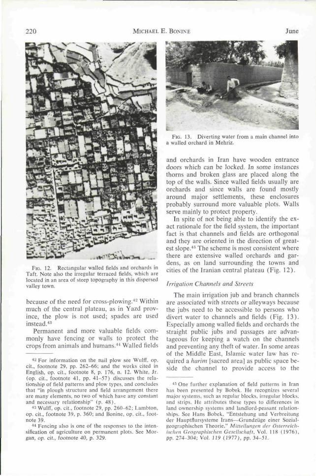
FIG. 12. Rectangular walled fields and orchards inTaft. Note also the irregular terraced fields, which arelocated in an area of steep topography in this dispersedvalley town.
because of the need for cross-plowing.'*^ Withinmuch of the central plateau, as in Yazd prov-ince, the plow is not used; spades are usedinstead.''^
Permanent and more valuable fields com-monly have fencing or walls to protect thecrops from animals and humans.^^ Walled fields
•*2 For information on the nail plow see Wulflf, op.cit., footnote 29, pp. 262-66; and the works cited inEnglish, op. cit., footnote 8. p, 176, n, 12. White, Jr.(op. cit.. footnote 41, pp. 41-57) discusses the rela-tionship of field patterns and plow types, and concludesthat "in plough structure and field arrangement thereare many elements, no two of which have any constantand necessary relationship" (p. 48).
^' Wulff. op, cit,, footnote 29, pp. 260-62: Lambton,op. cit., footnote 39, p. 360; and Bonine, op. cit., foot-note 39.
^* Fencing also is one of the responses lo the inten-sification of agriculture on permanent plots. See Mor-gan, op. cit., footnote 40, p. 329.
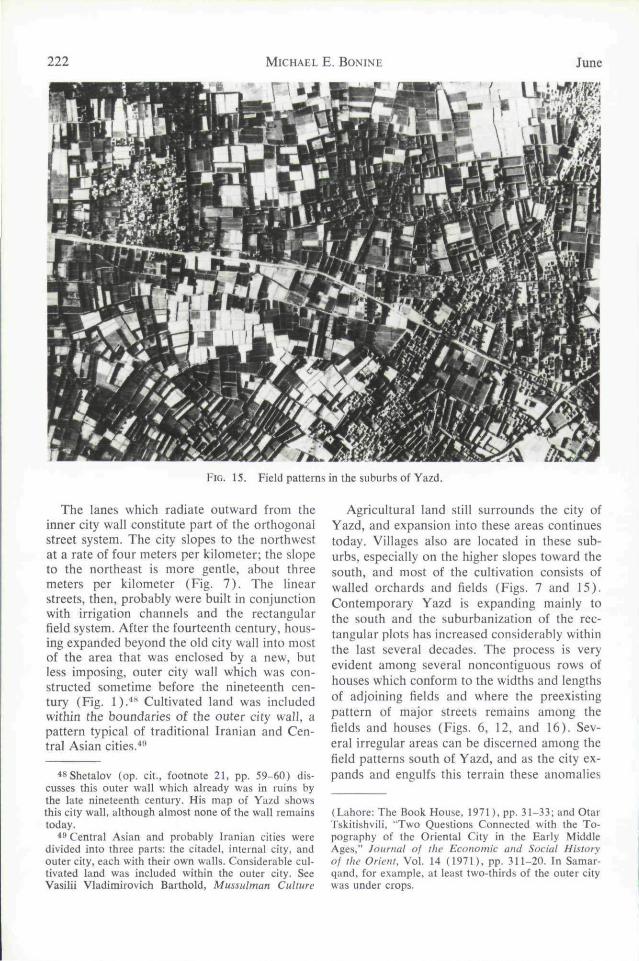
FIG. 13. Diverting water from a main channel intoa walled orchard in Mehriz.
and orchards in Iran have wooden entrancedoors which can be locked. In some instancesthorns and broken glass are placed along thetop of the walls. Since walled fields usually areorchards and since walls are found mostlyaround major settlements, these enclosuresprobably surround more valuable plots. Wallsserve mainly to protect property.
In spite of not being able to identify the ex-act rationale for the field system, the importantfact is that channels and fields are orthogonaland they are oriented in the direction of great-est slope.*" The scheme is most consistent wherethere are extensive walled orchards and gar-dens, as on land surrounding the towns andcities of the Iranian central plateau (Fig. 12).
Irrigation Channels and Streets
The main irrigation jub and branch channelsare associated with streets or alleyways becausethe jubs need to be accessible to persons whodivert water to channels and fields (Fig. 13).Especially among walled fields and orchards thestraight public jubs and passages are advan-tageous for keeping a watch on the channelsand preventing any theft of water. In some areasof the Middle East, Islamic water law has re-quired a harim [sacred area] as public space be-side the channel to provide access to the
*•"> One further explanation of field patterns in Iranhas been presented by Bobek. He recognizes severalmajor systems, such as regular blocks, irregular blocks,and strips. He attributes these types to differences inland ownership systems and landlord-peasant relation-ships. See Hans Bobek, "Entstehung und Verbreitungder Hauptflursysteme lrans-—Grundzijge einer Sozial-geographischen Theorie," Mitteitungen der Osterreich-i.schen Geographischen Gesellschaft. Vol, 118 (1976),pp, 274-304; Vol, 119 (1977), pp. 34-5L

1979 IRANIAN CITIES 221
FIG. 14. Erosion of walls by a water chuiiuc! ::iMehriz.
water.^^ Although the present-day inhabitantsof the central plateau are not aware of any suchprescription, this does not preclude the possi-bility that it once may have been important.
A more practical consideration, however, isthat there must be a space between the wallsand the jub or the mud walls will be erodedaway by the water (Figs. 10, 13, and 14). Thelarger the jub, the greater the distance theremust be between the channel and the wall.Hence wider streets are associated with the mainirrigation channels. A similar utilitarian regardis that individuals and animals cannot walk inthe jubs and the existence of walled fieldslimits public thoroughfares to land alongsidethe channels. The existence of other passageswould waste considerable land. The streetsalong the main channels are more heavily trav-eled and so the wider pathways are mostpractical.
There are, then, a number of factors whichmight contribute to the existence of streets inassociation with water channels and whichwould lead to an orthogonal network of pas-sageways. The question remains as to why street
patterns in cities are similar to those foundamong fields and orchards.
AGRICULTURAL SYSTEMS AND
URBAN MORPHOLOGY
The basic morphology of traditional Iraniancities was created by the expansion of originalcore settlements into adjacent cultivated fieldsand orchards. Rectangular fields surroundingthe settlement already had a system of flood ir-rigation with water channels laid out in a gridpattern which maximized the slope character-istics. Orchards were especially common aroundcities, often owned by members of the urbanelite. The walls around these rectangular plotssuggest an orthogonal street pattern. Houseswere built outside the core settlement alongexisting lanes and water channels, filling in theorchards and cultivated fields. When houseswere constructed in the fields between majorstreets, a few more blind alleys were created toprovide access to the new structures.
Suburban villages also were incorporatedinto an expanding city. Because of the slopecharacteristics and a similar process of growthfor the villages, these settlements often con-formed to the morphology of the city. On theother hand, villages, as field patterns, may beoriented differently when topography varies,and village street networks may become part ofa divergent city structure.
The urban morphology of Yazd reflects ex-pansion into surrounding agricultural areas.The city was established several centuries be-fore Islam as one of the frontier outposts ofthe Sassanian empire (224-641 A.D.), but itremained a small settlement until the fourteenthcentury when the city wall was extended, dou-bling the size of the town.^* Much of this struc-ture, called the inner or old city wall, remainstoday. What is apparent by the location andconfiguration of the wall is that it enclosed acity which already was circumscribed by a gridsystem of roads (Fig. 1). Except for the easternsection near the citadel, the wall conforms tothe predominant direction of the streets.
'" For example, this is the practice in Asir provincein southwestern Saudi Arabia. Personal communica-lion. Michael E. Norvelle, Office of Arid Lands Stud-ies, University of Arizona.
••T Ja'far ibn Mohammad ibn Hassan Ja'fari, Tarikh-e Ynzd [History of Yazd], Text of 15th Century A.D.,ed. by Iraj Afshar (Tehran: BT.N.K., 1960). pp. 29,50-51. A brief account of the evolution of the cityof Yazd can he found in Michael E. Bonine, Yazd andirs HiiuerlamI: A Central Place System of Dominancein the Central Iranian Plateau, unpublished doctoraldissertation, University of Texas at Austin, 1975, pp.16-23.
222 MICHAEL E . BONINE June
FIG. 15. Field patterns in the suburbs of Yazd.
The lanes which radiate outward from theinner city wall constitute part of the orthogonalstreet system. The city slopes to the northwestat a rate of four meters per kilometer; the slopeto the northeast is more gentle, about threemeters per kilometer (Fig. 7) . The linearstreets, then, probably were built in conjunctionwith irrigation channels and the rectangularfield system. After the fourteenth century, hous-ing expanded beyond the old city wall into mostof the area that was enclosed by a new, butJess imposing, outer city wall which was con-structed sometime before the nineteenth cen-tury (Fig. 1).̂ *̂ Cultivated land was includedwithin the boundaries of the outer city wall, apattern typical of traditional Iranian and Cen-tral Asian cities.'*'*
*8Shetalov (op. cit., footnote 21, pp. 59-60) dis-cusses this outer wall which already was in ruins bythe late nineteenth century. His map of Yazd showsthis city wall, although almost none of the wall remainstoday.
•*** Central Asian and probably Iranian cities weredivided into three parts; the citadel, internal city, andouter city, each with their own walls. Considerable cul-tivated land was included within the outer city. SeeVasilii Vladimirovich Barthold, Mussulman Culture
Agricultural land still surrounds the city ofYazd, and expansion into these areas continuestoday. Villages also are located in these sub-urbs, especially on the higher slopes toward thesouth, and most of the cultivation consists ofwailed orchards and fields (Figs. 7 and 15).Contemporary Yazd is expanding mainly tothe south and the suburbanization of the rec-tangular plots has increased considerably withinthe last several decades. The process is veryevident among several noncontiguous rows ofhouses which conform to the widths and lengthsof adjoining fields and where the preexistingpattern of major streets remains among thefields and houses (Figs. 6, 12, and 16). Sev-eral irregular areas can be discerned among thefield patterns south of Yazd, and as the city ex-pands and engulfs this terrain these anomalies
(Lahore: The Book House. 1971), pp. 31-33; and OtarTskitishvili, "Two Questions Connected with the To-pography of the Oriental City in the Early MiddleAges," Journal of the Economic and Social Hislo)yof ihc Orient. Vol. 14 (1971). pp. 311-20. In Samar-qand. for example, at least two-thirds of the outer citywas under crops.

1979 IRANIAN CITIES 223
FIG. 16.Yazd.
Houses filling in fields in the suburbs of
will be rendered into urban morpholoey (Fig,15).
The orthogonal street plans of Sabzevar,Shiraz, Kerman, and Ardekan were formed bysimilar processes.'"' The direction of the linear
-'"Tbe 1:2,000 and 1:2.500 scale maps of Iraniancities produced in the 1960s by the Iranian NationalCarlograpbic Center may be used to see the interrela-tionships of streets, houses, and fields. A number ofthese maps for cities surrounding the Dasht-e Kavirhave been reproduced at smaller scales in Dur Rah-iiozar-e Kavir [Along the Edge of the Desert] (Tehran:Special Office of the Queen of Iran. 1353 [1974/75]).The more readily available city maps by Sahab Geo-graphic and Drafting Institute of Tehran are too gen-eral and inaccurate in most cases for these pur-poses. Although difTicult to find, aerial photographs ofIranian cities also are important for analyzing theseinterrelationships. See Erich F. Schmidt, Flif^lils overAncient Cities of Iran (Chicago: University of Chi-cago Press, 1940); and some of the monographs onindividual Iranian cities cited in Michael E. Bonine,Urbanization and City Structure in Contemporary Iran
Streets conforms to the predominant slope, orits perpendicular, and the urban morphologyresults from expansion into the contiguous agri-cultural land. Tehran's road system is orientedin cardinal directions not due to the cool breezesof the mountains but because water flows di-rectly south from the Elborz.
CONCLUSION
Street systems in Iranian cities were con-structed rationally given the environment andthe preindustrial economy. A grid pattern ofmain streets was established in conjunction witha system of channels used to irrigate agriculturalland. The orientation of this network was de-termined by the need to arrange the rectangularfields and orchards to the slope of the land.Major streets, as well as many blind alleys, al-ready existed within the field patterns beforehouses spread into these areas. Even the sizesand shapes of new suburban houses were gov-erned by the preexisting system of fields andpassageways.
In gradual and uniformly sloping terrain,irrigation channels, streets, and houses are alloriented in this orthogonal configuration. Inirregular topography, jubs, field patterns, andhouses are also irregular. Topography andwater thus constitute the elementary princi-ples of Iranian settlement geography.^'
Contrary to the view postulated by Oriental-ists for the ideal Islamic city, the Iranian cityis not "a tangle of blocks badly ventilated by alabyrinth of twisted alleys and dark courts."•^-There is no need to explain street patterns interms of the tenets of Islam or the preferencesof civil authority. Even though more blind al-leys develop as houses fill in fields betweenmajor streets, this is not symptomatic of "deca-dence." Rather it denotes a reasonable solutionto the practical problem of providing access toa compact assemblage of houses.''^
and Afi;hanisian: A Selected AnnotatedExchange Bibliography, No. 875 (Monticello. Illinois:Council of Planning Libraries. 1975).
•'•' The importance of field patterns, water systenfis.and topography on the morphology of settlements hasbeen recognized. See, for example, Gabriele Schwarz,Al!f,'emeine Siedhingx^cographie (Berlin: Walter deGruyter, 1966). pp. 191-254; however, when discuss-ing the Middle Eastern city, Schwarz reverts to theOrientalists' viewpoint (see pp. 517-20).
•'-de Planhol, op. cit., footnote 8, p. 1.•••^ The development of cul-de-sacs is more compli-
cated within built-up cities, although it is doubtful ifthey result from "some natural or social calamity, a

224 MICHAEL E . BONINE June
Irrigation and agricultural practices, then,play an overriding role in the layout and mor-phology of traditional Iranian cities. One mustbe careful, however, in postulating similar pro-cesses and patterns elsewhere in the MiddleEast. Many cities in this cultural region arebuilt on mounds or tells and other principlesmay influence street networks—although manycities certainly have expanded beyond an orig-inal mound. Street patterns in new garrison androyal cities remain as a problem. Planned citiesin the Islamic Middle East certainly were com-mon, as Wirth has noted.'** The interestingquestion, however, is whether city designs re-sulted from urban planning or whether theydeveloped from planning for irrigation andagriculture systems.
The morphology of traditional Middle East-ern cities needs to be reevaluated. A single
fire, an invasion, epidemic, or other disaster" or repre-sent "a logical expression of certain quasi-religious val-ules inherent in the Muslim way of life" (Wheatley,op. cit., footnote 7, pp. 364-65). Wirth (op. cit.. foot-note 6, pp. 69-75) gives examples of blind alleys de-veloping within built-up areas, both in Islamic and pre-Islamic cities. He also shows several examples ofplanned dead-end streets in North African cities(pp. 70-72). It would he interesting to know what therole of water channels is within these cities.
^* Wirth, op. cit., footnote 6, pp. 61-74.
model for this cultural region—at least theIslamic city model as popularized by vonGrunebaum and de Planhol̂ —-is inadequate.^"^Winters, for example, has shown major differ-ences for the structure of cities in the northcentral Sudan, partly because of elements of aBlack African urban "archetype" but also be-cause the stereotyped model of the Islamic cityis used for comparison.-'^'' Urbanism in this re-gion developed over many millennia, and Islamis only one of the factors which has contributedto the form and structure of Middle Easterncities.
5̂ von Grunebaum, op. cit., footnote 2, pp. 141-58;and de Planhol, op. cit., footnote 8, pp. 1-41.
^''Christopher Winters, "Traditional Urbanism inthe North Central Sudan," Annats, Association ofAmerican Geographers, Vol. 67 {1977). pp. 500-20.The problem of using the stereotyped Islamic citymodel is illustrated by the street patterns. Irregularstreets are given as one of the characteristics of the Is-lamic city by Winters (p. 512). He then stresses that"urbanism in the Sudan did not involve, as it sometimedid in the Middle East, an element of control over . . .the flow of water," and he cites an example of irregu-lar streets in a Sudanese city which followed ravines(p. 519). Streets are irregular in Sudanese cities be-cause the technology of water control was not avail-able and hence in this case irregularity is a character-istic of the Black African urban archetype instead ofthe Middle Eastern archetype!
