the national park service - nps
TRANSCRIPT


THE NATIONAL PARK SERVICE A Brief History
Barry Mackintosh 1999
Any account of the National Park Service must begin with the parks that preceded it and prompted its creation.
The national park concept is generally credited to the artist George Catlin. On a trip to the Dakotas in 1832, he worried about the impact of America's westward expansion on Indian civilization, wildlife, and wilderness. They might be preserved, he wrote, by some great protecting policy of government... in a magnificent park.... A nation's park, containing man and beast, in all the wild and freshness of their nature's beauty!
Catlin's vision was partly realized in 1864, when Congress donated Yosemite Valley to California for preservation as a state park. Eight years later, in 1872, Congress reserved the spectacular Yellowstone country in the Wyoming and Montana territories as a public park or pleasuring-ground for the benefit and enjoyment of the people. With no state government there yet to receive and manage it, Yellowstone remained in the custody of the U.S. Department of the Interior as a national park the world's first area so designated.
Congress followed the Yellowstone precedent with other national parks in the 1890s and early 1900s, including Sequoia, Yosemite (to which California returned Yosemite Valley), Mount Rainier, Crater Lake, and Glacier. The idealistic impulse to preserve nature was often joined by the pragmatic desire to promote tourism: western railroads lobbied for many of the early parks and built grand rustic hotels in them to boost their passenger business.
The late nineteenth century also saw growing interest in preserving prehistoric Indian ruins and artifacts on the public lands. Congress first moved to protect such a feature, Arizona's Casa Grande Ruin, in 1889. In 1906 it created Mesa Verde National Park, containing dramatic cliff dwellings in southwestern Colorado, and passed the Antiquities Act authorizing presidents to set aside historic and prehistoric structures, and other objects of historic or scientific interest in federal custody as national monuments. Theodore Roosevelt used the act to proclaim 18 national monuments before he left the presidency. They included not only cultural features like El Morro, New Mexico, site of prehistoric petroglyphs and historic inscriptions, but natural features like Arizona's Petrified Forest and Grand Canyon. Congress later converted many of these natural monuments to national parks.
By 1916 the Interior Department was responsible for 14 national parks and 21 national monuments but had no organization to manage them. Interior secretaries had asked the Army to detail troops to Yellowstone and the California parks for this purpose. There military engineers and cavalrymen developed park roads and buildings, enforced regulations against hunting, grazing, timber cutting, and vandalism, and did their best to serve the visiting public. Civilian appointees superintended the other parks, while the monuments received minimal custody. In the absence of an effective central administration, those in charge operated without coordinated supervision or policy guidance.
The parks were also vulnerable to competing interests, including some within the ascendant conservation movement. Utilitarian conservationists favoring regulated use rather than strict preservation of natural resources advocated the construction of dams by public authorities for water supply, power, and irrigation purposes. When San Francisco sought to dam Yosemite's Hetch Hetchy Valley for a reservoir after the turn of the century, the utilitarian and preservationist wings of the conservation movement came to blows. Over the passionate opposition of John Muir and other park supporters, Congress in 1913 permitted the dam, which historian John Ise later called the worst disaster ever to come to any national park.
Hetch Hetchy highlighted the institutional weakness of the park movement. While utilitarian conservation had become well represented in government by the U.S. Geological Survey and the Forest and

Reclamation services, no comparable bureau spoke for park preservation in Washington. Among those recognizing the problem was Stephen T. Mather, a wealthy and well-connected Chicago businessman. When Mather complained to Secretary of the Interior Franklin K. Lane about the parks' mismanagement, Lane invited him to Washington as his assistant for park matters. Twenty-five-year-old Horace M. Albright became Mather's principal aide upon Mather's arrival in 1915.
Crusading for a national parks bureau, Mather and Albright effectively blurred the distinction between utilitarian conservation and preservation by emphasizing the economic value of parks as tourist meccas. A vigorous public relations campaign led to supportive articles in National Geographic, The Saturday Evening Post, and other popular magazines. Mather hired his own publicist and obtained funds from 17 western railroads to produce The National Parks Portfolio, a lavishly illustrated publication sent to congressmen and other influential citizens.
Congress responded as desired, and on August 25, 1916, President Woodrow Wilson approved legislation creating the National Park Service within the Interior Department. The act made the bureau responsible for Interior's national parks and monuments, Hot Springs Reservation in Arkansas (made a national park in 1921), and such other national parks and reservations of like character as may be hereafter created by Congress. In managing these areas, the Park Service was directed to conserve the scenery and the natural and historic objects and the wild life therein and to provide for the enjoyment of the same in such manner and by such means as will leave them unimpaired for the enjoyment of future generations.
Secretary Lane named Mather the Park Service's first director and Albright assistant director. A policy letter Lane approved in 1918 elaborated on the bureau's dual mission of conserving park resources and providing for their enjoyment. While reemphasizing the primacy of preservation, it reflected Mather's and Albright's conviction that more visitors must be attracted and accommodated if the parks were to flourish. Automobiles, not permitted in Yellowstone until 1915, would be allowed throughout the system. Hotels would be provided by concessionaires. Museums, publications, and other educational activities were encouraged as well.
The policy letter also sought to guide the system's expansion. In studying new park projects, you should seek to find scenery of supreme and distinctive quality or some natural feature so extraordinary or unique as to be of national interest and importance, it directed. the national park system as now constituted should not be lowered in standard, dignity, and prestige by the inclusion of areas which express in less than the highest terms the particular class or kind of exhibit which they represent
Through the 1920s the national park system was really a western park system. Only Acadia National Park in Maine lay east of the Mississippi. The West was home to America's most spectacular natural scenery, and most land there was federally owned and thus subject to park or monument reservation without purchase. If the system were to benefit more people and maximize its support in Congress, however, it would have to expand eastward. In 1926 Congress authorized Shenandoah, Great Smoky Mountains, and Mammoth Cave national parks in the Appalachian region but required that their lands be donated. With the aid of John D. Rockefeller, Jr., and other philanthropists, the states involved gradually acquired and turned over most of the land needed for these parks in the next decade.
But the Park Service's greatest opportunity in the East lay in another realm that of history and historic sites. Congress had directed the War Department to preserve a number of historic battlefields, forts, and memorials there as national military parks and monuments, beginning in 1890 with Chickamauga and Chattanooga National Military Park in Georgia and Tennessee. After succeeding Mather as director in 1929, Albright was instrumental in getting Congress to establish three new historical parks in the East under Park Service administration. Colonial National Monument, Virginia, which included Yorktown Battlefield, and Morristown National Historical Park, New Jersey, the site of Revolutionary War encampments, edged the Park Service into the War Department's domain.

Soon after Franklin D. Roosevelt took office in 1933, Albright accompanied the new president on a trip to Shenandoah National Park and mentioned his desire to acquire all the military parks. Roosevelt agreed and directed Albright to initiate an executive transfer order. Under the order, effective August 10, 1933, the Park Service received not only the War Department's parks and monuments but the 15 national monuments then held by the Forest Service as well as the national capital parks, including the Washington Monument, Lincoln Memorial, and White House. The addition of nearly 50 historical areas in the East made the park system and Park Service truly national and deeply involved with historic as well as natural preservation.
As Roosevelt launched his New Deal, the Park Service received another mission: depression relief. Under its supervision the Civilian Conservation Corps employed thousands of young men in numerous conservation, rehabilitation, and construction projects in both the national and state parks. The program had a lasting impact on the Park Service. Many professionals hired under its auspices remained on the bureau's rolls as career employees, and regional offices established to coordinate CCC work in the state parks evolved into a permanent regional system for park administration.
During the 1930s the Park Service also became involved with areas intended primarily for mass recreation. Begun as depression relief projects, the Blue Ridge Parkway between Shenandoah and Great Smoky Mountains national parks and the Natchez Trace Parkway between Nashville, Tennessee, and Natchez, Mississippi, were designed for scenic recreational motoring. In 1936, under an agreement with the Bureau of Reclamation, the Park Service assumed responsibility for recreational development and activities at the vast reservoir created by Hoover Dam. Lake Mead National Recreation Area, as it was later titled, was the first of several reservoir areas in the park system. In 1937 Congress authorized Cape Hatteras National Seashore, the first of several seashore and lakeshore areas.
Albright left the Park Service for private business in 1933 and was succeeded by his able associate director, Arno B. Cammerer. Newton B. Drury, who had directed the Save-the-Redwoods League in California, followed Cammerer in 1940. America's entry into World War II a year later forced Drury to preside over a drastic retrenchment in Park Service activity and defend the parks against pressures for consumptive uses in the name of national defense. Timber interests sought Sitka spruce in Olympic National Park for airplane manufacture. Ranchers and mining companies pressed to open other parks to grazing and prospecting. Scrap drive leaders eyed historic cannon at the Park Service's battlefields and forts. Drury successfully resisted most such demands, which eased as needed resources were found elsewhere.
The postwar era brought new pressures on the parks as the nation's energies were redirected to domestic pursuits. Bureau of Reclamation plans to dam wilderness canyons in Dinosaur National Monument in Colorado and Utah touched off a conservation battle recalling Hetch Hetchy. Interior Secretary Oscar L. Chapman's decision to support the project contributed to Drury's resignation in March 1951. But this time the park preservationists won: Congress finally declined to approve the Dinosaur dams.
Conrad L. Wirth, a landscape architect and planner who had led the Park Service's CCC program, became director in December 1951. Facing a park system with a deteriorating infrastructure overwhelmed by the postwar travel boom, he responded with Mission 66, a ten-year, billion-dollar program to upgrade facilities, staffing, and resource management by the bureau's fiftieth anniversary in 1966. A hallmark of Mission 66 was the park visitor center, a multiple-use facility with interpretive exhibits, audiovisual programs, and other public services. By 1960, 56 visitor centers were open or under construction in parks from Antietam National Battlefield Site, Maryland, to Zion National Park, Utah.
Mission 66 development, criticized by some as overdevelopment, nevertheless fell short of Wirth's goals in large part because the Park Service's domain kept expanding, diverting funds and staff to new areas. Congress added more than 50 parks to the system during the ten-year period, from Virgin Islands National Park to Point Reyes National Seashore in California. Expansion continued apace under George B. Hartzog, Jr., who had superintended the Jefferson National Expansion Memorial in St. Louis before

succeeding Wirth in 1964. Under his leadership through 1972, the Park Service and system branched out in several new directions.
Natural resource management was restructured along ecological lines following a 1963 report by a committee of scientists chaired by A. Starker Leopold. as a primary goal, we would recommend that the biotic associations within each park be maintained, or where necessary recreated, as nearly as possible in the condition that prevailed when the area was first visited by the white man, the Leopold Report declared. A national park should represent a vignette of primitive America. Environmental interpretation, emphasizing ecological relationships, and special environmental education programs for school classes reflected and promoted the nation's growing environmental awareness.
Living history programs became popular attractions at many historical parks, ranging from frontier military demonstrations at Fort Davis National Historic Site, Texas, to period farming at Lincoln Boyhood National Memorial, Indiana. The Park Service's historical activities expanded beyond the parks as well. Responding to the destructive effects of urban renewal, highway construction, and other federal projects during the postwar era, the National Historic Preservation Act of 1966 authorized the bureau to maintain a comprehensive National Register of Historic Places. Listed properties publicly and privately owned, locally as well as nationally significant would receive special consideration in federal project planning and federal grants and technical assistance to encourage their preservation.
Several new types of parks joined the system during the Hartzog years. Ozark National Scenic Riverways in Missouri, authorized by Congress in 1964, foreshadowed the comprehensive Wild and Scenic Rivers Act of 1968, which led to the acquisition of other free-flowing rivers. On the Great Lakes, Pictured Rocks and Indiana Dunes became the first national lakeshores in 1966. The National Trails System Act of 1968 made the Park Service responsible for the Appalachian National Scenic Trail, running some 2,000 miles from Maine to Georgia. Gateway National Recreation Area in New York City and Golden Gate National Recreation Area in San Francisco, both established in 1972, were precedents for other national recreation areas serving metropolitan Cleveland, Atlanta, and Los Angeles.
During the bicentennial of the American Revolution in the mid-1970s, the two dozen historical parks commemorating the Revolution benefited from another big development program. At Independence National Historical Park in Philadelphia the Park Service reconstructed the house where Thomas Jefferson drafted the Declaration of Independence, installed elaborate exhibits at the site of Benjamin Franklin's house, and moved the Liberty Bell to a new pavilion outside Independence Hall. On July 4, 1976, President Gerald R. Ford, once a seasonal ranger at Yellowstone, spoke at Independence Hall and signed legislation making Valley Forge a national historical park.
Four years later, the Alaska National Interest Lands Conservation Act of 1980 more than doubled the size of the national park system by adding over 47 million wilderness acres. The largest of the new areas in Alaska, Wrangell St. Elias National Park, comprises more than 8,300,000 acres, while the adjoining WrangellöSt. Elias National Preserve comprises nearly 4,900,000. Together they cover an area larger than New Hampshire and Vermont combined and contain the continent's greatest array of glaciers and peaks above 16,000 feet. The national preserve designation was applied to ten of the new Alaska areas because they allowed certain activities, like sport hunting and trapping, not permitted in national parks.
Russell E. Dickenson, a former park ranger and manager, took the helm in 1980. Because the Park Service's funding and staffing had not kept pace with its growing responsibilities, Dickenson sought to slow the park system's expansion. The Reagan administration and the Congress that took office with it in 1981 were of like mind. Rather than creating more parks they backed Dickenson's Park Restoration and Improvement Program, which allocated more than a billion dollars over five years to resources and facilities in existing parks.
William Penn Mott, Jr., a landscape architect who had directed California's state parks when Ronald Reagan was governor, followed Dickenson in 1985. Deeply interested in interpretation, Mott sought a

greater Park Service role in educating the public about American history and environmental values. He also returned the bureau to a more expansionist posture, supporting such additions as Great Basin National Park, Nevada, and Steamtown National Historic Site, a railroad collection in Scranton, Pennsylvania. Steamtown, championed by Scranton's congressman for its local economic benefits, was a costly venture much criticized as an example of park barrel politics, but Mott was convinced of its educational potential.
James M. Ridenour, formerly head of Indiana's Department of Natural Resources, served as director during the Bush administration (1989ö1993). Doubting the national significance of Steamtown and other proposed parks driven by economic development interests, he spoke out against the thinning of the blood of the national park system and sought to regain the initiative from Congress in charting its expansion. He also worked to achieve a greater financial return to the Park Service from park concessions. In 1990 the Richard King Mellon Foundation made the largest single park donation yet: $10.5 million for additional lands at the Antietam, Gettysburg, Fredericksburg, and Petersburg Civil War battlefields, Pecos National Historical Park, and Shenandoah National Park.
Roger G. Kennedy, who had directed the Smithsonian Institution's Museum of American History, was the Clinton administration's choice to head the Park Service in 1993. Like Mott, he was especially concerned about expanding the bureau's educational role and sought to enlarge its presence beyond the parks via the Internet. His tenure coincided with a government-wide effort to restructure and downsize the federal bureaucracy, which accelerated after the Republicans took control of Congress in 1995. The Park Service restructured its field operations and embarked on a course of reducing its Washington and regional office staffs by 40 percent.
In 1997 Robert Stanton became the first career Park Service employee since Dickenson to head the bureau. Beginning as a ranger, he had most recently served as regional director of the National Capital Region. An African American, Stanton took particular interest in increasing the diversity of the Park Service to better serve minority populations.
As of 1999 the national park system comprises 379 areas in nearly every state and U.S. possession. In addition to managing these parks as diverse and far-flung as Hawaii Volcanoes National Park and the Statue of Liberty National Monument the Park Service supports the preservation of natural and historic places and promotes outdoor recreation outside the system through a range of grant and technical assistance programs. Major emphasis is placed on cooperation and partnerships with other government bodies, foundations, corporations, and other private parties to protect the parks and other significant properties and advance Park Service programs.
Public opinion surveys have consistently rated the National Park Service among the most popular federal agencies. The high regard in which the national parks and their custodians are held augurs well for philanthropic, corporate, and volunteer support, present from the beginnings of the national park movement but never more vital to its prosperity.
BIBLIOGRAPHY Albright, Horace M., and Robert Cahn. The Birth of the National Park Service: The Founding Years, 1913–33. Salt Lake City: Howe Brothers, 1985.
Albright, Horace M, and Marian Albright Schenck. Creating the National Park Service: The Missing Years. Norman: University of Oklahoma Press, 1999.
Dilsaver, Lary M., ed. America's National Park System: The Critical Documents. Lanham, MD: Rowman & Littlefield, 1994.
Everhart, William C. The National Park Service. Boulder, CO: Westview Press, 1983.

Foresta, Ronald A. America's National Parks and Their Keepers. Washington: Resources for the Future, 1985.
Hartzog, George B., Jr. Battling for the National Parks. Mt. Kisco, NY: Moyer Bell, 1988.
Hosmer, Charles B., Jr. Preservation Comes of Age: From Williamsburg to the National Trust, 1926–1949. 2 vols. Charlottesville: University Press of Virginia, 1981.
Ise, John. Our National Park Policy: A Critical History. Baltimore: Johns Hopkins Press, 1961.
Mackintosh, Barry. The National Parks: Shaping the System. Washington: National Park Service, 1991.
Rettie, Dwight F. Our National Park System: Caring for America's Greatest Natural and Historic Treasures. Urbana: University of Illinois Press, 1995.
Ridenour, James M. The National Parks Compromised: Pork Barrel Politics and America's Treasures. Merrillville, IN: ICS Books, 1994.
Rothman, Hal K. Preserving Different Pasts: The American National Monuments. Urbana: University of Illinois Press, 1989.
Runte, Alfred. National Parks: The American Experience. 3d ed. Lincoln: University of Nebraska Press, 1997.
Shankland, Robert. Steve Mather of the National Parks. 3d ed. New York: Alfred A. Knopf, 1976.
Sellars, Richard West. Preserving Nature in the National Parks: A History. New Haven: Yale University Press, 1997.
Swain, Donald C. Wilderness Defender: Horace M. Albright and Conservation. Chicago: University of Chicago Press, 1970.
Wirth, Conrad L. Parks, Politics, and the People. Norman: University of Oklahoma Press, 1980.

1summary...
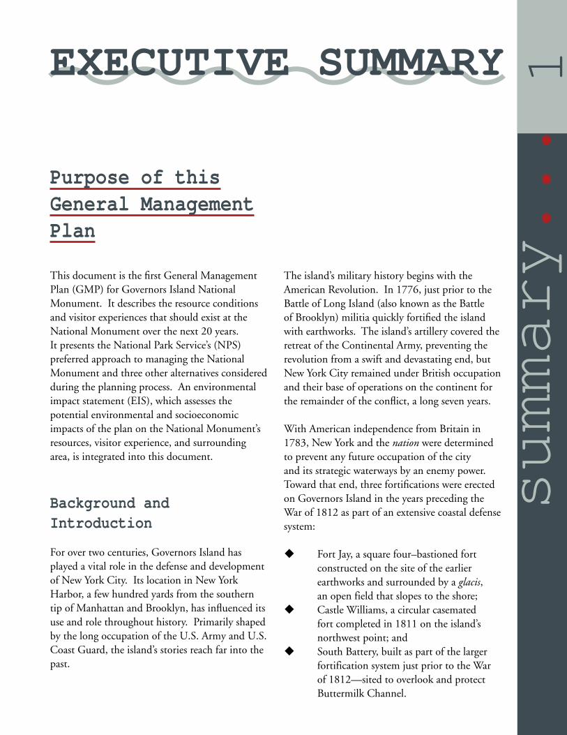
Purpose of this General Management Plan
This document is the fi rst General Management Plan (GMP) for Governors Island National Monument. It describes the resource conditions and visitor experiences that should exist at the National Monument over the next 20 years. It presents the National Park Service’s (NPS) preferred approach to managing the National Monument and three other alternatives considered during the planning process. An environmental impact statement (EIS), which assesses the potential environmental and socioeconomic impacts of the plan on the National Monument’s resources, visitor experience, and surrounding area, is integrated into this document.
Background and Introduction
For over two centuries, Governors Island has played a vital role in the defense and development of New York City. Its location in New York Harbor, a few hundred yards from the southern tip of Manhattan and Brooklyn, has infl uenced its use and role throughout history. Primarily shaped by the long occupation of the U.S. Army and U.S. Coast Guard, the island’s stories reach far into the past.
The island’s military history begins with the American Revolution. In 1776, just prior to the Battle of Long Island (also known as the Battle of Brooklyn) militia quickly fortifi ed the island with earthworks. The island’s artillery covered the retreat of the Continental Army, preventing the revolution from a swift and devastating end, but New York City remained under British occupation and their base of operations on the continent for the remainder of the confl ict, a long seven years.
With American independence from Britain in 1783, New York and the nation were determined to prevent any future occupation of the city and its strategic waterways by an enemy power. Toward that end, three fortifi cations were erected on Governors Island in the years preceding the War of 1812 as part of an extensive coastal defense system:
Fort Jay, a square four–bastioned fort constructed on the site of the earlier earthworks and surrounded by a glacis, an open field that slopes to the shore;Castle Williams, a circular casemated fort completed in 1811 on the island’s northwest point; andSouth Battery, built as part of the larger fortification system just prior to the War of 1812—sited to overlook and protect Buttermilk Channel.
EXECUTIVE SUMMARY

2...summary
Castle Williams and Fort Jay are among the best remaining examples of early American coastal fortifi cations.
During the Civil War, Governors Island held Confederate prisoners of war and Union deserters, with offi cers held in Fort Jay and enlisted men in Castle Williams. The army opened a recruiting station on the island, and troops from the island responded to the 1863 draft riots in New York City. After the war, Castle Williams was used as a military stockade and became the East Coast counterpart to military prisons at Fort Leavenworth, Kansas, and Alcatraz Island, California.
In 1878 the military installation on the island, then known collectively as Fort Columbus, became a major Army administrative center. By 1912, the Army had expanded the island from about 70 acres to 172 acres by adding landfi ll from New York City’s subway construction. The post became headquarters of the United States First Army in 1939. The island continued to serve as an important shipment center during World Wars I and II. When the Army left in 1966, the island became home to the largest U.S. Coast Guard base in the world.
In 1985 the northern 121 acres of the island, with 62 historic structures in a campus–like landscape, were designated a National Historic Landmark District. The base’s closing in 1996 concluded almost two centuries of the island’s use as a federal reservation.
On January 19, 2001, President William J. Clinton established the Governors Island National Monument by Presidential Proclamation 7402. The monument consisted of Castle Williams, Fort Jay and a portion of the surrounding Parade Ground. The monument, however, remained subject to Public Law 105-33, section 9101, 111 Stat. 670 (August 5, 1997), which required the entire island, including the monument lands, to be sold with a right of fi rst offer to the State and City of New York.
As a result, subsequent actions were taken on January 31, 2003:
The State and City of New York each executed a consent and waiver of the right of first offer regarding Governors Island; A 22 acre portion of Governors Island was sold to the National Trust for Historic Preservation;The remainder of Governors Island (150 acres) was sold to the Governors Island Preservation and Education Corporation (GIPEC).The National Trust relinquished and conveyed their 22 acre parcel to the United States of America and was accepted by the Secretary of the Interior.
On February 7, 2003, President George W. Bush issued Proclamation 7647, which included additional facilities within the monument boundaries, referenced the previous proclamation and legal island transfers, and described the basic purpose of the monument and role of the NPS.
Since Summer 2003, NPS has offered guided and self-guided tours of the National Monument and surrounding historic district and, in collaboration with GIPEC, has sponsored public programs and special events on the island. NPS and GIPEC are securing public funds to maintain, repair and rehabilitate their respective historic structures and, guided by the transfer documents, are cooperating in the development of Governors Island for the benefi t of the people of New York and the United States.
This Draft General Management Plan (GMP) sets forth a vision for the development and operation of Governors Island National Monument. Like the creation of the National Monument itself, this vision is the product of a process that integrates the aspirations of the public with the unique capabilities of the NPS to provide for the preservation and public enjoyment of the National Monument over the next 20 years.

3summary...
National Parks of New York Harbor
Governors Island National Monument is one of the parks within the National Parks of New York Harbor (NPNH), an initiative the NPS created to enhance the identity, visibility, and public support for the parks in the New Jersey–New York metropolitan area. Its mission includes collaboration with other parks and organizations in the area in the care and appropriate use of all historic, recreational, and natural resources, and to promote the national park system.
Foundation for Planning
The “Foundation for Planning” for the National Monument expresses the purpose and signifi cance of the National Monument, its key interpretive themes, and other critical guidance for managing the unit, such as the Quitclaim Deed of Transfer, that specifi es conditions the NPS and GIPEC must comply with in managing and redeveloping the island. It defi nes many of the critical parameters for the GMP and subsequent plans.
Purpose Governors Island National Monument was established to preserve and protect Castle Williams and Fort Jay and to interpret them and their role in the defense of New York Harbor and the nation. The island provides an opportunity to educate the public about the evolution of coastal defense and military communities as well as the harbor’s rich history and ecology.
Signifi canceGovernors Island has long been a strategic location in one of the country’s most important harbors. The National Monument includes two of the fi nest examples of defensive structures from the First and Second American Systems of Coastal Fortifi cations. The surrounding National and New York City Historic Landmark District, and the greater island provide the context for understanding the evolution—over more than two centuries—of American defensive strategies and the growth of the U.S. Army as a professional federal force. The forts’ historic defensive technologies and proximity to and views of Lower Manhattan present an opportunity to The National Parks of New York Harbor.

4...summary
refl ect on the events of September 11, 2001.
Governors Island’s forts highlight the Second American System that constructed a dozen defensive structures around New York Harbor, and up and down the East and West Coasts. As part of this harbor defense system, Governors Island’s forts have been credited as successfully deterring British forces from attacking New York during the War of 1812. Fort Jay is an enclosed square fortifi cation of French design with four bastions and a ravelin, surrounded by a dry moat and glacis. Constructed over remnants of earlier British and Continental Army earthworks on the island’s highest point, Fort Jay is one of the largest and best preserved examples of its kind in the country. Castle Williams is a nearly circular red sandstone and granite fortifi cation commanding the island’s northwest point, merely 600 feet from the walls of Fort Jay. The Castle is the fi rst American–designed fort with casemated gun emplacements, and its innovative design served as a prototype for seacoast fortifi cation for decades.
Later in the 19th–century, their original defensive designs obsolete, the forts served new purposes—primarily as barracks and prisons—as Governors Island grew to become one of the most important military headquarters in the eastern United States, continuing these functions through the Army’s departure in 1966, and to the end of the Coast Guard’s tenure in 1996.
Key Interpretive Themes
Connecting people to places is the role of interpretation. Interpretive themes provide the broad framework for all interpretive programming, such as public tours, park publications and special events. The themes are derived from a park’s purpose and capture the essence of its signifi cance. Interpretation reveals meaning, and interpretive themes link universal, human experiences that transcend time and culture with a park’s stories and tangible resources.
Place in the National Experience Castle Williams and Fort Jay on Governors Island represent an important early effort to protect and defend the country through a system of strategically placed coastal fortifi cations, an effort that continued beyond the life of the forts until the end of the island’s military career.
Place in the Local and World Communities New York City’s emergence as a nationally and internationally important city elevated Governors Island’s stature, command, and responsibilities, offering those stationed on the island enormous infl uence on local and global issues.
Place in the Environment Governors Island—as part of the natural environment of New York Harbor, with its rich and intricate ecosystem of bays, estuaries, rivers, islands, and other geographical features—is an ideal place to observe and study the important role that natural systems and humans play in the development and evolution of New York Harbor and surrounding metropolis.
5summary...
Special Mandates
Proclamations made by Presidents William J. Clinton (2001) and George W. Bush (2003) established the National Monument and provide the fundamental direction for its operation—to preserve and protect the historic forts for the benefi t of present and future generations. A Quitclaim Deed of Transfer contains specifi c guidance for the National Monument and the rest of the island. The deed also binds the NPS and GIPEC to the Governors Island Preservation and Design Manual which was developed by the U.S. General Services Administration (GSA) in consultation with the New York City Planning Department, the New York City Landmarks Preservation Commission, the New York State Offi ce of Parks Recreation and Historic Preservation, the Advisory Council on Historic Preservation, and the National Trust for Historic Preservation.
Fundamental Resources and Values
The historic fortifi cations, Fort Jay (1794–1809) and Castle Williams (1807–1811), including their associated features such as the glacis and covered defi le (below grade walkway), are the National Monument’s most prominent fundamental resources. They are outstanding examples of First and Second American Systems of Coastal Fortifi cations. The forts are listed individually as New York City and National Historic Landmarks. Fundamental resources also include archeological resources and the cultural landscape, which extend beyond the boundary of the National Monument and include the surrounding 121-acre National Historic Landmark District designated in 1985.
Summary of the Alternatives
Based on the Foundation for Planning, and in consideration of public interests expressed during the planning process, several management alternatives were developed. All construction and staffi ng proposals in the alternatives are contingent on NPS funding limitations and priorities, and would be implemented over the life of the General Management Plan. Alternative D—Harbor Partnership has been identifi ed as the NPS preferred alternative and the environmentally preferred alternative, as defi ned by NPS policy and the National Environmental Policy Act.
Alternative A—No ActionNPS continues current management practices and plans with no major new actions.
This alternative refl ects current park management practices and establishes a baseline for the comparison of all other alternatives, as required by the National Environmental Policy Act (NEPA).
NPS would preserve its dock and historic buildings and grounds and provide for public enjoyment of the National Monument based on existing federal laws, regulations, and policies. As funds become available, the NPS would:
Repair and maintain the National Monument’s dock, historic structures and cultural landscape to stabilize and prevent further degradation of these resources and to remove public safety hazards;Abate hazardous materials in the forts to permit safe and healthy access to their courtyards and interior spaces by staff, maintenance contractors and visitors;

6...summary
Demolish Buildings S-251 and 513 and Parking Area 504 to remove non-essential and unhealthy and unsafe structures; Landscape demolition areas; Install a floating dock to provide for guaranteed access to the National Monument for emergency, operational and visitor purposes.
Public programming and access would remain limited in the short-term with seasonal interpretive and educational programs. As funding becomes available and over time, the NPS would expand the season to allow visitors year-round access to the cultural landscape and eventually fort interiors after hazmat abatement.
Ferry transportation to the National Monument and larger island would continue to be provided by GIPEC and private ferry operators. The NPS would continue existing agreements with GIPEC and other organizations for operations, public programs and long-term planning.
Common to All “Action” AlternativesThe “Action” alternatives—B, C, and D—share numerous objectives and would seek to accomplish the following broad goals:
Preserve the National Monument’s historic resources for the enjoyment of present and future generations. Management would make historic preservation of Fort Jay and Castle Williams its highest priority.
Right: Conceptual rendering of NPS actions under all action alternatives: Castle Williams is rehabilitated as the island’s exhibition and history center; building, courtyard and roof are open for programs and public use year-round. By Peter Roper.

7summary...

8...summary
Offer visitors multiple and varied opportunities to explore and understand the National Monument. Public access to the National Monument would be convenient and affordable. Dock 102 would have a new contact station which would serve as an information and orientation center; Building 140 would continue to be another welcoming center with a bookstore.
Operate the National Monument as part of the larger island. The NPS would cooperate with organizations, including GIPEC, to make Governors Island an educational and civic resource of special historic character, and a recreational and open–space resource for the people of New York and the United States.
In each alternative, the combination of preservation and programming activities would make the National Monument a major New York City and Harbor attraction, drawing local visitors back repeatedly and drawing national and international audiences.
Alternative B—The History CenterDevelop the Governors Island History Center located in Castle Williams and Fort Jay.
In addition to the common actions, the NPS would rehabilitate historic Castle Williams, Fort Jay and the cultural landscape, permitting visitors and NPS staff access to all areas of the National Monument. Visitor services and experiences would be concentrated within the National Monument boundary.
The Governors Island History Center would act as the focal and starting point for visitors exploring the island’s history. The History Center would be located in Fort Jay and Castle Williams, and offer a variety of activities.
Castle Williams would host regular and changing programs, permanent and temporary exhibits, audiovisual presentations, lectures and special events. Visitors could explore the fort’s massive casemates, peer through cannon embrasures, and climb to the rooftop for stunning views of New York Harbor.
Visitors could recreate on Fort Jay’s expansive glacis, explore special features of the fort, such as the ammunition magazine, and visit barracks that refl ect the offi cers’ and enlisted men’s domestic lives.
Visitors would explore the National Monument on their own or through ranger–led tours. The National Monument’s key themes would be interpreted from the perspective of the forts, using these powerful and tangible elements as the jumping–off point for telling the island’s history. As in all the alternatives, visitors could explore other parts of the island on their own.
Alternative C—Island Collaborative Develop a range of activities in the National Monument’s historic forts and at key locations—interpretive nodes—around Governors Island in coordination with on- and off-island partners.
NPS interpretive and educational programming would be coordinated with

9summary...
other activities offered to visitors on the island. Working in close cooperation with GIPEC, island tenants, and other organizations, the NPS would develop an island–wide system of “interpretative nodes”—information stations which may include kiosks, waysides and other interpretive media—that refl ect the National Monument’s key themes, important information and orientation. These nodes would be located at all island ferry landings, along paths and at key locations of interest. Ranger–led tours of the forts and historic district would supplement these self–guided explorations.
In this alternative, rehabilitation activities by NPS would focus on the forts’ exteriors, basic infrastructure and key interior features. To help meet its goals for preservation, the NPS would establish leases with compatible nonprofi t organizations, who would rehabilitate and occupy some portions of Fort Jay and Castle Williams. However, the NPS would retain those key portions of the forts necessary for year-round public programming, visitor access and park operations.
Alternative D—The Harbor Center (the NPS Preferred Alternative)Develop the National Monument as the Harbor Center—a hub of activities and jumping off point for visitors wanting to explore New York Harbor.
Working with other harbor-related organizations—national parks and local, regional, national and international civic, educational and research organizations—the NPS would develop a range of activities in Fort Jay and Castle Williams
that interpret the key themes of the island and greater harbor. The park would collaborate and coordinate on harbor–related programs on and off Governors Island that would help visitors understand the forts’ military signifi cance, the island’s strategic location, and the ongoing ecological conservation efforts for the harbor and the re-visioning and re-development of the waterfront.
The Monument would become a primary stop on harbor ferry tours. Programs could include specialized boat tours of the harbor, educational programs that explore the harbor’s history and ecology.
A variety of programs, exhibits, and special events would be available in both forts. These activities would use the harbor to describe the island’s history and signifi cance, and the interplay over time between the harbor and the city’s health and economy.
Fort Jay could house harbor research, offi ces and temporary lodging for NPS-sponsored fellowship and residency programs; and be the setting for harbor-related seminars and workshops.
Castle Williams would be the island’s main exhibit and interpretive center, showcasing multimedia programs and interactive exhibits that explore local, national, and global topics associated with Governors Island and New York Harbor.

10...summary
Summary of Estimated Costs to Implement the Alternatives
Three categories of costs are estimated for each alternative: one–time capital, recurring (annual and periodic), and life–cycle. More detailed descriptions of these categories are in Chapter 2. These fi gures are for planning and comparison purposes only and represent gross costs. The fi gures are in 2006 dollars.
It is anticipated that any capital improvements, staff and operational costs will be phased over the life of this plan. The implementation of the approved plan will depend on future funding and Servicewide priorities. The approval of a GMP does not guarantee that funding and staffi ng needed to implement the plan will be forthcoming. Full implementation of the GMP could be many years into the future.
Environmental Consequences of the Alternatives
This GMP describes the affected environment—the existing natural, cultural and socioeconomic resources that would be affected either directly or indirectly by implementation of any of the alternatives—and evaluates the consequences of implementing those alternatives. Impact topics eliminated from further analysis because they are not present in the Governors Island National Monument, or will not be affected by any of the alternatives, include prime and unique agricultural lands; vegetation; wetlands; fl oodplain and 100–year coastal fl ood; wild and scenic rivers; wildlife and their habitats; rare, threatened, endangered or special–concern species and their habitats; geology, topography and soils; ethnography and ethnographic resources; Indian Trust resources; environmental justice; soundscape and noise management; lightscape/night sky; and National Monument non–historic resources, which include Building S–251, and Building 513, and Dock 102; historic resources not within the National Monument; and traffi c, parking and transportation.
Summary of Costs (in millions, rounded to nearest million)
A: No–Action B: The History Center C: Island Collaborative
D: The Harbor Center (Preferred)
One–time Capital $12 - 15 $46 - 56 $38 - 46 $50 - 60
Recurring (over 25 years) $6 - 7 $10 - 13 $10 - 12 $11 - 13
Life–Cycle $55 - 66 $95 - 114 $94 - 112 $107 - 128

11
summary...
Impact topics that have been retained for further analysis include cultural resources within the National Monument: historic structures, the cultural landscape, archeological resources, and collections and archives; natural resources: air quality, water quality, aquatic life and their habitats; the visitor experience; administration and operation; and the socioeconomic environment.
A summary of the environmental consequences of the alternatives is provided in the table below.
Next page: Revolutionary War Re-enactment, Summer, 2006 on the glacis. Daniel C. Krebs.
Summary of Environmental Consequences
A: No Action Common to All Action Alternatives
B: The History Center
C: Island Collaborative
D: The Harbor Center (Preferred)
NEPA/106 NEPA/106 NEPA/106 NEPA/106 NEPA/106
Historic Structures
minor benefi cial impacts / no adverse effect
moderate benefi cial impacts / no adverse effect
moderate benefi cial impacts / no adverse effect
moderate benefi cial impacts / no adverse effect
moderate benefi cial impacts / no adverse effect
Cultural Landscape
minor adverse impacts / no adverse effect
moderate benefi cial impacts / no adverse effect
moderate benefi cial impacts / no adverse effect
moderate benefi cial impacts / no adverse effect
moderate benefi cial impacts / no adverse effect
Archeological Resources
negligible to minor adverse impacts / no adverse effect
minor to moderate adverse impacts / adverse effect
minor to moderate adverse impacts / adverse effect
minor to moderate adverse impacts / adverse effect
minor to moderate adverse impacts / adverse effect
Collections and Archives
minor adverse effect / no adverse effect
moderate to major benefi cial impacts / no adverse effect
major benefi cial impact / no adverse effect
major benefi cial impacts / no adverse effect
major benefi cial impacts / no adverse effect
Air Quality negligible negligible negligible negligible negligible
Water Quality minor negative short–term / minor benefi cial long–term
minor negative short–term / minor benefi cial long–term
minor negative short–term / minor benefi cial long–term
minor negative short–term / minor benefi cial long–term
minor negative short–term / minor benefi cial long–term
Aquatic Life and Their Habitats
minor negative short–term / negligible benefi cial long–term
minor negative short–term / negligible benefi cial long–term
minor negative short–term / negligible benefi cial long–term
minor negative short–term / negligible benefi cial long–term
minor negative short–term / negligible benefi cial long–term
Visitor Experience minor to moderate adverse short–term / minor to moderate benefi cial long–term
minor adverse short–term / major benefi cial long–term minor adverse
short–term / major benefi cial long–term minor adverse
short–term / major benefi cial long–term minor adverse
short–term / major benefi cial long–term
Administration and Operation (increase/decease)
minor increase major increase major increase major increase major increase
Socioeconomic Environment
negligible benefi cial minor benefi cial minor benefi cial minor benefi cial minor benefi cial
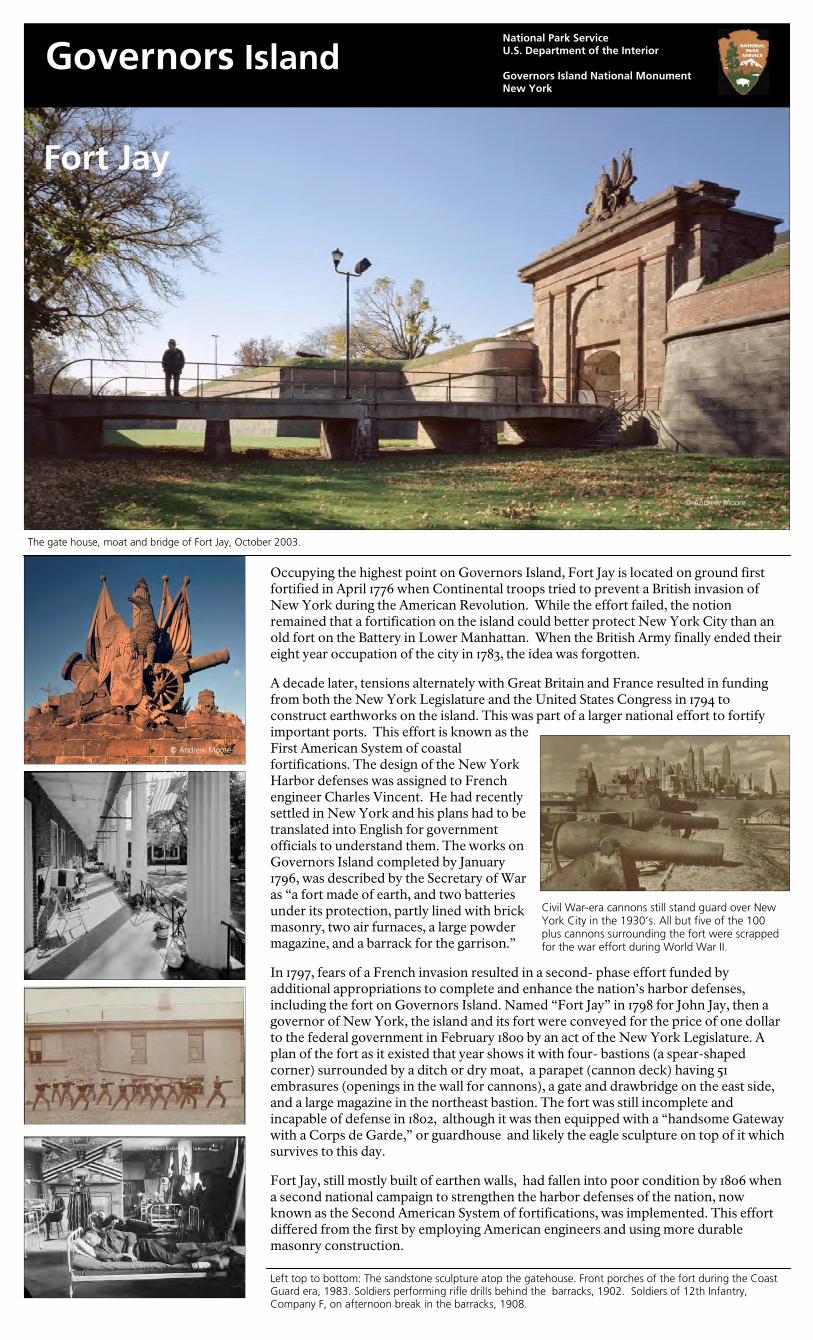
Fort Jay
Governors Island National Park Service U.S. Department of the Interior Governors Island National Monument New York
Occupying the highest point on Governors Island, Fort Jay is located on ground first fortified in April 1776 when Continental troops tried to prevent a British invasion of New York during the American Revolution. While the effort failed, the notion remained that a fortification on the island could better protect New York City than an old fort on the Battery in Lower Manhattan. When the British Army finally ended their eight year occupation of the city in 1783, the idea was forgotten. A decade later, tensions alternately with Great Britain and France resulted in funding from both the New York Legislature and the United States Congress in 1794 to construct earthworks on the island. This was part of a larger national effort to fortify important ports. This effort is known as the First American System of coastal fortifications. The design of the New York Harbor defenses was assigned to French engineer Charles Vincent. He had recently settled in New York and his plans had to be translated into English for government officials to understand them. The works on Governors Island completed by January 1796, was described by the Secretary of War as “a fort made of earth, and two batteries under its protection, partly lined with brick masonry, two air furnaces, a large powder magazine, and a barrack for the garrison.” In 1797, fears of a French invasion resulted in a second- phase effort funded by additional appropriations to complete and enhance the nation’s harbor defenses, including the fort on Governors Island. Named “Fort Jay” in 1798 for John Jay, then a governor of New York, the island and its fort were conveyed for the price of one dollar to the federal government in February 1800 by an act of the New York Legislature. A plan of the fort as it existed that year shows it with four- bastions (a spear-shaped corner) surrounded by a ditch or dry moat, a parapet (cannon deck) having 51 embrasures (openings in the wall for cannons), a gate and drawbridge on the east side, and a large magazine in the northeast bastion. The fort was still incomplete and incapable of defense in 1802, although it was then equipped with a “handsome Gateway with a Corps de Garde,” or guardhouse and likely the eagle sculpture on top of it which survives to this day. Fort Jay, still mostly built of earthen walls, had fallen into poor condition by 1806 when a second national campaign to strengthen the harbor defenses of the nation, now known as the Second American System of fortifications, was implemented. This effort differed from the first by employing American engineers and using more durable masonry construction.
The gate house, moat and bridge of Fort Jay, October 2003.
Civil War-era cannons still stand guard over New York City in the 1930’s. All but five of the 100 plus cannons surrounding the fort were scrapped for the war effort during World War II.
Left top to bottom: The sandstone sculpture atop the gatehouse. Front porches of the fort during the Coast Guard era, 1983. Soldiers performing rifle drills behind the barracks, 1902. Soldiers of 12th Infantry, Company F, on afternoon break in the barracks, 1908.
© Andrew Moore
© Andrew Moore
The engineer chosen to design and oversee the defenses of New York Harbor was Colonel Jonathan Williams, Chief Engineer of the Corps of Engineers, first Superintendent of the Military Academy at West Point and grand-nephew of Benjamin Franklin. Reconstruction of Fort Jay, now renamed Fort Columbus for political reasons, began in July 1806 and completed by December 1809. According to an engineering assessment by Colonel Williams in a November 1808 report, the only components of the old fort judged worth saving and that exist today were “the walled counterscarp”—the outer wall of the moat and the gate. The completed fort was described to Congress as “an enclosed pentagonal work, with four bastions of masonry, calculated for one hundred guns, fifty- five mounted, with brick barracks for two hundred and thirty men, including officers. [And] a stone and brick magazine….” Also constructed at this time was Castle Williams, a circular defensive work made of red sandstone that was erected on the west point of the island between 1807 and 1811. The quadrangle of barracks that exist today were constructed about 1833. During the Civil War, the fort was a prison for Confederate officers whose diaries tell of the activities that occupied their imprisonment (baseball, writing a newspaper or burying the soldiers under their command who were dying of measles in Castle Williams). From 1878 to 1921, it housed an Army music and bandmasters school. In the 1930s, the barracks were remodeled into housing for junior army officers and their families. Possessing the feel of a friendly townhouse apartment complex, it was fondly remembered as a wonderful military home for generations of army and later, coast guard dependents. It remained family housing until the departure of the U.S. Coast Guard in 1996. Fort Jay was listed in the National Register of Historic Places in 1974. It was included in a National Historic Landmark District designated in 1985, and a New York Historic District designated in 1996. The fort is now part of the Governors Island National Monument.
E X P E R I E N C E Y O U R A M E R I C A 7-620
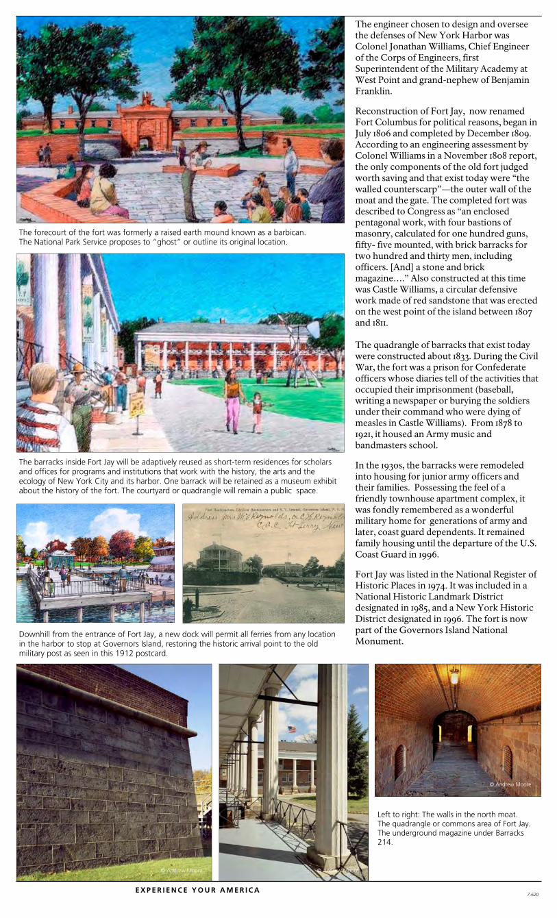
The forecourt of the fort was formerly a raised earth mound known as a barbican. The National Park Service proposes to “ghost” or outline its original location.
The barracks inside Fort Jay will be adaptively reused as short-term residences for scholars and offices for programs and institutions that work with the history, the arts and the ecology of New York City and its harbor. One barrack will be retained as a museum exhibit about the history of the fort. The courtyard or quadrangle will remain a public space.
Downhill from the entrance of Fort Jay, a new dock will permit all ferries from any location in the harbor to stop at Governors Island, restoring the historic arrival point to the old military post as seen in this 1912 postcard.
Left to right: The walls in the north moat. The quadrangle or commons area of Fort Jay. The underground magazine under Barracks 214.
© Andrew Moore
© Andrew Moore © Andrew Moore

Castle Williams
Governors Island National Park Service U.S. Department of the Interior Governors Island National Monument New York
Castle Williams is a circular defensive work of red sandstone on the west point of Governors Island in New York Harbor. It was designed and erected between 1807 and 1811 under the direction of Colonel Jonathan Williams, Chief Engineer of the U.S. Army Corps of Engineers . The castle was one component of a defensive system for the inner harbor that included Fort Jay and the South Battery on Governors Island, Castle Clinton at the tip of Manhattan, Fort Gibson (at Ellis Island) and Fort Wood (now the base for the Statue of Liberty). Its usefulness as a fortification began to end in the 1830’s and afterwards it served as barracks for the garrison, new recruits and transient troops. During the Civil War Castle Williams served alternately as a barracks for troops headed to war and as a prison for Confederate soldiers and deserters from the Union Army. In 1895, Castle Williams was designated as a military prison. In 1901, Secretary of War, Elihu Root who worked hard to modernize the Army also made a commitment to preserve the castle and overruled army leaders who wanted to demolish both it and Fort Jay. By 1903, the castle was fitted up as a model, state-of-the-art prison facility. In 1947, extensive renovations were carried out with the wooden catwalks replaced by concrete enclosed walk ways, hiding the beautiful stone arches on the third level and resulting in the industrial appearance of the courtyard today. Castle Williams ceased operations as a military prison in 1965 just before the U.S. Army left Governors Island. The castle again faced a demolition challenge as Coast Guard officials in Washington, D.C. who took over Governors Island in 1966 wanted to demolish it. Instead, the it was remodeled as a youth community center with a nursery, meeting rooms for Scouts and clubs, a woodworking shop, art studios, a photography laboratory, and a museum. By the late 1970’s the community center moved to another location and the fort became the grounds keeping shop for the Coast Guard base. Over time the roof failed and broken windows allowed serious water damage to occur inside the castle. In the mid-1990’s, the roof was replaced and new windows stopped further water damage to the structure, but the interior remains closed until it can be made safe for public access. The National Park Service proposes to stabilize and restore the castle and eventually provide access to the roof, allowing the public to admire the harbor and the modern skyline of the great city this fortress once protected.
© Andrew Moore © Andrew Moore © Andrew Moore
Jonathan Williams learned military engineering while helping his great uncle, Benjamin Franklin, in France during the 1770’s. Returning to America, he employed his own ideas to classic military fortification design, making the castle a pioneering effort in American fortifications design. Today, named after its designer, Castle Williams it is the best preserved of its type in the country and is featured in the background of the painting.
Right: The U.S. Army Corps of Engineers is the only branch of the Army to have their own dress uniform buttons. The image on the button is of New York Harbor and Castle Williams, a suitable tribute to Williams, one of the early Chief Engineers of the United States Army. “Essayons” on the ribbon in the beak of the eagle is French for “Let Us Try” the motto for the U.S. Army Corps of Engineers.
U.S. Military Academy Museum
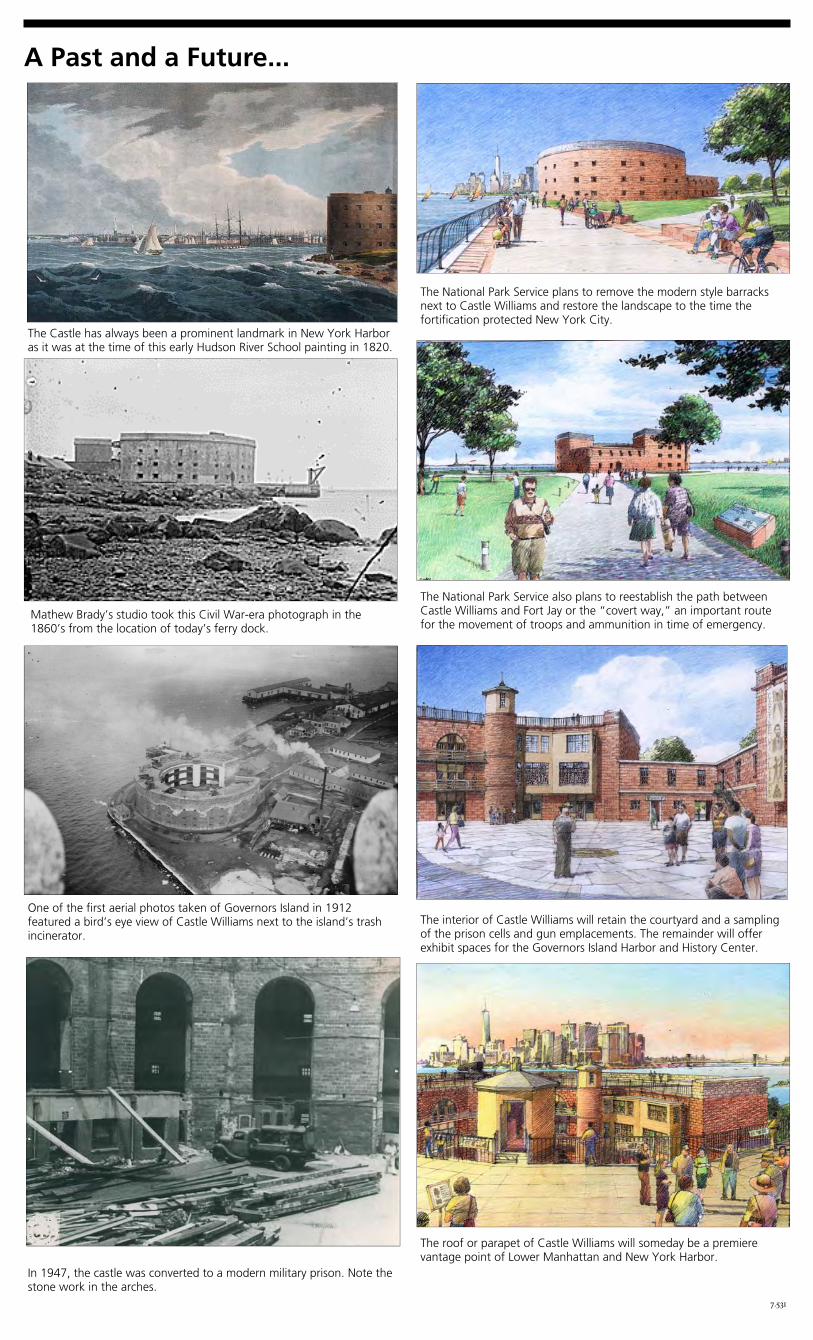
The National Park Service plans to remove the modern style barracks next to Castle Williams and restore the landscape to the time the fortification protected New York City.
The National Park Service also plans to reestablish the path between Castle Williams and Fort Jay or the “covert way,” an important route for the movement of troops and ammunition in time of emergency.
The interior of Castle Williams will retain the courtyard and a sampling of the prison cells and gun emplacements. The remainder will offer exhibit spaces for the Governors Island Harbor and History Center.
The Castle has always been a prominent landmark in New York Harbor as it was at the time of this early Hudson River School painting in 1820.
The roof or parapet of Castle Williams will someday be a premiere vantage point of Lower Manhattan and New York Harbor.
A Past and a Future...
7.531
Mathew Brady’s studio took this Civil War-era photograph in the 1860’s from the location of today’s ferry dock.
One of the first aerial photos taken of Governors Island in 1912 featured a bird’s eye view of Castle Williams next to the island’s trash incinerator.
In 1947, the castle was converted to a modern military prison. Note the stone work in the arches.