the negative relation between the monsoon …j-igu.in/igu_22-5/paper8.pdf · 1india meteorological...
TRANSCRIPT

P. Chandrasekhara Rao and Archana Shinde
534
The negative relation between the monsoon depressions and the rainfall over Rayalaseema (Andhra Pradesh), India
P. Chandrasekhara Rao* and Archana Shinde1
A 44-307, Singapore Township, Pocharam, Hyderabad-5000881India Meteorological Department, Pune
*Corresponding Author: [email protected]
AbSTRACTThe spatio-temporal variation of rainfall over India is largely dependent on the formation of cyclonic circulations, low pressure areas and depressions or cyclones in the Bay of Bengal and their movement along the monsoon trough. On the regional scale, the rainfall of Rayalaseema is considerably influenced by the low pressure systems that form in the Bay of Bengal. Rayalaseema receives rainfall in both the southwest and northeast monsoons. During both the seasons, the influence of the low pressure systems in the Bay of Bengal during the monsoon season, usually move in west north-westerly direction and cross the coasts of North Andhra, Orissa or West Bengal. They continue their movement inland and cause copious rainfall along their path. During this period, Telangana and coastal Andhra Pradesh also receive excess rain, but the rainfall received over Rayalaseema subdivision is found to be deficient with even ‘no rain’ at times. The wind pattern and the associated rainfall during the period of depressions crossing the coast and subsequent period have been analysed pertaining to a period of thirty years and the results are presented with some selected illustrations.
Keywords: Monsoon depression, Cyclonic storms, Rainfall, Rayalaseema (Andhra Pradesh), Bay of Bengal, Convergence.
INTRODUCTION
Rayalaseema is a land-locked region with an area of about 69,043 Km2 accounting for 30% of the total geographical area of Andhra Pradesh. This region extends approximately from Latitude 12°3’N to 16°15’ N and Longitude 76°55’ E to 79°55’ E. Geographically, the Rayalaseema region forms the south and south eastern part of Deccan Plateau. It is situated almost in the centre of the southern part of the Indian peninsula. It comprises four districts namely, Anantapur, Chittoor, Kudapah and Kurnool. The climate of the region is normally dry sub-humid type and is a part of the semiarid region of the interior Deccan plateau. In Rayalaseema region, Anantapur district is the second driest part of the country next to the Jaisalmer district of Rajasthan. Rayalaseema region is characterized by hot summer from March to May. This region receives more rainfall from south-west monsoon than the northeast monsoon. The average annual rainfall is hardly 672 mm. South-west monsoon spreads from early June till the end of September, while the northeast monsoon, from October to December. Anantapur district receives second lowest rainfall in the country, next to the Thar Desert of Rajasthan. Being far away from the east coast, it does not enjoy the full benefit of north-east monsoon and is also being cut off by the high Western Ghats, which prevents south-west monsoon. October and November form the retreating monsoon season. The average rainfall of the area is 545mm.
Historically known as ‘stalking ground of famines’, it is estimated that drought occurs once in three years in Rayalaseema region. Among four districts in Rayalaseema, Anantapur is the driest of all districts in the region and also in the state. Rayalaseema region comes under semi-arid area which records rainfall from 375 to 700mm. The Depressions and low-pressure areas contribute significantly to the spatiotemporal variation of monsoon. The quantum of rainfall varies depending on the track of the depressions. Rayalaseema is a region, which would be away from such track. The rainfall over the subdivisions along the track, exceed the normal in many fold. However, the regions along the west coast, which are far away from the tracks, also experience excess rainfall. On the regional scale, the rainfall of Rayalaseema is considerably influenced by such systems that form in the Bay of Bengal. Rayalaseema receives rainfall in both the southwest and northeast monsoons, as mentioned earlier. During both the seasons, the influence of the low pressure systems in Bay of Bengal is clearly felt over the region. Koteswaram and George (1958) studied the causative factors of depression formation in Bay of Bengal. Similarly, Rao and Jayaraman (1958) also made a statistical study of the depressons/storms in the Bay of Bengal. The Rainfall patterns in association with Monsoon Depressions have been studied by Pishoroty and Asnani (1957), while Rao (2004) brought out the clearly deficiency of rainfall over Rayalasema in association with Monsoon Depressions.
J. Ind. Geophys. Union ( September 2018 )v.22, no.5, pp: 534-543

The negative relation between the monsoon depressions and the rainfall over Rayalaseema (Andhra Pradesh), India
535
The well-marked low pressure areas, depressions and cyclonic storms that form in the Bay of Bengal during the monsoon season, generally move in west north-westerly direction and cross the coasts of North Andhra, Orissa or West Bengal. After the land fall, they further move inland and give widespread to fairly widespread rainfall over most parts of the regions with heavy to very heavy rain, at times. During this period, northern parts of Telangana and coastal Andhra Pradesh also receive excess rain, but the rainfall received over Rayalaseema subdivision is found to be deficient or scanty. There were even some occasions when there were no reports of ‘rain’.
DATA AND METHODOLOGY
Thirty years of rainfall data of Rayalaseema subdivision has been analysed to study the extent of depletion of rainfall in association with each depression. In this analysis, the rainfall of the weeks during which there is a movement of depression, right from its formation and its course of movement inland, has been taken into account. The tracks of the depressions are taken from the Cyclone Atlas of IMD. The percentage anomalies evaluated and published in the daily and weekly weather reports of IMD are also considered.
RESULTS AND DISCUSSIONS
Indian economy mostly depends on agriculture. With 65 to 70 per cent of cultivable land being rainfed, agriculture in turn, to a large extent is dependent on the monsoon rainfall. The pulsatory character of monsoon is a matter of concern to the farmer. Prior information regarding assured rainfall a few days in advance, is a vital input for the farming operations. Equally important would be the information regarding the depletion of rainfall during a particular period.
In general, it can be seen that the rainfall over the region is on the negative side during the passage of systems. Even during the cases of excess rainfall, the reason was found to be some other system and not the depression in question. This feature may be used as tool for medium range weather forecasting. Adequate steps may therefore be taken up at formative stage of depressions in the Bay itself for reorganising their agricultural activities, keeping in view the expected deficiency in rainfall.
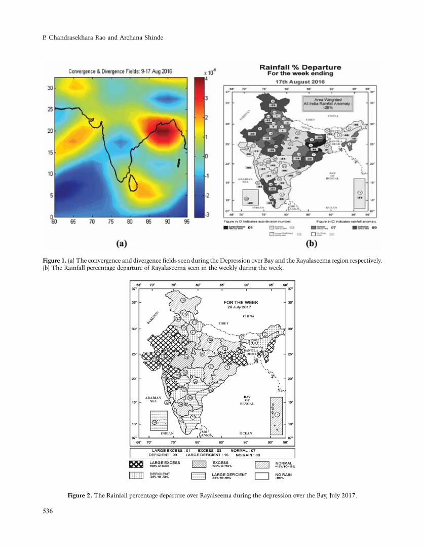
Deep Depression over bangaladesh and neighbourhood from 9-17 Aug 2016
A low pressure area formed over north of west Bay of Bengal and adjoining coastal areas of west Bengal in the early morning of 9th August 2016. It lay as a well-marked low pressure area over the same region, with an associated
cyclonic circulation extending upto 7.6 kms a.s.l. on 9th. It concentrated as a depression over coastal areas of West Bengal and its neighbourhood. It moved north-eastwards and intensified into a deep depression over south of Bangladesh and its neighbourhood. It can be seen from the vorticity picture shown in Figure 1(a), that when there is positive vorticity over the Bay region, the Rayalaseema region shows negative vorticity. The percentage departures of rainfall over various subdivisions of India are depicted Figure 1(b) taken from Weekly Weather Report 11-17, August 2016. Also from the figure it is evident, that the Rayalseema region is largely deficient in spite of there being a deep depression in the bay.
Depression over Gangetic West bengal and adjoining area of Jharkhand.
A cyclonic circulation lay over south Bangladesh and adjoining areas of Gangetic West Bengal and North Bay of Bengal, extending upto 7.6 kms a. s. l. on 22nd July 2017 and over Gangetic part of the West Bengal and neighbourhood tilting southwestwards with height on 23rd
July2017. Under its influence, a low pressure area formed over Gangetic West Bengal and adjoining areas of Jharkhand on the same evening. It lay as a well marked low pressure area over the same region on 24th – 25th July 2017. It concentrated into a Depression over northwest Jharkhand and its neighbourhood centered near Lat. 24°N/Long. 84°E, close to Daltonganj at 0830 hrs. IST of 26th July 2017. It moved northwestwards and lay over southwest Bihar and neighbourhood centered near Lat.24.5° N / Long.83.5° E, about 80 kms northwest of Daltonganj (Jharkhand) and 170 kms east of Sidhi (east Madhya Pradesh) at 1730 hrs. IST of 26th. The Depression over northwest Jharkhand and neighbourhood moved north-westwards and continued its movement toward east Uttar Pradesh and adjoining northeast Madhya Pradesh, where it weakened into a low pressure area by 27th July 2017. The rainfall during the said week is depicted in Figure 2 which shows that over Rayalaseema, it was largely deficient.
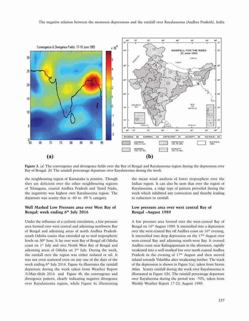
Deep Depression over NW bay and adjacent parts of north Orissa West bengal coast from 17-19 June 1993.
It was first observed as a low pressure area over north Bay and neighbourhood. It was first located in north-west Bay and adjoining parts of North Orissa- West Bengal coast. It moved in north northeasterly direction and finally dissipated over Bangladesh. Figure 3a shows the low level convergence which is negative over Rayalaseema region. The rainfall over various subdivisions of India during the week ending 23rd June 1993 is illustrated in Figure 3b. It can be seen that the percentage departure over
P. Chandrasekhara Rao and Archana Shinde
536
Figure 2. The Rainfall percentage departure over Rayalseema during the depression over the Bay, July 2017.
Figure 1. (a) The convergence and divergence fields seen during the Depression over Bay and the Rayalaseema region respectively. (b) The Rainfall percentage departure of Rayalaseema seen in the weekly during the week.
The negative relation between the monsoon depressions and the rainfall over Rayalaseema (Andhra Pradesh), India
537
the neighbouring region of Karnataka is positive. Though they are deficient over the other neighbouring regions of Telangana, coastal Andhra Pradesh and Tamil Nadu, the negativity was highest over Rayalaseema region. The departure was scanty that is -60 to -99 % category.
Well Marked Low Pressure area over West bay of bengal: week ending 6th July 2016
Under the influence of a cyclonic circulation, a low pressure area formed over west central and adjoining northwest Bay of Bengal and adjoining areas of north Andhra Pradesh-south Odisha coasts that extended up to mid tropospheric levels on 30th June. It lay over west Bay of Bengal off Odisha coast on 1st July and over North West Bay of Bengal and adjoining areas of Odisha on 2nd July. During the week, the rainfall over the region was either isolated or nil. It was not even scattered even on any one of the days of the week ending 6th July 2016. Figure 4a illustrates the rainfall departure during the week taken from Weather Report 31May-6July 2016 and Figure 4b, the convergence and divergence pattern, clearly indicating negative divergence over Rayalaseema region, while Figure 4c illustrating
the mean wind analysis of lower troposphere over the Indian region. It can also be seen that over the region of Rayalaseema, a ridge type of pattern prevailed during the week which inhibited any convection and thereby leading to reduction in rainfall.
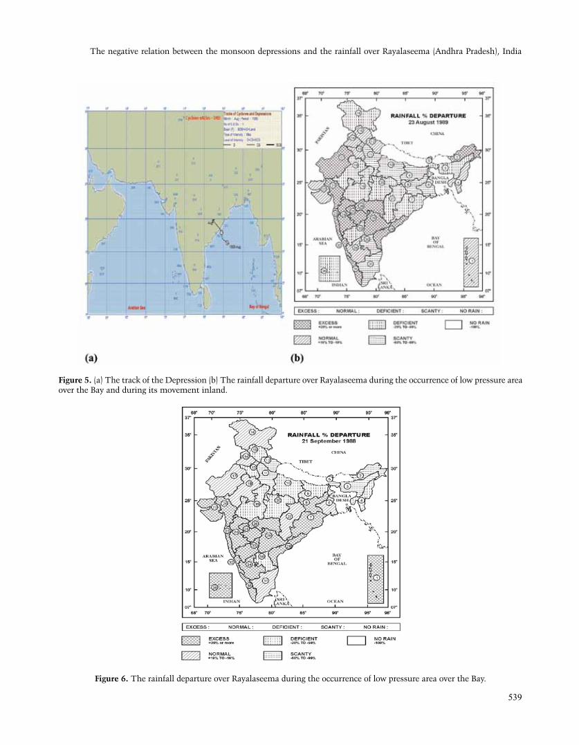
Low pressure area over west central bay of bengal –August 1989
A low pressure area formed over the west-central Bay of Bengal on 16th August 1989. It intensified into a depression over the west-central Bay off Andhra coast on 16th evening. It intensified into deep depression on the 17th August over west-central Bay and adjoining north-west Bay. It crossed Andhra coast near Kalingapatnam in the afternoon, rapidly weakened into a well-marked low over north coastal Andhra Pradesh in the evening of 17th August and then moved inland towards Vidarbha after weakening further. The track of the depression is shown in Figure 5(a), taken from Storm Atlas. Scanty rainfall during the week over Rayalaseema is illustrated in Figure 5(b). The rainfall percentage departure over Rayalseema during the period was -70%, taken from Weekly Weather Report 17-23, August 1989.
Figure 3. (a) The convergence and divergence fields over the Bay of Bengal and Rayalaseema region during the depression over Bay of Bengal. (b) The rainfall percentage departure over Rayalaseema during the week.

P. Chandrasekhara Rao and Archana Shinde
538
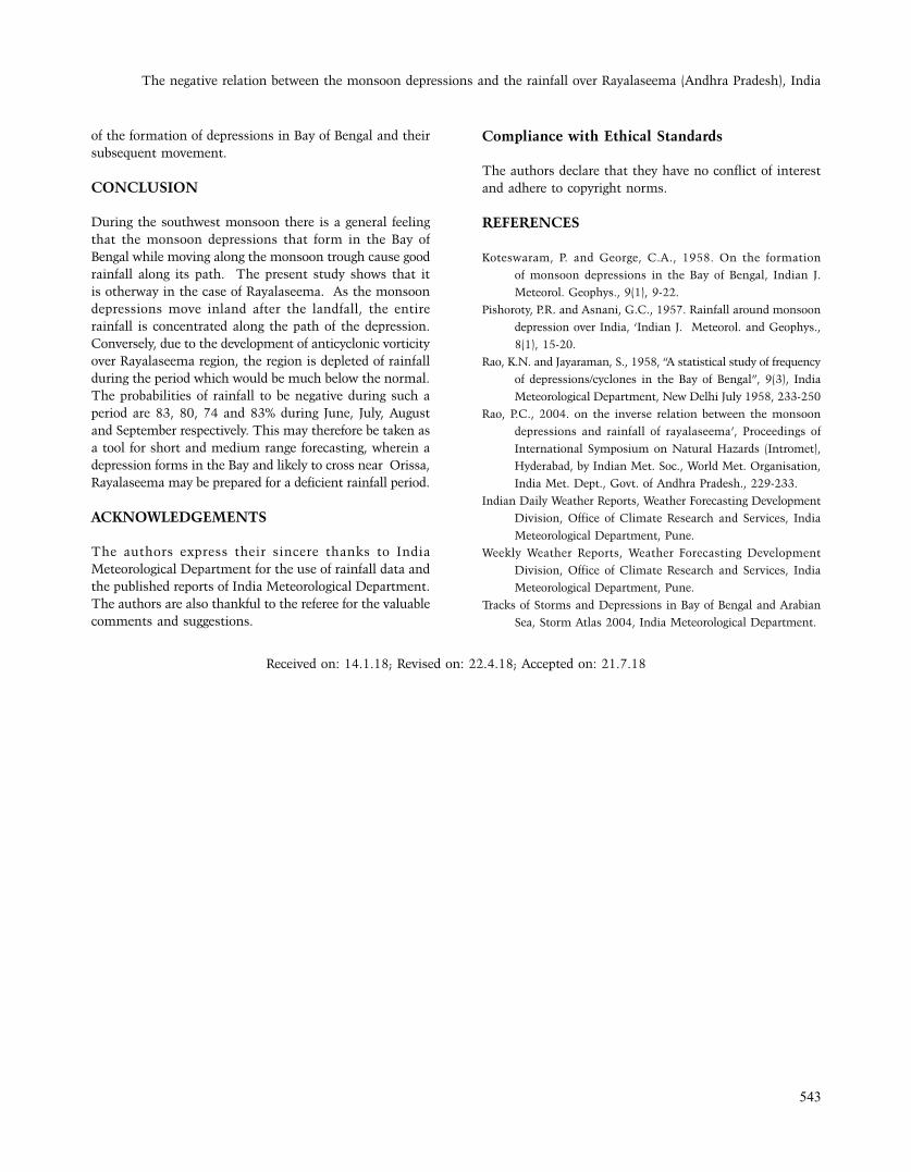
A Low pressure area over North West bay and adjoining Orissa coast on 21st September 1988
A cyclonic circulation extending upto 1.5 km a.s.l was observed off north coastal Andhra Pradesh and adjoining south Orissa coast in the evening of 20th September. Under its influence a low pressure area formed over North West Bay and adjoining Orissa coast on 21st September. Figure 6 shows the rainfall departures during the week. The rainfall all the neighbouring subdivisions is either excess or normal
whereas it is deficient over Rayalaseema. The Rainfall Departure over Rayalseema was estimated as -28% during that period. The departures are computed from the actual rainfall amounts Indian Daily Weather Reports.
Almost all the systems generally result in a similar result. It can be seen from the above graph that if we compare the number of times when there was a system in Bay and the corresponding times when the rainfall was deficient or scanty, we see that it is more than half the number of times when a system occurred and the rainfall
Figure 4. a) The rainfall departure over Rayalaseema during the occurrence low pressure over the Bay. b) Convergence pattern over India and neighbourhood, and c) lower tropospheric wind flow pattern, with mean winds at 850 hPa during the week.
The negative relation between the monsoon depressions and the rainfall over Rayalaseema (Andhra Pradesh), India
539
Figure 5. (a) The track of the Depression (b) The rainfall departure over Rayalaseema during the occurrence of low pressure area over the Bay and during its movement inland.
Figure 6. The rainfall departure over Rayalaseema during the occurrence of low pressure area over the Bay.

P. Chandrasekhara Rao and Archana Shinde
540
occurred over Rayalaseema region was deficient or scanty. For the entire data, the probabilities of rainfall to be negative during such a period are 83, 80, 74 and 83 during June, July, August and September respectively.
This is also evident from the latest monsoon situation of 2017. The cyclogenetic activity was more in Arabian Sea. The season witnessed two land systems. Two systems that formed over Bay of Bengal either dissipated or became less marked near the coasts of Bengal and Orissa. The total number of low pressure days had been only 39 as against the normal of 58. The number of low pressure days were
11, 12, 10 and 6 during the four months of the monsoon whereas the normal were 11, 14, 17 and 16 respectively. Thus, the movement of low pressure systems across the south-central India appears to result in negative rainfall over the Rayalaseema region. Figure 7 illustrates the number of systems formed in the Bay during the period of study and the corresponding number of deficient or scanty periods of rainfall.
Figures 8 to 11 show the percentage departures of rainfall over the Rayalaseema region during the months of June, July, August and September respectively. These
Figure 7. Systems in Bay and the corresponding rainfall percentage over Rayalseema during the systems.
Figure 8. Rainfall percentage over Rayalaseema during the passage of systems over Bay in the month of June.

The negative relation between the monsoon depressions and the rainfall over Rayalaseema (Andhra Pradesh), India
541
Figure 9. Rainfall percentage over Rayalaseema during the passage of systems over Bay in July.
Figure 10. Rainfall percentage over Rayalaseema during the passage of systems over Bay in the month of August.

P. Chandrasekhara Rao and Archana Shinde
542
departures in rainfall are associated with only the weeks during which the depressions forming the Bay and their subsequent movement inland. Figure 12 summarizes the
argument indicating the percentage probability of rainfall to be negative over Rayalaseema region during each month of the monsoon, in association with the periods
Figure 11. Rainfall percentage over Rayalaseema during the passage of systems over Bay in the month of August.
Figure 12. Probabilities of Negative Rainfall over Rayalaseema corresponding to the course of movement of depressions during the four months of monsoon.
The negative relation between the monsoon depressions and the rainfall over Rayalaseema (Andhra Pradesh), India
543
Compliance with Ethical Standards
The authors declare that they have no conflict of interest and adhere to copyright norms.
REFERENCES
Koteswaram, P. and George, C.A., 1958. On the formation
of monsoon depressions in the Bay of Bengal, Indian J.
Meteorol. Geophys., 9(1), 9-22.
Pishoroty, P.R. and Asnani, G.C., 1957. Rainfall around monsoon
depression over India, ‘Indian J. Meteorol. and Geophys.,
8(1), 15-20.
Rao, K.N. and Jayaraman, S., 1958, “A statistical study of frequency
of depressions/cyclones in the Bay of Bengal”, 9(3), India
Meteorological Department, New Delhi July 1958, 233-250
Rao, P.C., 2004. on the inverse relation between the monsoon
depressions and rainfall of rayalaseema’, Proceedings of
International Symposium on Natural Hazards (Intromet),
Hyderabad, by Indian Met. Soc., World Met. Organisation,
India Met. Dept., Govt. of Andhra Pradesh., 229-233.
Indian Daily Weather Reports, Weather Forecasting Development
Division, Office of Climate Research and Services, India
Meteorological Department, Pune.
Weekly Weather Reports, Weather Forecasting Development
Division, Office of Climate Research and Services, India
Meteorological Department, Pune.
Tracks of Storms and Depressions in Bay of Bengal and Arabian
Sea, Storm Atlas 2004, India Meteorological Department.
of the formation of depressions in Bay of Bengal and their subsequent movement.
CONCLUSION
During the southwest monsoon there is a general feeling that the monsoon depressions that form in the Bay of Bengal while moving along the monsoon trough cause good rainfall along its path. The present study shows that it is otherway in the case of Rayalaseema. As the monsoon depressions move inland after the landfall, the entire rainfall is concentrated along the path of the depression. Conversely, due to the development of anticyclonic vorticity over Rayalaseema region, the region is depleted of rainfall during the period which would be much below the normal. The probabilities of rainfall to be negative during such a period are 83, 80, 74 and 83% during June, July, August and September respectively. This may therefore be taken as a tool for short and medium range forecasting, wherein a depression forms in the Bay and likely to cross near Orissa, Rayalaseema may be prepared for a deficient rainfall period.
ACKNOWLEDGEMENTS
The authors express their sincere thanks to India Meteorological Department for the use of rainfall data and the published reports of India Meteorological Department. The authors are also thankful to the referee for the valuable comments and suggestions.
Received on: 14.1.18; Revised on: 22.4.18; Accepted on: 21.7.18