the ore deposits of kirwin, wyoming. by d. f. hewett.the ore deposits of kirwin, wyoming. by d. f....
TRANSCRIPT
THE ORE DEPOSITS OF KIRWIN, WYOMING.
By D. F. HEWETT.
INTRODUCTION.
In comparison with the other States the Rocky Mountain region of Wyoming contains few metalliferous mining camps. Moreover, not many of those that have been started have survived the initial period of develoment, and consequently the metalliferous production of the State, except that of iron, is small in proportion to that from its other resources. Next to the Grand Encampment district, which yielded a fair amount of copper ore from 1898 to 1908, and the South Pass dis trict,, which has a record of producing $450,000 in gold from 1868 to 1872, Kirwin was, until a few years ago, thought to possess possi bilities of steady production that made it comparable to many camps in Colorado and other Rocky Mountain States. Since 1907, how ever, with decreasing activity this hope has faded. With the ex ception of a few prospects, upon which a little work is done each summer, the district is practically abandoned.
Ore was first discovered in the region in 1890 by Will Kirwin, but the financial depression of the next few years served to retard de velopment until 1902, when vigorous exploration was undertaken by several companies, and the town of Kirwin soon had a population of about 200. The boom culminated in 1904, since when activity has steadily decreased. A snowslide in February, 1907, swept away the boarding house and storehouse of the last operators, and from that time to the present very little work has been done.
As often happens, Kirwin has been the scene of much ill-advised mining practice, with the result that the possible merit of the camp has not been fully demonstrated. Between 12,000 and 15,000 linear feet of tunnels and shafts have been opened, of which approximately 5,000 feet represents three crosscut tunnels. The purpose of these tunnels was to explore, at depths ranging from 500 to 1,500 feet, veins which had not been properly prospected near their outcrops. Although such practice may be justified in localities where the char acter and extent of the ore shoots are well understood, it is rarely successful in new districts in which the veins and shoots have been but slightly explored. At Kirwin these long tunnels have been aban doned without attaining any definite object.
121
122, CONTRIBUTIONS TO ECONOMIC GEOLOGY, 1912, PART I.
The following report is based on a week's examination of the dis trict during July, 1912. In most of the underground workings the examination was hindered by water, falls of rock, and bad air, and in the higher prospects by snow. The work was, however, furthered by the hospitality and cooperation of Mr. C. E. Tewksbury, in charge of the operations of the Wyoming Mining & Milling Co., which maintains a crew at work during the summer months.
IMile
Contour interval 260 feet
Quartz monzonite stock
Dikea - andesite d- dacite
Vein
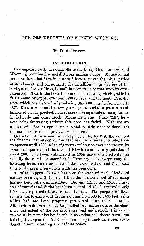
DIGURE 8. Map showing prospects near Kirwin, Wyo. 1, Elkton; 2, Galena Ridge tun nel ; 3, Little Johnnie; 4, Manila; 5, Oregon; 6, Nonety-nine shaft; 7, Ninety-eight shaft; 8, Rose Hannibal; 9, Long Horn tunnel; 10, White Dog; 11, Portland; 12, Smuggler; 13, Bryan; 14, Pickwick; 15, Tumalum; 16, Molly Logan.
SITUATION AND SURFACE FEATURES.
Kirwin is situated near the headwaters of the north fork of Wood Kiver, a tributary of Greybull Eiver, about 38 miles southwest of Meeteetse, Park County, Wyo. During the summer weekly mail service is privately maintained from Sunshine, 15 miles southwest of Meeteetse. Daily stages ply between Meeteetse and Cody, on the

ORE DEPOSITS OF KIRWIN, WYO. 123
Chicago, Burlington & Quincy Railroad, and Meeteetse and Basin, on the Thermopolis branch of the same road.
The town, now abandoned, lies at an altitude of 9,200 feet, and above it ridges rise precipitously to 12,000 feet. The topographic features of the region are well shown on the Kirwin sheet, published by the United States Geological Survey, of which figure 8 is a partial reproduction. The deep, narrow valley of Wood River is the most prominent feature of the area. The high flat-topped ridges to the northwest and southeast are spurs from the main divide of the Absa- roka Mountains, which separates the drainage basin of Wind River on the southwest from the tributaries of Owl Creek and Greybull River on the northeast. This flat-topped character of the ridges throughout the northern portion of the Kirwin quadrangle suggests the previous existence of an extensive surface of low relief, whichmay be correlated with that which has been recognized in the Bighorn Mountains.1 The numerous basins in which rise the 'tributaries of Wood River possess all the features of glacial cirques and many contain perennial snow fields of fair size.
Timber line is well defined and ranges from 10,000 to 10,300 feet; below this altitude the growth of t'imber is generally heavy and fully sufficient to meet the demands of an active mining industry.
GEOLOGY.
The rocks exposed within the area represented by figure 1 are wholly igneous and constitute a portion of the great thickness of lavas and volcanic breccias that cover several thousand square miles in northwestern Wyoming. These rocks have been studied,in detail in the Yellowstone Park 2 and in the region adjoining it on the east. 3 They have been shown to lie upon an eroded surface of folded sedimentary rocks, which range in age from Cambrian to late Creta ceous. In the lower valley of Wood River, 15 miles northeast, the basal beds of the volcanic rocks rest upon sandstones of Wasatch (Eocene) age.
On the basis of his work Hague made a sixfold classification, as follows, beginning at the base: (1) Hornblende andesite breccias, (2) augite andesite breccias and flows, (3) basalt flows, (4) hornblende andesite breccias, (5) augite andesite breccias, and (6) basalt flows. The aggregate thickness of these rocks is approximately 11,000 feet, jof which the second group constitutes about 4,000 feet. Though this classification applies to a large area in the vicinity of the Yellowstone Park, Hague points out that at least two members, the first and
i Barton, N. H., Geology of the Bighorn Mountains: Prof. Paper U. S. Geol. Survey No. 51,1906, p. 69. »Hague, Arnold, Iddings, J. P., and others, Geology of- the Yellowstone National Park, Wyoming:
Mon. U. S. Geol. Survey, vol. 32, pt. 2,1899. 3 Hague, Arnold, Absaroka folio (No. 52), Geol. Atlas U. S., U. S. Geol. Survey, 1899.
124 CONTRIBUTIONS TO ECONOMIC GEOLOGY, 1912, PAET I.
fourth, which contain hornblende in excess of augite, are of minor areal distribution.
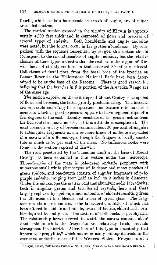
The vertical section exposed in the vicinity of Kirwin is approxi mately 4,000 feet thick'and is composed of flows and breccias of several types of andesite. Both hornblende and augite andesites were noted, but the former occur in far greater abundance. By com parison with the sequence recognized by Hague, this section should correspond to the second member of augite andesites, but the relative absence of these types indicates that the section in the region of Kir win does not strictly conform to that observed 30 miles northwest. Collections of fossil flora from the basal beds of the breccias on Lamar River in the Yellowstone National Park have been deter mined to be at the base of the Neocene.1 There is good reason for believing that the breccias in this portion of the Absaroka Range are of the same age.
The section exposed on the east slope of Mount Crosby is composed of flows and breccias, the latter greatly predominating. The breccias are separable according to composition and texture into numerous members which in good exposures appear to have regional dips of a few degrees to the east. Locally members of the group incline from the horizontal as much as 30°, but this attitude is exceptional. The most common variety of breccia contains about 50 per cent of angular to subangular fragments of one or more kinds of andesite suspended in a matrix of a different type, though the fragments locally consti tute as much as 90 per cent of the mass. No tuffaceous rocks were found in the section exposed at Kirwin.
The rock penetrated by the Tumalum shaft at the base of Mount Crosby has been examined in thin section under the microscope. Three-fourths of the mass is pale-green andesite porphyry with numerous small white phenocrysts of feldspar and many patches of green epidote, and one-fourth consists of angular fragments of pale- purple andesite, ranging from half an inch to 2 inches in diameter. Under the microscope the matrix contains abundant sodic labradorite, both in angular grains and terminated crystals, here and there largely replaced by epidote, minor amounts of chlorite resulting from the alteration of hornblende, and traces of green glass. The frag ments contain predominant sodic labradorite, a little of which has been altered to epidote and calcite, traces of biotite, chloritized horn blende, apatite, and glass. The texture of both rocks is porphyritic. The relationship here observed, in which the matrix contains abun dant epidote while the fragments, are relatively fresh, prevails throughout the district. Alteration of this type is essentially that known as " propylitic," which occurs in many mining districts in the extrusive andesitic rocks of the Western States. Fragments of a
i Hague, Arnold, Yellowstone Park folio (No. 30), Geol. Atlas U. S., U. S. Geol. Survey, 1896, p. 2.

ORE DEPOSITS OF KIRWUsT, WYO. 125
dense white latite are common on the south slope of Mount Crosby. At an altitude of 10,400 feet on the east slope of Mount Sniffel there are two zones of limestone breccia, 5 to 20 feet thick. The frag ments are angular to subangular and if they were transported by water can not have moved far from their source.
The breccias are cut by intrusions of two classes, dikes and stocks, which constitute, however, a very small portion of the surface of the district. The dikes range from dacite porphyry, in which the minerals in order of abundance are sodic labradorite, hornblende, quartz, biotite, magnetite, and apatite, to typical hornblende ande- site porphyry, in which quartz and biotite are absent. Altogether 12 dikes were observed, though there may be more in the outlying portions of the area covered by figure 8, as these were not examined in detail, and the discrimination of these masses from the breccias requires close examination of the surface.
The second class of intrusion is represented by a single example, the stock on the east slope of Brown Mountain. This stock is com posed of a light-gray granular rock which under the microscope is determined to be quartz monzonite. The proportion of the mineral constituents varies greatly from place to place within the mass. Specimens from the north end contain plagioclase in excess of ortho- clase in the ratio of 2 to 1 and augite greatly exceeding hornblende, whereas those from the center and southwest portion contain these minerals in practically the reciprocal proportions. Quartz, biotite, and magnetite are relatively constant throughout, and zircon and apatite are accessory minor constituents.
The only evidence of more than one period of intrusion in the district lies in the association of two dikes on the -east slope of Spar Mountain. At this point a narrow dike of hornblende ande- site porphyry intersects and is hence more recent than a large dike of dacite porphyry. There is no evidence that this relation pre vails throughout the district.
No dikes of basic rocks were seen in the district.
ORE DEPOSITS.
The ore deposits at Kirwin exemplify the transition between two types, the dominance of 'the characteristics of one or the other being approximately in proportion to the size of the deposit. The smaller deposits are fillings of simple fractures or fissures accompanied by slight alteration and metallization of the wall rocks; the larger deposits are narrow fracture zones or groups of fractures, several of which, though usually the outer pair, contain the greater por tion of the metallic minerals. In the larger deposits the brecciated rock between the walls is locally silicified and contains small quan tities of disseminated metallic minerals. There is, moreover, every

126 CONTRIBUTIONS TO ECONOMIC GEOLOGY, 1912, PAET I.
transition from relatively unmineralized fractures or sheeted zones to those veins which contain enough metallic minerals to encourage exploration. [Replacement of the rock beyond the walls by metallic minerals is uncommon and unimportant. Structurally the deposits are essentially similar to those that have been termed " lodes" in the Silverton district, Colorado,1 to which this district is in many ways similar.
In some places in the district the rocks over several acres are stained with limonite that is not related to definite fracture zones or veins. - The largest of these areas lies at an altitude of 10,000 feet on the west slope of Dundee Mountain and has been explored by two tunnels. The breccias are silicified and, though there is much disseminated pyrite, no well-defined veins have been found.
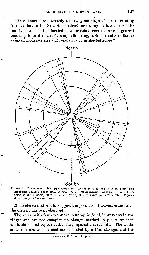
The courses of the sheeted zones are, with but few exceptions, nearly rectilinear, and figure 9 shows the directions of those which have been recognized during this examination. In this summary only zones having an areal extent in excess of several acres have been included. Of nine sheeted zones, eleven dikes, and eighteen veins which were found, eight zones, six dikes, and eleven veins coincide within 5° of three planes, (1) N. 15° W., dipping steeply east; (2) N. 60° W., dipping 75° NE.; (3) S. TO0 W., dipping 80° N. In considering the significance of an apparent coincidence of these directions it must be recognized that the number of observations is small, and that there is a probability that all the veins and dikes are not known; further, that joint systems are in places relatively local and elsewhere relatively extensive, hence there is a tendency to give undue weight to the less widespread systems.
As bearing on the relative age of the stock, joint systems, dikes, and veins it should be noted that one vein has been explored in the monzonite stock and that the mass is extensively fractured parallel to two of the joint systems. Furthermore, the large dike on Spar Mountain is intersected by two veins (Smuggler) and a smaller dike, whereas the other dikes, though superficially much fractured, fill joints of the systems mentioned and are not intersected by them. At least' one vein, the Tumalum, is intersected by a dike, and the exploration of each of four others has shown the presence of a par allel dike in one of the walls.
The simplest inference consistent with these observations is that there were at least two general periods of intrusion, between which extensive joint systems were established and veins formed. It should be remembered, however, that the simplest interpretations in the geology of ore deposits are seldom complete and may be highly misleading. The conclusions are stated merely to indicate probable relationships.
i Ransome, F. L., Economic geology of the Silverton quadrangle; Colorado: Bull. U. S. Geol. Survey No. 182,1901, p. 44.
ORE DEPOSITS OF KIRWIN, WYO. 127
These fissures are obviously relatively simple, and it is interesting to note that in the Silverton district, according to Kansome,1 "the massive lavas and indurated flow breccias seem to have a general tendency toward relatively simple fissuring, such as results in fissure veins of moderate size and regularity or in sheeted zones."
North
SouthFIGUBB 9. Diagram showing approximate coincidence of directions of veins, dikes, and
important sheeted zones near Kirwin, Wyo. Observations indicated by full lines. Veins in inner circle, dikes in middle circle, sheeted zones in outer circle. Figures show number of observations.
No evidence that would suggest the presence of extensive faults in the district has been observed.
The veins, with few exceptions, outcrop in .local, depressions in the ridges and are not conspicuous, though marked in places by iron oxide stains and copper carbonates, especially malachite. The walls, as a rule, are well defined and bounded by a thin selvage, and the
i Ransome, F. L., op. cit, p. 54.
128 CONTBIBUTIOBTS TO ECONOMIC GEOLOGY, 1912, PART I.
distance between them ranges from a few inches to a maximum of 4 feet. Between the walls there is usually one and in some places two bands of sulphide minerals, ranging in width from 1 to 14 inches, which tend to follow one or both walls, as the case may be. The sulphide minerals either show crustification, indicating growth in open spaces, or are disseminated in minute grains in such a manner as to indicate replacement of the breccia. Locally the relation of the sulphides indicates that one has been formed later than another, either by filling many minute fractures in the grains or the spaces between grains or by replacement of the fractured minerals.
The following minerals were identified in the unaltered portions of the veins of the district, the order being approximately that of the abundance in which they are found; Pyrite, chalcopyrite, sphalerite, galena, tetrahedrite-, molybdenite, stephanite, and specular hematite. The minerals found in the superficial or oxidized zone are limonite, malachite, azurite, cuprite, and native gold. Quartz, locally of the amethystine variety, is the principal gangue mineral, though calcite, dolomite, siderite, and barite are present in most of the veins. Adu- laria was not noted, but as it is a prominent constituent of some of the veins of the Sunlight district, 40 miles northwest, which possess many features in common wth those at Kirwin, it may be sparingly present. The proportion in which the sulphide minerals occur in the veins varies greatly throughout the district. It ranges from as much as 95 per cent in the Pickwick vein, where pyrite is the only sulphide, to less than 5 per cent in the Oregon vein, where sulphide minerals occur in approximately the ratios sphalerite: galena: pyrite= 10:3:2, with traces of chalcopyrite.
Observations of hand specimens of material from several of the Veins, collected both underground and from dumps, suggested that some of the minerals were not deposited contemporaneously with others that constituted the greater portion of the vein. With a view to interpreting the order in which the minerals were deposited in these veins, several polished sections of material from the veins have been examined in detail under the microscope. A typical specimen from the Bryan No. 3 vein is reproduced in figure 10, a, and shows an area of relatively pure chalcopyrite adjoining another composed of grains of pyrite with a minor amount of quartz in which there are many minute veinlets of chalcopyrite. The area of chalcopyrite contains many minute round grains of pyrite, in places grouped in clusters, whereas in the other area chalcopyrite either tends to envelop pyrite fragments completely or occurs as a network of minute veinlets penetrating large grains of pyrite. These relations suggest that the clusters of round grains represent the residuals of larger pyrite grains which have been almost completely replaced by chal copyrite and that this replacement has been incomplete in the

ORE DEPOSITS OF KIBWIN, WYO. 129
adjoining area, They also suggest the inference that, here at least, chalcopyrite was formed at a period distinctly later than the pyrite. Underground conditions, unfortunately, did not permit de tailed observations bearing on the economic significance of these features. The chemical formula of chalcopyrite is CuFeS 2 , whereas pyrite is FeS2 . When chalcopyrite replaces pyrite there may be mere addition of one atom of copper to the pyrite molecule, in which case there will be an increase in volume of 81.7 per cent, or there may be addition of copper with the corresponding loss of iron and sulphur. If a fractured grain of pyrite, such as is shown in figure 10, a, were replaced by chalcopyrite by the addition of copper to the free sur faces without corresponding solution of a portion of the pyrite, there should be evidence of an increase in volume, such as the swelling of the outer fragments away from the mass. The absence of any evi-
I / ' .0 .__.. 5 L
(MillimetersFIGURE 10. a, Specimen from Bryan No. 3 vein, showing chalcopyrite (black), pyrite
(white), and quartz (stippled), ft, Specimen from Tumalum vein, showing pyrite (white), tetrahedrite (black), and quartz (stippled).
dence of increase in volume shows that increase in volume caused by the replacement of pyrite by chalcopyrite has been accompanied by solution of a corresponding volume of pyrite. The specimen is a good illustration of replacement not involving change in volume. 1
The Tumalum shaft is filled with water, so that it was not possible to examine the vein. In the material on the dump two distinct types of mineral associations were found. One type, which is illustrated by most of the material, shows an aggregate of fragments of pyrite and quartz, the interstices of which are filled with tetrahedrite. (See fig. 10, &). Many of the fractured grains of pyrite have clearly been broken from grains of corresponding shape near by. None of the pyrite grains show the network of fractures which would be a feature of replacement, and there is no evidence that this process has taken place. A few of the pyrite fragments contain minute grains of
i See Lindgren, Waldemar, The nature of replacement: Econ. Geology, vol. 7,1912, p. 534. 22652° Bull. 540 14 9

130 CONTRIBUTIONS TO ECONOMIC GEOLOGY, 1912, PAET I.
galena, and there is a little chalcopyrite associated w.ith the tetra- hedrite.
The second type of association shown on the Tumalum dump is that of galena with sphalerite and pyrite. Galena tends to com pletely envelop both aggregates of pyrite grains and small masses of sphalerite and to fill many of the interstices between the pyrite grains as well as fractures in the sphalerite. The associations indicate the deposition of galena in minutely fractured sphalerite and pyrite. Material from the oxidized zone of the Little Johnnie vein contains a small proportion of sulphide minerals, pyrite, and chalcopyrite in quartz which in places shows crusted growth. Stephanite occurs as crystals lining and in places almost filling small quartz-lined cavities. The stephanite is clearly the last mineral that was deposited in the vein.
The foregoing observations are obviously isolated and the rela tions indicated can not be urged to the exclusion of all others, but taken with other observations in the field they suggest certain infer ences. In most of the veins of the district the primary ore probably consisted of pyrite with minor amounts of sphalerite and chalcopy rite. In the two veins which have been most extensively developed, the Bryan and Tumalum, the primary minerals have been crushed and a secondary group of sulphide minerals deposited chalcopyrite in the Bryan No. 3 vein and tetrahedrite and galena in the Tumalum vein. Whether these secondary minerals have been formed by the process of dowriWard enrichment or by ascending deep-seated waters can not be stated. The proof of formation by downward enrich ment involves data which are not available,1 but it is at least possi ble that the second period of mineral deposition in the Tumalum vein is related to a second period of intrusion of dikes, as previously indicated. This does not appear to be the cause of the stephanite of the Little Johnnie vein, which is probably due to downward enrich ment.
In only-four places in the camp has sufficient work been done to demonstrate with relative assurance the horizontal extent of an ore shoot, these being Bryan, Pickwick, Tumalum, and Oregon. In only one of these, the Bryan, has the vein been explored sufficiently on more than one level to determine even approximately the limits of a shoot, so that it is evident that only the most general statement can be made about the attitude of the shoots in the vein. The hori zontal extent of the shoots ranges from 50 to 250 feet, and the Bryan shoot coincides with the dip of the vein.
The value of the ores in the district lies mainly in the gold con tent, and only rarely in silver. No assays have been made in connec tion with this examination. Information placed at the writer's dis-
1 Ransome, F. L., Criteria of downward enrichment: Econ. Geology, vol. 5,1910, p. 205.

ORE DEPOSITS OF KIBWIN, WYO. . 131
posal by Mr. C. E. Tewksbury indicates that selected material from some veins has yielded 200 ounces of silver a ton and from others 15 ounces of gold a ton, though such results must be regarded as ex ceptional. It is doubtful if the average tenor of any vein is even approximately known, for there has been very little stoping. The only shipment known to have been made from the district was a carload taken from the upper or No. 2 Bryan tunnel and is reported to have yielded a net return of $65 a ton after all transportation and smelting charges had been deducted.
PROSPECTS.
The most ambitious project of the district is the Galena Bidge tunnel, 2,327 feet long, for .the driving of which compressed air drillsand electric haulage were installed. Bad air prevented access in 1912. The tunnel is reported to have cut the Little Johnnie vein explored on the surface and some other small veins. No drifts were run on the veins from the tunnel level.
The Bryan vein is opened by tunnels 1, 2, and 3, which are 80, 480, and 880 feet long, respectively. From the lowest tunnel there are also about 1,200 feet of drifts. Four veins were cut, two of which have been explored. Vein No. 3 attains a maximum width of 4 feet and at its widest part contains two bands of sulphide minerals, which were estimated to constitute 15 per cent of its bulk. Vein No. 4 is a simple filled fracture and attains a maximum width of 10 inches, between well-defined walls. The sulphide minerals were esti mated to exist in approximately the proportions pyrite: chalcopy- rite: sphalerite=20:5:1, with traces of galena and molybdenite.
The Pickwick vein has been explored by a crosscut tunnel 610 feet long from which a drift follows the vein, for 300 feet. The vein is a simple fracture filled with pyrite, and has a maximum width of 14 inches. Kuby silver (proustite) is reported from surface work-, ings, and silver is said to have constituted the principal value of the vein material.
The workings of the Tumalum vein are filled with water, but are stated by Mr. Tewksbury to comprise a shaft 250 feet deep, from which drifts extend 230 feet east along the vein. The vein in places is 4 feet wide and contains pyrite with small amounts of galena, sphalerite, chalcopyrite, and tetrahedrite. Assays as high as $90 a ton in gold are reported.
The Molly Logan tunnel is not accessible on account of bad air, but is reported to be 1,400 feet long. It was driven in the hope of cutting a vein which was explored on the surface 600 feet higher, but was abandoned without attaining that object.
The Oregon vein is opened by a tunnel 340 feet long. It ranges from 4 to 20 inches in width between well-defined walls and contains
132 CONTRIBUTIONS TO ECONOMIC GEOLOGY, 1912, PART I.
sphalerite, galena, and pyrite in the proportion 10:3:2, with traces of chalcopyrite. The gangue is siderite and quartz. Selected ore is reported to have contained as much as 200 ounces of silver a ton.
The Long Horn tunnel has recently been driven by the Wyoming Mining & Milling Co. In July, 1912, it was 1,170 feet long, but no veins had been cut.
There are a number of other short tunnels and shafts in the dis trict, most of which were wholly or largely inaccessible on account of caves, water, bad air, and snow. None appear to have explored veins notably different from those described.
COMPARISON WITH OTHER DISTRICTS.
Spurr,1 in the report,upon the Tonopah. district, has pointed out that a number of mining districts throughout western North Amer ica have several features in common. These features are kind of country rock, age and structure of veins, vein minerals, and charac ter of rock alteration. The Kirwin district belongs to this group. The similarity, however, as is unfortunately often the case in metal liferous districts, is qualitative rather than quantitative and is by no means to be construed as implying the existence of ore bodies of similar size and richness in each of the districts. Compared to many of these districts, of which only a few are mentioned by Spurr, Kir win is characterized by fewer and smaller intrusive rock masses, by less complete and less extensive rock alteration (in some of the districts, such as Silverton, alteration is locally marked), and by narrower and less persistent veins in which the ore shoots appear to be relatively small. The absence of extensive metallization at Kirwin may be due in part to the absence of large intrusive masses of siliceous igneous rocks.
FUTURE OF THE DISTRICT.
The region in which Kirwin lies is difficult of access, and owing to its scanty natural resources there appears to be little reason for anticipating better transportation facilities in the near future. From what is to be seen in the .district it seems unlikely that there will be developed masses of low-grade ore large enough to warrant the installation of elaborate milling plants. The only ores that have thus far been produced are of medium or high grade, but in quantities too small to warrant costly equipment or operation on a large scale.
Mining, however, is full of uncertainties and it would be unsafe on the basis of a brief examination to predict that none of the Kir win deposits will ever prove to be important.
1 Spurr, J. E., Geology of the Tonopah mining district, Nevada: Prof. Paper IT. S. Geol. Survey No. 42,1905, p. 267.

SURVEY PUBLICATIONS ON GOLD AND SILVER.
The following list includes the more important publications by the United States Geological Survey, exclusive of those on Alaska, on precious metals and mining districts. Certain mining camps, while- principally copper or lead producers, yield also smaller amounts of gold and silver. Publications on such districts are listed in the bibliographies for copper and for lead and zinc. When two metals are of importance in a particular district, references may be dupli cated. A list of publications on Alaska is given in Bulletin 542, the annual report on the progress of the Survey's investigations in Alaska for 1912.
These publications, except those to which a price is affixed, may be obtained free by applying to the Director, United States Geological Survey, Washington, D. C. The priced0 publications may be pur chased from the Superintendent of Documents, Government Printing Office, Washington, D. C.; the monographs from either the Director or the Superintendent of Documents. The publications marked "Exhausted" are not available for distribution, but may be seen at the larger libraries of the country.ARNOLD, RALFH, Gold placers of the coast of Washington: Bull. 260,1905, pp. 154-157.
40c. BAIN, H. F., Reported gold deposits of the Wichita Mountains [Okla.]: Bull. 225,
1904, pp. 120-122. 35c. BALL, S. H., A geologic reconnaissance in southwestern Nevada and eastern California:
Bull. 308, 1907, 218 pp. BANCROFT, HOWLAND, Reconnaissance of the ore deposits in northern Yuma County,
Ariz.: Bull. 451, 1911, 130 pp. The ore deposits of northeastern Washington: Bull. 550 (in preparation). BARRELL, JOSEPH, Geology of the Marysville mining district, Montana: Prof. Paper
57, 1907, 178 pp. 50c. BECKER, G. F., Geology of the Comstock lode and the Washoe district, with atlas:
Mon. 3, 1882, 422 pp. $11. Gold fields of the southern Appalachians: Sixteenth Ann. Rept., pt. 3,1895,
pp. 251-331. Witwatersrand banket, with notes on other gold-bearing pudding stones:
Eighteenth Ann. Rept., pt. 5, 1897, pp. 153-184. $1.Brief memorandum on the geology of the Philippine Islands: Twentieth
Ann. Rept., pt. 2, 1900, pp. 3-7. BOTJTWELL, J. M., Economic geology of the Bingham mining district, Utah: Prof.
Paper 38, 1905, pp. 73-385. $1.10. BOUTWELL, J. M., Geology and ore deposits of the Park City district, Utah, with
contributions by L. H. Woolsey: Prof. Paper 77,1912, 231 pp. 85c.133
134 CONTRIBUTIONS TO ECONOMIC GEOLOGY, 1912, PART I.
BUTLER, B. S., Geology and ore deposits of the San Francisco and adjacent districts,Utah: Prof. Paper 80,1913, 212 pp.
BUTLER, B. S., and DUNLOP, J. P., Precious and semiprecious metals in the CentralStates in 1912 (mine production): Mineral [Resources U. S. for 1912. 1913.
CALKINS, F. C., and JONES, E. L., Geology of the St. Joe-Clearwater region, Idaho:Bull. 530, pp. 75-86.
CALKINS, F. C., and MACDONALD, D. F., A geologic reconnaissance in northern Idahoand northwestern Montana: Bull. 384,1909,112 pp.
COLLIER, A. J., Gold-bearing river sands of northeastern Washington: Bull. 315,1907,pp. 56-70. 50c.
CROSS, WHITMAN, General geology of the Cripple Creek district, Colorado: SixteenthAnn. Kept., pt. 2; 1895, pp. 13-109. $1.25.
Geology .of Silver Cliff and the Rosita Hills, Colorado: Seventeenth Ann.Kept., pt. 2, 1896, pp. 269-403. $2.35.
CROSS, WHITMAN, and SPENCER, A. C., Geology of the Rico Mountains, Colorado:Twenty-first Ann. Rept., pt. 2, 1900, pp. 15-165. $1.75.
CURTIS, J. S., Silver-lead deposits of Eureka, Nev.: Mon. 7,1884, 200 pp. $1.20. DILLER, J. S:, The Bohemia mining region of western Oregon, with notes on the Blue
River mining region: Twentieth Ann. Kept., pt. 3,1900, pp. 7-36. $1.50. Mineral resources of the Indian Valley region, California: Bull. 260, 1905,
pp. 45-49. Exhausted. Geology of the Taylorsville region, California: Bull. 353, 1908, 128 pp. The auriferous gravely of the Trinity River basin, California: Bull. 470,
1911, pp. 11-29.Mineral resources of southwestern Oregon: Bull. 546 (in press).
DILLER, J. S., and KAY, G. F., Mines of the Riddles quadrangle, Oregon: Bull. 340, 1908, pp. 134-151. 30c.
Mineral resources of the Grants Pass quadrangle and bordering districts,Oregon: Bull. 380,1909, pp. 48-79. 40c.
EMMONS, S. F., Geology and mining industry of Leadville, Colo., with atlas: Mon.12, 1886, 770 pp. $2.40.
Progress of the precious-metal industry in the United States since 1880: Min eral Resources U. S. for 1891,1893, pp. 46-94. 50c.
Economic geology of the Mercur mining district, Utah: Sixteenth Ann. Kept.,pt. 2, 1895, pp. 349-369. $1.25.
The mines of Custer County, Colo.: Seventeenth Ann. Rept., pt. 2, 1896,pp. 411-472. $2.35.
EMMONS, S. F., and IRVING, J. D., The Downtown district of Leadville, Colo.: Bull.320,1907, 75 pp.
EMMONS, W. H., The Neglected mine and near-by properties: Colorado: Bull. 260.1905, pp. 121-127. Exhausted.
Ore deposits of Bear Creek, near Silverton, Colo.: Bull. 285,1906, pp. 25-27. Exhausted.
The Granite Bimetallic and Cable mines, Philipsburg quadrangle, Montana: Bull. 315,1907, pp. 31-55. 50c.
Gold deposits of the Little Rocky Mountains, Montana: Bull. 340, 1908, pp. 96-116. 30c.
' Reconnaissance of some mining camps in Elko, Lander, and Eureka counties,Nev.: Bull. 408,1910,130 pp.
The enrichment of sulphide ores: Bull. 529,1913, 260 pp. 20c.EMMONS, W. H., and CALKINS, F. C., Geology and ore deposits of the Philipsburg
quadrangle, Montana: Prof. Paper 78,1913, 272 pp. EMMONS, W. H., and GARREY, G. H., Notes on the Manhattan district, Nevada:
Bull. 303, 1907, pp. 84-93. 15c.
SURVEY PUBLICATIONS ON GOLD AND SILVER. 135
EMMONS, W. H., and LARSEN, E. S., A preliminary report on the geology and oredeposits of Creede, Colo.: Bull. 530, 1913, pp. 42-65.
GALE, H. S., The Hahns Peak gold field: Bull. 285, 1906, pp. 28-34. Exhausted. Gold placer deposits near Lay, Routt County, Colo.: Bull. 340, 1908, pp.
84-95. 30c. GERRY, C. N., Precious and semiprecious metals in Idaho and Washington in 1912
(mine production): Mineral Resources U. S. for 1912, 1913. GRATON, L. C., Reconnaissance of some gold and tin deposits of the southern
Appalachians, with notes on the Dahlonega mines, by Waldemar Lindgren: Bull.293, 1906, 134 pp. 15c.
HAGUE, ARNOLD, Geology of the Eureka district, Nevada: Mon. 20, 1892, 419 pp.$5.25.
HAHN, 0. H., The smelting of argentiferous lead ores in the Far West: MineralResources U. S. for 1882, 1883, pp. 324-345. 50c.
HEIKES, V. C., Precious and semiprecious metals in Arizona, Nevada, Utah, andMontana in 1912 (mine production): Mineral Resources U. S. for 1912, 1913.
HENDERSON, C. W., Precious and semiprecious metals in South Dakota and Wyomingin 1912 (mine production): Mineral Resources U. S. for 1912, 1913.
HESS, F. L., Gold mining in the Randsburg quadrangle, California: Bull. 430, 1910,pp. 23^7.
HILL, J. M., Notes on the economic geology of southeastern Gunnison County, Colo.:Bull. 380, 1909, pp. 21-40. 40c.
Notes on the placer deposits of Greaterville, Ariz.: Bull. 430,1910, pp. 11-22. Notes on the economic geology of the Ramsey, Talapoosa, and White Horse-
mining districts, in Lyon and Washoe counties, Nev.: Bull. 470, 1911, pp. 99-108. Mining districts of the western United States: Bull. 507,1912, 309 pp.
Notes on the northern La Sal Mountains, Grand County, Utah: Bull. 530,1913, pp. 99-118.
IRVING, J. D., Ore deposits of the Ouray district, Colorado: Bull. 260,1905, pp. 50-77.Exhausted.
IRVING, J. D., and BANCROFT, HOWLAND, Geology and ore deposits near Lake City,Colo.: Bull. 478, 1911, 128 pp.
IRVING, J. D., and EMMONS, S. F., Economic resources of northern Black Hills:Prof. Paper 26, 1904, pp. 53-212. 55c.
KNOPF, ADOLPH, Ore deposits of the Helena mining region, Montana: Bull. 527,1913,143 pp.
LARSEN, E. S., The economic geology of Carson camp, Hinsdale County, Colo.: Bull.470, 1911, pp. 30-38.
LINDGREN, WALDEMAR, The gold-silver mines of Ophir, Cal.: Fourteenth Ann. Rept.,pt. 2, 1894, pp. 243-284. $2.10.
The gold-quartz veins of the Nevada City and Grass Valley districts, Cali fornia: Seventeenth Ann. Rept., pt. 2, 1896, pp. 1-262. $2. 35.
The mining districts of the Idaho Basin and the Boise Ridge, Idaho: Eighteenth Ann. Rept., pt. 3, 1898, pp. 625-736. $2.15.
The gold and silver veins of Silver City, De Lamar, and other mining dis tricts in Idaho: Twentieth Ann. Rept., pt. 3, 1900, pp. 75-256. $1.50.
The gold belt of the Blue Mountains of Oregon: Twenty-second Ann. Rept., pt. 2, 1901, pp. 551-776. $2.25.
A geological reconnaissance across the Bitterroot Range and Clearwater Mountains in Montana and Idaho: Prof. Paper 27, 1904, pp. 82-116.
Tests for gold and silver in shales from western Kansas: Bull. 202, 1902, 21 pp. 5c.
The production of gold in the United States in 1904: Bull. 260, 1905, pp.32-38. Exhausted.

136 CONTRIBUTIONS TO ECONOMIC GEOLOGY, 1912, PART I.o
LINDGKEN, WALDEMAR, The production of silver in the United States in 1904: Bull. 260, 1905, pp. 39^4. Exhausted.
The Annie Laurie mine, Piute County, Utah: Bull. 285, 1906, pp. 87-90. Exhausted.
'-. Notes on the Dahlonega mines: Bull. 293,1906, pp. 119-128. 15c. Geology and gold deposits of the Cripple Creek district, Colorado: Prof.
Paper 54,1906, 516 pp. $1.75. A geological analysis of the silver production of the United States in 1906:
Bull. 340, 1908, pp. 23-35. 30c. Resources of the United States in gold, silver, copper, lead, and zinc: Bull.
394, 1909, pp. 114-156.The Tertiary gravels of the Sierra Nevada of California: Prof. Paper 73,
1911, 226 pp. LINDGBEN, WALDEMAR, GRATON, L. C., and GORDON, C. H., The ore deposits of
New Mexico: Prof. Paper 68, 1910, 361 pp. LINDGREN, WALDEMAR, and RANSOME, F. L., The geological resurvey of the Cripple
Creek district: Bull. 254, 1905, 36 pp. Geology and gold deposits of the Cripple Creek district, Colorado: Prof.
Paper 54, 1906, 516 pp. $1.75.LORD, ELIOT, Comstock mining and miners: Mon. 4, 1883, 451 pp. $1.50.MAcDoNALD, D. F., Economic features of northern Idaho and northeastern Mon
tana: Bull. 285, 1906, pp. 41-52. Exhausted. Notes on the Bohemia mining district, Oregon: Bull. 380, 1909, pp. 80-84.
40c. The Weaverville-Trinity Center gold gravels, Trinity County, Cal.: Bull.
430, 1910, pp. 48-58.Notes on the gold lodes of the Carrville district, Trinity County, Cal.: Bull.
530, 1913, pp. 9-41.McCASKEY, H. D., Notes on some gold deposits of Alabama: Bull. 340, 1908, pp.
36-52. 30c. Gold and silver in 1912: Mineral Resources U. S. for 1912, 1913. ! Precious and semiprecious-metals in the Eastern States in 1912 (mine pro
duction): Mineral Resources U. S. for 1912, 1913. NITZE, H. B. C., History of gold mining and metallurgy in the Southern States:
Twentieth Ann. Rept., pt. 6, 1899, pp. 111-123. $1. PAIGE, SIDNEY, The ore deposits near Pinos Altos, N. Mex.: Bull. 470, 1911, pp.
109-124. t ," PARDEE, J. T., Faulting and vein structure in the Cracker Creek gold district, Baker
County, Oreg.: Bull. 380, 1909, pp. 85-93. 40c. Placer gravels of the Sumpter and Granite districts, eastern Oregon: Bull.
430, 1910, pp. 59-65.Geology and mineralization of the upper St. Joe River Basin, Idaho: Bull.
470, 1911, pp. 39-61.PENROSE, R. A. F., jr., Mining geology of the Cripple Creek district, Colorado: Six
teenth Ann. Rept., pt. 2,1895, pp. 111-209. $1.25.PURINGTON, C. W., Preliminary report on the mining industries of the Telluride
quadrangle, Colorado: Eighteenth Ann. Rept., pt. 3, 1898, pp. 745-850. $2.15.RANSOME, F. L., Report on the economic geology of the Silverton quadrangle, Colo
rado: Bull. 182, 1901, 265 pp. 50c. The ore deposits of the Rico Mountains, Colorado: Twenty-second Ann.
Rept., pt. 2, 1901, pp. 229-398. $2.25. ' Preliminary account of Goldfield, Bullfrog, and other mining districts in
southern Nevada: Bull. 303, 1907, pp. 7-83. 15c. Geology and ore deposits of Goldfield, Nev.': Prof .Paper 66,1909,258 pp. $1.50. Some mining districts of Humboldt County, Nev.: Bull. 414, 1909, 75 pp.

SURVEY PUBLICATIONS ON GOLt> AND SILVER. 1S7
RANSOME, F. L., The Hornsilver district, Nevada: Bull. 380,1909, pp. 41-43. 40c. Bound Mountain, Nevada: Bull. 380,1909, pp. 44-47. 40c. Geology and ore deposits of the Breckenridge district, Colorado: Prof. Paper
75,1911,187 pp. RANSOME, F. L., and CALKINS, F. C., Geology and ore deposits of the Coeur d'Alene
district, Idaho: Prof. Paper 62,1908, 203 pp. 85c. RANSOME, F. L., EMMONS, W. H., and GARRET, G. H., Geology and ore deposits
of the Bullfrog district, Nevada: Bull. 407,1910, 128 pp. SCHRADER, F. C., Mineral deposits of the Cerbat Range, Black Mountains, and Grand
Wash Cliffs, Mohave County, Ariz.: Bull. 340, 1908, pp. 53-84.- 30c. SCHRADER, F. C., The mineral deposits of the Cerbat Range Black Mountains and
Grand Wash Cliffs, Mohave County, Ariz.: Bull. 397,1909, 226 pp. 35c. Gold-bearing ground moraine in northwestern Montana: Bull. 470,1911, pp.
62-74. A reconnaissance of the Jarbidge, Contact, and Elk Mountain mining dis
tricts, Elko County, Nev.: Bull. 497,1912, 162 pp.Notes on the Antelope district, Nevada: Bull. 530,1913, pp. 87-9
SCHULTZ, A. R., Geology and geography of a portion of Lincoln County, Wyoming:Bull. 543 (in press).
SMITH, G. 0., Gold mining in central Washington: Bull. 213, 1903, pp. 76-80. 25c. Quartz veins in Maine and Vermont: Bull. 225,1904, pp. 81-88. 35c. SPURR, J. E., Economic geology of the Mercur mining district, Utah: Sixteenth
Ann. Rept., pt. 2,1895, pp. 343-455. $1.25. Geology of the Aspen mining district, Colorado; with atlas: Mon. 31,1898,
260 pp. $3.60. The ore deposits of Monte Cristo, Washington: Twenty-second 'Ann. Rept.,
pt. 2,1901, pp. 777-866. $2.25. Ore deposits of Tonopah and neighboring districts, Nevada: Bull. 213,
1903, pp. 81-87. 25c. Geology of the Tonopah mining district, Nevada: Prof. Paper 42, 1905,
295 pp.Ore deposits of the Silver Peak quadrangle, Nevada: Prof. Paper 55, 1906,
174 pp.SPURR, J. E., and GARRET, G. H., Preliminary report on the ore deposits of the George
town mining district, Colorado: Bull. 260,1905, pp. 99-120. Exhausted. The Idaho Springs mining district, Colorado: Bull. 285, 1906, pp. 35-40.
Exhausted.Economic geology of the Georgetown quadrangle (together with the Empire
district), Colorado, with general geology by S. H. Ball: Prof. Paper 63, 1908, ' 422pp. " -*
STONE, R. W., Geologic relation of ore deposits in the Elkhorn Mountains, Montana: Bull. 470,1911, pp. 75-98.
TOWER, G. W., and SMITH, G. O., Geology and mining industry of the Tintic district, Utah: Nineteenth Ann. Rept., pt. 3,1899, pp. 601-767. $2.25.
UMPLEBT, J. B., A preliminary account of the ore deposits on the Loon Creek dis trict, Idaho: Bull. 530, 1913, pp. 66--74.
Some ore deposits in northwestern Custer County, Idaho: Bull. 539, 1913, 104 pp.
Geology and ore deposits of Lemhi County, Idaho: Bull. 528,1913,182 pp.WEED, W. H., Geology and mining resources of the Judith Mountains of Montana:
Eighteenth Ann. Rept., pt. 3, 1898, pp. 446-616. $2.15. Geology of the Little Belt Mountains, Montana, with notes on the mineral
deposits of the Neihart, Barker, Yogo, and other districts: Twentieth Ann. Rept.,pt. 3,1900, pp. 271-461. $1.50.
138 CONTRIBUTIONS TO ECONOMIC GEOLOGY, 1912, PART I.
WEED, W. H., Gold mines of the Marysville district, Montana: Bull. 213, 1903, pp.88-89. 25c.
Notes on the gold veins near Great Falls, Md.: Bull. 260, 1905, pp. 128-131.Exhausted.
Geology and ore deposits of the Butte district, Montana: Prof. Paper 74,1912, 262 pp.
WEED, W. H., and BARRELL, JOSEPH, Geology and ore deposits of the Elkhorn miningdistrict, Jefferson County, Mont.: Twenty-second Ann. Kept., pt. 2, 1901, pp.399-550. $2.25.
WEED, W. H., and PIRSSON, L. V., Geology of the Castle Mountain mining district,Montana: Bull. 139, 1896, 164pp. 15c.
WEEKS, F. B., Geology and mineral resources of the Osceola mining district, WhitePine County, Nev.: Bull. 340, 1908, pp. 117-133. 30c.
WILLIAMS, ALBERT, JR., Popular fallacies regarding precious-metal ore deposits:Fourth Ann. Rept., 1884, pp. 253-271. $1.65.
WOOLSEY, L. H., Lake Fork extension of the Silverton mining area, Colorado: Bull.315, 1907, pp. 26-30. 50c. '
YALE, C. G., Precious and semiprecious metals in California and Oregon in 1912 (mineproduction): Mineral Resources U. S. for 1912,1913.