the overlap between conservation and development
TRANSCRIPT

By
Harriet Smith
April 2012
PCLG Discussion Paper No 07
The Overlap between Conservation and Development
Organisations in the Albertine Rift, Western Uganda
Photo: Terry Sunderland, Uganda, 2010

Contents
Introduction ............................................................................................................................... 2
The Albertine Rift ...................................................................................................................... 2
Poverty in the Albertine Rift ................................................................................................... 4
Conservation in the Albertine Rift .......................................................................................... 5
Methodology ............................................................................................................................. 8
Results ..................................................................................................................................... 10
Mapping organisations activities ......................................................................................... 17
Discussion ................................................................................................................................ 18
References ............................................................................................................................... 19
Introduction The extent to which biodiversity conservation does, or indeed should, contribute towards poverty alleviation is a much debated topic (Roe, 2008). Numerous studies examine how, and the degree to which, conservation activities alleviate poverty (e.g. Walpole and Wilder, 2008), but limited research exists on their relationships with existing development (poverty alleviation) organisations. As the global agenda moves towards an integrated conservation and poverty alleviation approach, there is concern that conservation and development initiatives lack inter-communication and collaboration due to their previously separate domains. Until recently, there has been no overview of the conservation sector in sub-Saharan Africa, and analysis has been broad-brush, missing many smaller NGOs (Brockington and Scholfield, 2010). No assessments have been carried out within Uganda, and with no established baseline, it is difficult to determine national, or regional dispersal, where aid is lacking, and the possibilities for conservation and development actors to work in conjunction. Using Western Uganda as an example, this study attempts to explore the geographical relationship between conservation and poverty alleviation (development) organisations.
The Albertine Rift Currently, Uganda consists of four administrative regions (North, Central, East and West), which are further divided into 111 districts. The Albertine Rift Region, as defined by Plumptre et al., (2007a), is contained entirely within the Western region; therefore this study defines the Ugandan Albertine Rift region as the extent of the Western administrative region (Fig. 1). There are numerous protected areas within this region (Table 1).

Figure 1: Protected areas of the Albertine rift in Uganda within the Western Administrative Region Site Name IUCN
Designationa
Date established
Budongo Forest Reserve - 1932
Bugungu Wildlife Reserve III -
Bwindi Impenetrable National Park II 1992
Kabwoya Wildlife Reserve III
Kashyoha-Kitomi Forest Reserve - 1932
Kaiso Tonya Community Wildlife Management Area VI
Kalinzu-Muramagambo Forest Reserve 1932
Karuma Wildlife Reserve III

Karuma Falls Controlled Hunting Area -
Katonga Wildlife Reserve III
Katonga Controlled Hunting Area -
Kazinga Wildlife Sanctuary VI
Kibale National Park II 1993
Kigezi Wildlife Reserve III
Kyambura Wildlife Reserve III
Lake Mburo National Park II
Mgahinga Gorilla National Park II 1992
Murchison Falls National Park II 1954
Ntoroko-Kanara Wildlife Sanctuary VI
Nyaburogo Wildlife Sanctuary VI
Queen Elizabeth National Park II 1952
Rwengara Community Wildlife Management Area VI
Rwenzori Mountains National Park II 1992
Semliki Controlled Hunting Area -
Semuliki National Park II 1993
Toro-Semuliki or Toro-Semliki Wildlife Reserve III
Table 1: Protected areas and IUCN designations within the Albertine rift in Uganda (IUCN and UNEP, 2009; Plumptre et al., 2007a; UWA 2012 b; c; Buyinza and Nyakaama, 2011).
Poverty in the Albertine Rift Evidence of poverty alleviation in Uganda is contradictory (Bird et al., 2010). During the 1990s, poverty headcount statistics declined from 55.7% in 1992 to 35% in 2000 (Appleton et al., 1999; Deninger and Okidi, 2002). Subsequently, during the early 2000s, poverty levels increased - attributed to a decline in agricultural growth and a worsening of the income distribution (Kappel et al., 2005). The most recent national household surveys carried out in 2005/2006 show poverty levels declining again (UBOS, 2006) (Table 2).
1992/93 1997/98 1999/00 2002/03 2005/06
National 55.7 44 35.1
38.8 31.1 (8.4 million)
Rural 59.7 48.2 39 42.7 (9.3 million)
34.2 (7.9 million)
Urban 28.2 16.3 10.1 14.4 (0.5 million)
13.7 (0.6 million)
Total Western region - - - 32.9 (2.1 million)
20.5 (1.4 million)
Western rural 53.8 43.2 29.4 34,3 21.4
Western urban 29.7 19.9 5.6 18.6 9.3
Table 2: Poverty headcount (%) and absolute poverty numbers (given in parentheses) in Uganda, 1992-2006 (UBOS, 2006; Bird et al., 2010). Population and poverty data for the Albertine Rift region show higher population densities towards the South-Eastern and Northern flanks of the region and corresponding higher poverty densities (number of people living in poverty per km2) towards the Eastern and Northern sub counties of the region. Population and poverty data relating to the Albertine Rift region showed that in terms of poverty density, the most distinct high poverty density

area is within and surrounding Murchison Falls National Park. The percentage of the population in poverty data shows four clusters of high (>30%) poverty in sub counties surrounding Bwindi Inpenetrable National Park, the southern tip of Moutn Rwenzois National park, the southern tip of Lake Albert and the Lake Albert-side area of Murchison Falls National Park. Data demonstrates that in general, the Eestern flanks of the administrative region have both higher population densities and higher poverty densities (Fig. 2).
Figure 2: a) Population density, b) Poverty density c) Percentage of the population in poverty, in the western administrative region (2005)
Conservation in the Albertine Rift National-level conservation in Uganda began in the 1930s, and has since progressed to cover much of the region (Table 1) (Plumptre et al., 2007a). Initially designated to protect mountain gorillas, the protected areas have developed to incorporate larger savannah mammals, protect watersheds and provide resources such as timber, fuel wood and non-timber forest products (NTFPs) for surrounding communities (Plumptre et al., 2007a). Until the 1970s, wildlife-based tourism provided Uganda’s economy with the third largest foreign exchange source (Marquardt, 1994). However during Idi Amin’s reign, national biodiversity suffered considerable losses due to habitat reduction and poaching from starving local people and soldiers (Marquardt, 1994). It was not until the late 1980s and early 1990s, under President Yoweri Museveni, that park management was successfully
rebuilt (Lepp, 2008). There are three government departments directly responsible for the management of forests and natural resources in Uganda. Established in May 1995, the National Environment Management Authority (NEMA) is the principal government agency in Uganda and is responsible for “coordinating, monitoring, regulating and supervising environmental management” (NEMA, 2011). As the leading natural resource authority in the country, NEMA’s activities focus on government support to ensure sustainable development in Uganda (NEMA, 2011). The National Forestry Authority’s (NFA) was established in 2003 with the mission to “manage central forest reserves on a sustainable basis and to supply high quality forestry-related products and services to government, local communities and the private sector” (http://www.nfa.org.ug/content.php?submenu_id=9). The NFA is charged with the responsibility to improve the management of the central forest reserves, in order to increase the area of forest cover, reduce illegal activities, attract plantation investment and improve harvesting procedures (http://www.nfa.org.ug/content.php?submenu_id=4). Conservation and park management in The Albertine Rift, and Uganda in general, is mandated by the Ugandan Wild Life Authority (UWA). Established in 1996, from a merger of the Uganda National Parks and Game Department, UWA is a semi-autonomous institution, governed by a board of trustees. UWA manages a total of ten national parks, twelve wildlife reserves, fourteen wildlife sanctuaries and provides guidance for community wildlife areas (Uganda High Commission, 2009). Its principle mission is to “conserve, economically develop and sustainably manage the wildlife and protected areas of Uganda” (UWA, 2012d). As the leading management authority, UWA fulfils four principal roles:
Law enforcement and the control of illegal activities;
‘Community conservation’ activities designed to reduce conflict between the park and local communities and build local support for conservation;
Research and monitoring;
Supporting tourism development (Blomley et al., 2010). National park management in Uganda is exclusively under UWA administration, however local governments are additionally required to provide support for the control of ‘vermin’ (non-threatened species which cause property damage). In addition to park management and biodiversity conservation, UWA has developed a series of community conservation programmes, namely Revenue Sharing; Collaborative Management; Problem Animal Management; Wildlife Use Rights (sport hunting, wildlife trade, farming and ranching, general extraction) and Conservation Education and Awareness (UWA, 2012a). Under the revenue and sharing programme, mandated by the Wildlife Act 2000: Section 69 (4), 20% of park entry fees are directed to local district governments to fund community projects “that contribute to improvement of community welfare and poverty alleviation” (UWA, 2012a). Official records state that since inception, UGX 4,427,220,683 / US $1,770,885.53 (International Monetary Fund. Exchange Rate: March 2012) has been paid

(UWA, 2012a). Whilst official records suggest numerous benefits, the revenue sharing programme has been heavily criticised. Sandbrook (2010) found that in Bwindi Impenetrable National Park, over three-quarters of tourism revenue was lost due to leakage. Factors such as corruption within the revenue collection chain, differing stakeholder priorities, inadequate funds and lack of transparency limit the effectiveness of the revenue sharing programme (Adams and Infield, 2003; Archabald and Naughton-treves, 2001)). As a result, the majority of communities surrounding protected areas perceive few benefits from the parks (Adams and Infield, 2003). In addition to UWA, national and international NGOs and bilateral aid support conservation activities in the region. Frequently in collaboration amongst themselves, UWA, local communities, and NGOs work to improve biodiversity conservation, undertake research, and attempt to improve local livelihoods for conservation (Blomley et al., 2010). The Albertine Rift landscape is diverse. It contains both the highest (Margherita Peak in the Rwenzori Mountain range: 5,029m above sea level) and lowest (Lake Albert = 620m above sea level) elevations in the country, with topological ranges including lowlands (e.g. Lake Edward and Albert flats), highlands (e.g. Northern Bushenyi hills, Kigezi highlands and Isingiro hills) and mountains (e.g. Rwenzori and Mufumbiro ranges) (Bamutaze, 2011). The varying elevation contributes to the range of climatic regions in the Rift. Below 1200m above sea level, the climate is predominantly tropical savannah. Between 1200m and 2000m above sea level, it is primarily equatorial, above 2000m above sea level it is temperate, and at 4500m above sea level, the snow line appears (Matete and Bakamanume, 2011). The range of climatic and topographic regions in the Rift have enabled a diverse array of ecosystem systems to develop. As a result, the Albertine Rift is the most vertebrate species-rich region and contains the highest number of recorded endemic vertebrates on the African continent (Burgess et al., 2004; Plumptre et al., 2007b) (Table 3).
Total recorded species
Number of endemic species
Number of globally threatened species
Mammal 402 35 36
Bird 1061 41 25
Reptile 175 16 2
Amphibian 119 36 16
Plant 5793 (821 trees) 551 40
Table 3: Recorded biodiversity in the Albertine Rift (Plumptre et al., 2007a). In Sub-Saharan Africa, rural livelihoods are heavily dependent on land and natural resources (Abulu and Hassan, 1998). Increasing population growths, and a trend towards middle-income economies is placing ever-increasing pressures on land use and natural resources (Hartter and Ryan, 2010; NEMA, 2008). Uganda has one of the highest global population growth rates (UBOS, 2006; MFPED, 2008 as cited in NEMA 2008). Driven by high fertility

rates, and one of the lowest global urbanisation rates of 12% (MFPED, 2007 as cited in NEMA, 2008), pressures upon Uganda’s natural resources are dramatically increasing (NEMA 2008). The National Environment Management Authority’s (NEMA) latest state of environment report (2008) indicates that 9 million Ugandans live directly off natural resources, as a result of low income levels. Poverty in Uganda is therefore a social issue, with complex environmental challenges, the critical challenge being the mutual reinforcement between extreme poverty and environmental degradation (NEMA, 2008).
Methodology This project was intended to map the physical locations of development initiatives and conservation initiatives in the Albertine Rift Region, western Uganda. There were two difficulties in selecting sample participants for this study. Firstly, there was no completed, central directory for organisations working in Uganda, and secondly there were uncertainties over the scope and boundaries of what constituted a ‘conservation’ or ‘development’ organisation. Self-identified ‘conservation’ and ‘development’ actors were easier to select, however, there were a large number of organisations whose identity was more challenging to ascertain. The time-scale focussed upon initiatives that were either currently in place, going to be implemented within the next year (starting 2012), or those which had been completed within the last year (2010). This was done to maintain a contemporary and forward-looking approach. This method has a number of limitations which require some comment. Firstly the number of organisations included in the project, was severely restricted by time and response rates. Secondly, organisations selection was limited to those with an internet presence, and viable contact methods. Postal contact was disregarded as a contact methodology, based on the limited capacity of the national postal service and time restrictions. Thirdly, interviews were conducted in Kampala city, therefore organisations that were not based in Kampala were not interviewed. Questionnaires were sent to organisations instead and also in addition to the interviews. Organisations that did not have internet access from elsewhere in the country were not surveyed. The limitations exclude the abundance of local, smaller organisations that do not advertise on the internet, do not have a contact in Kampala city and do not have a viable contact telephone number or email address. This survey is therefore an incomplete picture of all organisations in the region but nevertheless provides a baseline of the larger organisations, and a reliable starting point on which to improve and add to. Table 4 lists the organisations covered in the survey and the data collection methods used.

Inte
rvie
w
Qu
esti
on
nai
re
Rec
eiv
e D
ocu
men
tati
on
Em
ail
Co
rres
po
nd
ence
Ty
ped
In
terv
iew
(S
kyp
e)
ACODE ✓
ACORD ✓
Action Aid ✓
Advocates for Natural Resources, Governance and Development ✓
Africa 2000 Network ✓ ✓
African Palliative Care ✓
ARCOS ✓
BMCT ✓
Budongo Central Forest Reserve CFM groups/ sites (BCFS) ✓
CARE International ✓ ✓ ✓
Community development conservation Agency (CODECA) ✓ ✓
Conservation Through Public Health (CTPH) ✓ ✓ ✓
CRS ✓
EADB ✓
Eco-Trust ✓ ✓
Environmental Management for livelihood Improvement Bwaise Facility (EMLI)
✓
Fauna and Flora International (FFI) ✓ ✓
Heifer International ✓
International Gorilla Conservation Programme (IGCP) ✓
ITFC ✓
National Association of Professional Environmentalists (NAPE) ✓
Nature Harness Initiative (NAHI) ✓ ✓
Nature Uganda ✓
PROBICOU ✓ ✓
Prolinnova Uganda ✓
Red Cross Society ✓
Rhino Fund ✓
Send a cow ✓
SNV Netherlands Development Organization ✓
The Chimpanzee Sanctuary and Wildlife Conservation Trust (CSWCT)
✓
The Jane Goodall Institute (JGI) ✓ ✓ ✓
Uganda Coalition for Sustainable Development (UCSD) ✓
Uganda Community Tourism Association (UCOTA) ✓
Uganda Wildlife Society (UWS) ✓
UNASO ✓
USAID ✓
USAID-STAR (Sustainable tourism in the Albertine Rift ) ✓ ✓
Village Enterprise ✓
Water Aid ✓ ✓
Wildlife Clubs of Uganda
Wildlife Conservation Society (WCS) ✓ ✓
World Vision Uganda ✓
World Wide Fund For Nature (WWF) ✓ ✓
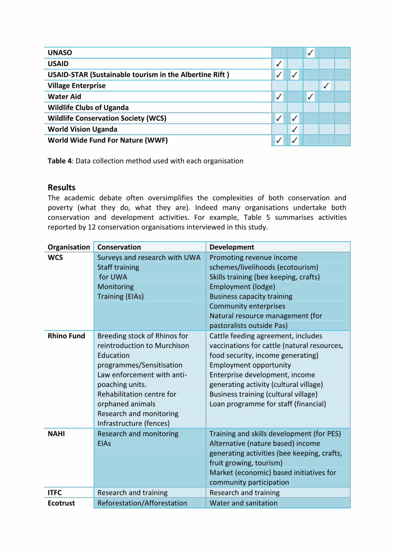
Table 4: Data collection method used with each organisation
Results The academic debate often oversimplifies the complexities of both conservation and poverty (what they do, what they are). Indeed many organisations undertake both conservation and development activities. For example, Table 5 summarises activities reported by 12 conservation organisations interviewed in this study.
Organisation Conservation Development
WCS Surveys and research with UWA Staff training for UWA Monitoring Training (EIAs)
Promoting revenue income schemes/livelihoods (ecotourism) Skills training (bee keeping, crafts) Employment (lodge) Business capacity training Community enterprises Natural resource management (for pastoralists outside Pas)
Rhino Fund Breeding stock of Rhinos for reintroduction to Murchison Education programmes/Sensitisation Law enforcement with anti-poaching units. Rehabilitation centre for orphaned animals Research and monitoring Infrastructure (fences)
Cattle feeding agreement, includes vaccinations for cattle (natural resources, food security, income generating) Employment opportunity Enterprise development, income generating activity (cultural village) Business training (cultural village) Loan programme for staff (financial)
NAHI
Research and monitoring EIAs
Training and skills development (for PES) Alternative (nature based) income generating activities (bee keeping, crafts, fruit growing, tourism) Market (economic) based initiatives for community participation
ITFC Research and training Research and training
Ecotrust Reforestation/Afforestation Water and sanitation

Land trust programme (they bought land to protect it) Education
Energy (renewable) Access to markets (Carbon market and agriculture) Credit schemes Enterprise development (forest-based) Employment (lodge) Land ownership Agricultural development (training and research of technologies)
CTPH Monitoring Animal vaccination
Family planning Sanitation, Hygiene (vaccinations against disease e.g. TB) Education on health/family planning Domestic animal vaccination Gender equality and women’s empowerment through family planning
CODECA Education/awareness Business development (management plans) Savings and loans association Improve access to financial institutions Capacity building (communities) Community Empowerment for Elimination of Child Labour in Tobacco
UWA Research and monitoring Rangers Infrastructure Education and awareness
Revenue sharing Natural resource access Income generating (sport hunting)
WWF Advocacy for conservation Research
civil society empowerment Advocacy for service delivery and access to markets (coffee growing) Alternative livelihoods (promoting coffee growing, ecotourism)
USAID-STAR Reforestation/Afforestation Infrastructure (elephant trenches)
Capacity building of enterprise (tourism) communities Marketing (improving access to international tourism market) Skills and business (e.g. accounting) training Constituency building (forming CBOs) Promote participation Grants for infrastructure
UCOTA Training Marketing, Capacity building, Advocacy Training (marketing) Income generating activities

FFI Training Capacity building Recognise and appreciate peoples cultural values Access to natural resource for cows (income generating, food security) Sanitation (soap)
Table 5: Activities of twelve conservation organisations surveyed Overall, if development activities are categorised as empowerment, wellbeing, finance, knowledge and emergency (based on other international frameworks for assessing poverty) and conservation activities as protection and management, then there is a huge overlap between the two sorts of organisations (Table 6)
Category Conservation Activities Development Activities
Empowerment Advocacy (for service delivery) Capacity building (tourism enterprise, community; business) Civil society empowerment Community participation Constituency building (forming CBOs) Gender equality and women’s empowerment Land acquisition and ownership
Advocacy (women’s land rights, improved education, resource allocation, school feeding programmes, water management facilities, national-level palliative care Support land rights cases for women Capacity building (school management, communities, businesses, for sustainable natural resource management) Rights (for children, women, people with HIV/AIDS, Strengthen civil society to advocate and hold public institutions accountable for education Participation (decision making processes, education) Encourage collaboration and networking Foster collaboration, networking, and strategic partnership among civil society organisations Community empowerment for business associated with natural resource based management Facilitate civil society participation in constructive dialogue
Well-being Market access (agricultural markets; Market access support

carbon markets; tourism markets) Access to natural resource for pastoralists Domestic animal vaccination Family planning Grants for infrastructure Hygiene (vaccinations against disease e.g. TB) Energy efficient stoves Increase agriculture production through reduced wildlife conflicts Land acquisition and ownership Infrastructure (social services e.g. schools, health units, educational centre, laboratories for schools) Natural resource management (for pastoralists outside Protected areas) Renewable energy Water and sanitation(drilling boreholes and spring protection), Woodlot establishment Problem animal management Improved nutrition by promoting backyard farming
Support school feeding programmes Water supply (rainwater harvesting, borehole, wells and springs construction) Promote forest-based livelihood strategies HIV/AIDS relief support Water hygiene and sanitation management, operation and maintenance (households and schools) Increase access to markets for farmers Problem animal management Finance the construction of infrastructure (e.g. factories, schools, hotels) Promote local innovations in agriculture and natural resources to improve food security Construct household latrines Renewable energy (focusing on biogas) Establish woodlots
Finance Carbon finance Community benefit sharing Credit schemes Economic incentives for maintaining private forests Employment opportunities in eco-lodge Formation of village savings and loans associations for communities, Income generating activities (goat rearing, coffee growing, beekeeping, piggery, vegetable growing, fruit growing, craft making, cultural village, fish farming, community trails, ecotourism) Loan programme Market (economic) based initiatives for community participation
Provide seeds, planting materials (and funds for) for farmers Facilitate diversification of livelihood sources (e.g. fish farming, beekeeping, goat rearing, fruit trees) Linking farmers to financial institutions Access to financial services through rotational saving and loans schemes. Financial savings and internal lending program for communities Improve access to financial institutions Income generating activities (goat rearing, beekeeping, fish farming, timber products) Savings and loans association Marketing, Promote local innovations in agriculture and natural resources

to improve household incomes Promote increased tourism associated income Formation of money lending institutions
Knowledge Training and research of technologies for agricultural development Education on health/family planning Training on fruit trees propagative methods Skills and business training (accounting) Skills training (bee keeping, crafts)
Train women on land rights Information generation and dissemination for education Training for advocacy and policy engagement Training, and provide sanitation for girls in schools Awareness on counterfeit seeds and access to agro-inputs and government services Training on agro-inputs Provide information on the impacts of climate change (on agriculture) Research linking management of natural resources to sustainable development HIV/AIDS education Training in enterprise development, Train, mentor and support care providers in palliative care First Aid training Provide a platform for exchange and sharing of strategic information and experiences among civil society organisations engaged in HIV/AIDS response
Emergency Technical support to disaster management activities
Protection Advocacy for environmentally friendly development Control of illegal hunting for bush meat in forest reserves Community sensitisation and awareness raising on conservation issues, Improved land management, Watershed protection, Collaborative natural resource management, Capacity building of Protected Areas
Community sensitisation (to minimize conflicts between park management and frontline communities) Educating the impacts of human activities on the environment, Natural resources management with emphasis on soil fertility management and integrating agro forestry Energy conservation, Promote good governance of

Authorities Provision of water to park edge communities to reduce communities entering parks. Human wildlife conflict reduction Conservation of water sources and harvesting, Advocacy for sustainable extraction of minerals in ecologically sensitive areas (e.g. oil exploitation and limestone mining in Kamwenge) Payments for ecosystem services schemes. Support anti-poaching patrols Environmental Impact Assessments Money from the community trail funds to improve protection of Gorillas and park resources Lobbying and awareness raising on chemical use in Uganda Law enforcement with anti-poaching units Conservation education Mobilizing resources for chimpanzee-focused environmental conservation Infrastructure (fences) Chimpanzee and habitat conservation through incentives for forest protection, alternative livelihoods activities, Forming private forest owners associations, Support private forest owners to acquire land titles Direct funding to conservation organisations through tourism Staff training for the Ugandan Wildlife Authority Promote incentives for alternative resource use strategies
protected areas and equitable sharing of conservation benefits and costs, Collaborative forest management Facilitated the formation of community based wetland management approaches. Education Awareness Promote the use of biogas in rural communities (to reduce pressures fuelwood) Awareness rising for forest and wetland conservation, Watershed protection from encroachment in Gravity Flow Schemes
Management Restoration of degraded ecosystems Research in natural forest conservation Reforestation/Afforestation , Wild animal vaccination Ecosystem restoration (forests and water catchments areas).
Reforestation/Afforestation Water resources conservation (e.g. water management trenches)

Indigenous tree nurseries for the restoration of degraded forested areas Wetland restoration on degraded areas Soil and water conservation Crane monitoring on identified sites Crane breeding documentation Breeding stock of Rhinos for reintroduction to Murchison Rehabilitation centre for orphaned animals Rescued chimpanzees sanctuary Capacity building of stake holder organizations in GIS and remote sensing Staff training for the Ugandan Wildlife Authority Surveys and research with Ugandan Wildlife Authority
Table 6: Activities carried out in the Western Administrative Region, by surveyed organisations. As well as an overlap in activities there is also an overlap in the geographical locations of conservation and development organisations’ work (Fig. 3). Conservationists predominantly focus to the west of the region, surrounding protected areas, in particular around three protected areas: Bwindi Impenetrable NP, northern Queen Elizabeth NP and Budongo CFR. Development project locations are more spread out over the entire region, although results show higher counts of organisations in sub counties surrounding and within Murchison Falls National Park, around Lake Albert and running down through Queen Elizabeth National Park. These areas have a relatively high proportion of the population living in poverty (>20%), however areas surrounding Lake Albert have relatively low poverty densities. Interview responses confirm that development organisations have more of a general approach in terms of locality, and that they use performance indicators to determine where to work. For example Water Aid reported that in order to choose the location of a project, they carry out an initial country review. This involves evaluating previous country strategies from the government, their performances, challenges and best practices. On completion, a final criteria is drawn, using national indicator such as water and sanitation statistics at district level, poverty status, budget allocation, health, conflict to identify the worst 30 districts, of which they concentrate on a select few (e.g. two). Within the chosen districts, they map out the most desperate sub counties, and within them, the parishes and villages. Conservation organisations however, tend to have a more restricted approach. Although there are some organisations – such as WCS – that have extended their focus to include areas outside protected areas, forming a landscape-scale approach to connect protected areas through private- and community-level forest management, the majority of

conservation organisations congregate around and within protected areas. Organisations reported that this is simply because that is where their niche is (Box 1).
Mapping organisations activities
Figure 3: The distribution of organisations’ activities within the Western Administrative Region, Uganda.
Box 1: Choosing locations for conservation and development work “Generally, the projects are usually initiated by a demand driven process whereby communities request for support in the various areas of interventions. Support is then extended depending on the available need which is usually assessed basing on coverage figures”, Agency for Cooperation and Research in Development (ACORD) “We are mandated to conserve biodiversity. Where do we find biodiversity? In the protected areas, in natural forests. That is why you don’t find us working in the central region, because there are no forests there”, ECOTRUST

Discussion The physical overlap between conservation and development organisations may imply that the two sectors are already working together. It is surprising to learn however, that there are disparities amongst conservation organisations as to whether development programmes in the Albertine Rift (Box 2). The main value of this pilot study is that it serves to highlight both the diversity and similarities within and between the priorities and activity content of organisations. Reviewing the conservation and development focus of specific activities – rather than focussing on the mission of the organisation as a whole - may improve or generate new collaboration/coordination/networking opportunities. The limited number of organisations surveyed only represents a fraction of the organisations working in the Albertine Rift. There are no other surveys similar to this one that exists; it therefore provides a starting point from which to continue. It includes the majority of the larger conservation organisations and most of the larger national organisations working in the Albertine Rift, and a mix of both larger international and smaller, national development organisations.
Box 2: Conservation views on development In areas where we have worked, there are very few [development] players, the other players who are there are also in conservation, but we have tried some efforts [to work with development organisations], which haven’t yielded. We […] wanted to promote coffee. […] We wanted to partner with [a national food marketing company] but they weren’t very interested in the areas we work. Access, there are no roads, so the big companies think no, not worth it. The infrastructure doesn’t exist in Albertine Rift is partly because that areas around nature reserves/parks are kind of ignored in most cases, WWF There are lots of development activities in the Albertine Rift, there are lots of economical activities, one, the oil extraction and production. So this is an area for conflicts from a result of bad economic development over land and things. We already see many people around who buy big chunks of land, so they can sell it. They have long term vision of establishing structures, Hoima will be an oil city, so big industries are trying to push out local communities; they buy them off and get big chunks of land NAHI

References Abulu, G. & Hassan, R. 1998. Agricultural productivity and natural resource use in South
Africa. Food Policy, 23 (6), 477–490.
Adams, W.M. & Infield, M. 2003. Who is on the Gorilla’s payroll? Claims on tourist revenue from a Ugandan national park. World Development, 31(1): 177-190.
Appleton, S., Emwanu, T., Kagugube, J. & Muwonge, J. 1999. Changes in poverty in Uganda, 1992–97. CSAE Working Paper Series, 99(22), CSAE, Oxford.
Archabald, K. & Naughton-Treves, L. 2001. Tourism revenue-sharing around national parks in Western Uganda: Early effort to identify and reward local communities. Environmental Conservation, 28(2): 135-149.
Bamutaze, Y. 2011. Geomorphology of Uganda. In: B. B. Bakamanume, ed. 2011. Contemporary Geography of Uganda. Dar Es Salaam: Mkuki na Nyota. Ch. 2.
Bird, K., McKay, A. & Shinyekwa, I. 2010. Isolation and poverty: the relationship between spatially differentiated access to goods and services and poverty. ODI/CPRC Working Paper Series (ODI WP322, CPRC WP162). London: ODI and Manchester: CPRC, University of Manchester
Blomley, T., Namara, A., McNeilage, A., Franks, P., Rainer, H., Donaldson, A., Malpas, R., Olupot, W., Baker, J., Sandbrook, C., Bitariho, R. & Infield, M., 2010. Development and gorillas? Assessing fifteen years of integrated conservation and development in south-western Uganda, Natural Resource Issues No. 23. IIED, London.
Brockington, D. & Scholfield, K., 2010b. The work of conservation organisations in sub-Saharan Africa. Journal of Modern African Studies, 48(1): 1-33.
Burgess, N., D’Amico Hales, J., Underwood, E., Dinerstein, E., Olson, D., Itoua, I., Schipper, J., Ricketts, T. & Newman, K., 2004. Terrestrial Ecoregions of Africa and Madagascar: A continental assessment. Island Press, Washington DC.
Buyinza, M. & Nyakaama, J.B. 2011. Forestry sector in Uganda’s national development. In: B. Bakamanume, ed. 2011. Contemporary Geography of Uganda. Dar Es Salaam: Mkuki na Nyota. Ch. 4.
Deninger, K. & Okidi, J., 2002. Growth and poverty in Uganda: Panel data evidence. Paper presented at CSAE conference, University of Oxford.
Hartter, J. & Ryan, S.J., 2010. Top-down or bottom-up? Decentralisation, natural resource management, and usufruct rights in the forests and wetlands of western Uganda. Land Use Policy, 27: 815-826.
IUCN & UNEP. 2009. The World Database on Protected Areas (WDPA). UNEP-WCMC. Cambridge, UK.
Kappel, R., Lay, J. & Steiner, S. 2005. Uganda: No more pro-poor growth? Development Policy Review, 23(1): 27-53.
Lepp, A. 2008. Attitudes Towards Initial Tourism Development in a Community With No Prior Tourism Experience: The Case of Bigodi, Uganda. Journal of Sustainable Tourism, 16(1): 5-22.
Marquardt, M.A., 1994. Settlement and Resettlement: Experience from Uganda’s National

Parks and Reserves, in: Cook, C. (ed.), Involuntary Resettlement in Africa, World Bank Technical Paper 227, Washington DC, 1994.
Matete, N. & Bakamanume, B.B., 2011. Climate of Uganda. In: B. B. Bakamanume, ed. 2011. Contemporary Geography of Uganda. Dar Es Salaam: Mkuki na Nyota. Ch. 1.
National Environment Management Authority. 2008. State of Environment Report for Uganda: Kampala, Uganda.
National Environment Management Authority, 2011. About NEMA [online] Available at: http://www.nemaug.org/about_NEMA.php [Accessed 17 February 2012].
Plumptre, A.J., Davenport, T.R.B., Behangana, M., Kityo, R., Eilu, G., Ssegawa, P., Ewango, C., Meirte, D., Kahindo, C., Herremans, M., Kerbis Peterhans, J., Pilgrim, J., Wilson, M., Languy, M. & Moyer, D. 2007a. The Biodiversity of the Albertine Rift. Biological Conservation, 134: 178-194.
Plumptre, A.J., Kujirakwinja, D., Treves, A., Owiunji, I. & Rainer H. 2007b. Transboundary conservation in the Greater Virunga Landscape: its importance for landscape species. Biological Conservation, 134: 279-287.
Roe, D. 2008. The origins and evolution of the conservation poverty debate: A review of key literature, events and policy processes. Oryx, 42: 491–503.
Sandbrook, C.G. 2010. Putting leakage in its place: The significance of retained tourism revenue in the local context in rural Uganda. Journal of International Development, 22: 124-136.
Uganda Bureau of Statistics. 2006. Uganda national household survey: Report on the socio-economic survey. [online] Kampala: Uganda Bureau of Statistics Available at: http://www.ubos.org/onlinefiles/uploads/ubos/pdf%20documents/UNHSReport20052006.pdf [Accessed 20 January 2012].
Uganda High Commission. 2009. Uganda Wildlife Authority [online] Available at: http://www.ugandahighcommission.co.uk/Tourism/UgandaWildlifeAuthority.aspx [Accessed 16 February 2012].
Uganda Wildlife Authority. 2012a. Community Conservation Programme [online] Available at: http://ugandawildlife.org/component/content/article/47-conservation-efforts/79-community-conservation# [Accessed 17 February 2012]
Uganda Wildlife Authority. 2012b. Lake Mburo National Park [online] Availabe at: http://www.ugandawildlife.org/national-parks/lake-mburo [Accessed 16 February 2012].
Uganda Wildlife Authority. 2012c. Murchison Falls National Park [online] Available at: http://www.ugandawildlife.org/national-parks/murchison-falls-national-park/56-murchison-falls-national-park [Accessed 16 February 2012].
Uganda Wildlife Authority. 2012d. Organisation Overview [online] Available at: http://www.ugandawildlife.org/uwa-overview [Accessed 16 February 2012].
Walpole, M. & Wilder, L. 2008. Disentangling the links between conservation and poverty reduction in practice. Oryx, 42(4): 539-547.