the precambrian metallogeny of kwazulu-natal · tugela terrane has been intruded by...
TRANSCRIPT

RHODES UNIVERSITY DEPARTMENT OF GEOLOGY
THE PRECAMBRIAN METALLOGENY OF KWAZULU-NATAL
BY
HETHENDRA GANGARAM HIRA
This thesis is submitted in partial fulfilment of the requirements for the degree of Master of Science
(Economic Geology), Rhodes University,
Grahamstown.
1998

ABSTRACT
The Precambrian rocks of KwaZulu-Natal comprise the Archaean granite-greenstone remnants of
. the Kaapvaal craton and Late Archaean volcanics and sediments of the supracratonic Pongola
Supergroup. These Archaean rocks have been intruded by numerous mafic/ultramafic complexes
and voluminous granitoid intrusives of various ages. To the south, the basement rocks are
represented by the Mid- to Late-Proterozoic Natal Metamorphic Province (NMP). The NMP
comprises three discontinuity-bound tectonostratigraphic terranes. These are, from north to south,
the Tugela, Mzumbe and Margate Terranes. The Tugela Terrane has been interpreted as an
ophiolite suite that was thrust northwards onto the stable Archaean craton as four nappe structures.
Continued thrusting resulted in the two southern terranes being thrust northwards over each other,
resulting in numerous sinistral transcurrent shear zones and mylonite belts. The greenschist facies
Tugela terrane has been intruded by mafic-ultramafic complexes, alpine serpentinites,
plagiogranites and a number of alkaline to peralkaline granitoids. The Mzumbe and Margate
Terranes comprise arc-related, felsic to mafic supracrustal gneisses and metasediments that were
intruded by syn-, late- and post-tectonic granitoids.
Mineralisation in the granite-greenstones consists of structurally-hosted lode-gold deposits. These
deposits have many characteristics in common with lode-gold deposits found in other granite
greenstone terranes throughout the world. The Nondweni greenstones also contain volcanogenic
related massive sulphide deposits. The Pongola Supergroup is host to lode-gold mineralisation and
placer gold mineralisation. These placer deposits have been correlated with deposits found in the
similarly-aged Witwatersrand Basin in an adjacent part of the craton.
The metallogeny of the NMP can be described in relation to the various stages in the tectonic
evolution of the belt. The initial, rifting and extension-related stage was characterised by arc
related magmatism and volcanic arc activity. Alkali basalt magmatism due to hot-spot activity in
the oceanic basin in which the Tugela Terrane initially accumulated, produced magmatic
segregation deposits, while volcanic-arc activity is responsible for the submarine-exhalative
massive sulphide mineralisation.
All the mineralisation within the NMP is structurally-related. These thrusts and shear zones were
developed during obduction and thrusting during the NMP event, and created the paths necessary
for the migration of mineralising fluids. Alpine-type ophiolite deposits were also emplaced along
these zones. Epigenetic, shear zone-hosted gold mineralisation occurs in the Tugela and Mzumbe
Terranes. Mineralisation occurs within quartz veins and is also disseminated within the sheared
host-rocks. The Mzumbe Terrane also contains small showings of massive sulphide deposits that
were related to volcanogenic exhalative processes during the formation of this terrane. Potential
for finding further mineralisation of this type appears to be good. The massive sulphide deposits
formed early in the evolution of the belt, and were deformed and metamorphosed during the later
accretionary processes. The southernmost Margate Terrane is characterised by a lack of
metalliferous mineralisation, but hosts the extensive, and economically important, limestone
deposits of the Marble Delta. The recently discovered spodumene-rich pegmatite deposits of this
terrane may also be considered for exploitation. Post-collisional magmatism and metamorphism
resulted in extensive rapakivi-type granite/charnockite plutons.

CHAPTER ONE l.Introduction
1.1. Definition 1.2. General
TABLE OF CONTENTS
PAGE
............................................................................................. 1 1
1.3. Previous Investigations ........................ ......................................................... 3 1.4. Aims of Present Study ................................................................................. 6
CHAPTER TWO 2. Geological Overview ............................................................................................. 8
2.1. The Archaean ....... .................... ..... ........... ........ ..... ..... ........................ ........ 14 2.1.1. Granite-Greenstone Basement ........... ... ........................... ............... 15
2.1.1.1. Commondale Formation ............................................. 15 2.1.1.1.1. Intrusives .......... ..... .............. ............... ..... ........ 17
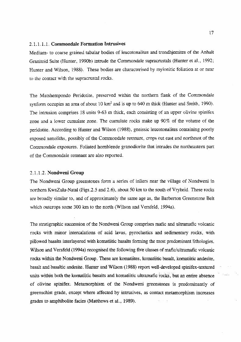
2.1.1.2. Nondweni Group ........................................................ , 17 2.1.1.2.1. Intrusives ......................................................... 20
2.1.1.3. Melmoth Granite-Greenstone Relic .................. ............... 20 2.1.1.3.1. Intrusives ......................................................... 21
2.1.1.4. Empangeni Group 2.1.1.4.1. Intrusives
2.1.1.5. Nzimane Inlier
......................................................... 21
......................................................... 22 22
2.1.2. Pongola Supergroup ...... ................ ........................ ................ ....... 24 2.1.2.1. Nsuze Group ..................................................................... 25 2.1.2.2. Mozaan Group ................................. ........... ............. 28 2.1.2.3. Pongola Supergroup Intrusives ................................. 29
2.2.The Proterozoic: Natal Metamorphic Province ............................................. 31 2.2.1. Tugela Terrane ................................................................................. 36
2.2.1.1. Natal Thrust Front ......................................................... 36 2.2.1.2. Nappe Zone: Tugela Group ............................................. 39
2.2.1.2.1. Nkomo Nappe ............................................. 39 2.2.1.2.1.1. Intrusiv-es ............................................. 39
2.2.1.2.2. Madidima Nappe ............................................. 42 2.2.1.2.2.1. Intrusives ............................................. 42
2.2.1.2.3. Mandleni Nappe ............................................. 42 2.2.1.2.3.1. Intrusives ............................................. 43
2.2.1.2.4. Tugela Nappe ......... ............ ............. ........... 44 2.2.1.2.4.1. Intrusives ............................................. 44
2.2.1.3. Matigulu Group ......................................................... 46 2.2.1.3.1. Intrusives ......................................................... 47
2.2.2. The Southern Terranes ......... _.......................................................... 48

2.2.2.1. Mzumbe Terrane: Mapumulo Group ..................... 48 2.2.2.1.1. Pre- and Syntectonic Intrusives ... .................. 50
2.2.2.2. Margate Terrane: Mzimkulu Group ................................. 51 2.2.2.2.1. Pre and Syntectonic Intrusives ..................... 53
2.2.2.3. Late- to Post-Tectonic Intrusives ................................. 54
CHAPTER THREE 3. Metallogenic Framework: The Archaean
3.1. Granite-Greenstone Terrane: Lode Gold ............................................. 58 3.1.1. Nondweni Group ..................................................................... 59
3.1.1.1. Golden Valley Mine ......................................................... 59 3.1.1.2. Nondweni Goldfield ......................................................... 61
3.1.1.2.1. Sisters Mine ................................. ...... ...... 63 3.1.1.2.2. Enterprise Mine ............................................. 64
3.1.1.3. Goodrickes Workings ............................................. 64 3.1.2. Melmoth Granite-Greenstone Remnant ................................. 65
3.2. Pongola Supergroup: Placer Gold Deposits ............................................. 67 3.2.1. Nsuze Auriferous Conglomerates ............................................. 67
3.2.1.1. North Syncline: Dickson Mine ................................. 67 3.2.1.2. Central Syncline: Central N suze Reef .......... ........... 68 3.2.1.3. South Syncline: Speedwell Mine ................................. 68 3.2.1.4. Coopers StorelRandalhurst ............................................. 68 3.2.1.5. Patsoana Prospect .......................... .................. .... ......... 68
3.2.2. Mozaan Auriferous Conglomerates ............................................. 69 3.2.2.1. Denny Dalton Mine ...................................... ... ............ .... 69 3.2.2.2. Gunsteling ... ............... ............................ ............ ..... ...... 70 3.2.2.3. Eldorado and Onverwacht ............................................. 70
3.3. Pongola Supergroup: Lode Gold Deposits ............................................. 70 3.3.1. Klipwal Gold Mine ..................................................................... 73 3.3.2. Wonder Mine and Ross Reef ......................................................... 76 3.3.3. Ngotshe Mine ................................................................................. 76 3.3.4. Other Lode Gold Prospects in the Pongola Supergroup 77
3.3.4.1. Mineralisation on the farm Kortnek ................................. 77 3.3.4.2. Mineralisation on the farm Bongaspoort .................... . 3.3.4.3. The Altona Prospect ...... _.,.~ .............................................. .
77 79
3.3.4.4. Haematite Reef ......................................................... 79 3.3.4.5. Bevenson Prospect 3.3.4.6. Breda Prospect
3.4. Other Metalliferous Deposits in the Greenstones ................................ . 3.4.1. Copper-Zinc Deposits .................................................................... .
3.4.1.1. Dania Mine .................................................................... . 3.4.1.2. Central Zone Prospect ............................................ . 3.4.1.3. St. James Mine
3.4.2. Tungsten
80 80
80 80 -81 83 83 85

3.4.3. Tin ............................................................................................. 85
3.5. Industrial Mineral Deposits: Granite-Greenstone Terrane 3.5.1. Talc ............................................................................................. 85 3.5.2. Graphite ................................................................................. 86
3.6. Industrial Mineral Deposits: Pongola Supergroup 3.6.1. Kyanite ............................................................................................. 86 3.6.2. Andalusite ................................................................................. 86 3.6.3. Corundum ................................................................................. 86
CHAPTER FOUR 4. Metallogenic Framework: The Proterozoic ......................................................... 87
4.1. The Tugela Terrane: ................................................................................. 89 THRUST FRONT 4.1.1. Shear Zone-hosted Lode Gold Deposits ................................. 90
4.1.1.1. Ngubevu Goldfield ......................................................... 90 4.1.1.2. Mfongosi Gold Mine ......................................................... 92 4.1.1.3. Nkunzana Gold Mine ............................................. 92
NAPPE ZONE 4.1.1.4. Phoenix Mine (Tugela Nappe) ................................. 94 4.1.1.5. Mpapala Goldfield (Madidima Nappe) ..................... 94
4.1.2. Gold-bearing Massive to Semi-massive Sulphides ......... ....... ..... 95 4.1.2.1. i'Thuma Volcanogenic Sulphide Deposit ..................... 95
4.1.3. Base Metal and Other Mineralisation ............................................. 97 4.1.3.1. Ngubevu Cu-Zn ......................................................... 97 4.1.3.2. Mfongosi Pb-Ag ......................................................... 97 4.1.3.3. Mfongosi Cu-Ag ......................................................... 97 4.1.3.4. Magmatic Ores ......................................................... 98
4.1.3.4.1. Sithilo Complex: Cr ................................. 98 4.1.3.4.2. Tugela Rand Layered Suite: Cr ..................... 100 4.1.3.4.3. Sebenzani Cu-Ni Sulphides ..................... 100 4.1.3.4.4. Mambula Complex: Fe-Ti-V ..................... 101
4.1.4. Alkaline Complexes ..................................................................... 102 4.1.4.1. Wangu Granitoid Gneiss -' "............................................. 102 4.1.4.2. Bull's Run Complex ......................................................... 103 4.1.4.3. Ngoye Complex ......................................................... 103
4.1.5. Industrial Mineral Deposits 4.1.5.1. Bull's Run Complex Mineral Fluxes ..................... 105 4.1.5.2. Ngoye Complex Glass Aggregate ................................. 106 4.1.5.3. Potentially Exploitable and Minor Deposits ........ ............. 107
4.2. The Mzumbe Terrane ................................................................................. 109 4.2.1. Urnzinto Goldfield: Shear Zone-hosted Gold ............. ........ ....... ..... 110 4.2.2. W-Mo in Ca-rich Granites
4.2.2.1. Mvoti Valley ..................................................................... 113 4.2.2.2. Umzinto ..................................................................... 114
4.2.3. Cu-Mo in Granitoids ..................................................................... 114 4.2.4. Cu-Ni in Ultramafic Rocks ..................................... .................... 115 4.2.5. U-Th in Pegmatites and Alaskites ............................................. 115 4.2.6. Base Metal Investigations at Lilani ............................................. 116 4.2.7. Industrial Mineral Deposits ......................................................... 116
4.2.7.l. Dimension Stone ......................................................... 117 4.2.7.2. Kaolin Derived from Proterozoic Granites ..................... 118 4.2.7.3. Deposits with Uncertain Economic Potential 120
4.3. The Margate Terrane ................................................................................ . 122 122 123 123 125 125 126 128
4.3.1. Tonjeni Au Occurrence ........................................................ . 4.3.2. Bomela Gold ................................................................................ . 4.3.3. Lithium-bearing Pegmatites ........................................................ . 4.3.4. Industrial Mineral Deposits ........................................................ .
4.3.4.1. Marble: Marble Delta Limestone ................................ . 4.3.4.2. Dimension Stone 4.3.4.3. Deposits with Uncertain Economic Potential
CHAPTER FIVE 5. Metallogeny of the Precambrian deposits
5.1. The Archaean ............................................................................................. 129 5.1.1. Lode Gold Mineralisation ......................................................... 129
5.1.1.1. Genesis of Structurally-hosted Lode Gold Deposits ......... 132 1] Source of the Gold ......................................................... 133 2] Source of the Mineralising Fluids and Transport ......... 135 3] Mechanisms of Concentration in Fluids ..................... 138 4] Structure and Wall rock Alteration ..................... 138 5] Cause of Au Precipitation ... .... ................. .............. ....... 141 6] Timing .............................................................. ....... 142
5.1.1.2. Lode-Gold deposits in KwaZulu-Natal ..................... 143 5.1.1.2.1. Granite-Greenstone Terrane ..................... 143 5.1.1.2.2. Pongola Supergroup ................................. 145
5.1.2. Placer Gold ................................................................................. 146 5.1.3. Archaean Volcanogenic Massive Sulphide Deposits ..................... 150
5.2. The Proterozoic: Natal Metamorphic Province ............................................. 151 5.2.1. Mineralisation and Tectonic Evolut.ion ................................. 151
5.2.1.1. Magmatic Segregations ............................................. 153 5.2.1.2. Volcanogenic Exhalatives ............................................. 154 5.2.1.3. Granite-related Deposits ............................................. 157
5.2.1.3.1. Alkaline Granites ............................................. 157 5.2.1.3.2. Li-bearing Pegmatites ................................. 157
5.2.1.4. Epigenetic Deposits ......................................................... 158
CHAPTER SIX 6. Summary and Conclusions ............................................................................................. 159
6.1. The Granite-Greenstone Terrane ..................................................................... 159

6.2. The Pongola Supergroup ................................................................................. 160 6.2.1. Placer deposits ............. '" .............. ... ....... ............. ...... ............ .......... 160 6.2.2. Lode Gold Deposits ..................................................................... 160
6.3. The Natal Metamorphic Province ......................................................... 160 6.3.1. Magmatic Segregations and Ophiolites ................................. 161 6.3.2. Volcanogenic Exhalatives ......................................................... 161 6.3.3. Granite-related Deposits ...................................................... '" 162 6.3.4. Epigenetic Deposits .............................. .......... ......... ...... .............. 162
6.4. The Mineral Potential of KwaZulu-Natal ............................................. 162 6.5. The Benefits of Metallogenic Mapping ......................................................... 165
7. Acknowledgements ............................................................................................. 167 8. References ............................................................................................ ......................... 168
LIST OF FIGURES
Figure 1.1: Outline of the KwaZulu-Natal Province showing the extent covered by the various 1 :250 000 maps under investigation.
Figure 1.2: Areas covered in the Special Issue of the S.A. Journal of Geology on Proterozoic rocks of the NMP.
Figure 2.1: Regional tectonic setting of the Namaqua-Natal Province and the position of the Natal Metamorphic Province in a Gondwana context (after Thomas et al., 1992a).
Figure 2.2: Distribution of the Natal Group and Msikaba Formation in KwaZulu-Natal (after Thomas et al., 1992e).
Figure 2.3: Distribution of the Karoo Supergroup in KwaZulu-Natal (after the 1: 1 000000 Geological Map published by the Geological Survey (1984).
Figure 2.4: Map showing the outcrop of the Barberton greenstone belt and smaller greenstone fragments to the south (after Wilson and Versfeld, 1994a).
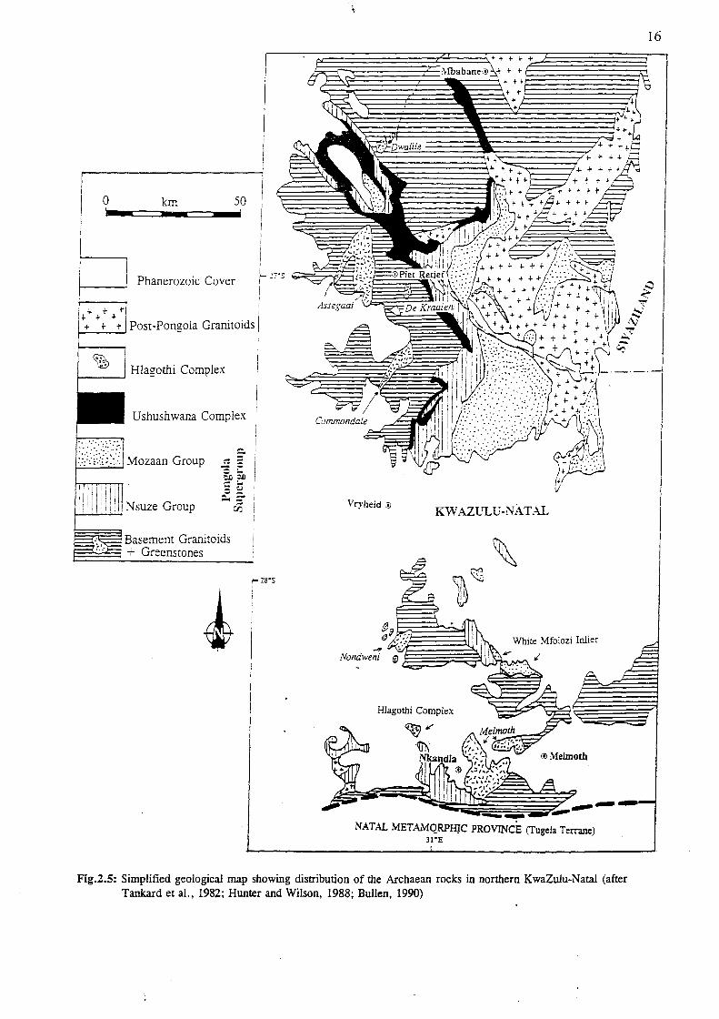
Figure 2.5: Simplified geological map showing distribution of the Archaean rocks in northern KwaZulu-Natal (after Tankard et aI., 1982; Hunter and Wilson, 1988; Bullen, 1990).
Figure 2.6: Exposures of the Nondweni Group and its constituent Formations (after Wilson and Versfeld, 1994a).
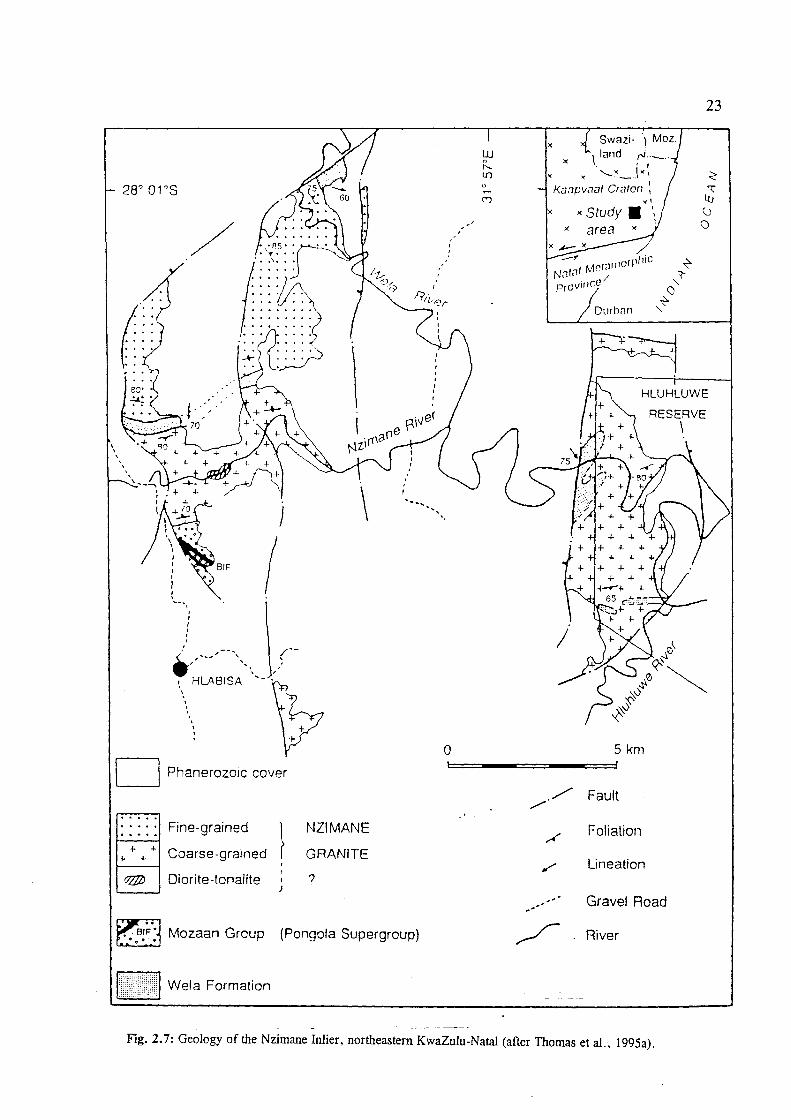
Figure 2.7: Geology of the Nzimane Inlier, northeastern KwaZulu-Natal (after Thomas et aI., 1995a).
Figure 2.8: Simplified stratigraphy of some inliers of the Pongoia Supergroup (after Burke eta!.,1985).
Figure 2.9: Major tectonic subdivisions, thrust directions and transcurrent shear zones of the NMP (after Matthews and Charlesworth, 1981; Thomas, 1989a; Jacobs et aI., 1993).
Figure 2.10: Schematic cross-section of the Natal Metamorphic Province (after Thomas et aI., 1994b).
Figure 2.11: Block diagrams illustrating the possible tectonic evolution of the NMP terranes (after Jacobs and Thomas, 1994).
Figure 2.13: Simplified tectonic map showing subdivisions of the Tugela Terrane (after Matthews and Charlesworth, 1981).
Figure 2.14: Distribution of the Bulls Run Complex, Wangu Gneisses, Ngoye Complex and Halambu Formatiom gneisses within the Tugela Terrane (from Scogings, 1989a; 1991b).
Figure 2.13: Lithologic subdivisions of the Tugela Rand Layered Suite (after Wilson, 1990). Figure 2.14: Distribution of the Mapumulo Group with. constituent formations only shown
from the south of Durban (after Thomas, 1992a). Figure 2.15: Distribution of the Mzimkulu Group and its constituent formations (after
Thomas, 1992b). Figure 2.16: Mzumbe and Margate Terrane Intrusives (after Thomas, 1990b,c,d;
1991a,b,c,d; 1992a,b,c) Figure 2.17: Distribution of the Oribi Gorge Suite, with informal pluton names (after
Thomas, 1991e).

Figure 3.1 :
Figure 3.2 :
Figure 3.3 :
Figure 3.4 :
Figure 3.5 :
Figure 3.6 : Figure 3.7 :
Figure 4.1 :
Figure 4.2 :
Figure 4.3 :
Figure 4.4 :
Figure 4.5 :
Figure 4.6 :
Figure 4.7 :
Figure 4.8 :
Figure 4.9 :
Figure 4.10:
Figure 4.11 :
Figure 4.12: Figure 4.13:
Figure 4.14:
Figure 4.15:
Gold occurrences in the Archaean rocks of KwaZulu-Natal, south of the Pongola River (after Bullen et aI., 1994). Mineral occurrences in the vicinity of Nondweni, northern KwaZulu-Natal (after Versfeld, 1988). Gold occurrences hosted in the Mozaan Group in northeastern KwaZulu-Natal (after Brown, 1989). Location of the Klipwal Mine and Geology of the Klipwal shear zone (from Gold and Von Veh, 1995) Geology and distribution of the Toggekry Formation (Nondweni Group) and Locations of the Dania Mine and St.James Mine (after Wilson and Versfeld, 1994a). Sections through the Dania Mine Workings (after Hatch, 1910). Section through the St. James Mine Interpreted from surface exposure and diamond drilling (from Wilson and Versfeld, 1994a).
Location of the important known metalliferous mineral occurrences in the NMP (after Thomas et aI., 1994b). Metalliferous mineral deposits within the Tugela Terrane (after Thomas et aI., 1990a). Geology of the western part of the Natal Thrust Front showing the Ngubevu Mineral Occurrences (after Thomas et aI., 1990a). Schematic cross-section through the Nkunzana Mine workings showing the grades acheived at various intervals (obtained from the Government Mining Engineer, Johannesburg, by Thomas et aI., 1990a). Geology of the area surrounding the i'Thuma massive-semimassive sulphide body (after Thomas et al., 1990a). Geological setting of the ultramafic bodies within the Tugela Terrane (after Wuth and Archer, 1986). Geological Map of the Ngoye Complex showing sample localities (after Bullen et aI., 1992). Geological Map of the Bull' s Run Complex showing localities for samples analyzed in Table 4.4 (after Bullen et aI., 1992). Map of the Tugela Terrane Industrial Mineral Occurrences, with talc occurrences shown in black (after Bullen et aI., 1992). Metalliferous Mineral Ocurrences in the Mzumbe Terrane (modified after Thomas et aI., 1990a). Location of the Umzinto Goldfield Workings in Southern KwaZulu-Natal (after Thomas and Gain, 1989). Industrial Mineral Occurrences in the NMP. (after Bullen et al., 1992). Proterozoic Granite-derived Kaolin occurrences in the Inanda-Ndwedwe area of KwaZulu-Natal (after Heckroodt, 1992). Metalliferous Occurrences in the Margate Terrane. Gold Deposits of the Mzumbe Terrane are also shown (after Bullen et al., 1992). Regional geological setting and location of the Li-bearing Pegmatites (after Thomas et al., 1994a).

Figure 4.16:
Figure 4.17:
Figure 5.1 : Figure 5.2 :
Figure 5.3 :
Figure 5.4 :
Figure 5.5 :
Figure 5.6 :
Figure 5.7 :
Figure 5.8 :
Figure 5.9 :
Geology of the Mucklebraes Klippen Structure and Highbury Pegmatite (after Thomas et aI., 1994a). Detailed Geological Map of the Marble Delta Area, Southern KwaZulu-Natal (after Otto, 1977).
Major sources of world gold production (after Groves and Phillips, 1987). Schematic crustal profile of a hypothetical, continuous hydrothermal system over a crustal range of 25 km (after Groves, 1993). Schematic diagram showing the transportation of mineralising fluids through the crust via a major structural discontinuity into second-order subsidiary structures (after Eisenlohr et aI., 1989). Schematic representation of the metamorphic-replacement model for the generation of Archaean gold deposits (after Groves and Phillips, 1987). Simplified sketch-map of possible greenstone belt evolution and mineralisation in northern KwaZulu-Natal (modified after Bullen, 1990). Present-day extents of the Witwatersrand and Pongola Basins on the Kaapvaal Craton (after De Wit et aI., 1992). Stratigraphic correlations of the Witwatersrand and Pongola Supergroups (after Beukes and Cairncross, 1991). Initial stages in the development of the NMP Terranes. Some intrusives are also shown. (after Thomas et aI., 1995b). Cross-section of a modern sea-floor hydrothermal system, showing the principal components (after Herzig and Hannington, 1995).

Table 2.1 : Table 2.2 : Table 2.3 : Table 2.4 : Table 2.5 : Table 2.6 : Table 2.7 : Table 2.8a: Table 2.8b: Table 2.9 : Table 2.10: Table 2.11: Table 2.12: Table 2.13: Table 2.14: Table 2.15: Table 2.16: Table 2.17: Table 2.18:
Table 3.1 :
Table 3.2 : Table 3.3 :
Table 3.4 :
Table 4.1 : Table 4.2 : Table 4.3 : Table 4.4 : Table 4.5 : Table 4.6A: Table 4.6B: Table 4.7 : Table 4.8 : Table 4.9 : Table 4.10: Table 4.11:
LIST OF TABLES
Subdivisions of the N ondweni Group Subdivisions of the Empangeni Group Predominant N suze Group Lithologies The N suze Group in the Nkandla area Regional Stratigraphy of the N suze Group Provisional Subdivision of the Mozaan Group Ntingwe Group lithologies Mfongosi Group - Western Sector Mfongosi Group - Eastern Sector Nkomo Nappe Formations and Lithologies Madidima Nappe Formations and Lithologies Mandleni Nappe Formations and Lithologies Tugela Nappe Formations and Lithologies Matigulu Group Formations and Lithologies Mapumulo Group Formations and Lithologies Pre- and Syntectonic Intrusives of the Mzumbe Terrane Mzimkulu Group Formations and Lithologies Margate Terrane Pre- and Syntectonic Intrusives Late- to Post-tectonic Intrusives of the Mzumbe and Margate Terranes
Characteristics of some Archaean Greenstone Belt Gold Deposits of KwaZuluNatal. Characteristics of the Sulphide-bearing zones at Goodricke's Workings. Summary of available production statistics for greenstone-hosted lode-gold deposits in KwaZulu-Natal. Characteristics of some Archaean Lode Gold Deposits in the Pongola Supergroup.
Characteristics of the N gubevu Gold Deposits Characteristics of the Mpapala Goldfield Workings Mineralisation grades in the southern part of the Ngoye Complex Comparison of Bulls Run Mineral fluxes with those currently exploited overseas Potentially exploitable and minor deposits within the Tugela Terrane. Characteristics of the Dumisa Sector Workings. Characteristics of the Inyangaleza Sector Workings. Potential Dimension Stone Lithologies in the Mzumbe Terrane. Properties of two Kaolin Deposits in the Inanda-Ndwedwe Area. Industrial Minerals in the Mzumbe Terrane with Uncertain Economic Potential. Potential Dimension Stone Lithologies in the Margate Terrane. Industrial Minerals in the Margate Terrane with Uncertain Economic Potential;

l.INTRODUCTION
1.1. Definition
CHAPTER ONE
1
Metallogeny has been defined by Guild (1972) as: "The study of the genesis of ore deposits
in their total geologic environment. Metal in this sense derives from a Greek word meaning
mine; thus metallogeny treats of both metallic and nonmetallic minerals. The fossil fuels are
commonly excluded. "
Metallogenic studies are considered most important for exploration as even though genetic
interpretations may prove incorrect, documentation of the field characteristics from known
mineral deposits can provide the first step in the exploration for new deposits where analogous
situations exist.
1.2 General
The area studied (Fig. 1.1) is bound by latitudes 2r20'S, 31 °30'S and longitudes 30 0 30'E,
30°32' E, which is included in part of the following 1:250000 map sheets: 2730 (Vryheid),
2830 (Dundee and Richards Bay), 2930 (Durban) and 3030 (Port Shepstone).
Due to the contrasting underlying lithologies there is great variation in the topography of the
study area from west to east. The plateau in the east is covered by rolling hills and grassland
which is underlain by sandstone and shale of the Karoo Supergroup. Extensive intrusions of
Karoo dolerite generally alter the relief of the area in the form of more resistant sills and
dykes. Fault-bounded rocks of the Karoo Supergroup also outcrop before the narrow coastal
strip in the east. This area is intensively cultivated.
In the central part of the area more resistant quartz-arenites of the Natal Group have been
extensively block-faulted to produce horst and graben structures. This lithology generally
forms elevated cliffs adjacent to the Karoo rocks and the variably resistant rocks of the Natal
Metamorphic Province (NMP).
The basement rocks of the NMP crop out in the form of inliers which trend subparallel to the .
coastline and displays a rugged topography that is deeply dissected. The steep, deeply eroded
valleys are sparsely inhabited and cloaked in dense thombush, which makes access difficult.
Only subsistence farming is practised here by the local inhabitants.

Free State
Eastern C:1pe
Mpumalanga
Sheer 2730 Vryheid
I
28°S --
I
Sheer 2830 Dundee and Richards Bav ® Dundee
29°S _.- - - - - -I ! Sheer 2930 Durban
®Pietermaritzburg
2
MOZ!lll1bique
SWlIzilllnd
/
/ ,- (
.:1) Pongola V~
I ;' !
I
r
7 /
I
'. Du,b,n J 30'S iSh';;-3030 Pan Sh,pSlan; f- ---,....-_____ 3_2"'7"°E _____ -=-__ ~__,
I
®Port Shepstone
o I
~ \un
31°E 50
RE?UBUC
OF
SOUTH AFRICA
Fig.i.l: Outline of the KwaZulu-Natal province showing the extent covered by the various 1:250000 geological maps under investigation.

3
The coastal strip is easily accessible and large parts of this belt, on hills as well as the flat
plains, are covered by extensive sugar cane plantations.
The climate is subtropical in the coastal areas with hot, humid summers and moderate, dry
winters, which has enhanced the tourism potential of these areas. However, because of the
increased altitudes of the inland areas, frost is common in winter. This has led to extreme
chemical weathering, especially of basement rocks, restricting outcrops to the actively eroding
stream and river beds.
The drainage in K waZulu-N atal is well developed, with several river systems in the north,
central and southern areas which run southeast from the highlands to the ocean, deeply
dissecting the rugged topography and forming deeply incised valleys.
1.3 Previous Investigations
Much geological work has been carried out in the KwaZulu-Natal province since the early
1900' s. Many workers have concentrated on the Archaean rocks in the north and the
Proterozoic basement rocks of the NMP, which are the most interesting from a metallogenic
point of view. Studies describing the entire Namaqua-Natal Mobile belt have been put into
context with evolution of the southern part of Africa as a whole.
Until recently, there was a general lack of geological interest in this region as no significant
deposits of metalliferous mineralization existed, in- contrast to the western Namaqua sector of
the belt, from which numerous mineral deposits are exploited. Apart from the successfully
exploited heavy mineral sands deposits in the vicinity of Richards Bay and the KIipwal golcl
mine near Pongola, there are a few other small gold mines and prospects that have been
worked in the past and produced a small quantity of gold. Other deposits that may have
exploitation potential include chrome, vanadium and numerous industrial mineral deposits:
Many obstacles have hindered exploration projects in the Province, particularly the inaccessible
mountainous terrain, dense natural vegetation cover and poor outcrop;·Uoweverw4thmodem
advances in exploration techniques, new potential may be realised.

4
A list of some of the more important contributors involved in describing the mineralisation
within the Province and also a short description of their work is given below.
Hatch (1910) was the first to give detailed assessments of the most important mineral resources
in the entire province known at the time. A brief description of the geology as well as chemical
assays were also undertaken. Many later studies were based on these initial investigations.
Later, Du Toit (1920, 1931, 1946) compiled various geological maps and explanation sheets
throughout the then Colony of Natal. Lithological and mineralisation descriptions were
markedly accurate and still used as a basis for compiling maps.
Matthews (1959,1972,1981a) was instrumental in documenting the geology of the northern
margin of the Natal Metamorphic Province and suggested the ophiolite theory for this area.
Together, Matthews and Charlesworth (1981) produced a map of the northern margin for the
National Geodynamics Project. Matthews (1990) also proposed a plate-tectonic model for the
Pongola Supergroup in northern KwaZulu-Natal. Thomas (1989a) and Thomas et al. (1990a;
1994b) researched many papers on the Natal Metamorphic Province concentrating on mineral
deposits in the area and their genesis. Thomas (1988b) also compiled the 1 :250 000 Port
Shepstone and Durban sheets and was instrumental in revising the subdivisions of the NMP
into the three distinct tectonostratigraphic terranes now recognised. With various co-workers,
he analyzed and unravelled much of the tectonic evolution and lithological details in the
KwaZulu-Natal province.
Wuth & Archer (1986) suggested that the Sithilo ore body in the Tugela Terrane, which was
mined on a limited scale in the early 50's for high grade chrome concentrates, was the
Precambrian equivalent of an alpine-type ophiolitic chro~te deposit. Reynolds (1986) studied
the titaniferous ores of the Mambula layered mafic complex and suggested that it formed by
the fractional crystallization of a mafic magma.Scogings (e.g. 1985, 1986, 1989a) researched
various aspects of the peralkaline intrusives in the northern part of the Natal Metamorphic
Province.
Beukes and Cairncross(1991) provided detailed correlations between the Mozaan Group in
northern K waZulu-Natal and Witwatersrand Supergroup lithologies of the Gauteng and

5
Mpumalanga Provinces.
Numerous contributions to the geology of the Archaean rocks were made by Armstrong et
al. (1982, 1986), Wilson and Carlson (1989) and Watchorn (1980a,b).
Also relevant to this study are various papers on the evolution of the Namaqua-Natal Mobile
Belt and the special issue of the South African Journal of Geology (Vol.92(4), 1989) which
concentrated on problematic areas of the Proterozoic rocks in the Province (Fig. 1.2).
0'" ....
q .., /'):
Eglington. Kerr &
Thomas & Gain
Thomas 2
Thomas 1
-&. '\
o
I I , ,
7 I I ,
" DURBAN ,.
Eglington & Kerr
& Strydom
& Grantham
~. 50 Km <"
---~, \
Fig.1.2: Areas covered in the Special Issue of the S.A. Journal of Geology on Proterozoic rocks of the NMP.
The South African Development Trust Corporation (STK) were also active in exploration for
new deposits in many of the undeveloped parts of the province and many of their reports are
available at the Geological Survey of South Africa in Pretoria. Various mining companies
6
known to currently have exploration progranunes in the Province, however no details have yet
been released.
Important contributions to the geology and mineralisation within the study area were obtained
from various M.Sc and Ph.D theses, e.g. Otto (1977), Charlesworth (1981), Evans (1984),
Versfeld (1988), Bullen (1990), Gold (1993), etc.
The Geological Survey of South Africa has produced four 1 :250 000 geological map sheets and
explanation booklets in the late 1980's covering the area and the stratigraphic nomenclature
used in the text is largely based on these maps and the explanation booklets by Linstrom
(1987a,b,c) and Thomas (1988b).
1.4 Aims of Present Study
This study was initiated by the Economic Geology Division of the Geological Survey of South
Africa who are currently involved in the production of 1 :250 000 scale metallogenic maps
covering various parts of South Africa. All information derived from research, including field
investigations is captured on SAMINDABA (South African Mineral Deposits Data Base) using
the Oracle computer progranune. Information may then be called up to produce maps showing
the exact location of mineral occurrences, size of deposits, associated mineralisation, host
lithologies, orientation of ore-bodies, depositional environments etc. Metallogenic maps of
sheets 2830 (Dundee and Richards Bay), 2930 (Durban) and 3030 (Port Shepstone} Sheets are
in advanced stages of compilation and data is in the process of being captured. These sheets
will also be digitised and will show the simplified geology and depositional environments of
the host lithologies.
A brief description of the Precambrian lithologies and related intrusives in chapter two
provides a geological overview to the rocks hosting the mineral occurrences~. The object of this
investigation is to document the mineral occurrences (chapters three and four) and classify the
important metalliferous occurrences according to ore deposit mQdels~ This classification will
then be used to assess the depositional environments, tectonic settings and other relevant
characteristics of deposits within the study area. These characteristics will then be compared
to those of similar deposits that have been analysed in published literature (chapter five) to

7
provide a better understanding the metallogeny of the study area and aid in the exploration for
other deposits in similar geological settings.
The contents of this thesis will form part of the explanation booklets to accompany the
metallogenic maps mentioned above. These explanation booklets will also include descriptions
of all the known Post-Proterozoic mineral deposits that occur in KwaZulu-Natal.

8
CHAPTER TWO
2. Geological Overview
Introduction
The oldest rocks recognised in the study area belong to two major tectonic provinces, the
Archaean Kaapvaal Craton and the Mid- to Late-Proterozoic Natal Metamorphic Province
(NMP). The southeastern portion of the Kaapvaal Craton is exposed in the northern parts of
KwaZulu-Natal to as far south as the Natal Thrust Front as various inliers and constitutes a
typical granite-greenstone terrane with ages of up to 3.64 Ga (Compston and Kroner, 1988).
Each of these remnants is lithologically distinct and comprise volcanic rocks (ranging in
composition from komatiites to basalts) and clastic and chemical sediments (Hunter and
Wilson, 1988).
Unconformably overlying the granite-greenstones of the southeastern Kaapvaal Craton, are the
volcanics and metasediments of the Pongola Supergroup, which is exposed in northern
KwaZulu-Natal, Mpumalanga Province and southern Swaziland. This Late-Archaean (± 2.94
Ga, Hegner et ai., 1984) supracrustal sequence is one of the oldest to have developed on a
craton, and thus serves to confirm the early stabilisation of the Kaapvaal Craton. The Pongola
Supergroup comprises volcanics of the Nsuze Group and overlying arenites, argillites and iron
formations of the Mozaan Group. Studies by Matthews (1990) revealed that the Nsuze Group
was deposited in response to rifting within an epicratonic basin, while the Mozaan Group
developed in a post-rift, subsidence basin.
Precambrian rocks to the south of the craton belong to the NMP, which has been dated at
between ± 1 250 and ± 950 Ma (Eglington et aI., 1989; Thomas and Eglington, 1990) and
forms part of the Namaqua tectonic event sensu stricto_{Gibson et al., 1996) although it was
previously included as the late part of the Kibaran sensu lata (Thomas et aI., 1994b). The
boundary between the two tectonic provinces in K waZulu-N atal is a zone of imbrication known
as the Natal Thrust Front, where the northern margin of the NMP has been interpreted as an
ophiolite complex that was obducted onto the southern margin of the Kaapvaal Craton as four
major flat-lying thrust nappes (Matthews, 1972).

9
The NMP fonns the eastern sector of the Namaqua-Natal Metamorphic Province which is a
200 - 400 km-wide, easterly to east-southeasterly-trending belt of complexly defonned and
metamorphosed rocks adjacent to the southern and southwestern margin of the Kaapvaal Craton
(Fig. 2.1). The outcrops in Namaqualand are separated from those in KwaZulu-Natal by a
thick cover of Phanerozoic Karoo sediments. Similar isotopic ages and structural histories
however, indicate that a continuous belt exists (e.g. Nicolaysen and Burger, 1965; Jacobs et
aI., 1993).
Furthennore, a variety of geophysical methods have been used to precisely map the position
of the belt under cover and its relationship to the Kaapvaal Craton and the Kheis Province in
Namaqualand (e.g. De Beer and Meyer, 1984; Comer et aI., 1990; Barkhuizen and Matthews,
1990; Thomas et aI., 1992c). Within a Gondwana context, apart from the westward
continuation of the NMP into N amaqualand, the rocks have also been equated to the east with
those of similar geological characteristics in the Falkland Plateau (Adie, 1952; Rex and
Tanner, 1982; Martin and Hartnady, 1986; Mitchell et aI., 1986); the Western Dronning
Maudland in Antarctica (Grantham et aI., 1988), and also northwards into the N-S-trending
Mozambique Belt (Thomas et aI., 1994b) (Fig. 2.1).
Central and southern KwaZulu-Natal are characterised by outcrops of the NMP, which has
been subdivided by Thomas (1989a) into three discontinuity-bounded tectonostratigraphic
terranes. These are the Tugela Terrane in the north, and the central and southern Mzumbe and
Margate Terranes. Metamorphic grades increase from greenschist facies in the north to
granulite facies in the south. The southern margin of the NMP is not exposed. The pretectonic
Sikombe Granite recognized south of the Margate Terrane in the Eastern Cape however, is
thought to represent the exposed fragment of a fourth testonic domain (Thomas and Mawson,
1989). The Mzumbe and Margate Terranes are intruded by distinctive pre- and syntectonic
plutonic suites. Late-tectonic granitoids however, crop out throughout-the two southern
terranes. Intrusives identified in the Tugela Terrane supracrustal rocks-include plagiogranites,
mafic-ultramafic complexes and serpentinites (Matthews, 1972) and a-number of alkaline to
peralkaline granitoids (Scogings, 1989a).

o CAPE FOLD BELi (-280 Mal
ri··:.::·:1 PAN AFRICAN OROGENS (-500 Mal
[./.'j KIBARAN OROGENS (-1 000 Mal REWORKED • ..-<.-1 DURING PAN AFRICAN (-500 Ma)
/ ft .. , ........
/' ./
0
KIBARAN OROGENS
E3URNIAN PROVINCE:S (-2000 Mal
ARCHAEAN CRATONS AND M081LE 8ELiS
Thrusts
Shear zones
Magnetic anomalies
500 m isobath (East Antarctica)
500 km
10
LOCALITY MAP
Fig.2.1: Regional tectonic setting of the Namaqua-Natal Province and the position of the Natal Metamorphic Province in a Gondwana Context (after Thomas et aI., 1992a).

11
The NMP is unconformably overlain by Lower Ordovician red-bed Natal Group sandstones
in the north and pale grey, fossiliferous, marine Devonian quartz arenites of the Msikaba
Formation south of 30 0 30'S (Thomas et aI., 1992e). The change in lithology was found to
occur abruptly on either side of the Dweshula Basement High (Thomas et aI., 1990c), which
is an area of non-deposition of the sandstone lithologies in southern KwaZulu-Natal (Fig. 2.2).
The Msikaba sandstones were deduced to have been deposited in a near-shore shallow marine
environment, with the sediments having a provenance area in the northeast (Visser. 1974;
Hobday and Mathew, 1974; Kingsley, 1975). Thomas et al. (l992e) concluded that: "the rocks
of the Natal Group represent a continental, post-orogenic mollase deposit, derived from the
rapid erosion of a rising Pan-African mountain chain situated to the east of present day Natal.
and laid down by fluvial systems in an adjacent fault-bounded trough."
JO·'
I J1· ,
I • I!/.I!M1
_ ;9·S
aUR8AN 30· S
t>:;~ Hsikaba Forma/ion
OWt!shufa bast!mt!nf high axis
F' 2 2'D' tr'b tion of the Natal Group and Msikaba Formation in KwaZulu-Natal_(after Thomas et al .• 1992e). Ig ••• IS 1 U

12
The older sandstones are overlain by Carboniferous to Jurassic sediments and volcanics of the
Karoo Supergroup (Fig. 2.3). The eastern boundary of the Kaapvaal Craton comprise the
Lebombo monocline of Jurassic volcanics associated with the break-up of Gondwana (De Wit
et al., 1992). The Permo-Carboniferous Dwyka Group at the base of the Karoo sometimes
oversteps the older sandstones to lie directly on the basement rocks. The Karoo Supergroup
is most extensively developed in the western and northern parts of the Province, with a thin
strip also developed adjacent to the coast in the central and southern areas. Quaternary sands
interspersed with Cretaceous sediments occupy the coastal belt along the eastern seaboard.
(overleaf)Fig. 2.3:Distribution of the Karoo Supergroup in KwaZulu-Natal (after the 1: 1 000 000 Geological Map of Southern Africa published by the Geological Survey of South Africa (1984).

PORT SHEPSTONE
Post-Karoo Lithologies
Lebombo Volcanics
Karoo Dolerite Intrusives
BEAUFORT GROUP (undifferentiated)
Volksrust Formation
Vryheid Formation
Pietermaritzburg Formation
DWYKA GROUP
Pre-Karoo Lithologies
o km
a.. ::I o a:: CJ « u u w
50

14
2. 1. The Archaean
The Archaean crust of southern Africa comprises the granite-greenstone terranes of the
Kaapvaal and Zimbabwe cratons (Fig. 2.1). The oldest rocks in KwaZulu-Natal belong to
the Archaean Kaapvaal Craton and are exposed as a number of inliers of variable size
(Fig.2.4). Five geographically and lithologically distinct Archaean greenstone sequences that
occur south of the Barberton greenstone belt to the Natal Thrust Front have been recognised
by Hunter and Wilson (1988). These are, from north to south, the Dwalile. Assegai. de
Kraalen, Commondale and Nondweni suites.
According to Hunter (1991) volcanism and sedimentation in the Nondweni, Commondale and
Assegai remnants occurred in shallow water environments overlying sialic crust and this is
probably the reason for the differences in lithological associations when compared to the
Barberton sequence, which developed in a predominantly marine environment.
18'S
NA
: -32'S
ATLANTIC OCEAN
16'E
~I w o o O"l N 26'00'5 ~RTON
o km 500 '----'
32-E
... DWALILE
ASSEGAAI J Piel Relief fD, DE KRAAL EN
jIt COMMONDALE
Vryheid o
Nqulu 0 .'-t NONDWENI . / ,. - / 0<:------_ .......... /().;;:'
Southern MargIn of Kaap~ao\ RIchards Bay
o km 100 L ...J
Fig.2.4: Map showing the outcrop of the Barberton greenstone belt ana smaller greenstone fragments to the south
(after Wilson and Versfeld. 1994a).

15
The Commondale and Nondweni remnants occur in the area under investigation, along with
the previously undifferentiated "Melmoth Granite-Greenstone Relic" described by Bullen
(1991). A detailed account of the Nondweni greenstones was given by Versfeld (1988) and
Wilson and Versfeld (1994a,b). The granulites of the Empangeni Group were described by
Charlesworth (1981). In addition, Thomas et al. (1995a, 1997) recently described the geology
of the Archaean Nzimane Inlier in the Hlabisa area in northeastern KwaZulu-Natal.
According to Thomas et al. (1993a), the Dominion, Witwatersrand, Pongola and Ventersdorp
basins are believed to have developed during extension in the central and southern parts of the
Kaapvaal Craton, which occurred at the same time as accretion of Late Archaean granite
greenstone terranes in the western and northern parts. The Pongola Supergroup occurs in two
connected but contrasting structural domains in the southeastern region of the Kaapvaal Craton
(Matthews, 1990) and is exposed in northern KwaZulu-Natal· as various inliers from the
northern border with Swaziland up to the Natal Thrust Front (Fig. 2.5). A brief description
of these Archaean rocks, related intrusives and stratigraphic relationships follows.
2.1.1. Granite-Greenstone Basement
2.1.1.1. Commondale Formation
This greenstone remnant is predominantly made up of a pile of mafic and serpentinized
ultramafic metavolcanic rocks (amphibolite, tremolite-actinolite schist, talc-magnesite schist,
serpentinite) with minor metapelites, banded iron-formation, quartzite and calc-silicate
interlayers (Hunter, 1990a). The rocks are preserved in two synformal keels which are
separated by a major NNE-trending shear zone. In areas of high strain the ultramafic rocks
have retrogressed to talc-chlorite schists, whereas a rhythmically alternating sequence of
spinifex-textured and cumulate layers is preserved in ~ area of low strain in the core of the
southern synform (Hunter and Wilson, 1988). The fold closure at the eastern end is defmed
by a steeply northward dipping layered sequence of thinly bedded, ferruginous quartzites, talc
schists and amphibolites.
Wilson and Carlson (1989) found the development of the rhythmic layering to be unique as
there was no indication that this succession fonned as lava flows. They also reported that the
spinifex-textured layers were unusual because of the presence of primary orthopyroxene.
o kIn 50
I
Phanerozoic Cover ~ 27·5
I f-... -----' Post-Pongola Granitoids I
1------' Hlagothi Complex I
!
Ushushwana Complex '
~~;"""';'...j Mozaan Group c.
c:
~~
1--'--...0.-"'"'-' Nsuze Group
,... :.. o ;: ... --= IZl
Basement Granitoids -+- Greenstones
... 28·S
16
Cummondale
Vryheid JJ KWAZVLU-NATAL
White Mfolozi Inlier
Hlagothi Complex
~~~~~~.-------I - -_ ...... NATAL METAMQRPHJC PROVINCE (TugeJa Terrane)
31·E
Fig.2.S: Simplified geological map showing distribution of the Archaean rocks in northern KwaZulu-Natal (after Tankard et al., 1982; Hunter and Wilson, 1988; Bullen, 1990)
17
2.1. 1.1.1. Commondale Formation Intrusives
Medium- to coarse grained tabular bodies of leucotonalites and trondhjemites of the Anhalt
Granitoid Suite (Hunter, 1990b) intrude the Commondale supracrustals (Hunter et al., 1992;
Hunter and Wilson, 1988). These bodies are characterised by mylonitic foliation at or near
to the contact with the supracrustal rocks.
The Matshempondo Peridotite, preserved within the northern flank of the Commondale
synform occupies an area of about 10 km2 and is up to 640 m thick (Hunter and Smith, 1990).
The intrusion comprises 18 units 9-63 m thick, each consisting of an upper olivine spinifex
zone and a lower cumulate zone. The cumulate rocks make up 90% of the volume of the
peridotite. According to Hunter and Wilson (1988), gneissic leucotonalites containing poorly
exposed xenoliths, possibly of the Commondale remnant, crops out east and northeast of the
Comrnondale exposures. Foliated hornblende granodiorite that intrudes the northeastern part
of the Commondale remnant are also reported.
2.1.1.2. Nondweni Group
The Nondweni Group greenstones form a series of inliers near the village of Nondweni in
northern KwaZulu-Natal (Figs.2.5 and 2.6), about 50 km to the south ofVryheid. These rocks
are broadly similar to, and of approximately the same age as, the Barberton Greenstone Belt
which outcrops some 300 km to the north (Wilson and Versfeld, 1994a).
The stratigraphic succession of the Nondweni Group comprises mafic and ultramafic volcanic
rocks with minor intercalations of acid lavas, pyroclastics and sedimentary rocks, with
pillowed basalts interlayered with komatiitic basalts forming the most predominant lithologies.
Wilson and Versfeld (1994a) recognised the following five classes ofmafic/ultramafic volcanic
rocks within the Nondweni Group. These are komatiites, komatiitic basalt, komatiitic andesite,
basalt and basaltic andesite. Hunter and Wilson (1988) report well-developed spinifex-textured·
units within both the komatiitic basalts and komatiitic ultramafic rockS, but an entire absence
of olivine spinifex. Metamorphism of the Nondweni greenstones is predominantly of
greenschist grade, except where affected by intrusives, as contact metamorphism increases
grades to amphibolite facies (Matthews et al., 1989).

laos
32°S
30 0 45'E
28°10'S
NgtJ/tJ
IG·e:
NA
D Cover Sequence
1+ + + I Intrusive granite
!:::::I Witkop Formallon
I~::j Toggekry Formallon
[t:f;~k~ Magongolozl Formallon
~ Way-up of beds
Y Dip and slrlke of beds
"" Major F 2 synclinal axis
-- ___ Rood
km 4 I
30 0 50'E
28°10'S
28"15'S
28° 20'S
30"50'E
Fig. 2.6: Exposures of the Nondweni Group and its constituent Formations (after Wilson and Versfeld, 1994a).
18
The Nondweni Group has been subdivided by Versfeld (1988), on the basis of field
relationships and lithology, into three fonnations (Table 2.1).
19
Table 2.1: Subdivisions of the Nondweni Group.
I Formation I Litholo~ I Thickness· I Witkop (Wilson and Dominantly spinifex-textured komatiites, komatiitic basalts, pillowed basalt, 7500 m Versfeld. 1992b) and minor diorite, chert, felsic tuff, rhyolite, quartzite and calc-silicate rocks.
Toggekry (Versfeld Massive and foliated felsic (quartz-feldspar-sericite) schists containing small 2 000 m and Wilson, 1992b) Cu-Zn massive sulphide bodies, and rhyolite with minor mafic schists,
serpentinite, metaquartzite and graphitic schist and feldspar porphyry.
Magongolozi Dominantly consists of pillowed lavas of intermediate composition (komatiitic 7 DOOm (Wilson and andesites and basaltic andesites), spinifex-textured layered (pyroxene) mafic Versfeld, 1992a) rocks, diorite and pyroxenite layers, fine-grained massive volcanic rocks and
minor chert bands.
* : Thickness of mdlVldual formatIOns from WIlson and Versfeld (1994a).
Investigations by Matthews et al. (1989) revealed that the greenstones are intruded by a large
granitoid body dated at approximately 3.29 Ga. According to Wilson and Versfeld (1994a),
the best available age was obtained from an ion microprobe analysis of zircons from a rhyolite
flow in the Witkop Formation, which gave an age of 3406 ± 3 Ma.
In the model proposed by Versfeld (1988) to explain the formation of the Nondweni greenstone
succession, the basal Magongolozi Formation was interpreted to have been deposited in
shallow water and subaerial environments. The unaltered lavas of the formation were deposited
subaerially or emplaced as high level sills, while the highly altered pillowed outcrops indicate
emplacement in shallow, water-filled basins. Deposition of the overlying Toggekry Formation,
which consists of reworked felsic tuffs, rhyolites and massive sulphide deposits, may be related
to local development of a major felsic eruptive centre, with reworking and deposition of
tuffaceous material in flanking basins. The uppermost Witkop Formation indicates a return to
mafic and ultramafic volcanism extruded in a dominantly subaqueous environment, with thin
lava flows suggesting movement in less restricted basins. Cherts are common here, with many
being the product of felsic tuffaceous volcanism. The 'uppermost exposures of the Witkop
Formation consist of a succession of reworked felsic tuffs, with evaporites at the top indicating
a shallow water, possibly playa lake or breached crater environment.
Versfeld (1988) postulated that the greenstone belt developed in an -island arc environment
close to the margin of the developing Kaapvaal Craton. The absence of sialic sedimentation
further suggested deposition in a marginal interarc basin, which was surrounded by emergent

20
volcanic arcs that are believed to have prevented input of continental sediment on both
continental and oceanic sides.
2.1.1.2.1. Nondweni Group Intrusives
Four suites of widely varying ages are known to intrude the Nondweni greenstones. Versfeld
(1988) correlates one set of these with the Karoo-aged dolerite dykes and sills, and another set
of probably Mid-Proterozoic aged NE-SW trending metadolerite bodies.
The older intrusives have been documented in Matthews et al. (1989), who recognised two
main granitoid lithologies in the area. These are the homogeneous fIne- to medium-grained
Mvunyana granodiorite and an undifferentiated heterogeneous grey or migmatitic gneiss. The
felsic part of the migmatitic gneisses is a fme- to medium-grained granitoid, while the darker
components vary from fIne- to medium-grained amphibolitic gneisses. The gneisses are
exposed in a river bed and are characterised by steep (about 80°) N-dipping foliations and
possibly contain at least three generations of granitic sheets and pegmatite veins.
The Mvunyana granitoids are fme- to medium-grained and occur in batholithic proportions.
The contact in the northeastern area with the intensely folded formations of the Nondweni
group is highly irregular. Along these contacts the greenstones contain a host of granite and
aplite-pegmatite dykes and sheets up to 2 m in width. In addition, the granodiorite has a
number of enclaves containing lithologies that have been equated with those of the N ondweni
Group.
In the Golden Valley Inlier, a northern extension of the Nondweni Greenstones, several highly
altered intrusions have been identifIed by Mckenzi~, (1992). Detailed geochemical and
petrological criteria were used to classify the intrusions, which include tonalite, quartz-feldspar
porphyry, dolerite, gabbro, high-Mg dykes, diabase dykes and Karoo dolerite.
2.1.1.3. Melmoth Granite-Greenstone Relic
This previously undifferentiated poorly exposed greenstone sequence, named by Bullen (1990),
outcrops over some 360 km2 to the west of Melmoth (Fig. 2.5) in northern KwaZulu-Natal.
These rocks were subject to a detailed study by Bullen (1991), mainly for thdr economic

21
significance as host to gold mineralisation, and because they could provide essential
information with regards to exploration for gold in similar host rocks in the study area.
The Melmoth greenstones consist mainly of mafic (tholeiitic and komatiitic) metalavas (±
70%) with lesser serpentinite, talc schist, dacitic tuff, quartz-muscovite schist, quartzites and
calc-silicate rocks. Mineralogical studies indicate that the metalavas have undergone
greenschist facies metamorphism. Four phases of deformation with associated metamorphism
are recognised. The second phase of this deformation, which is associated with granodiorite
intrusions, north-south compression, folding about east-west trending axes and major brittle
ductile shearing, is most important as it is also associated with the gold deposits in these
greenstones. The auriferous reefs are located in the west trending, 40-150 m wide Koningsberg
shear zone.
2.1.1.3.1. Melmoth Granite-Greenstone Remnant Intrusives
This greenstone sequence has been intruded by syntectonic trondhjemitic gneisses, late-tectonic
granodioritic gneisses and post-tectonic granite dykes (Bullen, 1991). These leucocratic, K-rich
granite dykes intrude the granodioritic gneisses which crop out to the south of the greenstone
sequence. Other intrusives comprise a probably Late-Archaean, sill-like metagabbro (Hlagothi
Complex) as well as a number of Karoo-aged dolerite sills and dykes. The emplacement of the
late-tectonic granodiorites was thought to be responsible for the generation of the shear zones
that host the mineralisation (Bullen, 1991).
2.1.1.4. Empangeni Group
These predominantly granulite-grade supracrustal cratonic rocks comprise two formations
(Table 2.2) and outcrop in the vicinity of Empangeni in ~9rtheastem KwaZulu-Natal. They are
of similar age to the Nondweni Group but are lithologically and metamorphically distinct
(Charlesworth, 1981). The amphibolite grade Ngweni Formation is thought to represent
retrograde equivalents of the Lubana Formation (Charlesworth, 1981).·

22
Table 2.2 : Subdivisions of the Empangeni Group (after Linstrom, 1987a)
Formation Predominant Lithology
Ngweni Generally foliated amphibolites consisting mainly of hornblende, hypersthene and diopside with very minor plagioclase and opaque minerals.
Lubana Mainly melanocratic pyroxene-garnet-magnetite-quartzite granoblastites with interbanded gneisses. These lithologies have undergone granulite grade regional metamorphism.
2.1.1.4.1. Intrusives
The N seleni Granitoid Gneiss is correlated with gneisses intruding the N ondweni Group
(Linstrom, 1987a).
2.1.1.5. Nzimane Inlier
The Nzimane Inlier is exposed as several scattered fault-bounded outcrops of Archaean
basement in the Hlabisa area in northeastern KwaZulu-Natal (Thomas et aI., 1995a, Fig. 2.7).
The Wela Formation consists of a -500 m-thick greenstone succession of quartzites, Fe-rich
and aluminous schists and banded iron-formation. As the Wela Formation was deformed and
metamorphosed under amphibolite facies conditions, it is thought to provide a link between the
greenschist facies greenstone assemblages in northwest KwaZulu-Natal and the Archaean
granulites of the Empangeni Group that occur further to the south (Thomas et aI., 1997).
This inlier is also believed to comprise the most easterly outcrops of the Mozaan Group yet
discovered, thus extending the known limits of the Pongola Basin (Thomas et aI., 1997). The
Ntombe Formation of the Mozaan Group exposed here consists of ferruginous mudstones, fine
grained sandstones, rhythmites and iron formations. These Mozaan Group sediments were
intruded by the Nzimane Granite which consist of a coarse-grained diorite-tonalite and
porphyritic granite and medium- to fme-grained leucocratic granite (Thomas et aI., 1995a).
\ \
28" 01"S
: . ... -.., . , I , I I ,
.' ,,--.. /--,"''''' ,
\ . \ .
\ \ ,
D Phanerozoic cover
~: : : :: Fine-grained 1 + + + + Coarse-graIned I o/IlJ Diorite-tonalite
NZIMANE
GRANITE
?
g:B!F:j Mozaan Group (Pongola Supergroup)
Im·!·m·::m.1 Wela Formation
o
w o "l[}
o
23
x Swazi- ') Moz.
x \ land rJ .. _.
. ' I )( x ,-.'(_J)(\
I Ka.1pvaal Craton.
/'"
", )( Study • ..
•
HLUHLUWE
RESERVE \
5 km
Fault ./
.,.<' Foliation
/' lineation
--- Gravel Road --,-/ River
Fig. 2.7: Geology of the Nzimane Inlier, northeastern KwaZulu-Natal (after Thomas et aI., 1995a).

24
2.1.2. THE PONGOLA SUPERGROUP
The Pongola Supergroup (Fig. 2.5), which unconformably overlies the granite-greenstone
basement of the Kaapvaal Craton (SACS, 1980; Button, 1981) is one of the earliest known
supracrustal sedimentary successions to have developed on a stabilised craton, and shows many
features which suggest deposition in a continental rift environment (Burke et al., 1985).
Matthews (1990) concluded that deposition of the Pongola Supergroup occurred in two
connected but contrasting structural domains. The N -S trending northern structural domain
evolved as a half-graben, syndepositional rift-basin or aulacogen, while the E-W trending
southern structural domain evolved originally as part of an epicratonic basin which probably
opened southward onto a continental margin. Rifting in the northern domain was accompanied
by extensive volcanism, resulting in the extrusion of most of the Nsuze Group volcanics. This
was followed by thermal subsidence where predominantly shallow water sediments of the
Mozaan Group were deposited. Late- to post-Pongola tectonothermal events followed, which
were firstly, upper Mozaan volcanism, followed by extensive normal faulting and lastly
widespread intrusives (Ushushwana Complex and granitoid plutons) which caused
accommodation folding. The predominantly sedimentary southern domain with minor volcanic
formations was thought to be deposited within a slowly subsiding epicratonic basin. Initial
sedimentation (up to 5 km thick) was followed by up to 5 periods of deformation. Deformation
included an episode of extensional tectonics that produced extensive N -dipping half-graben
structures which contained up to 5 km of N suze Group lithologies. Regional uplift and erosion
followed, after which regional subsidence and renewed sedimentation occurred as the post-rift
thermal-subsidence basin of the Pongola aulacogen expanded southward to coalesce with the
epicratonic basin.
The Pongola Supergroup has been subdivided into a lower volcano"'sedimentary Nsuze Group
and an upper sedimentary Mozaan Group which has been correlated with the Witwatersrand
Supergroup (see Beukes and Cairncross, 1991). The lithologies outcrop as variousinliers in
northern KwaZulu-Natal, Mpumalanga and Swaziland (Fig.2.5). Each inlier is characterised
by localised stratigraphic variances (Fig 2.8). A generalised stratigraphy for the entire Pongola
Supergroup however, will be presented.
25
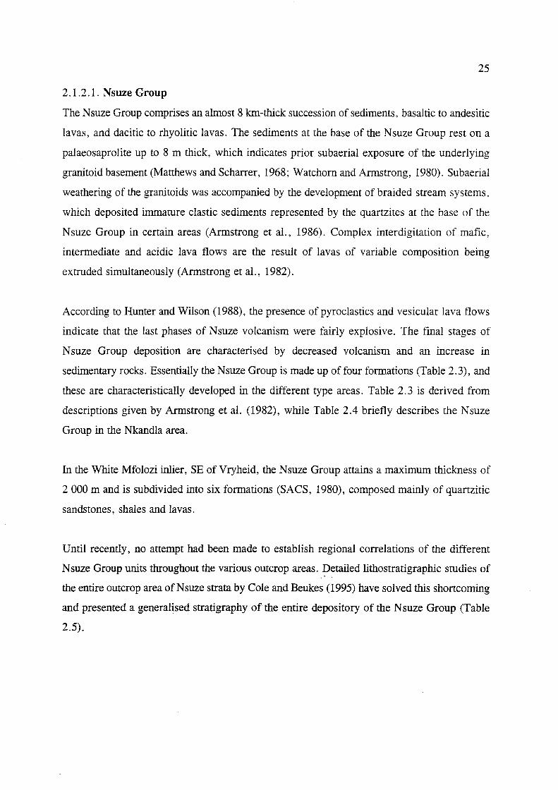
2.1.2.1. Nsuze Group
The Nsuze Group comprises an almost 8 lan-thick succession of sediments, basaltic to andesitic
lavas, and dacitic to rhyolitic lavas. The sediments at the base of the Nsuze Group rest on a
palaeosaprolite up to 8 m thick, which indicates prior subaerial exposure of the underlying
granitoid basement (Matthews and Scharrer, 1968; Watchorn and Armstrong, 1980). Subaerial
weathering of the granitoids was accompanied by the development of braided stream systems,
which deposited immature clastic sediments represented by the quartzites at the base of the
Nsuze Group in certain areas (Armstrong et aI., 1986). Complex interdigitation of mafic,
intermediate and acidic lava flows are the result of lavas of variable composition being
extruded simultaneously (Armstrong et aI., 1982).
According to Hunter and Wilson (1988), the presence of pyroclastics and vesicular lava flows
indicate that the last phases of Nsuze volcanism were fairly explosive. The final stages of
N suze Group deposition are characterised by decreased volcanism and an increase in
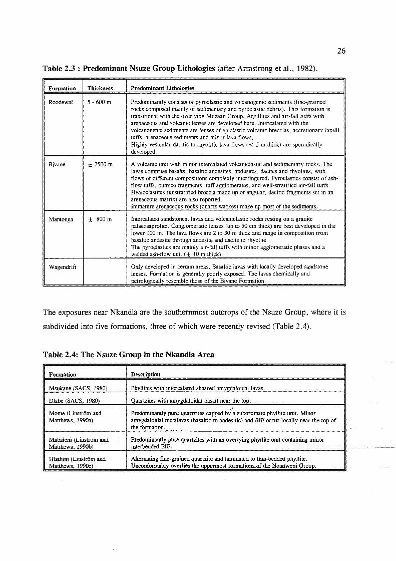
sedimentary rocks. Essentially the Nsuze Group is made up of four formations (Table 2.3), and
these are characteristically developed in the different type areas. Table 2.3 is derived from
descriptions given by Armstrong et al. (1982), while Table 2.4 briefly describes the Nsuze
Group in the Nkandla area.
In the White Mfolozi inlier, SE ofVryheid, the Nsuze Group attains a maximum thickness of
2000 m and is subdivided into six formations (SACS, 1980), composed mainly of quartzitic
sandstones, shales and lavas.
Until recently, no attempt had been made to establish regional correlations of the different
N suze Group units throughout the various outcrop areas. Detailed lithostratigraphic studies of -;- <
the entire outcrop area of Nsuze strata by Cole and Beukes (1995) have solved this shortcoming
and presented a generalised stratigraphy of the entire depository of the N suze Group (Table
2.5).
26
Table 2.3 : Predominant Nsuze Group Lithologies (after Armstrong et ai., 1982).
I Formation I Thickness I Predominant Litholog!es I Roodewal 5 - 600 m Predominantly consists of pyroclastic and volcanogenic sediments (fine-grained
rocks composed mainly of sedimentary and pyroclastic debris). This formation is transitional with the overlying Mozaan Group. Argillites and air-fall tuffs with arenaceous and volcanic lenses are developed here. Intercalated with the volcanogenic sediments are lenses of epiclastic volcanic breccias, accretionary lapilli tuffs, arenaceous sediments and minor lava flows. Highly vesicular dacitic to rhyolitic lava flows « 5 m thick) are sporadically developed.
Bivane ± 7500 m A volcanic unit with minor intercalated volcaniclastic and sedimentary rocks. The lavas comprise basalts, basaltic andesites, andesites, dacites and rhyolites, with flows of different compositions complexly interfingered. Pyroclastics consist of ash-flow tuffs, pumice fragments, tuff agglomerates. and well-stratified air-fall ruffs. Hyaloclastites (unstratified breccia made up of angular, dacitic fragments set in an arenaceous matrix) are also reported. Immature arenaceous rocks (quartz wackes) make up most of the sediments.
Mantonga ± 800m Intercalated sandstones, lavas and volcaniclastic rocks resting on a granite palaeosaprolite. Conglomeratic lenses (up to 50 cm thick) are best developed in the lower 100 m. The lava flows are 2 to 30 m thick and range in composition from basaltic andesite through andesite and dacite to rhyolite. The pyroclastics are mainly air-fall tuffs with minor agglomeratic phases and a welded ash-flow unit (± 10 m thick).
Wagendrift Only developed in certain areas. Basaltic lavas with locally developed sandstone lenses. Formation is generally poorly exposed. The lavas chemically and petrologically resemble those of the Bivane Formation.
The exposures near Nkandla are the southernmost outcrops of the Nsuze Group, where it is
subdivided into five formations, three of which were recently revised (Table 2.4).
Table 2.4: The Nsuze Group in the Nkandla Area
I Formation I Descri)2tion I Msukane (SACS, 1980) Phyllites with intercalated sheared amygdaloidal lavas. ~-~- --- - --
Dlabe (SACS, 1980) Quartzites with amygdaloidal basalt near the top.
Mome (Linstrom and Predominantly pure quartzites capped by a subordinate phyllite unit. Minor Matthews, 1990a) amygdaloidal metalavas (basaltic to andesitic) and BIF occur locally near the top of
the formation. ----- - ----- --
Mabaleni (Linstrom and Predominantly pure quartzites with an overlying phyllite unit containing minor Matthews, 1990b) interbedded BIF. --- - .------- ---- ---- -<.--
Hlathini (Linstrom and Alternating fme-grained quartzite and laminated to thin-bedded phyllite. Matthews, 1990c) Unconformably overlies the uppermost formations..ofthe NondweniGroup.

(f) c::: w I-w ::>: 0 oJ :;,:
II
10
9 -
8
7
6 -
5
4
3
2
I -
0
2 \TlYHEID·P!ET RET!!':F
ARE\
3
INSET
4 NKc\i'WL/\
ARE.-\
. .,r./"J Unconformi!y
! I.\DIAS
/ OCEA.'V I
j
II U5hu~hw<1n<1 Compl('~ o lron-rich sedirnen! 5 o Iwhere rhino indical('d b~ i1.J
11!llIIlil Argilli1ceous ndimen/s o Arenaceous sedimenrs
I: ::1 Volcanic rocl< 5
o Grani!o!-green5!One b<1Sl'men!
27
Fig. 2.8: Simplified stratigraphic columns of some inliers of the Pongola Supergroup (after Burke et a!. 1985).
Table 2.5: Regional Stratigraphy of the Nsuze Group (after Cole and Beukes. 1995)
I Formation I DescriEtion I Nzimini .. Highly deformed diamictite unit that is only preserved in the southernmost outcrops in
the vicinity of Nqutu.
Ekombe An upper lava unit that is only preserved in the Nkandla area...
Mkuzane A largely argillaceous unit that is best preserved inlhe northeastern outcrop areas~
VutshinilLangfollteill A predominantly arenaceou~ unit that is in some places characterised hy a hasal sedimentary/volcaniclastic unit termed the Roodewal Member. TIle Vutshini Formation outcrops in the Nkandla area and is a southern correlate._oLlheJ .. angfonteio. Formation.
Agatha A middle lava unit within which a shale-rich subunit (Ntambo Member) is developed in the northern outcrop area. To the south, the shale uniLbecomesquartzitic. - -_._-
White Mfolozi A middle-sedimentary unit predominantly composed of quartzite and shale with subordinate siltstone, diamictite and a characteristic stromatolitic carbonate marker bed (the Chobeni Member). ~----
-_. -
Pypklipberg A dominantly mafic, amygdaloidal lava unit.
Mantonga A basal sedimentary unit composetl primadly of quartzite. with sUOordinate shale. diamictite and conglomerate. -----, -- ~- -- ----------- .----. -- - - - -.. .. * : TIle NZlmlm Formallon has limited outcrop and structural compleXities which precludes the establishment of an exact
stratigraphic position.

28
2.1.2.2. Mozaan Group
The Mozaan Group rests with a broadly gradational contact (Watchorn, 1980a) over the Nsuze
Group and comprises mainly arenaceous and argillaceous sedimentary rocks. However, in the
White Mfolozi inlier, the Nsuze-Mozaan contact forms a marked unconformity, as a
progressive overstep has removed approximately 1 200 m of Nsuze Group stratigraphy (Gold,
1993). The lithologies are mainly mudstone, siltstone and sandstone, interlayered with
conglomerate, banded iron-formation (BIF) and recently-recognised Archaean diamictite (von
Brunn and Gold, 1993; Gold, 1993).
Two depositional environments for the Mozaan sediments are proposed (Beukes and
Cairncross, 1991). The first is a mainly current-, wave- or storm-dominated marine shelf
environment which formed shale-siltstone/quartzite successions, iron formation and magnetic
mudstone, which are interbedded with marine shelf environment laminated sediments. The
former depositional environment is interbedded with a fluvial braidplain environment that is
typified by very coarse-grained to pebbly sandstones and a virtual absence of mudstone.
Metamorphism is generally of lower greenschist facies except where the lithologies were
affected by effects of contact metamorphism due to granite and mafic-ultramafic intrusives
(Linstrom, 1987b).
A composite reference stratigraphic profile for the Mozaan Group from type areas in the
Bivane and Mozaan River gorges is detailed by Beukes and Cairncross (1991). The nine
subdivisions recognised are briefly described in Table 2.6. This profile is important in that it
shows many similarities with the Witwatersrand Supergroup (see chapter six). Stratigraphic
profiles of specific areas have been detailed by SACS (980), Gold (1993) and Gold and Von
Veh (1995).

29
Table 2.6: Subdivisions of the Mozaan Group (After Beukes and Cairncross, 1991).
I Formation I Thickness I Litholog!cal Descrietion I Ntanyana ± 150 m Finely-laminated shale at the base overlain by ferruginous. immature
_quartzites and siltstones.
Gabela ± 150 m Coarse-grained and agglomeratic at the base with green, massive. quartz-bearing volcaniclastic greywacke towards the top.
Bongaspoort ± 250m Coarse-grained, slightly argillaceous, khaki-coloured quartzite, siltstone and shale. Has sharp contact with the overlying Gabela Formation.
Khiphunyawa ± 510 m Mainly laminated ferruginous shales and magnetic mudstones. The 40 - 50 m thick Tobolsk mafic lava member occurs here and is highly amygdaloidal, with thin tuffaceous beds at the top and bottom. The lavas are overlain by shales, siltstones and quartzites.
Delfkom ±loo0m Consists predominantly of coarse-grained quartzites with interbedded shales and magnetic mudstones. Thin, lenticular chert-clast lag conglomerates also occur. Numerous mafic sills intrude the succession.
Hlashana ± 125 m Consists mainly of medium- to coarse-grained quartzites with well-developed sedimentary structures. Angular chert pebble lags are present at the base of some units.
Thalu ± nOm Basal ± 40 m thick quartzite overlain by a prominent 10 m-thick BIF (Scots Hill member). This is overlain by five units of shale-interlaminated shale/siltstone facies successions. The uppermost part of this formation is obscured by a 360 m thick mafic sill which is in direct contact with the quartzite if the Hlashane Formation.
Ntombe ± 1300 m Comprises successions (up to 200 m thick) of carbonaceous shale and interlaminated shale/siltstone, with some successions capped by quartzites. Iron-formation present in the upper part has irregular chert-mesobanding.
Sinqeni ± 580 m Consists of two major quartzite units (Dipka and Kwaaiman members) separated by an 80 m thick Ijzermijn shale member containing a distinct 5 m thick bed of jasper-banded iron-formation. The basal Dipka quartzite member (± 330 m thick) rests with a sharp contact on underlying Nsuze Group lithologies.
2.1.2.3. Pongola Supergroup Intrusives
Pongola Supergroup volcanism and sedimentation was followed by the emplacement of mafic
and ultramafic intrusions mainly into the stratigraphically lowest formations of the N suze
Group (Hunter and Wilson, 1988). This was followed' by renewed granitoid magmatism
between 2.7 and 2.5 Ga (Tankard et aI., 1982). The youngest intrusives are represented by
Karoo-aged dolerite dykes and sills.
The Ushushwana Intrusive Suite (Fig.2.5) predominantly comprises quartz gabbro, diorite and
granophyre (Hunter and Wilson, 1988) and outcrops in three different areas. The Suite has
been dated, using Sm-Ndlwhole rock isochron, at 2876 ± 30 Ma (Hegner et al., 1984). In

30
KwaZulu-Natal it occurs as a sill like body at the base of the Nsuze Group.
The Hlagothi Complex (Fig. 2.5), recognised in the southern inliers in the lowermost
formations of the N suze Group, was found to have many similarities with Archaean basaltic
komatiites (Groenewald, 1984). In several sills, the upper lithologies contain skeletal pyroxene
blades in a fine-grained groundmass that resemble the spinifex texture in extrusive komatiitic
basalts (Groenewald, 1984) which are found in the Barberton greenstones, and in the
underlying Nondweni remnant (Hunter and Wilson, 1988). The intrusion comprises several
differentiated sills, each consisting of successive layers of peridotite, pyroxenite, olivine
gabbronorite and gabbro (Hunter and Wilson, 1988). Marked variations in average
compositions of the various units were noted with the layering resulting from the successive
fractionation of olivine, clinopyroxene and orthopyroxene. From age determinations and field
relations Groenewald (1988) speculated that the intrusion occurred during the deposition of the
Pongola Supergroup, which would have several implications on the age suggested for the
complete stabilisation of the southeastern part of the craton. Other locally transgressive
ultramafic bodies also occur e.g. the Brandlaagte intrusive suite, which has been tentatively
correlated with the H1agothi Complex and the Ushushwana Complex (Versfeld, 1988).
A suite of post-Pongola granitoids were intruded mainly along the eastern and southern
margins of the Pongola Supergroup depositional basin. Matthews (1985) delineated three
distinctive granites along the eastern margin. In KwaZulu-Natal the extensive coarse-grained
Spekboom Granite and finer-grained Godlwayo granite were identified, each with a narrow (±
1 km) contact aureole. The granites have similar mineral assemblages, composed essentially
of quartz, K-feldspar and plagioclase with minor biotite and accessory sphene, apatite, zircon
and iron ore.
Due to locally developed accommodation structures (such as superimposed fold patterns) in the
adjacent Mozaan Group sediments, Matthews (1985) considered these plutons as anorogenic
intrusions and concluded from structural and stratigraphic evidence that these granite plutons
were emplaced at depths of approximately 6 to 7 kIn.

31
2.2. THE PROTEROZOIC: Natal Metamorphic Province
Thomas (1989a) recognised three discontinuity bounded tectonostratigraphic domains in the
Natal Metamorphic Province (Fig 2.9). These are (from north to south) the Tugela, Mzumbe
and Margate Terranes. These terranes were intruded by magmatic rocks of various ages. The
southern, western and eastern limits of the belt are concealed beneath younger cover rocks.
The Tugela Terrane boundary with the Archaean Kaapvaal Craton is known as the Natal Thrust
Front which has been previously described in this chapter, where the Tugela Terrane nappes
have been obducted onto the southeastern margin of the craton (Matthews, 1972).
The amphibolite- to greenschist-grade Tugela Terrane is separated from the upper amphibolite
grade Mzumbe Terrane by the Lilani-Matigulu Shear Zone (Jacobs et aI., 1993; Thomas et aI.,
1994b) while in the south, the Melville Thrust (Thomas, 1989a) separates the granulite-grade
Margate Terrane from the Mzumbe Terrane. The Lilani-'Matigulu shear zone also represents
the geophysical southern margin of the Kaapvaal Craton (Thomas et al., 1994b), which further
validates the obduction theory. The southern margin of the Margate terrane is not exposed.
Thomas and Mawson (1989) however, reported a return to amphibolite facies and a unique
pretectonic Sikombe Granite in the Eastern Cape Province, which may represent the remnants
of another tectonic domain lying to the south of the Margate Terrane. The Sikombe Granite
may be related to the Margate Granite Suite (Thomas, 1990d).
The rocks of the Tugela Terrane have been interpreted by Matthews (1972) as being an
ophiolite assemblage that was deposited in an oceanic basin to the south of the Kaapvaal
Craton. This terrane was then intruded by mafic-ultramafic complexes, alpine serpentinites,
plagiogranites and a number of alkaline to peralkaline gr~toids (e.g. Scogings, 1989a). The
oldest rocks recognised in the Mzumbe and Margate Terranes comprise arc-related, felsic to
mafic metavolcanic supracrustal gneisses with subordinate metasediments (Thomas et al.,
1992d). According to Thomas and Eglington (1990), volcanic~arcs associated with. the
subduction of the Tugela Ocean were responsible for the development of the two southern
terranes. The NMP has been regarded as a juvenile orogen, since no trace of older basement
or floor upon which the rocks may have been deposited is recognised (Thomas and Eglington,
1990).
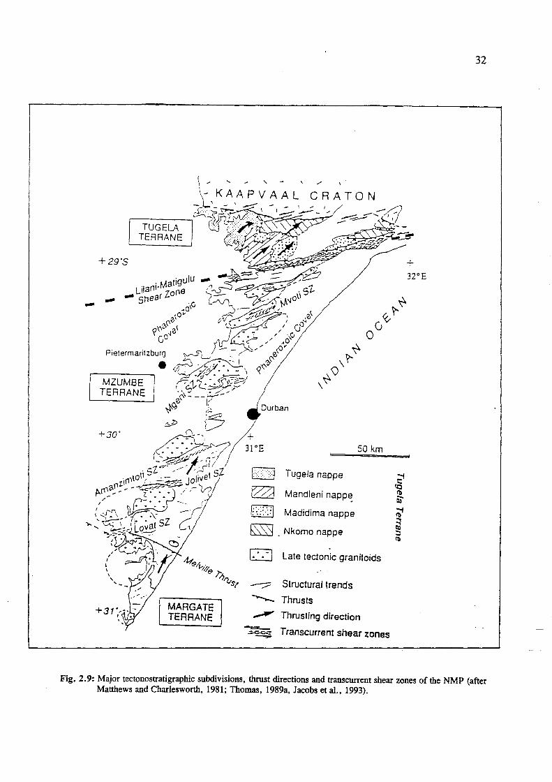
TUGELA TERRANE
+29'5
Pietermaritzburg
MZUMBE TERRANE
+30'
•
MARGATE TERRANE
Durban
Tugela nappe
Mandleni napp~
Madidima nappe
bSSj . Nkomo nappe
50 km
r;-:;, l.!.....!..J Late tedonic granitoids
Structural trends
--- Thrusts
~ Thrusting direction
~ Transcurrent shear zones
32
Fig. 2.9: Major tectonostratigraphic subdivisions, thrust directions and transcurrent shear zones of the NMP (after Matthews and Charlesworth, 1981; Thomas, 1989a, Jacobs et aI., 1993).

33
The following account, from Thomas et al. (1994b, 1995b), briefly describes the sequence of
events that occurred in the NMP. During an early phase of NE-directed thrusting and nappe
emplacement, which resulted from oblique arc-continent collision associated with the closure
of the Tugela Ocean, the three NMP Terranes were accreted onto the SE margin of the
Kaapvaal Craton. This led to an inverse metamorphic stacking across the belt, such that the
southern granulite Margate Terrane was thrust over the upper amphibolite Mzumbe Terrane
(Fig.2. 10). The Mzumbe Terrane was thrust over the amphibolite/greenschist facies Tugela
Terrane, which was in turn thrust onto the craton to the north (Thomas et al., 1994b).
From thermobarometric studies in southern KwaZulu-Natal, it has been noted in Thomas et
al. (1992a), that while the peak metamorphic temperatures of the two sout11ern terranes are
different (Margate Terrane > 800°C and Mzumbe Terrane < 750°), pressures were generally
similar throughout at between 5-8 kb. This led Thomas et al. (1992g) to suggest that the
southern granulite terrane does not represent a deeper portion of the crust than the northern
amphibolite terrane and the higher temperatures were probably attained due to more extensive
magmatic underplating.
SOUTH NORTH I I
MZUMBE TERRANE ____ --------1- TUGEL4 -_1_- CRATON--I TERRANE I TERRANE
D·· .. ... Late tectonic granitOids of the Oribi Gorge Suite
Margate Terrane
Mzumbe Terrane
I?HiKI. Tugela Terrane
'-
Archaean Kaapvaal Craton
/" Thrust
~I Shear Zone (0 Into paper; • out of paper) 1:1
MT = Melville Thrust
JS = Jo/ivet Shear Zone
AMS = Amanzimtoti Shear Zone
LMS = Lilani-Matigulu Shear Zone
MGS = Mgeni Shear Zone
MVS = Mvoti Shear Zone
Fig.2.10: Schematic cross-section of the Natal Metamorphic Province (after Thomas et aI., 1994b).

34
The initial phase of NE-directed thrusting led to crustal thickening, which progressed to ductile
transcurrent shearing with continued thrusting. This collision-induced crustal thickening caused
intense deformation, while high-grade metamorphism led to widespread melting and the
generation of vast granitoid magmas that intruded the southern terranes (Figs. 2 .11A ,B, C).
These early (- 1.3 Ga) gneisses were intruded at - 1.2 Ga by calc-alkaline, I-type granitoid
orthogneisses, probably in a mature volcanic-arc setting (Thomas and Eglington, 1990) and by
syn-, late- and post-tectonic granitoids between - 1.1 and 1.0 Ga (Eglington et aI., 1989;
Thomas et aI., 1990b, 1992d,e). The syn-tectonic magmatic events produced intrusions of
sheet-like granitic gneisses, of which many are peraluminous, S-type granites derived from
partial melting of the supracrustal sequences (Thomas et al., 1994b). Late-tectonic magmatism
was ascribed by Thomas (1988a) to be represented by voluminous rapakivi-textured
granitoid/charnockite plutons of the Oribi Gorge Suite. Post-tectonic magmatic activity is
considered to be represented by a small swarm of micro granite dykes in the Margate area
(Thomas et aI., 1990b).
Continued NE-directed thrusting onto the Kaapvaal Craton (which can be regarded as a SW
directed indentor) resulted in pervasive left-lateral transcurrent shearing in Natal (Fig.2.9). As
a result, the Mzumbe and Margate Terranes are extensively deformed by numerous SE- to
SSE-trending sinistral transcurrent shear zones and mylonite belts (Figs. 2.9 and 2.11 C). As
noted earlier, the Lilani-Matigulu Shear Zone coincides with the geophysically-determined
southern margin of the Kaapvaal Craton. This oblique wrench structure is thought to represent
a reactivation of a major long-lived transform margin (Matthews, 1990) which initially
separated the Kaapvaal Craton from the Tugela Ocean. The 1'ugela-Terrane thrust nappes
overlie the rigid cratonic crust and were not affected by later shearing. It is likely that large
amounts of this strain were accommodated along the old transfonn margin, resulting in the
formation of the Lilani-Matigulu Shear Zone (Thomas et aI., 1995b).
The tectonic evolution and mineralisation in the Natal Metamorphic Province will be discussed
in detail in Chapter Six.
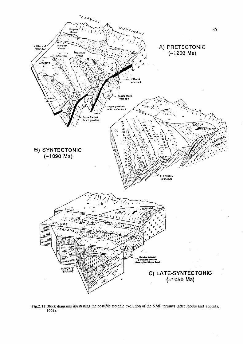
8) SYNTECTONIC (-1090 Ma)
, J.ryp. O'~nllowjl of "humbe sull.
A) PRETECTONIC (-1200 Ma)
f}'.:JnlIOI(jS
C) LATE-SYNTECTONIC (-1050 Ma)
35
Fig.2.11:Block diagrams illustrating the possible tectonic evolution of the NMP terranes (after Jacobs and Thomas. 1994).

36
2.2.1. The Tugela Terrane
This northern terrane comprises the intensely folded and imbricate Natal Thrust Front
(maximum 12 kIn wide) and a nappe zone (Fig.2.12). The northernmost part of the terrane is
in tectonic contact with rocks of the Kaapvaal Craton. Matthews (1972) suggested that the
thrust front represents a deformed and metamorphosed Proterozoic obduction zone, consisting
of mafic/ultramafic oceanic crust overlain by pelagic metasediments and metalavas which were
interpreted as the middle and upper pans of an ophiolite complex. These rocks were
transported northwards in a series of thrust nappes onto the SE margin of the Kaapvaal Craton
along a sole decollement known as the Mfongosi Thrust (Matthews and Charlesworth, 1981).
The southern extremity of the Tugela Terrane is represented by the Matigulu Steep Belt.
The Tugela Terrane has been subdivided by Linstrom (1987a) into four groups, based on data
derived from Matthews (1959, 1981a), Matthews and Charlesworth (1981) and (SACS, 1980).
The Ntingwe and Mfongosi Groups have been recognised in the thrust front. To the south, the
four thrust nappes have been collectively placed into the Tugela Group, while the Matigulu
Group represents the steep belt. The various formations that make up these groups in the
different areas are summarised in the tables below. All lithologies are in descending order. For
outcrops of the individual formations, the reader is referred to the 1 :250 000 scale Geological
Survey Map of Dundee.
2.2.1.1. Natal Thrust Front: Ntingwe Group and Mfongosi Group
According to Matthews (1959) and Cain (1975), the Ntingwe Group lithologies represent stable
shallow water shelf sediments, while the Mfongosi Group comprises a "mixed vo1canic
tuffaceous-flyschoid-argillite sequence". The Ntingwe Group unconformably overlies the older - ~ -,
granites and supracrustal sequences of the Kaapvaal Craton. It is overlain by the Mfongosi
Group which had been thrust onto it.
The Mfongosi Group occurs in two sectors along the frontal part of the thrust belt, with four
formations delineated in each of the eastern and western sectors (Fig.2.12). Predominant
lithologies are greenschist facies chlorite-rich metalavas (with pervasive carbonate alteration)

37
and phyllitic/schistose meta-pelites, with locally developed, thin, laterally persistent graphitic
schist horizons (Thomas et al., 1990a).
Table 2.7 : Ntingwe Group Lithologies
I Formation I Thickness I Lithology I Makasana ± 90m White limestone with a few thin argillite beds and a sandy, ferruginous
dolomitic limestone with a number of thin interbedded mudstones.
Manzawayo ± 170 m Alternating beds of blue mudstone and grit overlain by massive to coarsely bedded mudstone and shale with impressions of carbonaceous material. Minor intercalated red and white limestones also present.
Dlolwana ± 100 m Coarse clastics ranging from arkosic grit to conglomerate and breccia containing fragments of foreland lithologies up to 30 cm in diameter.
.. Data from Matthews (1959), SACS (1980) and Lmstrom (1987a) .
Table 2.8a : Mfongosi Group - Western Sector (after Linstrom, 1987a)
I Formation I Predominant Lithology I Matigwe Schist Phyllitic schist and contorted quartz-muscovite (chlorite) schists containing abundant quartz
segregation veins.
Ngubevu Schist Metamorphosed amygdales and deformed pillow lavas. Chlorite-epidote schist with some talc, carbonate and albite, and fine-grained amphibolite. A ± 6 m thick BIF occurs interbedded within the schist and amphibolite.
Dinuntuli Schist Laminated quartz-chlorite-sericite schist with intercalations of quartz-carbonate-chlorite schists (which are often altered to calc-silicates). Thin units of fine-grained quartzite (pebbly in places) are locally developed.
Samangu Schist Foliated and massive amphibolite with relict amygdaloidal and deformed pillow structures. Undifferentiated, banded pyroxene- or biotite-bearing hornblendegneiss.
Table 2.8b : Mfongosi Group - Eastern Sector (after Linstrom, 1987a)
I Formation I Predominant Litholo~ ----~ . I
Sibudeni Schist Quartz-chlorite-sericite schist with subordinate sandy phyllite, quartzite and BIF. Also present are chlorite-amp_hibole schist, siliceous chlorite mylonite and garnet-chlorite-quartz schist.
B~Schist Fine- to medium-grained, crenulated quartz-sericite schist which is chlorite rich in places. _
Nkunzana Schist Well-foliated, quartz-chlorite phyllitic schist with minor biotite and sericite; Siliceous mylonite also occurs. - --------"---- --" --
Mazula Schist Succession of fme-grained biotite-muscovite-quartz schist with porphyroblasts of red garnet and brown staurolite. Discontinuous granular quartz lenses and veins concordant with the schistosity also noted.

~ .. --.~ /.'
~,~;w~~~0iJ ugeJa Terrane "~~;.:\ y'
""' ... MAMULIJ ...... t1tIO"'.-- ... ;.;.;.y '" ,}Jo.":
M./P'. '" .::~7 c.:ii'<"
1) ~~. /
~ , ~'"."''''"'J.O . r/*.' .' Cl' ,. i . v. L OUPI'I."'''
1)
E ~ ~
/~ ~.~
-"",'iT .
,~ '-~"' .... ::'1
" '"1':' .. ~ i!/ t"'\.L"H"I,/'T-~~ '~ '.;/"l' l~
1'Pate Terrane (:)~' \ ., M
'~!f~ (/
"~
_ ~~Q~.·D:O'C ........
'U.1 .... • ·O'.".C(
.....--, _".- '0 .,..I_tn' ..... ·• :............. ·CDO"",", "." ...
C· ........ · .......... C o "' ... ~~,. '0"'"0"'.
D·,,· .. ·,·",·. ' ~ >.J.PvA)..l. P""=""i'4C(
l.:.-..:.' c,."n".-"...._"_ I ..........
/101 ...... ' ........ ,1_.
" 0 ~('
KranskopCll
o 10 ]0 ~,,,
...... ===-----===J
Tt,e 10C8t,on of the lugela lerrane with,n the NMP
Phanerozoic Cover/Basement
Melll10th Cll
0Eshowe
q <l
Natal Thrust Front
Tugela Nappe
Mandleni Nappe
Madidima Nappe
Nkomo Nappe
Steep Thrust Belt
Ultramafic Intrusives
Kotongweni Tonalite
Metagabbro
Thrust Faults
31°45'
Fig 1,12: Simplilkd t~j(lnic nmp sh(lwing subdivisions of the Tu~cla TcrrHnc (aller Matthews amI C'harkswonh, lQRl),
w z ~ a: w I-
:3 w (!) ::J I-
28°48' ,

39
Nappe Zone: Tugela Group
The Tugela Group is present in the four sub-horizontal thrust sheets which comprise the
Nkomo, Madidima, Mandleni and Tugela Nappes (Linstrom, 1987a) , with each nappe or
thrust sheet divided into a number of formations in either the eastern or western sector of the
Tugela Terrane (Fig.2.12). These are tabulated below, from the lowest thrust sheet upward
with brief descriptions of each formation from SACS (1980) and Linstrom (1987a). The
intrusives in each nappe will also be described.
2.2.1.2.1. Nkomo Nappe
This lowermost thrust sheet, which occurs in both the eastern and western sectors of the Tugela
Terrane, was mapped in detail by Charlesworth (1981, cited in Linstrom, 1987a) and consists
mainly of amphibolite and granitoid gneiss.
Table 2.9: Nkomo Nappe: Formations and Lithologies (after Linstrom, 1987a)
Western Sector
Khomo Formation Foliated, fine- to medium-grained, melanocratic amphibolite with dominant hornblende Woshane Formation and plagioclase. Subordinate biotite and chlorite also present.
Eastern Sector
Mtengu Formation Similar to the Khomo and Woshane Formations above
2.2.1.2.1.1. Nkomo Nappe Intrusives
Hlobane Complex
The HIobane Complex, in the eastern sector, consists of weakly foliated to massive, medium
to coarse-grained meta-igneous rocks. According to Linstrom (1987a), the rocks grade in
composition from olivine norite through troctolite gabbro to normal gabbro. Thin anorthosite
and serpentinite bands also occur.
Bulls Run Complex (BRC)
This Complex (Fig. 2.13) forms a prominent easterly trending ridge, some 15 km long and up
to 1,5 Ian wide, above the north bank of the-Mhlatuze River. The BRC is lithologically
complex and comprises a variety of geochemically related undersaturated to saturated
alkaline/peralkaline syenitic gneisses and minor dyke- or sheet-like intrusive phases of

40
peralkaline microsyenite dykes, alkaline mafic gneiss and carbonate gneisses (Scogings. 1989b,
1991 a). The carbonate gneisses were interpreted as metamorphosed carbonatites by Scogings
and Forster. (1989).
Three syenite gneisses have been recognised here. namely nepheline syenite, albite syenite and
muscovite syenite. The nepheline and albite syenites form the elongate central core of the
complex. The nepheline syenites in the eastern part of the complex are pyroxene-bearing mafic
varieties while in the central and western parts, the syenites are biotite-rich and are leucocratic.
The albite syenites are leucocratic and relatively siliceous. The muscovite syenites form an
envelope around the nepheline and albite syenites and are characterised by high muscovite
contents. Several small plug-like occurrences of nepheline syenite gneiss also occur towards
the eastern end of the complex. Detailed mineralogical and geochemical analyses on this
Complex were carried out by Scogings (1989b) and Scogings and Forster (1989).
31'18'
:lor >( lr ~ '" -": 10,. ~ , ;~ ~ ._____Natal Thrust Fronl It-"" ".. -'" >.- _'\ ,-,\ .... ..r'
.)( A .J.. x #'\ )0;. ~ ~ >( >r"." -"t" -'"
Ngoye Complelf
. ; ...
Tugefa Terrane : Eshowe Ij)
.. - .,.
..... ~ . . . .. I~"·'·'·'·"I / .. : .: . : . : .: . : .
km 10
I
l ·.·.·.;...:.. ~M.p •• - 1\ ~.,.,., .-6- a' se Aff93
.qua- Hat Durban
Clip. Town---~
o Il90km
Fig 2.13: Distribution of tJle Bulls Run Complex. Wnngu Gneisses, Ngoye Complex and lIalambu Fonnation gnei!lses within the Tugela Terrane (from Scoging!l. 1989a; 199Ib).

41
Ngoye Complex
The Ngoye Hills SW of Empangeni (Fig.2.13), in the eastern sector of the Tugela terrane,
consists mainly of rocks of the Ngoye Complex (Scogings, 1990). The intrusion forms a
prominent easterly-trending whaleback massif about 30 km long and up to 4 km wide, with a
height of 300 m above the country rocks. A smaller satellite body, about 3 km long occurs NE
of the main intrusion.
The Complex essentially consists of geochemically related alkaline to peralkaline A-type
granitoid gneisses and minor mOIlZodioritic and syenitic gneiss phases (Scogings, 1985; 1986;
1990). The lithologies have been subdivided according to geochemistry and mineralogy into
three broad varieties of granite gneisses, namely peraluminous, peralkaline and metaluminous
types. The peraluminous granites are muscovite- and garnet-bearing while the metaluminous
varieties contain pale-green biotite and hornblende. The peralkaline variety consists of
riebeckite granite gneiss and magnetite micro granite gneiss, with fluorite and zircon as
common accessory phases.
Halambu Granitoid Gneiss
These deformed intrusive gneisses of calc-alkaline, granodioritic affInity outcrop in both the
eastern and western sectors of the Nkomo Nappe. The rocks show a strong pervasive east-west
foliation and were metamorphosed to upper amphibolite grades. Charlesworth (1981) was first
to give a detailed description of these intrusive rocks, which were further differentiated by
Scogings (1989a).
Wangu Granite Gneiss
These alkaline/peralkaline granitoid gneisses with minor alkaline mafic intrusive phases have
recently been differentiated within the granodioritic gneisses of the-Halambu Formation in the
western sector of the NMP (Scogings, 1989a; 1991b). The intrusion is an elongate easterly
trending body some 6 km long and up to 1 km wide (Fig. 2.13). Two granitic gneisses and one
mafic gneiss have been recognised on the basis of modal mineralogy (Scogings, 1991 b).
Leucocratic magnetite granite gneiss predominates, with biotite and fluorite as accessory
phases, while aegerine granite gneiss forms the other granitic phase. The mafic gneiss occurs
as sheets up to 30 m long and 1 m thick, and contains xenoliths of peralkaline granitoid gneiss

42
(Scogings, 1991b).
2.2.1.2.2. Madidima Nappe
This nappe occurs in the eastern and western sectors and comprises six formations as shown
in Table 2.10.
Table 2.10 : Madidima Nappe Formations and Lithologies (after Linstrom, 1987a).
Western Sector
Silambo Formation Banded and homogeneous amphibolite formations which comprise a variety of mineral Zwaneni Formation assemblages but with dominant hornblende and plagioclase and local concentrations of garnet
or epidote. Dolomite, quartzite and magnetite quartzite are associated with the homogeneous amphibolite in places.
Zidoni Formation Streaky and banded amphibolitic gneiss containing plagioclase. hornblende and biotite.
Gazeni Formation Well-foliated micaceous schist and gneiss containing biotite, muscovite, quartz, plagioclase, garnet and staurolite.
Thawini Formation Light-grey, well-foliated gneiss made up of plagioclase, quartz and biotite, ± hornblende, with minor epidote, gamet, magnetite, sillimanite, staurolite and cordierite.
Eastern Sector
Endlovini Formation Essentially similar lithologies to the Silambo and Zwaneni Formations above.
2.2.1.2.2.1. Madidima Nappe Intrusives
The Zwaneni and Silambo Formations are intruded by small bodies of serpentinite.
Mlalazi Complex
This Complex, confined to the eastern sector (Fig. 2.12), comprises a thrust-bound serpentinite
body, an ultramafic schist unit, and a metagabbro (Linstrom, 1987a). The serpentinite body
is well-foliated and contains minor amounts of metapyroxenite, with thin layers of talc schist
along some of the thrust boundaries. The fme- to mediuIh'::grainedl:lltrainafic schist contains ~
variable amounts of talc, amphibole and chlorite, while the leucocratic to melanocratic gabbro
(also fme- to medium-grained) contains numerous~-amphibolite inclusions.
2.2.1.2.3. Mandleni Nappe
The Mandleni Nappe, confined to the western sector, consists of four formations (Table. 2.11)
and two intrusive mafic and ultramafic bodies.

Table 2.11: Mandleni Nappe Formations and Lithologies (after Linstrom, 1987a).
I Formation I Predominant Litholo~es Wosi Well foliated, dark grey to greenish black amphibolite with> 50% hornblende and white
feldspar specks which form streaked-out lenses parallel to the foliation. Fine- to medium-grained quartzite and magnetite-bearing quartzite occur as narrow bands or lenses.
Tondweni Dark-coloured hornblende-plagioclase gneiss (with or without diopside and quartz) characterised by Jlfominent folded migmatitic banding.
Dulumbe Primarily a metapelite, comprising quartz-biotite gneiss and quartz-sillimanite-garnet-biotite gneiss. Porphyroblastic garnet. concentrated in bands and lenses is very common.
Dondwana Intense folding and prominent migmatitic banding characterise these grey biotite-feldspar gneiss and hornblende-biotite gneiss. Main minerals are quartz, plagioclase and biotite with subordinate hornblende. Locally developed small lenses of garnetiferous gneiss also occur.
2.2.1.2.3.1. Mandleni Nappe Intrusives
Sithilo Complex
43
I
The Sithilo Complex is one of a number of east-west trending ultramafic bodies that occur in
the area (Fig.2.12). It is approximately 3 km long and varies in width from 0.5 to 1 km. The
bulk of the Sithilo body is composed of serpentinised dunite and olivine peridotite in which
primary cumulate textures are locally developed. Harzburgite and pyroxenite are usually
developed around the outer rim of the body. Dunite is host to the economically exploited
chromite mineralisation at Sithilo. The Sithilo Complex is intruded by several late-stage aplite
dykes, along whose sheared contacts are developed cross-fibre chrysotile asbestos. According
to Wuth and Archer (1986), the lithology, structure and tectonic setting of the body indicate
that the Sithilo Complex is a Precambrian equivalent of younger, alpine-type ophiolitic
chromite deposits found in other parts of the world.
Mambula Complex
The Mambula layered mafic complex outcrops over an _~rea of 25 km2 about 20 kIn east of
Kranskop, near the confluence of the Tugela and Mambula Rivers (Fig.2.12). The Complex,
which intrudes the Dondwana, Tondweni and Wosi Formations (Linstrom, 1987a), consists
largely of medium-grained gabbro with subordinate norite, websterite, and vanadium-bearing
titaniferous magnetite layers, and is intruded by coarse-grained to pegmatitic diallagite and
anorthosite dykes and sills (Schulze-Hulbe, 1979). A broad saucer or funnel-like shape is
envisaged for the body due to the radially dipping contacts of the layering.

44
Reynolds (1986) concluded that the Mambula Complex formed by the fractional crystallisation
of a mafic magma, with the ores forming during the later stages of the crystallisation sequence.
He also states that the more felsic and Fe-rich nature of the Complex suggests that it represents
the higher part of a layered complex than the nearby Tugela Rand Layered Suite (TRLS). Like
the TRLS, the Mambula Complex was also affected by deformation and metamorphism during
the development of the NMP, where it was subject to amphibolite facies metamorphism (which
modified the texture of the Fe-Ti oxide ores) and northward directed thrusting.
2.2.1.2.4. Tugela Nappe
This tectonic unit is made up of two formations (Table.2 .12) and a number of intrusive bodies
such as an ultramafic complex, tonalites, sheets of metagabbro, diorite and granite.
Table 2.12: Tugela Nappe Fonnations and Lithologies (after Linstrom, 1987a).
I Formation I Predominant Litholog!es
Manyane Interfolded medium-grained, streaky, veined or massive amphibolite. Predominant minerals are hornblende (50%), plagioclase and quartz.
Tuma Interlayered sequence of metapelitic schist and gneiss, metapsammitic schist and gneiss and metavolcanic schist and gneiss, with rare graphitic schists also occurring. The metavolcanic unit consists of amphibolite and chlorite-actinolite schist. The amphibolite often displays deformed pillow structures composed of a fine-grained aggregate of epidote, hornblende and actinolite with subordinate chlorite. In zones of intense shearing the amphibolite has been altered to chlorite-actinolite schist due to retrograde metamorghism.
2.2.1.2.4.1. Tugela Nappe Intrusives
Tugela Rand Layered Suite (TRLS)
I
The TRLS (Wilson, 1990) is located 10 km north of Kranskop (Figs. 2.12 and 2.14) and
consists of a well-layered association of mafic and ultramafic rocks which crop out over some
64 km2• Predominant rock-types include wehrlite, gabbronorite, clinopyroxenite, bronzitite,
lherzolite and serpentinite, with minor troctolite, websterite, harzburgite and chromitite
(Wilson, 1990). According to Wilson, th~TRLS formed as a result of repeated, and-sometimes
continuous, emplacement of magma into a chamber which at the same time was undergoing
crystallisation, while subsequent deformation altered the original sheet-like form of the
intrusion. Many primary magmatic structures such as fme-scale layering, erosion and
truncation of layers, slumping and modally graded layers are preserved.
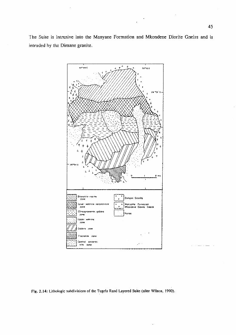
45
The Suite is intrusive into the Manyane Formation and Mkondene Diorite Gneiss and is
intruded hy the Dimane granite.
Bronll"'e! -nOrlte lonl!'
l.o~r wehrllt!- ~l!'rOl!'n"nltf!
zone
Clinopyroxenllf!. qobbro zont!
UDoer wehrl,f@ lon,
Gabbro lont!
Trocto'''e lone
Cenfrol serpentl· nrte lone
o Oimon~ G,onll!
~ Monyomf! Formation ~ Mkondone Otoro'! Gne,ss
Dllo,oO
Fig. 2.14: Lithologic ~ubdivisions of lite Tugela Rand Layered Suite (after Wilson. 1990).

46
Mkondeni Diorite Gneiss
This unit consists of numerous medium-grained mesocratic, biotite-bearing dioritic rocks with
minor hypersthene which locally grades into a medium-grained biotite-hornblende gneiss.
Injection migmatite with flow folds is common, and usually developed along the Manyane
Formation - diorite contact.
Kotongweni Tonalite
This coarse-grained tonalite body (in the western sector) (Fig. 2.12) contains up to 30%
hornblende, with minor amounts of red-brown garnet. Narrow sheets and irregular lenses of
pegmatite occur within the tonalite, which also contains rafts (10 to 50 cm in length) of
amphibolite.
Dimane Granite
These medium- to coarse-grained, pink to orangish granites with minor biotite intrude the
Mkondeni Diorite and the TRLS. Increasing biotite contents accentuate the westerly dipping
foliation. Fine-grained, leucocratic, aplitic sheets, possibly related to this granite, are intrusive
into Manyane Formation amphibolites and other Tugela Nappe intrusives.
Sheets of Metagabbro
These coarse-grained, unfoliated hornblendites which grade into plagioclase amphibolite are
intrusive into the Manyane Formation. Relict pyroxene and igneous textures were observed in
thin section (Linstrom, 1987a) and the rocks can be termed metapyroxenite, metagabbro or
anorthositic metagabbro.
Macala Complex
This meta-igneous complex is also intrusive into the Manyane Formation. It comprises mainly
gabbroic rocks with minor serpentinite and thin bands of titaniferous magnetite.
2.2.1.3. Matigulu Group
The Matigulu Group represents the steep thrust belt which marks the southern limit of the
Tugela Terrane (Fig. 2.12). This Group comprises four formations (Table 2.13) and is intruded
by the Buhleni Granitoid-Gneiss.

47
Table 2.13 : Matigulu Group Formations and lithologies (after Linstrom, 1987a).
I Formation I Predominant Litholo~es I Mpisi Occurs in the western part of the steep belt and consists of biotite-feldspar gneiss with minor
hornblende. The rocks are strongly foliated with intense folding.
Sequembi Also in the western part of the steep belt. Consists predominantly of well foliated. dark-green to black amphibolite with hornblende predominant and minor diopside and/or epidote. Thin bands and lenses of magnetite quartzite and dolomitic limestone occur at various levels throughout the formation. Agmatite (made up of banded and streaky amphibolite breccia and rafts) are common within the amphibolites.
Intuzi Occurs in the eastern regions. Fine-grained. grey, highly deformed, finely banded and streaky biotite-rich gneiss with a number of infolded, thin. impersistent quartz-feldspar veins and sheets.
Thondo Occurs in the SE part of the thrust belt. Composed of banded biotite-bearing amphibolitic gneiss. Locally grades into the Intuzi gneisses.
2.2.1.3.1. Matigulu Group Intrusives
The Buhleni Granitoid-Gneiss intrudes the Thondo and Intuze Formations in the central and
eastern parts of the steep belt. The intrusion is made up of banded quartz-feldspar gneiss,
biotite-granite gneiss, flaser gneiss and mylonite. Bands and lenses of amphibolite also occur,
along with bands of pegmatite.

48
2.2.2. The Southern Terranes
Previous literature (Thomas, 1988b; SACS, 1980) collectively placed the rocks of the NMP
south of the Tugela Terrane into the Mapumulo Group. However, subsequent detailed
investigations by Thomas (l989a) revealed several distinctions in the southern part of the
NMP. It was found that certain formations of the supracrustal gneisses all previously included
in the Mapumulo Group are confmed to either the northern or southern parts of the Province.
The gneisses to the north and south of Melville could not be correlated. Also, Thomas (l988c)
noted that the northern terrane was of amphibolite grade compared to a granulite-grade terrane
further south.
Other factors noted were the distinctive character of the pre- and syntectonic plutonic rocks
within these regions to the north and south of the Melville Shear, a major structural
discontinuity that was found to separate the two regions. However, the late-tectonic granitoids,
such as the Oribi Gorge Suite, are found to outcrop throughout (Thomas, 1988a). Thomas
(1989a) thus suggested that these northern and southern parts represent exposed fragments of
two distinct tectonostratigraphic terranes and the earlier nomenclature was revised. It was then
proposed in Thomas (1989a) that these two tectonic blocks be referred to as the Mzumbe
Terrane (in the north) and the Margate Terrane (in the south), separated by the Melville Shear
Zone (Figs. 2.9 and 2.10). Furthermore, the older gneisses in the two terranes recognised
above are lithologically distinct, and are placed within the Mapumulo Group in the Mzurnbe
Terrane, and those within the Margate Terrane are placed within the Mzirnkulu Group.
2.2.2.1. The Mzumbe Terrane: Mapumulo Group
Two formations (the Quha and Mpambanyoni Formations) of banded paragneisses and
migmatites, and a fine-grained, leucocratic pink acid gneiss sequence were initially recognised - ~ -.
within the Mapurnulo Group by Thomas (1989a). However, subsequent work by Thomas et
aI.(I99Ie) found that the original subdivision was not justified, and the Quha Formation now
includes the Mpambanyoni Formation.
The pink gneisses are typical of the Mzurnbe Terrane but have not been given formation status
yet as they are thought to be representative of diverse protoliths (Thomas, I989a). However
Thomas et aI., (l99Id) differentiated some of the pink gneisses of the Mapurnulo Group in the

49
southern part of the Mzumbe Terrane into the Ndonyane Fonnation on the basis of field
evidence (Fig. 2.15). Similar lithologies to the Quha and Ndonyane Fonnations have been
reported from undifferentiated rocks of the Mapumulo Group in the northern part of the
Mzumbe Terrane in the Lilani Area, though no fonnal correlation has been made (Thomas,
1992a).
Much evidence regarding the origin of these rock types is lacking, as primary textures have
largely been destroyed by polyphase defonnation, metamorphism and migmatization. Thomas
(1989a) regarded some of the highly siliceous rocks (up to 80% quartz + accessory magnetite)
to represent metamorphosed quartzitic sediments, while less siliceous gneisses with flattened
mafic inclusions were considered to be defonned granites. Fine-grained sillimanite and
tounnaline-bearing pink gneisses were thought to have originated from volcanic/volcaniclastic
rocks. The predominant lithologies are outlined in Table 2.14 and detailed petrographic
descriptions and localities are given in Thomas (1988b).
Table 2.14: Mapumulo Group Fonnations and Lithologies
I Formation I Predominant Litholog!es I Pink Acid Gneiss Varies from quartz-feldspar gneiss and migmatite to very fine-grained pink, streaky gneiss (Thomas, 1989a) and saccharoidal quartzitic gneiss. Also contains rare mafic pods and white quartzites.
Ndonyane Pink and/or grey, fine- to medium-grained, heterogeneous leucogneisses/migmatites. (Thomas et al., Restricted to southern part of the Mzumbe Terrane and may be correlated with the pink 1991d) gneisses above.
Quha (Thomas et Grey biotite quartz-feldspar gneiss; layered pelitic and semi-pelitic paragneisses, migmatites, aI., 1991e; schists and psammitic gneisses; amphibolites, hornblende gneisses and cummingtonite 1992d) amphibolites; and minor quartzites, calc-silicates and marbles.
Interpretations of protoliths of the individual rock units n:, the Quha Fonnation are detailed in
Thomas et al., (l992d). It was found that the gneisses represent a supracrustal package,
derived from rocks of volcanic/volcaniclastic origin ranging from intennediate ~(andesiticl to
mafic (basaltic) composition. Bands of thinly layered pyrite-garnet (Mn-rich)-quartz rocks are
also present, which are thought to have fonned in a hydrothennal, subaqueous volcanogenic
environment (Thomas et al., 1992d).
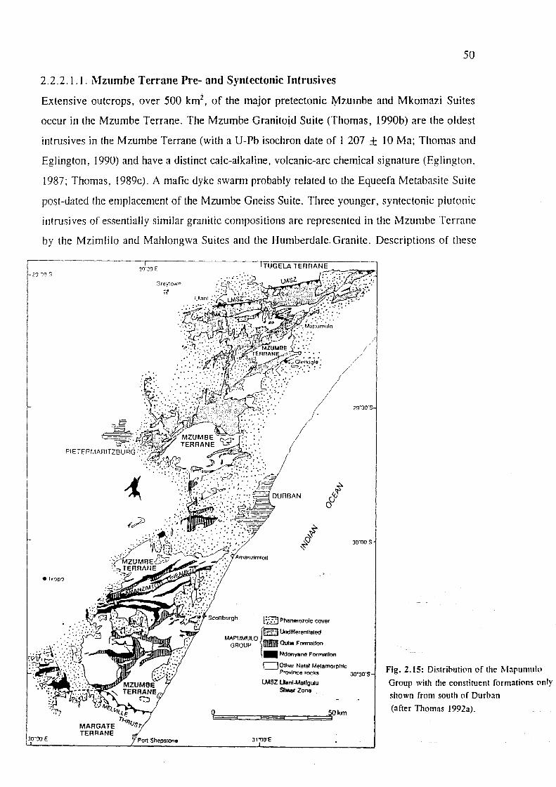
I
~
50
2.2.2.1.1. Mzumbe Terrane Pre- and Syntectonic Intrusives
Extensive outcrops, over 500 km2, of the major pretectonic Mzumbe and Mkomazi Suites
occur in the Mzumbe Terrane. The Mzumbe Granitoid Suite (Thomas, 1990b) are the oldest
intrusives in the Mzumbe Terrane (with a U-Pb isochron date of I 207 ± 10 Ma; Thomas and
Eglington, 1990) and have a distinct calc-alkaline, volcanic-arc chemical signature (Eglington.
1987; Thomas, 1989c). A mafic dyke swann probably related to the Equeefa Metabasite Suite
post-dated the emplacement of the Mzumbe Gneiss Suite. Three younger, syntectonic plutonic
intrusives of essentially similar granitic compositions are represented in the Mzumbe Terrane
by the Mzimlilo and Mahlongwa Suites and the Humberdale. Granite. Descriptions of these
I J0'30E
Gr~'y1own
-;;
[';::] Phanerozoic cover
f:'±t(~ Undlfferentlaled
MAPUMUlO GROUP _ Ouha Formalion
30'00'5
,. Ndonyane Formollon
DOlher Natal MetamorphiC Provfnce rocks 30"30'5
o ~
LMSZ Uanf.Malfgulu S'-r Zone
~km
Fig. 2.15: Distrihution of the Mapumulll
Group with the constituent formations only
shown from south of Durban
(after Thomas 1992a).
JO'OOE POrl Shepslone 31'OO'E

51
Table 2.1S: Pre- and Syntectonic Intrusives of the Mzumbe Terrane
I Timing I Intrusive Suite/Pluton I Descri~tion I Syntectonic Mahlongwa Granite A number of deformed sheets and plutons of strongly foliated. pink. granites (Thomas et ai, 1991b) megacrystic, K-feldspar-porphyritic biotite granite and quartz-syenite.
Intrudes Mapumulo Group gneisses and the Mzumbe Suite.
Humberdale Granite Medium- to coarse grained, pink-weathering, porphyritic. foliated (Eglington et aI.. 1991) biotite-hornblende granite with finer-grained granite and apIitic
phases. Rb-Sr whole-rock age of 981 ± 35 Ma (Evans et al .• 1987). Intrudes gneisses of the Mapumulo Group and metabasites of the Equeefa Suite.
Mzimlilo Granite A number of sheet-like bodies (1-2 km thick) of pink-weathering, (Thomas, 1991d) grey, medium- to coarse-grained, leucocratic, mildly porphyritic, K-
feldspar-rich, biotite hornblende ± garnet granite gneiss. Grain size variations, biotite-rich paragneissic xenoliths and schlieren form a crude banding. Granites show S-type affinities (Thomas and Gain, 1989). Rb-Sr whole-rock age: 1089 ± 14 Ma (Evans et aI., 1987). Intrudes Mapumulo Group gneisses and the Mkomazi Gneiss, and occurs as xenoliths in the Humberdale Granite.
Pre tectonic Mkomazi Gneiss Layered, biotite-garnet (± sillimanite and cordierite) granitic augen intrusive (Thomas, 1991c) gneiss. Typically coarse-grained with large K-feldspar megacrysts. gneisses Forms irregular sheet-like bodies and a tabular batholith. Contains
layers and elongate xenoliths of Mpambanyoni Gneisses and/or the pink gneisses. Thus they show characteristics of being crustal, S-type, peraluminous granites. Intrudes the Quha and Ndonyane Formations and is intruded by the Mzimlilo Granite and garnet leucogranite veins and sheets.
Equeefa Suite A metamorphosed suite of mafic and minor ultramafic intrusive rocks (Thomas et aI., 1991c) (harzburgite, olivine orthopyroxenite and orthopyroxenite) which
consist of a large mafic/ultramafic intrusion, an extensive amphibolite dyke swarm and minor podiform noritoids. These are deformed by, and terminate against, the Melville Shear. Dated at 1024 ± 32 Ma (Evans et aI., 1987). Intrudes the Mapumulo Group gneisses and the Mzumbe Suite.
Mzumbe Granitoid Highly distinctive, quartz diorite-tonalite-trondhjemite-granodiorite Suite (Thomas, 1990b) grey gneiss suite with high-AI20 3, low-K, calC-alkaline, IIM-type
granitoid affinities (Thomas, 1989c). Occur as extensive, flat tabular bodies which have under_gone intense polyphase deformation, amphibolite-facies metamorphism.and.migmatisation.
DescnptIons mainly from Thomas (1989a), unless otherwIse referenced.
2.2.2.2. The Margate Terrane: MzimkuIu Group
The older supracrustal rocks in the Margate Terrane are designated the' Mzimkulu Group
(Thomas, 1992b) and are estimated to make up less than 10% of the exposed basement
outcrops in this southernmost Terrane (Fig. 2.16), with voluminous pre-, syn- and late-tectonic
intrusives making up the balance.

52
This terrane differs from the Mzumbe Terrane in many respects. Migmatites and pelitic
gneisses are rare, with only the Leisure Bay Gneiss Formation containing metapeIites. Three
formations have been recognised within the supracrustal gneisses (Thomas, 1989a) shown in
Table 2.16 below. The northernmost outcrops of the Mucklebraes Formation lie within a
thrusted klippen structure in the Mzumbe Terrane (Thomas, 1992b). These granulite facies
rocks lie with tectonic contact above the sheared Mzumbe Terrane Granitoids (Fig.2.12).
PORT EDWARD
MZUMBE TERRANE
30"30·E
PORT SHEPSTONE
# ~ o
# ~ ~
I<~!"I Phanerozoic cover
~,*m Mucklebraes Formation*
MZIMKULU _ . GROUP Marble Delta Formation
- '. _ Leisure Bay Formation
c=J Other rocks of the Natal Metamorphic Province
--< Dip of foliation
Fig. 2.16: Distribution of the Mzimkulu Group and its constituent formations (after Thomas 1992b).

53
Table 2.16: Mzimkulu Group Fonnations and Lithologies
I Formation I Descril!tion I Mucklebraes Orthopyroxene-bearing mafic gneisses with layered augite amphibolites. two-pyroxene (Thomas, granulites and calc-silicate gneiss. 1988b)
Marble Delta Unique metacarbonate sequence comprising coarse-grained, high-grade dolomitic marbles (Thomas and overlain by calcitic marbles. Quartzite units are intercalated with the dolomite marbles and Otto. 1991) amphibolite layers and boudins are intercalated with the calcite marbles.
Leisure Bay Layered, coarse-grained metapelitic gneisses which contain thin boudinaged and folded layers (Grantham et of calc-silicates, kinzigite rafts and rare metabasic gneisses. The kinzigites are medium-aI., 1991) grained migmatitic rocks with conspicuous porphyroblasts of pink garnet in hand specimen
(Thomas. 1988b).
2.2.2.2.1. Margate Terrane Pre- and Syntectonic Intrusives
These Margate Terrane intrusives are described in Table 2.17, with outcrops shown in Fig.
2.17. The Turtle Bay Suite (Thomas, 1988b, 1989a, 1991b), originally included in the
Mapumulo Group as the felsic-dominated Turtle Bay Formation and mafic-dominated
Mhlwazini Formations, was later found to represent fragments of a dismembered, layered
intrusive body. The Turtle Bay Suite occurs as tectonic slivers along the Melville Thrust in the
northern margin of the Margate Terrane. According to Thomas et al. (1992a), the mafic and
felsic components have a close spatial association but were not co-magmatic and crystallisation
from two discrete, enriched liquids was suggested. They also proposed that the noritic and
monzonoritic components were the result of melting of a mantle source which fractionated
prior to emplacement. Further studies were recommended by Thomas et al. (1992a) with
regards to the timing of emplacement of this suite.
The pretectonic intrusives in the Margate Terrane are similar to those in the Mzumbe Terrane
as they also comprise foliated, tonalitic, I-type granitoids'and peraluminous, possibly S-type,
granite gneisses. However, they are genetically unrelated as evidenGed by differences in
petrography and geochemistry (Thomas, 1989c). The pretectonic intrusives were post-dated
by a suite of granulite facies mafic rocks of the Munster Metabasite Suite. The syntectonic
granitoids in the southern terrane are represented by the Margate Suite. The origin of the
various charnockite rock-types in the Munster, Oribi Gorge and Margate Suites is analyzed in
Thomas et al. (1992g).

54
The Munster and Oribi Gorge Suites were concluded to be primary charnockites which
crystallised from high temperature magmas at high pressure, while those from the Margate
Suite are thought to be replacement chamockites generated by the breakdown of garnet and/or
biotite to hypersthene.
Table 2.17 : Margate Terrane Pre- and Syntectonic Intrusives
I Timin~ I Intrusive Suite/Pluton I Descri~tion I Syntectonic Highbury Pegmatite Thin veinlets to large sill-like bodies (boudinaged) of white pegmatite granites (Thomas et al., 1994c) and aplite, which are characteristically gametiferous and locally
spodumene-bearing. Part of the Margate Granite Suite and confined to the Mucklebraes klippe, where it intrudes the mafic gneisses.
Intrusions range in size from em-scale boudinaged veins to large Margate Granite Suite sheet-like bodies several hundreds of metres thick. Comprise mainly (Thomas et al., 1991a) gametiferous gneissose leucogranites and leucochamockites.
Xenoliths include paragneisses, kinzigites and calc-silicate rocks and range from em size inclusions to elongated rafts. Intrudes the Leisure Bay and Marble Delta Fortnations and the Munster and Mzumbe Suites and is intruded by the Oribi Gorge Suite.
Pretectonic Glenmore Granite Coarse-grained, yellow-weathering, grey, foliated, biotite-garnet intrusive (Mendonidis et aI., granite gneiss with K-feldspar megacrysts. Contains paragneissic gneisses 1991) xenoliths of the Leisure Bay Fortnation. Intrudes the Leisure Bay
Fortnation and is intruded by, and occurs as enclaves within, the Margate Granite Suite.
Munster Suite Numerous sheet-like intrusions of foliated, equigranular to Mendonidis and blastoporphyritic, mafic two-pyroxene granulites. Intrudes the Grantham, 1990) Leisure Bay Fortnation and Glenmore Granite.
Banana Beach Gneiss Possible sheet-like intrusion of coarse-grained, dark grey tonalitic (Thomas, 1991a) gneiss. Contains finer-grained, flattened mafic dioritic xenoliths that
may represent restites. Intruded by acid sheets that may be related to the MaI"gate Granite Suite.
Uncertain Turtle Bay Suite Bimodal, mafic two-pyroxene granulites with felsic enderbite and (Thomas, 1991b; chamockite + rare noritic and monzonoritic rocks. Intruded by the Thomas et aI., 1992a) Oribi Gol'ge Suite. -
2.2.2.3. Late- to Post-Tectonic Intrusives
These granitoid intrusions (Table 2.18) are common to both the southern terranes and comprise
a varied assemblage of weakly- to unfoliated granitoids (Ingwe Granodiorite, Belmont Suite
and Sezela Suite) and a major suite of batholiths and plutons (Oribi Gorge Suite). The Belmont
and Oribi Gorge Suites are most extensive and occur throughout the two terranes. The late-
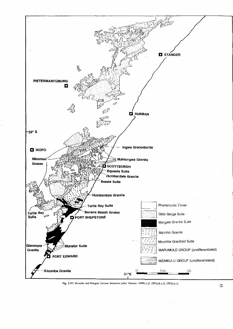
PIETERMARITZBURG
D
D IXOPO
Gneiss
Granite
Sikombe Granite
D STANGER
D DURBAN
~~~t'i';4<~~-J-- Ingwe Granodiorite
Mahlongwa Granite
Equeefa Suite
Humberdale Granite
Humberdale Granite
Turtle Bay Suite
Banana Beach Gneiss
PORT SHEPSTONE
o
I Phanerozoic Cover
:==~ ,--~~,--,I Oribi Gorge Suite
Margate Granite Suite
Mzimlilo Granite
Mzumbe Granitoid Suite '---_---I
r=~ill MAPUMULO GROUP (undifferentiated)
§=:~ MZIMKULU GROUP (undifferentiated)
Iml 50
Fig. 2.17: Mzumbe and Margate Terrane Intrusives (after Thomas, J990b,c,d; J99Ja,b,c,d; J992a,b,c).

56
syntectonic Oribi Gorge Suite (Figs. 2.17 and 2.18) was emplaced at between 1030 to 1070
Ma (Thomas et al., 1992g) and includes the megacrystic granitoids and charnockites of the
Valley of a Thousand Hills and those in the Stanger-Mapumulo area. Major bodies have been
recognised from southern KwaZulu-Natal (Port Edward pluton) to the Lovu River in the north
(K waLembe pluton).
The Mbizana Microgranite (Thomas, 1992c) was previously included in the Belmont Suite.
Geochemical and isotopic studies on the microgranites however, revealed that they were of
different age and mineralogical/geochemical character (Thomas et aI., 1990b). The Mbizana
Microgranites represent the youngest intrusive unit in the southern part of the NMP and are
related to the cessation of magmatism in the NMP (Thomas, 1992c), dated at 1026 ± 3 Ma
using U-Pb zircon data (Thomas et aI., 1993b). According to Thomas et ai. (1994b), the
younger Rb-Sr whole-rock and mineral ages of - 950 Ma (Eglington et al., 1986; Thomas et
al., 1993c) previously obtained are a sign of the prolonged, near-isobaric cooling of the entire
complex (e.g. Grantham et aI., 1993).
Table 2.18: Late- to Post-tectonic Intrusives of the Mzumbe and Margate Terranes
I Intrusive Body I Description I Aplite alaskite, Sheets and dykes of various ages. pegmatite
Mbizana Microgranite Fine- to medium-grained, subvenical to venicaI, grey micro granite dykes with no (Thomas, 1992c) tectonic foliation. Intrude and contain xenoliths of the Margate Granite and cross-cut
the local regional metamorphic fabrics.
Belmont Suite (Thomas Poorly foliated to unfoliated, medium-grained, equigranular, leucocratic biotite et aI., 1990b) granites. Intrudes gneisses of the Mapumulo Group.
Oribi Gorge Granitoid Consists of a number of extensive plutons (Fig.2.14) of coarse-grained, porphyritic, Suite (Thomas, 1991e) (pink or grey) rapakivi granite and dark green charnockite. Some intrusions are
completely granitic, while others are exclusively charnockitic, though granite and charnockite are present in most bodies. Intrusive into gneisses of the Mapumulo and Mzimkulu Groups and plutonic rocks of the Margate and Tunle Bay Suites, Mkomazi Gneiss and the Mzimlilo Granite. Xenoliths of country rocks are concentrated in zones at margins of the intrusions.
Sezela Suite (Evans et Consists of a number of sheet-like intrusions and two larger, pluton-like bodies. aI., 1991) Comprises mainly medium- to coarse-grained pink syenitoids (syenite, quartz syenite,
quartz monzonite, granite) and grey syenitoids (monzonite, quartz monzonite, granite). Rb-Sr whole-rock isochron age of 951 ± 16 Ma (Eglington and Kerr, 1989). Intrudes Mapumulo Group gneisses, Humberdale Granite and Equeefa Suite. Xenoliths of counlIY rocks common at intrusive margins.
Ingwe Granodiorite Single, lens-shaped body up to 1 km thick consisting of medium- to coarse-grained, (Thomas, 199Oc) unfoliated to weakly layered. quartzose leucogranodiorite. Intrudes gneisses of the
Mapumulo Grou]) and tonalitic gneisses of the Mzumbe Granitoid Suite.

Grey'own
® o to 40hm =~~=~
." TUGELA
~PIIa".rOloiC cover
Stan"" o
ffiZJ Orlbl Goroe Granitoid Suite
D Othtr Notal Mttamorphlc Prayinct rocks
~ Stratotype
-!fe,
'0'
Figure 2.18: Distribution of the Oribi Gorge Suite, with Informal pluton names (after Thomas. 1991e).
57

58
CHAPTER THREE
3. Metallogenic Framework: The Archaean Rocks of KwaZulu-Natal
Introduction
Mineralised Archaean rocks in KwaZulu-Natal are represented by the Nondweni and Melmoth
granite-greenstone remnants and Late-Archaean Pongola Supergroup volcanics and sediments.
In this chapter all the important metalliferous mineral deposits of KwaZulu-Natal in rocks of
Archaean age are documented. Important industrial mineral deposits are also mentioned. Gold
mineralisation is discussed in detail, using data from authors who have worked in the area.
Placer gold deposits are especially significant in light of the recent correlation of the Mozaan
Group with Witwatersrand stratigraphy (Beukes and Cairncross, 1991). The deposits are
grouped according to mineralization styles, where applicable. Minor occurrences are tabulated.
Production statistics from some of the workings are also included.
Archaean Lode Gold Deposits
Archaean lode gold deposits in the Province are hosted in both the older granite-greenstone
remnants and in the Late-Archaean Pongola Supergroup (see section 3.3). The various lode
gold deposits of the Province are documented along with descriptions of the individual
deposits. Aspects of the genesis and general characteristics of lode gold deposits follow in
chapter five, to provide a better understanding of the processes involved in the formation of
such deposits.
3.1. The Granite-Greenstone Terrane
Characteristics of the most important lode gold deposits hosted in the granite-greenstone
terrane of K waZulu-N atal are summarised in Table 3.1. Detailed descriptions of individual
deposits follow.

59
Table 3.1: Characteristics of some Archaean Greenstone Belt Gold Deposits of KwaZuluNatal
Mine/Prospect Host Rocks Deposit Type Ore Mineralogy Name
Golden Valley Nondweni Steep NE-dipping, oblique-slip Au + quartz with [I] Greenstones shear zone with superimposed minor Py, Cpy,
(volcanics) N-dipping, brittle-ductile shear Bn. Aspy. zones which host the auriferous Aurostibite. quartz reefs. electrum and silver Mineralising fluids rich in present as discrete KoO. SiOo, S and CO,. phases.
Sisters Occurs within a Three generations of quartz Ankeritic dolomite, [1](2] carbonatised and veins and quartz filled en fuchsite, quartz.
silicified calc- echelon tension gashes in arsenic, native Au, silicate unit highly fractured host rocks. pyrite, Aspy, (mainly altered Host rock is highly competent, goethite. komatiite or in contrast to the surrounding komatiitic basalt) talc schist. enclosed by talc CO2 and HzO rich alkaline schists fluids. Could extend for some
distance downplunge.
Enterprise Pillowed Steeply dipping quartz vein Au + quartz, Py, [1] komatiitic basalt Po and Cpy.
Goodrickes Mafic schist Cupriferous quartz veins show Au + quartz, Cpy Workings xenolith in highest gold values. [3] Nondweni Four anomalous sulphide-
Greenstones bearing zones with generally low gold values but elevated base metal concentrations.
Harewood Highly altered Second generation quartz reefs Tourmaline [4] trondhemitic in a steep, S-dipping brittle- (schorl),
gneisses, quartz- ductile shear zone which is specularite, native sericite schists related to a larger shear zone. Au + quartz, Po,
Mineralising fluids were not sphalerite COz-bearing.
Vira Metalavas altered Second generation ferruginous Goethite from the [4] to a chl orite- quartz veinlets and quartz weathering of Fe
quartz infilled extension fractures in sulphides. assemblage. the central (clay-rich) part of
the major shear zone.
Py = pyrIte. Cpy = chalcopyrite, Bn = bormte, Aspy = arsenopyrIte, Po' =; pyrrhotite [1] - Bullen et ai, (1994); [2] - Versfeld (1988) [3] Brown, (1988b) [4] Bullen (1990, 1991)
3.1.1. Nondweni Group
3.1.1.1. Golden Valley Mine
Alteration
Late pervasive carbonate alteration.
Carbonate alteration silicification and fuchsitization.
No alteration envelope is present
Talcification
Carbonatisation is absent. Argillic, sericitic and chloritic alteration well developed.
Argillic, sericitic and chloritic.
This mine occurs some 15 kIn south-east of Vryheid (Fig. 3.1) on the farm Golden Valley
13508 HT, in rocks which have been correlated with the Nondweni Group (McKenzie, 1992).
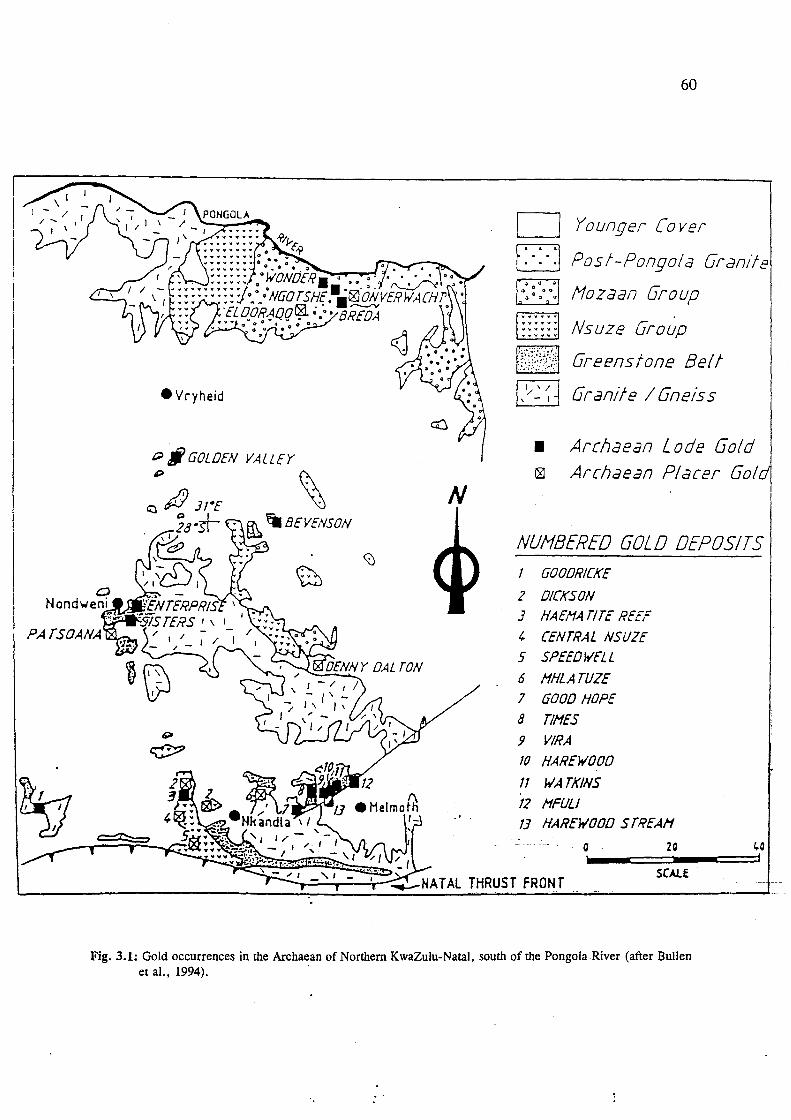
• Vryheid
t;;J # GOLDEN VALLEY
~ N
PATSOANA
60
D Younger Cover
D Pos/-Pongo/a Granite
!1ozaan Group
p:::::j Nsuze Group
t.~?1~?&?1 Greens fone Be! t
1,1/ ~ ~ J Grande / Gneiss
• Archaean L ode Gold ~ Archaean Placer Go!
NUHBERED GOLD DEPOSITS 1
2
J 4
5 6
7
8
9 10
11
12
13
GOODRICKE
DICKSON HAEI14 TITE REEF
CENTRAL NSUZE SPEEDWELL
I1HLATUZE GOOD HOPE
TlI1ES VIRA HAREWOOD
WATKINS I1FULI HAREWOOD S TREAI1
o 20 ,
SCAlE
1,.0 I
Fig. 3.1: Gold occurrences in the Archaean of Northern KwaZulu-Natal, south of the Pongola River (after Bullen et al., 1994). ..

61
The gold is hosted in approximately 1 m wide auriferous quartz reefs within steeply north
dipping, brittle-ductile shear zones that were superimposed on the steep northeast-dipping
oblique-slip Golden Valley Shear Zone, as a result of progressive deformation.
Detailed geological studies by McKenzie (1992) and Bullen et al. (1994), have revealed that
evolving hydrothermal fluids rich in K20, Si02 , S and CO2 ' appear to have exploited
structural discontinuities in the sheared greenstones, depositing silica and gold in the E-W
trending shear zones, accompanied by extensive carbonate alteration. Mineralisation occurs
mainly as free gold, though minor amounts are associated with pyrite, chalcopyrite, bornite
and arsenopyrite. Portions of the reef which are rich in native gold also contain aurostibite,
electrum and silver as discrete phases.
This deposit was first worked in 1884 and production took place intermittently until 1959.
Small-scale production resumed in 1980, initially with the reprocessing of the old slimes dams,
then in the underground workings. According to Bullen et al. (1994), this mine contains many
potentially exploitable reefs and viable small-scale production should be sustainable once
systematic and detailed prospecting of the structurally lower, quartz lodes has been undertaken.
Refer to Table 3.3 for production statistics.
3.1.1.2. Nondweni Goldfield
At the tum of the century, gold was produced on a small scale from two mines, the Enterprise
and Sisters Mines (Table 3.3), and various small prospects within the Nondweni Greenstone
belt (Fig. 3.2). In this goldfield, the mineralisation is hosted by mafic to ultramafic rocks of
the Witkop Formation. Gold bearing quartz veins occur mainly within pillowed and komatiitic
basalts and carbonated komatiites (Versfeld, 1988). Numerous small prospects occur, - ~ -.
predominantly in the northern limb of the greenstone belt on outcrops of Witkop Formation
meta-basalt. These workings targeted the steeply dipping quartz veins in the pillowed and
komatiitic basalts. The locations of these small workings, which were given names by the early·
prospectors, are shown in Fig. 3.2. Based on the size of excavations· and dumps, very little
production is assumed to have occurred from these prospects.

LOCALITY MAP: MINERALISATION IN THE NONDWENI GREENSTONE BELT
~ '.
TOWN
5 o 'km ,
Au Au POlSOOl10
WELVERDIEN 354
WITKOP 308
NONDWENGO 407
KROMELL£N800G 266
Mineral Oco.rrences/Prospects I Abondmed Mines
Au GOLD
Cu-Zn COPPER - ZINC
W TUNGSTEN
A ASBESTOS
C GRAPHITE
T TALC
::: ROADS
~ RIVERS
/ FARM BOUNDARY
Base I· 50 000 TODocadoslrol sheet 2B30 88
Fig.3.2:Mineral occurrences in the vicinity of Nondweni. northern KwaZulu-Natal (after Versfeld, J 988).
0'1 N

63
3.1.1.2.1. Sisters Mine
The mine is situated some 6 Ian southeast of N ondweni on the fann Lot 4 N ondweni 10634
(Fig. 3.2). The mineralisation is hosted in a 50 m thick calc-silicate unit enclosed by talc
schists. The calc-silicates display remnant spinifex textures implying that this unit represents
highly altered spinifex textured komatiite or komatiitic basalt. In addition, these calc-silicates
are intensely carbonatised and silicified and were exploited in zones comprised entirely of
ankeritic dolomite, fuchsite and quartz. Mineralisation is concentrated in quartz veins and
stringers which are situated below a 2 m thick, north-dipping chert unit. Some of the old
workings also exploited quartz-filled en echelon tension gash fractures (Versfeld, 1988). The
quartz veins comprise an early generation of narrow stringers and veins which has been cross
cut by a second generation of coarser-grained veinlets. The last generation cross-cut the earlier
sets of quartz veins.
There are no accurate records of past production. Channel sampling across the old excavations
by Versfeld (1988) returned a maximum value of 1.3 glt Au over 1 m, while sampling of
diamond drill core gave a maximum value of 0.19 glt Au. At the Sisters Mine, Versfeld (1988)
proposed that gold was leached from an earlier, relatively gold-enriched, carbonatised
alteration envelope by CO2 and H20-rich alkaline fluids, and concentrated in residual silica-rich
fluids. These latter fluids precipitated within fractures in the carbonate rocks. Hydrothennal
fluid/wall rock reactions are also thought to have influenced the selection of favourable sites
for gold deposition, as no significant gold mineralisation was found in the relatively non
reactive overlying chert units, which may also have acted as an impervious barrier to the
mineralising fluids.
Investigations by the South African Development Trust Corporation (STK) (De Klerk, 1987),
also revealed that the best gold grades were situated in the highly fractured and altered
carbonate rocks. However, De Klerk states that the mineralisation in this unit was probably
the result of the intense fracturing, which was used by the mineralising fluids as conduits eri
route to the final site of Au deposition located stratigraphically higher in the- volcanic-pile, and .
which has subsequently been removed by erosion.

64
3.1.1.2.2. Enterprise Mine
These workings, just north of the Sisters Mine on the farm Lot 6 Nondweni 10878 (Fig. 3.2),
are found in a steeply dipping quartz vein up to 1 m thick which is hosted in east-west
striking, sub-vertical, pillowed komatiitic basalt. No characteristic alteration envelope has been
recognised in the host rocks over the 600 m strike length of this vein. Pyrite, pyrrhotite and
minor chalcopyrite is present in vein quartz found in the old dumps. Versfeld (1988) proposed
that the Enterprise and other minor Au vein deposits in the area were formed by hydrothermal
fluids leaching gold from lower levels in the greenstone succession and then precipitating it in
dilational structures at higher levels in the more competent lithologies (Versfeld, 1988). No
recent prospecting has been done in this area, which is densely populated.
3.1.1.3. Goodrickes Workings
These old workings occur some 45 km west of Nkandla (Fig 3.1) within the Sifula inlier of the
Nondweni Group. Cupriferous quartz veins, hosted in a mafic schist xenolith, were exploited
at the tum of the century (Bullen et aI., 1994). Brown (1988b) identified four anomalous
sulphide-bearing zones (Table 3.2), each of which contained trace amounts of gold, along with
elevated base metal (Cu, Zn, Co) and Ba concentrations.
Table 3.2: Characteristics of the Sulphide-bearing zones at Goodrickes Workings (after Brown, 1988b).
Zone Description Highest Element Concentrations
A Meta-argillaceous horizon with disseminated sulphides at base Cu: 75 ppm; Co: 400 ppm, which are underlain by layered, highly altered felsic volcanics. Zn: 547 ppm.
B Banded iron formation containing disseminated sulphides which Cu: 351 ppm overlie an ultramafic unit which has been subsequently altered to Zn: 1183 ppm talc. Co: 441 ppm
C Intensely folded and altered felsic tuffs and meta-argillites. ' Au: 300 ppb. containi~ a thin mineralised horizon with elevated Au values.
D Highly sheared ultramafics (with locally developed chrysotile) Cu: 1 246 ppm. and meta-argillites which are enriched in sulphides along the Low Au concentrations. shears.
The highest gold value reported was 4.9 ppm in a quartz reef of limited strike length (40 m).
The limited size of the deposit coupled with its relative inaccessibility militate against its being
viable at present. Further prospecting is, however, recommended.

65
3.1.2. Melmoth Granite-Greenstone Remnant
Six quartz vein-hosted gold deposits have previously been worked in this remnant. For
production and grades, the reader is referred to Table 3.3. Bullen (1990, 1991) completed a
detailed study on the mineralised part of the greenstone succession (see section 2.1.1.3). Four
phases of deformation and metamorphism were recognised in the greenstones, which comprise
mainly mafic metalavas with minor serpentinite, talc schist, dacitic tuff, quartz-muscovite
schist, quartzite and calc-silicate rocks. Syn-tectonic trondhjemitic gneisses, late-tectonic
granodioritic gneisses and post-tectonic granite dykes, form the main intrusive phases. The
inaccessible Times, Watkins, Mfuli and Good Hope deposits have not been explored in detail,
however Bullen's (1990) study covered the Harewood and Vira workings in detail.
The Harewood workings occur in highly altered trondhjemite (now quartz-sericite schists),
while at the Vira deposit, the workings are located in metalavas, just below the contact of the
Natal Group sandstones. Mineralisation at both localities is confined to shear zone-hosted,
second-generation quartz veins, which cross-cut earlier barren, and texturally different quartz
veins. The mineralised veins are composed of medium-grained, equigranular quartz, with
minor tourmaline, specularite and sericite. Pyrrhotite, sphalerite and native gold occur in trace
amounts. These quartz veins are confmed to the centre of a major east-west-trending, brittle
ductile, steep, southerly dipping shear zone. This shear zone was generated during the
emplacement of a late-tectonic granodioritic pluton. Gold was concentrated in economic
quantities (up to 5.6 ppm) in dilational sites which formed due to refraction of the shear zone
as it crossed the different lithologies. The mineralised veins are arranged en echelon as they
were deposited parallel to "P" shears, thus forming oblique shear veins. Quartz-infilled
extension gashes also contain trace amounts of gold. The central part of the shear zone has the
most intense shearing and may have been highly permeable, allowing the ingress of large
volumes of hydrothermal fluids necessary for the formation of the gold deposits.
The Harewood and Vira deposits exhibit similar wall-rock alteration features (e;g. -
sercitization, chloritization) despite the fact that they are hosted in different rocks. This -
suggests that both deposits formed under similar conditions and that the mineralising fluids
were of a uniform composition. From mineralogical studies, these fluids were considered to
be of both magmatic and metamorphic origin. Magmatic fluids, believed to have been-

•
66
generated by the intruding granodiorite pluton during pressure release and magma
crystallisation, were oxidising in nature and deposited the silicate and oxide phases. The
contact metamorphic effect of the pluton on the adjacent greenstones resulted in later,
chemically reduced metamorphic fluids which deposited the sulphide phases and Au.
Deposition of the gold was principally in response to fluid/wall rock interaction. Though
similar wall rock alteration is present at both deposits, sericitization dominates at Harewood
(because of the original granitic host rocks), whereas chloritization is more prevalent at Vira
because of the mafic nature of the original lavas. Argillic alteration is pronounced immediately
adjacent to the orebodies, and this is surrounded by a wider halo of chloritic alteration.
Table 3.3: Summary of available production statistics for greenstone-hosted lode-gold deposits in KwaZulu-Natal.
I Mine/Working Name II Production Period I Production I A vera&e grade I Golden Valley 1884 - 1887 ---- To date, ± 54 kg Au produced
1890 - 1910 ---- at an average grade of 5.46 g/t. 1910 - 1932 10 kg Grades highly variable, with up 1932 1.6 kg from 329 t to 25 g/t in places. Some 1953 - 1959 ---- exposed quartz reefs give values 1980 ~ 1992 ± 40 kg from 8 700t of 40 - 60 g/t (Bullen et aI.,
1994).
Enterprise Mine 1887 - 1899 90 kg ± 7 g/t (Hammerbeck, 1976) Sisters Mine
Harewood ± 1894 - 1909 l3 kg from 709t I01A .J.
Vira as above 9.31 kg from 1222t 7.63 g/t
Times as above 0.93 kg from 926t 1.01 g/t
Watkins 3.79 kg 3.70 giL - ~ ~ ~
[Data from Bullen et al. 1994, Bullen, 1990.(obtamed from CommISSlOne!,ofmmes reports and Du TOlt, 1931).]

67
3.2. Pongola SuperjUoup: Placer Gold Deposits
Archaean placer gold deposits are restricted to the northern parts of the Province and occur in
the sedimentary lithologies of the N suze and Mozaan Groups of the Pongola Supergroup (Fig.
3.1). These deposits attracted attention mainly because of stratigraphic and other geological
similarities with the richly mineralised Witwatersrand conglomerates. This correlation was
confirmed by Beukes and Cairncross (1991) (see chapter 5). However, the complex fluviatile
systems that re-concentrated the mineralisation in the Witwatersrand Basin appear to have been
absent in this area (Dix, 1984), and extensive, high-grade gold deposits have not yet been
located. Mineralisation was impersistent and all the old workings have been abandoned.
3.2.1. Nsuze Auriferous Conglomerates
These conglomerates, which were worked in the early 1900's, are exposed in the Nsuze River
gorge, some 12 km west of Nkandla. According to Bullen et al. (1994), three large synclines
host the mineralised conglomerates, quartzites and phyllites of the Nsuze Group. The South
and Central N suze synclines plunge to the west at 30 to 40 a and the North N suze syncline
plunges to the east at 20 0• The synclines are separated by thrust faults so direct lateral
correlation between the three synclines is impossible. Gold occurrences have been documented
in each of the three synclines.
3.2.1.1. North Syncline: Dickson Mine
This mine is located on the farm Qudeni 34 and the old workings consisted of adits and
trenches in two zones of steeply north-dipping, pyritic conglomerate. The reefs, up to 35 cm
thick, can be traced for 6 km along strike. Total production recorded from this early venture
was about 760 g Au at an average grade of 10 glt (Hatch, 1910). Drilling carried out during
the last exploration attempt in the area indicated that ga.l,d grades decreased with depth, from
9 glt at surface to 1 glt below the water table, which is suggestive of supergene enrichment
(Bullen et al., 1994). The drilling also showed that the mineralised shoots had a limited lateral
extent and the gold was very erratically distributed within them,- which suggests that they
would be sub-economic.

68
3.2.1.2. Central Syncline: Central Nsuze Reef
These workings were mined unsuccessfully during 1903-1904 and consisted of 5 inclined shafts
and 14 small adits (Weilers, 1990). The reef can be traced for 1 km along strike and contains
a well-developed ore-shoot grading at 6.93 glt Au over 87 cm (Winfield, 1982). This compares
with assays by Hatch (1910) who reported a highest concentration of 6.2 g/t. However, gold
distribution here is sporadic and projected reserves are SUb-economic.
3.2.1. 3. South Syncline: Speedwell Mine
These workings occur near the village of Ntingwe on the farm Qudeni 25. Mining was carried
out intermittently until the 1940's, and numerous adits and shafts are still visible over a width
of 80 m. The reefs are steeply dipping and can only be traced for 600 m along strike,
terminating against faults in the east and disappearing beneath younger cover rocks in the west
(Bullen et aI., 1994). There are no production records from the old ventures, however Hatch
(1910) analyzed 10 conglomerate samples from this mine, which yielded an average of 3.1 glt
Au over a sampling width of 45 cm.
3.2.1.4. Cooper's Store/Randalhurst Gold Occurrence
This 1 to 4 m thick auriferous N suze Group conglomerate layer crops out in the Mhlatuze
River valley, south of the Nkandla-Melmoth road, some 10 km northeast of Nkandla.
According to Saager et al. (1986), the mineralised conglomerates are clast-supported, with
elongated pebbles and are very well mineralised in parts. Also recognised in these layers are
detrital pyrite, pseudomorphic haematite and Fe-hydroxides. Up to 1910, 105 tons of ore were
mined from several shafts and adits on the mineralised conglomerate zone, yielding ± 288 g
of gold at an average grade of some 2.7 glt (Hatch, 1910). As the general tenor of the reef was
low, the workings were abandoned.
3.2.1.5. Patsoana Prospect
This prospect is situated some lOkm south of Nondweni on Bantu ReserveNo.187638. The
2.5 m thick conglomerate unit prospected here occurs near the base of the Nsuze Group and
is overlain by cross-bedded quartzites and grits (Versfeld, 1988). The adits, pits and trenches
here were abandoned prior to 1900 as the workings were not profitable. Channel sampling by
Versfeld (1988) indicated a peak assay value of 0.55 glt in this matrix supported conglomerate;-

69
and the clasts, mainly chert, quartzite and vein quartz, are considered to have been derived
from the Nondweni Group. The low concentration of gold in the Nsuze Group in this vicinity
was attributed by Versfeld (1988) to the immaturity and polymict, matrix-supported nature of
the conglomerates.
3.2.2. Mozaan Auriferous Conglomerates
3.2.2.1. Denny Dalton Mine
The Denny Dalton mine, which operated intermittently between 1894 and 1930, is situated 38
kIn northwest of Melmoth on the farm Tusschenby 411. A total of about 14 kg of gold was
produced from this mine. According to Saager et al. (1986), a basal conglomerate layer, which
overlies a 30 m thick quartzitic sandstone unit at the base of the Mozaan Group at Denny
Dalton, constituted the prime target for mining as it closely resembled the Witwatersrand ores,
in both mineralogy and texture. Dix (1984) noted some fluvial reworking of the conglomerates
at Denny Dalton, which he believed, had been responsible for the upgrading of the heavy
mineral content. However, this process did not seem as effective or long lasting here as it must
have been in the Witwatersrand deposits.
The auriferous horizon, known as the Mozaan Contact Reef (MCR) is up to 7 m thick and
contains large (up to 1 cm), rounded, compact pyrite grains, arsenopyrite and minor brannerite
(Saager et al., 1986). This is followed by an upper layer where small pyrite grains occur,
disseminated in the conglomerate matrix, or concentrated in fore sets of cross-bedding. The
clasts consist mainly of vein quartz and chert; Economically exploitable mineralization was
only found in the lowermost 0.5 to 1.0 metre of this reef, which dips at between 5 and 10°
east-northeast and crops out intermittently over a strike length of 10 km (Bullen et al., 1994).
The old mine workings, which consist of open pits and adits, are situated in a stream bed - ~ -.
which has exposed the reef. The highest grades (around 20 g/t) were reported from near-
surface ore, which suggests supergene enrichment (Bullen et al., 1994). Recent exploratory -
drilling revealed a maximum down-dip extent of the MeR to be less than 600 m from the -
surface, which would not make this a viable mining venture.

70
3.2.2.2. Gunsteling
On the farm Gunsteling 21 on the north bank of the Pongola River, a few layers of sulphide
minerals occurring in a 7 m-wide conglomerate zone in quartzites of the Mozaan Group, were
investigated by Saager et al. (1986). In addition, relatively high U and Th contents were found
in the phyllites underlying the conglomerate zone. At the base of the Mozaan Group is an
alternating sequence of clast- and matrix-supported conglomerates. The auriferous
conglomerate layers were found to occur in the clast-supported, upper part of the zone, which
also contains limonite pseudomorphs after sulphide minerals. No production has been recorded
from this occurrence, however 3 m deep trenches indicate that some gold prospecting has been
attempted in the past.
3.2.2.3. Eldorado and Onverwacht
Two gold-bearing Mozaan Group conglomerates were discovered on the farms Eldorado 13
and Onverwacht 395, at the turn of the century (Humphrey and Krige, 1932). In 1915, about
5 kg of gold was mined from 624 tons at Onverwacht, the workings having since been
abandoned. Gold grades on these farms vary between 0.8 and 3.1 glt at surface and have
generally been considered uneconomic because of the limited extent of the ore horizon.
3.3. Pongola Supergroup:Lode Gold
The quartz lode gold aeposifs in the supracrustal Pongola Supergroup show many similarities
to the lode gold deposits found in the underlying granite-greenstone terrane. These epigenetic
deposits are also structurally related and the mineralisation was precipitated from deeply
sourced hydrothermal fluids. Characteristics of some of mese deposits are summarised in Table
3.4.

Table 3.4: Characteristics of some Archaean Lode Gold Deposits in the Pongola Supergroup
Mine/Prospect Host Rocks Deposit Type Ore Alteration Name Mineralogy
Klipwal Mine Shales, quartzites and Gold in syntectonic quartz and Arsenopyrite, Phyllic, (Gold, 1993) diabase sills (Mozaan carbonate veins within the Pyrite, chloritic,
Group) Klipwal shear zone and Pyrhottite, carbonaceous disseminations within the host chalcopyrite, rocks and in fault gouge native Au
Wonder Mine Shales of Mozaan Group Shear zone-hosted, steep NE- Pyrite, native Ferric (Bullen et aI., dipping quartz reefs related to Au 1994) the major strike-slip Bumbeni
Shear. Supergene enrichment at surface
N gotshe Mine Quartzites and Saddle-Reef type where Pyrite, native N/A (Bullen et aI., ferruginous shales of mineralised quartz veins occur Au 1994) Mozaan Group in the core of a steeply NE-
plunging anticline, the western limb of which was displaced by the Klipwal Shear.
Kortnek Quartzite and shale Located on or near an E-W zone Quartz, pyrite, N/A Prospect (Mozaan Group) of thrusting. Sub-horizontal chalcopyrite, (Weilers, 1990) mineralised shale beds and native Au.
mUltiple auriferous quartz veins located on the axis of an open anticline.
Bongaspoort Ferruginous shales Subparallel, auriferous quartz Native Au, Argillic, Prospect (Mozaan Group) reefs which cross-cut the host Pyrite, ferric and (Brown, 1989) lithologies. Related to a brittle- chalcopyrite. silicic
ductile shear zone and Enriched in hydrothermal fluids. base metals Three mineralised zones (Cu, Zn, Pb) comprising:l] A Main Quartz and arsenic. Vein with subsidiary veinlets; 2] Fe-rich shale horizon; 3] A lower quartz vein
Altona Shales of Mozaan Group Disseminated sulphides (Py and Pyrite, N/A (Weilers, 1990) Cpy) in BIF and shales. Chalcopyrite.
Associated with NW -trending shear or wrench faults. Mineralisation not continuous at depth. -
71

v
v -/ v
'I V v
v v
v v
v
v
v
,j v
" 'I
'I 'I
>J V
v
1/ v
1/ v 1/ v v
v Ii 'I v v
v v v
" v
'-
o O~
V V V a ()" :--- '--",----o ~
V '( V V 0 0 0 ;;-- ('---~ V V a 0 0
v V II 0 0 0 0 ~o 0 0
KWAZULU-NATAL' v v v
31 °15
! SWAZILAND
v v
v
~ N
);
+ r'-
1- ~ o " + '\~
~ -:-', '"
o ' ~ r + "-
, , , 0 " _ "'~ 0
0
0 0 \~~ 1- +
o 0 o~~ 0' f-o ~
o '" 0 0
o 0 V o DO} (I
v
V v
C Deposit
km 5
v
v v
o v o Ed E-=-""3 C -]
·250000
v II
v o o
vi s c A L E
v v, 0
" o o v o
'i .;
v' '0 o -;-o vi ,j a
1-
v o o
V o a
a o
" V~vI V 10 V V
/0 1/
o
o
o o
a 0 CKo~nek 0 QO I~ ~ 1-
o 0 0 0 -j-." l·r .J._V:+-o ,~/o
" T\_, -'- v-:
o
o
v
v
v
v
v V
'I a
v
v
v
o
o
o
o o
o o o
o "
o a
o 0 0 --., v'Vt"' /'
CD 0 '- '- J '+-- ~'~ +-../
-, 0 / 0 "K/ip_waJ c,\ 0 ~ r + <> ,00 0 ~ 0 •
v 0 \r..::go/~ ~ R-(.;""",r'''- ~Jo ~'"(~, o 0 -"""\ ; o 0 0
a 0 DNo.nder
" a
a
o o o
o o a o o o
o a o o
o c--' \.l.~ ( 0
..9. o
a o
o
r../ --"0 o o o o 0(\
CNgotshe' v-v
o . ./ R. o 0 Q 0
• 0 0 0
a o a a o YOUNGER COVER o o
.. 0 0 0 0
V VV ~
o CBreda MOZAAN GROUP
I) a o
V V Ii ---.~- .. ---~ NSUZE GROUP a o
,: ~~Eldor:do o a
o ( a
o o o r;-:tl ~GRANITE
a o 0
Q
Fig 3.3: Gold occurrenct!s hosted in the Mozaan Group in nonht!astt!C!l K waZulu-Na[al (after Brown. 1989).
o o o
i,.,

73
3.3.1. KlipwaI Gold Mine
The Klipwal Mine (Figs. 3.3 and 3.4) is currently the only producing gold mine in the
Province. The mine is situated some 35 kIn southwest of Pongola in northern KwaZulu-Natal,
on the fann Klipwal 49 HU. The gold mineralisation is hosted in the shales and quartzites of
the Mozaan Group as well as in intrusive dolerites. The mine is located within the Klipwal
Shear Zone (Fig.3.3), a north-trending, east-dipping structure that is identified from north of
the Pongola River southwards (Bullen et al., 1994).
The largest concentration of gold is found within the main shear zone, where it is associated
with syntectonic quartz and carbonate veins (Gold, 1993). Gold and sulphide mineralisation
is also found disseminated within the silicified and sericitized hanging wall quartzites and
footwall shales, as well as in deformed intrusive dolerite dykes. Minor ore bodies occur in
variably orientated secondary fractures and faults in the hanging wall. Gold is also present in
fault gouge, which has abundant quartz veining, and has developed between the quartzites and
shales. Normal faults at this locality are known to displace strata from a minimum of 800 m
up to 3.5 kIn. The complex pattern of veining developed here was attributed to the sequential
development and distortion of the veins during progressive deformation (Gold, 1993).
The structural deformation and gold mineralisation at Klipwal was attributed to the intrusion
of the Spekboom granite by Weilers (1990). Matthews (1990) also attributed some of the
tectonic stresses in the Pongola-Mozaan basin to the intrusion of granitoid plutons. However,
detailed structural analyses by Gold (1993) and Gold and Von Veh (1995) revealed that the
effects of the intrusions are very localised, whereas deformation in the Pongola-Mozaan basin
is regionally persistent. They ascribe deformation in the basin to an early north-northwest
verging thrusting event associated with north-directed thrusting described from many other
parts of the Kaapvaal Craton (reviewed in De Wit et at:, 1992, cited in Gold and Von Veh,
1995).
From detailed mineralogical studies at Klipwal by Russell (1985; cited in Gold, 1993) it was· - .
concluded that the ore was deposited from hydrothermal solutions introduced into the shear
zones from the following evidence:

(i) an association with quartz veining
(ii) wall-rock alteration
74
(iii) decrease in the ore grade away from the shear zone (indicating high permeability in the
centre of the shear zone).
Also noted from the association of arsenopyrite-pyrite-pyrrhotite was that the temperature of
formation of the gold mineralisation was in the order of 350 to 400° C (i.e. mesothermal).
According to Gold (1993), broad, generally barren pyrite veins cross-cut the shear fabric of
the host rock whereas narrower auriferous veins of pyrite are concordant with it.
Contemporaneous deposition of gold with sulphides is confirmed by their intimate textural
relationship. Detailed mineralogical studies by Russell (1985) showed that 52 vol % of the gold
is associated with pyrite, 22 vol % is associated with arsenopyrite, and 7 vol % is associated
with fractures in pyrite or arsenopyrite grains.
The deposition of mineralisation here is typical of hydrothermal deposits, and was precipitated
in response to fluid/wall rock interaction. Abundant carbonate and phyllic alteration, typified
by the assemblage quartz-sericite-pyrite, was recognised at Klipwal. These types of
hydrothermal alteration are common in gold quartz lodes (Pirajno, 1992). Hydrothermal fluids
exploited the deep seated faults and ductile shear zones, which enabled the circulation of large
volumes of fluid. Most of the economic gold mineralisation is found in or near the centres of
the shear zones, where permeability is thought to be highest. It was also noted that only the
east-dipping shears (- 50°), contained gold, whereas the near-vertical shears are almost always
barren (pers. Comm. D. Gold, 1995).
Mining at Klipwal has been continuous since 1974 when the property was acquired by Lonrho
South Africa Ltd. Production since 1980 is about 3.5 tons Au, and current production runs at
approximately 500 kg per annum (pers. comm. R. Hobos, 1996).

f-<' f...._r_
f* ...
-".-
".
...
o I
KEY Thrust faull
Normal faull
Strike-slip fault
Axial trace
Anticline
Syncline
31"16'E
Strike and dip of beddtng
Strike and dip of folia lion and plunge of lineation
Bedding trace
tkm I
LEGEND
Q Dolerlle
~ Dlamictlle
D Mudstone. siltstone sandstone
/ River / __ ---.t:.
PoMola /
/1-- / f_--
\ \
/ '" \:. "" " , " ---_ ........ "-
"-" "- "- '-----
" '\ \
75
l'ig.3.4: Location of the KlipwaJ Mine and Geology of the KlipwaJ shear zone (from Gold and Von Veh. 1995).

76
3.3.2. Wonder Mine and Ross Reef
The Wonder Mine is situated some 5 kIn southwest of the Klipwal Mine in an area which is
now the ltala Nature Reserve and on which prospecting is not permitted. The mine was
intermittently worked between 1905 and 1933 (Table 3.5). Up to 1913, near-surface mining
was undertaken on the weathered, oxidised portions of the reef where supergene-enriched free
milling gold was exploited (Bullen et aI., 1994). The tailings, which contained refractory gold
in pyrite, were later treated using cyanidation.
Numerous quartz reefs are hosted in Mozaan Group shales and crop out in the steep-sided
Pongola River valley. According to Bullen et al. (1994), the northwest-trending, steep (- 70°)
northeast-dipping reefs, lie subparallel to the s-fabric of a north-south trending, strike-slip
shear zone and thus form oblique shear veins. They relate this structure to the Bumbeni shear,
which crops out to the north of the Pongola River. The reefs are situated about 20 m apart and
are between 0.10 and 1.22 m thick. However they are of limited strike extent. Some 2 km
south of the Wonder Mine, and along strike from it, the Ross Reef and Wonder extension reefs
are reported to occur (Weilers, 1990).
3.3.3. Ngotshe Mine
This mine is located 3 km southeast of Wonder Mine, also within the boundaries of the Itala
Nature Reserve (Figs. 3.1 and 3.3). According to Bullen et al. (1994), the mineralisation
occurs in three subparallel quartz veins lying 40 to 60 m apart, between hanging-wall quartzites
and ferruginous footwall shales of theMozaan Group. The reefs are up to 40 cm thick and dip
to the northeast at - 40°. In contrast to the reefs at Wonder Mine, the reefs here are either
bedding-parallel or cross-cut the bedding at a shallow angle. Weilers (1990) reported that, in
places, the wall rocks are also gold-bearing.
This mine lies a few hundred metres to the east of the Klipwal shear, which probably acted as
the principal conduit for the mineralising fluids. Mineralisation is located within the core of·· .
a steeply northeast-plunging anticline, the western limb of which was displaced by the shear.~
The fluids were moved along the shear and deposited the gold and silica in adjacent areas of
low strain. Mineralisation here, although related to a shear zone, is thus of a saddle reef type,
in contrast to Wonder Mine, which is shear zone-hosted.

77
Table 3.5: Production statistics from the Wonder and Ngotshe Mines (after Bullen et al., 1994)
I MineName I Production period I Production I Grade I Wonder Mine 1905 - 1913 126.5 kg Up to 35 glt recorded.
1919 - 1933 20.7 kg with average of 10 g/t
Ngotshe Mine 1911 - 1915 129 kg Average grade: 26 g/t 1943 - 1967 8.3 kg 1. 8 g/t
3.3.4. Other Lode Gold Prospects in the Pongola Supergroup
These occurrences, outlined below have previously been investigated, but were found to be of
no economic significance at the time. Where available, results and conclusions regarding the
potential of the deposit obtained from various exploration projects will be given.
3.3.4.1 Gold mineralisation on the Farm Kortnek
According to Weilers (1990), five mineralised localities are known to occur on the farm
Kortnek 50 HU, which lies northeast of the Klipwal Mine (Fig 3.3). Four of these, together
known as the Gorge Reefs, were investigated in 1945, and comprise subhorizontal mineralised
shale beds with associated quartz. The fifth prospect, referred to as the Mammoth Reef consists
of a northwest-dipping quartz, chlorite, sulphide body, with a quartzite footwall.
Investigations by Anglo American Corporation in the 1980's, usmg adits and trenches,
concluded that only two of the prospects had potential. Sampling on the first prospect indicated
an average grade of 13.8 g/t Au over a width of 58 cm, but this was of very limited extent. At
the other prospect, which comprises mUltiple quartz veins located on the axis of an open
anticline, trench sampling provided values ranging from 17 g/t Au over 60 cm, to 116 g/t Au
over 462 cm. The potential strike length was reported to be of the order of 300 m. Lomho' s -;- <
investigations comprised seven shallow diamond drill holes. Five of these returned values
ranging from 1.4 g/t Au over 158 cm to 96.0 g/t Au over 175 cm. This indicated a relatively
high grade ore shoot over a strike extent of 90 m (Weilers, 1990).
3.3.4.2. Gold Mineralisation on the Farm Bongaspoort
This farm (Bongaspoort 48 HU) also occurs in the Klipwal area north of the Pongola River,
some 40 km west of Pongola (Fig 3.3). Brown (1989) conducted a detailed investigation on

78
this farm for the South African Development Trust Corporation (STK). The mineralisation
style here was found to have many similarities with the other quartz vein deposits in the
Mozaan sediments in that it is related to shear zones. The ferruginous, sulphide-rich wall rocks
also show signs of mineralisation. Mineralising fluids exploited the semi-ductile shear zones,
depositing gold and silica, with the ferruginous shales providing an ideal chemical environment
for the precipitation of gold.
Based on geological mapping, geochemical and mineralogical studies, Brown (1989) concluded
that an epithermal or hydrothermal system was active along the shear zone that cross-cuts the
farm. This resulted in extensive leaching, associated with argillic, ferric and siliceous alteration
of the country rock. This alteration pattern is characteristic of hydrothermal mineralisation
normally related to gold mineralisation. Mapping and sampling of the old workings revealed
a series of subparallel quartz veins with an east-west strike that obliquely cross-cut the host
lithologies and three mineralised zones as follows:
(i) A Main Quartz Vein: 1-3 m thick, with subsidiary veinlets. Samples from the offshoot
veinlets revealed Au values of 3.5 and 9.2 ppm. The main Quartz Vein sample which included
shale xenoliths contained 9.1 ppm Au. The gold is associated with enhanced base metals (260-
630 ppm Cu; 70-240 ppm Zn; 20-700 ppm Pb) and As concentrations of between 260-3400
ppm.
(ii) An Fe-rich Shale Zone: Below (i), this zone contains a network of quartz stringers and
disseminated sulphides. Channel sampling revealed gold contents from 0.55 ppm to 6.90 ppm,
with an average grade of 2.75 ppm Au over 0.5 m. Associated with the gold are high
concentrations of copper (260-630 ppm Cu); lead (20-700 ppm Pb); zinc (70-240 ppm Zn) and
arsenic (260-3400 ppm As).
(iii) A Lower Quartz Vein: A 0.2 - 0.5 m thick sulphide-bearing quartz vein which outcrops
north of the old workings. Six grab samples revealed gold concentrations of 4.4 to 41.9 ppm
Au. Associated with the Au are copper (700-5100 ppm Cu); lead (200-3800 ppm Pb); zinc (40-
500 ppm) and arsenic (75-340 ppm As).

79
Pyrite and chalcopyrite were the most common sulphides associated with the Au
mineralisation. Brown (1989) suggested that, as gold mineralisation had been established here,
this prospect would be an excellent target area in the exploration for structurally controlled,
epithermal gold mineralisation.
Tennick (1990) reported a possible resource at Bongaspoort of 13 400 t at an average grade
of 2.8 glt over a strike length of 60 m, an average width of 4.0 m and an assumed downdip
extension of 20 m. A "Mixed Zone" was identified as containing the highest grades. This zone
comprises a fractured, ferruginous shale horizon containing numerous cross-cutting quartz
veins and stringers. Lower grades were reported from adjacent massive quartz veins and the
shalelgreywacke country rocks. A drilling programme was outlined by Tennick to test the
depth extent of the mineralisation and the strike extension of the "Mixed Zone". The possibility
of fmding other such "Mixed Zones" at depth was not discounted. No further work has been
reported since.
3.3.4.3. The Altona Prospect
A prospecting adit, soil sampling and trenching within banded iron and shales of the lower
Mozaan Group on the farm Altona 47 HU (Fig 3.3), revealed disseminated sulphide
mineralisation. Investigations by Lomho (Weilers, 1990) showed low-grade gold
mineralisation to a depth of 30 m associated with pyrite and chalcopyrite. Mineralisation over
a 32 m strike length in structurally disturbed ground yielded average gold grades of 2.06 glt
sampled over a width of 167 cms. The Altona prospect is apparently associated with
northwesterly trending shear or wrench faults (Weilers, 1990).
3.3.4.4. Haematite Reef
This occurrence (reported by Bullen et aI., 1994) was dis~overed in 1893 and is situated 12 km
northeast of Nkandla (Fig. 3.1) on Reserve No.19 7638. The orebody is hosted in quartzite
and phyllite of the Nsuze GroupandmineraIisation occurs in al m thick, bedding-parallel
quartz reef which contains cubic pseudomorphs of haematite after pyrite, with the haematite
giving way to pyrite at depth. Some exceptionally rich pockets of ore with grades of up to 204
glt gold were located. However, mineralization was sporadic and apparently refractory at
depth, which may cause beneficiation problems. These factors have rendered the reef
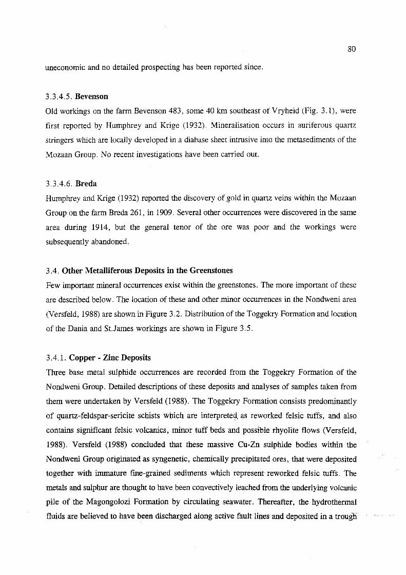
80
uneconomic and no detailed prospecting has been reported since.
3.3.4.5. Bevenson
Old workings on the farm Bevenson 483, some 40 kIn southeast of Vryheid (Fig. 3.1), were
first reported by Humphrey and Krige (1932). Mineralisation occurs in auriferous quartz
stringers which are locally developed in a diabase sheet intrusive into the metasediments of the
Mozaan Group. No recent investigations have been carried out.
3.3.4.6. Breda
Humphrey and Krige (1932) reported the discovery of gold in quartz veins within the Mozaan
Group on the farm Breda 261, in 1909. Several other occurrences were discovered in the same
area during 1914, but the general tenor of the ore was poor and the workings were
subsequently abandoned.
3 .4. Other Metalliferous Deposits in the Greenstones
Few important mineral occurrences exist within the greenstones. The more important of these
are described below. The location of these and other minor occurrences in the N ondweni area
(Versfeld, 1988) are shown in Figure 3.2. Distribution of the Toggekry Formation and location
of the Dania and St.James workings are shown in Figure 3.5.
3.4.1. Copper - Zinc Deposits
Three base metal sulphide occurrences are recorded from the Toggekry Formation of the
Nondweni Group. Detailed descriptions of these deposits and analyses of samples taken from
them were undertaken by Versfeld (1988). The Toggekry Formation consists predominantly
of quartz-feldspar-sericite schists which are interprete~, as reworked felsic tuffs, and also
contains significant felsic volcanics, minor tuff beds and possible rhyolite flows 01 ersfeld,
1988). Versfeld (1988) concluded that these massive eu-Zn sulphide- bodies within the
Nondweni Group originated as syngenetic, chemically precipitated ores, that were deposited
together with immature fine-grained sediments which represent- reworked felsic tuffs. The
metals and sulphur are thought to have been convectively leached from the underlying volcanic
pile of the Magongolozi Formation by circulating seawater. Thereafter, the hydrothermal
fluids are believed to have been discharged along active fault lines and deposited in a trougli-·

81
with accumulating felsic tuffaceous sediments. Episodic mineralising events resulted in the
deposition of sulphide ore at different stratigraphic levels. The sulphides were subsequently
remobilised and concentrated in fold hinges, resulting in small, lensoid, folded ore shoots
which rarely exceed 4 m in width.
/"" Dolerite and metadolerlle dyke!!
b~~'~d Dolerlle and meladolerlle sheet3 o Dwyka Group
U Intru!llve granitoid
[:::1 Witkop Formallon
~ Toggekry Formation //~ (- serpenllnlte)
Mogongolozl Formatlon
.....-. Stratolype Rood .
Fig.3.5: Geology and distribution of the Toggekry Formation (Nondweni Group) and Locations of the Dania Mine and St.James Mine (after Wilson and Versfeld. 1994a).
3.4.1.1. Dania Mine
Limited copper was produced at the tum of the century using an experimental production plant
at the Dania Mine (Hatch, 1910). The deposit, whose underground workings have since
collapsed, is located on the farm Toggekry 10986, some 20 kIn northeast of Nondweni.
Remnant gossan is observed at surface. According to Versfeld (1988), the sulphide orebody
has a pinch and swell structure and is hosted in quartz-sericite schists of the Toggekry
Formation. The schist is intruded by granite which cross-cuts the foliation of the schists and
also intrudes the sulphide bodies. Minor shearing was noted at the granite-schist contact. The

82
granite/schisUorebody relationship can be seen in the cross-section by Hatch (1910, Fig.3.6)
which was drawn from the underground workings. Mineralisation is concentrated in fold
closures which are tight and isoclinal in nature. Sulphide minerals identified in hand specimen
by Versfeld (1988) include sphalerite, chalcopyrite and pyrrhotite, while ore in the dumps is
stained by malachite, with rarer chrysocolla and azurite.
Recent diamond drilling (Versfeld, 1988), indicated low grades and narrow intersection widU1S
(generally less than 1 m), with a lack of continuity of the mineralisation he tween boreholes.
The hest values were ohtained at depths of 30 to 50 m. e.g. 15% Zn. 0.16% Cu over 5 111
intersected width, and 0.9% Zn, 1.42 % Cu, 6 glt Ag over 11 m intersected width. Extensive
drilling hy major mining companies did not reveal significant ore reserves at depths of more
than 100 m.
C-ossan oufcrop Vertical shotl Inc/lne silo!!
N S -,.k:-r---- N
r/loin lode
Branch lode
Fig.3.6:Sections through the Dania Mine Workings (after Hatch, 19'10)
Massive COD per - zinc sulphide
\\
~\ + 61 m. level '\~.-c:
J' •. . C'
J'C'~ .
~\J:.

83
3.4.1. 2. Central Zone Prospect
No production was ever recorded from this prospect, on the farm Toggekry 10986 (Fig. 3.2).
However, evidence of earlier workings in the fonn of pits and trenches was noted. The most
recent prospecting included diamond drilling by Iscor in the early 1970's. Studies by Versfeld
(1988) revealed that the sulphides are hosted in a recrystallised quartzite or chert member,
between 2 and 20 m in thickness, which crops out over a strike length of 1.5 kIn. This member
is isociinally folded about an east-west striking axial plane and is hosted in schists of the
Toggekry Fonnation. The schists adjacent to the quartzite member are reported to exhibit weak
sulphide mineralisation in places. The Central Zone is intruded by granitoids as well as Karoo
dolerites.
Gossanous material is exposed in the surface outcrops of the quartzites and is best developed
in the hinge zones of folds 01 ersfeld, 1988). The highest values obtained from the sampling
of diamond drill cores were 4.57% Zn and 0.26% Cu over 1.32 m and 16.4% Zn over 1.06
m. However, the mineralised zones lack continuity along strike, indicating low tonnage
potential. In addition, Ag values were insignificant and there is no associated gold
mineralisation (Versfeld, 1988).
3.4.1.3. St. James Mine
The old workings here comprise filled-in shaft and a collapsed decline, along with an adjacent
small dump, on the farm Toggekry 10986. Samples from the dump consist of high grade
secondary zinc mineralisation and boulders of massive sulphide containing pyrrhotite,
sphalerite and chalcopyrite.
According to Versfeld (1988), the ore occurs as stringers and pods of massive sulphide, hosted
in schists of the Toggekry Formation (Fig.3.5). The mineralisation appears to be concentrated ~
in the fold closures of minor folds which occur on the limb of a large-scale fold which wraps
around a serpentinite body. Diamond drilling also indicated massive sulphide-orein contact
with granite that intrudes the serpentinite body. Core from the ToggekrYForrDation~Tevealed ~
that zones of ore grade mineralisation are bedded, and lie conformably within foliation planes
of the quartz-sericite schist host rock. However, no significant tonnage of ore was proven
despite a number of high grade intersections with mineralised zones (Fig. 3.7).

A
I I I
I', I
I I I I ',. 1'1"
II I I I I , I ,I ,
Slream
0.2,~2,4Ag
II ~·95m I', 'I' ',I, I , I I I I 'I' // X
, ': I I I , I ,~x II I , ,),'x x x x
"'I',I"xxxxxx II, 'I'{xxxxxxx • I
x x x x x x x
I I , I , II )( , A' x x x x
I I 1,')( x x X
II/xxxxx "h( )( X X X
y-xxxxxx
x x x x x x x x x x x
x x x x x x x x x
x x x x x x x x x
x x X x,
x x
x x x x
x x x x x x X
x x x
o b
" x x " x x
x
m 50 ,
Assay values gIven for interval shown as
Cu, Zn% and Ag or Pb as ppm e.g. Cu, Zn, Ag
0.2% 0.22% 4 ppm
Old shofl
)( x
x x x x x
x x
x x x x x x
x x x x x x x x x
x x x x )I'
x x
x x )( x x x
•• xxxxxx
x x )( x x )( x x x x
x
1: : : I Dolerlfe (unolfered)
1++++1 + + + + Metodolerlle (ollered)
.~ ~
~ L...:..J
Granitoid
Serpentinite
Quartz-blotlle schist
[ZJ Massive sulphide
____ Borehole
84
B
Fig.3.7: Section through the St. James Mine Interpreted from surface exposure and diamond drilling (from Wilson and Versfeld, 1994a).

85
3.4.2. Tungsten
An occurrence of scheelite mineralisation was located on the fann Mount Vernon 10965 (Fig.
3.2) in the Toggekry Formation. Blebs of scheelite up to 4 nun in diameter are disseminated
in a complex succession of silicified felsic tuffaceous sediments which are interlayered with
highly silicified and deformed pillow basalts (Versfeld, 1988). Drilling in 1982 indicated
significant tungsten mineralisation associated with minor quartz veins in a strongly mylonitised
zone. Several quartz vein samples from the core revealed anomalous tungsten values ranging
from 100 ppm to 0.30%, however indicated reserves were found to be low as the ore-bearing
zones show little continuity. Further investigations by STK (Schutte, 1984), which included
diamond drilling, concluded that the scheelite was very erratically distributed, as promising
earlier results from prospecting by Anglo American could not be repeated. Ore reserves were
calculated at 68 000 t with an average grade of 0.3 % W03, which was considered uneconomic.
A hydrothermal origin was suggested for this mineralisation.
3.4.3. Tin
Cassiterite-bearing pegmatite veins exposed in river beds are reported to have been mined in
the early part of the century from two prospects, some 12 kIn east of Melmoth in northern
KwaZulu-Natal (Hatch, 1910). The pegmatites are intrusive into gneisses of the Nondweni
Group. The first prospect, Hazelhurst's Claims, assayed a maximum of 0.32% Sn, but the
pegmatite body was too small to be of economic significance. The Premier prospect assayed
a maximum value of 0.24% Sn, and was also considered uneconomic, even though the
pegmatite body was of substantial dimensions. No- recent prospecting has been recorded.
3.5. Industrial Mineral Deposits: Granite-Greenstone Terrane
3.5.1. Talc
Abandoned talc workings have been reported by Versfeld (1988) on the eastern part of the
fanus Mount Vernon 10965 and Kromellenboog 266 (Fig 3.2). The talc formed by alteration
of serpentinite near the contact with intrusive granites. A large bodyoftaicis also developed
in the alteration zone around the Sisters gold prospect and its formation is ascribed to the
hydrothermal alteration of komatiitic volcanic rocks. The talc was found to be highly impure
due to the presence of carbonate minerals, iron oxides and amphiboles (Versfeld, 1988). The
deposit was never exploited.

86
3.5.2. Graphite
Uneconomic concentrations of graphite occur in schists exposed in old prospecting pits on the
farm Mount Vernon 10965 (Fig.3.2)(Versfeld, 1988). Additional graphitic units at depth were
detected using horizontal loop electromagnetic techniques and percussion drilling. These 1 to
5 m thick bodies were found to occur as conformable units within felsic tuffaceous sediments
of the Toggekry Formation. Microscopic examinations revealed very finely divided flakes of
graphite and these bodies were considered to be of no economic significance (Versfeld, 1988).
3 .6. Industrial Mineral Deposits: Pongola Supergroup
3.6.1. Kyanite
Kyanite occurrences were investigated some 10 - 15 km south of Nkandla in the late 1970's
(Meinster, 1978), hosted in argillaceous sediments of the Nsuze Group on Reserve No.I9
7638. Regional metamorphism (Meinster, 1978) and granite intrusives resulted in contact
metamorphism of the alumina-rich sediments to the quartz-mica-kyanite schists of interest
(Blain et al., 1976). However, accessory minerals such as ilmenite and secondary goethite
could have a detrimental effect on the quality of the kyanite. Meinster's (1978) investigations
in the area revealed two potentially mineable ore bodies with reserves estimated at 15 Mt of
ore grading at an average of 40% kyanite. Tests conducted on material from these sites proved
that kyanite could be successfully extracted and a small-scale open-cast working to exploit the
ore was recommended. One such deposit is known to have been worked. However the
workings in the area are currently abandoned.
3.6.2. Andalusite
Large crystals of andalusite in schists of the Mozaan Group have been documented in the
northeastern part of KwaZulu-Natal (Linstrom, 1987a). These andalusite porphyroblasts are
thought to be the result of the contact metamorphic effects due to the intrusion of the
Spekboom granite (Weilers, 1990).
3.6.3. Corundum
Corundum-aplite is found in irregular pegmatite veins which are intrusive into serpentinite
within the Mozaan Group in northeastern KwaZulu-Natal (Linstrom, 1987a), and small-scale
exploitation of these was thought to be viable (Du Toit, 1931).

87
CHAPTER FOUR
4. Metallogenic Framework: The Proterozoic Rocks of K waZulu-Natal
Introduction
A detailed account of the known mineral occurrences in the Mid- to Late-Proterozoic host
rocks and their approximate location in KwaZulu-Natal is presented. Some deposits, where
literature is available, are analyzed in more detail than others. This chapter is thus a synthesis
of data from various authors who have worked on mineral deposits in the Province. Where
available, details of their interpretation of the genesis and mineralisation style is provided.
Occurrences are subdivided according to the age of the lithologies in which they are present
and grouped according to mineralization styles, where applicable. Minor occurrences are
tabulated.
No significantly large mineral deposit has yet been discovered in the Natal Metamorphic
Province. This may be because of the relatively inaccessible terrain, deep weathering and dense
vegetation in this sub-tropical area. Mineralisation may also lie undiscovered beneath the thick
younger cover rocks of the Karoo Supergroup.
The three distinct tectonostratigraphic terranes that make up the NMP (see Chapter 2) are
characterised by distinct styles of mineralisation in each of the terranes (Thomas et ai., 1990a).
The low-grade metamorphosed Tugela Terrane is host to many of this mineralisation (Fig.
4.1), with the number of occurrences decreasing in the higher grade terranes in the south. Each
terrane will be discussed separately. There have recently_ peen several papers on mineralisation
within the Province, e.g. Thomas 1990a; Thomas and Bullen, 1992; Thomas et al., 1990a,
1994b; Bullen et al., 1994, which provided much of the data required for this synthesis.
A discussion of the overall genesis of the important metalliferous mineral deposit types is
presented in Chapter five.

Natal "rhrust Front
29' S
TUGELA TERRANE
, "ulU' -- ..... 'Matlg -----
L'lanl- '---J ne Shear ZO,
Pietermaritzburg
~
MZUMBE. T'=Hf:?ANE"'
30' S
;£fe 1v,.;1, Port e 1',,;u.
Shepstone 'Sf
MARGATE TERRANE
0 0
.A
• "j';~
h~
'" ~
3'· E
, /+7 , / ... ) .
CRATON
DEPOSIT TYPE
Magmatic segregations
Volcanogenic exhalatives
Granitoid-related
EpigenetIc
Shear zone
Thrust
o 50 km
Fig.4.1: Location of the important known metalliferous mineral occurrences in the NMP (after Thomas et aJ., 1994b).
88

89
4.1. The Tueela Terr~
This terrane occupies the area from the thrust front to the Lilani-Matigulu Shear Zone (Fig 2.5
and 2.7). Much exploration work has been centred on thi·s terrane, and all documented work
will he described helow. The metallic mineral occurrences within this terrane are outlined in
Fig. 4.2.
®.Ilk~.
·f:JZ:f ..
~ !r.d Mine Worki"9
• D!oo!it
• Occurrp'trr
-I V-Ti-Uoqnrlitr Lay!r1
/ -,,";,1 r au/l
/ faull
Vain R""d
Fig. 4.2: Metalliferous mineral deposits within the Tugela Terrane (after Thomas et al.. 199Oa).

90
4.1.1. Shear Zone-hosted Lode Gold Deposits
This type of gold mineralisation in the NMP is unique to the Tugela Terrane, although shear
zone-hosted gold deposits associated with quartz veins also occur in the Mzumbe Terrane.
Shear zone-hosted lode-gold is present within the imbricate thrust front adjacent to the
Kaapvaal Craton and in the amphibolitic nappe zone to the south. See chapter five for the
genesis of these gold deposits.
THRUST FRONT
4.1.1.1. N gubevu Goldfield
Numerous small occurrences were prospected around the early 1900' s in this goldfield, of
which four became small mines (Table 4.1). The goldfield is situated in the westernmost part
of the Natal Thrust Front (Figs. 4.2 and 4.3). All the gold in the area occurs within quartz
veins hosted mainly in interlayered greenschist facies mafic lavas and schistose meta-pelites
of the Mfongosi Group, with associated locally developed graphitic schist horizons. These
epigenetic gold-rich quartz veins and stringers (up to 7 g/t) are confmed to west-striking zones
of intense shearing and carbonate alteration (Thomas et aI, 1990a). Later-stage, undeformed
carbonate-bearing quartz veins are very poorly mineralised, with values of around 20 ppb only.
The graphitic schist horizons contain zones, up to several metres in thickness, of intense
carbonate alteration, associated quartz and sericite and abundant [me-grained tourmaline (up
to 20% of the rock). According to Thomas et al. (1990a), the presence of such "tourmalinites"
has important implications with regards to the genesis of the deposits, as they are often
associated with, and genetically related to, stratabound base metal sulphide, gold, tin and
tungsten deposits as a result of submarine exhalative processes. These processes could have
possibly formed the protores from which at least some_of the epigenetic gold mineralisation
is derived.
Thomas et al. (1990a) recognised the following sequence of events important to the genesis of
the mineralisation at Ngubevu:
1. an early phase of barren quartz veins;
2. intense shearing, probably associated with northward-directed thrusting, which deformed
the early veins;

91
3. mineralising hydrothermal fluids, which were channelled through shear zones, depositing
gold in quartz veins during the metamorphic event that was synchronous with, or possibly
post-dated the last major deformation; and
4. the late generation of virtually barren carbonate-rich veining that is related to late-stage
influx of CO2-rich fluids aIong shear zones, resulting in extensive carbonate alteration.
/lATN. THRUST BELT
Ntingwe Gr~up.
~ ~ Mudstone and Shale
Q umestone
Mf2ng~p
~ Graphite Schist o Phyllite and Quartz-Sericite Schist
o Chlorite. Quartz-Chlorite Schist
o 2km t=1== __ .....
Scale
NATN. NAPPE ZONE
TYg~p
~ .Amphibolite
[]]ill Kotongweni Tonalite (I-Type)
/ Thrust Fault
/ Faull
"'- Shear Zone
G Gossan
0 Old Mine Working
Fig. 4.3: Geology of the western part of the Natal Thrust Front showing the Ngubevu Mineral Occurrences (after
Thomas et aI., 1990a).

92
Table 4.1: Characteristics of the Ngubevu Gold Deposits
Mine Name Mfongosi Group Mineralisationl Alteration Structure of Known Lithology Orebody Grade
H.M.S. Quartz sericite schist Gold in quartz vein lets with Silicified shear Highest of 5.2 Quartz chlorite schist disseminated pyrite. zone dipping giL
Some carbonate alteration. 63°S Pervasive silicification.
Champion Reef Quartz sericite schist, Minor Au-bearing quartz veins in 4m-wide shear 5.4 glt over associated graphite the shear. Minor pyrite. zone dipping 1.2 m (Hatch. schist (tourmaline- Intense late-stage sericite-calcite 60 0 S 1910) rich). alteration. Propylitic alteration
around shear (epidote-albite-chlorite-sericite)
Golden Dove Chlorite and quartz- Au in fine quartz veinlets. Shear zone Quartz chlorite schist Chlorite-calcite-sericite-pyrite dips 55 D S. Stringer: (metalavas) alteration in shear zone. 7.1ppm
Alteration halo not mineralised. Shear zone Late carbonatization. rock: 45 ppm
Buffalo River Quartz-sericite schist Au associated with pyrite in Steep south Gossanous and phyllite gossanous enclaves in quartz veins dipping 70 cm enclave: 1.6
with Cu, Pb, and Zn and Ni thick ppm Au; sulphides. Sideritic alteration. mineralised 2.23% Cu;
veins 81lppm Ni: 2ppm Ag.
Table after Thomas et al. (1990a)
4.1.1.2. Mfongosi Gold Mine
The mine is situated 20 km east of Ngubevu (Fig. 4.2) on the north bank of the Tugela River.
The mineralisation occurs in thin quartz stringers developed along the steep southerly dipping
foliation of the Mfongosi chlorite schist host rocks (Thomas et al., 1990a). In 1909, about 1.3
kg of gold was produced from "Ayers Reef" - a steep, west-pitching, poorly defIned orebody
up to 1.1 m thick, at an average grade of 5.2 g/t (Du Toit, 1931).
4.1.1.3. Nkunzana Gold Mine
These mine workings are situated on both the east and west banks of the Nkunzana River,
about 40 km NW of Eshowe (Figs. 4.2 and 4.4). Up to 1922, when the two workings were
abandoned, about 25 kg of gold at an average grade of 3.17 g/t was produced (Du Toit, 1931).
The mineralisation is hosted in sericite and chlorite schists of the Mfongosi Group. The
intensely sheared schists display steep, southerly dipping, c- and s-planar fabrics, with steeply
plunging stretching lineations and fold closures. The mineralisation is-clearly largely controlled
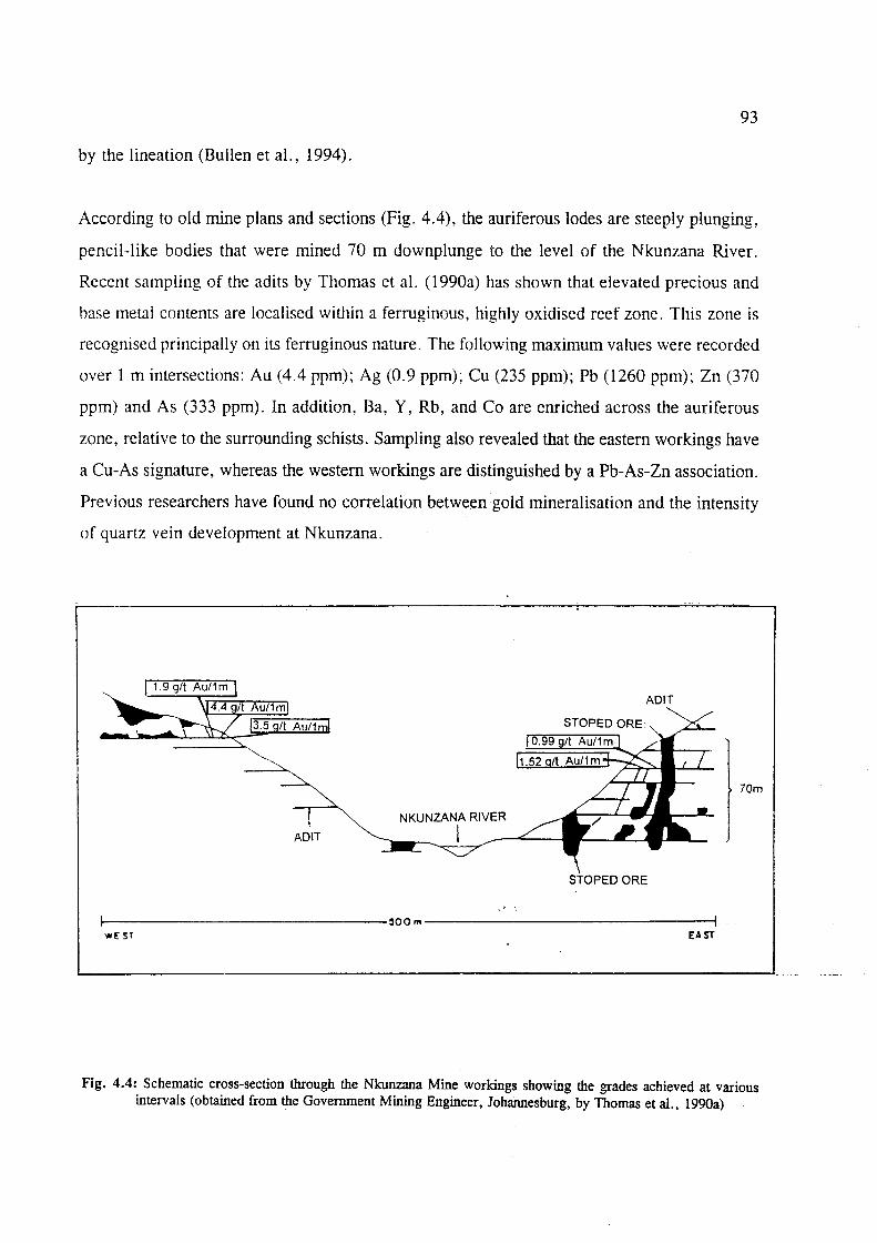
93
by the lineation (Bullen et al., 1994).
According to old mine plans and sections (Fig. 4.4), the auriferous lodes are steeply plunging,
pencil-like bodies that were mined 70 m downplunge to the level of the Nkunzana River.
Recent sampling of the adits by Thomas et al. (l990a) has shown that elevated precious and
base metal contents are localised within a ferruginous, highly oxidised reef zone. This zone is
recognised principally on its ferruginous nature. The following maximum values were recorded
over 1 m intersections: Au (4.4 ppm); Ag (0.9 ppm); Cu (235 ppm); Pb (1260 ppm); Zn (370
ppm) and As (333 ppm). In addition, Ba, Y, Rb, and Co are enriched across the auriferous
zone, relative to the surrounding schists. Sampling also revealed that the eastern workings have
a Cu-As signature, whereas the western workings are distinguished by a Pb-As-Zn association.
Previous researchers have found no correlation between gold mineralisation and the intensity
of quartz vein development at Nkunzana.
AD IT
STOPED ORE
70m
NKUNZANA RIVER
AD IT I
~----------------------------~OOm----------------------------~ we: Sf EAST
Fig. 4.4: Schematic cross-section through the Nkunzana Mine workings showing the grades achieved at various intervals (obtained from the Government Mining Engineer, Johannesburg, by Thomas et al., 1990a)

94
NAPPE ZONE
4.1.1.4. Phoenix Mine (Tugela Nappe)
This mine is located in the extremely inaccessible "Umvoti Goldfield" which is situated on the
Tugela River, some 12 km east-southeast of Ngubevu (Fig. 4.2) on Reserve No.19 7638. Old
workings consisted of 4 adits driven into a hillside, where 90 tons of ore were milled in 1907
at an average grade of 8.4 glt (Hatch, 1910). Mineralisation is hosted within a west-striking
shear zone which is about 3 m wide. The shear zone occurs in medium-grained actinolite
clinozoisite-sericite metagabbro of the Tugela Group and dips at 65 0 S. A grade of 5.49 glt
gold over 60 cm, along a 50 m strike length, and patches of high grade mineralisation were
reported by Hatch (1910). Significant gold mineralisation is confmed to relatively undeformed
quartz veins (up to 75 cm thick) within this shear zone, where the metagabbro is retrogressed
to a chlorite-biotite schist.
Theart (1987) recommended a detailed exploration programme in this area to locate possible
extensions to the known mineralisation. The best grade obtained was from a pyrite-bearing
quartz vein, which gave a value of 6 glt over a width of 70 cm. Although recent investigations
have revealed good grades in places, the workings have remained abandoned.
4.1.1.5. Mpapala Goldfield (Madidima Nappe)
This goldfield is situated about 22 km west of Eshowe in the "Mbongolwana Flats" (Fig. 4.2)
on Reserve No.21 7638. Four old workings (Rebellion Reef, New Year, Havilah and Cooper's
Shaft) have been worked here in the early 1900's (Table 4.2).
The gold occurs disseminated in quartz veins in amphibolites of the Silambo Formation of the
Tugela Group and in a later, sheared aplitic dyke. Schurink (1986) reported anomalously high
Au, Ag, Cu, Pb and As values. The quartz veins lie within narrow shear zones, one of which
is continuous from the Rebellion to the New Year workings, a distance of over 2 kms. Thomas
et al. (1990a) concluded that the Au in the Mpapala Goldfield is clearly of hydrothermal,
epigenetic origin, similar to that at Ngubevu. Evans (1988) considered the potential for finding
mineralisation at depth in the area to be very promising, as all the old workings were
discovered because they outcropped or occurred near the surface. His recent sampling of some
of the old workings indicated encouraging results (Table 4.2). However, detailed geological

95
studies (mapping, trenching, geochemistry, geophysics, magnetic survey, resistivity and
drilling) by Schurink (1986) on the old Rebellion Reef Mine revealed that the quartz veins have
limited strike lengths and pinch out with depth. Diamond drilling and trenching revealed K
metasomatism and epidotization as dominant alteration patterns, with traces of calcite and
chlorite also evident. Pyrite and magnetite were evident in most samples, with minor
chalcopyrite. In addition to these workings, Thomas et al. (1990a) reported a new occurrence
in the area (Fig.4.2), with a grab sample grading at > 9 g/t. No further work is reported to
have been done in the area.
Table 4.2: Characteristics of the Mpapala Goldfield Workings
Working Tons Grade Known Extent of Maximum Crushed (g/t) Orebody Width of
Orebody
Rebellion 508 1.7 16.8 m strike; 1.7 m 15.9 m depth
Havilah 189 6.9 Strike unknown; 1.5 m 19.8 m depth
New Year 436 5.2 Strike unknown; 5.5 m 11.0 m depth
Cooper's 1 40.5 450 m strike; 2.0m Shaft 7.6 m depth
Data from Thomas et al. (l990a) and Evans (1988).
4.1.2. Gold-bearing Massive to Semi-massive Sulphides
4.1.2.1. i'Thuma Volcanogenic Sulphide Deposit
Orientation of Ore body
045/80 SE
037/vertical
037/vertical
045/85 SE
Recent grab sample Assay (Evans, 1988)
4.5 g/t Au; 580 ppm Cu; 58 ppm Zn
N/a
3.2 g/t Au: 4140 ppm Cu; 5100 ppm Pb
N/a
Stratiform, sulphide-rich volcanogenic rocks were discovered in the i'Thuma River area
(Figs.4.2 and 4.5) in the early 1980's on Reserve No.19 7638. According to Thomas et al.
(1990a), the orebody consists of a - 2m thick, fuchsitic, ferruginous, sulphide-rich unit with
sheared margins in Tugela Group host rocks. Mineralisation is associated with two litholegies:
1) amphibolitic metalavas and 2) pelitic/psammitic metasediments. The orebody has been
folded into a major, northeast-plunging, tight-to-isoclinal Fl antiform, with both limbs dipping
northwest at about 40°. Shearing is most intense at the sulphide/host-rock interface due to the
competency contrast, with the intensity of shearing decreasing towards the core ef the sulphide
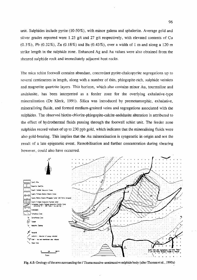
96
unit. Sulphides include pyrite (10-50%), with minor galena and sphalerite. Average gold and
silver grades reported were 1.25 glt and 27 glt respectively, with elevated contents of eu
(0.3%), Pb (0.32%), Zn (0.18%) and Ba (0.43%), over a width of 1 m and along a 120 m
strike length in the sulphide zone. Enhanced Ag and Au values were also obtained from the
sheared sulphide rock and immediately adjacent host rocks.
The mica schist footwall contains abundant. concordant pyrite-chalcopyrite segregations up to
several centimetres in length, along with a number of thin, phlogopite-rich, sulphide veinlets
and magnetite quartzite layers. This horizon, which also contains minor Au, tourmaline and
andalusite, has been interpreted as a feeder zone for the overlying exhalative-type
mineralisation (De Klerk, 1991). Silica was introduced by premetamorphic, exhalative,
mineralizing fluids, and formed medium-grained veins and segregations associated with the
sulphides. The observed biotite-chlorite-phlogopite-calcite-andalusite alteration is attributed to
the effect of hydrothermal fluids passing through the footwall schist unit. The feeder zone
sulphides record values of up to 230 ppb gold, which indicates that the mineralising fluids were
also gold-bearing. This implies that the Au mineralisation is syngenetic in origin and not the
result of a late epigenetic event. Remobilisation and further concentration during shearing
however, could also have occurred.
;t .<!"'''' / .It'Itrl'7'T'! - ~'''" "t pIunqt >n6tattd
,~ fd. - 110 ~ ~~ 5Idt !rtticoted
',- _z,...
Scale
. Ib!rtz 'I ....... ~ '"'" f7'1t __ ••
. (lan) .... ~~.~to!~.
C- .... :\. • .. .. , .. :.
Fig. 4.5: Geology of the area surrounding the i'Thuma massive-semimassive sulphide body (after Thomas et at., 1990a)

97
Thomas et al. (1990a) related the i' Thuma deposit to other volcanogenic massive sulphide
deposits (e.g. the Australian deposits described by Large et aI., (1989», based on paragenetic
associations, where the Pb-Zn-Ag-Au association occurs in the massive to semi-massive
sulphide body, with a footwall stringer zone consisting of pyrite and chalcopyrite only. These
authors therefore proposed that the i'Thuma River mineralisation represents an example of a
syngenetic, sediment-hosted, volcanogenic, submarine exhalative, auriferous massive sulphide
deposit, the first of its kind to be recognised in the NMP. The marginal grades and lack of
infrastructure have thus far counted against the economic viability of this deposit.
4.1.3. Base Metal and other Mineralisation
4.1.3.1. Ngubevu Cu-Zn Mineralisation
Several shear zone-hosted Cu-Zn showings were identified 6 km east of the Ngubevu Goldfield
(Figs. 4.2 and 4.3), hosted in deformed, southerly dipping, quartz-mica schists and chlorite
epidote schists with quartz-calcite veins containing coarse-grained pyrite. Brown (1988a) noted
relic textures in the rocks and suggested that the Mfongosi schists at this locality could
represent highly deformed metalavas and tuffs and that the mineralisation was of submarine
volcanogenic exhalative type, with a chloritised and carbonatised stringer zone to the south,
and a stratigraphically higher, Cu-Zn sulphide zone to the north. Sampling of gossanous
outcrops indicated grades of up to 0.85% Cu and 1 % Zn (Thomas et aI., 1990a).
4.1.3.2. Mfongosi Pb-Ag Workings
These workings, reported to be situated 2 km north of the Mfongosi gold mine (Fig. 4.2), could
not be located by Thomas et al. (1990a). Mfongosi chlorite schists host the mineralisation
which is associated with a 1.7 m thick south-dipping quartz vein in a shear zone.
The ore body appears to be zoned, with Cu sulphides concentrated towards the hanging wall
and pyrrhotite towards the footwall. However argentiferous galena was disseminated
throughout (Hedges, 1909).
4.1.3.3. Mfongosi Cu-Ag Occurrence
This occurrence is situated 1 kIn northwest of the confluence of the Mfongosi and Tugela
Rivers (Fig. 4.2). Deformed mineralised granitoid in the form of concordant lenses (up to 5
m wide and 3 m thick) intrude the chlorite schists, magnetite quartzites and limestones of the

98
Mfongosi Group. Grab samples analyzed from these extremely sodic granitoids revealed values
of up to 1.6% Cu and 9 ppm Ag (Thomas et aI., 1990a). The mineralisation here is thought
to be related to the intrusion of cupriferous sodic granite veins and dykes.
4.1.3.4. Magmatic Ores
A number of east-west trending ultramafic bodies occur in the nappe zone of the Tugela
Terrane (Figs. 4.2 and 4.6), of which only the Sithilo Complex, Tugela Rand Complex and
Ntulwane serpentinite body appear to have been explored. The latter two deposits did not
encourage further investigation after initial analyses indicated low Cr20 3 values and low Cr/Fe
ratios (Wuth and Archer, 1986). The most relevant deposits will be described below.
LEGEND
~::::EMASUlFI'C~1 'A~N"O<>' ..... AFIC
- GRANITIC AND .. ,G ...... TITIC ,,\ GNEISSES AND AMPI~BOL.lTES'n ::::: UOIOIFFEI'£NTIATEO ;;-" IIIETA.IOOI!PHIC ROCKS
.. AJOR THIlUST FAULTS
8 o ,
KILOMETRES
• GREYro.,,,
• PIETER ... ""rZ8URG
(Adapted after Matthews, 19~9, 1981)
Fig.4.6: Geological setting of the ultramafic bodies within the Tugela Terrane (after Wuth and Archer, 1986).
4.1.3.4.1. Sithilo Complex: Chrome
The Sithilo Complex, which consists essentially of serpentinised dunite, is located on Reserve
No.21 7638, some 27 km west of Eshowe, where it intrudes amphibolites of the Tugela Group.
It is one of the larger ultramafic bodies in the area, with a strike length of approximately 3 km

99
and width varying from 0.5 to 1 kIn. According to early Mining Reports on the Natal Colony,
attention was first focused on this deposit in 1904 because of the discovery of good quality
chrysotile asbestos veins. However, it was only in the early 1950' s that exploration at Sithilo
revealed four, low-alumina chromite orebodies and during 1952-53 approximately 2000 tons
of high-grade chromitite concentrates were produced from four adits driven into the
northeastern flank: of Sithilo Hill (Wuth and Archer, 1986).
The bulk of the Sithilo body is made up of dunite and olivine peridotite which have locally
developed primary cumulate textures. Much of the economically exploited chromite
mineralisation is hosted in dunite. Chromite occurs as numerous isolated pods, stringers and
irregular stockworks, or may be disseminated. In three of the old workings the chromitite
occurs as lenticular bodies, whereas the fourth working is a 15 m diameter, SE-pitching pipe
like chromitite body. The present setting of the chromite lenses is due to tectonic influence,
as they are aligned en echelon and parallel to shears. Initial concentration however, was
attributed to primary magmatic differentiation within the oceanic crust which initially localised
and concentrated the mineralisation. Later faulting further limited the extent of the chromite
orebodies.
Wuth and Archer (1986) found that in terms of lithology, structure and tectonic setting, the
Sithilo body shows affInities with the ultramafic portions of typical chromite-bearing, alpine
type ultramafic complexes around the world, even though it has an incomplete ophiolite
sequence (i.e. in the absence of pillow basalts, sheeted dykes and upper gabbros). In addition
the textural and compositional character of the chromite is considered suffIcient evidence to
classify the mineralisation at Sithilo as a Precambrian equivalent of the considerably younger,
alpine-type ophiolitic podiform chromite deposits such a~ ,tbose found in Turkey, Cyprus and
the Phillippines.
Comparison of ore grades from Sithilo with other alpine-type -deposits shows a close
correspondence, apart from the lower alumina contents (less than 5% A120 3) atSithilo. Grades
within the four workings range from 9 to 50% Cr20 3 while CriPe ratios are typically 1 in the
lower grade ores, up to 3.3 in the highest grade ores. Between 1977 and 1979 the deposit was
intensely explored by ETC Mines Limited. However, no work has been reported since.

100
4.1.3.4.2. The Tugela Rand Layered Suite: Chrome
This suite is located on the fann Tugela Rand 1974, somelO Ian north of Kranskop and fonns
a well-layered association of mafic and ultramafic rocks which intrude the amphibolitic
gneisses of the Tugela Nappe (Figs. 4.2 and 4.6). According to Wilson (1990), the Tugela
Rand Layered Suite fonned as a result of repeated, and sometimes continuous, emplacement
of magma into a chamber which at the same time was undergoing crystallisation, while
subsequent defonnation altered the original sheet-like fonn of the intrusion. The defonnation
caused layering in the northern part of the body to have a shallow dip towards the south, while
the southern part of the intrusion is more vertical and overturned (Eales et al., 1988).
Chromite occurs as impersistent layers associated with wehr lites and serpentinites and varies
from massive chromite to disseminated layers. These irregular chromite orebodies were of
limited size and too low grade to warrant exploitation. Thomas et al. (1990a) reported
disseminated Cu, Ni and Co sulphides within the lowennost pyroxenitic and peridotitic rocks
of the suite. Peak values of 0.12% Cu, 0.25% Ni and 0.027% Co over 3.1 m were obtained
from diamond drilling in the northeastern part of the complex (Versfeld, 1981).
4.1.3.4.3. Sebenzani Cu-Ni Sulphides
An aerial magnetic anomaly and the occurrence of gossans in the Sebenzani area , some 8 km
west of Empangeni, led to an intensive exploration programme for mineralisation here (Schutte
and Schurink, 1986). The occurrence is situated south of the Natal Thrust Front, in the Nkomo
Nappe (Fig.4.2), in amphibolites, talc schists and actinolite schists with intrusive gabbros and
serpentinites. Sulphide minerals include pyrrhotite, pyrite and chalcopyrite.
Drilling of anomalous areas revealed sulphide intersections in all boreholes, with the following
maximum values recorded over 5 m: Cu (0.6%), Ni (0.8%) and Co (1149 ppm). In addition,
Schutte and Schurink (1986) noted that platinum group metals occur in association with the
sulphides. Knoetze (1988, cited in Thomas et aI., 1990a) suggested that this occurrence was· .
also an ophiolite-type deposit, similar to the Sithilo body. They· considered the potential for
economic Cu-Ni mineralisation as excellent and further exploration in the area was
encouraged.

101
4.1.3.4.4. Mambula Complex: Iron, Titanium and Vanadium
The Mambula layered mafic complex, on Tugela Location 4674, outcrops over an area of 25
km2 some 20 km east of Kranskop (Fig. 4.2), near the confluence of the Tugela and Mambula
Rivers. These titaniferous iron ores were first recognised and described by Du Toit (1918) and
later by Wagner (1928).
The Mambula Complex intrudes amphibolites of the Tugela Group. A broad saucer or funnel
like shape is envisaged for the body due to radially dipping contacts of the layering (Schulze
Hulbe, 1979). The complex is made up of medium-grained gabbro with lesser amounts of
norite, websterite, anorthosite and vanadium-rich titaniferous magnetite layers. At least six
magnetite-rich layers from 1 to 5 m in thickness are recognised. Poor exposures however,
prevent estimates of their extent or lateral continuity. These ores consist of up to 90 % V -Ti
magnetite, ilmenite and pleonaste, with trace amounts of the sulphides pyrrhotite, pentlandite,
cubanite, chalcopyrite and pyrite also recorded. Ore reserves, estimated by Luyt (1976), are
thought to be in the region of 22 Mt at an average grade of 45.92 % Fe, 11.53 % Ti02 and
0.56% V20 5. According to a detailed mineralogical assessment by Reynolds (1986), it was
found that due to the relatively coarse grain size of the ores, the presence of abundant granular
ilmenite and simple grain boundary relationships, the ores will be amenable to beneficiation.
This would yield an ilmenite concentrate (50.4 to 53 % Ti02) and a Ti-poor magnetite
concentrate (3 - 8 % Ti02) containing approximately 1.1 % V 205' The ores were found to be
rarely pure and generally contain between 10 and 30 volume % of silicate minerals, largely
plagioclase and clinopyroxene with lesser amounts of hypersthene.
According to Reynolds (1986), the ores formed during the later stages of the fractional
crystallisation sequence responsible for the formation o!,the complex. The more felsic and Fe
rich nature of this complex suggests that it represents a stratigraphically higher level of a
layered complex than the Tugela Rand Layered Suite (TRLS). Like the TRLS, the Mambula
Complex was also affected by the tectonics and metamorphism during the NMP tectonic event.
The complex was subject to amphibolite facies metamorphism (which modified the texture of
the Fe-Ti oxide ores) and northward-directed thrusting.

102
The economic potential of the deposit is considered to be limited due to its remote locality,
small size and moderately low TiO:! and V20 5 contents. In addition, vast resources of these
commodities occur in the Bushveld Complex, which can more economically supply the
requirements of these commodities in the foreseeable future. Latest exploration attempts here
concentrated on Ni and PGM mineralisation, especially after investigations by STK
(Steenekamp, 1990) revealed a potentially mineralised troctolite unit in the northern part of the
Complex. However, reconnaissance exploration (Anglo American Report, 1992) indicated no
significant base or precious metal mineralisation and all prospecting here was abandoned.
4.1.4. Alkaline Complexes
The Wangu, Ngoye and Bull's Run alkaline/peralkaline gneiss occurrences near the
northeastern margin of the NMP (Fig.4.2) constitute the remnants of a tectonised and
metamorphosed alkaline magmatic province. Subeconomic quantities of the various elements
typically associated with alkaline and A-type granite complexes were noted at each of these
localities (Scogings, 1989a). The potential mineralisation in these bodies was investigated by
Scogings (1983, 1986, 1988a, 1989a) and Scogings and Forster (1989). Exploitation potential
for these deposits currently appear to be poor. Refer to Chapter Two for lithological
descriptions.
4.1.4.1. Wangu Granitoid Gneiss
Scogings (1989a) suggests that the Wangu gneisses represent deformed A-type peralkaline
micro granitic or aplitic rocks. These rocks outcrop in the Wangu Hills area, northwest of
Eshowe. Analyses of these gneisses have shown marked enrichment in incompatible and large
ion lithophilic elements such as Zn, Nb, Zr, Th, Y and Rb (Scogings, 1988a). Of particular
economic interest were samples which showed high concentrations of Nb (614 ppm), Y (514
ppm) and REE (2300 ppm). No discrete REE minerals occur in these rocks, and it was
therefore suggested that the incompatible elements may be hosted by sodic minerals such as
aegerine-augite (Scogings, 1989a).
The anomalous REE, Zr, Nb and Zn contents in the localised iron-rich highly peralkaline
siliceous gneisses within the Wangu gneisses were interpreted by Scogings (1989a) as
magmatically concentrated cumulate layers.

103
4.1.4.2. Bull's Run Complex
The Bull's Run Estate 12987 is a farm situated on the north bank of the Mhlatuze River some
24 km north of Eshowe. This Complex is essentially composed of syenite and nepheline-syenite
gneisses with minor intrusive phases of carbonatite and peralkaline microsyenite (Scogings and
Forster, 1989). These intrusive phases of carbonatite contain, apart from apatite, calcite and
biotite, accessory phases such as ilmenite, pyrite, pyrochlore and zircon. Samples of brown
carbonate gneisses revealed values of up to 3993 ppm Nb and highly elevated Y, Sr and Ba
values. Eluvial and alluvial occurrences of zircon, ilmenite and monazite were also reported
by Von Backstrom (1962) for this body and are described in Table 4.5.
4.1.4.3. Ngoye Complex
The Ngoye Complex is an elongate east-west trending body approximately 25 km long and up
to 4 km wide located just south of Empangeni (Figs. 4.2 and 4.7). The body is surrounded by
felsic and amphibolitic gneisses of the NMP. The southern contact of the N goye granite gneiss
and surrounding gneissic terrain were found to have potential for Nb, Ta, Sn, W and D
mineralisation during an investigation of aeromagnetic and air-radiometric anomalies by the
South African Development Trust Corporation (STK) (Scogings, 1983). Magnetite-rich rocks
adjacent to the southern margin of the Ngoye body showing these anomalies were sampled and
found to have high Nb, D, Th, Y, Zr and rare earths with minor Sn, W and Ta values. A
mafic intrusive body also near the southern contact (Fig.4.7) showed very high magnetic
values. Targets were delineated using geophysics, soil and rock sampling and trenching to
locate sites for drilling.
The target over the mafic body was shown to have high Ni content in soil and rock samples.
Pyrrhotite, chalcopyrite and possibly pentlandite were. ,macroscopically identified. Drilling
revealed mineralisation restricted to the marginal and contact zones along the southern part of
the Ngoye Complex. Magnetite-bearing pegmatites also along the southern contact were-found
to have elevated concentrations of Sn, W, Ta, Nb and D. However; the mineralised horizons
are erratic both in grade and width, as well as having short strike lengths. Widths are generally
less than 3 m, averaging 1 m. The two elements with the most consistent high concentrations
here are Nb and D30 S' Reserves were calculated at 1 158 tonnes per metre depth over a 90 m
strike length. Average grades calculated by Scogings (1983) are shown in Table 4.3.

104
Table 4.3: Mineralisation grades in the southern part of the Ngoye Complex
Element Sn W Ta Nb U30 S
Grade 13 ppm 60 ppm 46 ppm 1253 ppm 109 ppm
It was concluded that due to the complex nature of the mineralisation and low market values
for the elements with high concentrations, this mineralisation was currently unlikely to have
any mining potential. Also, there are abundant reserves of these elements elsewhere in the
world to sustain supplies for the foreseeable future.
PHANEROZOIC
- 28'50'
,..:t . . :.;".
II1II Peraluminous Granitoids
N Metaluminous Granitoids
o Peralkaline Granitoids
~&::ggY;H:l Rocks of the NMP
BIOTITE GRANITE GARNE T -MUS(OVITE APlITI( GRANITE ,.,,- --= -
• • •
, k,.
--.... SC""AL=='E==
N
<P
Fig.4.7: Geological Map of the Ngoye Complex showing sample localities (after Bullen et al.. 1992)

105
4. 1.5. Industrial Mineral Deposits
4.1.5.1. Bull's Run Complex Mineral Fluxes
Germiquet (l986a) recognised the Bull's Run Complex (Fig. 4.8) as a possible source of
nepheline-based mineral fluxes for use in various industrial applications. Nepheline syenite is
a nepheline-feldspar combination widely used as a source of alumina and alkalis for the
manufacture of glass and ceramics, as well as for fillers/extenders in the paint, plastics, rubber
and adhesive industries. Exploration and beneficiation tests were undertaken by the South
African Development Trust Corporation (STK) on the Bull' s Run Complex syenites in the late
1980's (Scogings, 1989b). Results indicated the presence of low-iron, glass-grade, nepheline
syenite products equivalent to those produced in Canada, Norway and France. Comparisons
with commercial nepheline syenite products from these countries are shown in Table 4.4, with
sample localities from Bull's Run shown in Fig 4.8.
Preliminary cost studies by Germiquet (1986b) indicated that the venture would be
economically viable if product quality is acceptable to the local glass and ceramics industries
and if sales of 2000 t/month were achieved.
Table 4.4: Comparison of Bulls Run mineral fluxes with those currently exploited overseas
I I D400 D402 D403 B213 A450 Norway Canada France
SiO, 62.40 56.80 55.71 55.70 59.34 55.70 60.30 59.80
Al,O>- 20.00 23.56 23.45 21.30 23.06 23.90 23.70 20.65
Feo01 0.12 0.12 0.08 0.32 0.12 0.12 0.07 2.08
CaO ----- ----- ----- 3.55 0.22 1.23 0.30 -----
Na20 4.46 9.12 8.69 8.90 8.45 8.20 10.40 8.50
K,O 10.80 7.54 7.25 5.39 7.75 8.57 5.00 6.25
Data from tables in Scogings (1989b). French sample is a beneficiated phonolite product. ----; Data not determined
The nepheline syenite crops out mainly on the farm Bull' s Run Estate and access to the
outcrops here is poor. However, initial developers have targeted work on one of the several- .
smaller pluglike nepheline syenite bodies at the more accessible eastern end of the Complex.
Potential reserves to a depth of 50 m were considered promising. Development of this site with
respect to mining had been hampered due to the fact that this area was to be proclaimed a
nature reserve.
}. , , , 'I ( • , ""'-"1".-": -BULL'! RUN COMPLEX
30 S .... 4., '----:: 'at.\- OU"B.f.N "'OUA. H", ...
CAPE TOWH"'----
2 E 9'-______ "90 K~
o 2 3 Km
106
, • +-
\ {D ALBITE SYENITE GNEISS
BULL'S r--, NEPHELINE SYENITE GNEISS RUN L--J COMPLEX ~.'.' L:..-.:..J MUSCOVITE SYENITE GNEISS
D TUGELA AND MFONGOSI GROUP
o KAAPVAAL CRATON
~ NATAL THRUST FRONT
BENEFICIATED SyENITE AND ~ 0403 WHOLE ROCK ANALYSIS
Fig. 4.8: Geology of the Bull's Run Complex showing localities for samples analyzed in Table 4.4 (after Bullen et aI., 1992).
4.1.5.2. Ngoye Complex (Quartz and feldspar aggregates fo~,the glass industry)
An elongate, intrusive sheet-like outcrop of peraluminous, gamet-muscovite aplitic granite on
the northern flank of the Ngoye Complex (Fig. 4.7) on Reserve No.9 7638, was suggested as
suitable raw material of low-iron, non-magnetic quartz and feldspar aggregates for the glass
industry (Scogings, 1989c). Beneficiation tests conducted by Mintek on two bulk samples of
fresh material returned favourable results, with low Fe20 3 values important for the glass
industry. On the basis of these initial beneficiation results, a more detailed prospecting
programme to delineate reserves of suitable material was recommended.

107
4.1. 5.3. Potentially exploitable and Minor Deposits
These deposits, described below and in Table 4.5, are other industrial mineral deposits of
the Tugela Terrane (Fig. 4.9). Some of these have been worked in the past, while the others
have uncertain potential and require further investigation. The only currently working deposit
is a stone aggregate quarry.
• 31'00'
I
KAAPVAAL CRATON tlTIIIG'.IE OOLOHITE
eULL'S RUN COHPLEX
Eshow ••
o working Mme
o Abandoned Mine
o Occurrence
PHANEROZOIC COVER
, i
A( - (hrysotile Asbestos
F - Feldspar Q - Quartz S - Serpentinite
ST - stone Aggregate
Fig. 4.9: Map of the Tugela Terrane showing industrial mineral occurrences, with talc occurrences shown in black (after Bullen et aI., 1992).
Talc
Extensive talc schist occurrences were first reported in the Tugela Valley by Du Toit (1931).
More recent investigations by STK (Scogings, 1988b; Van Rensburg and Ahrens, 1989)
delineated five potentially exploitable talc bodies in the eastern part of the Tugela Valley in
the Middledrift-SitiIo-Khomo area, some 35 km west of Eshowe (Fig.4.9).
Ultramafic igneous intrusives, emplaced as sheets and pods along the soles of thrust planes
in the Nappe Zone (Matthews, 1981) were altered to produce the talc bodies. Alteration was
attributed to hydration due to retrograde metamorphism. According to BulIen·et al. (1992),
XRD analysis revealed that the predominant minerals are talc, chlorite and anthophyllite,
which led them to propose the following reaction for the formation of the taIc:
Olivine + orthopyroxene + H20 - talc + chlorite ± anthophyllite
-28'46'

108
Percussion drilling and pitting by STK (Van Rensburg and Ahrens, 1989) indicated that the
shape of the talc bodies were highly irregular and discontinuous. Furthermore, the talc is
generally off-white and no significant high-grade deposits were found in the area under
investigation. The deposits may have future potential though, as samples of the talc proved
amenable to a new beneficiation process developed for kaolin deposits by Minemet Industrial
Minerals (Bullen et al., 1992).
Table 4.5: Potentially Exploitable and Minor Deposits within the Tugela Terrane
Commodity Locality Nature of Host Rocks References Potential (Fig 4.9) Mineralisation Reserves/uses
and Comments
Dolomite Outcrops north Average Chlorite schist Bullen et al Reserves> of Tugela River CaC03 = 50.7%, (1992); 100 Mt between the MgC03 = 37.3%, Mackie (estimated) Buffalo and Si02 = 9% (1986); Suited for Mfongosi Rivers Martini agricultural
(1987) lime only because of high magnesia content
Silica i'Thuma River 35 m diameter sub- Mfongosi Group Bullen et al. High purity area circular quartz 'blow' , schists and (1992) silica of
localised faint iron gneisses potential staining electronics
--------------- ---------------------- ---------------- quality 1.5 km SSW of 400 m long outcrop of Mfongosi Group old Nkunzana 1m thick quartz veins schists and Gold Mine gneisses
Chrysotile Sithilo (Tugela 12 to 24 asbestos veins, Veins occur Bullen et al. Previously Asbestos Valley) of 120 mm total adjacent to a (1992) mined (opencast
thickness. Fibre lengths micro granite and between 6-12 mm dyke underground)
Tugela Rand asbestos veins with veins developed Poor quality as (Tugela Valley) fibre lengths 3-18 mm adjacent to fibres brittle
micro granite sills
-Zircon Bull's Run Eluvial and alluvial In decomposed Von Grades of up to
Complex zircon deposits. gneisses Backstrom 0.66% Crystals up to 6 em (1962); combined long Scogings & ilmenite, zircon
Forster and pyrochlore Jl282) in 1!luvial. soil_
Stone Ngoye Complex Medium-grained N goye Complex Bullen et al, Aggregate Aggregate biotite-rich gneissic granite-gneiss (1992) production for
granites local concrete - - industry
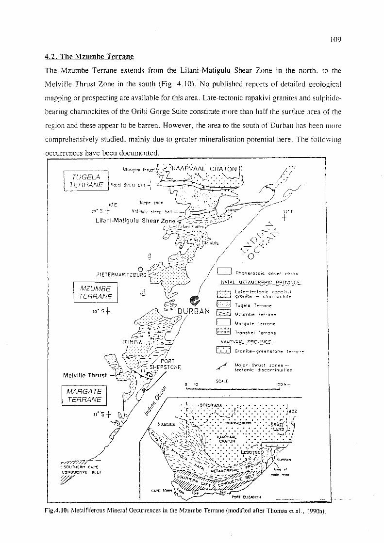
109
4.2. The Mzumbe Terrane
The Mzumbe Terrane extends from the Lilani-Matigulu Shear Zone in the north. to the
Melville Thrust Zone in the south (Fig. 4.10). No published reports of detailed geological
mapping or prospecting are available for this area. Late-tectonic rapakivi granites and sulphide
bearing charnockites of the Oribi Gorge Suite constitute more than half the surface area of the
region and these appear to be barren. However. the area to the south of Durban has been more
comprehensively studied, mainly due to greater mineralisation potential here. The follo\ving
occurrences have been documented.
f7.7l ~
EJ t--=-:;;J o ~ E3
SOcE:
Phanerozoic cover rock!;
lo~e-tecton;c rcC'ck!\i gronite - chornockit~
Tuge10 r.--rOCle
Terrone
Tronskei Terrane
Granite- greenstone
~~ajor thrust zonestectonic discontinuities
o 10 100 ,~ ~I ________________________ -JI
po,,' rUW~H
rigA.IO: Metalliferous Mineral Occurrences in the Mrurnbe Terrane (modified after Thomas et ;11.. 1990;1).

110
4.2.1. Umzinto Goldfield - Shear Zone-Hosted Gold
These gold deposits are situated in the southern part of the Mzumbe Terrane, to the west of
Scottburgh, on the south coast of KwaZulu-Natal. Gold was discovered in auriferous reefs in
gneisses near Dumisa Station, in 1887. By 1888, 16 gold prospects had been established in the
area (Fig.4.11), some of which became small mines. The bulk of the production came from
Dumisa itself. Unsuccessful attempts were made to reopen the Dumisa gold mine in 1987,
after a revival of interest in gold following the record gold prices of 1980.
The goldfield was divided into two sectors (Thomas and Gain, 1989), constituting the western
or Dumisa sector, and an eastern, Inyangaleza sector. Most recent work was carried out in the
western sector, as many of the workings in the Inyangaleza sector are now incorporated into
the Vernon Crookes Nature Reserve. The host rocks of the mineralisation in the western sector
are highly sheared, leucocratic, syntectonic granite gneisses of the Mzimlilo Suite and fine
grained pink, acid gneisses, of the Ndonyane Formation, a sequence of deformed and
metamorphosed acid volcanic and volcaniclastic rocks. The mineralisation in the eastern sector,
where ten of the workings were located, is predominantly hosted in the Mzimlilo granites and
banded gneisses of the Quha Formation. In all the Urnzinto occurrences, the gold, though
erratic in grade, appears to have been either disseminated in the sheared host rocks, or locally
concentrated in later en echelon sulphide-rich quartz vein arrays (Thomas et al., 1990a), the
latter containing silver and elevated base metal values (Bullen et aI., 1994). Tables 4.6A and
4.6B from Thomas and Gain (1989) summarise details of most of the workings in the Urnzinto
Goldfield.
Detailed geological and mineralogical analyses were carried out at both the Dumisa and
Alfreda Mines (Thomas and Gain, 1989). At Dumis_a, gold mineralisation was found
sporadically throughout foliations in the shear zones but was generally enriched within, and
proximal to, the quartz veins. Some secondary gold enrichment in later brittle, iron-stained
fractures may have occurred close to the surface. A mineralogical examination of the ore
indicated pyrite as the dominant sulphide, with less abundant cobaltite, marcasite, chalcopyrite,
pyrrhotite, molybdenite and covellite. Microscopically, much of the gold is dispersed along
silicate and pyrite grain boundaries and fractures. Sampling over a 2 m width revealed grades
of up to 6 glt Au, though the average grades were somewhat lower.

111
Table 4.6A: Characteristics of the Dwnisa Sector Workings (after Thomas and Gain, 1989)
Mine/Prospect Mineralisation Type of Workings Minim i om Est. Comments & Production Recorded grade Period Yield iglt)
Dumisa (1888- Gold occurs with Shafts to 30 m depth. 10.42 kg 13.0 More 1889) sulphides in en echelon Main adit is a drive 100 production may
mm to cm-scale veins m along strike have occurred associated with intense fabric dipping 45-55°S.
1903-1914 Mineralised zone is 9- Further 300 m of driving 31.60 kg 12.3 Figures only up 10 m wide and extends and shaft sinking. Main to 1909 for 10' s of metres along ad it extended to 160 m strike with a 12 m cross-cut
Alfreda (1889) Ferruginous quartz vein 2 adits, a winze and 0.15 kg 4.7 Figures from arrays and stringers in numerous trenches over a 49.7 trial crushing. silicified zone of 400 m strike length Production intense, shallow- figures not dipping shear fabric available.
Mimosa (1892) 10-100 mm-wide quartz 3 shafts to 40 m depth, 1.28 kg 10.3 Yield and veins dipping 45°. Gold drives at 18 m level. grades are associated with silver. Inclined shaft to 30 m. minimum
values
Other Prospects Gold-bearing quartz Trenches and adits N/A N/A No records of veins and stringers with production in sulphides. Veins dip the literature southwards.
Table 4.6B: Characteristics of the Inyangaleza Sector Workings (after Thomas and Gain,
1989)
Mine/Prospect Mineralisation Type of Workings Minimum Est. Comments recorded grade yield (g/t)
Happy Thought Pyrite, pyrrhotite and A number of adits and ± 15.5 kg 8.8 Grades up to (Evans, 1984) Au in quartz vein arrays four vertical shafts up to 15.5 g/t
in N-trending banded 56 m depth gneiss
Golden Associated with blebs of Single vertical shaft 93 grams 14.0 Grade from Butterfly pyrite within a quartz quartz blow
vein hosted in granite. - on which the High values localised to shaft was sunk a 1.5 m wide quartz blow ----~- ---~----~ -- --
Other Prospects Quartz arrays up to 1m Adits and shafts, trenches ± 3.5 kg ± 8.0 Most deposits width, 70 m strike now occur in length, dip steeply to a nature the west. Mineralisation resel'Ve associated with sulphides .-_.-- --~--- be

----- -
30 0 30' Pududu
UMZINTO GOLDFIELD
.9 .8
/' ·11 -'-
.16 12·", .13
·14-.
112
t DUMISA SECTOR Scottburgh
MINES AND PROSPECTS , , Umzlnto
• U nna med
\J~~ ~: 2 U P Syndicate
3 Phoenix I NY AN GALEZA SECTOR
4 Pluto MI NE S AND PROSPECTS
5 Hall's 11 Col e
6 Oumisa 12 Golden Butterfly
7 Knox 13 Ha ppy ThouQht
8 Alfredo 14. Guy Fowkes
9, A I ken 15 Crocker's Reef
10 Mimosa 16. Cedarville
TRANSVAAL
/ " . I ,\"_._-_.":,:.':7
I o F S. i NATAl--. '" ..... KWAZULU
N
o IOkm CAPE - TRANSK EI
of maIn map
• __ ~=--==--=~ ____ ~~~i Hlbberdene SCALE 2~OOCC
Fig. 4.I1:Location of the Umzinto Goldfield Workings in Southern KwaZulu-Natal (after Thomas and Gain, 1989).
Accurate ore reserve calculations were considered impossible by Thomas and Gain (1989) due
to the erratic mineralisation patterns. Investigations at Alfreda Mine revealed a close
correlation between mineralisation and an intensely silicified, highly foliated, shallow-dipping
shear zone. Several phases of silicification are thought to account for the numerous generations
of quartz veins and stringers identified. The quartz stringers commonly contain auriferous,
gossanous material that is pseudomorphic after sulphides. Recent assays, reported by Thomas
and Gain (1989), on channel samples gave a mean value of 5.3 g/t Au at Alfreda.

113
Mineralisation in high-grade metamorphic rocks such as those encountered here, is far less
common than in lower greenschist facies assemblages. Thomas and Gain (1989) drew parallels
between the geological setting of Dumisa and the Renco Gold Mine in southern Zimbabwe,
which also has fine-grained, erratically distributed mineralisation that defies conventional
exploration methods. Similarities were also found in the tectonic settings of the two deposits,
with both being related to ductile thrusting, and high-grade metamorphism which produced
similar mineral assemblages. There is potential for further gold mineralisation to be discovered
in this area, as the sheared host rocks to the mineralisation strike over a distance of 25 km,
only a small portion of which has been investigated in detail.
4.2.2. W-Mo in Ca-rich Gneisses
4.2.2.1. Mvoti Valley
The only known metalliferous occurrences in the Mzumbe Terrane north of Durban, besides
the base metal showings at Lilani, are the minor scheelite occurrences in amphibolites,
diopside-rich gneisses, and magnetite quartzites. These occurrences are located near Glendale,
some 20 km west of Stanger in the Mvoti River Valley (Fig. 4.10), on Umvoti Location 4667.
Tungsten mineralisation was first exploited at this locality for use in World War II when a
critical shortage of the element was experienced (Stephan, 1977; Scogings, 1984). The old
workings consisted of two shallow shafts, and values of up to 1.76 % W03 were recorded.
From the extent of the old workings, which are now partially concealed, it is unlikely that this
was ever a significant tungsten producer.
Investigations by Scogings (1984) revealed that the scheelite occurs as white, subhedral grains
and stringers in a saccharoidal textured, greyish to dark green, diopside-hornblende gneiss.
Examinations under short wave UN illumination produced a white to blue-white fluorescence,
indicating a highly pure product with very little, if any, molybdenum contamination. Grab
samples from dumps of the old workings assayed 8 200 ppm W and 55 ppm Mo. Channel
sampling undertaken here in 1977 by the Johannesburg Consolidate Investment Company,
yielded tungsten contents of 160, 670 and 1 050 ppm W03•
Whilst Schutte (1976) and Du Preez (1976) felt that the mineralisation was of pegmatitic
origin, Stephan (1977) noted that the scheelite host rocks were bordered on both sides by

114
pegmatites and suggested that the mineralisation resulted from the metasomatic interaction of
W-bearing pegmatitic fluids, with the relatively Ca-rich country rock. However, Scogings
(1984), found no significant W concentrations in pegmatites in the vicinity of known
mineralisation, and, noting that the host rocks to the mineralisation were associated with cherts
and magnetite quartzites ( possibly of chemical sedimentary origin), he concluded that the
Mvoti mineralisation was of syngenetic, stratiform sedimentary-exhalative origin. This was
further supported by comparisons of incompatible element profiles (including Ba and Sr) of
these Mvoti granites, with tungsten bearing granites from other parts of the world, which
showed significant differences.
Exploration along strike to the west of the old workings, revealed low-grade scheelite
mineralisation in small isolated pods, but no economically viable deposits were found in the
area.
4.2.2.2. Umzinto
No in situ scheelite mineralisation has yet been located in this area, however alluvial scheelite
was reported by Hatch (1910) in the Mpambanyoni River valley west of Umzinto, the mineral
being found during gold panning operations. Andreoli and Hart (1985) reported fmding a loose
stream boulder of calc-silicate gneiss in this general area which contained over 300 ppm W.
They suggested that the catchment area of the stream be investigated for scheelite
mineralisation. Subsequently, Thomas (1989b) reported the presence of tourmaline-bearing,
calc-silicate horizons in the Mpambanyoni River, which could be associated with the above
mineralisation.
4.2.3. Cu-Mo in Granitoids
In the Mfume area, 30 km south-west of Durban (Fig. 4.10), copper occurs in chalcopyrite
which is disseminated within banded gneisses of the Mapumulo Group as well as in secondary
malachite (Thomas et al., 1990a). Sampling along an old adit in the area, yielded values of up
to 0.78% Cu with trace amounts of Mo.

115
4.2.4. Cu-Ni in Ultramafic Rocks
Anomalous Cu-Ni mineralisation some 35 kIn west of Durban (Fig.4.lO), was found by
Schutte (1976) to be the result of silicate nickel within fault bounded serpentinite bodies of
limited extent, within gneisses of the Mapumulo Group. The occurrence has no potential as
the Cu and Ni are contained within silicate minerals and are not associated with sulphides.
Sampling revealed values of between 1 400 and 1 600 ppm Ni, which are considered as
background contents for serpentinitic rocks (Burt, 1977).
4.2.5. U-Th in Pegmatites and Alaskites
Exploration in the Urnzinto area some 60 kIn southwest of Durban revealed a number of U-Th
anomalies (Evans, 1984). Total-count scintillometer surveys of the area established that high
readings were associated with alaskites and biotite-bearing pegmatites. Total-rock geochemical
sampling by Hart and Barton (1984) indicated U concentrations of up to 900 ppm. However,
the high U values obtained were sporadic and the mineralisation patchy. Research by Hart and
Barton (1984) showed that surface leaching resulted in substantial U loss from many of the
pegmatite and granite samples and there was no evidence of extensive zones of U enrichment
at depth. Uranium mineralisation may be redistributed in weathered horizons in high rainfall
areas such as this, and drilling would be required to assess the true potential of the area. The
recently lost U seems to have been largely reconcentrated in weathered biotite-rich and
carbonaceous samples, but high values here are again sporadic. Evans (1984) described a
quartz-xenotime rock from the Urnzinto area with 53 % modal xenotime, which gave a U
concentration of 1.26 % and Th concentration of 1.88 %.
Evans (1984) noted that the distribution of anomalous total-count radiometric readings occurs
in close proximity to two major northeast-trending zones of discontinuity within the NMP
rocks of the area. He suggested that future exploration for U mineralisation should take into
account major structural discontinuities. This observation supports one of the mineralisation
models proposed by Andreoli and Hart (1985), where mineralisation in the area was considered ..
to be associated with shear-zone-related polymetallic vein systems. The other model related
the mineralisation to pegmatites. Evans (1984) concluded that reinvestigation of this area, in
the light of new exploration methods, may lead to the discovery of exploitable uranium
mineralisation.

116
4.2.6. Base Metal Investigations at Lilani
A recent prospecting prograrrune for base metals in the Lilani Valley Gust south of the Lilani
Matigulu shear zone) of northern KwaZulu-Natal (Fig. 4.10), by a private mining company,
revealed a sub-economic Zn-rich massive sulphide deposit (Thomas et al., 1995b). The
Mzumbe Terrane has been subject to intense deformation in this area, probably resulting in
isolated pockets of mineralisation being spread over wide areas, and at depth, within the shear
zone. Although no records are available, the Quha Formation is locally host to base metal
mineralisation of unknown grade and outcrops of gossanous material have also been observed
in this area. Polished sections from grab samples taken in the area revealed the presence of
abundant pyrite, sphalerite and chalcopyrite. Thomas et al. (l994b) reported that the
predominantly meta-volcanic Quha Formation gneisses in the nonhern part of the Mzumbe
Terrane, contain pyritic Mn-garnet rich siliceous coticule, which is evidence of exhalative
processes having been in operation during their formation. These layers of coticule are up to
30 cm thick and are interlayered with the gneisses. It has been suggested that this formation
may be a potential host for Besshi-type Cu-Zn mineralisation (Thomas et al., 1992d; Cornell
et aI., 1996).
4.2.7. Industrial Mineral Deposits
4.2.7.1. Dimension Stone
Dimension stone is presently quarried in the Cato Ridge area of the Valley of a Thousand
Hills, some 40 km northwest of Durban (Fig. 4.12). The Natal Green Granite Quarry extracts
a coarse-grained, porphyritic, greenish-grey, weakly foliated, garnetiferous, charnockitoid
phase of the Mgeni pluton of the Oribi Gorge Suite (Bullen et al., 1992). Large exfoliation
domes and whalebacks are exploited, as these have widely spaced joints (> 10 m apart) which
which allow large unfractured blocks to be recovered. P_~oduction, which ceased during the
Gulf War, has only recently resumed due to an increased overseas demand for greenish-hued
dimension stone. Most of the blocks extracted here are exported through Durban harbour.
A number of granitoid rock types within the NMP are considered suitable for use as dimension
stone, the principal ones within the Mzumbe Terrane are described in Table 4.7 and their
localities shown in Fig. 4.12, after Bullen et al. (1992). The KwaLembe and Fafa plutons are
highly siliceous, sulphide-poor massive chamockite bodies developed within the Oribi Gorge
Suite.
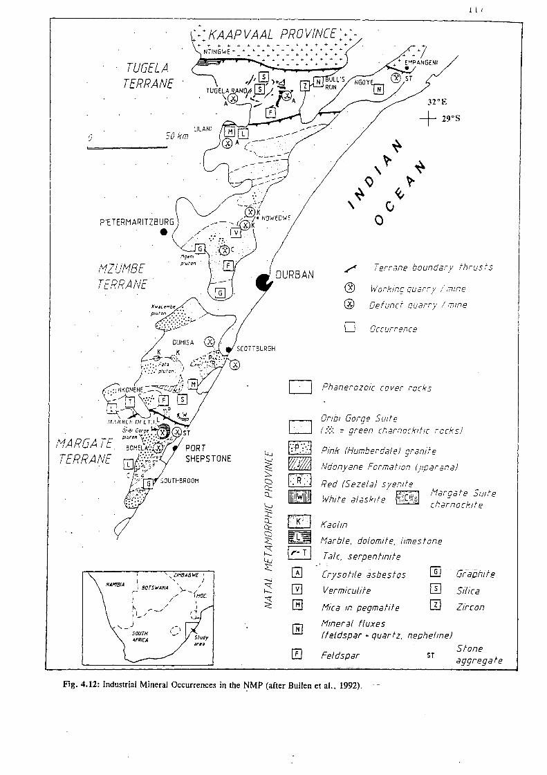
1 i I
~>KAAPVAAL PROVIN[E~+++ + + +
++++++++++++++++ NTINGwE ................................................ + ............... ...
~""""-~ ....... +++++++++
TUGELA TERRANE
o 50km
PIETERMARITZBURG
• !1ZU!1BE TERRANE·
ULANI
, , llNBAB WE I
I ' I NANIBIA j BOTSWANA \_. /
r· " -{NOC. I / I . , , ", ~-j (~ 1-/ ,j..
,,-) '-I SOUTH '_/ ~FRI(A
++++++ ...
D
o [·;p·;··1
' .....
m VR·::j
H ('k·j
m1 I,,· T I o G GJ
o
./ Terrane boundary thrus f 5
~ Working quarry,' (T1Ine
@ Defunct quarry / mine
o Occurrence
PhanerozoIc cover rocks
Orlbl Gorge Suite (::;:: = green charnockitlC recks)
Pink (Humberdale! granite
Ndonyane FormatIOn (jlparana!
Red (Sezela! syenite
White alasklte
Kaolin
Nargate Sutfe charnoekite
Narble. dolomlfe. limestone
Talc. serpentinite
[rysof!le asbestos
Vermiculite
Hiea In pegmatite
Hineral fluxes
@J Graphite
IT] Silica
m Zircon
(feldspar + quartz. nepheline)
Feldspar ST Stone aggregate
Fig. 4.12: Industrial Mineral Occurrences in the t:'IMP (after Bullen et al.. 1992).

118
Table 4.7: Potential Dimension Stone Lithologies in the Mzumbe Terrane
Host Lithology Description Comments
Humberdale Granite Medium- [0 coarse-grained. foliated granite. Up Contains zones with unattractive (pink) [0 1 cm large. pink K-feldspar mesocrysts xenoliths and biotite schlieren.
(Eglington et aI., 1991).
Sezela Suite (red) Pink to red syenites. Has large, relatively unfractured outcrops.
Ndonyane Formation Highly foliated, streaky acid gneisses and May provide an attractive migmatites. ' Juparana'*
Kwalembe and Fafa Sulphide-poor. siliceous, massive charnockite Unknown potential. Plutons plutons of the Oribi Gorge Suite.
Data from Bullen et aI., (1992). *Juparana is a Dimension Stone Industry term used to describe a highly foliated. streaky orthogneiss which also contains leucosomes/melanosomes (pers. Comm. R.Thomas, 1998).
4,2.7.2. Kaolin Derived from Proterozoic Granites
Kaolin, derived from weathered granites of the Mzumbe Terrane, occurs at a number of
localities in the Inanda-Ndwedwe area, some 30 kIn north-northwest of Durban (Fig.4.12). The
kaolin in this area is associated with residual lateritic weathered profiles which may represent
the remnants of an ancient Tertiary land surface (Partridge and Maud, 1987, cited in Bullen
et al., 1992). Bullen et al. (1992) reported that, in places, these granitoids may also have been
hydrothermally altered. In the area where the best quality kaolin is developed, much of the
weathering and hydrothermal activity appears to be associated with post-Natal Group faulting.
Small-scale mining operations e.g. the Snow White Mine (Fig. 4.13), which was mined from
1952 to 1959, selectively exploited the purest, whitest kaolin, while small pits were dug by
local tribes, who used the kaolin mainly for medicinal and decorative purposes. Exploitation
of the kaolin has been limited to a large extent by the iron staining that resulted from residual
lateritic weathering. However, a new beneficiation technique (which is able to remove soluble
iron oxide coatings from the clay particles), has been developed by Minemet Industrial
Minerals (Bullen et al., 1992), and has resulted has renewed interest in the clay deposits of the
Ndwedwe area. Minemet Industrial Minerals currently operate a clay' beneficiati-on' plant
situated near Inanda. Prospective deposits for this venture include a SkID-long;' 300 m wide,
steep, southerly dipping aplitic dyke, which contains up to 40% kaolin, and very little
unwanted mica. Reserves to a depth of 15 m have been estimated at 10 Mt.

CHINA CLAY
MINE •
~ EB KWAMAGALANGA
COQWE~' . _snow Whlt~ -=.: ~EB ---=- - EB
OSBORNE CLMS
~~ Owyko I illit e
Notol Group
MBOZAMO
EB
Bosement Complex
0 2 I I
ED Koolin
occ urrence
~Rood
4 6 I
8 I
119
---.;:;) KWASONKOMBA
KWANOZANO~_
29°30'
~---. -'-- -- -
l';,. l';,.
l';,. l';,. l';,.
-0
km 0
l';,. l';,. ~ ,...,
29°43'
Fig. 4.13: Proterozoic Granite-derived Kaolin occurrences in the Inanda-Ndwedwe area of KwaZulu-Natal (after Heckroodt, 1992).

120
Mazibuko (1987, cited in Heckroodt, 1992) investigated the clay mineralisation of the
Ndwedwe area in detail and two of his analyses of clay, one from the Snow White Mine and
the other from Kwa Nozandla (Fig. 4.13), are shown in Table 4.8. The Kwa Nozandla deposit
is estimated to spread over 13 000 hectares, to a depth of 80 m, and extensive drilling would
be required to prove reserves.
Table 4.8: Properties of two Kaolin Deposits in the Inanda-Ndwedwe Area
Deposit Name I Kaolinite (%) I Quartz (%) I Feldspar (%)
I Soow Wh;to
I 30
I 55
I IS
I : Kwa Nozandla 40 50 10
Data from Heckroodt (1992).
Much potential for kaolin mineralisation exists within the NMP, especially in the coarse
grained, porphyritic granitoids of the Oribi Gorge Suite. Bullen et al. (1992) suggest that
exploration should be directed towards areas in which faulted, weathered, feldspathic rocks
predominate. In addition, areas underlain by Tertiary lateritic weathering profiles may also be
targeted, as the known kaolin deposits are fonned in these environments. Mazibuko (1987,
cited in Heckroodt, 1992) attributed the formation of kaolin in this moist, high rainfall area,
to the downward percolation of surface water which leached the feldspar-rich granite. The
kaolinisation took place preferentially in a zone between the upper and lower levels of a
fluctuating water table, immediately below the contact between the granites and overlying
Natal Group sandstones, as well as along faults.
4.2.7.3. Industrial Mineral Deposits in the Mzumbe Terrane of Uncertain Economic Potential
Deposits of silica, mica, feldspar, limestone and chrysotile asbestos are also known in the
Mzumbe Terrane, but most deposits require further investigations to determine their economic
potential. In many cases, the rugged terrane, remote localities and small sizes of deposits has
hampered their exploitation. These mineral occurrences are described in Table 4.9, and their
locations shown in Fig. 4.12.
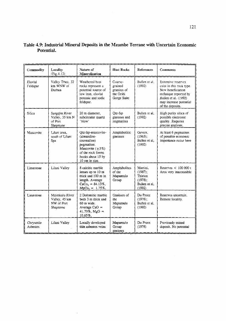
121
Table 4.9: Industrial Mineral Deposits in the Mzumbe Terrane with Uncertain Economic Potential.
Commodity Locality Nature of Host Rocks References Comments (Fig.4.12) Mineralisation
Eluvial Valley Trust. 32 Weathered host Coarse- Bullen et al. Extensive reserves Feldspar km WNW of rocks represent a grained (1992) exist in this rock type.
Durban potential source of granites of New beneficiation low iron, eluvial the Oribi technique reported by potassic and sodic Gorge Suite Bullen et al. (1992) feldspar. may increase potential
of the deposits.
Silica Sangqhu River 20 m diameter, Qtz-fsp Bullen et ai, High purity silica of Valley, 35 km N subcircular quartz gneisses and (1992) possible electronic of Port 'blow' migmatites quality. Requires Shepstone precise analyses.
Muscovite Lilani area, Qtz-fsp-muscovite- Amphibolitic Gevers, At least 6 pegmatites south of Lilani (almandine- gneisses (1963); of possible economic Spa tourmaline) Bullen et ai, importance occur here
pegmatites. (1992) Muscovite (±5%) of the rock forms books about 15 by 10 em in size.
Limestone Lilani Valley 8 calcitic marble Amphibolites Martini, Reserves < 100 000 t lenses up to 10 m of the (1987); Area very inaccessible thick and 100m in Mapumulo Thirion length. Average Group (1978); CaC03 = 84.13%, Bullen et aI, MgCo3 = 1.75%. (1992)
Limestone Mzimkulu River 2 Dolomitic marble Gneisses of Du Preez Reserves uncertain. Valley, 45 km beds 3 m thick and the (1976); Remote locality. NW of Port 60 m wide. Mapumulo Bullen et ai, Shepstone Average CaO = Group (1992)
41.70%, MgO = 10.65%.
ChrysotiIe Lilani Valley Locally developed Mapumulo Du Preez Previously mined Asbestos thin asbestos veins Group (1976) deposit. No potential
gneisses -

122
4.3. The Margate Terrane
Rocks of the Margate Terrane are exposed south of the Melville Thrust Zone, though its
southern boundary is not exposed. This granulite facies terrane has the fewest documented
occurrences of metalliferous minerals of the three Terranes in the NMP. However it is host to
the substantial. economically exploited Marble Delta limestone deposit near Port Shepstone.
4.3.1. Tonjeni Au Occurrence
The Tonjeni area is located 30 km northwest of Port Shepstone (Fig. 4.14), where outcrops
of the Turtle Bay Suite (a bimodal gneissic mafic noritoid-felsic enderbite/charnockite
association) in the Margate Terrane, have been reported by Thomas et al. (1992a). Random
chip sampling of the area (Bekker, 1986) revealed gold concentrations of between 0.10 and
0.17 ppm. According to Bullen et al. (1994) the highest gold concentrations occur in noritic
two-pyroxene granulites and melanocratic enderbites which contain up to 5 % disseminated
sulphides. No records of follow-up investigations are available.
'310 E
.Ixopo
D Phanerozoic cover rocks
MZU/18E TERRANE
Intrusive rocks
Supracrustal rocks NARGA TE TERRANE
D Intrusive rocks
r)(::~:;l Supracrustal rocks
,Proterozoic intrusion-related gold:
, <> Disseminated (~= Dumisa l1ineJ
+ Skarn-type
o
/' Melville Shear Zone
// Fault
Fig.4.14:MetaIliferous Occurrences in the Margate Terrane. Gold Deposits of the Mzumbe Terrane are also shown (after Bullen et al.. 1992). ..
SOkm

123
4.3.2. Bomela Gold
At Bomela, some 10 km west of Port Shepstone (Fig 4.14), a very low grade skarn-type gold
occurrence has been reported (Bekker, 1985a). White, diopside-bearing quartzite enclaves
identified within the southeastern marginal zone of the Oribi Gorge porphyritic charnockite,
are host to the mineralisation.
Bekker (1985a) considered the metasomatic skarn-type enrichment to be related to the
emplacement of the host charnockite host. Field investigations revealed a high percentage of
sulphides (mainly pyrite, pyrrhotite, chalcopyrite and niccolite) along microfractures within
the rock. Skarn-type alteration was found to predominate within diopside-bearing quartzite
enclaves, which host the mineralisation. Initial sampling of the skarn-type rock produced
encouraging results (2.10 glt over ± 7 m), with anomalously high values of Ni, Cu and As.
However, follow-up chip sampling at 1 m intervals produced much lower values (highest 0.10
glt Au). Consequently, the prospect was abandoned.
4.3.3. Lithium-bearing Pegmatites
In the Highbury area, some 18 km north of Port Shepstone (Fig. 4.15), a number of
spodumene-bearing leucocratic pegmatites have been identified intruding the granulite-grade,
mafic gneisses and calc-silicate rocks of the Mucklebraes Formation (Thomas et aI., 1994a).
o
---------
~ ~
30" 35S
_ '. D Cover rocks Port Shepstone
NATAL METAMORPHIC PROVINCE
[ <....:J I HIGHBURY PEGMATITE
~ Late tectonic plutons L.:.;.:..J (-1040 - 1070 Ma)
1--~j Mzumbe Terrane .-.-- .,.-/
['-:"'-:1 Margate Terrane ....... -.. •• ••• 'O
Fig. 4.15: Regional geological setting and location of the Li-bearing Pegmatites (after Thomas et aI., 1994a).
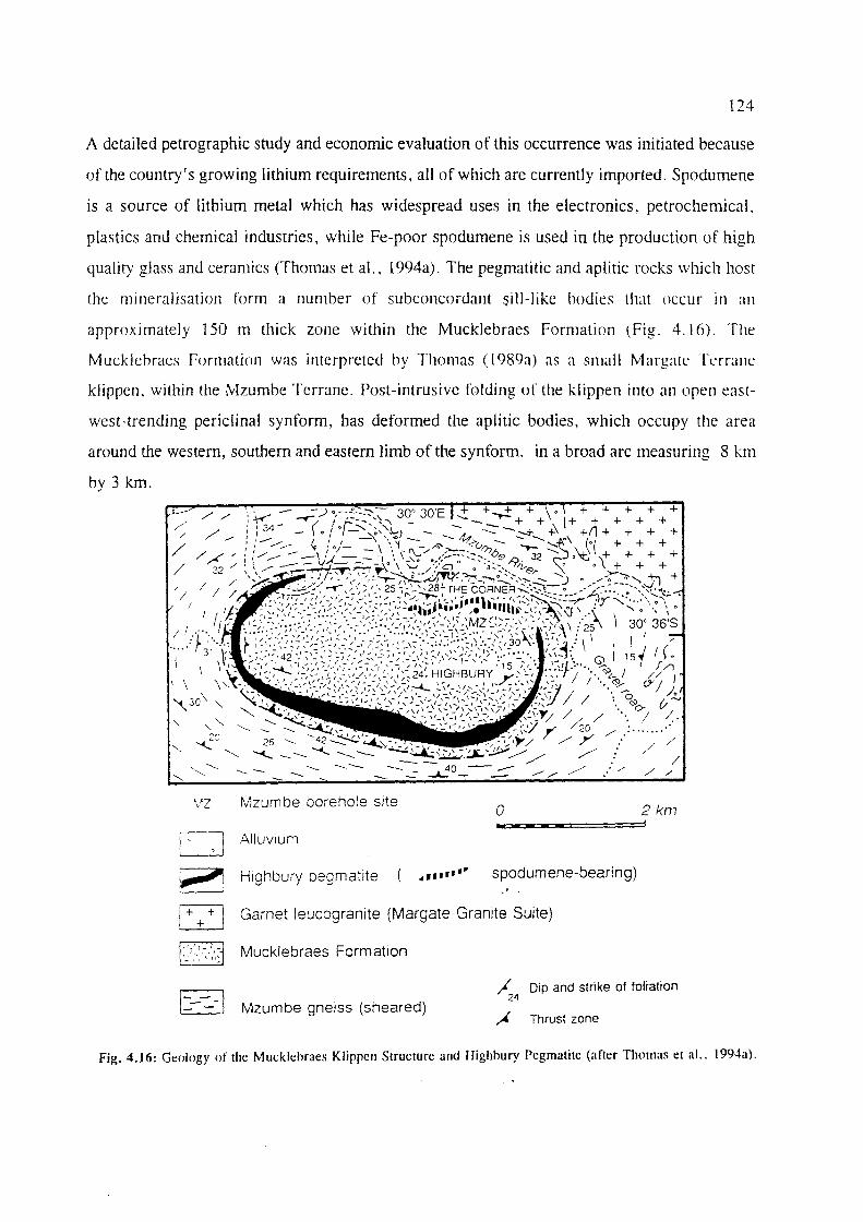
124
A detailed petrographic study and economic evaluation of this occurrence was initiated because
of the country's growing lithium requirements, all of which are currently imported. Spodumene
is a source of lithium metal which has widespread uses in the electronics, petrochemical.
plastics and chemical industries, while Fe-poor spodumene is used in the production of high
quality glass and ceramics (Thomas et aI., 1994a). The pegmatitic and aplitic rocks which host
the mineralisation form a number of subconcordant Sill-like hodies that occur in an
approximately 150 m thick zone within the Mucklebraes Formation (Fig. 4.16). The
M ucklehracs rormation was interpretcd hy Thomas ([ 989a) as a small Margate Terralle
klippen, within the Mzumhe Terranc. Post-intrusive folding of the klippen into an open east
west-trending periclinal synform, has deformed the aplitic bodies, which occupy the area
around the western, southern and eastern limb of the synform, in a broad arc measuring 8 km
by 3 km.
MZ Mzumbe borehole site o 2km .. D AllUVium
~ Highbury pegmatite 4 ..... ·.. spodumene-bearing)
~ Garnet leucogranite (Margate Granite Suite)
~ ~
~ - -- -
Mucklebraes Formation
Mzumbe gneiss (sheared) ~4 Dip and strike of foltation
"i Thrust zone
Fig. 4.16: Geology of the Mucklehraes Klippen Structure and Highhury Pegmatite (after Thomas e! al.. 1994a).

125
An exploratory borehole was drilled to intersect mineralisation at depth. The spodumene was
found to occur within a number of sills but the bulk of the intrusives were barren,
garnetiferous aplites, implying that the Li-rich pegmatites may have been the result of lateral
fractionation within the intrusive system. Core sampling from this borehole revealed > 23 %
modal spodumene, which equated to ± 2 % Li20 on average. The spodumene grades decrease
with depth and intrusions below 200 m were found to be barren. The Li-rich spodumene occurs
predominantly as equant, ovoid to irregular crystals up to 40 cm across, in graphic and
symplectic intergrowth with quartz. No discrete spodumene crystals were observed.
Trial beneficiation by flotation carried out by the Council for Geoscience to give a product with
> 7 % Li20 was shown to be possible and the different grades available at Highbury would be
able to satisfy both the glass and ceramics industries and be an important source of lithium
salts. Accurate ore reserves would require further drilling. However indications are that this
deposit can be equated in size with other medium sized pegmatite deposits. These factors,
coupled with the relatively easy accessibility and close proximity to infrastructure, would no
doubt make this deposit economically viable. Potential by-products from exploitation of this
deposit include dimension stone (suitably extensive aplitic phases are developed) and feldspar
with a high albite content.
4.3.4. Industrial Mineral Deposits
4.3.4.1. Marble: The Marble Delta Limestone Deposits
Three large quarries in the 'Marble Delta' area (Figs. 4.12 and 4.17), 14 km northwest of Port
Shepstone, are currently the largest producers of limestone products in the country. Small-scale
quarrying probably started around 1866 (Martini, 1987). These supracrustal, granulite facies
dolomitic and calcitic marbles of the Marble Delta Formation (Thomas and Otto, 1991), are
highly deformed and extensively intruded by various granitoids and chamockites. The marbles
are predominantly white to grey. However minor green, blue and black varieties are also
developed due to contact metamorphic effects caused by intrusive chamockitic sheets (Bullen
et aI., 1992). The marbles are generally considered to be too coarse-grained for use as a
dimension stone, with an average grain size of 15 mm (Martini, 1987).
Umzimkulu Lime's two quarries produce a range of carbonate fillers for use in high quality

126
paints, plastics, paper, toothpaste and bread. The dolerite dykes intruding the limestone are
also exploited for their high alumina content which is required for certain custom-made
products. Annual production of limestone products is of the order of 300 000 to 400 000 tons.
Adjacent to the two main quarries, Natal Portland Cement (NPC) mines a less pure calcitic
marble from their Simuma Quarry. The marble here contains considerable quantities of Fe and
up to 6% MgO. The rock is crushed on site and conveyed a short distance to a large kiln,
where klinker is produced for use in NPC's cement plant.
Due to the complex structure and stratigraphy of the region (Fig. 4.17), there are many other
potential occurrences of limestone in the vicinity of the existing quarries. These are currently
being investigated to increase the lifespan of the operation. Current reserves however, should
last well into the next century at the present rate of mining.
4.3.4.2. Dimension Stone
At Bomela, near Port Shepstone (Fig. 4.12) a dark green charnockite similar to that mined at
Cato Ridge in the Mzumbe Terrane, was quarried on a limited scale in the early 1980's
(Bekker, 1982). The deposit was found to be unsuitable for use as dimension stone because of
close fracture patterns and the presence of abundant biotite xenoliths. Furthermore, the
presence of abundant sulphides in the rocks would affect long term durability and appearance
of the polished rock surface. Bullen et al. (1992) related some of these problems to the position
of the quarry, which was situated in close proximity to the faulted, fractured, and contaminated
southeastern margin of the Oribi Gorge pluton. It is likely that better, less fractured material
could exist further from the fault zone. Other potential dimension stone deposits are described
in Table 4.10, with localities being shown in Fig. 4.12.
Table 4.10: Potential Dimension Stone Lithologies in the Margate Terrane (after Bullen et aI., 1992).
Host Lithology Description Comments
Oribi Gorge Pluton Sulphide-poor, siliceous, massiv~ Unknown potential charnockite pluton of the Oribi Gorge Suite
Margate Granite Suite Relatively fine-grained, non-porphyritic Extensively developed along the south-charnockites within felsic _granites- eastern ma~gin of the Oribi Gorge Suite
Alaskitic Granite Almost pure, white alaskitic granite with May be mined as a by-product when this (Muckiebraes Formation) extensive aplitic phases. deposit is exploited for lithium

0
0 0
0 0 0
0
0
0 0
0
0
o
0 0
0 0
0 0
0
0
0
0
0
o
+
+
+ +
~.
~.+~
ill' +
+
+
+
+
/' /'
+
+
+ +
+
+ +
~ + +
+~+
LEGENDILEGENIJ/:
r~ Soil and unconsolidated surficial deposits )Quarcrnar}' ~ (;rolld ell ollgekollso/idcerde oppeM.!lakafsettillgs KWIltenlCr
ro-ol Sandstone and tillite l Dwyka Formation l Karoo Sequence ~ Salldsteen ell ~illiet {Formas;e Dwyka f opct!Ilvoigillg KdroO
~ Granite and s~bortlinate dolerite ~ Gmllier ell omfergeskikre dolaiel
I-~ MctaseJimcnts and metavolcanics ~ Alt'tasedi//l{,llt~ ell ml.'t(lvltlk.lIIiese gt'steelltt's
..
calciticmarble Kalsi/iest'm,lrmer
Dolomiric marble Dolomiticse murmer
Impure Olarhlf (including replacement bodies) OIlSU;Wl'r mll';JlI'r (iIlS/uitt'll.ie v01.l.mgillgsUggIl11lr:)
500 250
t-----J E=l
Fig. 4.17: Detailed Geological Map of the Marble Delta Area. Southern KwaZulu-Natal (after Otto. 1977).
500 m
I

128
4.3.4.3. Industrial Mineral Deposits in the Margate Terrane with Uncertain economic Potential
The deposits are described in Table 4.11, with localities shown in Fig. 4.12. These mineral
occurrences are all located close to Port Shepstone, which is well served by road and rail links.
Table 4.11:
Commodity
Feldspar
Graphite
Graphite
Stone Aggregate
Industrial Mineral Deposits in the Margate Terrane with Uncertain Economic Potential.
Locality Host Rocks Nature of Reference Remarks Mineralisation
Highbury Pegmatite sills in High albite feldspar Thomas et Maybe mined as a Pegmatite, the Mucklebraes a!., (1994a) by-product when N of Port Formation lithium is mined here Shepstone (Fig. 4.15)
10 km west Granulitic gneiss Steep S-dipping Bekker, Ore reserves to a of of the Leisure graphite-sillimanite (1985b) depth of 300 m > Southbroom Bay Formation schist layer ± 3 m 900 000 t at ± (Fig. 4.12) thick over 350 m 4.28 % graphitic
strike length carbon. Uneconomic due to inferior grade
Marble Limestones of the Local concentrations Otto, (1977) Uneconomic Delta Marble Delta of graphite of (Fig. 4.12) Group possible biogenic
origin
Umzimkulu Margate Granite Gneissic Bullen et Quarry recently Quarry, 8 Suite gametiferous a!., (1992) ceased production kmNWof leucogranites Port Shepstone (Fig. 4.12)
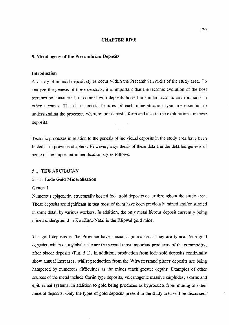
129
CHAPTER FIVE
S. Metallogeny of the Precambrian Deposits
Introduction
A variety of mineral deposit styles occur within the Precambrian rocks of the study area. To
analyze the genesis of these deposits, it is important that the tectonic evolution of the host
terranes be considered, in context with deposits hosted in similar tectonic environments in
other terranes. The characteristic features of each mineralisation type are essential to
understanding the processes whereby ore deposits form and also in the exploration for these
deposits.
Tectonic processes in relation to the genesis of individual deposits in the study area have been
hinted at in previous chapters. However, a synthesis of these data and the detailed genesis of
some of the important mineralisation styles follows.
5.1. THE ARCHAEAN
5.1 .1. Lode Gold Mineralisation
General
Numerous epigenetic, structurally hosted lode gold deposits occur throughout the study area.
These deposits are significant in that most of them have been previously mined and! or studied
in some detail by various workers. In addition, the only metalliferous deposit currently being
mined underground in KwaZulu-Natal is the Klipwal gold mine.
The gold deposits of the Province have special significance as they are typical lode gold
deposits, which on a global scale are the second most important producers of the commodity,
after placer deposits (Fig. 5.1). In addition, production from lode gold deposits continually
show annual increases, whilst production from the Witwatersrand placer deposits are being
hampered by numerous difficulties as the mines reach greater depths. Examples of other
sources of the metal include Carlin type deposits, volcanogenic massive sulphides, skarns and
epithermal systems, in addition to gold being produced as bypro ducts from mining of other
mineral deposits. Only the types of gold deposits present in the study area will be discussed.

130
Fig. 5.1: Major sources of world gold production (after Groves and Phillips, 1987). Greenstone production accounts for 20 000t Au. Greenstone lode-gold and other lode-gold deposits now account for a significant proportion of world gold production.
The genesis of lode gold deposits has been widely debated~ and an outline of salient factors in
their formation is attempted here, to create a better understanding of the deposits in the area
under investigation. Many theories have been formulated in an attempt to explain the genesis
of lode gold deposits from the Archaean. These theories analyze the sources of the metals and
other components in the veins, sources of the mineralising fluids, the means of their
mobilisation and transport and the wall rock alteration, and final precipitation of the minerals
in the depositional sites. These investigations provide valuable insight into the various factors
responsible for the formation of these deposits, and wm be discussed later.
Previous literature regarding lode gold deposits concentrated mainly on greenschist grade
Archaean deposits as these deposits were the most important gold producers. However, it was
recently found that all lode gold deposits within metamorphic terranes of different grades
(subgreenschist, amphibolite and granulite grades) and ages (Proterozoic to Cenozoic) have
similar characteristics to those found within Archaean terranes, and were all likely to have

131
formed by a similar process (Kerrich and Wyman, 1990; Kerrich, 1993), A refinement of
previous theories followed, leading to lode gold deposits of all ages now being viewed as a
single class of deposit (or coherent genetic group - Groves, 1993) which formed over a depth
range through all metamorphic grades (Fig. 5.2).
This has led to the formulation of the crustal continuum model for lode gold deposits (Groves
et a/., 1991; Groves, 1993). Evidence gathered by Groves (1993) from structurally controlled
lode-gold deposits on a global scale has revealed that these deposits represent a crustal
continuum and formed under various crustal regimes over at least a 15 kIn crustal profile at
PI conditions ranging from ISO°C at < 1 kb to 700°C at about 5 kb.
SCHEMATIC CRUSTAL PROFILE
A T TIME OF GOLD MI~JE RALIZA TION
Meteoric waler?
Mantle/lower crust Pb',Sr'.Au?
Fig. 5,2: Schematic crustal proflle of a hypothetical. continuous hydrothermal system over a crustal range of 25 Ian. The series of deposits shown here is unlikely to occur in anyone area (after Groves, 1993).
The crustal continuum model may be particularly relevant for KwaZulu-Natal, as structurally
hosted, epigenetic gold deposits occur within Archaean and Proterozoic host rocks (Tugela and
132
Mzumbe Terranes). However, although the underlying greenstones are considered a source of
the gold, local volcanogenic exhalative processes may also be presumed a source, in light of
the tectonic history of these terranes (Thomas et aI., 1994b).
5. 1 . 1 .1. Genesis of Structurally-hosted Lode Gold Deposits
The basic process whereby lode gold deposits form is clearly understood (Fig. 5.3), and is one
where ore-bearing hydrothermal fluids from depth wer.e mobilised and transported due to
advection along major structural discontinuities to finally precipitate mineralisation in second
order depositional sites which provide the most favourable geological conditions (structure,
host rock composition, fluid chemistry, etc.).
In order to gain a general insight into Archaean lode gold deposits, it is important to analyze
the basic mechanisms that lead to the formation of these deposits. These factors may then be
used to assist in providing a better understanding the mechanisms involved for the formation
of similar deposits found in the study area.
20Km
~ Spdirr1Pnl~ry succession
D Meficl Ullremafic Volcanic rocks
GJJ Grnnitoid
Allerntlon
first order structure
second or der 9ubsidiary slructure
/ fluid path
Fig. 5.3: Schematic diagram showing transportation of mineralising fluids through the crust via a major structural discontinuity into second-order subsidiary structures (after Eisenlohr et al.. 1989).
133
A brief overview of the following aspects is considered important to gain a better insight into
the genesis of Archaean lode gold deposits. Much of the data represents research from workers
in Western Australia and Canada, where such deposits are widespread and more extensively
studied. Ongoing research will continue until a model which has broad constraints for all
deposits can be presented.
The following parameters are considered essential for a better understanding of the genesis of
these epigenetic, structurally-hosted lode-gold deposits:
1] The source of the gold
2] The source of the mineralising fluids and transport
3] Mechanisms of concentration in fluids
4] Structure and wall rock alteration
5] Cause of Au precipitation
6] Timing of the mineralisation
The different models proposed encompass many characteristics of the Archaean lode gold
deposits found in the study area, as each model takes into account structurally controlled
mineralisation hosted in greenschist facies, volcanic-dominated sequences containing Fe-rich
rocks such as basalts, dolerite or BIF.
1] Source of Gold in Archaean Host Rocks
For the formation of any mineral deposit, it is logical to first consider the primary source from
which such metals can be attained. Early metallogenic models regarding the source of gold in
Archaean deposits centred mainly on theories that involved the leaching of the precious metal
from the country rocks by fluids that were mobilised 4l,le to a heat source such as granite
plutons, or that the plutons themselves were the source of the gold-bearing fluids. That the
intrusives generated the heat which caused mobilisation of fluids due to dehydration of country
rocks, is also true for many deposits.
Essentially, these earlier theories assumed that all types of country rock were gold-bearing.
However, it was pointed out by Keays (1984) that this is not always the case, as only certain
rock types contain enough gold to form large gold deposits. Detailed studies by Keays revealed
that the initial gold-enriched host rocks were most likely to be from the generation and

134
emplacement of komatiitic magmas and high-Mg basalts which were derived from relatively
high degrees of mantle melting. Keays (1984) suggested that the reason for the enriched
precious metal contents of these rocks is due to them becoming S-saturated at a late stage due
to their much higher temperatures when compared to most other magmas. As a result, the
proportional loss of Au and other chalcophile elements due to scavenging by immiscible
sulphide melts was not significant.
Komatiitic magmas are extensively developed in Archaean greenstone terranes because of the
higher geothermal gradients that prevailed, and this serves to explain the widespread
development of Au deposits in Archaean rocks. Although these magmas had high Au contents
when extruded, the Au available from these (i.e. Au not locked up in silicate and oxide phases)
to form epigenetic Au deposits (which are due to regional metamorphism and deformation of
the volcanic pile) is lost long before ore-forming processes could begin. A study on MORB
pillows by Keays and Scott (1976) revealed that the glassy rims of the pillows contain
significantly higher concentrations than the interiors. According to Keays and Scott (1976) the
loss of this Au could be attributed to the reaction of the hot lavas with seawater, soon after the
formation of basaltic pillows, which caused the dissolution of most of the Au (and S) from the
pillow interiors. Keays (1984) suggested that this process occurred long before the volcanic
piles were subjected to metamorphism and deformation (the ore-forming environment) which
culminates in mineral deposits.
To explain the source of mineralisation in various different types of mineral deposits seen at
present, an intermediate trap for these precious metals was therefore suggested, to retain the
mineralisation until the ore-forming environment was created. Ideal lithologies suggested for
this role are interflow chemical sediments, such as .elF. Some BIF lithologies, e.g. in
Zimbabwean greenstone belts, are important host rocks to Au mineralisation.
This mineralisation would then be remobilised during subsequent events,-which may be related
to intrusives which generate heat and create structural conduits along which fluid flow is
focused and deposited in their final sites.
According to Keays (1984), ultramafic intrusions form another possible source of Au,
especially those enriched in S. These intrusions, in the form of dunitepods and lenses, would

135
not have been affected by seawater metasomatism that initially leached out the Au in the
volcanic lavas. However, the source of the metal may also depend on associated lithologies and
conditions prevailing at the time of deposit formation. For the lode gold deposits in the
Archaean Superior Province of Canada, four genetic models have been proposed to account
for the source of the mineralisation (Card et al., 1989). These are briefly described below.
In the magmatic-hydrothermal model, it is proposed that the mineralised hydrothermal fluids
were derived from ascending magmas generated during Late-Archaean tectonism and
metamorphism (Burrows et al., 1986). Likely source magmas include felsic porphyries
(Macdonald and Hodgson, 1986, cited in Card et aI., 1989) or domal tonalite gneiss
granodiorite quartz monzonite bodies that intruded the lower part of the greenstone belts
(Burrows et aI., 1986).
Groves and Phillips (1987) proposed the metamorphogenic model where the greenstone belts
are considered to be the source of the gold and all the other components of the hydrothermal
fluids. Granulitisation of the lower crust as a result of the streaming of CO2 from the mantle,
causing the release of H20 and the onset of partial melting was proposed by Cameron (1988)
and Colvine et aI.(1988). These reactions would cause leaching of gold and light intermediate
lithophile elements from the lower crust, resulting in gold-bearing H20-C02-rich fluids.
Finally, volcanogenic origins are also considered likely sources of mineralisation and are
thought to have formed by submarine exhalative processes during the waning phases of
volcanism (Valliant and Bradbrook, 1986, cited in Card et aI., 1989).
2] Source of the Mineralising Fluids and Transport
Fluid inclusion studies do not reveal a unique source 9f mineralising fluids for lode gold
deposits. According to Ho et ai. (1985), Groves and Phillips (1987) and Pirajno (1992), fluid
inclusion studies from quartz veins related to mineralisation indicate that the fluids are all very
similar: being low salinity « 2 wt. % NaCI equivalent), low density, reduced, near-neutral
to slightly alkaline, H20-C02-CH4-rich fluids with variable H20:C02:~ ratios for different
deposits. Groves and Phillips (1987) suggested and analyzed several alternatives likely to be
the sources of such fluids, including mantle degassing, magmatic fluids from granitoid
batholiths and felsic (porphyry) intrusions and metamorphic fluids, while Hutchinson and
136
Burlington (1984) also suggested recirculated seawater. All these fluid sources have the
potential to provide the mineralising fluids, and each deposit may be formed by fluids from
different sources.
Previous investigations centred on metamorphic fluids derived from the devolatilisation of
greenstones as the predominant source of hydrothermal fluids and solutes in the formation of
the major deposits (the metamorphic-replacement model of Groves and Phillips, 1987.)(Fig.
5.3) . This was reasoned because of the low-pressure metamorphism typical in greenstone belt
evolution (e.g. Binns et al., 1976, cited by Groves and Phillips, 1987), which implies high
geothermal gradients (Groves and Phillips, 1987). According to these authors, this results in
positive P-T slopes of most devolatilisation curves at low pressures, implying a restricted
temperature interval over which devolatilisation of greenstones occurs. The restricted
temperature interval causes most devolatilisation over a relatively small depth, while melting
of the greenstone pile is inhibited due to the high geothermal gradient at relatively low
pressures. Carbon isotope data indicated that the CO2 was likely to have been derived from
mantle-derived carbonate during mantle-degassing along crustal-scale fault zones. The fluids
resulting from the devolatilisation of the greenstones (as a result of grain reactions) extracted
Au from the greenstone pile and were channelled along greenstone-scale faults (Fig. 5.4). Au
was then deposited in, or adjacent to, fault or shear zones in response to decreased temperature
and fluid/wall-rock reactions. Where BIF lithologies are intersected, replacement of Fe oxides
by Fe sulphides and gold occurs.
The influence of nearby magmatic intrusions to mineralisation has been cited by many workers
in the study area. According to Groves and Phillips (1987), although the intrusions did not
contribute significantly to mineralisation, the magma emplacement and mineralisation may have
been the result of the same thermal event, with magmas being generated due to melting at
deeper crustal levels. These magmas may then have been selectively emplaced along crustal
fractures and at the same time, generated the second-order structures where mineralisation is
sited.
What is clear is that the ore fluid common to all deposits is deeply sourced and was derived
from, or interacted with, granitic rocks below the greenstone belts, while some of the ore-fluid

137
components were also derived from other sources, as indicated by C and 0 isotope data
(Groves, 1993). This is due to the fact that the high-temperature fluids from depth in these
crustal-scale hydrothennal systems advected along vertically extensive structures through mid
to lower crustal granitoid-gneiss complexes to the overlying depositional sites. Meteoric and
seawater as ore fluid components are suggested for those "deposits hosted in brittle structures
at shallower crustal levels in very low grade metamorphic settings.
[A---Gr~~nslon~
Carbonar:~ous
B
SectIon shown
M.1nlle .".,- ... ----
•• w grarn!Old " • "
laull
- C<Htoon~rPd gree-nsl,H1es (mantle degaSSing ?)
. " " ,. "\":::
(High geothermal gradient·· partial melting absent] Pre-mefamorOhic
carbona lion
Fig. 5.4: Schematic representation of the metamorphic-replacement model for the generation of Archaean gold deposits (after Groves and Phillips. 1987).

138
Any steeply inclined plane may constitute the pathway for the migration of fluids. In tenns of
ore deposition, major structures such as faults, shear zones and thrusts are considered most
important channels for the movement and focusing ofhydrothennal fluids (Groves and Phillips,
1987; Pirajno, 1992). The channelisation of the fluids and upward migration into the major
structures has been attributed to mass transfer processes such as seismic pumping (Sibson et
a!., 1975), which produced high fluid/rock ratios.
3] Mechanisms of Concentration in fluids (liberation from original state)
For Au to be stable in solution, it must fonn compounds with other elements III the
hydrothennal fluid before being transported. Au in hydrothennal fluids predominantly occurs
in the Au1+ oxidation state (Seward, 1984), which can fonn stable complexes with many
elements and compounds.
The fluid in which gold concentrates is generally of low salinity, is CO2-rich, and is likely to
be richer in potassium than sodium (Fyfe and Kerrich, 1984). According to Fyfe and Kerrich
(1984), gold can fonn a wide range of complexes with ligands such as the halide ions, sulphur
species, carbonyls based on CO, and nitrogen-containing species, along with complex arsenic
derived species which may all be present in hydrothennal solutions. The most common appears
to be a reduced sulphur complex such as HAu(HS)2 with which are associated metals such as
As, Sb and W, and sulphur which may all have been derived from the volcanic pile and
associated sulphide-rich sediments (Groves et al., 1985).
According to Ridley et ai. (1996), bisulphide complexes have much greater potential than
chloride complexes, with the most significant complexes being Au(HS)o and Au(HS)2'.
However, according to Romberger (1991, cited in .Ridley et aI., 1996), gold-chloride
complexes become more stable than the bisulphide complexes with increasing temperature.
4] Structure and Wall Rock Alteration
In the case of lode gold deposits it is noted that only a few deposits produce the bulk of the
mineralisation, while the others are smaller and have scattered rich pockets of mineralisation.
This is due mainly to structural control of the mineralisation system, as at depth vast quantities
of mineralised hydrothennal fluids exist. These exploit sites with the most favourable

139
conditions (structure, host rock, fluid chemistry, etc.) for the precipitation of mineralisation,
thereby forming deposits of variable sizes and grades. It is also known that these deposits are
related to shear- and fracture-zones which suggests that these structures focused fluid flow and
acted as conduits for the movement of the ore-bearing fluids. The deposits are known to be of
limited lateral extent, but tend to extend to great depths.
There is a distinct association of the lode gold deposits with shearing and large scale fractures
which implies that these structures were responsible for focusing fluid flow, and also acted as
conduits for the migration of the ore fluids. All the deposits studied indicate an association with
structural discontinuities. It is well known that most of the mineralisation is located in brittle
ductile structures subsidiary to the main crustal-scale fractures. Offshoots from the main shear
zone at Klipwal gold mine are known to have grades in excess of 200 glt in some places.
Pirajno (1992), citing Eisenlohr et al. (1989), suggested two reasons for the largely
unmineralised first-order structures and the richly mineralised second-order structures.
1] Physico-chemical gradients between the two structures, such as temperature, would be
higher in first-order structures, causing migration of mineralised fluids into the second-order
structures.
2] The second-order structures were more likely to have interacted with the greenstone source
rocks, whereas the crustal-scale first-order structures interacted with a deeper (mantle) source.
On a smaller scale, as noted in deposits at Klipwal (Gold, 1993) and the Melmoth Granite
Greenstone remnant (Bullen, 1990), mineralisation is commonly located towards the centre of
shear zones, where shearing was most intense. Also of major importance was the location of
mineralisation at the contact between two rock types, with mineralisation invariably hosted in
the least competent rock type (Bullen, 1990).
Bonnemaison and Marcoux (1990) proposed a three-stage model for quartz-vein-hosted
mineralisation in shear zones. They propose that, for economic concentrations of Au in shear
zones, there had to be subsequent phases of deformation and hydrothermal fluid circulation,
which lead to enriched concentrations of Au in some preferred sites within the structure. They
suggest that gold appears in shear zones at a very early stage in the form of auriferous
140
pyrrhotite (or pyrite, arsenopyrite), and is reconcentrated by deformation and recirculation of
hydrothermal fluids in various episodes, when Au may appear in the native state.
Fluid/wall rock interaction is responsible for the distinctive laterally zoned alteration haloes
observed in all deposits, while vertical zonation is generally restricted because of heated wall
rocks (Groves and Phillips, 1987). According to Groves et al. (1991), wall rock alteration
patterns in the ore zone of greenstone successions are typified by ankerite/dolomite-white mica
(sericite) and/or biotite ± albite , with the alteration characteristically retrograde with respect
to peak metamorphism. At lower-amphibolite grade, amphibole-biotite-plagioclase assemblages
predominate, while mid-amphibolite to lower granulite-grade assemblages consist mainly of
gamet-diopside-biotite-K-feldspar minerals. The S-rich assemblages at low metamorphic grades
are dominated by pyrite, with pyrite-pyrrhotite-dominated assemblages and pyrrhotite
arsenopyrite (±loellingite) assemblages developing as metamorphic grades increase (Groves
et al., 1991).
These alteration patterns are due to complex mineralogical, chemical and textural changes due
to the interaction of the hydrothermal fluids and wall rocks, under evolving physico-chemical
conditions (Pirajno, 1992). Alteration patterns may be observed in all hydrothermal deposits,
and are related to the activity of K+ and H+ ions in the system, which affects the composition
of the wall rocks surrounding the hydrothermal system. Dominant mineral assemblages of
altered zones are related to specific alteration types, which are useful in locating the source of
mineralisation, and hence are an important tool used in exploration. The various types of
hydrothermal alteration patterns and associated mineralisation are detailed in Pirajno (1992).
Wall rock alteration patterns will largely depend on the composition and metamorphic grade
of the rocks with which the fluids interact.
For example, the different mineralogical compositions of the host-rocks at the Harewood and
Vira workings of the MGGR are responsible for the variations in wall rock alteration patterns
observed at the two deposits (Bullen, 1990). The types of alteration reported from the gold
deposits in the study area are mainly argillic, sericitic, silicic, and chloritic haloes surrounding
the mineralised quartz veins. Sericitic alteration, also known as phyllic alteration, is
characterised by the assemblage quartz-sericite-pyrite (QSP). Argillic alteration is commonly
141
found to be of supergene origin and is mainly due to increased H+ metasomatism (acid
leaching). According to Pirajno (1992), these alteration patterns are characteristic of Archaean
shear zone deposits, due to the circulation of hydrothermal fluids rich in H20 and CO2• The
pattern of alteration found in individual deposits will largely depend on host rock mineral
assemblages and their response to metasomatic effects.
5] Cause of Au Precipitation
According to Pirajno (1992), precipitation of metals from hydrothermal fluids may be due to
a number of factors, such as temperature changes, pressure changes and boiling, reactions
between wall rocks and solutions and chemical changes due to mixing of fluids. For the gold
deposits, a number of factors are responsible, mainly temperature and pressure decrease,
changes in Eh and pH, oxidation of reduced hydrothermal solutions (Hutchinson, 1993) and
reactions with wall rocks.
In the metamorphic replacement model of Groves and Phillips (1987), it is suggested that gold
deposition mainly occurred in sub-amphibolite facies regimes, under minimum P-T ranges of
1-2 kb and 350-450 0, because, according to Seward (1984), solubility of reduced sulphur
complexes decreases below ca. 500°C.
As noted earlier, Au is generally transported in hydrothermal fluids with a number of
complexing ligands. The type of ligand, however, is important in determining the conditions
required for precipitation, as outlined by Seward (1984). For example Au transported as
Au(HS)2-' a simple hydro sulphide complex, could precipitate Au in response to a drop in
temperature (due to the ascending fluid or interaction with cooler near-surface water) as well
as in response to any process which caused a decrease in Jhe activity of reduced sulphur. The
latter process may be caused by boiling, oxidation, dilution and precipitation of metal
sulphides. Oxidation of H2S together with a decrease in pH may also cause Au precipitation.
Further, gold transported as a AuC12- (chloride complex) would precipitate gold with a drop
in temperature and fluid dilution, which decreases chloride activity.
According to Groves and Phillips (1987), additional factors favouring deposition of gold in
Archaean environments include processes whereby sulphidation-· of waH . rocks occurred,·

142
simultaneously depositing Fe-sulphides and gold, especially where the fluid pathways
intersected Fe-rich rocks such as tholeiites or dolerites. Where fluid/wall rock interaction
occurs in less Fe-rich rocks, gold deposits may form due to fluid reduction and/or lowering
of pH (Groves and Phillips, 1987).
6] Timing
The timing of mineralisation generally post-dated both peak metamorphism and magmatism
(e.g. Groves and Phillips, 1987). However rare premetamorphic deposits and some
synmetamorphic deposits may also occur (Groves et aI., 1991). Mineralisation generally
occurred late in the tectonic history of an individual craton (Groves et aI., 1989; Ridley et aI.,
1996). For example, field evidence shows veins crosscutting complexly deformed lithologies
and in many cases, wall-rock alteration is generally retrograde with respect to peak
metamorphism.
Summary
The above discussion serves to highlight the variety of parameters that are applicable to the
formation of lode-gold deposits. Aspects of the genetic models proposed have to be combined
for specific deposits, not only in the study area but also on a world scale as individual deposits
may contain only a few of the characteristics that are typical of lode-gold mineralisation. There
is general agreement that these deposits are epigenetic, but the precise origin of the
mineralisation is still equivocal, due mainly to each case-study having a few unique
characteristics.
Further research into lode-gold deposits is still required to gain a complete understanding of
all the factors responsible for their formation. According to Groves (1993), the poorly
understood late tectonic evolution of granitoid-greenstone belts in the Late-Archaean is one of
the major factors against resolving the genesis of these lode-gold deposits.

143
5.1.1.2. LODE-GOLD DEPOSITS IN KWAZULU-NATAL
The lode-gold deposits in KwaZulu-Natal show many of the characteristics common to
Archaean gold deposits throughout the world. The gold deposits in the Province have not had
much attention in the literature, due mainly to their small size and lack of outcrop. Potential
for larger deposits may exist, and if one studies deposits elsewhere and applies similar
constraints and models to the terranes in the study area, this potential may be realised.
However, a common characteristic of greenstone belts is a restricted number of large deposits
being developed, with numerous smaller deposits, largely because the required structural
framework had not sufficiently evolved.
In the Archaean rocks of K waZulu-Natal, lode-gold mineralisation occurs in the N ondweni and
Melmoth granite-greenstones, and in the metasediments of the Mozaan Group. To analyze the
mineralisation in these different host terranes, models of tectonic evolution proposed for host
lithologies must initially be taken into account, followed by the application of some of the
parameters discussed earlier in this chapter.
5.1.1. 2.1. The Granite-Greenstone Terrane
The lode- gold deposits in the Archaean granite-greenstone terrane of KwaZulu-Natal compare
favourably to typical syn-cratonization Archaean lode gold deposits found worldwide (e.g.
Bullen et aI., 1994; Versfeld, 1988). Studies on the gold deposits of the Nondweni Group
greenstones by Versfeld (1988), revealed no relationship between the distribution of gold
occurrences and their proximity to exposed intrusive granite contacts. However, along with
Bullen (1990), it was suggested that these late-tectonic granitoid intrusions had provided the
thermal driving mechanism for mineralising fluids, and may have created the structural
pathways necessary for their passage. Mineralisation w~uld then be precipitated from these
fluids in structurally and lithologically favourable sites.
Wilson and Versfeld (1994a,b) found the Nondweni Group to have several unique
characteristics when compared to the Barberton greenstone belt and other greenstone belts
world-wide. Magma compositions and distinctive trace element geochemistry indicate that the
source of the Nondweni greenstone magmas as different from those at Barberton, though
compositional features that characterise Kaapvaal craton greenstone belts are retained.

144
According to Wilson and Versfeld (1994a), the development of low-magnesian komatiites,
komatiitic andesites and basaltic andesites is indicative of subduction-related volcanism in a
continental margin setting. Bullen (1990) also proposed development of the Melmoth
greenstones in a subduction-related setting and suggested a possible genetic model for the
mineralisation (Fig. 5.5), which may also be broadly applicable to the formation of the
structurally-hosted lode gold deposits in the Nondweni greenstones. Versfeld (1988) found no
evidence of these gold deposits having been formed by volcanogenic processes and suggested
that the gold was derived from leaching of the greenstone pile at depth. The volcanogenic
deposits of the Toggekry Formation have no Au-enrichment and are of very limited extent
(Versfeld, 1988).
Figure 5.5. (after Bullen, 1990), shows the sequence of events likely to have occurred in the
evolution of the greenstone belt and related mineralisation on the southern margin of the
Kaapvaal craton.
A - depicts the predeformational, extensional phase, with the greenstones forming in a back-arc
basin setting.
B - compression due to closure of the back-arc basin. Intrusion of the trondhjemitic magmas
occurred at the same time and were derived from the partial melting of the subducting oceanic
plate. Tilting and folding also occurred at this stage, developing axial planar foliation. Minor
shear zones are also thought to have developed during this phase.
C - compression and deformation continued, with the formation of a crustal-scale shear zone
in response to the intrusion of granodioritic magmas. At this stage, early magmatic fluids were
transported through fractures to the shear zone, depositing quartz, silicates and oxides in
dilational sites.
D - increased metamorphism at the base of the greenst~J,lle pile due to granitoid intrusion
generated metamorphic fluids, which reacted with the host rocks. These fluids dissolved Au
and were channelled up the shear zone where deposition occurred in dilational· sites.

145
EXTENSION COMPRESSION
/ Axial-planar Foliahon
A
c
r-:::l ~\
CD L1iJ ~
Volcanic Arc
Oeep Source Komatiite
COMPRESSION /
F // Shear Zone
it
Sediment
Mafic and Ultramafic Lavas
Gr anodiori re
B
D
D ~ ~
COMPRESSION /
;0 // Shear Zone
Trondhjemire
Granite-gneiss Basement
Fluid floW' - Magmatic Imetamorphic
Fig. 5.5: Simplified sketch-map of possible greenstone belt evolution and mineralisation in northern KwaZulu-Natal (modified after Bullen, 1990).
5.1.1.2.2. Pongola Supergroup Lode-Gold
These lode gold deposits are hosted in the metasediments of the Mozaan Group and show
characteristics typical of mesothermal gold deposits. The deposits here are all related to large
scale shear zones which allowed hydrothermal fluids to be channelled upwards from depth, as - ~ <
in the case of the older greenstone belt-hosted mineralisation.
According to Matthews (1990), the Pongola Supergroup underwent an initial rift phase, mainly
in the northern parts, which was accompanied by extensive volcanism, resulting in the
extrusion of basalts and andesites, which could have provided the source of some of the
mineralisation. Rifting was foHowed by thermal subsidence, and the deposition of the shallow
water sediments of the Mozaan Group in an epicratonic basin which probably opened
146
southward onto a continental margin. Deformation in the Pongola-Mozaan basin is regionally
persistent and is associated with the north-directed thrusting described from many other parts
of the Kaapvaal craton (Gold and Von Veh, 1995). This deformation may be responsible for
producing the large-scale faults which provided pathways to the mineralisation.
Many of the factors discussed earlier in this chapter with regard to wall rock alteration,
transportation and precipitation of mineralisation are likely to apply for the Pongola deposits.
However, the primary source of the Au in these deposits is still speculative and requires
detailed investigations.
According to Kerrich (1990), mesothermal gold deposits of all ages, from Archaean to
Cenozoic, are characterised by similar structural, mineralogical and geochemical
characteristics, implying that they are products of a singular, rather than multiple genetic
process. Numerous processes have been attributed for their formation, including lateral
secretion, exhalative processes, multistage exhalative-remobilisation, tonalite-trondhjemite
granodiorite magma suites, oxidised felsic magmas, lamprophyres, granulitization, meteoric
water circulation, metamorphic replacement, metamorphic dehydration, or metamorphism at
collisional boundaries (Kerrich, 1990).
Associations of some deposits to specific lithologies, e.g. BIF, and relationships with events,
such as magmatism may provide some clues as to the source of the mineralisation. Many of
the Pongola Supergroup gold deposits are located near major shear zones, deep seated faults
and voluminous late-granitoid plutons, which could have provided the conduits necessary for
the passage of mineralising fluids.
5.1.2. PLACER GOLD
Placer deposits account for a significant proportion of world gold production, especially the
extensive Witwatersrand deposits in South Africa. Production from placer deposits is orders
of magnitude greater than for those of even the largest of lode-gold deposits throughout the
world. Placer gold occurrences have been documented in the Archaean Pongoia Supergroup
and Palaeozoic sandstones of the N atai Group and Msikaba Formation. The latter two

147
lithologies have not been well documented in the literature and the exact source of the gold
remains unknown.
However, the placer deposits in the Pongola Supergroup have always held interest mainly
because of their resemblance and proximity to the richly mineralised lithologies of the
Witwatersrand basin. The source of the ore in the Witwatersrand Supergroup is widely debated
(e.g. Hutchinson and Viljoen, 1988) and is beyond the scope of this study.
Renewed interest in the similarities between the Witwatersrand and Pongola Supergroup
conglomerates followed when UI Pb dating of single zircons confirmed similar ages for the
strata (Beukes and Cairncross, 1991). The Pongola, Witwatersrand, Dominion and
Ventersdorp basins are believed to have been developed as a result of extension in the central
and southern parts of the Kaapvaal craton, which occurred during the accretion of the granite
greenstone terranes in the western and northern parts (Thomas et al., 1993a). According to
Beukes and Cairncross (1991), major horizontal tectonic disruption that is likely to have
occurred on the craton between 2700 Ma and 2800 Ma (De Wit and Roering, 1990),
juxtaposed the Witwatersrand and Pongola depositional basins, making lateral correlations
possible.
Studies by De Wit et al. (1992) revealed that the Witwatersrand basin had undergone at least
two depositional cycles during its development. The first cycle, which produced the lower part
of the basin, is likely to have formed on a continental platform of a passive continental margin
that faced open-ocean conditions to the south and west, with sediments derived mainly from
a northern provenance area. The Pongola basin, at the southern margin of the Kaapvaal craton,
is of similar age (- 2 900 Ma) as the lower part (West Rand Group) of the Witwatersrand - ~ -,
basin. The southernmost outcrops of the Pongola Supergroup also shows evidence of being part
of a passive continental margin facing open ocean to the south (Matthews, 1990). The present
distribution and close proximity of the Witwatersrand and Pongoia Basins is shown in Fig. 5.6.
According to De Wit et al. (1992): "there is general consensus that these basins are erosional
remnants of originally much larger sedimentary depositories" .

GR :"NI r E - GR EE~IS T GIIE UPRAII'2
;>ONGOlA BASIN
S.)v ~~
I
148
Fig. 5.6: Present-day extents of the Witwatersrand and Pongola Basins on the Kaapvaal Craton (after De Wit et al., 1992).
Beukes and Caimcross (1991) found lithostratigraphic (similar facies types and vertical facies
successions) and palaeoenvironmental (similar sedimentation styles and sequence stratigraphic
evolution) correlations to exist with the type profile of the Mozaan Group and the profile of
the Witwatersrand Supergroup in the Heidelberg - South Rand Goldfield area. These are
detailed in Fig 5.7. Refer to Table 2.6 for stratigraphic descriptions of the Mozaan Group.
What has perplexed most workers has always been the lack of economic gold mineralisation
in the Pongoia Supergroup. Suggestions that the Mozaan auriferous conglomerates were similar
to those of the poorly mineralised, lower Witwatersrand! ,West Rand Group lithologies (Saager
et al., 1982; 1986; Weilers, 1990) sufficed as the reason for the lack of economic
mineralisation. However, Beukes and Caimcross found that only those conglomerates from the
lower part of the Mozaan Group were the focus of the earlier investigations, while the
stratigraphically higher Bongaspoort-Ntanyane sedimentary sequence (a possible Central Rand
Group equivalent) have received little attention, and should be targeted for future exploration.
Fig. 5.7 (overleaO: Stratigraphic correlations of the Witwatersrand and Pongola Super groups (after Beukes and Cairncross, 1991).
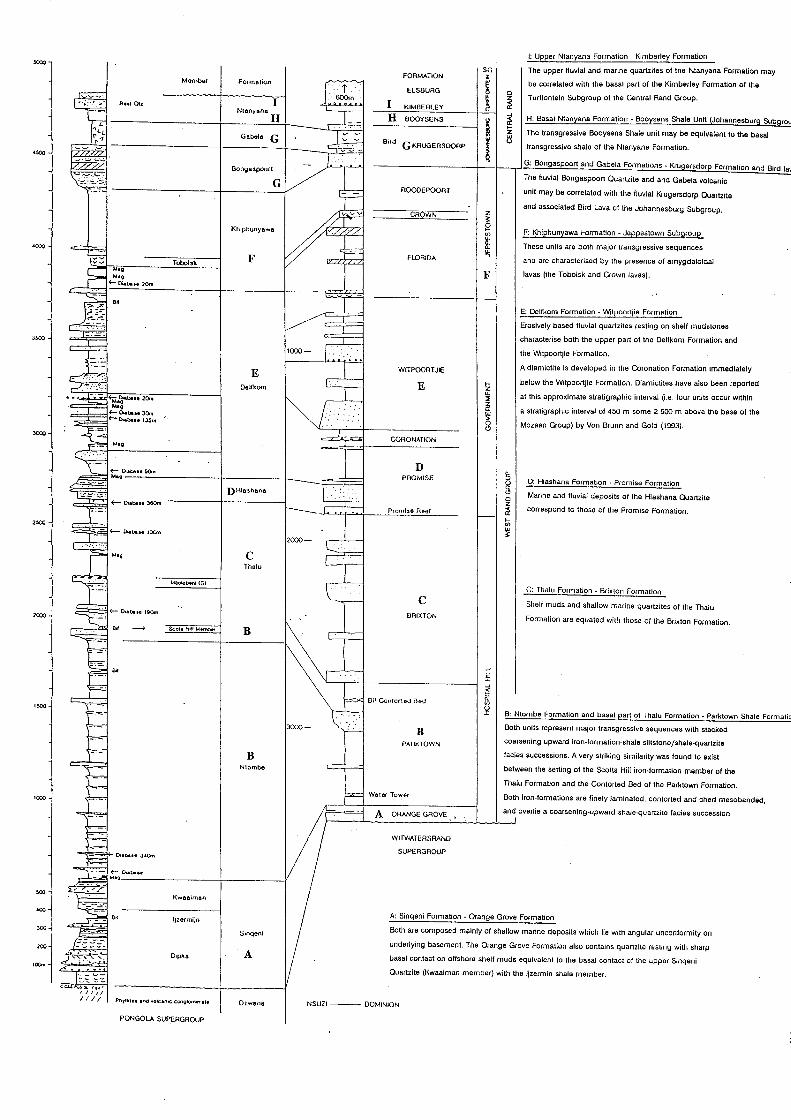
I: Upper Ntanyana Formation - Kimberley Formation
SG The upper fluvial and marine quartzites of the Ntanyana Formation may FORMATION • Momber fOfmelion
~ be correlated with the basal part of the Kimberley Formation of the ELSBURG D
Turffontein Subgroup of the Central Rand Group. I ~ ~ RulOU I KIMBERLEY Nleoyena H
H BOOYSENS
~ ~ H: Basal Ntanyana Formation - Booysens Shale Unit (Johannesbura Subarou ... The transgressive Booysens Shale unit may be equivalent to the basal z
Gebell! G Bird l ~
GKRUGERSDOAP transgressive shale of the Ntanyane Formation. '500
G: Bongaspoort and Gabela Formations - Kruge(sdor~ Formation and Bird la .. Bo""B>poorl The fluvial Bongaspoort Quartzite and and Gabela volcanic
._.- ROODEPOOnr unit may be correlated with the fluvial Krugersdorp Quartzite
z and associated Bird Lava of the Johannesburg Subgroup. CROWN
Khiphunyewa ~ F: Khiehun:tawa Formation - JeeEestown SubSlrouE VI
.0<>;) ~ These units are both major transgressive sequences
F FLORIDA and are characterised by the presence of amygdaloidal Tobol~k
F lavas (the Tobolsk and Crown lavas).
E: Delfkom Formation - Witpoortjie Formation
Erosively based fluvial quartzites resting on shelf mudstones
3500 characterise both the upper part of the Delfkom Formation and
the Witpoortjie Formation.
E WITPOORTJIE A diamictite is developed in the Coronation Formation immediately
below the Witpoortjie Formation. Diamictites have also been reported E ... Delfkom Z UJ at this approximate stratigraphic interval (Le. four units occur within :E
~ a stratigraphie interval of 450 m some 2 500 m above the base of the ~
JOOJ g Mozaan Group) by Von Brunn and Gold (1993).
CORONATION
D 5 PFlQMISE
0: Hlashana Formation ~ Promise Formation g DHle~heoa " Marine and fluvial deposits of the Hlashana Quartzite D z
Prorni~o AItOI ~ correspond to those of the Promise Formation. ... 2>00 '" ~
C Tholu
MoolObotoi (GI
C: Thalu Formation - Brixton Formation
C Shelf muds and shallow marine quartzites of the Thalu DRIXTON
Formation are equated with those of the Brixton Formation. SeOls Hill Membef B
~ ~ ~
~ 0,' Conlor1lKJ 000 "-
'" 1500 !1 B: Ntombe Formation and basal part of ThaJu Formation - Parktown Shale Formatia
B Both units represent major transgressive sequences with stacked
PAf*<10WN coarsening-upward iron-formation-shale-siltstone!shale-quartzite
B facies successions. A very striking similarity was found to exist
N10mbe between the setting of the Scotts Hill iron-formation member of the
Thalu Formation and the Contorted Bed of the Parktown Formation.
1000 Waler Towt1f Both iron-formations are finely laminated, contorted and chert mesobaoded,
A ORANGE GROVE and overlie a coarsening-upward shale-quartzite facies succession
WITWATERSRAND
Do.c. .. 340m SUPERGROUP
"'" KW88iman
<00 a, Ijzermijn A: Sinqeni Formation - Orange Grove Formation
300 Slnqoni Both are composed mainly of shallow marine deposits which lie with angular unconformity on
200 underlying basement. The Orange Grove Formation also contains quartzite resting with sharp Dlpka A basal contact 00 offshore shelf muds equivalent to the basal contact of the upper Sinqeni
100m .. _ ..... -- Quartzite (Kwaaiman member) with the Ijzermin shale member .
Pro)"tble •• rId "OIC.noc conglQm",..le OrwanB NSUZI--- DOMINION
PONGOl.A SUPERGROUP

150
When viewed on a broader scale, it is very likely that the two depositaries must have been
related in some way as the distance between the southernmost Witwatersrand Supergroup
outcrops and those of the Mozaan in the Amsterdam area is only around 110 km. Beukes and
Cairncross (1991) concluded that: "It seems highly unlikely that two such similar sequences
could develop independently, in approximately the same time interval. such a short distance
away from each other on the Kaapvaal Craton." Investigation regarding the Witwatersrand -
Pongola correlation continues and is the subject of a recently submitted PhD thesis at the Rand
Afrikaans University in Johannesburg (pers comm. N.J.Beukes, 1997).
Versfeld (1988) assumed the source of Au in the Nsuze Group conglomerates (e.g. at Patsoana)
to be the N ondweni greenstones, because the conglomerate clasts are dominated by greenstone
lithologies. The low grade of mineralisation was attributed to the immature, matrix supported
nature of the conglomerates which resulted in lower Au concentration factors.
5.1.3. Archaean Volcanogenic Massive Sulphide Deposits
The Toggekry Formation contains mineralisation that exhibits similar features to other
Archaean massive sulphide deposits and modern seafloor exhalative massive sulphide deposits
(Wilson and Versfeld, 1994a). The sulphide deposits (described in chapter 3) are hosted in
reworked felsic tuffs intercalated with sediments. The regional geologic setting envisaged is
one of extrusive felsic rocks in a basalt-dominated volcanic environment. As the Toggekry
Formation outcrops over a limited area, this eruptive event is attributed to the local
development of a major felsic eruptive centre (Versfeld, 1988), after which there was a return
to dominantly mafic and ultramafic magmatism. The final location of the mineralisation is
structurally controlled, e.g. in closures of folds.
Several similarities exist between these deposits and those of the Murchison greenstone belt
in the Northern Province of South Africa, which are also considered to be Archaean volcanic
exhalative type deposits (Taylor, 1981, cited in Maiden, 1984). These deposits are of limited
size and are confmed to a restricted zone within the Rubbervale Formation (Maiden, 1984).
The most significant of these, the Maranda J copper-zinc deposit, consists of a small « 1 Mt)
massive sulphide lens overlying a zone of stringer mineralisation. The Rubbervale Formation
quartz-sericite-chlorite schists have also been interpreted as metavolcanics (SACS, 1980) and
151
mineralisation has been attributed to hydrothermal activity which leached mineralisation from
the volcanic pile (Maiden, 1984).
5.2. THE PROTEROZOIC:NATAL METAMORPHIC PROVINCE
General
The Natal Metamorphic Province (NMP) has been described in detail in chapters two and four
of this work. In this section, an attempt is made to illustrate the various genetic types of
mineralisation in relation to the tectonic evolution of the NMP.
The NMP forms the Natal sector of the Mesoproterozoic (± 1.1 Ga) Namaqua-Natal
Metamorphic Province. The evolution of this high grade tectonic belt has been analyzed by
various workers in great detail (e.g. Matthews, 1972; 1990; Thomas and Eglington, 1990;
Jacobs et al. 1993; Jacobs and Thomas, 1994; Thomas et al. 1993a; 1994b; 1995b; Cornell et
al. 1996). From this research there is general consensus that the evolution of the belt can be
related to a complete Wilson Cycle model. This involved an initial phase of extension and
rifting that led to fragmentation and the formation of oceanic basins. This early phase was
followed by plate convergence, obduction and oblique collisional orogeny.
In the Natal sector, the Tugela Ocean is believed to have formed south of the Kaapvaal Craton,
with rising volcanic arcs (later to form the Mzumbe and Margate Terranes) further south (Fig.
5.8). The Tugela Terrane has been interpreted, by Matthews (1972), as an ophiolitic
assemblage that was deposited in this oceanic basin. Early northeast-directed thrusting and
nappe emplacement, believed to be due to oblique arc-continent collision associated with the
closure of the Tugela Ocean, led to the accretion of the three NMP terranes onto the southern
margin of the Kaapvaal Craton (Thomas et al., 1994b). _~ontinued convergence is thought to
have resulted in collision-induced crustal thickening and later ductile transcurrent shearing (see
section 2.2).
5.2.1. Mineralisation and Tectonic Evolution
Four genetic groups of metalliferous deposits have been recognised within the NMP (Thomas
et aI., 1994b). These are magmatic segregations, volcanogenic exhalative deposits, granite
related deposits and epigenetic precious metals. This metallogeny can be related to the various

152
stages in the tectonic evolution of the NMP. Detailed descriptions of the individual deposits
are given in chapter four.
Rifting and sea-floor spreading during the early stages of the development of the NMP (thought
to have begun at -1700 Ma by Thomas et ai., (1994b» are likely to have produced the
supracrustal sequences of the Tugela Terrane, which were originally interpreted, by Matthews
(1972), as an ophiolite assemblage formed in an oceanic basin to the south of the Kaapvaal
Craton. Studies based on events in the entire Namaqua-Natal Province, led Thomas et ai.,
(l994b) to suggest that volcanic arc activity may have been initiated at -1600 Ma, with arc
related magmatism occurring in back-arc basins between 1200 and 1300 Ma. Mineral deposits
associated with the back-arc basin environment include the volcanic exhalative sulphide
deposits (which are also found in the Areachap Terrane of the Namaqua sector) and deposits
formed as a result of alkali basalt volcanism due to hot-spot activity. Detailed discussions of
these deposits follow.
\ \
M1IJmb8
VI1IC'''IC AJC
B:tck·:lfe !p,~"dlno
Ton~lIlIc '""uSlvll! (Mrumbe Suh)
-130010 -1200 Ma
Fig. 5.8: Early stages in the development of the NMP terranes (after Cornell et aI., 1996).The southern margin of the craton is considered to have been a long-lived transform fault, that was initiated in the Late Archaean (Matthews, 1990).1t is also uncertain how much structural reworking occurred along the southern margin of the craton.

153
The NMP terranes were later defonned and metamorphosed during north-easterly directed
accretion onto the southern margin of the Kaapvaal Craton. Collision-related crustal thickening
is then thought to have resulted in the generation of syn- to late-tectonic granitic magmas.
Magmatic fluids emanating from these magmas at shallow crustal levels could have resulted
in the fonnation of pegmatites and epithennal vein deposits. Later isostatic adjustments of the
terranes may have reactivated major shear zones which provided the conduits for late
mineralising fluids which fonned precious metal vein deposits (Thomas et al., 1994b).
5.2.1.1. Magmatic Segregations
The Tugela Rand Layered Suite (TRLS) and Mambula Complex are considered to be the
products of alkali basalt magmatism due to hot-spot activity at - 1200 Ma (Wilson, 1990), i.e.
prior to the main phase of defonnation and metamorphism in the NMP. According to Eales et
al. (1988) the geochemistry of the TRLS magmas shows affinities to an alkali basalt with
emplacement occurring in an oceanic intraplate-type setting. The Fe-rich Mambula Complex
contains similar lithological and textural characteristics to the TRLS and is considered to be
a more evolved analogue that resulted from differentiation of a magma of similar overall
composition (Eales et aI., 1988). The TRLS contains small, irregular, low grade chromite ore
bodies. However, recent investigations revealed disseminated Cu, Ni and Co sulphides within
the lowennost pyroxenitic and peridotitic rocks (Thomas et aI., 1990a). The Mambula
Complex contains considerable amounts of Fe-Ti and V mineralisation.
The Sithilo and Sebenzani Complexes are thought to represent a segment of lower oceanic crust
that was emplaced along, or adjacent to, thrust zones during obduction of the northern margin
of the NMP onto the Kaapvaal craton (Matthews, 1972; Thomas et aI., 1990a). Although a
complete ophiolite sequence is not developed, Wuth and ~rcher (1986) considered the Sithilo
Complex to be a Precambrian equivalent of the alpine-type, ophiolitic, podifonn chromite
deposits such as those found in Turkey, Cyprus and the Phillippines. Initial concentration of
the chromite is attributed to primary magmatic differentiation within the oceanic crust which
initially localised and concentrated the mineralisation (Wuth and Archer, 1986). The minor Cu
Ni occurrences at Sebenzani are also associated with the thrust-related alpine-type serpentinites
(Thomas et al., 1994b).

154
5.2.1.2. Volcanogenic Exhalatives
Volcanogenic massive sulphide deposits found, for example, in Canada and Australia, are
significant producers of gold, silver and base metals (Hannington and Scott, 1989; Large et al.,
1989).
Volcanogenic exhalative activity in the arc-related environments in which the Tugela and
Mzumbe Terranes probably formed is thought to be responsible for the massive sulphide
deposits found in these terranes (Thomas et ai., 1994b)(Fig. 5.8). Evidence for volcanogenic
exhalative activity exists in the form of a submarine-exhalative massive sulphide deposit (the
i'Thuma massive sulphides - see section 4.1.2.1) in the Tugela Terrane (Thomas et aI., 1990a)
and a small (subeconomic) Besshi-type Cu- Zn rich volcanogenic massive sulphide body in
gneisses of the Quha Formation in the Lilani Valley (Thomas et aI., 1995b). Stratiform
tungsten deposits of possible volcanogenic origin (Scogings, 1984) are also reported from
northern KwaZulu-Natal in lithologies equated with the Quha Formation.
The origin of the Quha Formation has recently been the subject of a detailed investigation by
Cornell et al. (1996). Evidence points to the Quha Formation to have been formed near a back
arc spreading centre (Fig. 5.8) at -1300 Ma, which is broadly coeval with that of the
Copperton Formation in the Areachap Terrane of the Namaqua Province. The latter Terrane
was also thought to have formed in a similar environment. A similar structural history (both
were accreted onto stable cratonic regions) (Jacobs et aI., 1993), as well as lithological and
mineralogical similarities are found between the two formations. The Areachap Group has been
extensively explored and was found to host two economic Zn-Cu deposits, which were mined,
and several other subeconomic prospects.
Although no detailed prospecting has been reported from KwaZulu-Natal, Cornell et al. (1996)
report the presence of garnetiferous quartzites or coticules, containing elevatedCu, Ni and Mo
values, within the gneisses of the Quha Formation. These coticules are considered to have been
formed as cherty chemical sediments in a volcanic-exhalative environment, and may point to
the presence of ore-forming environments within the Quha Formation. Cornell et al. (1996)
considered it likely that Besshi-type massive sulphide Cu-Zn deposits could be present in the
back-arc basin environment where the Quha gneisses originated.-

155
Submarine volcanogenic activity associated with mineral deposit formation on the modem
ocean floor can provide important clues as to mineralisation within the ancient terranes (such
as the NMP), as they are thought to be products of the same geological and geochemical
processes. The following discussion is based on current studies of modem ore-forming
processes on the sea floor in various tectonic settings (e.g. mid-ocean ridges and back-arc rifts)
as reviewed by Herzig and Hannington (1995), Hannington and Scott (1989) and Large et al.
(1989).
In an analogous situation to the early stages of the formation of the NMP terranes, modem
sulphide formation within spreading centres in back-arc basins formed volcanic-hosted and
sediment -hosted deposits as a consequence of seawater circulation in the volcanic basement.
The heat source related to the formation of these deposits includes submarine volcanoes
occurring along or close to the axis of oceanic rift zones and intraplate hot-spots and island-arc
related seamounts.
Almost identical ore-forming processes are found to occur within various tectonic settings.
However, the composition of the underlying volcanic rocks, which vary from mid-ocean ridge
basalts to calc-alkaline felsic lavas (such as andesites and rhyolites) causes major variations in
the mineral compositions and metal-enrichments in the sulphide deposits formed. According
to Herzig and Hannington (1995), polymetallic sulphide mineralisation forming in back-arc
environments commonly contains sphalerite as the dominant sulphide, while visible primary
gold has also been documented in low-temperature white smoker chimneys from this
environment. These environments also contain elevated Ag, Cu and Ba element concentrations,
when compared to deposits forming at some mid-ocean ridge deposits.
Ultimately, the concentration of minerals in specific deposits will depend on source-rock
geochemistry, which controls the composition of the hydrothermal fluids and their ability to
carry gold (Herzig and Hannington, 1995). Other factors, such as temperature, pH and oxygen
fugacity control the mineralogical associations in the fluids. Large et al. (1989) concluded that
a gold-copper association reflects Au being mobilised as a AuCI2- complex from high
temperature (above 300°C), low pH ( < 4.5), moderate to highj02' high salinity fluids, while
the gold-zinc association implies Au transport as the Au(HS)2- complex from lower temperature

156
(200-250°C), moderate pH (4.5-6), and moderatej02 fluids. These associations may be present
within different zones within the same deposit, e.g. at i'Thuma, where the Au-Zn association
occurs in the upper parts of the deposit, while the footwall stringer zone is characterised by
the Au-eu association (Thomas et aI., 1990a).
A typical modern seafloor sulphide deposit is shown in Fig. 5.9. According to Herzig and
Hannington (1995), these typically consist of a consolidated basal sulphide mound which
.. :..."
·.:EC-;'L LE.~CHIIJG S r:oCSr<->H 2S
--------- Icor.l ---------
ANK-(t)RITE ·-'·'·CONE
~.;:~:::: .:. ~:\:~.-.-
\ ~ \
350'C CEUTF'AL
;>
250' ·3QC·C WHITE S;,IOK::"5
./ GRADAnONALCONTACT
./
FE·RICH CHLORITIC CORE SILICIFIED STOCK':IORK II.IG-RICH AT r.1AF'G!N)
ILLITE:: sr.IECTiTE
/
FC:TE·/TIAl SOURCE REGION FOR r.IUL TIPlE SEJ-FLCOR H'fDROTHE',IAl S'(STEr"s
OUTE~ ZSNE ''<:.1
- - -- -LC'.'j PERr,IE~BllIr(
~OOC HIGH-TE'.IF' c;E~C-;C'J Z::':E AT TOP OF SUBAX:.~L '.L~C.:':'
IPOSSIBlE SUBSEAFlCOP ACUIF::",
Fig. 4.9: Cross-section of a modem seafloor hydrothermal system, showing the principal components (after Herzig and Hannington, 1995),

157
overlies a sub-seafloor stockwork. Abundant chimney structures (high-temperature black
smokers and lower-temperature white smokers), hydrothermal crusts, metalliferous sediments
and accumulations of sulphide talus and debris occur in the upper parts of the deposit.
Hydrothermal fluids circulating through the sulphide pile increase the size of the mound. and
causes recrystallisation of the sulphide minerals.
5.2. 1 .3. Granite-related Deposits
5.2.1.3.1. Alkaline Granites
Sub-economic enrichments of REE, Zr, Nb and Y occur within peralkaline granitic gneisses
and carbonatites within the Tugela Terrane (Thomas et aI., 1994b). Limited hot-spot activity
in the Tugela Ocean led to localised tensional tectonics and resulted in the production of
peralkaline granitoids and associated mineralisation (Thomas et aI., 1990a). Scogings (1989a)
interpreted the peralkaline siliceous gneisses with anomalous REE, Zr, Nb and Zn
concentrations, to be magmatically concentrated cumulate layers.
These granites were generated immediately to the south of the Kaapvaal Craton margin in an
anorogenic tectonic environment (Scogings, 1986), and were thrusted northward during
obduction. This alkaline-type mineralisation is confmed to the lowermost structural unit of the
nappe zone, the Nkomo Nappe.
5.2.1.3.2. Li-bearing Pegmatites
The only economically important pegmatites yet discovered within the NMP are intrusive into
the high-grade mafic gneisses of the Mucklebraes Formation (Margate Terrane). These
spodumene-rich, leucocratic pegmatites are thought to represent late-stage differentiates of the
anhydrous garnet leucogranites and charnockites of the s~!ltectonic Margate Granite Suite, and
crystallised from relatively high-temperature, volatile-poor liquids under conditions of low
.!H20 and low J02 (Thomas et aI., 1995b). The lithium is considered to have been scavenged
from Li-enriched metasediments of the Margate Terrane during anatexis. The pegmatites
crystallised primary petalite which formed symplectic spodumene-quartz intergrowths on near
isobaric cooling (Thomas et al., 1994a).

158
5.2.1.4. Epigenetic Deposits
Epigenetic, quartz vein-hosted gold occurrences have been located within the greenschist facies
Tugela Terrane and amphibolite facies Mzumbe Terrane. The final location of the
mineralisation in all occurrences is structurally controlled due to the northeast -directed
thrusting events, being disseminated in sheared host lithologies and quartz-sulphide vein
arrays. Final deposition of the mineralisation thus occurred late in the structural history of the
NMP. High grades of metamorphism, due to the intrusion of abundant granitoids in the
Mzumbe and Margate Terranes, are considered to have had a detrimental effect on the
concentration of mineralisation in the southern parts of the NMP (Thomas et al., 1990a).
The shear-zone-related precious metals in the Tugela Terrane may have been derived from a
number of possible sources (Thomas et aI., 1990a; 1994b). As the schistose host rocks
represent metalavas and passive margin-type sediments that were deposited in the oceanic basin
(Tugela Ocean) close to the southern margin of the Kaapvaal Craton, local volcanogenic
exhalative processes and the voluminous basic metalavas constitute possible original source
rocks for the mineralisation. In addition, the greenstones of the Kaapvaal Craton which
underlie the thrust front are thought to be another possible source of gold. Seawater and fluids
derived from metamorphic dewatering may have then leached the precious metals from the
source rocks before being transported along syntectonic thrust planes during obduction
(Thomas et aI., 1990a).
Mineralisation in the arc-related Mzumbe Terrane is hosted in amphibolite grade felsic
(probably acid volcanic) gneisses of the Ndonyane Formation and associated syntectonic
granite gneisses of the Mzimlilo Suite (Thomas and Gain, 1989). The gold in this terrane was
mobilized during the NMP accretionary event and concentrated in the shear zones under
favourable precipitation conditions (as discussed for the lode gold deposits). The source of the
gold in the Mzumbe Terrane is postulated to be the acid igneous gneisses. Mineralisation is
associated with sulphides and appears disseminated in the sheared host rocks and in en echelon
quartz vein arrays that developed within wide, sinistral transcurrent shear zones associated with
the major Jolivet Shear.

159
CHAPTER SIX
6. SUMMARY AND CONCLUSIONS
The mineral deposits within the study area occur in host rocks that range in age from Archaean
to Recent. Only the Precambrian deposits have been analyzed as these are most interesting from
a metallogenic point of view.
Various styles of mineralisation occur in the study area. The genesis of the mineralisation is
generally consistent with models proposed for the evolution of the host terranes. In some cases,
the different terranes were found to host similar styles of mineralisation, but with widely varying
ages in the mineralising episodes. The - 3.6 Ga Archaean granite-greenstone terranes for example,
contain structurally-hosted lode-gold mineralisation, in common with the Late Archaean (- 3 Ga)
Pongola Supergroup and the (- 1.1 Ga) Natal Metamorphic Province (NMP). Volcanogenic
massive sulphides are also found in the Archaean Nondweni Group and the NMP. Similar
processes are evoked for the formation of the deposits although the host rocks and tectonic
evolution paths of the different terranes vary.
A brief summary of the most important genetic types of mineralisation in the various terranes is
provided here, to give the reader a broad overview of the Precambrian metallogeny of K waZulu
Natal. A discussion of the mineral potential of KwaZulu-Natal and a short overview of the benefits
of metallogenic mapping follows.
6.1. The Granite-Greenstone Terrane
Numerous small gold deposits have been worked from the Archaean greenstones that outcrop in
northern K waZulu-N atai. These contain many characteristics common to lode-gold deposits found
in Archaean granite-greenstone terranes in other parts of the world. The deposits are considered
to be intimately linked to nearby late-tectonic intrusive bodies. Accerding to Versfeld (1988) and
Bullen (1991), these intrusives are thought to have provided the heat source and created the
structures necessary for the passage of deeply-sourced auriferous fluids. These fluids then
160
deposited Au in structurally and lithologically favourable sites. The number and size of mineral
deposits in individual terranes is largely considered to be related to the efficiency of this
mineralising system.
The Nondweni greenstones also contain volcanic-related massive sulphide deposits rich in Cu-Zn
mineralisation. These were formed due to localised sub-aqueous felsic eruptive centres during the
evolution of the greenstones. The original deposits were then deformed and are now structurally
hosted.
6.2. The Pongola Supergroup
6.2. 1. Placer Deposits
Showings of gold mineralisation within conglomerates of the Pongola Supergroup have been
known since the early parts of the century, however no significant economic mineralisation is
evident as yet. The Pongola basin and richly mineralised Witwatersrand basin are of similar age
and lie in close-proximity on the Kaapvaal craton, which would suggest that potential rich placer
deposits may exist.
6.2.2. Lode Gold Deposits
The only working gold mine in KwaZulu-Natal is hosted by the metasediments of the Mozaan
Group of the Pongola Supergroup. Numerous other small prospects have also been investigated
in the vicinity. These deposits are hosted mainly in quartz veins and show characteristics typical
of mesothermal gold deposits. The mineralisation is located adjacent to major structural
discontinuities and probably formed under similar conditions to the lode gold deposits found in
the granite-greenstones.
6.3. The Natal Metamorphic Province
This high-grade tectonomorphic terrane is host to numerous types of mineralisation. The Tugela
Terrane in the north contains most of the mineralisation, while- the terranes to the south (the
Mzumbe and Margate Terranes) are relatively poorly mineralised. Thevarious genetic types of
161
mineralisation correspond to the tectonic evolution model proposed for the NMP (Thomas et al.,
1990a). Parts of the Tugela Terrane have been interpreted as an ophiolite complex that
accumulated in an oceanic basin to the south of the Kaapvaal craton. This oceanic basin was
subject to rifting, sea-floor spreading and limited hot-spot activity. The Mzumbe and Margate
terranes have been interpreted as volcanic arcs that developed in response to subduction of the
Tugela Ocean. The final location of all the mineralisation within the NMP is structurally
controlled, as the terranes have been intensely deformed after their formation.
6.3. 1. Magmatic Segregation Deposits and Ophiolites
Hot-spot activity in the Tugela Ocean gave rise to alkali basalt magmatism which formed the
Tugela Rand and Marnbula intrusive complexes. Obduction of the Tugela ophiolites due to north
directed thrusting was accompanied by the emplacement of mineralised alpine-type serpentinites
(Sithilo and Sebenzani Complexes) along major structural discontinuities.
6.3.2. Volcanogenic Exhalations
Volcanic-arc activity in back-arc basins gave rise to the volcanic exhalative sulphide deposits of
the Tugela and Mzumbe Terranes. According to Thomas et al. (1990a), limited sea-floor spreading
in the Tugela Ocean gave rise to tholeiitic lavas. Volcanogenic exhalations on the ocean floor close
to spreading centres then probably gave rise to the i'Thuma massive to semi-massive sulphide
mineralisation. The mineralisation was then thrust northward during the obduction episode to its
present location.
The Quha Formation of the Mzumbe Terrane also shows evidence of volcanic exhalative processes
and is considered to host Besshi-type massive sulphide Cu-Zn mineralisation. The back-arc basin
environment in which the Quha Formation gneisses are. considered to have formed and the
presence of siliceous coticule point to potential base metal mineralisation. Similarities between the
Quha Formation and the Copperton Formation in the Namaqua Metamorphic Province, which has
been extensively explored and contains many mineralised prospects, may also encourage further
exploration in KwaZulu-Natal.

162
6.3.3. Granite-related Deposits
These consist of peraikaline granitoids which fonned in an anorogenic environment in the Tugela
Terrane and pegmatite deposits that are related to the collision event. These granitoids contain
magmatic ally concentrated cumulate layers enriched in REE, Zr, Nb and Zn. The rocks were
obducted onto the craton and are confined to the lowermost nappe structure.
Spodumene-rich pegmatites derived from the syntectonic Margate Granite Suite contain economic
quantities of lithium. Anatectic melting of country rocks rich in lithium are proposed to be the
source of the metal.
6.3.4. Epigenetic Deposits
Epigenetic, lode gold deposits related to shear zones occur in the Mzumbe and Margate Terranes.
The source of metals in the Tugela Terrane have been attributed to the host basic metalavas and
underlying greenstone remnants of the Kaapvaal Craton. Interaction with seawater and fluids
derived from metamorphic dewatering resulted in leaching of precious metals from the source
rocks. These fluids were then carried to their depositional sites by thrusting during obduction.
The gold in the Mzumbe Terrane was likely to have been derived from acid igneous intrusives and
concentrated in favourable lithological and structural sites by metamorphic and magmatic fluids
during defonnation.
6.4 THE MINERAL POTENTIAL OF KWAZULU-NATAL
Vast areas of this Province remain unexplored for various reasons, including poor outcrop, deep
weathering, inaccessible terrane, population density and poor infrastructure. The following
discussion considers areas already known to have mineralisation, and possible extensions to these
deposits. The economically important heavy mineral sands deposits are also mentioned.
* The terranes to the north have abundant potential with regards to gold mineralisation.
An ore genesis model proposed by Bullen (1990) for the Melmoth granite greenstones revealed

163
that other small, shear zone-hosted Au deposits may exist in this remnant and other greenstone
inliers in northern KwaZulu-Natal. He suggested that the major shear zone with which these
deposits are associated is of considerable extent and should be delineated (westwards) by means
of drilling and geophysical methods, in order to locate other shear zones of the same age as those
which host the mineralisation. Further, the older workings in the area should be sampled for
extensions to the mineralisation at depth. Smaller deposits that still contain mineralisation may
prove viable only for small-scale exploitation by private entrepreneurs.
* Many quartz vein hosted prospects in Pongola metasediments have potential for small-scale
exploitation. Many of these were sampled by mining companies and found to be uneconomic.
However, small-scale exploitation may prove to be viable. In addition, the Klipwal gold mine,
which exploits shear zone-hosted gold within the Mozaan Group metasediments, is currently the
only working gold mine in KwaZulu-Natal.
* Ongoing research with regards to the Witwatersrand - Pongola lithological correlations are also
interesting and some target areas may prove to be of more than academic importance. Recently
Beukes and Cairncross (1991) provided detailed correlations of the Mozaan Group and
Witwatersrand Supergroup, which contains highly economic placer gold deposits, and found many
lithostratigraphic and palaeoenvironmental similarities. These workers suggested that the
stratigraphically higher lithologies should be targeted for further economic studies.
* Significant portions of the Natal Metamorphic Province remain unexplored with respect to
mineralisation. The Tugela Terrane of the NMP may contain additional massive sulphide deposits
similar to those found at i'Thuma. From the proposed tectonic evolution model, there is a
possibility that the volcanogenic processes likely to have f~rmed the i'Thuma deposit may have
occurred at similar stratigraphic levels and should be examined. The Quha Formation of the
Mzumbe Terrane also shows evidence of exhalative processes and should be a target for further
exploration. Recent prospecting activity in the Lilani Valley, reported by Thomas et al. (1995b),
revealed a sub-economic Zn-rich massive sulphide deposit in the highly deformed gneisses. Other
164
potential deposits may exist under younger cover. However, these deposits could also have been
removed to some extent by erosion or appear to be of limited extent due to extreme structural
reworking in some areas.
The NMP terranes contain numerous major structural discontinuities resulting from obduction and
thrusting. As most of the mineralisation is structurally controlled, these structures may be host to
further mineralisation.
These thrust and shear zones formed channels for the migration of metalliferous fluids from depth,
and also for the emplacement of mineralised, alpine-type ultramafic intrusives (Thomas et al.,
1990a). Layered intrusions such as the Mambula Complex and Tugela Rand Layered Suite were
formed before being thrusted and emplaced at their present locations in the nappe zone. The lower
parts of these intrusions may possibly be preserved in other areas within the nappe zone.
* The gold deposits of the Mzumbe Terrane (Urnzinto Goldfield) are also considered to have
further potential as only a relatively small portion of the shear zone hosting the mineralisation has
been explored along strike (Thomas and Gain, 1989). In addition, the poorly exposed Melville
Thrust is considered to have potential with regards to metalliferous mineralisation (Thomas et al.,
1990a).
* Industrial mineral deposits within the NMP comprise the important Marble Delta limestone
deposits in the Margate Terrane, which contains considerable reserves of lime to supply the
country's needs for the foreseeable future. Dolomites of the Ntingwe Group of the Tugela Terrane
may represent a future resource of lime for local farming projects, while the extensive talc deposits
may have potential in the fillers market (Bullen et al., 1992). In addition, the Bull's Run and
N goye Complexes have abundant reserves of nepheline and feldspar for use in the glass-making
industry.
Industrial mineral deposits derived from these older lithologies also provide considerable

165
exploitation potential. Weathered Proterozoic granites of the Mzumbe Terrane have been
investigated for their kaolin potential with favourable results. Vast quantities of eluvial feldspar
associated with weathered Oribi Gorge Suite Granites are also potentially important (Bullen et al. ,
1992).
* The most economically exploited mineral deposits currently mined are the heavy mineral sands
deposits that occur along the KwaZulu-Natal coastline in the vicinity of Richards Bay in the north.
These sands, hosted in lithologies of Recent age, contain economic concentrations of rutile,
ilmenite and zircon, from which titanium and zirconium are extracted. Pig iron is a useful
byproduct from this operation. The geology and mineralisation of these deposits has been analyzed
in Fockema (1986) and Hugo (1993). The mineralisation was found to be derived from many of
the older lithologies that are found inland, such as the Karoo dolerites, NMP and the Archaean
granite-greenstones, volcanics and sediments. The entire coastline of KwaZulu-Natal is known to
contain potential heavy mineral sands deposits.
Further geological research and exploration is required in KwaZulu-Natal to refme the basic
theories that already exist. The numerous, albeit small, precious metal deposits (many of which
were discovered and worked in the early part of the century) found in the Province certainly points
to a mineralised system that was active in the various host terranes. A dedicated exploration
programme using every available modem exploration technique will surely mean more economic
precious metal discoveries in KwaZulu-Natal.
6.5. THE BENEFITS OF METALLOGENIC MAPPING
Metallogenic maps provide concise information on the mineralisation and depositional -
environments of the host lithologies in the areas under investigation. Documentation of the field
characteristics of various deposits enables possible genetic interpretations of the host terranes to
aid in the exploration of potential mineralisation in analogous environments. However, even if
genetic interpretations prove to be incorrect, metallogenic maps contain the known characteristics

166
of the mineralisation under investigation and provides a basis for further investigations.
The maps are also useful for land-use information, in that potential areas are not sterilized before
exploitation. With the advent of the ORACLE programme, these maps can now be digitally
enhanced and customised, and also produced in digital format. Maps may be produced on various
scales and specific requirements are easily catered for. However, all the information must first be
compiled using the basic metallogenic mapping function, which is documentation of observed
geological characteristics.

167
7. Acknowledgements
I am grateful to the Council for Geoscience (Geological Survey of South Africa) for permission
to undertake the M.Sc (Economic Geology) course at Rhodes University in Grahamstown. Mr.
W. Bullen is thanked for initiating the project and for his advice during field visits. Dr. E.C.I.
Hammerbeck and Mr. M. Wilson are acknowledged for allowing me the time to pursue my further
studies. Mr. M. Wilson is also thanked for editing various parts of this work.
I would also like to thank my colleagues at the Council for their encouragement and good wishes
during my studies. Matt du Toit is especially thanked for his advice and interest in the project.
Discussions with Digby Gold, Bob Thomas and Bruce Eglington were also very valuable.
Professor J. Moore is acknowledged for his time and valued criticism of the initial drafts of the
thesis. My fellow M.Sc students, in particular John Astrup and Yasar Daglioglu, are thanked for
their companionship and support. Members of staff at the Geology Department, Rhodes
University, are thanked for their friendliness and good wishes.
The final draft of the thesis was completed while I was in the employ of West Rand Consolidated
Mines, who have also greatly contributed to the costs involved with this study. Dr. N.V.
Armstrong, in particular, is thanked for his interest in the project and for injecting new life into
exploration in KwaZulu-Natal.
My parents Gangaram and Indira, and sister Kirthi, are thanked for their love and support
throughout my life. To my Dad, a special Thank You for giving me all the opportunities,
educational and otherwise, that you did not have. To my wife Daksha, your love, patience,
understanding and encouragement during the various stages of this thesis is greatly appreciated.

168
REFERENCES
Adie, R.J. (1952). The position of the Falkland Islands in a reconstruction of Gondwana. Geol. Mag., 89, 401-410.
Andreoli, M.A.G. and Hart, R.J. (1985). Mineral potential of the Braemar Area, southern Natal. Rep. (unpubl). Geol. Surv. S. Afr. 1985-1092.
Anglo American Prospecting Services Final Report. (1992). Mambulu Igneous Complex. Ref: 131173/5050/92/235. Submitted to Geol. Surv. S.Afr. Unpubl. Rep., 1992-0115, 4pp.
Armstrong, N .V., Hunter, D.R. and Wilson, A.H. (1982). Stratigraphy and petrology of the Archaean Nsuze Group, northern Natal and southeastern Transvaal, South Africa. Precamb. Res., 19,75-107.
Armstrong, N.V., Wilson, A.H. and Hunter, D.R. (1986). The Nsuze Group, Pongola Sequence, South Africa: Geochemical evidence for Archaean volcanism in a continental setting. Precamrian. Res., 34, 175-203.
Barkhuizen, J.G. and Matthews, P.E. (1990). Gravity modelling of the Natal thrust-front: A mid-Proterozoic crustal suture in southeastern Africa. Ext. Abstr. Geocongress '90, Geol. Soc. S. Afr., Cape Town, 32-35.
Bekker, P.G. (1982). Natal Granite Quarries south-west of Port Shepstone. Rep. (unpub!'), South African Development Trust, 1669, 3 pp.
Bekker, P.G. (1985a). Bomela Gold. Rep. (unpubl.) South African Development Trust, 2195,4 pp. 1991-0040
Bekker, P.G. (1985b). Southern Kwazulu (Kwa-Xolo) Graphite Prospect. Rep. (unpubl.) South African Development Trust, 2197, 8 pp.
Bekker, P.G. (1986). Southern Kwazulu gold. Rep. (unpubl.) South African Development Trust, 2234, 8 pp. 1991-0044
Beukes, N.J. and Cairncross, B. (1991). A lithologic-~edimentological reference profile for the Late Archaean Mozaan Group, Pongola -Sequence: application to sequence stratigraphy and correlation with the Witwatersrand Supergroup. S. Afr. Joum. Geo!., 94,44-69.
Blain, M.R., Coetzee, c.B. and Lombaard, B.V. (1976). Andalusite-, Sillimanite and Kyanite, 255-260. In: Coetzee, C.B. (Ed.), Mineral Resources of the Republic of South Africa, Handbook 7. Government Printer, Pretoria, 462pp.
Bonnemaison, M. and Marcoux, E. (1990). Auriferous mineralisation in some shear-zones: A three-stage model of metallogenesis. Mineral. Deposita, 25, 96-104.
169
Brown, G.J. (1988a). Ngubevu Zinc, Msinga, KwaZulu. Rep. (unpub1.), South African Development Trust, 2543, 18 pp.
Brown, G.J. (1988b). Goodricke's gold, Kwazulu - Nondweni Sequence. Rep. (unpub1.), South African Development Trust, 2611, 6 pp.
Brown, G.J. (1989). Bongas Poort Gold. Rep. (unpubl.), South African Development Trust, 2664, 12pp.
Bullen, W.D. (1990). Gold mineralization in an Archaean granite-greenstone remnant west of Melmoth, Natal: Ore genesis and implications for exploration. M.Sc Thesis (unpubl.). Rhodes Univ. Grahamstown, 117 pp.
Bullen, W.D. (1991). Exploration model for Archean gold in Natal, South Africa. In: Ladeira, E.A. (Ed.), Brazil Gold '91 - The Economics, Geology, geochemistry and Genesis of Gold Deposits. A.A. Balkema, Rotterdam, 773-780.
Bullen, W.D., Thomas, RJ., and Scogings, A.J. (1992). The geological setting of industrial mineral deposits in the Natal Metamorphic Province. S. Afr. J. Geo!., 95, 51-59.
Bullen, W.D., Thomas, RJ., and McKenzie, A. (1994). Gold Mineralization in Natal, South Africa. Journ. Afr. Earth. Sci, 18, 99-104.
Burrows, D.R, Wood, P.C. and Spooner, E.T.C. (1986). Carbon isotope evidence for a magmatic origin for Archaean gold-quartz vein ore deposits. Nature, 321, 851-854.
Burt, M.W. (1977). Final Report on the Umlazi Nickel Project. Rep. (unpub!.), South African Development Trust, 720, 14 pp.
Burke, K., Kidd, W.S.F., and Kusky, T.M. (1985). The Pongola structure of southeastern Africa: The World's oldest preserved rift? Journ. Geodynamics, 2, 35-49.
Button, A. (1981). The Pongola Supergroup, 501-510. In: D.R Hunter (Ed.), Precambrian of the Southern Hemisphere. Elsevier, Amsterdam, 882 pp.
Cain, A.C. (1975). A preliminary review of the stratigraphic relationships and distribution of metamorphism in the northern part of the Natal-Namaquarides, South Africa. Geo!. Rundschau, 64, 192-215.
Card, K.D., Poulsen, K.H. and Robert, F. (1989). The Archaean Superior Province of the Canadian Shield and Its Lode Gold Deposits. Econ. Geology. Monograph, 6, 19-36.
Cameron, E.M. (1988). Archaean gold: Relation to granulite fonnation and redox zoning in the crust. Geology, 16, 109-112.

170
Charlesworth, E.G. (1981). Tectonics and metamorphism of the northern margin of the Namaqua Natal Mobile Belt near Eshowe, Natal. Ph.D thesis (unpubl.), Univ. Natal, Durban, 433pp.
Cole, E.G. and Beukes, N.l. (1995). Lithostratigraphy of the Archaean Nsuze Group of the Pongola Supergroup in South Africa and swaziland. Ext. Abst., Centenial Geocongress, Rand Afrikaans University, 817-819.
Colvine, A.C., Fyon, l.A., Heather, K.B., Marmont, S., Smith, P.M. and Troop, D.G. (1988). Archaean lode gold deposits in Ontario. Ontario Geol. Surv Misc. Paper 139, 136 pp.
Compston, W. and Kroner, A. (1988). Multiple zircon growth within early Archaean tonalitic gneiss from the Ancient Gneiss Complex, Swaziland. Earth Planet. Sci. Lett., 87, 13-28.
Cornell, D.H., Thomas, Rl., Bowring, S.A., Armstrong, RA and Grantham, G.H. (1996). Protolith interpretation in metamorphic terranes: a back-arc environment with Besshitype base metal potential for the Quha Formation, Natal Province, South Africa. Precambrian. Res., 77, 243-271.
Corner, B., Durrheim, Rl. and Nicolaysen, L.O. (1990). Relationships between the Witwatersrand within the tectonic framework of the Kaapvaal Craton as interpreted from regional gravity and aeromagnetic data. Tectonophysics, 171, 49-61.
De Beer, l.H. and Meyer, R. (1984). Geophysical characteristics of the Namaqua-Natal belt and its boundaries, South Africa. lourn. Geodynamics, 1, 473-494.
De Klerk, J.D. (1987). Sisters Mine Gold, KwaZulu. Rep. (unpubl.), South African Development Trust, 2405, 20 pp.
De Klerk, J.D. (1991). The nature and origin of gold mineralization in the Tugela Valley: Natal structural and Metamorphic Province. Unpubl. M.Sc. thesis, Rhodes University, Grahamstown, 113 pp.
De Wit, M.J. and Roering, C. (1990). Episodes of formation and stabilisation of the Kaapvaal Craton in the Archaean: an overview bas.~d on some selected recent data. Ext. Abstr, Limpopo Field Workshop, Rand Afrikaans Univ., Johannesburg, 42-52.
De Wit, M.J., Roering, C., Hart, R.J., Armstrong, A., De Ronde, C.E.J., Green; RW.E., Tredoux, M., Peberdy, E. and Hart, RA. (1992). Formation of an Archaean continent. Nature, 357, 553-562.
Dix, O.R (1984). Early Proterozoic braided stream, shelf and tidal deposition in the Pongola Sequence, Zululand. Trans. Geo!. Soc. S. Afr., 87, 1-10.

171
Du Preez, J.W. (1976). Mineral occurrences in Kwazulu. Unpubl. Rep., Geol. Surv. S. Afr., 1976-0017, 8 pp.
Du Toit, A.L. (1918). Plumasite (corundum-aplite) and titaniferous magnetite rocks from Natal. Trans. Geol. Soc. S. Afr., 21, 53-72.
Du Toit, A.L. (1920). The geology of Pondoland and portions of Alfred and lower Urnzimkulu Counties, Natal. Explan. Sheet, 28, (Pondoland), Geol. Surv. S. Afr., 44 pp.
Du Toit, A.L. (1931). The geology of the country surrounding Nkandla, Natal. Expl. sheet 109 (Nkandla). Geol. Surv. S. Afr., 105 pp.
Du Toit, A.L. (1946). The geology of parts of Pondoland, East Griqualand and Natal. Expl. Sheet 119 (Port Shepstone). Geol. Surv. S. Afr., 32pp.
Eales, H.V., Wilson, A.H. and Reynolds, l.M. (1988). Complex unmixed spinels in layered intrusions within an obducted ophiolite in the Natal-Namaqua mobile belt. Mineral. Deposita, 23, 150-157.
Eisenlohr, B.N., Groves, D.l. and Partington, G.A. (1989). Crustal scale shear zones and their significance to Archaean gold mineralisationin Western Australia. Mineral. Depos., 24, 1-8.
Eglington, B.M. (1987). Field, geochemical and isotopic studies of selected areas of Proterozoic crust in south-central Natal. Ph.D. thesis (Unpubl.), Univ. Natal, Durban, 373pp.
Eglington, B.M. and Kerr, A. (1989). Rb-Sr and Pb-Pb geochronology of Proterozoic intrusions from the Scottburgh area of southern Natal. S. Afr. J. Geol., 92,400-409.
Eglington, B.M., Harmer, RE. and Kerr, A. (1986). Petrographic, Rb-Sr isotope and geochemical characteristics of intrusive granitoids from the Port Edward-Port Shepstone area, Natal. Trans. Geol. Soc. S. Afr., 86, 199-213.
Eglington, B.M., Harmer, RE. and Kerr, A. (1989). Isotope and geochemical constraints on Proterozoic crustal evolution in south-eastern Africa. Precambrian Res., 45, 159-174.
Eglington, B.M., Thomas, R.J. and Evans, M.J. (1991). Humberdale Granite. In: M.R Johnson, (Ed.), Catalogue of South African Lithostratigraphic Units. S. Afr. Comm. Strat. 3, 15-16. .
Evans, M.J. (1984). Precambrian geology west of Scottburgh, Natal. M.Sc. thesis (unpubl.) Univ. Natal, Durban, 158 pp.

172
Evans, M.J. (1988). Prospecting on a portion of Reserve 21, Eshowe; KwaZulu - Rebellion Reef area (Phelps Dodge). Rep. (unpubl.), South African Development Trust, 2518, 12 pp.
Evans, M.J., Eglington, B.M., Kerr, A. and Saggerson, E.P. (1987). The geology of the Proterozoic rocks around Umzinto, southern Natal, South Africa. S. Afr. J. Geol., 90, 471-488.
Evans, M.J., Eglington, B.M., Thomas, R.J. and Linstrom, W. (1991). Sezela Suite. In: M.R. Johnson, (Ed.), Catalogue of South African Lithostratigraphic Units. S. Afr. Comm. Strat. 3, 45-46.
Fockema, P.D. (1986). Heavy mineral sands north of Richards Bay, 2301-2307. In: Anhaeusser, C.R & Maske, S. (Eds.), Mineral Deposits of Southern Africa, II, Geol. Soc. S.Afr., Johannesburg, 2335pp.
Fyfe, W.S. and Kerrich, R (1984). Gold: Natural concentration processes. In: Foster (Ed.), Gold '82: The Geology, Geochemistry and Genesis of Gold Deposits, Geological Society of Zimbabwe. A.A. Balkema, Rotterdam, 753 pp.
Gain, S.B. (1986). The Jolivet Shear Zone (Gold). KwaZulu-STK Evaluation Committee Rep. (unpubl.) M4/86, 88-91.
Germiquet, J.D. (1986a). The industrial mineral potential of the Bull's Run Syenite Complex northwest of Eshowe, Kwazulu. Rep. (unpubl.), South African Development Trust, 2312, 8 pp.
Germiquet, J.D. (1986b). Preliminary cost study for the production of nepheline syenite from the Bull's Run Syenite Complex near Eshowe-Kwazulu. Rep. (unpubl.), South African Development Trust, 2246, 5 pp.
Gevers, T.W. (1963). Thermal springs at Lilani, Natal, and their geologic setting. Trans. Proc. geol. Soc. S. Afr., 66, 129-156.
Gibson, R.L., Robb, L.J., Kisters, A.F.M. and Cawthorn, RG. (1996). Regional setting and geological evolution of the Okiep Copper District, Namaqualand, South Africa. S. Afr. Jouro. Geol., 99(2), 107-120.
Gold, D.J.C. (1993). The geological evolution ofa part of the Pongola Basin, Southeastern Kaapvaal Craton. PhD Thesis (unpubl.), Univ.ofNatal, Pmb.
Gold, D.J.C. and Von Veh, M.W. (1995). Tectonic evolution of the Late Archaean PongolaMozaan basin, South Africa. Joum. Afr. Earth. Sci., 21, 203-212.

173
Grantham, G.H., Groenewald, P.B. and Hunter, D.R (1988). Geology of the northern H. U. Sverdrupjella, western Dronning Maud Land and implications for Gondwana reconstructions. Antarctic Geoscience, 3, 197-204.
Grantham, G.H., Thomas, R.J. and Mendonidis, P. (1991). Leisure Bay Formation. In: M.R Johnson, (Ed.), Catalogue of South African Lithostratigraphic Units. S. Afr. Comm. Strat. 3, 17-18.
Grantham, G.H., Thomas, RJ., Eglington, B.M., De Bruin, D., Atanasov, A. and Evans, M.J. (1993). Coronas textures in Proterozoic olivine melanorites of the Equeefa Suite, Natal Metamorphic Province. Mineral. Petrol., 49, 91-102.
Gray, c.J. (1905). Report on the Mining Industry of Natal, Colony of Natal, 1901-1905. Times Printing and Publishing, Pietermaritzburg.
Groenewald, P.B. (1984). The lithostratigraphy and petrogenesis of the Nsuze Group northwest of Nkandla, Natal. Ph.D Thesis (unpubl.), Univ. of Natal, 323pp.
Groenewald, P.B. (1988). The Hlagothi Complex: Layered Archaean mafic-ultramafic sills of komatiitic affinity within the Pongola Sequence northwest of Nkand1a, Natal. Ext. Abstr. Geocongr. 88, Univ. of Natal, 215-218.
Groves, D.1. (1993). The crustal continuum model for late-Archaean lode-gold deposits of the Yilgarn Block, Western Australia. Mineral. Deposita, 28, 366-374.
Groves, D.l., Phillips, G.N., Ho, S.E. and Houstoun, S.M. (1985). The nature, genesis and regional controls of gold mineralisation in Archaean greenstone belts of the Western Australian Shield: A brief review. Trans. Geol. Soc. S. Afr., 88, 135-148.
Groves, D.l. and Phillips, G.N. (1987). The genesis and tectonic control on Archaean gold deposits of the Western Australian shield - A metamorphic replacement model. Ore Geol. Rev., 2, 287-322.
Groves, D.I., Barley, M.E. and Ho, S.E. (1989). Nature, Genesis, and Tectonic Setting of Mesothermal Gold Mineralisation in the Yilgarn Block, Western Australia. Econ. Geology. Monograph. 6, 71-85.
Groves, D.l., Barley, M.E., Cassidy, K.C., Hagemann, S.G., Ho, S.E., Hronsky, J.M.A., Mikucki, E.J., Mueller, A.G., McNaughton, N.J., Perring, C.S. and Ridley, J.R. (1991). Archaean lode-gold deposits: The products of crustal-scale hydrothermal systems. In: Ladeira, E.A. (Ed.), Brazil Gold '91 - The Economics, Geology, geochemistry and Genesis of Gold Deposits. A.A. Balkema, Rotterdam, 299-305.
Guild, P.W. (1972). Metallogeny and the New Global Tectonics,97-104. In: Wright, J.B. (Ed.) Benchmark Papers in Geology/44: Mineral Deposits, Continental Drift and Plate Tectonics. Dowden, Hutchinson and Ross, Inc., Pennsylvania, 417 pp.

174
Harnmerbeck, E.C.l. (1976). Gold in the Witwatersrand Triad, 75-94. In: Coetzee, C.B. (Ed.), Mineral Resources of the Republic of South Africa, Handbook 7. Government Printer, Pretoria, 462pp.
Hannington, M.D. and Scott, S.D. (1989). Gold Mineralisation in Volcanogenic Massive Sulphides: Implications of Data from Active Hydrothermal Vents on the Modern Sea Floor. Econ. Geology. Monograph 6,491-507.
Hart, R.J. and Barton, E.S. (1984). The application of U-Th-Pb isotope systematics in the investigation of potential uranium source rocks in the Natal Precambrian basement. Trans. geol. Soc. S. Afr., 87, 73-78.
Hatch, F.H. (1910). Report on the Mines and Mineral Resources of Natal (other than coal). Clay & Sons, London, 155 pp.
Heckroodt, R.O. (1992). Kaolin Resources of the Republic of South Africa. Handb. Geo!. Surv. S. Afr., 13, 102 pp.
Hedges, I.S. (1909). Annual Report of the Inspector of Mines, Eastern Mines Department District, 41. In: Gray, c.J., Report on the Mining Industry of Natal for the years 1907 and 1908. Times Printing and Publishing, Pietermaritzburg.
Hegner, E., Kroner, A., and Hoffmann, A.W. (1984). Age and isotropic geochemistry of the Archaean Pongola and Ushushwana suites in Swaziland, southern Africa: A case for crustal contamination of mantle-derived magmas. Earth Plan. Sci. Lett. 70, 267-279.
Herzig, P.M. and Hannington, M.D. (1995). Polymetallic massive sulphides at the modern seafloor - A review. Ore Geo!. Reviews, 10, 95-115.
Ho, S.E., Groves, D.l. and Phillips, G.N. (1985). Fluid inclusions as indicators of the nature and source of ore fluids and ore depositional conditions for Archaean gold deposits of the Yilgarn Block, Western Australia. Trans. Geo!. Soc. S. Afr., 88, 149-158.
Hobday, D.K. and Mathew, D. (1974). Depositional environment of the Cape Supergroup in the Transkei. Trans. Geo!. Soc. S. Afr., 77, 223-227.
Hugo, V.E. (1993). A study of titanium-bearing oxides in heavy mineral deposits along the east coast of South Africa. Ph.D Thesis (Unpubl.), Natal Univ, Durban.
Humphrey, W.A. and Krige, L.J. (1932). The geology of the country surrounding Vryheid: Explan. Sheet 102 (Vryheid). Geol. Surv. S. Afr., 66pp.
Hunter, D.R. (1990a). Commondale Formation. In: M.R. Johnson, (Ed.), Catalogue of South African Lithostratigraphic Units. S. Afr. Comm. Strat. 2, 13-14.
175
Hunter, D.R (1990b). Anhalt Granitoid Suite. In: M.R Johnson, (Ed.), Catalogue of South African Lithostratigraphic Units. S. Afr. Comm. Strat. 2, 3-4.
Hunter, D.R (1991). Crustal processes during Archaean evolution of the southeastern Kaapvaal province. Journ. Afr. Earth. Sci., 13. 13-25.
Hunter, D.R. and Wilson, A.H. (1988). A continuous record of Archaean evolution from 3,5 Ga to 2,6 Ga in Swaziland and northern Natal. S. Afr. Journ. Geol. 91, 57-74.
Hunter, D.R. and Smith, R.G. (1990). Matshempondo Peridotite. In: M.R. Johnson, (Ed.), Catalogue of South African Lithostratigraphic Units. S. Afr. Comm. Strat. 2. 29-30.
Hunter, D.R, Smith, RG. and Sleigh, D.W.W. (1992). Geochemical studies of Archaean granitoid rocks in the Southeastern Kaapvaal Province: implications for crustal development. Journ. Afr. Earth. Sci., 15, 127-151.
Hutchinson, RW. (1993). A multi-stage, multi-process genetic hypothesis for greenstonehosted gold lodes. In: S.J.Haynes (Editor), Vein-type Ore Deposits. Ore Geol. Rev., 8, 349-382.
Hutchinson, R.W. and Viljoen, RP. (1988). Re-evaluation of gold source in Witwatersrand ores. S. Afr. Journ. Geol., 91, 157-173.
Hutchinson, R W. and Burlington, J.L. (1984). Some broad characteristics of greenstone belt gold lodes, 339-371. In: Foster (Ed.), Gold '82: The Geology, Geochemistry and Genesis of Gold Deposits, Geological Society of Zimbabwe. A.A. Balkema, Rotterdam, 753 pp.
Jacobs, J., Thomas, RJ. and Weber, K. (1993). Accretion and indentation tectonics at the southern edge of the Kaapvaal craton during the Kibaran (Grenville) orogeny. Geology, 21, 203-206.
Jacobs, J. and Thomas, RJ. (1994). Oblique collision at 1.1 Ga along the southern margin of the Kaapvaal continent, SE Africa. Geol. Rundschau, 83, 322-333.
Keays, RR (1984). Archaean gold deposits and their source rocks: The upper mantle connection, 17-51. In: Foster (Ed.), Gold '82: The Geology, Geochemistry and Genesis of Gold Deposits, Geological Society of Zimbabwe. A.A. Balkema, Rotterdam, 753 pp.
Keays, RR. and Scott, RB. (1976). Precious metals in ocean-ridge basalts: Implications for basalts as source rocks for gold mineralisation. Econ. Geo!., 71; 705-720.
Kerrich, RR (1990). Mesothermal Gold Deposits: A critique of genetic hypotheses. In: Robert, F., Sheahan, P.A. and Green, S.B. (Eds.). Greenstone Gold and Crustal Evolution. Geol. Assoc. of Canada, 13-31.

176
Kerrich, R. (1993). Perspectives on genetic models for lode gold deposits. Mineral. Deposita., 28, 362-365.
Kerrich, R. and Wyman, D. (1990). Geodynamic setting of mesothermal gold deposits: an association with accretionary tectonic regimes. Geology, 18, 882-885.
Kingsley, C.S. (1975). A new stratigraphic classification implying a lithofacies change in the Table Mountain Sandstone in southern Natal. Trans. Geol. Soc. S. Afr., 78,43-55.
Large, R., Huston, D., McGoldrick, P., McArthur, G. and Ruxton, P. (1988). Gold distribution and genesis in Palaeozoic volcanogenic massive sulphide systems, eastern Australia. In: Goode, A.D.T. & Bosma, L.I. (Compilers), Bicentennial Gold, '88, Ext. Abstr., Geol. Soc. Aust., 121-126.
Large, R., Huston, D., McGoldrick, P., Ruxton, P. and McArthur, G. (1989). Gold Distribution and Genesis in Australian Volcanogenic Massive Sulphide Deposits and Their Significance for Gold Transport Models. Econ. Geology. Monograph 6,520-535.
Linstrom, W. (1987a). The geology of the Dundee area. Explanation of sheet 2830. Geol. Surv. S. Afr., 52pp.
Linstrom, W. (1987b). The geologie van die gebied Vryheid. Toeligting van blad 2830. Geol. Surv. S. Afr., 48pp.
Linstrom, W. (1987c). The geologie van die gebied Durban. Toeligting van blad 2930. Geol. Surv. S. Afr., 33pp.
Linstrom, W. and Matthews, P.E. (1990a). Mome Formation. In: M.R. Johnson, (Ed.), Catalogue of South African Lithostratigraphic Units. S. Afr. Comm. Strat. 2,31-32.
Linstrom, W. and Matthews, P.E. (1990b). Mabaleni Formation. In: M.R. Johnson, (Ed.), Catalogue of South African Lithostratigraphic Units. S. Afr. Comm. Strat. 2, 27-28.
Linstrom, W. and Matthews, P.E. (1990c). Hlathini Formation. In: M.R. Johnson, (Ed.), Catalogue of South African Lithostratigraphic Units. S. Afr. Comm. Strat. 2, 21-22.
Luyt, J.F.M. (1976). Vanadium, 241-245. In: Coetz~y, C.B. (Ed.), Mineral Resources of South Africa. Handb. Geol. Surv. S. Afr., 7, 478pp.
Mackie, T.A. (1986). The geology and economic potential of the Tugela dolomite deposits. Rep. (unpubl.), South African Development Trust, 1286, lOpp.
Maiden, K.J. (1984). Metamorphic features of the Maranda J copper-zinc deposit, Murchison Greenstone Belt, Transvaal. Trans. Geol. Soc. S. Afr., 87, 335-345.
Martini, J.E.I. (1987). Limestone and dolomite resources of the Republics of South Africa, Boputhatswana, Ciskei, Transkei and Venda. Handb. Geol. Surv. S. Afr., 9, 111 pp.

177
Martin, A.K. and Hartnady, C.J.H. (1986). Plate tectonic development of the southwest Indian Ocean: a revised reconstruction of East Antarctica and Africa. J. Geophys. Res., B91,4767-4786.
Matthews, P.E. (1959). The metamorphism and tectonics of the pre-Cape formations in the post-Ntingwe Thrust-belt, S.W.Zululand, Natal. Trans. geo!. Soc. S. Afr., 62,257-322.
Matthews, P.E. (1972). Possible Precambrian obduction and plate tectonics in southeastern Africa. Nature, 240, 37-39.
Matthews, P.E. (1981a). Eastern or Natal sector of the Namaqua-Natal mobile belt in southern Africa, 705-715. In: D.R Hunter (Ed.), Precambrian of the Southern Hemisphere. Elsevier, Amsterdam, 882 pp.
Matthews, P.E. (1981b). A new tectonic model for the northern region of the Namaqua-Natal belt in Natal. Abstr. S.Afr. geodyn. Symp., Geocongress '81, Geo!. Soc. S. Afr., 150-151.
Matthews, P.E. (1985). Archaean post-Pongola granites in the southeastern Kaapvaal Craton. S. Afr. Journ. Sci., 81,479-484.
Matthews, P.E. (1990). A plate tectonic model for the Late Archaean Pongola Supergroup in southeastern Africa, 41-73. In: Sychanthavong, S.P.H. (Ed)., Crustal Evolution and Orogeny. Oxford and IBH Publishing Co., New Delhi, 324 pp.
Matthews, P.E. and Scharrer, RH. (1968). A graded unconformity at the base of the early Precambrian Pongola System. Trans. Geo!. Soc. S. Afr., 71,257-272.
Matthews, P.E. and Charlesworth, E.G. (Compilers) (1981). Northern margin of the Namaqua-Natal mobile belt in Natal. 1:140000 scale geological map, Colorgraphic, Durban, 1 sheet.
Matthews, P.E., Charlesworth, E.G., Eglington, B.M. and Harmer, RE. (1989). A minimum 3,29 Ga age for the N ondweni greenstone complex in the south-eastern Kaapvaal Craton. S. Afr. Journ. Geo!., 92,272-278.
McKenzie, A.D. (1992). Geology and mineralization of the Golden Valley Mine, northern Natal. Unpubl. M.Sc. thesis, Univ. Natal (Pmb.), 147 pp.
Meinster, B. (1978). The Nkandla kyanite deposits reconsidered. Rep. (unpubl.), Geol. Surv. S. Afr., 1979-0188,30 pp.
Mendonidis, P. and Grantham, G.H. (1990). Munster Suite. In: M.R Johnson, (Ed.), Catalogue of South African Lithostratigraphic Units. S. Afr. Comm. Strat. 2, 37-38.

178
Mendonidis, P., Grantham, G.H. and Thomas, R.J. (1991). Glenmore Granite. In: M.R. Johnson, (Ed.), Catalogue of South African Lithostratigraphic Units. S. Afr. Comm. Strat. 3, 13-14.
Mitchell, c., Taylor, G.K., Cox, K.G. and Shaw, J. (1986). Are the Falkland Islands a rotated microplate? Nature, 304, 131-134.
Nicolaysen, L.O. and Burger, A.J. (1965). Note on an extensive zone of 1 000 millionyear old metamorphic and igneous rocks in southern Africa. Sciences de la Terre, 10, 497-581.
Otto, J.D.T. (1977). The geology and petrology of the Marble Delta. Annale Univ. Stellenbosch. Ser. AI. 2, 249-365.
Pirajno, F. (1992). Hydrothermal mineral deposits: principals and fundamental concepts for the exploration geologist. Springer-Verlag, Berlin, 709 pp.
Rex, D.C. and Tanner, P.W.G. (1982). Precambrian ages for gneisses at Cape Meredith in the Falkland Islands. In: Cradock, C. (Ed.), Antarctic Geoscience. Univ. Wisconsin Press, 107-110.
Reynolds, LM. (1986). The mineralogy and petrography of some vanadium-bearing titaniferous iron ores of the Mambula Complex, Zululand, 1695-1708. In: Anhaeusser, c.R. & Maske, S. (Eds.), Mineral Deposits of Southern Africa, n, Geo!. Soc. S.Afr., Johannesburg, 2335pp.
Ridley, J., Mikucki, E.J., and Groves, D.L (1996). Archaean lOde-gold deposits: fluid flow and chemical evolution in vertically extensive hydrothermal systems. Ore Geol. Rev., 10, 279-293.
Russell, J.A. (1985). A mineralogical investigation of the gold ore of the Klipwal Mine near Piet Retief. M.Sc. Thesis. (Unpubl.). Rand Afrikaans University, Johannesburg, 112pp.
Saager, R., Utter, T. and Meyer, M. (1982). Pre-Witwatersrand and Wi waters rand conglomerates in South Africa: a mineralogic co~parison and bearings on the genesis of gold-uranium placers, 38-56. In: Amstutz, G.t. (Ed.), Ore Genesis 1980. Springer Verlag, Heidelberg, 804pp.
Saager, R., Stupp, H.D., Utter, T. and Matthey, H.O. (1986). Geological and mineralogical notes on placer occurrences in some conglomerates of the Pongola Sequence, 473489. In: Anhaeusser, C.R. & Maske, S. (Eds.), Mineral Deposits of Southern Africa, I, Geo!. Soc. S.Afr., Johannesburg, 2335pp.

179
SACS, (1980). Stratigraphy of South Africa. Part 1: Lithostratigraphy of the Republic of South Africa, South West Africa/Namibia, and the Republics of Boputhatswana, Transkei and Venda (L. E. Kent, comp.). Handb. Geol. Surv. S. Afr., 8, 89Opp.
Schulze-Hulbe, A. (1979). A study of the structure and metamorphism of the rocks of the Tugela Group exposed in the Mambula-Mbogolwane area, Natal. M.Sc. thesis (unpubl.), Univ. Natal, Durban, 229 pp.
Schurink, H. (1986). Rebellion reef gold - Mbongolwana Flats. Rep. (unpubl.), South African Development Trust, 2310, 11 pp.
Schutte, D.I. (1976). The mineral potential of Kwazulu. Unpubl. Rep. geol. Surv. S. Afr., 1976-0019, 23 pp.
Schutte, D.I. (1984). Mount VernoniToggekry Scheelite. Rep. (unpubl.), South African Development Trust, 2078, 11 pp.
Schutte, D.I. and Schurink, H. (1986). Gossan occurrences and copper-nickel mineralization in the Sebenzani area, Kwazulu. Rep. (unpubl.), South African Development Trust, 2265,30 pp.
Scogings, A.J. (1983). Investigation of incompatible element mineralisation associated with the Ngoye Granite Gneiss, Kwazulu. Rep. (unpubl.), South African Development Trust, 1905, 34 pp.
Scogings, A.J. (1984). Final report on the Mvoti scheelite deposit. Rep. (unpubl.), South African Development Trust, 1987, 12 pp.
Scogings, A.J. (1985). The geology of the Ngoye Granite Gneiss Formation. M.Sc. Thesis (unpubl.), University of Durban-Westville, Durban, 186 pp.
Scogings, A.I. (1986). Peralkaline gneissic granites in the Ngoye Granite-Gneiss Formation, Natal. Trans. geol. Soc. S. Afr., 89, 361-366.
Scogings, A.J. (1988a). Geochemistry of the Wangu anomaly, Mvuzane rare elements project, Kwazulu. Rep. (unpubl.), South African Development Trust, 2554, 10 pp.
Scogings, A.J. (1988b). Tugela Talc, Kwazulu. Rep. (unpubl.), South African Development Trust, R88/18, 44-67.
Scogings, A.J. (1989a). Peralkaline granitoid and associated alkaline mafic gneisses northwest of Eshowe, Natal. S. Afr. J. Geo!., 92, 339-351.
Scogings, A.J. (1989b). Bull's Run Syenite Complex - An appraisal of geochemical, modal and beneficiation characteristics. Rep. (unpubl.), South African Development Trust, 2670, 12 pp.

180
Scogings, A.J. (1989c). Ngoye Granite Gneiss Complex: A preliminary assessment of feldspar and quartz potential for use in the glass and ceramics industries. Rep. (unpubl.), South African Development Trust, 2669, 11 pp.
Scogings, A.J. (1990). Ngoye Complex. In: M.R Johnson, (Ed.), Catalogue of South African Lithostratigraphic Units. S. Afr. Comm. Strat. 2, 37-38.
Scogings, A.J. (199la). Bulls Run Complex. In: M.R. Johnson, (Ed.), Catalogue of South African Lithostratigraphic Units. S. Afr. Comm. Strat. 3, 7-8.
Scogings, A.J. (1991b). Wangu Granite Gneiss. In: M.R Johnson, (Ed.), Catalogue of South African Lithostratigraphic Units. S. Afr. Comm. Strat. 3, 49-50.
Scogings, A.J. and Foster, LF. (1989). Gneissose carbonatites in the Bull's Run Complex, Natal. S. Afr. J. Geol., 92, 1-10.
Seward, T.M. (1984). The transport and deposition of gold in hydrothermal systems, 165-181. In:Foster (Ed.), Gold '82: The Geology, Geochemistry and Genesis of Gold Deposits, Geological Society of Zimbabwe. A.A. Balkema, Rotterdam, 753 pp.
Sibson, RH., Moore, RMcM. and Rankin, A.H. (1975). Seismic pumping - A hydrothermal fluid transport mechanism. J. Geol. Soc. London, 131, 653-659.
Southern Sphere Report (undated). Prospecting operations in reserve No.20, Mhlabatini -Denny Dalton. Rep. (unpubl.), South African Development Trust, 224, 11 pp.
Steenekamp, J.M.A. (1990). An investigation into the Ni and PGM potential of the Mambula Complex in a portion of Tugela Location 4674, Kwazulu. Rep. (unpubl.), South African Development Trust, 12 pp.
Stephan, L.A. (1977). Report on the Umvoti scheelite occurrence in Natal. Unpubl. Rep. geol. Surv. S. Afr., 1977-0030, 3 pp.
Tankard, A.J., Jackson, M.P.A., Erikson, K.A., Hobday, D.K., Hunter, D.R. and Minter, W.E.L. (1982). Crustal Evolution of Southern Africa. Springer-Verlag, New York, 523 pp.
Tennick, F.P. (1990). Notes on visit to Bongaspoort gold prospect, Bongaspoort 48HU, KwaZulu. Rep. (Unpubl.), South African Development Trust, 2764, 5pp.
Theart, H.F.J. (1981). The Tugela Fault project. Rep. (unpubl.), South African Development Trust, 1190, 17 pp.
Theart, H.F.J. (1987). Phoenix gold mine, KwaZulu. Rep. (unpubl.), South African Development Trust, 2427, 10 pp.

181
Thirion, N.C. (1978). Lilani Kalksteen, Umvoti Lokasie. Rep. (unpubl.), South African Development Trust, 890, lOpp.
Thomas, R.J. (1985). Report on areas 3030 AD, CA, CB, CD and part of BC/D, with special reference to the Proterozoic basement rocks of the Natal Mobile Belt. Unpubl. Rep., Geo!. Surv. S. Afr., 158 pp.
Thomas, R.J. (1986). Supracrustal-granitoid relationships in the Natal sector of the Namaqua-Natal mobile belt in the Harding - Margate - Sezela - Highflats area. southern Natal. Ext. Abstr. Geol. Soc. S. Afr. 1017-1020.
Thomas, R.J. (1988a). The petrology of the Oribi Gorge Suite: Kibaran chamockitic granitoids from southern Natal. S. Afr. J. Geol., 91,275-291.
Thomas, R.J. (1988b). The geology of the Port Shepstone area. Expl. Sheet 3030, Port Shepstone, Geol. Surv. S. Afr., 136 pp.
Thomas, R.J. (1988c). The Mzumbe Gneiss Suite: early grey orthogneisses from the southern part of the Natal Structural and Metamorphic Province. Ext. Abstr., Geocongr. '88, Geo!. Soc. S. Afr., Durban, 637-640.
Thomas, R.J. (1989a). A tale of two tectonic terranes. S. Afr. J. Geol., 92, 306-321.
Thomas, R.J. (1989b). Geological mapping of high-grade terranes in a sub-tropical environment - the Proterozoic rocks of southern Natal. Winter Field School Guide, Geol. Soc. S. Afr., 46 pp.
Thomas, R.J. (1989c). The petrogenesis of the Mzumbe Gneiss Suite, a tonalite- tronhjemite orthogneiss suite from the southern part of the Natal Structural and Metamorphic Province. S. Afr. J. Geol., 92, 322-338.
Thomas, R.I. (1990a). Metallogenesis in a Kibaran accreted terrane: the Natal Metamorphic Province, South Africa. I.G.C.P. No.255, Newsletter/Bulletin, 3, 93-99.
Thomas, R.J. (1990b). Mzumbe Granitoid Suite. In: M.R. Johnson, (Ed.), Catalogue of South African Lithostratigraphic Units. S. Afr. Comm. Strat. 2, 35-36.
Thomas, R.J. (1990c). Ingwe Granodiorite. In: M.R. Johnson, (Ed.), Catalogue of South African Lithostratigraphic Units. S. Afr. Comm. Strat. 2, 23.
Thomas, R.J. (1990d). Sikombe Granite. In: -M.R. Johnson, (Ed.), Catalogue of South African Lithostratigraphic Units. S. Afr. Comm. Strat. 2, 23. . _._-
Thomas, R.I. (1991a). Banana Beach Gneiss. In: M.R. Johnson, (Ed.), Catalogue of South African Lithostratigraphic Units. S. Afr. Comm. Strat. 3, 1-2.
182
Thomas, R.J. (1991b). Turtle Bay Suite. In: M.R. Johnson, (Ed.), Catalogue of South African Lithostratigraphic Units. S. Afr. Comm. Strat. 3, 47-48.
Thomas, R.J. (l991c). Mkomazi Gneiss. In: M.R. Johnson, (Ed.), Catalogue of South African Lithostratigraphic Units. S. Afr. Comm. Strat. 3, 27-28.
Thomas, R.J. (l991d). Mzimlilo Granite. In: M.R. Johnson, (Ed.), Catalogue of South African Lithostratigraphic Units. S. Afr. Comm. Strat. 3, 29-30.
Thomas, R.J. (1991e). Oribi Gorge Granitoid Suite. In: M.R. Johnson, (Ed.), Catalogue of South African Lithostratigraphic Units. S. Afr. Comm. Strat. 3, 37-40.
Thomas, R.J. (1992a). Mapumulo Group. In: M.R. Johnson, (Ed.), Catalogue of South African Lithostratigraphic Units. S. Afr. Comm. Strat. 4, 11-13.
Thomas, R.J. (1992b). Mzimkulu Group. In: M.R. Johnson, (Ed.), Catalogue of South African Lithostratigraphic Units. S. Afr. Comm. Strat. 4, 17-18.
Thomas, R.J. (1992c). Mbizana Microgranite. In: M.R. Johnson, (Ed.), Catalogue of South African Lithostratigraphic Units. S. Afr. Comm. Strat. 4, 15-16.
Thomas, R.J and Gain, S.B. (1989). The geological setting of gold mineralization at Dumisa, Natal. S. Afr. J. Geol., 92, 410-419.
Thomas, R.J. and Mawson, S.A. (1989). Newly discovered outcrops of Proterozoic basement rocks in northeast Transkei. S. Afr. J. Geol., 92, 369-376.
Thomas, R.J. and Eglington, B.M. (1990). A Rb-Sr, Sm-Nd and U-Pb zircon isotopic study of the Mzumbe Suite, the oldest intrusive granitoid in southern Natal, South Africa. S. Afr. J. Geol., 93, 761-765.
Thomas, R.J. and Otto, J.D.T. (1991). Marble Delta Formation. In: M.R. Johnson, (Ed.), Catalogue of South African Lithostratigraphic Units. S. Afr. Comm. Strat. 3, 21-22.
Thomas, R.J., Bullen, W.D., de Klerk, I., and Scogings, A.J. (1990a). The distribution and genesis of precious and base metal mineralization in the Natal Metamorphic Province, South Africa. S. Afr. J. Geol., 93, 683-695. '
Thomas, R.J., Eglington, B.M. and Kerr, A. (1990b). The geology and geochronology of the Belmont pluton and micro granite dykes from the Margate area- the search for PanAfrican magmatism in southern Natal. S. Afr. Journ. Geol., 93, 766-775 ..
Thomas, R.J., Von Brunn, V. and Marshall, e.G.A. (1990c). A tectono-sedimentary model for the Dwyka Group in southern Natal, South Africa. S. Afr. Journ. Geol., 93, 809-817.

183
Thomas, R.J., Mendonidis, P. and Grantham, G.H. (1991a). Margate Granite Suite. In: M.R. Johnson, (Ed.), Catalogue of South African Lithostratigraphic Units. S. Afr. Comm. Strat. 3, 23-26.
Thomas, R.I., Eglington, B.M. and Evans, M.I. (1991b). Mahlongwa Granite. In: M.R. Johnson, (Ed.), Catalogue of South African Lithostratigraphic Units. S. Afr. Comm. Strat. 3, 19-20.
Thomas, RJ., Evans, M.J. and Eglington, B.M. (l991c). Equeefa Suite. In: M.R. Johnson, (Ed.), Catalogue of South African Lithostratigraphic Units. S. Afr. Comm. Strat. 3, 9-12.
Thomas, RI., Eglington, B.M. and Evans, M.J. (1991d). Ndonyane Formation. In: M.R. Johnson, (Ed.), Catalogue of South African Lithostratigraphic Units. S. Afr. Comm. Strat. 3, 31-33.
Thomas, RJ., Evans, M.J. and Eglington, B.M. (1991e). Quha Formation. In: M.R Johnson, (Ed.), Catalogue of South African Lithostratigraphic Units. S. Afr. Comm. Strat. 3, 41-44.
Thomas, R.I., Ashwal, L.D. and Andreoli, M.A.G. (1992a). The petrology of the Turtle Bay Suite: a mafic-fesic granulite association from southern Natal, South Africa. J.Afr. Earth. Sci., 15, 187-206.
Thomas, RJ. and Bullen, W.D. (1992). Gold in the Natal Metamorphic Province, South Africa. rGCP News letter, Bulletin 4, 131-136.
Thomas, RJ., Du Plessis, A., Fitch, F., Marshall, C.G.A., Miller, J.A., Von Brunn, V., and Watkeys, M.K. (1992c). Geological studies in southern natal and Transkei: implications for the Cape Orogen. In: M.J. de Wit and I.G.D. Ransome (Eds.), Inversion Tectonics of the Cape Fold Belt, Karoo and Cretaceous Basins of Southern Africa. Balkema, Rotterdam, 229-236.
Thomas, R.I., Cornell, D.H., and Grantham, G.H. (1992d). Protolithology of the Quha Formation in the Type Area, Natal Metamorphic Province. Geocongress '92. Ext. Abstr., Geol. Soc. S. AFr., Bloemfontein, 396-398.
Thomas, RJ., Marshall, C.G.A., Watkeys, M.K., Fitch,-F.J. and Miller, I.A. (1992e). KAr and 40 Ar/39 Ar dating of the Natal Group, Southeast Africa: a post Pan-African molasse? Journ. Afr. Earth. Sci., 15, 453-471.
Thomas, RI., Grantham, G.H. and Mendonidis, P. (19920. The Late Pro_~erozoic charnockites of Natal. Geocongress '92. Ext. Abstr., Geot . Soc. -S. AFr., Bloemfontein, 402-404.

184
Thomas, R.J., Eglington, B.M., Bowring, S.A., Retief, E.A. and Walraven, F. (1992g). The Natal "Megacrystic Granite" problem: New isotope data from the Oribi Gorge Suite. Geocongress '92. Ext. Abstr., Geol. Soc. S. AFr., Bloemfontein, 399-401.
Thomas, R.J., Von Veh, M. and McCourt, S. (1993a). The tectonic evolution of southern Africa -an overview. Journ. Afr. Earth. Sci., 16, 5-24.
Thomas, R.J., Eglington, B.M. and Bowring, S.A. (1993b). Dating the cessation of Kibaran magmatism in Natal, South Africa. Journ. Afr. Earth. Sci., 16, 247-252.
Thomas, R.J., Eglington, B.M., Bowring, S.A., Retief, E.A. and Walraven, F. (1993c). New isotope data from a Neoproterozoic porphyritic granite-charnockite association from Natal, South Africa. Precambrian Res., 62, 83-101.
Thomas, R.J., Buhmann, D., Bullen, W.D. & Scogings, A.J. (1994a). Unusual spodumene pegmatites from the Kibaran of southern Natal, South Africa. Ore Geol. Rev., 9, 161-182.
Thomas, R.J., Agenbacht, A.L.D., Cornell, D.H. and Moore, J.M. (1994b). The Kibaran of southern Africa: Tectonic evolution and metallogeny. Ore Geol. Rev., 9, 131-160.
Thomas, R.J., Bullen, W.D. and Scogings, A.J. (1994c). Highbury Pegmatite. In: M.R. Johnson, (Ed.), Catalogue of South African Lithostratigraphic Units. S. Afr. Comm. Strat. 5, 25-27.
Thomas, R.J., Verbeek, J.A. and Walraven, F. (1995a). Geology of the Archaean Nzimane inlier, Zululand. Ext. Abst., Centenial Geocongress, Rand Afrikaans University, 200-203.
Thomas, R.J., Grantham, G.H. and Jacobs, J. (1995b). The Natal Metamorphic Province Field Guide Book. Third meeting of IGCP 348 International Field Workshop (Mozambique and Related Belts), 56pp.
Thomas, R.J., Gold, D.J.C., Verbeek, J.A. and Walraven, F. (1997). Geology of the Archaean Nzimane Inlier, Zululand. S. Afr. J. Geol., 100, 123-136.
Van Rensburg, J.J. and Ahrens, A. (1989). A prelimin~ percussion drilling assessment of five talc bodies in the Tugela Valley, Kwazulu. Rep. (unpub1.), South African Development Trust, 2671, 14pp.
Versfeld, J.A. (1981). Final report on a portion of the Tugela Location, Kranskop District, KwaZulu. Int. Rep., Anglo American Prospecting Services, 23 pp. ------
Versfeld, J.A. (1988). The geology of the Nondweni Greenstone Belt, Natal. Unpubl. Ph.D Thesis, Univ.Natal, Pmb, 298 pp (2 volumes).

185
Versfeld, J.A. and Wilson, A.H. (1992a). Nondweni Group. In: M.R. Johnson, (Ed.), Catalogue of South African Lithostratigraphic Units. S. Afr. Comm. Strat. 4, 19-20.
Versfeld, J.A. and Wilson, A.H. (1992b). Toggekry Formation. In: M.R. Johnson, (Ed.), Catalogue of South African Lithostratigraphic Units. S. Afr. Comm. Strat. 4, 29-30.
Visser, J.N.J. (1974). The Table Mountain Group: a study in the deposition of quartz arenites on a stable shelf. Trans. Geol. Soc. S. Afr., 77,229-237.
Von Backstrom, J.W. (1962). Zircon, ilmenite and monazite occurrences on Bull's Run Estate, north-northwest of Eshowe, Natal. Ann. Geol. Surv. S. Afr., 1, 137-146.
Von Brunn, V. and Gold, D.J.C. (1993). Diamictite in the Archaean Pongola Sequence of Southern Africa. Journ. Afr. Earth. Sci., 16, 367-374.
Wagner, P.A. (1928). The iron deposits of the Union of South Africa. Memoir Geol. Surv. S. Afr., 26, 268 pp.
Watchorn, M.B. (1980a). A reappraisal of the geology of the western Mozaan Basin. Trans. Geol. Soc. S. Afr., 83, 135-139.
Watchorn, M.B. (1980b). Fluvial and tidal sedimentation in the 3 000 Ma Mozaan Basin, South Africa. Precambrian. Res., 13, 27-42.
Watchorn, M.B. and Armstrong, N.V. (1980). Contemporaneous sedimentation and volcanism at the base of the early Precambrian Nsuze Group, South Africa. Trans. Geol. Soc. S. Afr., 83,231-238.
Weilers, B.F. (1990). A review of the Pongola Supergroup and its setting on the Kaapvaal Craton. Information circular No. 228, Economic Geology Reasearch Unit, Univ. Witwatersrand, Johannesburg, 69 pp.
Wilson. A.H. (1990). Tugela Rand Layered Suite. In: M.R. Johnson, (Ed.), Catalogue of South African Lithostratigraphic Units. S. Afr. Comm. Strat. 2, 47-48.
Wilson, A.H. and Carlson, R.W. (1989). A Sm-Nd and Pb isotope study of Archaean greenstone belts in the southern Kaapvaal Craton, South Africa. Earth. Plan. Sci. Lett. , 96, 89-105.
Wilson, A.H. and Versveld, J.A. (1992a). Magongolozi Formation. In: M.R. Johnson, (Ed.), Catalogue of South African Lithostratigraphic Units. S. Afr. Comm. Strat. 4, 7-9.
Wilson, A.H. and Versveld, I.A. (1992b). Witkop Formation. In: M.R. Johnson, (Ed.), Catalogue of South African Lithostratigraphic Units. S. Afr. Comm. Strat. 4, 35-37.

186
Wilson, A.H. and Versfeld, J.A. (1994a). The early Archaean Nondweni greenstone belt, southern Kaapvaal Craton, South Africa, Part 1. Stratigraphy, sedimentology, mineralization and depositional environment. Precambrian. Res., 67, 243-276.
Wilson, A.H. and Versfeld, J.A. (1994b). The early Archaean Nondweni greenstone belt, southern Kaapvaal Craton, South Africa, Part II. Characteristics of the volcanic rocks and constraints on magma genesis. Precambrian Res., 67, 277-320.
Winfield, O. (1982). The gold potential of the Nsuze formations in an area west of Nkandla, KwaZulu. Rep. (unpubl.), South African Development Trust, 1750, 13 pp.
Wuth, M.G. and Archer, P.D. (1986). Chromite mineralization at Sithilo, Northern Zululand, 1689-1694. In: Anhaeusser, C.R. & Maske, S. (Eds.), Mineral Deposits of Southern Africa, II, Geol. Soc. S.Afr., Johannesburg, 2335pp.