the principle of walk over once - nature manitoba · the principle of walk over once the plan for...
TRANSCRIPT

The principle of walk over once
The plan for August, 2000 was a canoeing trip from Tulabi Lake to Mexican Hat Lake in Woodland Caribou Park (WCP) and return. A nice plan, but my partner had to cancel for family reasons a few weeks before the trip. What to do, especially considering that my wife had given me enthusiastic permission to abandon her and our two kids for at least ten days? The Manitoba Recreational Canoeing Association (now Paddle Manitoba) web site came to the rescue. Someone was looking for a fourth person to canoe from Wallace Lake to the Bloodvein and back. E-mail and voice messages zoomed back and forth along the telephone lines. A new plan was in place. I was going canoeing for two weeks with three people I didn’t know. Of course they didn’t know me either so I guess it was a fair deal.

When I was in my 20s and 30s, the lean and mean years, my partners and I had decided that if the tent, all our clothes, sleeping gear, and assorted personal gear didn’t fit into one packsack, that was not good. Even so, we usually had to double walk portages for the first day or two until our bodies had processed the juicy grapefruits and fragile eggs. Then portages became single walks unless the scenery was exceptionally marvelous or the path seriously difficult. My record, when travelling in the lean and mean years, was from the south end of Eagle Lake - a lake on the Bird River system, just south of WCP - to Tulabi Lake, a distance of about 65 km with 12 portages/obstacles. My partner and I did this in 12 hours. We literally hit the portages a–running and paddled as if we were in a dragon boat race. You do these things when there is great urgency to get back to cold milk and hamburgers and when you challenged yourself to see if the feat was possible.
I was now well into my 50’s and had grown rather fond of the principle of travel light and walk over once. I soon found out that not all canoeists are as fond of this principle as I am.
We left Wallace Lake on August 6th, headed for Crystal Lake with our two canoes heavily laden with numerous bulky packsacks. The Wanipigow meanders amply for much of its length between Wallace and Siderock lakes. Instead of paddling upstream on it, the team leader (not me) decided that a walk in the woods would be refreshing. So, we used the 1.5 kilometre portage to Siderock. The portage, a fairly flat and dry walk, is at the far end of the eastern bay of Wallace. We triple walked it. The numerous packsacks meant that my principle of walk over once was in serious jeopardy a half hour after launching.

Upstream from Siderock Lake, things were different since I had last gone that way into Woodland Caribou Park. The beavers had decided that, in a short marshy section of the river, the Wanipigow was no longer a good place to raise a family. Where once there had been an inviting beaver pond, there now was a shallow meandering stream. It also seemed that the number of portages had increased.
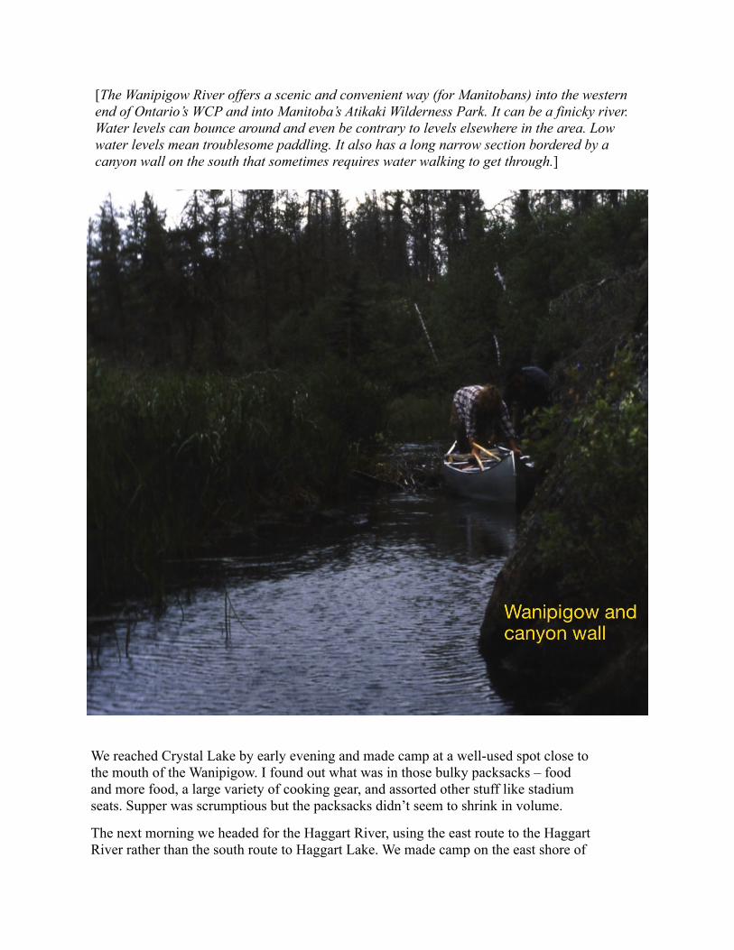
[The Wanipigow River offers a scenic and convenient way (for Manitobans) into the western end of Ontario’s WCP and into Manitoba’s Atikaki Wilderness Park. It can be a finicky river. Water levels can bounce around and even be contrary to levels elsewhere in the area. Low water levels mean troublesome paddling. It also has a long narrow section bordered by a canyon wall on the south that sometimes requires water walking to get through.]
We reached Crystal Lake by early evening and made camp at a well-used spot close to the mouth of the Wanipigow. I found out what was in those bulky packsacks – food and more food, a large variety of cooking gear, and assorted other stuff like stadium seats. Supper was scrumptious but the packsacks didn’t seem to shrink in volume.
The next morning we headed for the Haggart River, using the east route to the Haggart River rather than the south route to Haggart Lake. We made camp on the east shore of

the Haggart River, a short distance downstream from next day’s portage. Again supper was scrumptious but those packsacks still weren’t shrinking in size or reducing in number.
August 8th. We travelled a short cut from the Haggart River to Donald Lake. Two of my new partners had once went part of the way. The third (last) portage was the only unknown. The first portage was okay even though we were triple walking. The second portage was not. It went over steep and slippery rock outcrops (it was raining on and off) and through bushes whose purpose in life was to trip anyone passing by. We couldn’t find the third portage.
We decided that cutting a 400-metre trail would be unwise in the thick bush. A marshy creek connected the lake we were in to the small lake we wanted to reach, but only a canoe 30 centimetres long and one centimetre wide might be able to navigate it. So, with hordes of mosquitoes loving our presence, we pushed and dragged the loaded canoes over the soggy marsh. Two small ponds gave temporary relief from our poor impersonations of Clydesdale horses. After the pull and drag from the second pond, we reached terra firma and gladly bashed 50 metres through dense growth to reach the small lake.
From there, it was a painless and bug-free paddle to a small island at the south end of Donald Lake. The lake has number of cabins concentrated on the north and northeast shores, a legacy of former days when anyone with money and a plane could inhabit a piece of Canada’s wilderness.
New country lay ahead the next day. I had avoided the section of Royd Creek between Donald and Royd lakes in past trips to WCP because of stories that the creek was strewn with windfall. We were going up that creek to Royd Lake. Thankfully the possibility of sliding a canoe over logs pleased me more than the reality of triple walking our stuff on the rugged sections of the portages along the Gammon River way to Royd Lake.
We were in luck or maybe “boy scouts” had descended on the area. Except for one short log-strewn section and some portage landings that were designed for cliff-climbing beavers, the journey to Royd Lake was fabulous. Royd Creek is picturesque. I would recommend going that way if asked. We camped half way up the north arm of Royd Lake. After a wonderful evening meal of yeast dough pizza and rice desert made from scratch, I noticed some shrinkage in the packsacks.
More new country on August 10th. There is a chain of sausage lakes that runs northeast from Royd Lake to Murdock Lake on the Bloodvein system. I had traveled that path before. But there also is a chain that runs northwest to the Bloodvein via Simeon Creek. We were headed that way. The first hurdle was a little used 900-metre portage that we only double walked, an uplifting event for us all. As we traveled the narrow lakes, matters did not look promising. The short creek connections between them (these were portaged) were almost dry. Waiting ahead of us was a couple of kilometres of the creek that drained the chain. Maybe life smiles on those who are not devotees of the principle of travel light and walk over once. Miraculously the creek had sufficient water; where it came from is a mystery.
After several kilometres of narrow winding creek, where sometimes the canoe that was ahead appeared behind the canoe that was actually behind, we reached the jump-off point to the north and to the Bloodvein. Wanda Lake was not far downstream. Had we wanted to, we could have continued downstream, eventually ending up in Carroll Lake, just north of where the Haggart River enters.
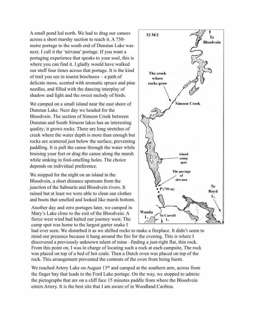
A small pond led north. We had to drag our canoes across a short marshy section to reach it. A 750-metre portage to the south end of Dunstan Lake was next. I call it the ‘nirvana’ portage. If you want a portaging experience that speaks to your soul, this is where you can find it. I gladly would have walked our stuff four times across that portage. It is the kind of trail you see in tourist brochures – a path of delicate moss, scented with aromatic spruce and pine needles, and filled with the dancing interplay of shadow and light and the sweet melody of birds.
We camped on a small island near the east shore of Dunstan Lake. Next day we headed for the Bloodvein. The section of Simeon Creek between Dunstan and South Simeon lakes has an interesting quality; it grows rocks. There are long stretches of creek where the water depth is more than enough but rocks are scattered just below the surface, preventing paddling. It is pull the canoe through the water while bruising your feet or drag the canoe along the marsh while sinking in foul-smelling holes. The choice depends on individual preference.
We stopped for the night on an island in the Bloodvein, a short distance upstream from the junction of the Sabourin and Bloodvein rivers. It rained but at least we were able to clean our clothes and boots that smelled and looked like marsh bottom. Another day and zero portages later, we camped in Mary’s Lake close to the exit of the Bloodvein. A fierce west wind had halted our journey west. The camp spot was home to the largest garter snake I had ever seen. We disturbed it as we shifted rocks to make a fireplace. It didn’t seem to mind our presence because it hung around the fire for the evening. This is where I discovered a previously unknown talent of mine –finding a just-right flat, thin rock. From this point on, I was in charge of locating such a rock at each campsite, The rock was placed on top of a bed of hot coals. Then a Dutch oven was placed on top of the rock. This arrangement prevented the contents of the oven from being burnt.
We reached Artery Lake on August 13th and camped at the southern arm, across from the finger bay that leads to the Ford Lake portage. On the way, we stopped to admire the pictographs that are on a cliff face 15 minutes paddle from where the Bloodvein enters Artery. It is the best site that I am aware of in Woodland Caribou.

[Notice the rock ledge at the foot of the cliff . One can imagine someone long ago standing there, canoe parked alongside, and creating pictographs on the cliff face. The second photo is a close up of part of the cliff face. A bison and possibly a shaman are prominent. ]

We stayed two nights in Artery. The record for the largest garter snake fell again. Our campsite was home to a monstrous snake that was over a 1 1/2 metres long and as thick as a very fat garlic sausage. [It reminded me of an African Rock python.] Fortunately for the snake, we still had enough food to feed a small army. Our plan was to rest and to eat and to eat so that we would be able to single walk the remaining portages (my dream). The Dutch oven baked turnovers and the reflector oven baked other things. I was in danger of regaining all the weight that I had lost triple walking over past portages. It was for good reason that we wanted to reduce our load. Five long and nasty portages were waiting for us: the rugged and sometimes steep 2200 m portage into Ford, the boggy 1300 m portage into Craven, and the dreaded 3-mothers Obukowin portage into Siderock (900 m, 1100 m, and 3000 m). The plan failed. The volume of food shrank admirably but the cooking and assorted other gear didn’t.
On August 15th we headed for Carroll Lake. We double walked the Ford and Craven portages. It took a whole day to reach the north end of Carroll. We camped on a splendid island just south of where Craven Creek enters Carroll. We were about 12 km south of our starting point on Artery, having walked over 10 km to get there. I grew fonder of my principle.
Next day was a pleasant paddle south through Carroll, a miniature version of Lake of the Woods with beaches, excellent campsites, and good fishing. After a short portage, we were in Obukowin, a shallow wild rice lake, and in Manitoba. We camped on a small island at the south end of the lake, close to the first of the 3-mothers.

I dreamed a good plan for portaging the 3-mothers. For each canoe, the canoe and packsacks, and any loose gear were to be arranged into three loads (load A, load B, load C). For each canoeing pair, person #1 carries load A all the way across the portage. Person #2 carries load B half way across and leaves it there. Person #2 then goes back to the start of the portage for the load C. Person #1 comes back to the halfway point and carries the deposited load B to the end of the portage. Person #2 carries load C all the way across the portage. If you do the math, each person walks two-thirds of the total distance normally walked on a double walk. For this, you must remember that a double walk actually involves walking three times the length of a portage – twice there and once back. The total portaging distance from Obukowin to Siderock is 5 kilometres. A double walk involves walking a total distance of 15 kilometres. The plan shrinks the distance to 10 kilometres. The elimination of 5 kilometres is not to be shunned when the terrain is boggy, lumpy, and like quick sand in too many places.
Well, plans in the head and plans in the bush are different matters, If one of the two persons can’t carry one of the loads (A, B, or C), then the plan won’t work. Needless to say, this was the case. The plan was nice in theory but impossible in practice. So there we were early on August 16th portaging the 3-mothers from Obukowin to Siderock by double walking the old-fashioned way. It took seven hours to reach Siderock.

[Notice that the third portage (from pond 2 to Siderock) has changed. When I first did the portage in 1970, the trailhead was close to where the Wanipigow River leaves Siderock Lake. The trail ran a short distance to the west of the creek until about where the present portage crosses the creek. The 1970 part of the trail west of the creek was fairly decent walking, with occasional wet areas. The Wallace Lake forest fire of 1987 wiped out the old portage trail. When the trail was re-cut, it was shifted to its present location.]
[Avoid the left fork in the trail as you get near pond 2 (when coming from Obukowin). It turns into the winter trail and ends in a nice stretch of bog slogging. If you prefer a quicksand experience, feel free to travel the left fork.]
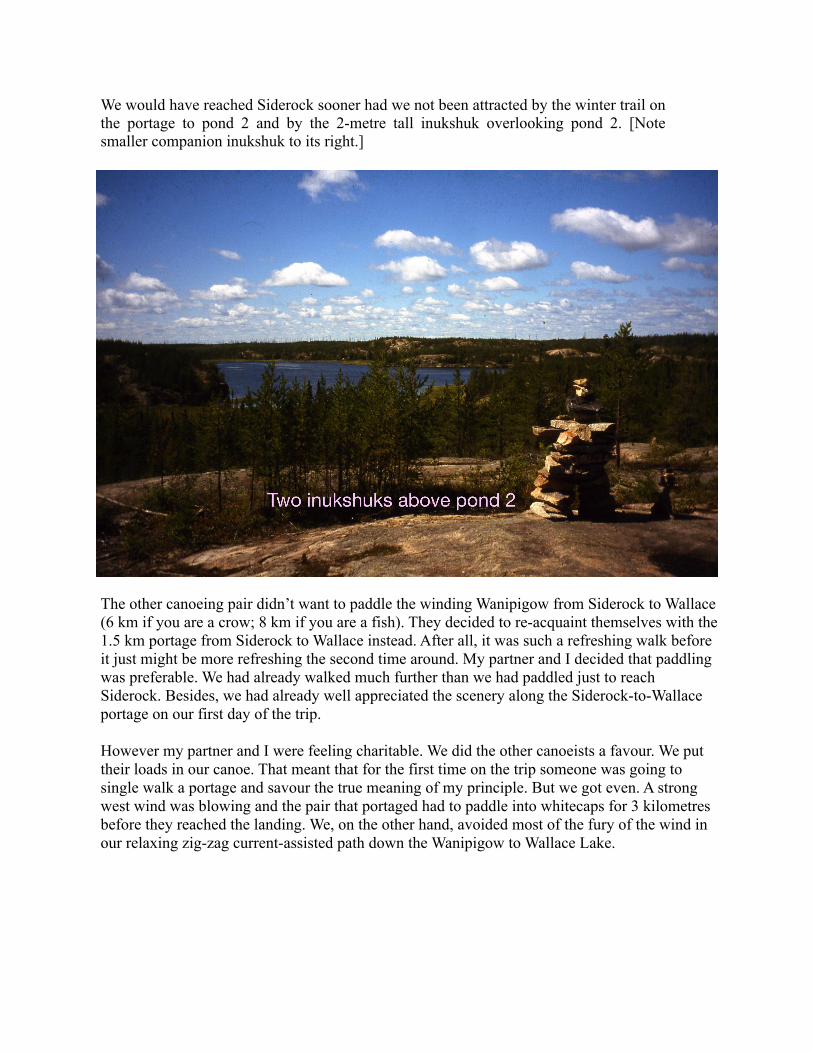
We would have reached Siderock sooner had we not been attracted by the winter trail on the portage to pond 2 and by the 2-metre tall inukshuk overlooking pond 2. [Note smaller companion inukshuk to its right.]
The other canoeing pair didn’t want to paddle the winding Wanipigow from Siderock to Wallace (6 km if you are a crow; 8 km if you are a fish). They decided to re-acquaint themselves with the 1.5 km portage from Siderock to Wallace instead. After all, it was such a refreshing walk before it just might be more refreshing the second time around. My partner and I decided that paddling was preferable. We had already walked much further than we had paddled just to reach Siderock. Besides, we had already well appreciated the scenery along the Siderock-to-Wallace portage on our first day of the trip.
However my partner and I were feeling charitable. We did the other canoeists a favour. We put their loads in our canoe. That meant that for the first time on the trip someone was going to single walk a portage and savour the true meaning of my principle. But we got even. A strong west wind was blowing and the pair that portaged had to paddle into whitecaps for 3 kilometres before they reached the landing. We, on the other hand, avoided most of the fury of the wind in our relaxing zig-zag current-assisted path down the Wanipigow to Wallace Lake.