the robert the bruce trail - bruce in dumfries · the robert the bruce trail and based on the fact...
TRANSCRIPT
Dumfries
CaerlaverockCastle
Kirkpatrick Fleming
Annan
The Robert the Bruce Trail
Ericstane
Clatteringshaws
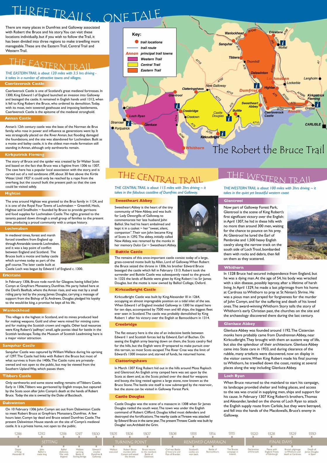
Key: trail locations trail route principal trail towns Western Trail Central Trail Eastern Trail
Annan
Wanlockhead
Sanquhar
Thornhill
LochmabenDalswinton
Tibbers
Hightae
B725
Creetown
Kirkcudbright
Buittle
SweetheartAbbey
Loch Ryan
Glenluce
Whithorn
Glentrool
A710
Creebridge
A75
A75A755
B797
B7040
(M)
A75 B7020
B702
0
B724
A75
A701
A76
A714
CastleDouglas
THREE TRAILS... ONE TALEThere are many places in Dumfries and Galloway associated with Robert the Bruce and his story. You can visit these locations individually, but if you wish to follow the Trail, it has been divided into three regions to make travelling more manageable. These are the Eastern Trail, Central Trail and Western Trail.
THE EASTERN TRAIL is about 120 miles with 3.5 hrs driving - it takes in a number of attractive towns and villages.
Caerlaverock Castle is one of Scotland’s great medieval fortresses. In 1300, King Edward I of England launched an invasion into Galloway and besieged the castle. It remained in English hands until 1312, when it fell to King Robert the Bruce, who ordered its demolition. Today, with its moat, twin towered gatehouse and imposing battlements, Caerlaverock Castle is the epitome of the medieval stronghold.
Annan’s 12th century castle was the base of the Norman de Brus family, who rose in power and influence as generations went by. It was strategically placed on the River Annan, but flooding damaged the foundations, and the site was abandoned for Lochmaben. Built as a motte and bailey castle, it is the oldest man-made formation still standing in Annan, although only earthworks remain.
The story of Bruce and the spider was created by Sir Walter Scott and based on the fact that Bruce was a fugitive from 1306 to 1307. The cave here has a popular local association with the story, and is carved out of a red sandstone cfiff, about 30 feet above the Kirtle Water. Until 1927 it could only be reached by a rope from the overhang, but the council built the present path so that the cave could be visited safely.
The area around Hightae was granted to the Brus family in 1124, and it is one of the Royal Four Towns of Lochmaben ~ Greenhill, Heck, Hightae and Smallholm ~ founded by Bruce to provide garrisons and food supplies for Lochmaben Castle. The rights granted to the tenants passed down through a small group of families to the present time, producing a proud community with a unique history.
In medieval times, forest and marsh forced travellers from England up through Annandale towards Lochmaben, and it was a key point of conflict between England and Scotland. The Bruces built a motte and bailey castle which survives today as part of the golf course. The later castle built at Castle Loch was begun by Edward I of England c. 1300.
In February 1306, Bruce rode north for Glasgow, having killed John Comyn at Greyfriars Monastery, Dumfries. His party halted here at the Devil’s Beeftub, where the Annan rises, and was met by a small riding party led by the young James Douglas, carrying a message of support from the Bishop of St. Andrews. Douglas pledged his loyalty to the would-be king, a promise he kept all his life.
This village is the highest in Scotland, and its mines produced lead for making weapons. Gold and silver were mined for minting coins and for making the Scottish crown and regalia. Other local resources were King Robert’s ‘palfreys’: small, agile ponies ideal for battle in the Scottish landscape. Today, the Museum of Scottish Leadmining here is a major visitor attraction.
Sanquhar Castle was captured by William Wallace during his uprising of 1297. The Castle had links with Robert the Bruce but most of what survives is from the 1400s. The Castle ruins are privately-owned and not open to the public, but may be viewed from the Southern Upland Way, which passes them.
Only earthworks and some stone walling remains of Tibbers Castle. Early in 1306, Tibbers was garrisoned by English troops, but captured by the Scots soon after John Comyn’s death at the hands of Robert Bruce. Today the site is owned by the Duke of Buccleuch.
On 10 February 1306 John Comyn set out from Dalswinton Castle to meet Robert Bruce at Greyfriars Monastery, Dumfries. A few hours later, Comyn lay dead and Bruce seized Dumfries Castle. The present Dalswinton House stands on the site of Comyn’s medieval castle. It is a private home, not open to the public.
THE EASTERN TRAIL
Caerlaverock Castle
Annan Castle
Kirkpatrick Fleming
Hightae
Lochmaben
Ericstane
Wanlockhead
Sanquhar Castle
Tibbers Castle
Dalswinton
THE CENTRAL TRAIL
Sweetheart Abbey
Buittle Castle
Kirkcudbright Castle
Creebridge
Clatteringshaws
Castle Douglas
THE WESTERN TRAIL
Glentrool
Whithorn
Glenluce Abbey
Loch Ryan
THE CENTRAL TRAIL is about 115 miles with 3hrs driving ~ it takes in the fabulous coastline of Dumfries and Galloway.
Sweetheart Abbey is the heart of the tiny community of New Abbey, and was built for Lady Devorgilla of Galloway, to commemorate her late husband John Balliol. She had his heart embalmed and kept it in a casket ~ her “sweet, silent, companion”. Their son John became King of Scots in 1292. The abbey, initially called New Abbey, was renamed by the monks in her memory Dulce Cor ~ Sweetheart Abbey.
The remains of this once-important castle consist today of a large, grass-covered motte built by Allan, Lord of Galloway. When Robert the Bruce seized the throne in 1306, his brother Edward Bruce beseiged the castle which fell in February 1313. Robert took the surrender and Buittle Castle was subsequently razed to the ground. In 1325 the lands of Buittle were given by King Robert I to Sir James Douglas. but the motte is now owned by Balliol College, Oxford.
Kirkcudbright Castle was built by King Alexander III in 1264, occupying an almost impregnable position on a tidal inlet of the sea. When Edward I of England invaded Galloway in 1300 he stayed here for ten days, accompanied by 7500 men and 60 ships, the biggest fleet ever seen in Scotland. The castle was probably demolished by King Robert 1 after his victory over the English at Bannockburn in 1314.
The flat estuary here is the site of an indecisive battle between Edward 1 and Scottish forces led by Edward, Earl of Buchan. On seeing the English army bearing down on them, the Scots cavalry fled for the hills, but the English were ill~prepared to make pursuit over this terrain, so most Scots escaped. The River Cree was the limit of Edward’s 1300 invasion and, starved of funds, he returned home.
In March 1307 King Robert hid out in the hills around Moss Raploch and Glentrool. An English army camped here was set upon by the Scots at dawn and, as the Scots picked over the dead for weapons and booty, the king rested against a large stone, now known as the Bruce Stone. The battle site itself is now submerged by the reservoir., but the stone can be visited in Galloway Forest Park.
Castle Douglas was the scene of a massacre in 1308 when Sir James Douglas raided the south west. The town was under the English command of Robert Clifford. Douglas killed most defenders and destroyed the fortifications. The nearby castle at Threave was attacked by Edward Bruce in the same year..The present Threave Castle was built by Douglas’ son, Archibald the Grim.
THE WESTERN TRAIL is about 100 miles with 3hrs driving ~ it takes in the quiet yet beautiful western coast
Now part of Galloway Forest Park, Glentrool is the scene of King Robert’s first significant victory over the English: in April 1307, he hid in these hills with no more than around 300 men, waiting for the chance to pounce on his prey. At Glentrool he lured the Earl of Pembroke and 1,500 heavy English cavalry along the narrow track on the south side of Loch Trool, bombarded them with rocks and debris, then fell on them as they scattered.
In 1328 Bruce had secured independence from England, but he was a dying man. At the age of 54, his body was wracked with a skin disease, possibly leprosy, after a lifetime of harsh living. In April 1329, he made a last pilgrimage from his home at Cardross to Whithorn to pray at St Ninian’s Shrine. He was a pious man and prayed for forgiveness for the murder of John Comyn, and for the suffering and death of his loved ones. The award-winning Whithorn Story tells the story of Whithorn’s early Christian past, the churches on the site and the archaeology discovered there during the last century.
Glenluce Abbey was founded around 1192. The Cistercian monks here probably came from Dundrennan Abbey, near Kirkcudbright. They brought with them an austere way of life, but also the splendour of their architecture. Glenluce Abbey came into State care in 1933, and during clearance of the rubble, many artefacts were discovered, now on display in the visitor centre. When King Robert made his final journey to Whithorn, he travelled down the coast, resting at several places along the way including Glenluce Abbey.
When Bruce returned to the mainland to start his campaign, its landscape provided shelter and hiding places, and access to the sea was crucial in supplying men, ships and support for his cause. In February 1307 King Robert’s brothers, Thomas and Alexander, landed on the shores of Loch Ryan to attack the English supply route from Carlisle, but they were betrayed, and fell into the hands of the Macdowalls, Bruce’s enemy in Galloway.

Journey back 700 years to the Wars of Independence and see Dumfries and Galloway through
the eyes of Scotland’s greatest King.
THE RObERT THE bRuCE TRAIL
Specific thanks for the support of Heritage Lottery Funding and Sulwath Connections Landscape Partnership project without whom this project would never have been realised.
Heritage Lottery Fund
Landfill Tax Credit
Forestry Commisssion Scotland
Clydesdale Bank
Galloway Associateion of Glasgow
the National Trust for Scotland
and donations from many other individual supporters.
Desigh by SS Crome Associates
Text illustrations & maps © SS Crome Associates & Dumfries & Galloway Council Printed by Solway Offset, Dumfries, 2009
Annandale Coat of Arms is reproduced by permission of the Lord Lyon King of Arms
Copyright of all information in this leaflet shall remain the property of Sulwath Connections Landscape Project and the Robert the Bruce Commemoration Trust
Historic Scotland
Common Good Fund
George Hunter Trust
Magnox North
Lochmaben Common Good
Greyfriars Church
St. Mary'sChurch
DumfriesMuseum
VIC
CastledykesPark
KEY: trail locations foot trail route
1
Devorgilla
’s
Bridge
Mill Rd
Pilgrim
’s
Way
DUMFRIESROBERT the BRUCE
Town TrailCycle track
Wallace’s
Loaning
Glencaple Rd
To Caerlaverock castle
St Michael’s St
King
h olm
Rd
Bankend Rd
Friars
Vennel
Englis
h St
2
4
5
6
7
Bank St
High St
St M
ary’s S
t
Whitesands
3 DumfRIES TOWN TRAIL
DumfRIES ToWN TRAIL takes approx 2.5 hrs, approx 3miles
1Turn right out of the Visitor Information Centre for 300m until you reach Friars Vennel.
Where next? Turn right here and walk 150m to the top of this medieval road until you find the
interpretive panel on the site of the Greyfriars Monastery. Established around 1292, it was here that Robert Bruce, Lord of Annandale murdered his rival John Comyn, Lord of Badenoch.
Where next? Walk to the top of Friar’s Vennel, turn left and find the wall plaque commemorating John Comyn’s death (left). Cross Church Crescent to the 19th century Greyfriars Church and find the Trail monolith. This church dates from 1868 but was named after the monastery which stood
across the road (right).
Robert the Bruce, King of Scots ~ visionary leader and invincible military general ~ is accepted as Scotland’s most successful monarch. His home territory was in Dumfries and Galloway, and the creation of the Trail provides the opportunity to tell the story of Robert Bruce ~ the man. Here he grew up, was influenced by the people, made friends and enemies, forged his skills and gained knowledge of his Celtic ancestry.
Places connected with Bruce are varied in nature. Most buildings from his time have long since gone, but the landscape remains beautiful and evocative. Most surviving buildings take the form of ruined abbeys and castles, but some are simply mounds in the ground where buildings once stood.
There are excellent museums and visitor centres close to many Trail sites and regional Visitor Information Centres have more information and most locations are supported by information panels, monoliths or plaques. Look out too for the Trail booklet which tells the full story, and gives directions to all the sites.
...The Robert the bruce Trail If you have watched ‘Braveheart’, you know it is based on the story of William Wallace’s fight for Scotland’s freedom from English oppression in medieval times. The film ends with Wallace’s execution in 1305, but the epilogue shows the subsequent victory by King Robert the Bruce at Bannockburn. The Robert the Bruce Trail tells the story of how a nobleman from south west Scotland gained the nation’s crown and recovered her freedom.
WELCOmE TO......
Today’s High Street would have bustled with travellers and tradesman in Medieval times. As the town grew, a market developed in what is known as Queensberry Square.
Where next? Walk down High Street and turn left on to English Street. St. Mary’s Church is on your left at the junction with Annan Road.The site of the present church was originally Hangman’s Hill where King Robert the Bruce’s brother-in-law, Sir Christopher Seton, was hanged in 1307
by the English. His widow, Christiana, later erected the Chapel of the Holy Rood in his memory. All that remains is the small stone pillar in front of the church (left).
2
3
4
Where next? Walk down English Street, right into High Street, then left into Bank Street. Bank Street was known as the ‘Stinking Vennel’, as in Medieval times a stream of waste material would drain down here into the river. At Whitesands cross Devorgilla’s Bridge turning left on to Mill Rd.5In around 1280, Lady Devorgilla of Galloway commissioned the original timber bridge in
Dumfries.The stone bridge you see today was built on its foundations in the 15th century and is the oldest multi-spanned bridge in Scotland (right). Devorgilla married John Balliol of Barnard Castle, and their son John became King of Scots in 1292, after a lengthy competition with the Bruce family.
Where next? Turn up Mill Brae and then left on to Church Street until you get to Dumfries Museum. The museum contains many artefacts from these times. Come face to face with King Robert and find out what life was like for the medieval townsfolk of the Royal Burgh of Dumfries. Examine a cast of Bruce’s skull (right); gaze at the decorated stonework from the high altar vicinity at Grey Friars, where Bruce killed John Comyn; find the key from the foundations of Castledykes, site of the castle where Robert Bruce raised the Royal Standard.
Where next? Turn right out of the museum on to Troqueer Road. Turn left on to Pilgrim’s Way and cross the suspension bridge. Turn right and walk the riverside cycle track until you reach Castledykes park.
After Comyn’s murder in 1306, Bruce gathered his men to race the mile or so here. He stormed Dumfries Castle where the unsuspecting English justices were holding their session. They quickly surrendered and Bruce displayed Scotland’s Royal Standard for the first time since John Balliol’s abdication ten years before. Take time to explore this lovely green space. There is the castle site itself,
picnic areas, a children’s playground and quarry gardens, where there
6
7
Where next? You can return to Visit Scotland on Whitesands, where the Trail began, or head south out of Dumfries on B725 to Caerlaverock Castle and begin the Eastern Trail.
© D
umfries &
Gallow
ay Council.
© Solway Heritage.
© Solw
ay Heritage.
Mural at Castledykes Park.