the sagebrush steppe treatment evaluation project ... sagebrush steppe treatment evaluation project...
TRANSCRIPT
United StatesDepartmentof Agriculture
Forest Service
Rocky MountainResearch Station
General Technical Report RMRS-GTR-237
April 2010
The Sagebrush Steppe Treatment
Evaluation Project (SageSTEP): A
Test of State-and-Transition Theory
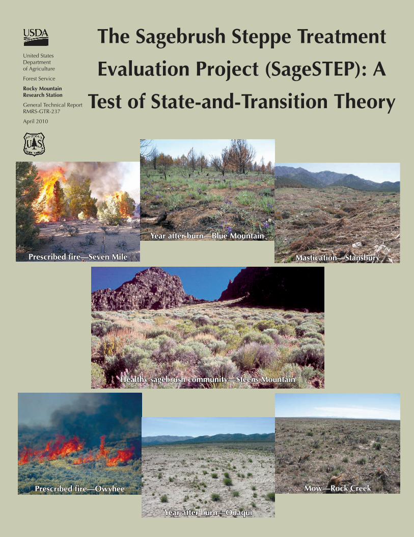
Prescribed fire—Seven Mile
Year after burn—Blue Mountain
Prescribed fire—Owyhee
Year after burn—Onaqui
Mastication—Stansbury
Mow—Rock Creek
Healthy sagebrush community—Steens Mountain
McIver, J.D.; Brunson, M.; Bunting, S.C., and others. 2010. The Sagebrush Steppe Treatment Evaluation Project (SageSTEP): a test of state-and-transition theory. Gen. Tech. Rep. RMRS-GTR-237. Fort Collins, CO: U.S. Department of Agriculture, Forest Service, Rocky Mountain Research Station. 16 p.
AbstractThe Sagebrush Steppe Treatment Evaluation Project (SageSTEP) is a comprehensive, integrated, long-term study that evaluates the ecological effects of fire and fire surrogate treatments designed to reduce fuel and to restore sagebrush (Artemisia spp.) communities of the Great Basin and surrounding areas. SageSTEP has several features that make it ideal for testing hypotheses from state-and-transition theory: it is long-term, experimental, multisite, and multivariate, and treatments are applied across condition gradients, allowing for potential identification of biotic thresholds. The project will determine the conditions under which sagebrush steppe ecological communities recover on their own following fuel treatment versus the communities crossing ecological thresholds, which requires expensive active restoration.
Keywords: fire surrogates, fire regimes, thresholds, resilience
You may order additional copies of this publication by sending your mailing information in label form through one of the following media. Please specify the publication title and series number.
Fort Collins Service Center
Telephone (970) 498-1392 FAX (970) 498-1122 E-mail [email protected] Web site http://www.fs.fed.us/rm/publications Mailing address Publications Distribution Rocky Mountain Research Station 240 West Prospect Road Fort Collins, CO 80526
Rocky Mountain Research Station240 W. Prospect Road
Fort Collins, Colorado 80526

Authors
James McIver is a Senior Research Associate Professor with the Eastern Oregon Agricultural Research Station at Oregon State University in Union, OR.
Mark Brunson is a Professor with the Department of Environment and Society at Utah State University in Logan, UT.
Steve Bunting is a Professor with the Department of Rangeland Ecology and Management at University of Idaho in Moscow, ID.
Jeanne Chambers is a Research Ecologist with the USDA Forest Service, Rocky Mountain Research Station, in Reno, NV.
Nora Devoe is Research Coordinator for Nevada with the USDI Bureau of Land Management in Reno, NV.
Paul Doescher is a Professor with the Department of Forest Resources at Oregon State University in Corvallis, OR.
James Grace is a Senior Research Ecologist with the USGS National Wetlands Research Center in Lafayette, LA.
Dale Johnson is a Professor with the Department of Environmental and Resource Sciences at University of Nevada in Reno, NV.
Steve Knick is a Wildlife Ecologist with the USGS Forest and Rangeland Ecosystems Science Center in Boise, ID.
Richard Miller is a Range Ecologist with the Department of Rangeland Ecology and Management at Oregon State University in Corvallis, OR.
Mike Pellant is a Range Management Specialist with the USDI Bureau of Land Management in Boise, ID.
Fred Pierson is a Research Hydrologist with the Northwest Watershed Research Center, Agricultural Research Services, in Boise, ID.
David Pyke is a Research Ecologist with the USGS Forest and Rangeland Ecosystems Science Center in Corvallis, OR.
Kim Rollins is an Associate Professor with the Department of Applied Economics and Statistics at University of Nevada in Reno, NV.
Bruce Roundy is a Professor with the Department of Plant and Wildlife Sciences at Brigham Young University in Provo, UT.
Eugene Schupp is a Professor with the Department of Wildland Resources at Utah State University in Logan, UT.
Robin Tausch is a Research Ecologist with the USDA Forest Service, Rocky Mountain Research Station, in Reno, NV.
David Turner is a Statistician with the USDA Forest Service, Rocky Mountain Research Station, in Logan, UT.

ContentsIntroduction ..................................................................................................... 1
State-and-Transition Models (STMs) .............................................................. 2STMs for Sagebrush Steppe Systems ............................................................ 2SageSTEP DESIGN and STMs ...................................................................... 6Treatment Plot ............................................................................................ 8Site Distribution .......................................................................................... 8Treatments .................................................................................................11Measured Variables .................................................................................. 12Analyses ................................................................................................... 13
Human Aspects .............................................................................................. 13Sociopolitical ........................................................................................... 13Economic ................................................................................................. 14Outreach .................................................................................................. 14
Summary ........................................................................................................ 14
Acknowledgments ......................................................................................... 15
References ...................................................................................................... 15
ii
USDA Forest Service RMRS-GTR-237. 2010. 1
IntroductionSagebrush (Artemisia spp.) habitats occupy 40 mil-
lion ha in the western United States and Canada (Knick and others 2003). Home to more than 350 vertebrate species (Wisdom and others 2002), sagebrush steppe lands represent an important recreation area, are the primary forage base for the western rangeland livestock industry, and provide water in a semi-arid region with one of the fastest growing human populations in North America. Sagebrush ecosystems are considered to be among the most endangered in western North America (Noss and others 1995; Bunting and others 2002), with perhaps a third of the pre-settlement area of sagebrush already converted to other land uses or highly degraded. Over the past 100 years, fire suppression, inappropri-ate livestock grazing, expansion of native conifers like juniper and pinyon pine (Juniperus occidentalis, J. os-teosperma; Pinus monophylla, P. edulis), and invasion of exotic weeds such as cheatgrass (Bromus tectorum) have contributed most to the decline of sagebrush com-munities in the Intermountain Region (Pellant 1994; Miller and Tausch 2001). In more mesic locations, conifer expansion and depletion of fine fuels due to in-appropriate livestock grazing has shifted fire regimes from relatively frequent and low to mixed severity (10 to 50 years mean fire return interval) to more infre-quent and high severity (>50 years mean fire interval) (Miller and Rose 1999; Miller and Tausch 2001; Miller and Heyerdahl 2008). In some places, this shift has re-sulted in nearly a six-fold increase in fuel loads (from 7 to 40 tons/ha) (Tausch and others 2004). In more xeric sagebrush ecosystems, exotic annual grasses have be-come more dominant at the expense of native perennial species, and these annuals have shifted mean fire return intervals from >50 years to <10 years in some places (Whisenant 1990). Under current climatic conditions, both pinyon and juniper woodlands and exotic annual
grasses have the potential to dominate an even greater area (Betancourt 1987; West and Van Pelt 1987; Miller and others 2000; Wisdom and others 2002), and glob-al warming is likely to exacerbate this trend (Tausch and Nowak 2000; Pyke and Knick 2003; Neilson and others 2005). Millions of taxpayer dollars are spent annually for fire suppression as a result of increased fire risk and sagebrush steppe degredation. The cumu-lative effects of degrading sagebrush habitats include increased threat to property and life, higher erosion and sedimentation, decreased water quality, declines in the forage base for domestic livestock, and decreased habi-tat for big game and threatened wildlife species (Knick and others 2003).
Federal land managers are attempting to arrest the conversion of sagebrush steppe communities into woodland and cheatgrass, restore a desirable herba-ceous understory, and reduce fuel loads by applying treatments such as prescribed fire, mowing, chain-ing, cutting, masticating, and/or herbicides. Although site-specific information exists on the effectiveness of some treatments, there is scant multidisciplinary sci-entific information available on treatment outcomes over the range of environmental and ecological con-ditions that occur across sagebrush habitats. Further, little is known about the actual costs of these treat-ments, particularly relative to fire suppression efforts, or how acceptable they are to society for reducing fu-els and restoring more desirable ecological conditions. Managers need multidisciplinary scientific informa-tion on the recovery potential of sagebrush ecosystems exhibiting different degrees of degradation and on the effectiveness of available treatments. Increasingly, managers rely on state-and-transition models (STMs) to determine recovery potentials and treatment alterna-tives for shrubland and grassland ecosystems (Briske and others 2005, 2006). In sagebrush ecosystems, the multisite, multidisciplinary scientific data necessary to
The Sagebrush Steppe Treatment
Evaluation Project (SageSTEP): A Test of
State-and-Transition Theory
2 USDA Forest Service RMRS-GTR-237. 2010.
Developing STMs for managed landscapes is impor-tant for both management and research. Coupled with information from ecological site descriptions, STMs enhance managers’ abilities to predict treatment effects and outcomes and to determine what risks they might take if they decide to do nothing (Briske and others 2006). From a research perspective, the construction of STMs encourages ecologists to think clearly about ecosystem structure and ecological processes and the influence of human and natural disturbances, species invasions, and management actions. STMs can be used both to identify relevant management hypotheses (Briske and others 2005) and to design experiments to test them. SageSTEP is a management experiment that is specifically designed to test hypotheses related to STMs and threshold crossings in sagebrush steppe ecosystems.
STMs for Sagebrush Steppe Systems
SageSTEP consists of two similarly designed exper-iments. The woodland experiment focuses on pinyon and/or juniper expansion into more mesic sagebrush steppe sites (12 to 14 inches precipitation), and the sage/cheat experiment focuses on cheatgrass invasion into more xeric sites (10 to 12 inches precipitation). We present a standard STM for each experiment, but we recognize that details of treatment response will vary among sites due to differences in vegetation composi-tion and abundance, soils, elevation, aspect, slope, and climate (Tables 1 and 2). In addition, inherent site dif-ferences will likely influence the timing and trajectory of vegetation recovery. Thus, it is important to evaluate treatment responses for at least 10 years after treatment to capture the pattern and timing of recovery and to develop accurate STMs for each site.
For the woodland experiment, the sagebrush steppe reference state can be represented by three phases (Figure 1). Phase Ia depicts an herbaceous plant com-munity consisting primarily of annual and perennial grasses and forbs that can persist on a site indefinitely with proper grazing and periodic low-intensity fire. If fire is suppressed and/or inappropriate grazing oc-curs, perennial herbaceous species decrease, sagebrush and other woody shrubs increase, and the site moves to Phase Ib. Pinyon and juniper seedling recruitment is facilitated by sagebrush and other woody shrubs (Chambers and others 1999; Chambers 2000), and after an increase in shrubs, trees are able to estab-lish and begin to increase their dominance on the site
evaluate the existing states and transitions and to de-velop appropriate prescriptions are lacking.
The Sagebrush Steppe Treatment Evaluation Project (SageSTEP) is a unique and unprecedented effort de-signed to collect these data and fully develop STMs for managing sagebrush steppe lands in the Interior West. SageSTEP tests specific predictions from STMs experimentally by evaluating the ecological effects of prescribed fire and its surrogates (mechanical and her-bicide treatments) at 21 sagebrush steppe sites in the Great Basin and surrounding areas. The project also evaluates social acceptability of fire and fire surrogate treatments, measures costs and benefits of treatment application, and explores ways to place information in the hands of land managers. In this report, we briefly introduce the concept and value of state-and-transition modeling for management and research, present STMs that represent the two ecological experiments within SageSTEP, and describe the research design in the context of those STMs. We then describe the human aspects of SageSTEP research, including its sociopo-litical, economic, and outreach components.
State-and-Transition Models (STMs)
With his observation that ecosystems could develop alternate stable states at different times on the same piece of ground, Holling (1973) set the stage for cur-rent thinking in rangeland ecology and its focus on threshold dynamics and STMs. Since their introduction about 20 years ago (Westoby and others 1989; Laycock 1991), STMs have become increasingly popular for vegetation evaluation and rangeland management in the western United States (Briske and others 2005; Bestelmeyer 2006). In contrast to traditional “range models” (Dyksterhuis 1949), STMs recognize and ac-commodate multiple successional pathways on single sites. Some pathways lead to alternate community phases within a single stable state, and the ecosystem can move among these phases without changing state. Other pathways may result in threshold crossings to al-ternative stable states. Once a threshold is crossed, the ecosystem typically does not return to its previous state without active management (Briske and others 2006). Rangeland professionals are knowledgeable enough to link soil and vegetation characteristics with STMs and, in fact, these are essential elements of Ecological Site Descriptions (Pyke and others 2002; Bestelmeyer and others 2004).

USDA Forest Service RMRS-GTR-237. 2010. 3
Tabl
e 1.
Lis
t of 1
4 S
ageS
TEP
site
s w
ithin
thre
e w
oodl
and
regi
ons,
plu
s cu
rren
t nat
ive
vege
tatio
n, s
oils
, ele
vatio
n ra
nge,
slo
pe, a
spec
t, an
d ye
ar tr
eatm
ents
wer
e ap
plie
d. (F
or e
ach
site
, pre
scrib
ed fi
re w
as a
pplie
d fir
st, f
ollo
wed
by
mec
hani
cal a
nd h
erbi
cide
trea
tmen
ts.)
Site
Cur
rent
nat
ive
vege
tatio
nSo
ilsEl
evat
ion
rang
eSl
ope/
aspe
ctYe
ar tr
eate
d
Wes
tern
Jun
iper
Reg
ion
B
lue
Mou
ntai
n S
iteM
ount
ain
Big
Sag
e,Id
aho
fesc
ue, S
andb
erg
blue
gras
s,
Blu
ebun
ch w
heat
gras
s
Loam
y, m
ixed
, mes
ic, L
ithic
to P
achi
c A
rgix
erol
ls15
00 -
1700
m5% N
2007
B
ridge
Cre
ekB
asin
Big
Sag
e,B
lueb
unch
whe
atgr
ass,
San
dber
g bl
uegr
ass,
Idah
o fe
scue
San
dy lo
am, f
rigid
Typ
ic H
aplo
xero
lls
to fr
igid
Tor
riorth
ents
800
- 900
m25
%N
W20
06
C
astle
head
(Hyd
rolo
gy o
nly)
Sam
e as
Blu
e M
ount
ain
site
Loam
y, m
ixed
frig
id, L
ithic
to P
achi
ci
Arg
ixer
olls
and
Hap
loxe
rolls
1600
- 20
00 m
5-8%
SE
, W20
07
D
evin
e R
idge
Mou
ntai
n B
ig S
age,
San
dber
g bl
uegr
ass,
Thu
rber
nee
dleg
rass
,S
quirr
elta
il
Coa
rse
grai
ned
sand
y lo
am, f
rigid
To
rrio
rthen
ts16
00 -
1700
m0-
8% W20
07
F
ive
Cre
eks
(B
irds
only
)M
ount
ain
Big
Sag
e,Id
aho
fesc
ue, S
andb
erg
blue
gras
sC
laye
y, s
mec
titic
, frig
id, L
ithic
A
rgix
erol
ls17
70 -
1920
m0
-27%
NE
, SE
, W20
08
W
alke
r But
teM
ount
ain
Big
Sag
eId
aho
fesc
ue, T
hurb
er n
eedl
egra
ss,
Squ
irrel
tail
San
dy lo
am, f
rigid
Typ
ic H
aplo
xero
lls14
00 -
1500
mFl
at20
06
Pin
yon-
Juni
per R
egio
n
M
arki
ng C
orra
lW
yom
ing
Big
Sag
e,Th
urbe
r nee
dleg
rass
Loam
y, m
ixed
, mes
ic, A
ridic
and
H
aplo
xero
llic
Dur
argi
ds23
00 -
2400
m6-
20%
NW
, NE
, SE
2006
S
even
Mile
Mt.
Mah
ogon
y/M
ount
ain
Big
Sag
e,B
lueb
unch
whe
atgr
ass,
mut
tong
rass
Loam
y-sk
elet
al, m
ixed
, frig
id L
ithic
and
Ty
pic
Arg
ixer
olls
2300
- 25
00 m
6-15
%N
W ,
E,
SE
2007
S
outh
Rub
yW
yom
ing
Big
Sag
e/B
itter
brus
h,B
lueb
unch
whe
atgr
ass,
San
dber
g bl
uegr
ass,
Thu
rber
nee
dleg
rass
Loam
y-sk
elet
al, c
arbo
natic
, mes
ic
Lith
ic X
erol
lic C
alci
orth
rids
2100
- 22
00 m
8-30
%A
ll as
pect
s20
08
S
pruc
e M
ount
ain
Wyo
min
g B
ig S
age,
Bla
ck S
age,
Blu
ebun
ch w
heat
gras
s, In
dian
rice
gras
sLo
amy-
skel
etal
, car
bona
tic, m
esic
Li
thic
Xer
ollic
Cal
cior
thrid
s22
00 -
2500
m3-
35%
NE
, E, S
2009
Uta
h Ju
nipe
r Reg
ion
G
reen
ville
Ben
chW
yom
ing
Big
Sag
e,N
eedl
e an
d Th
read
, Blu
ebun
ch w
heat
gras
sD
ecca
, ver
y gr
avel
ly to
cob
bly
sand
y lo
am17
50 -
1850
m2-
28%
N20
07
O
naqu
i W
yom
ing
Big
Sag
e,B
lueb
unch
whe
atgr
ass
Loam
y-sk
elet
al, c
arbo
natic
, mes
ic,
shal
low
Arid
ic P
etro
calc
ic
Pal
exer
olls
1700
- 21
00 m
2-30
%E
2006
S
cipi
oS
ame
as O
naqu
i site
Loam
y-sk
elet
al, m
ixed
, mes
ic, s
hallo
w
Cal
cic
Pet
roca
lcid
s17
00 -
1800
m2-
28%
W20
07
Sta
nsbu
ry M
ount
ains
Mou
ntai
n B
ig S
age/
Ant
elop
e B
itter
brus
h,
Blu
ebun
ch w
heat
gras
sLo
amy-
skel
etal
, mix
ed, m
esic
Arid
ic
Cal
cixe
rolls
1700
- 18
50 m
8-30
%W
2007

4 USDA Forest Service RMRS-GTR-237. 2010.
Tabl
e 2.
Lis
t of s
even
Sag
eSTE
P si
tes
with
in th
ree
sage
brus
h st
eppe
regi
ons,
plu
s cu
rren
t nat
ive
vege
tatio
n, s
oils
, ele
vatio
n ra
nge,
slo
pe, a
spec
t, an
d ye
ar tr
eatm
ents
wer
e ap
plie
d.
(For
eac
h si
te, p
resc
ribed
fire
was
app
lied
first
, fol
low
ed b
y m
echa
nica
l and
her
bici
de tr
eatm
ents
.)
Site
Cur
rent
nat
ive
vege
tatio
nSo
ilsEl
evat
ion
rang
eSl
ope/
aspe
ctYe
ar tr
eate
d
Hum
bold
t/Bon
nevi
lle R
egio
n
O
naqu
iW
yom
ing
Big
Sag
e/A
ntel
ope
bitte
rbru
sh,
Blu
ebun
ch w
heat
gras
s, S
lend
er w
heat
gras
sFi
ne-lo
amy,
mix
ed, m
esic
Xer
ollic
C
alci
orth
ids
1750
- 18
50 m
3-4% E
2006
O
wyh
ee
Wyo
min
g B
ig S
age,
Blu
ebun
ch w
heat
gras
s, S
quirr
elta
il, T
hurb
er
need
legr
ass,
San
dber
g bl
uegr
ass,
W
ildry
e
Fine
-silt
y to
fine
-loam
y, m
ixed
, mes
ic,
shal
low
, Xer
ollic
Dur
argi
ds,
Dur
ixer
ollic
Cam
borth
ids,
and
D
urix
erol
lic H
apla
rgid
s
1700
- 17
50 m
0-10
%A
ll as
pect
s20
08
R
ober
tsW
yom
ing
Big
Sag
e,B
lueb
unch
whe
atgr
ass
Fine
- to
coar
se-lo
amy,
mix
ed,
supe
ract
ive,
frig
id X
eric
H
aplo
calc
ids
1550
- 16
00 m
0-10
%A
ll as
pect
s20
07
Hig
h D
eser
t Reg
ion
H
art M
ount
ain
Gra
y B
utte
Wyo
min
g B
ig S
age,
Squ
irrel
tail,
Thu
rber
nee
dleg
rass
Bra
ce: F
ine-
loam
y, m
ixed
, frig
id X
eric
A
rgid
urid
s
Raz
: Loa
my,
mix
ed, s
uper
activ
e,
frigi
d, s
hallo
w X
eric
Hap
lodu
rids
1450
- 16
00 m
0-10
%A
ll as
pect
s20
08
H
art M
ount
ain
Roc
k C
reek
Sam
e as
Gra
y B
utte
site
Sam
e as
Har
t Mou
ntai
n G
ray
But
te
site
1450
- 16
00 m
0-10
%A
ll as
pect
s20
07
Low
Des
ert R
egio
n
M
oses
Cou
lee
Wyo
min
g B
ig S
age,
Blu
ebun
ch w
heat
gras
s, S
quirr
elta
il,
San
dber
g bl
uegr
ass
Skah
a: L
oam
y-sk
elet
al, m
ixed
, su
pera
ctiv
e, m
esic
Arid
ic
Hap
loxe
rolls
St
rat:
Loam
y-sk
elet
al, m
ixed
, su
pera
ctiv
e, m
esic
Vitr
itorr
andi
c H
aplo
xero
lls
Tubs
prin
g: C
oars
e-lo
amy
over
sa
ndy
or s
andy
-ske
leta
l, m
ixed
, su
pera
ctiv
e, m
esic
Cal
cidi
c H
aplo
xero
lls
515
– 53
0 m
0-10
%S
2008
/200
9(m
echa
nica
l, he
rbic
ide—
2008
; fir
e—20
09)
S
addl
e M
ount
ain
Wyo
min
g B
ig S
age,
Blu
ebun
ch w
heat
gras
s, In
dian
rice
gras
s,
Bot
tlebr
ush
squi
rrel
tail
Coa
rse-
silty
, mix
ed, s
uper
activ
e,
mes
ic X
eric
Hap
loca
mbi
ds26
2 –
286
m1-
5% S20
08
USDA Forest Service RMRS-GTR-237. 2010. 5
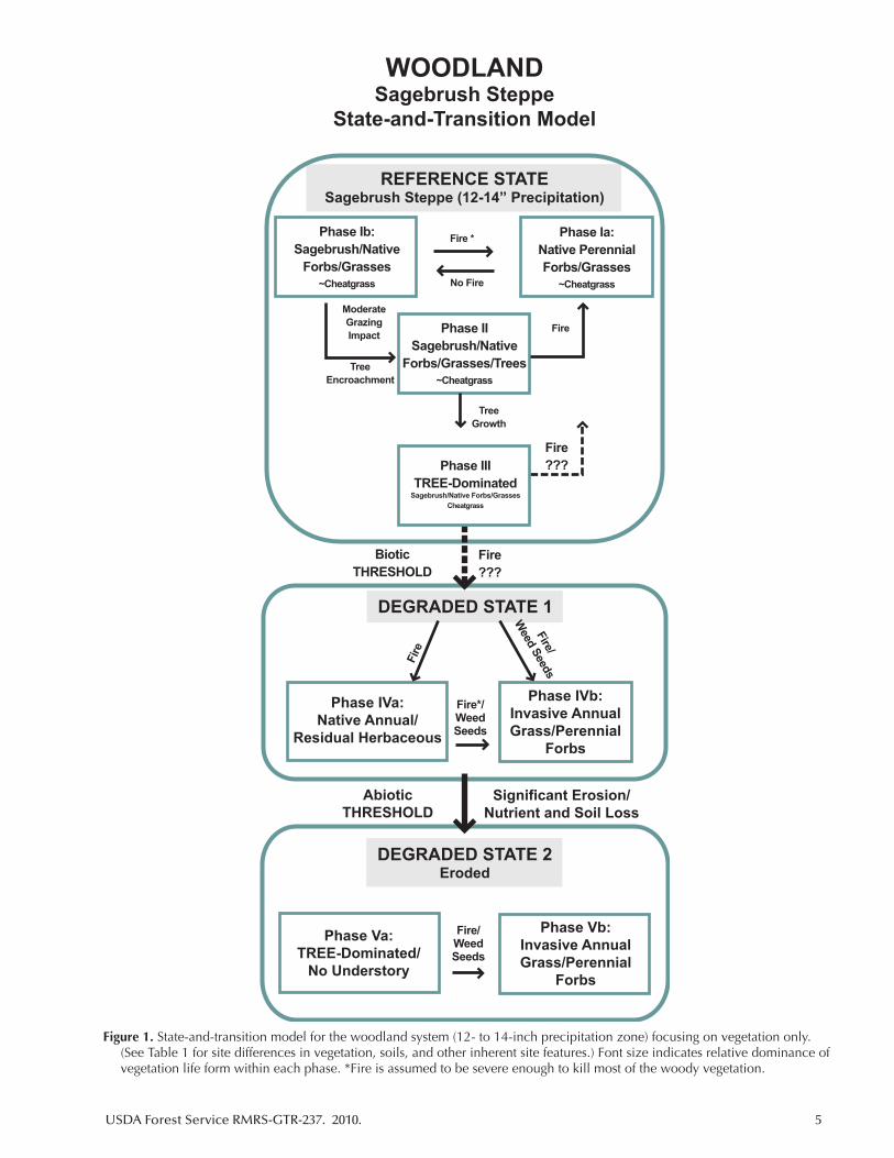
Figure 1. State-and-transition model for the woodland system (12- to 14-inch precipitation zone) focusing on vegetation only. (See Table 1 for site differences in vegetation, soils, and other inherent site features.) Font size indicates relative dominance of vegetation life form within each phase. *Fire is assumed to be severe enough to kill most of the woody vegetation.
WOODLANDSagebrush Steppe
State-and-Transition Model
Phase Ib:Sagebrush/Native
Forbs/Grasses~Cheatgrass
Phase Ia:Native PerennialForbs/Grasses
~Cheatgrass
Phase IISagebrush/Native
Forbs/Grasses/Trees~Cheatgrass
Phase IIITREE-Dominated
Sagebrush/Native Forbs/GrassesCheatgrass
Fire *
No Fire
Fire
Fire???
TreeGrowth
TreeEncroachment
ModerateGrazingImpact
BioticTHRESHOLD
Fire???
REFERENCE STATESagebrush Steppe (12-14” Precipitation)
DEGRADED STATE 1
Phase IVa:Native Annual/
Residual Herbaceous
Phase IVb:Invasive AnnualGrass/Perennial
Forbs
Fire*/WeedSeeds
Fire/
Weed Seeds
Fire
AbioticTHRESHOLD
Significant Erosion/Nutrient and Soil Loss
DEGRADED STATE 2Eroded
Phase Vb:Invasive AnnualGrass/Perennial
Forbs
Phase Va:TREE-Dominated/
No Understory
Fire/WeedSeeds
6 USDA Forest Service RMRS-GTR-237. 2010.
(Phase II). Low to moderate grazing and fire of ade-quate severity to kill woody vegetation can result in a shift from Phase II back to Phase I. The successional process then repeats itself. The predominate feedback mechanism that maintains the plant community within the reference state is negative as fire returns at rela-tively frequent intervals due to steadily increasing fuel loads that accumulate with plant succession. As long as the understory herbaceous vegetation layer remains relatively abundant and well-distributed, fuel continu-ity is generally sufficient to support surface fires over a fairly wide range of weather conditions. Heavy grazing or lack of fire can result in tree dominance and deple-tion of both shrubs and herbaceous understory species (Phase III). Fine fuels may be insufficient for surface fire and the system may not return to more seral phases within the reference state. As a result of the changes in the plant community at this point, the system is at risk of crossing a biotic threshold to Degraded State 1. The plant community is now either dominated by inva-sive annuals such as cheatgrass or is characterized by the expansion of native annual cover. The threshold is “triggered” by tree competition or overgrazing, both of which are processes that decrease the ecological role of the herbaceous understory. This biotic threshold is characterized by the dominance of a positive feedback mechanism by which continued tree growth makes the system more impervious to surface fire. Even if the trees are removed, the residual plant community may be so depleted that it will not return to the ref-erence state without re-seeding. Phase III will persist indefinitely with trees gradually acquiring more of the available resources until canopy structure, fuel loads, and weather conditions are conducive to a crown fire. A Phase IV plant community typically then results, dominated either by native annual grasses and forbs (Phase IVa) or by invasive plants if seeds are available (Phase IVb). Degraded State 2 may occur on steeper slopes and under certain soil conditions. To reach this state, an abiotic threshold is crossed in which erosion causes soil and nutrient loss (Phase V). The worst-case scenario is Phase Vb, an eroded state where crown fire eventually occurs and leaves a condition in which only native or invasive species that can tolerate the altered conditions can establish and persist.
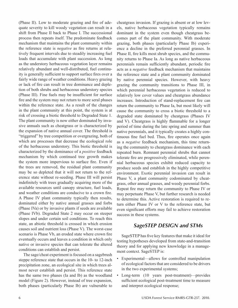
The sage/cheat experiment is focused on a sagebrush steppe reference state that occurs in the 10- to 12-inch precipitation zone, an ecological site in which trees al-most never establish and persist. This reference state has the same two phases (Ia and Ib) as the woodland model (Figure 2). However, instead of tree expansion, both phases (particularly Phase Ib) are vulnerable to
cheatgrass invasion. If grazing is absent or at low lev-els, native herbaceous vegetation typically remains dominant in the system even though cheatgrass be-comes part of the plant community. With moderate grazing, both phases (particularly Phase Ib) experi-ence a decline in the preferred perennial grasses. In Phase II, fire kills most shrub species, and the commu-nity returns to Phase Ia. As long as native herbaceous perennials remain sufficiently abundant, periodic fire acts as a negative feedback mechanism that maintains the reference state and a plant community dominated by native perennial species. However, with heavy grazing the community transitions to Phase III, in which perennial herbaceous vegetation is reduced to relatively low cover values and cheatgrass abundance increases. Introduction of stand-replacement fire can return the community to Phase Ia, but most likely will cause the community to cross a biotic threshold to a degraded state dominated by cheatgrass (Phases IV and V). Cheatgrass is highly flammable for a longer period of time during the late spring and summer than native perennials, and it typically creates a highly con-tinuous fine fuel bed. Thus, fire operates once again as a negative feedback mechanism, this time return-ing the community to cheatgrass dominance with each repeated burn. Remnant perennial shrubs that cannot tolerate fire are progressively eliminated, while peren-nial herbaceous species exhibit reduced capacity to produce seeds and establish in the highly competitive environment. Exotic perennial invasion can result in Phase V, a plant community codominated by cheat-grass, other annual grasses, and weedy perennial forbs. Repeat fire may return the community to Phase IV or may perpetuate Phase V, but further research is needed to determine this. Active restoration is required to re-turn either Phase IV or V to the reference state, but even significant efforts may fail to achieve restoration success in these systems.
SageSTEP DESIGN and STMs
SageSTEP has five key features that make it ideal for testing hypotheses developed from state-and-transition theory and for applying new knowledge in a manage-ment context. SageSTEP is:
• Experimental—allows for controlled manipulation of ecological factors that are considered to be drivers in the two experimental systems;
• Long-term (10 years post-treatment)—provides sufficient ecological post-treatment time to measure and interpret ecological response;
USDA Forest Service RMRS-GTR-237. 2010. 7
Figure 2. State-and-transition model for the sage/cheat system (10- to 12-inch precipitation zone) focusing on vegetation only. (See Table 2 for site differences in vegetation, soils, and other inherent site features.) Font size indicates relative dominance of vegetation life form within each phase. *Fire is assumed to be severe enough to kill most of the woody vegetation.
SAGE/CHEATSagebrush Steppe
State-and-Transition Model
Phase Ib:Sagebrush/Native
Forbs/GrassesCheatgrass
Phase Ia:Native PerennialForbs/Grasses
Cheatgrass
Phase IISagebrush/Native
Forbs/Grasses
Cheatgrass
Phase IIISagebrush/Native
Forbs/Grasses
Cheatgrass
Fire *
No Fire
Fire
Fire???
HeavyGrazingImpact
ModerateGrazingImpact
BioticTHRESHOLD
Fire???
REFERENCE STATESagebrush Steppe (10-12” Precipitation)
DEGRADED STATE
Phase IV:Cheatgrass-Dominated
Fire
Phase V:Cheatgrass+
Invasive Perennials
InvasivePerennial
Seeds
FrequentFire*
8 USDA Forest Service RMRS-GTR-237. 2010.
• Multisite—evaluates responses across the range of environmental conditions that characterize the region;
• Multivariate—measures both dependent and inde-pendent variables to not only characterize response but also to identify mechanisms behind that response; and
• STM-based—applies treatments across the range of ecological conditions that characterize the states and phases within the woodland and sage/cheat STMs.
These five features are incorporated into both the woodland and sage/cheat experiments. Each experi-ment is comprised of several replicate sites (N = 12 for woodland; N = 7 for sage/cheat), and each site rep-resents a block where alternative fire or fire surrogate treatments are applied at the plot level. Each treatment plot includes between 15 and 24 measurement sub-plots established to span a wide gradient of ecological conditions. We describe this study design in detail, starting with the treatment plot, which is designed to study treatment response across the condition gradient.
Treatment Plot
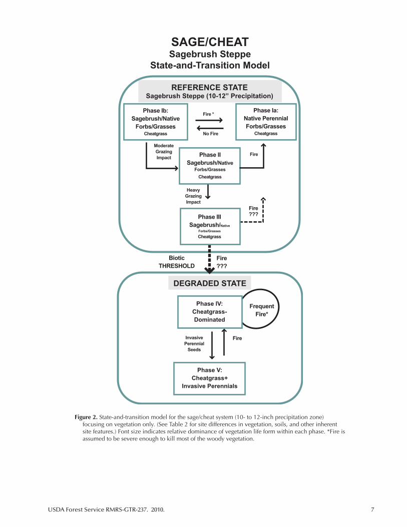
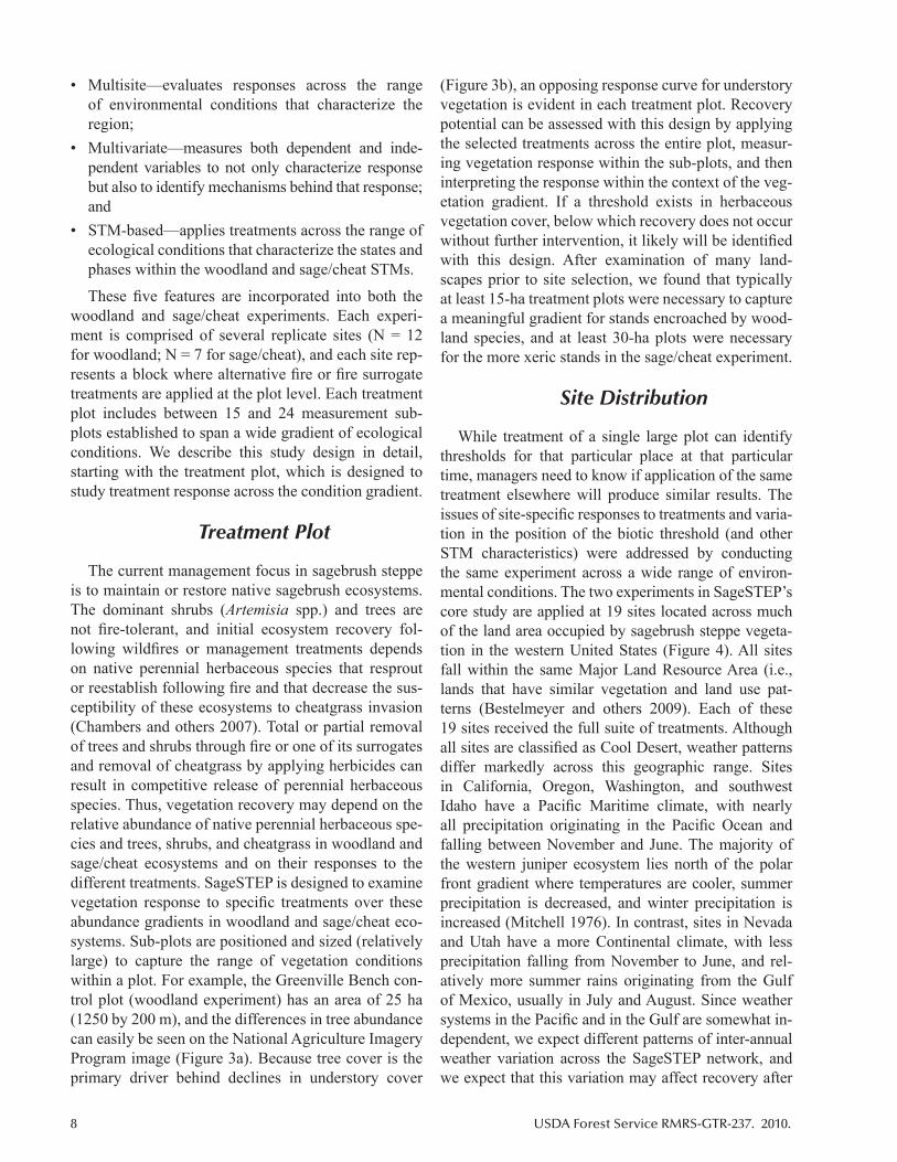
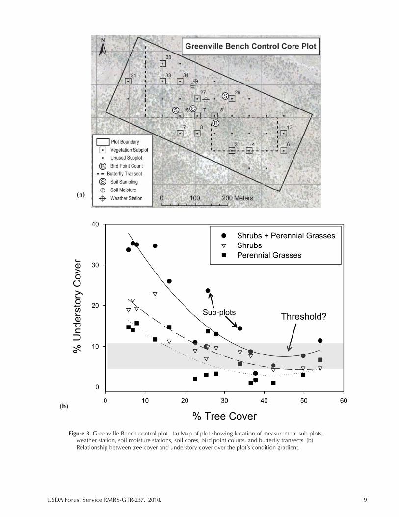
The current management focus in sagebrush steppe is to maintain or restore native sagebrush ecosystems. The dominant shrubs (Artemisia spp.) and trees are not fire-tolerant, and initial ecosystem recovery fol-lowing wildfires or management treatments depends on native perennial herbaceous species that resprout or reestablish following fire and that decrease the sus-ceptibility of these ecosystems to cheatgrass invasion (Chambers and others 2007). Total or partial removal of trees and shrubs through fire or one of its surrogates and removal of cheatgrass by applying herbicides can result in competitive release of perennial herbaceous species. Thus, vegetation recovery may depend on the relative abundance of native perennial herbaceous spe-cies and trees, shrubs, and cheatgrass in woodland and sage/cheat ecosystems and on their responses to the different treatments. SageSTEP is designed to examine vegetation response to specific treatments over these abundance gradients in woodland and sage/cheat eco-systems. Sub-plots are positioned and sized (relatively large) to capture the range of vegetation conditions within a plot. For example, the Greenville Bench con-trol plot (woodland experiment) has an area of 25 ha (1250 by 200 m), and the differences in tree abundance can easily be seen on the National Agriculture Imagery Program image (Figure 3a). Because tree cover is the primary driver behind declines in understory cover
(Figure 3b), an opposing response curve for understory vegetation is evident in each treatment plot. Recovery potential can be assessed with this design by applying the selected treatments across the entire plot, measur-ing vegetation response within the sub-plots, and then interpreting the response within the context of the veg-etation gradient. If a threshold exists in herbaceous vegetation cover, below which recovery does not occur without further intervention, it likely will be identified with this design. After examination of many land-scapes prior to site selection, we found that typically at least 15-ha treatment plots were necessary to capture a meaningful gradient for stands encroached by wood-land species, and at least 30-ha plots were necessary for the more xeric stands in the sage/cheat experiment.
Site Distribution
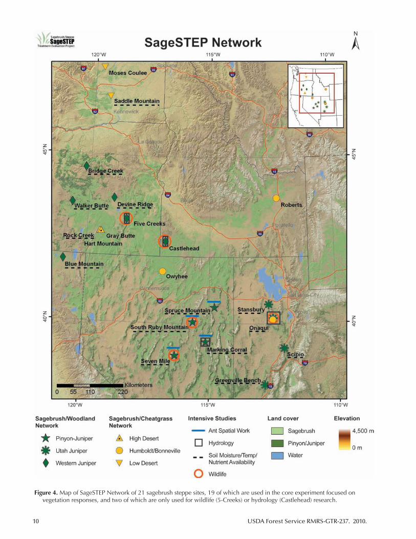
While treatment of a single large plot can identify thresholds for that particular place at that particular time, managers need to know if application of the same treatment elsewhere will produce similar results. The issues of site-specific responses to treatments and varia-tion in the position of the biotic threshold (and other STM characteristics) were addressed by conducting the same experiment across a wide range of environ-mental conditions. The two experiments in SageSTEP’s core study are applied at 19 sites located across much of the land area occupied by sagebrush steppe vegeta-tion in the western United States (Figure 4). All sites fall within the same Major Land Resource Area (i.e., lands that have similar vegetation and land use pat-terns (Bestelmeyer and others 2009). Each of these 19 sites received the full suite of treatments. Although all sites are classified as Cool Desert, weather patterns differ markedly across this geographic range. Sites in California, Oregon, Washington, and southwest Idaho have a Pacific Maritime climate, with nearly all precipitation originating in the Pacific Ocean and falling between November and June. The majority of the western juniper ecosystem lies north of the polar front gradient where temperatures are cooler, summer precipitation is decreased, and winter precipitation is increased (Mitchell 1976). In contrast, sites in Nevada and Utah have a more Continental climate, with less precipitation falling from November to June, and rel-atively more summer rains originating from the Gulf of Mexico, usually in July and August. Since weather systems in the Pacific and in the Gulf are somewhat in-dependent, we expect different patterns of inter-annual weather variation across the SageSTEP network, and we expect that this variation may affect recovery after
USDA Forest Service RMRS-GTR-237. 2010. 9
Figure 3. Greenville Bench control plot. (a) Map of plot showing location of measurement sub-plots, weather station, soil moisture stations, soil cores, bird point counts, and butterfly transects. (b) Relationship between tree cover and understory cover over the plot’s condition gradient.
40
Shrubs + Perennial GrassesShrubsPerennial Grasses
20
30
Threshold?Sub-plots
% U
nder
stor
y C
over
10
% Tree Cover
0
0 10 20 30 40 50 60
(a)
(b)
10 USDA Forest Service RMRS-GTR-237. 2010.
Figure 4. Map of SageSTEP Network of 21 sagebrush steppe sites, 19 of which are used in the core experiment focused on vegetation responses, and two of which are only used for wildlife (5-Creeks) or hydrology (Castlehead) research.
USDA Forest Service RMRS-GTR-237. 2010. 11
treatment. If among-site recovery rates and/or patterns mirror vulnerability, then more xeric sites, or sites with higher inter-annual variation in weather, may be slower to recover relative to more mesic, or less variable, sites (Chambers and others 2007). We collect weather data at each site throughout the study period from weather sta-tions located in the control plot of each site (Figure 3a). These data are used as a covariate in the analyses to help explain vegetation response.
The 12 woodland sites can be organized into three regions, each reflecting the dominant tree spe-cies (Figure 4). With four sites located in Oregon and Northern California, the Western Juniper Region is roughly defined by a triangle 300 km on the side. The four sites within the Pinyon-Juniper Region are more tightly clustered in east-central Nevada. The Utah Juniper Region consists of four sites in western Utah, spanning a north to south geographic range of roughly 400 km. Altogether, the 12 woodland sites span a geo-graphic range of more than 800 km, from Bridge Creek in the northwest to Greenville Bench in the southeast, and represent conditions that vary considerably in eleva-tion, topography, soils, current vegetation, and climate (Table 1).
The cheatgrass experiment consists of seven sites, all within the sagebrush biome but separated by more than 1000 km from south-central Washington to west-central Utah (Figure 4). Four of these sites are located in the western part of the sagebrush range, two are in cen-tral Oregon (High Desert Region), and two are in the Columbia Basin of southern Washington (Low Desert Region). Three of the sites are located in the eastern portion of the range (Bonneville Region), with one in Utah, one in eastern Idaho, and one in northern Nevada. Although all seven sites are typical sagebrush steppe systems, they also encompass a range of soil types, plant communities, and weather patterns (Table 2).
While most sampling occurs within the plots and sub-plots, analyses are conducted not only at the plot level, but at the site, region, and network levels. The hierarchical organization of the study reflects the sam-pling orientation and sets the stage for different kinds of analyses. If native perennial herbaceous vegetation has an effect on recovery and thresholds as originally predicted, we will be able to determine its relative im-portance at both site and regional levels for the woodland and sage/cheat experiments. Because other factors like soil characteristics, weather patterns, and abundance of other plant life forms, especially cheatgrass, likely have additional effects, we also will be able to determine their relative contribution to recovery and thresholds.
Treatments
For both the woodland and sage/cheat core experi-ments, a full set of treatments were applied at each site to achieve a statistical block. These treatments are commonly used to decrease woody fuels and to main-tain or restore sagebrush ecosystems. The woodland experiment features three plot-level treatments: pre-scribed fire, cut and fell, and mastication. Treatment plots range in size from 10 to 30 ha, each of which has 15 measured sub-plots positioned to cover a broad condition gradient. Prescribed fire was applied first, between August and November of 2006, 2007, or 2008 (Table 1). The goal was to accomplish 100 percent tree mortality within each treatment plot. However, due to considerable variation in weather conditions, prescribed fires only burned between 20 and 95 per-cent area. For those plots in which percent area burned was low, we blackened every sub-plot where the low measurements were taken. Cut and fell and mastica-tion treatments were implemented within six months of fire treatments. All trees >2 m tall were cut down and left on the ground across the contour. An additional treatment was applied at the four Utah juniper sites—all trees >2 m tall were masticated with the Bullhog®, a machine with a rotary mower capable of shredding even the largest juniper trees. An untreated plot serves as a control to complete the three-treatment ensemble for each woodland site (four treatments for the Utah juniper region).
The sage/cheat experiment includes four plot-level treatments per site: prescribed fire, application of the herbicide tebuthiuron, rotary mowing, and application of the herbicide imazapic nested within each of the other treatments. Treatment plots range in size from 20 to 80 ha, each of which has 18 measured sub-plots po-sitioned to cover a broad condition gradient. Prescribed fire was applied first, from May to October of 2006, 2007, or 2008 (Table 2). The goal was to accomplish 100 percent fire coverage. In some cases, weather con-ditions did not cooperate, with the result that some plots were not completely burned. In these cases, fire crews blackened every sub-plot where measurements occurred. Once fire was implemented for each site, both herbicide and mowing treatments were applied to two other plots within the following eight months. Both treatments were designed to remove about 50 percent of sagebrush cover to reduce woody fuels and release the understory herbaceous species. The herbicide tebuthiuron (N -[5-1,1-dimethylethyl-1,3,4-thiadiazol-2-yl]- N,N’ –dimethylurea) was applied over the entire
12 USDA Forest Service RMRS-GTR-237. 2010.
plot at a rate dictated by prior testing to remove 50 percent of the overstory. Rotary mowers were set at a pre-determined height to remove 50 percent of sage-brush biomass over the entire plot. An untreated plot served as the control to complete the four-treatment ensemble of plot-level applications for each site. The pre-emergent herbicide imazapic (3-Pyridinecarboxylic acid, 2-(4,5-dihydo-4-methyl-4-(1-methylethyl)-5–oxo-1H-imidazol-2-yl)-5-methyl-monoammonium salt) was applied to half of the sub-plots within each of the three or four plots per site (including control) simultaneous to each of the other treatments. At low rates, imazapic selectively acts on annual plants.
Measured Variables
SageSTEP measures well over 100 distinct vari-ables that can be roughly classified as response (dependent) or explanatory (independent) variables. To evaluate ecological response, a comprehensive set of variables are measured within each of the 1050 sub-plots, capturing both structural and compositional elements of the system. These variables are measured pre-treatment and for at least 10 years post-treatment within each of the 0.1-ha sub-plots (30 by 33 m) in the two experiments. Cover and density of trees, shrubs, forbs, and grasses are measured, and analyses focus on how these vegetation components respond to treat-ment in relation to the vegetation gradients. Biological crust cover, bare ground cover, harvester ant mounds, and ant community structures are also measured with-in each sub-plot because of their potential relevance to vegetation recovery. A number of critical explanatory variables are measured to aid in interpretation of vege-tation response, including: (1) inherent features of the sub-plot, such as slope, aspect, topographic position, and elevation; (2) all components of the fuel bed with-in sub-plots, such as standing and down woody fuel, litter, duff, and live fuels; (3) inherent soil properties, such as depth, texture, and moisture; (4) soil chemis-try, with a focus on nitrogen availability and carbon; and (5) air temperature and precipitation, at weather stations placed in the center of each control plot. Each time a sub-plot is measured, two photo points are taken at the 0- and 30-m marks of the central (15 m) transect using a digital camera. These geo-referenced photo points are used to document vegetation recov-ery over the long term and to aid in interpretation of vegetation response. This suite of variables will aid in quantifying STM differences among sites because recovery processes likely will largely depend on how different variables interact in the context of climate
zones and weather patterns. Including variables that managers or scientists believe are potentially relevant maximizes the likelihood of capturing indicator pat-terns that are connected to critical processes (Pyke and others 2002). Finally, it is imperative that variables be measured for at least 10 years post-treatment because of uncertainty about the length of time required for vegetation recovery and because of the community’s potential to return to the reference state. In fact, time frames must be fully understood in order to complete an STM (Bestelmeyer and others 2004).
Faunal response was also measured at the treatment plot level, particularly passerine bird and butterfly response. Passerine bird point counts are conduct-ed annually in each treatment plot for the woodland experiment only, while 1000-m butterfly transect sur-veys are conducted within treatment plots for both the woodland and sage/cheat experiments. Thus, the ef-fects of fire and fire surrogates on both passerine bird and butterfly abundances can be assessed with this de-sign. Because average home range size for passerine birds is too large to study populations within typical SageSTEP treatment plots, bird research also includes intensive demographic work on seven species of sage-obligate passerine birds within 10 400-ha plots—one control and one prescribed burn plot for each of five woodland sites (Figure 4). Because sage-obligate passerines are known to have similar habitat prefer-ences to sage grouse (a species of concern), research on these birds should provide insight into treatment effects on grouse populations. More generally, an important rationale for measuring faunal response to treatment is to understand the extent to which other components of the system not directly related to veg-etation management track the response of vegetation over time. Understanding faunal effects will provide managers with more confidence on how their treat-ments influence the whole system. SageSTEP can identify inconsistencies in treatment response between the flora and fauna and potential time lags in faunal response as key components of habitat recovery after treatment. SageSTEP biodiversity research will help patch the schism that has developed in recent years be-tween rangeland professionals focused exclusively on vegetation and production and those more interested in the health of whole ecosystems, which is com-monly expressed as various measures of biodiversity (Bestelmeyer 2006).
Finally, the extent to which woodland encroach-ment affects water relations has been a significant concern in recent years among managers of the sage-brush biome. Variations in site infiltration, runoff,
USDA Forest Service RMRS-GTR-237. 2010. 13
and erosion are closely correlated with variations in vegetation and surface soil conditions (Pierson and others 2002; Rau and others 2005). In particular, pin-yon and juniper trees are highly competitive for soil water, and tree dominance typically results in major declines in understory vegetation (Figure 3b). Under these conditions, undesirable hydrological conditions can develop on steep slopes, causing increased erosion and sediment transport (Degraded State 2; Figure 1). SageSTEP hydrology research focuses on the condi-tions under which the most deleterious effects occur to determine if critical thresholds exist in vegetation and ground cover that significantly influence hillslope erosion and if management treatments influence these thresholds.
Analyses
Both univariate and multivariate analyses are being used for the two ecological experiments. For univariate analyses, we will use PROC GLIMMIX (SAS Institute Inc. 2004), with replication provided at the site level for both woodland (n = 12) and sage/cheat (n = 7) ex-periments. This ensures a statistically valid design for the overall experiment in which differences among sites, treatments, and treatment years can be tested for the suite of ecological variables examined. Variables believed to be influencing ecosystem trajectories, like tree cover, cheatgrass biomass, or soil texture, will be treated as covariates to examine their overall influence on other response variables. To capture whole system responses to fire and fire surrogate treatments, we will use multivariate methods. Information on whole sys-tem response is valuable to managers because it allows them to evaluate treatment tradeoffs for key variables. Multivariate methods such as ordination and classifica-tion are best used for investigations on how plant and animal communities vary along spatial gradients and how they respond to treatments (McCune and Grace 2002).
To evaluate how relationships among components within a system respond to treatment, we will use structural equation modeling (SEM) (Grace 2006). This analysis tool requires that the investigator build hypothetical models from prior knowledge that in-clude the key variables and their causal relationships not only to the dependent variable but to one another, and then test the models with data from the experi-ment. For example, we can examine how soil type influences the degree to which fire and fire surrogates affect plant species diversity. Factors such as slope, elevation, aspect, and initial fuel loads can also be
evaluated in the context of a structural equation mod-el. In summary, analytical results are used not only to identify significant differences in responses among sites, but also to provide confidence intervals for the more detailed STMs that will emerge from the study.
Human AspectsSageSTEP is largely a comprehensive field study
focused on ecological aspects of woodland expansion and cheatgrass invasion on sagebrush steppe lands of the Interior West. However, to improve public un-derstanding of invasion and recovery processes in sagebrush steppe and to gain acceptance of applying recommended treatments, certain socioeconomic as-pects need to be addressed. For instance, treatments will not be applied if the public doesn’t accept them or if they are too costly relative to other land man-agement options. Further, research results must be communicated to key stakeholders in order for the re-sults’ full potential to be realized. In this section, we briefly outline activities underway to assess sociopo-litical, economic, and outreach aspects of SageSTEP.
Sociopolitical
Each management treatment evaluated in this project is a potentially controversial practice that might meet resistance from citizens and/or manag-ers when applied to public lands. Because National Environmental Policy Act (NEPA) prescribes that Federal land managers must closely involve the public whenever treatment decisions are made, it is important to understand how treatments are perceived and ac-cepted by various sectors of the public.
The sociopolitical component of SageSTEP as-sesses the social and political feasibility of alternative treatments, with feasibility defined as a function of positive or negative perceptions of the general pub-lic, interest group members, and land managers. Our intent is to identify factors in the treatments, or the conditions those treatments produce, that constrain or facilitate implementation of practices. Also included in those factors is the current state of ecological systems relative to ecological thresholds. While the research questions focus on the practical issue of choosing among potential restoration actions, the study also explores more basic questions about decisionmak-ing with uncertainty and about using the foundations of social acceptability (Shindler and others 2002) as guiding principles of contemporary land management.

14 USDA Forest Service RMRS-GTR-237. 2010.
Economic
The goal of SageSTEP economics work is to provide a comprehensive understanding of the tradeoffs and incentives that face decisionmakers at various levels when they consider whether to treat sagebrush steppe lands. The economic research consists of four parts:
1. A dynamic bioeconomic model that combines features of a state-and-transition ecological model with fire, invasives, and economic decision vari-ables (treatment and grazing levels) to predict how system resilience changes with management deci-sion variables
2. A ranch-level model to predict ranchers’ incentives in decisions regarding treatment options
3. A model to predict county-level impacts on em-ployment and income by sector associated with alternative landscape characteristics caused by treatment or lack of treatment
4. A valuation of expected changes in flows of non-priced goods and services brought about by deci-sions to treat sagebrush steppe lands that have been degraded by cheatgrass invasion or woodland encroachment
Outreach
Although SageSTEP will generate information for a wide variety of people, its principal outputs will consist of applied ecological and socioeconomic in-formation designed to be useful to land managers. A Communication Plan has been developed that can adapt to the needs of practitioners and the public. The purpose of the Communication Plan is to guide the project through the outreach process by providing both conceptual and process frameworks at the network and site levels. Principal products and activities include:
• A Web site that is designed and maintained by a dedicated outreach coordinator
• A newsletter produced three times per year that informs stakeholders on the progress of SageSTEP
• Annual workshops for managers to maintain clear lines of communication
• Field tours for a variety of audiences• Presentations at scientific and management-oriented
meetings• Scientific publications in which primary findings are
published
• Other outreach materials that are developed as opportunities arise in order to serve a variety of audiences, including general or specific publics and land managers
• A set of three User’s Guides to be used by managers in the field
The User’s Guides exemplify the approach we have chosen: to deliver scientific information to manag-ers’ hands. Each User’s Guide is focused on a Land Resource Unit with similar characteristics and issues to the perspective of the land manager (e.g., Western Juniper, Pinyon-Juniper, Wyoming Big Sagebrush). Each is grounded in scientific literature and provides a list of key publications that support its perspective and can be cited in NEPA documents. Each leads the user through a series of questions designed to help the manager make decisions on a particular stand or watershed. We anticipate that results from both experi-ments will be used to update and expand Ecological Site Descriptions for each of the distinct sites within the SageSTEP network and will update each of the three User’s Guides. Finally, the effectiveness of the outreach program will be evaluated regularly with sur-veys taken at the annual manager workshops.
SummaryAs a single study focused on sagebrush steppe eco-
systems of the Interior West, SageSTEP has several features that make it unique as a research project that tests hypotheses associated with state-and-transition theory. SageSTEP is: (1) Experimental—allows for controlled manipulation of ecological factors that are considered to be drivers in the woodland and sage/cheat experimental systems; (2) Long-term (10 years post-treatment)—provides sufficient ecological post-treatment time to measure and interpret ecological response; (3) Multisite—evaluates responses across the range of environmental conditions that characterize the region; (4) Multivariate—measures both depen-dent and independent variables, not only to evaluate response but to identify mechanisms behind that re-sponse; and (5) STM-based—applies treatments across the range of ecological conditions that characterize the states and phases within the woodland and sage/cheat STMs. Information from SageSTEP will improve ex-isting Ecological Site Descriptions, including details on among-site soil variation, vegetation, threshold dynamics, and the form of state-and-transition mod-els, as they apply to both the flora and the fauna of
USDA Forest Service RMRS-GTR-237. 2010. 15
sagebrush steppe systems. SageSTEP also explores hu-man aspects of the invasion on sagebrush steppe lands, including the social acceptability of alternative treat-ments, the economic tradeoffs and incentives that face land managers dealing with woodland and cheatgrass invasion, and alternative methods for disseminating re-search results to key stakeholders.
AcknowledgmentsThis is Contribution Number 5 of the Sagebrush
Steppe Treatment Evaluation Project (SageSTEP), funded by the U.S. Joint Fire Science Program (JFSP Grant #05-S-08). Substantial funds are pro-vided by the research institutions with which the principal investigators are affiliated. We are also grateful to our management partners who bore the full cost of treatment implementation: the Bureau of Land Management, Forest Service, Fish and Wildlife Service, and The Nature Conservancy. This manu-script was considerably improved by comments from Pat Kennedy (Oregon State University), David Briske (Texas A&M), and two anonymous reviewers.
ReferencesBestelmeyer, B.T. 2006. Threshold concepts and their use
in rangeland management and restoration: The good, the bad, and the insidious. Restoration Ecology 14:325-329.
Bestelmeyer, B.T., A.J. Tugel, G.L. Peacock Jr., D.G. Robinett, P.L. Shaver, J.R. Brown, J.E. Herrick, H. Sanchez, and K.M. Havstad. 2009. State-and-transition models for heterogeneous landscapes: A strategy for development and application. Rangeland Ecology and Management 62:1-15.
Bestelmeyer, B.T., J.E. Herrick, J.R. Brown, D.A. Trujillo, and K.M. Havstad. 2004. Land management in the American southwest: A state-and-transition approach to ecosystem complexity. Environmental Management 34:38-51.
Betancourt, J. L. 1987. Paleoecology of pinyon-juniper wood-lands: Summary. In: R.L. Everett, comp. Proceedings—pinyon-juniper conference. Gen. Tech. Rep. INT-GTR-215. Ogden, UT: U.S. Department of Agriculture, Forest Service, Intermountain Research Station: 129-139.
Briske, D.D., S.D. Fuhlendorf, and F.E. Smeins. 2005. State-and-transition models, thresholds, and rangeland health: A synthesis of ecological concepts and perspectives. Rangeland Ecology and Management 58:1-10.
Briske, D.D., S.D. Fuhlendorf, and F.E. Smeins. 2006. A unified framework for assessment and application of ecological thresholds. Rangeland Ecology and Management 59:225-236.
Bunting, S.C., J.L. Kingery, M.A. Hemstrom, M.A. Shroeder, R.A. Gravermier, and W.J. Hann. 2002. Altered rangeland ecosystems in the interior Columbia Basin. Gen. Tech. Rep. PNW-GTR-553. Portland, OR: U.S. Department of Agriculture, Forest Service, Pacific Northwest Research Station. 71 p.
Chambers, J.C. 2000. Seed movements and seedling fates in disturbed sagebrush steppe ecosystems: Implications for restoration. Ecological Applications 10:1400-1413.
Chambers, J., B.A. Roundy, R.R. Blank, S.E. Meyer, and A. Whitaker. 2007. What makes Great Basin sagebrush ecosystems invasible by Bromus tectorum? Ecological Monographs 77:117-145.
Chambers, J.C., S.B. Vander Wall, and E. W. Schupp. 1999. Seed and seedling ecology of pinyon and juniper species in the pygmy woodlands of western North America. Botanical Reviews 65(1):1-38.
Dyksterhuis, E.J. 1949. Condition and management of rangeland based on quantitative ecology. Journal of Range Management 2:104-115.
Grace, J.B. 2006. Structural equation modeling and natural systems. New York: Cambridge University Press. 365 p.
Holling, C.S. 1973. Resilience and stability of ecological systems. Annual Review of Ecology and Systematics 4:1-23.
Knick, S.T., D.S. Dobkin, J.T. Rotenberry, M.A. Schroeder, M.W. Vander Haegen, and C. Van Riper III. 2003. Teetering on the edge or too late? Conservation and research issues for avifauna of sagebrush sagebrush habitats. Condor 105:611-634.
Laycock, W.A. 1991. Stable states and thresholds of range condition on North American rangelands: A viewpoint. Journal of Range Management 44:427-433.
McCune, B. and J. Grace. 2002. Analysis of ecological communities. Gleneden Beach, OR: MJM Software Design. 300 p.
Miller, R.F. and E.K. Heyerdahl. 2008. Fine-scale variation of historical fire regimes in semi-arid shrubland and woodland: An example from California, USA. International Journal of Wildland Fire 17:245-254.
Miller, R.F. and J.A. Rose. 1999. Fire history and western juniper encroachment in sagebrush steppe. Journal of Range Management 52:550-559.
Miller, R.F. and R.J. Tausch. 2001. The role of fire in pinyon and juniper woodlands: A descriptive analysis. In: K.E.M. Galley and T.P. Wilson, eds. Proceedings of the invasive species workshop: The role of fire in the control and spread of invasive species. Tall Timbers Research Station Miscellaneous Publication 11:15-30.
16 USDA Forest Service RMRS-GTR-237. 2010.
Miller, R.F., T.J. Svejcar, and J.A. Rose. 2000. Impacts of western juniper on plant community composition and structure. Journal of Range Management 53:574-585.
Mitchell, V.L. 1976. Regionalization of climate in the western United States. Journal of Applied Meteorology 5:920-927.
Neilson, R.P., J.M. Lenihan, D. Bachelet, and R.J. Drapek. 2005. Climate change implications for sagebrush ecosystem. Transactions North American Wildlife and Natural Resources Conference 70:145-159.
Noss, R.F., E.T. LaRoe III, and J.M. Scott. 1995. Endangered ecosystems of the United States: A preliminary assessment of loss and degradation. Biological Report 28. Washington, DC: National Biological Service.
Pellant, M. 1994. History and applications of the Intermountain greenstripping program. In: Proceedings—symposium on ecology and management of annual rangelands; 1992 May 18-22; Boise, ID. Gen. Tech. Rep. INT-GTR-313. Ogden, UT: U.S. Department of Agriculture, Forest Service, Intermountain Research Station: 63-68.
Pierson, F.B., K.E. Spaeth, M.E. Weltz, and D.H. Carlson. 2002. Hydrologic response of diverse western rangelands. Journal of Range Management 55:558-570.
Pyke, D.A., J.E. Herrick, P. Shaver, and M. Pellant. 2002. Rangeland health attributes and indicators for qualitative assessment. Journal of Range Management 55:584-597.
Pyke, D.A. and S.T. Knick. 2003. Plant invaders, global change and landscape restoration. In: N. Allsopp, A.R. Palmer, S.J. Milton, K.P. Kirkman, G.I.H. Kerley, C.R. Hurt, and C.J. Brown, eds. Proceedings of the VIIth International Rangelands Congress; 2003 July 26-August 1; Durban, South Africa: 278-288.
Rau, B.M., J.C. Chambers, R.R. Blank, and W.W. Miller. 2005. Hydrologic response to prescribed fire in central Nevada pinyon-juniper (Pinus monophylla-Juniperus osteosperma) woodland. Journal of Range Management 58:614-622.
SAS Institute, Inc. 2004. SAS System for Microsoft Windows. Cary, NC: SAS Institute, Inc.
Shindler, B., M. Brunson, and G. Stankey. 2002. Social acceptability of forest conditions and management practices: A problem analysis. Gen. Tech. Rep. PNW-GTR-537. Portland, OR: U.S. Department of Agriculture, Forest Service, Pacific Northwest Research Station. 68 p.
Tausch, R., C.L. Nowak, and S.A. Mensing. 2004. Climate change and associated vegetation dynamics during the Holocene: The paleoecological record. In: J.C. Chambers and J.R. Miller, eds. Great Basin riparian ecosystems: Ecology, management, and restoration. Washington, DC: Island Press: 24-48.
Tausch, R.J. and C.L. Nowak. 2000. Influences of Holocene climate and vegetation changes on present and future community dynamics. Journal of Arid Land Studies 10S:5-8.
West, N.E. and N. Van Pelt. 1987. Successional patterns in pinyon-juniper woodlands. In: R.L. Everett, comp. Proceedings—pinyon-juniper conference. Gen. Tech. Rep. INT-GTR-215. Ogden, UT: U.S. Department of Agriculture, Forest Service, Intermountain Research Station: 43-52.
Westoby, M., B. Walker, and I. Noy-Meir. 1989. Opportunistic management for rangelands not at equilibrium. Journal of Range Management 42:266-274.
Whisenant, S.G. 1990. Changing fire frequencies on Idaho’s Snake River Plains: Ecological and management implications. In: E.D. McArthur, E.M. Romney, S.D. Smith, and P.T. Tueller, comps. Proceedings—symposium on cheatgrass invasion, shrub die-off, and other aspects of shrub biology and management; 1989 April 5-7; Las Vegas, NV. Gen. Tech. Rep. INT-GTR-276. Ogden, UT: U.S. Department of Agriculture, Forest Service, Intermountain Research Station: 4-10.
Wisdom, M.J., M.M. Rowland, B.C. Wales, M.A. Hemstrom, W.J. Hann, M.G. Raphael, R.S. Holthausen, R.A. Gravenmier, and T.D. Rich. 2002. Modeled effects of sagebrush-steppe restoration on Greater Sage-Grouse in the interior Columbia Basin, USA. Conservation Biology 16:1223-1231.
Federal Recycling Program Printed on Recycled Paper
Rocky Mountain Research Station
The Rocky Mountain Research Station develops scientific information and technology to improve management, protection, and use of the forests and rangelands. Research is designed to meet the needs of the National Forest managers, Federal and State agencies, public and private organizations, academic institutions, industry, and individuals. Studies accelerate solutions to problems involving ecosystems, range, forests, water, recreation, fire, resource inventory, land reclamation, community sustainability, forest engineering technology, multiple use economics, wildlife and fish habitat, and forest insects and diseases. Studies are conducted cooperatively, and applications may be found worldwide.
Station HeadquartersRocky Mountain Research Station
240 W Prospect RoadFort Collins, CO 80526
(970) 498-1100
Research Locations
Reno, NevadaAlbuquerque, New MexicoRapid City, South Dakota
Logan, UtahOgden, UtahProvo, Utah
The U.S. Department of Agriculture (USDA) prohibits discrimination in all its programs and activities on the basis of race, color, national origin, age, disability, and where applicable, sex, marital status, familial status, parental status, religion, sexual orientation, genetic information, political beliefs, reprisal, or because all or part of an individual’s income is derived from any public assistance program. (Not all prohibited bases apply to all programs.) Persons with disabilities who require alternative means for communication of program information (Braille, large print, audiotape, etc.) should contact USDA’s TARGET Center at (202) 720-2600 (voice and TDD). To file a complaint of discrimination, write to USDA, Director, Office of Civil Rights, 1400 Independence Avenue, S.W., Washington, DC 20250-9410, or call (800) 795-3272 (voice) or (202) 720-6382 (TDD). USDA is an equal opportunity provider and employer.
Flagstaff, ArizonaFort Collins, Colorado
Boise, IdahoMoscow, Idaho
Bozeman, MontanaMissoula, Montana