the saltiest springs in the sierra nevada, california · 2017-07-19 · the saltiest springs in the...
TRANSCRIPT
U.S. Department of the InteriorU.S. Geological Survey
Scientific Investigations Report 2017–5053
The Saltiest Springs in the Sierra Nevada, California

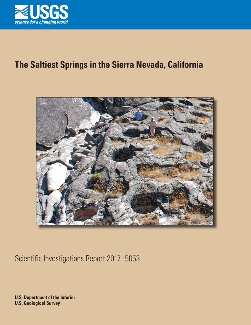
Cover. Photograph of more than a dozen salt-evaporation basins at Hams salt spring, which have been carved by Native Americans in granitic bedrock. Saline water flows in light-colored streambed on left. Photograph by J.S. Moore, 2009.
The Saltiest Springs in the Sierra Nevada, California
By James G. Moore, Michael F. Diggles, William C. Evans, and Karin Klemic
Scientific Investigations Report 2017–5053
U.S. Department of the InteriorU.S. Geological Survey
U.S. Department of the InteriorRYAN K. ZINKE, Secretary
U.S. Geological SurveyWilliam H. Werkheiser, Acting Director
U.S. Geological Survey, Reston, Virginia: 2017
For more information on the USGS—the Federal source for science about the Earth, its natural and living resources, natural hazards, and the environment—visit http://www.usgs.gov or call 1–888–ASK–USGS.
For an overview of USGS information products, including maps, imagery, and publications, visit http://store.usgs.gov.
Any use of trade, firm, or product names is for descriptive purposes only and does not imply endorsement by the U.S. Government.
Although this information product, for the most part, is in the public domain, it also may contain copyrighted materials as noted in the text. Permission to reproduce copyrighted items must be secured from the copyright owner.
Suggested citation:Moore, J.G., Diggles, M.F., Evans, W.C., and Klemic, K., 2017, The saltiest springs in the Sierra Nevada, California: U.S. Geological Survey Scientific Investigations Report 2017–5053, 21 p., 2 appendixes, https://doi.org/10.3133/sir20175053.
ISSN 2328-0328 (online)
iii
Acknowledgments
The areas in the northern Sierra Nevada that contain the salty springs were once occupied by Native Americans, primarily by the Miwok Tribe but also occasionally by the Washoe Tribe, who were mostly centered east of the Sierra Nevada but who crossed the range crest to visit the springs. The area is now administered by the U.S. Forest Service as Eldorado National Forest and Stanislaus National Forest, and we wish to thank the supervisors of these national forests for authorizing this research. The help and support of managers, scientists, and volunteers from these agencies is gratefully acknowledged, especially Karen Bucher, Bob Graham, Lester Kubetkin, and Kyle Johnson, of Eldorado National Forest, and Kathy Strain, Marilyn Meyer, and Edward Berry, of Stanislaus National Forest.
We wish to thank Robert Mariner, for water collection and discussions of water origin; Michael Anderson, for low-level aerial photographs; Mark Castro, for information on spring locations; Barry Moring, for help with base maps; and Karen Sundback, for fieldwork and water collect-ing. Analyses of anions were by Mark Huebner, cations by Deb Bergfeld, and B and Sr isotopes by John Fitzpatrick—all with the USGS in Menlo Park, Calif. Analyses of δD and δ18O were conducted at the USGS Stable Isotope Laboratory in Reston, Va. We are indebted to Jacob Lowenstern (USGS) and Yousif Kharaka (USGS) for their constructive technical reviews, and to Taryn Lindquist (USGS) for her editorial help; this assistance has certainly improved the manuscript.
iv
Contents
Acknowledgments ........................................................................................................................................iiiAbstract ...........................................................................................................................................................1Introduction.....................................................................................................................................................1History .............................................................................................................................................................3Previous Work ................................................................................................................................................4Methods...........................................................................................................................................................4Saline Springs.................................................................................................................................................8
Hams Salt Spring...................................................................................................................................8Fo Owa Spring .......................................................................................................................................8Unabi Marmota Spring .........................................................................................................................9White Hall Springs ..............................................................................................................................10Indian Spring........................................................................................................................................12
Spring-Water Compositions .......................................................................................................................13Origin of Saline Waters ...............................................................................................................................13Conclusions...................................................................................................................................................15References Cited..........................................................................................................................................15Appendix 1.....................................................................................................................................................18Appendix 2.....................................................................................................................................................21
Figures
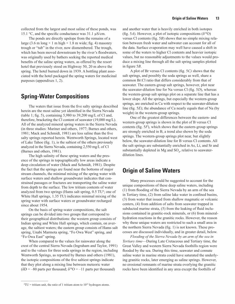
1. Geologic map of part of northern Sierra Nevada, showing approximate locations of five saltiest springs, most of which are associated with bedrock basins excavated by Native Americans to evaporate salt .................................................................2
2. Graph of topographic profiles of three canyons in Sierra Nevada, showing locations of saline springs, low in canyon bottoms ................................................................3
3. Photograph of large basin at White Hall springs on south side of South Fork American River, showing mortar walls built to increase capacity .......................................3
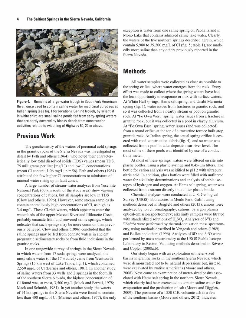
4. Photograph showing remains of large water trough in South Fork American River, once used to contain saline water for medicinal purposes at Indian spring ..........4
5. Graphs showing compositions of two groups (eastern and western) of saline springs, three nearby soda springs, and seawater ................................................................5
6. Aerial photograph of canyon of North Fork Mokelumne River, showing 63 meter- sized basins at Hams salt spring. ...............................................................................................8
7. Sketch map showing two Fo Owa springs (“Fo Owa West” and “Fo Owa East”) on unnamed stream near Caples Creek ....................................................................................9
8. Photograph showing pool of saline water in red mud at “Fo Owa West” spring ..............9 9. Photograph showing large basin excavated in granodiorite near “Fo Owa West”
spring ..............................................................................................................................................9 10. Photograph showing travertine mound at “Fo Owa East” spring ......................................10 11. Sketch map overlay on satellite image of Unabi Marmota spring near
Caples Creek ................................................................................................................................10
v
12. Photograph showing subhorizontal fractures that bound exfoliating granite sheets exposed in walls of basin “D” at Unabi Marmota spring ........................................11
13. Sketch map overlay on satellite image of White Hall springs ............................................11 14. Photograph showing White Hall springs on north side of South Fork
American River ............................................................................................................................12 15. Photograph showing view to east of White Hall springs and five basins on
north side of South Fork American River ................................................................................12 16. Plot of average diameter versus depth for basins at Hams salt spring and
White Hall springs ......................................................................................................................12
Table
1. Chemical and isotopic compositions of saline spring waters in western and eastern salt-spring groups, of seawater, and of waters in selected soda springs in northern Sierra Nevada ...............................................................................................................................6


AbstractThe five saltiest springs in the Sierra Nevada in California
are found between 38.5° and 38.8° N. latitude, on the South Fork American River; on Caples Creek, a tributary of the Silver Fork American River; and on the North Fork Moke-lumne River. The springs issue from Cretaceous granitic rocks in the bottoms of these major canyons, between 1,200- and 2,200-m elevation. All of these springs were well known to Native Americans, who excavated meter-sized basins in the granitic rock, within which they produced salt by evaporation near at least four of the five spring sites. The spring waters are dominated by Cl, Na, and Ca; are enriched relative to seawater in Ca, Li, and As; and are depleted in SO4, Mg, and K. Tritium analyses indicate that the spring waters have had little interaction with rainfall since about 1954. The waters are apparently an old groundwater of meteoric origin that resided at depth before moving up along fractures to the surface of the exhumed granitic rocks. However, along the way these waters incorporated salts from depth, the origin of which could have been either from marine sedimentary rocks intruded by the granitic magmas or from fluid inclusions in the granitic rocks. Prolonged storage at depth fostered water-rock interactions that undoubtedly modified the fluid compositions.
IntroductionFive saline springs, which discharge the saltiest waters
yet analyzed in the Sierra Nevada in California, are found in a north-south-trending span, 40 kilometers (km) long, in the northern part of the range, between 38.5° and 38.8° N. latitude. Although the springs issue from Cretaceous granitic
rocks (fig. 1) at relatively high elevations (1,200–2,200 meters [m]), they all are found3 near the bottoms of glacially carved canyons, only a few meters in elevation above the streams that drain the canyons (fig. 2). White Hall springs and Indian spring are on the South Fork American River; Fo Owa spring and Unabi Marmota spring are on Caples Creek, a tributary of the Silver Fork American River; and Hams salt spring is on the North Fork Mokelumne River. None of the springs is hot: the waters range in temperature from 7.2 to 21 °C.
Because the salt springs are found in topographically low sites, commonly in canyon bottoms near streams or rivers (fig. 2), many saline springs probably have not been recog-nized because they issue from fractures in bedrock beneath fresh-water streams. For example, the presence of White Hall springs on both sides of the South Fork American River, 40 m apart, indicates that the rising water followed the fractures that provided surface egress, and so it probably also issues from bedrock beneath the river.
Basins carved in granitic bedrock are associated with several of these saline springs, which supports the contention that the basins are not naturally occurring but, instead, have been artificially constructed by Native Americans to utilize the salty springs (Moore and others, 2012). The only salty spring where basins are not apparent is Indian spring on Highway 50; however, there the terrain has been so modified by road-construction activities that the original character of the spring is obscured.
The Native Americans who discovered these salt springs made summer camps near them to gather salt. They exca-vated numerous meter-sized basins in bedrock adjacent to at least four of the five saltiest springs, and the basins served as evaporation pans to produce salt. A large number (>1,000) of basins similarly excavated by Native Americans have been mapped in the southern Sierra Nevada, in a 360-km-long belt that stretches from 37.5° to 35.5° N. latitude (Moore and oth-ers, 2008). However, none of the southern basins is associ-ated with salt springs or springs of any kind, and most are in locally elevated sites rather than in low parts of canyons, as the northern salt springs are. The southern basins apparently were constructed to store fresh water for camp use (Moore and others, 2012).
1U.S. Geological Survey.2U.S. Forest Service.3Note that these springs are located on land administered by the U.S. For-
est Service; however, because of their archaeologically sensitive nature, the precise locations of the springs have been omitted here, in accordance with the Archaeological Resources Protection Act of 1979 (16 U.S.C. 470). In addition, the location restrictions imposed by this legislation preclude the dissemination of geospatial data on these springs.
The Saltiest Springs in the Sierra Nevada, California
By James G. Moore,1 Michael F. Diggles,1 William C. Evans,1 and Karin Klemic2
2 The Saltiest Springs in the Sierra Nevada, California
South Fork American
American
River
River
North
Silver
Fork
Fork
Mokelumne River
Middle ForkConsumnes
River
Caples Creek
•
•••
•
••
HAMS SALTSPRING
FO OWA SPRINGUNABI MARMOTASPRING
WHITE HALL SPRINGS
INDIAN SPRING
�gr
�gr
�gr
�gr
Tvp
�
J
Tvp
Tvp
Qg
Q
Tvp�
J
Qg
�
Tvp
Tvp
Tvp
Tvp
Tvp
Qg
�
Tvp
�gr
Tvp
}gr
gr-m
J
�v
Qg
Tvp
�
Qg
}gr
Tvp
�gr
Tvp
J
Tvp
Tvp
Tvp
Qg
�
Qg
Qv
Qg
Qg
�gr
�gr
�gr�gr
�gr
�gr
Qg
gb
Qv
Qg
Tvp
120°120°15'120°30'
39°
38°45'
38°30'
WENTWORTHSPRINGS RUBICON SODA
SPRINGS
GLEN ALPINESODA SPRINGS
Kyburz
CALIFORNIA
50
0 10 20 KILOMETERS
0 5 10 MILES
Area of map
Lake Tahoe
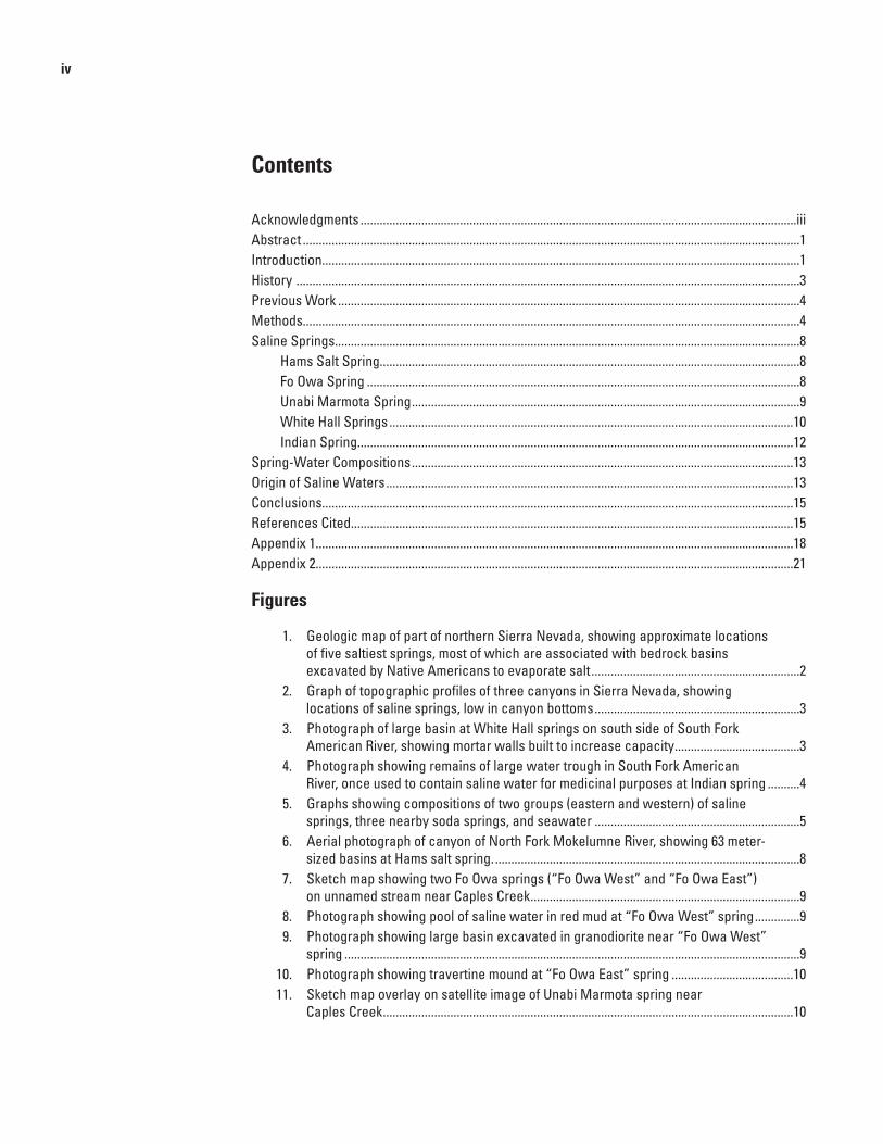
Figure 1. Geologic map of part of northern Sierra Nevada (modified from Wagner and others, 1981), showing approximate locations of five saltiest springs (black circles), most of which are associated with bedrock basins excavated by Native Americans to evaporate salt. Red circles show locations of three nearest known soda springs. Unlabeled light-blue areas are lakes. Map symbols, map units, and map colors (in parentheses), listed oldest to youngest: |, Paleozoic metamorphic rocks (green); }gr, Mesozoic granitic rocks (pink); }v, Mesozoic volcanic rocks (light red); J, Jurassic metamorphic rocks (medium blue); gr-m, mixed granitic and metamorphic rocks (light blue); Tvp, Tertiary volcanic rocks (medium red); Qv, Quaternary volcanic rocks (bright red); Qg, Quaternary glacial deposits (light yellow); Q, Quaternary alluvium and glacial deposits (dark yellow).
History 3
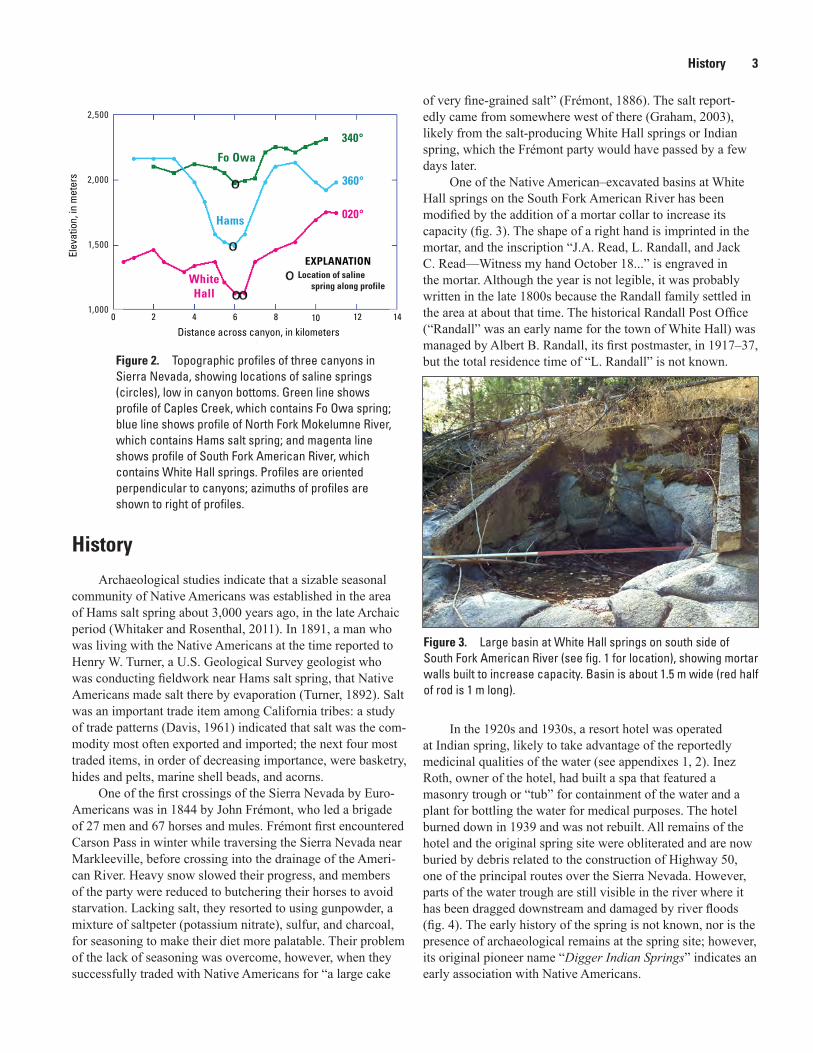
HistoryArchaeological studies indicate that a sizable seasonal
community of Native Americans was established in the area of Hams salt spring about 3,000 years ago, in the late Archaic period (Whitaker and Rosenthal, 2011). In 1891, a man who was living with the Native Americans at the time reported to Henry W. Turner, a U.S. Geological Survey geologist who was conducting fieldwork near Hams salt spring, that Native Americans made salt there by evaporation (Turner, 1892). Salt was an important trade item among California tribes: a study of trade patterns (Davis, 1961) indicated that salt was the com-modity most often exported and imported; the next four most traded items, in order of decreasing importance, were basketry, hides and pelts, marine shell beads, and acorns.
One of the first crossings of the Sierra Nevada by Euro-Americans was in 1844 by John Frémont, who led a brigade of 27 men and 67 horses and mules. Frémont first encountered Carson Pass in winter while traversing the Sierra Nevada near Markleeville, before crossing into the drainage of the Ameri-can River. Heavy snow slowed their progress, and members of the party were reduced to butchering their horses to avoid starvation. Lacking salt, they resorted to using gunpowder, a mixture of saltpeter (potassium nitrate), sulfur, and charcoal, for seasoning to make their diet more palatable. Their problem of the lack of seasoning was overcome, however, when they successfully traded with Native Americans for “a large cake
of very fine-grained salt” (Frémont, 1886). The salt report-edly came from somewhere west of there (Graham, 2003), likely from the salt-producing White Hall springs or Indian spring, which the Frémont party would have passed by a few days later.
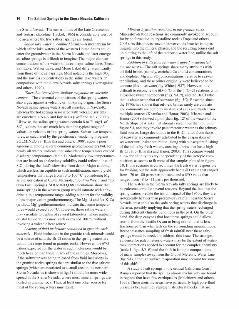
One of the Native American–excavated basins at White Hall springs on the South Fork American River has been modified by the addition of a mortar collar to increase its capacity (fig. 3). The shape of a right hand is imprinted in the mortar, and the inscription “J.A. Read, L. Randall, and Jack C. Read—Witness my hand October 18...” is engraved in the mortar. Although the year is not legible, it was probably written in the late 1800s because the Randall family settled in the area at about that time. The historical Randall Post Office (“Randall” was an early name for the town of White Hall) was managed by Albert B. Randall, its first postmaster, in 1917–37, but the total residence time of “L. Randall” is not known.
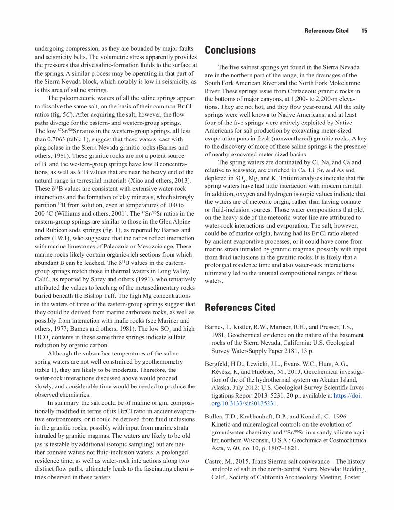
In the 1920s and 1930s, a resort hotel was operated at Indian spring, likely to take advantage of the reportedly medicinal qualities of the water (see appendixes 1, 2). Inez Roth, owner of the hotel, had built a spa that featured a masonry trough or “tub” for containment of the water and a plant for bottling the water for medical purposes. The hotel burned down in 1939 and was not rebuilt. All remains of the hotel and the original spring site were obliterated and are now buried by debris related to the construction of Highway 50, one of the principal routes over the Sierra Nevada. However, parts of the water trough are still visible in the river where it has been dragged downstream and damaged by river floods (fig. 4). The early history of the spring is not known, nor is the presence of archaeological remains at the spring site; however, its original pioneer name “Digger Indian Springs” indicates an early association with Native Americans.
Elev
atio
n, in
met
ers
Location of saline spring along profile
Fo Owa
340°
Hams
360°
WhiteHall
020°
Distance across canyon, in kilometers
EXPLANATION
2,500
2,000
1,500
1,0000 2 4 6 8 10 12 14
Figure 2. Topographic profiles of three canyons in Sierra Nevada, showing locations of saline springs (circles), low in canyon bottoms. Green line shows profile of Caples Creek, which contains Fo Owa spring; blue line shows profile of North Fork Mokelumne River, which contains Hams salt spring; and magenta line shows profile of South Fork American River, which contains White Hall springs. Profiles are oriented perpendicular to canyons; azimuths of profiles are shown to right of profiles.
Figure 3. Large basin at White Hall springs on south side of South Fork American River (see fig. 1 for location), showing mortar walls built to increase capacity. Basin is about 1.5 m wide (red half of rod is 1 m long).
4 The Saltiest Springs in the Sierra Nevada, California
Previous WorkThe geochemistry of the waters of perennial cold springs
in the granitic rocks of the Sierra Nevada was investigated in detail by Feth and others (1964), who noted their character-istically low total dissolved solids (TDS) values (mean TDS, 75 milligrams per liter [mg/L]) and low Cl concentrations (mean Cl content, 1.06 mg/L; n = 56). Feth and others (1964) attributed the few higher Cl concentrations to admixture of mineral water rising up in fault zones.
A large number of stream-water analyses from Yosemite National Park (60 km south of the study area) show varying concentrations of cations, but all samples are low in TDS (Clow and others, 1996). However, some stream samples do contain anomalously high concentrations of Cl, as high as 3.4 mg/L. These Cl-rich waters, which appear to enter the watersheds of the upper Merced River and Illilouette Creek, probably emanate from undiscovered saline springs, which indicates that such springs may be more common than previ-ously believed. Clow and others (1996) concluded that the saline springs may be fed from connate waters in ancient pregranitic sedimentary rocks or from fluid inclusions in the granitic rocks.
In one rangewide survey of springs in the Sierra Nevada, in which waters from 17 soda springs were analyzed, the most saline water (of the 17 studied) came from Wentworth Springs (15 km west of Lake Tahoe; fig. 1), which contained 2,550 mg/L of Cl (Barnes and others, 1981). In another study of saline waters from 33 wells and 2 springs in the foothills of the southern Sierra Nevada, the highest concentration of Cl found was, at most, 3,500 mg/L (Mack and Ferrell, 1978; Mack and Schmidt, 1981). In yet another study, the waters of 14 hot springs in the Sierra Nevada were found to contain less than 400 mg/L of Cl (Mariner and others, 1977); the only
exception is water from one saline spring on Paoha Island in Mono Lake that contains admixed saline lake water. Clearly, the waters of the five northern springs described herein, which contain 5,980 to 39,200 mg/L of Cl (fig. 5; table 1), are mark-edly more saline than any others previously reported in the Sierra Nevada.
MethodsAll water samples were collected as close as possible to
the spring orifice, where water emerges from the rock. Every effort was made to collect where the spring waters have had the least opportunity to evaporate or mix with surface waters. At White Hall springs, Hams salt spring, and Unabi Marmota spring (fig. 1), water issues from fractures in granitic rock, and so it was collected from a nearby stream or pool on granitic rock. At “Fo Owa West” spring, water issues from a fracture in granitic rock, but it was collected in a pool in clayey alluvium. At “Fo Owa East” spring, water issues (and was collected) from a round orifice at the top of a travertine terrace built atop granitic rock. At Indian spring, the actual spring orifice is cov-ered with road-construction debris (fig. 4), and so water was collected from a pool in talus deposits near river level. The most saline of these pools was identified by use of a conduc-tivity meter.
At most of these springs, waters were filtered on site into plastic bottles, using a plastic syringe and 0.45-μm filters. The bottle for cation analysis was acidified to pH 2 with ultrapure nitric acid. In addition, glass bottles were filled with unfiltered water for alkalinity determinations and analysis of stable iso-topes of hydrogen and oxygen. At Hams salt spring, water was collected from a stream directly into a liter plastic bottle.
Chemical analyses were conducted at U.S. Geological Survey (USGS) laboratories in Menlo Park, Calif., using methods described in Bergfeld and others (2013): anions were analyzed by ion chromatography; cations, by argon plasma optical-emission spectrometry; alkalinity samples were titrated with standardized solutions of H2SO4. Analyses of δ11B and 87Sr/86Sr were performed by thermal-ionization mass spectrom-etry, using methods described in Vengosh and others (1989) and Bullen and others (1996). Analyses of δD and δ18O were performed by mass spectrometry at the USGS Stable Isotope Laboratory in Reston, Va., using methods described in Révész and Coplen (2008a,b).
Our study began with an exploration of meter-sized basins in granitic rocks in the southern Sierra Nevada, which were demonstrated not to be natural depressions but, instead, were excavated by Native Americans (Moore and others, 2008). Next came an examination of meter-sized basins asso-ciated with Hams salt spring in the northern Sierra Nevada, which clearly had been excavated to contain saline water for evaporation and the production of salt (Moore and Diggles, 2009). The presence of a 1350 C.E. volcanic ash in a few of the southern basins (Moore and others, 2012) indicates
Figure 4. Remains of large water trough in South Fork American River, once used to contain saline water for medicinal purposes at Indian spring (see fig. 1 for location). Behind trough, by scientist in white shirt, are small saline ponds fed from salty-spring waters that are partly covered by blocky debris from construction activities related to widening of Highway 50, 20 m above.

Methods 5
–120
–100
–80
–60
–40
–20
0
–16 –14 –12 –10 –8 –6 –4 –2 0
Western group
Eastern group
Soda springs
Seawater
A B
C D
E F
EXPLANATION
0
10,000
20,000
30,000
40,000
50,000
–16 –14 –12 –10 –8 –6 –4 –2 0
Cl, i
n m
illig
ram
s pe
r lite
r
δ18O, in parts per thousandδ18O, in parts per thousand
δD, i
n pa
rts
per t
hous
and
0
10
20
30
40
50
60
70
80
0 5,000 10,000 15,000 20,000 25,000 30,000 35,000 40,000 45,000Cl, in milligrams per liter
0 5,000 10,000 15,000 20,000 25,000 30,000 35,000 40,000 45,000Cl, in milligrams per liter
0 5,000 10,000 15,000 20,000 25,000 30,000 35,000 40,000 45,000Cl, in milligrams per liter
0 5,000 10,000 15,000 20,000 25,000 30,000 35,000 40,000 45,000Cl, in milligrams per liter
0
2,000
4,000
6,000
8,000
10,000
12,000
14,000
Ca, i
n m
illig
ram
s pe
r lite
rB
r, in
mill
igra
ms
per l
iter
B, i
n m
illig
ram
s pe
r lite
r
0
2,000
4,000
6,000
8,000
10,000
12,000
14,000
Na,
in m
illig
ram
s pe
r lite
r
0
10
20
30
40
50
60
70
80
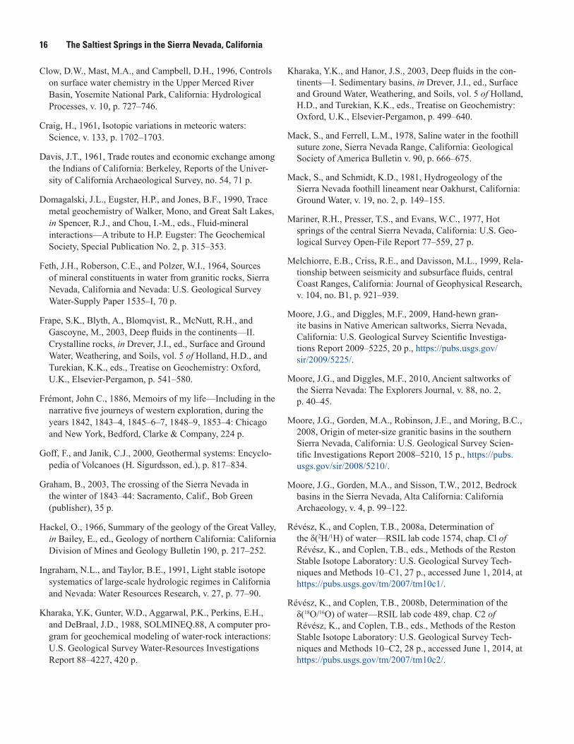
Figure 5. Compositional plots for two groups (eastern and western) of saline springs, three nearby soda springs, and seawater. Compositions of three nearby soda springs (Wentworth Springs, Rubicon soda springs, and Glen Alpine soda springs; see fig. 1 for location) from Barnes and others (1981). Solid black line (in A) shows Global Meteoric Water Line (GMWL) of Craig (1961). Dashed black arrow (in A, C ) shows common trend of saline springs. Green arrow (in C, D, E, F ) shows seawater dilution line. A, δ18O (‰) versus δD (‰). Blue oval shows estimated isotopic composition of present-day rainfall from Ingraham and Taylor (1991). B, δ18O (‰) versus Cl (mg/L). C, Cl (mg/L) versus Br (mg/L). D, Cl (mg/L) versus Na (mg/L). E, Cl (mg/L) versus Ca (mg/L). F, Cl (mg/L) versus B (mg/L).
6 The Saltiest Springs in the Sierra Nevada, California
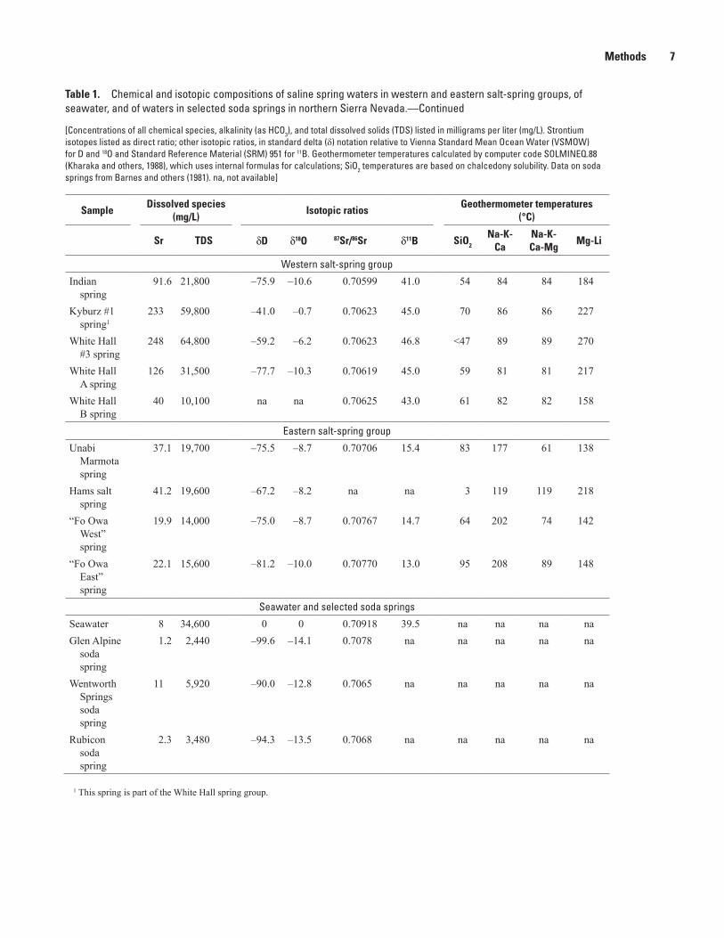
Table 1. Chemical and isotopic compositions of saline spring waters in western and eastern salt-spring groups, of seawater, and of waters in selected soda springs in northern Sierra Nevada.
[Concentrations of all chemical species, alkalinity (as HCO3), and total dissolved solids (TDS) listed in milligrams per liter (mg/L). Strontium isotopes listed as direct ratio; other isotopic ratios, in standard delta () notation relative to Vienna Standard Mean Ocean Water (VSMOW) for D and 18O and Standard Reference Material (SRM) 951 for 11B. Geothermometer temperatures calculated by computer code SOLMINEQ.88 (Kharaka and others, 1988), which uses internal formulas for calculations; SiO2 temperatures are based on chalcedony solubility. Data on soda springs from Barnes and others (1981). na, not available]
SampleDissolved species
(mg/L)
As B Br Ca Cl HCO3 K Li Mg Na SiO2 SO4
Western salt-spring group
Indian spring
0.72 1.92 25 3,710 13,600 86 36.5 12.5 7.65 4,210 30 25
Kyburz #1 spring1
0.9 5.3 63 10,800 35,600 133 92 34 8.3 11,900 34 930
White Hall #3 spring
0.3 5.0 66 11,400 39,200 28 105 36 1.9 12,700 <20 870
White Hall A spring
0.5 2.9 33 5,500 18,960 na 46 17 3.2 6,200 32 590
White Hall B spring
0.2 1.3 11 1,800 5,980 na 18 5.4 5.4 1,930 38 220
Eastern salt-spring group
Unabi Marmota spring
2.5 71.6 14.7 956 10,700 1,630 311 21 260 5,600 56 1.3
Hams salt spring
1.7 45.0 21 1,600 12,000 41 98 19.2 3.9 5,610 8 162
“Fo Owa West” spring
0.24 58.7 9.2 578 6,950 1,430 378 18.6 155 4,310 40 <2
“Fo Owa East” spring
1.0 72.7 10.1 662 7,530 2,060 435 21.4 146 4,510 71 <2
Seawater and selected soda springs
Seawater <0.01 4.44 67 412 18,800 137 380 0.18 1,290 10,800 8.6 2,720Glen Alpine
soda spring
na 4.7 1.3 275 550 1,140 9.5 na 54 350 45 10
Wentworth Springs soda spring
na 14 2.9 500 2,550 1,340 32 na 140 1,250 75 8
Rubicon soda spring
na 8 1.8 260 1,000 1,380 20 na 110 610 78 13
Methods 7
Table 1. Chemical and isotopic compositions of saline spring waters in western and eastern salt-spring groups, of seawater, and of waters in selected soda springs in northern Sierra Nevada.—Continued
[Concentrations of all chemical species, alkalinity (as HCO3), and total dissolved solids (TDS) listed in milligrams per liter (mg/L). Strontium isotopes listed as direct ratio; other isotopic ratios, in standard delta () notation relative to Vienna Standard Mean Ocean Water (VSMOW) for D and 18O and Standard Reference Material (SRM) 951 for 11B. Geothermometer temperatures calculated by computer code SOLMINEQ.88 (Kharaka and others, 1988), which uses internal formulas for calculations; SiO2 temperatures are based on chalcedony solubility. Data on soda springs from Barnes and others (1981). na, not available]
SampleDissolved species
(mg/L)Isotopic ratios
Geothermometer temperatures (°C)
Sr TDS dD d18O 87Sr/86Sr d11B SiO2 Na-K-
CaNa-K- Ca-Mg
Mg-Li
Western salt-spring group
Indian spring
91.6 21,800 –75.9 –10.6 0.70599 41.0 54 84 84 184
Kyburz #1 spring1
233 59,800 –41.0 –0.7 0.70623 45.0 70 86 86 227
White Hall #3 spring
248 64,800 –59.2 –6.2 0.70623 46.8 <47 89 89 270
White Hall A spring
126 31,500 –77.7 –10.3 0.70619 45.0 59 81 81 217
White Hall B spring
40 10,100 na na 0.70625 43.0 61 82 82 158
Eastern salt-spring group
Unabi Marmota spring
37.1 19,700 –75.5 –8.7 0.70706 15.4 83 177 61 138
Hams salt spring
41.2 19,600 –67.2 –8.2 na na 3 119 119 218
“Fo Owa West” spring
19.9 14,000 –75.0 –8.7 0.70767 14.7 64 202 74 142
“Fo Owa East” spring
22.1 15,600 –81.2 –10.0 0.70770 13.0 95 208 89 148
Seawater and selected soda springs
Seawater 8 34,600 0 0 0.70918 39.5 na na na naGlen Alpine
soda spring
1.2 2,440 –99.6 –14.1 0.7078 na na na na na
Wentworth Springs soda spring
11 5,920 –90.0 –12.8 0.7065 na na na na na
Rubicon soda spring
2.3 3,480 –94.3 –13.5 0.7068 na na na na na
1 This spring is part of the White Hall spring group.
8 The Saltiest Springs in the Sierra Nevada, California
that some of those basins had been excavated before the end of the warm Medieval Climate Anomaly (800–1350 C.E.), supporting the supposition that the southern basins had been excavated to contain fresh water to supply mountain camps for prolonged occupation at the end of the summer season. Our study was initiated when archaeological records became avail-able that indicated that more of the saline springs were present north of Hams salt spring (Castro, 2015).
Saline Springs
Hams Salt Spring
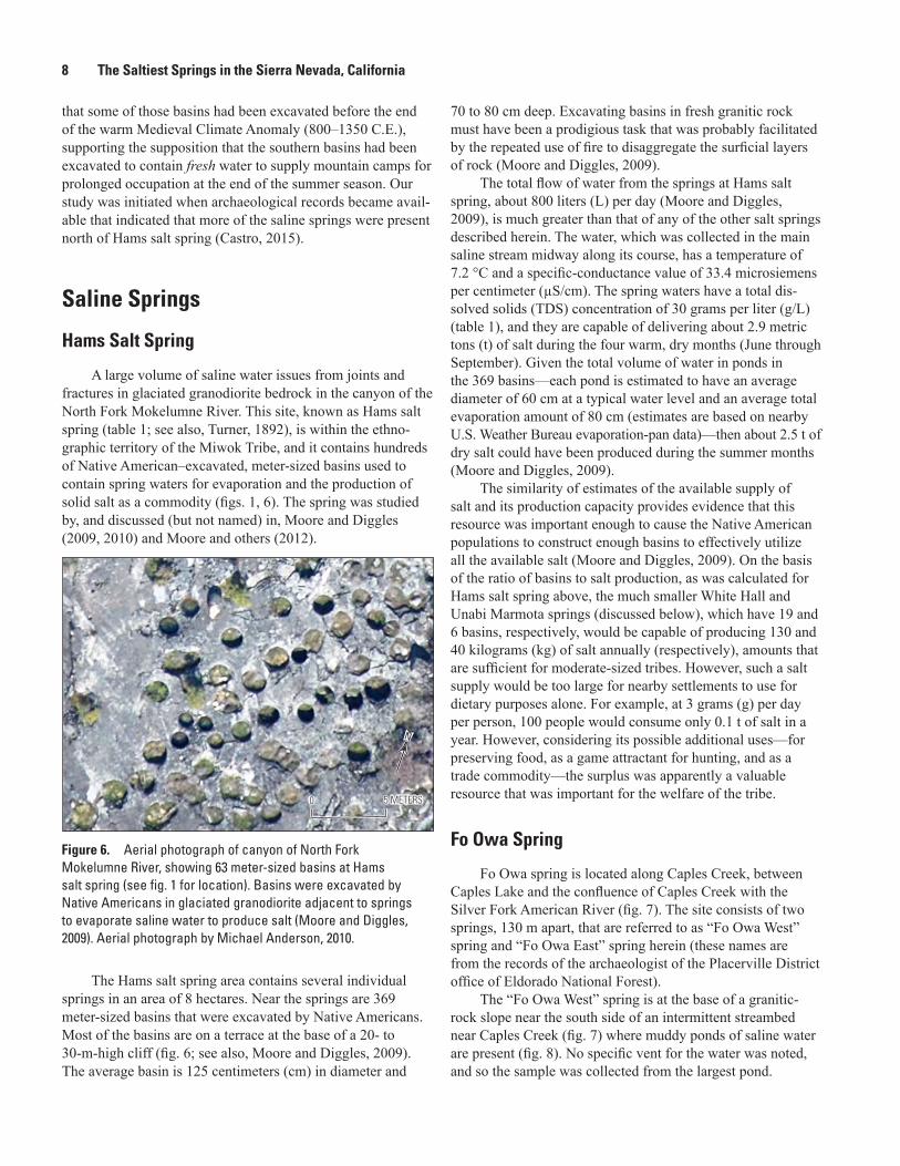
A large volume of saline water issues from joints and fractures in glaciated granodiorite bedrock in the canyon of the North Fork Mokelumne River. This site, known as Hams salt spring (table 1; see also, Turner, 1892), is within the ethno-graphic territory of the Miwok Tribe, and it contains hundreds of Native American–excavated, meter-sized basins used to contain spring waters for evaporation and the production of solid salt as a commodity (figs. 1, 6). The spring was studied by, and discussed (but not named) in, Moore and Diggles (2009, 2010) and Moore and others (2012).
The Hams salt spring area contains several individual springs in an area of 8 hectares. Near the springs are 369 meter-sized basins that were excavated by Native Americans. Most of the basins are on a terrace at the base of a 20- to 30-m-high cliff (fig. 6; see also, Moore and Diggles, 2009). The average basin is 125 centimeters (cm) in diameter and
70 to 80 cm deep. Excavating basins in fresh granitic rock must have been a prodigious task that was probably facilitated by the repeated use of fire to disaggregate the surficial layers of rock (Moore and Diggles, 2009).
The total flow of water from the springs at Hams salt spring, about 800 liters (L) per day (Moore and Diggles, 2009), is much greater than that of any of the other salt springs described herein. The water, which was collected in the main saline stream midway along its course, has a temperature of 7.2 °C and a specific-conductance value of 33.4 microsiemens per centimeter (µS/cm). The spring waters have a total dis-solved solids (TDS) concentration of 30 grams per liter (g/L) (table 1), and they are capable of delivering about 2.9 metric tons (t) of salt during the four warm, dry months (June through September). Given the total volume of water in ponds in the 369 basins—each pond is estimated to have an average diameter of 60 cm at a typical water level and an average total evaporation amount of 80 cm (estimates are based on nearby U.S. Weather Bureau evaporation-pan data)—then about 2.5 t of dry salt could have been produced during the summer months (Moore and Diggles, 2009).
The similarity of estimates of the available supply of salt and its production capacity provides evidence that this resource was important enough to cause the Native American populations to construct enough basins to effectively utilize all the available salt (Moore and Diggles, 2009). On the basis of the ratio of basins to salt production, as was calculated for Hams salt spring above, the much smaller White Hall and Unabi Marmota springs (discussed below), which have 19 and 6 basins, respectively, would be capable of producing 130 and 40 kilograms (kg) of salt annually (respectively), amounts that are sufficient for moderate-sized tribes. However, such a salt supply would be too large for nearby settlements to use for dietary purposes alone. For example, at 3 grams (g) per day per person, 100 people would consume only 0.1 t of salt in a year. However, considering its possible additional uses—for preserving food, as a game attractant for hunting, and as a trade commodity—the surplus was apparently a valuable resource that was important for the welfare of the tribe.
Fo Owa Spring
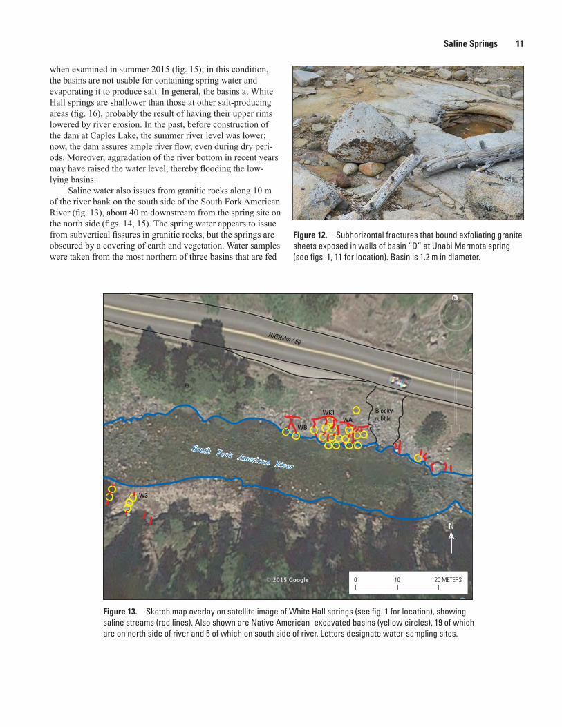
Fo Owa spring is located along Caples Creek, between Caples Lake and the confluence of Caples Creek with the Silver Fork American River (fig. 7). The site consists of two springs, 130 m apart, that are referred to as “Fo Owa West” spring and “Fo Owa East” spring herein (these names are from the records of the archaeologist of the Placerville District office of Eldorado National Forest).
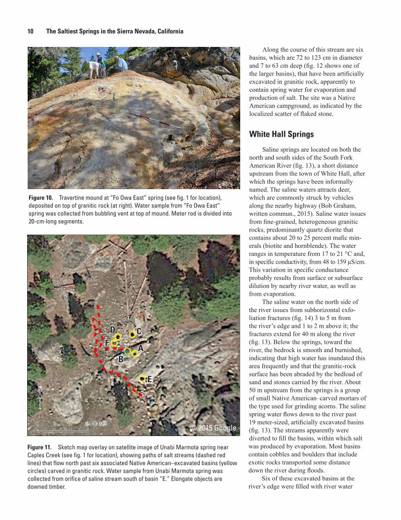
The “Fo Owa West” spring is at the base of a granitic-rock slope near the south side of an intermittent streambed near Caples Creek (fig. 7) where muddy ponds of saline water are present (fig. 8). No specific vent for the water was noted, and so the sample was collected from the largest pond.
0 5 METERS0 5 METERS
NN
Figure 6. Aerial photograph of canyon of North Fork Mokelumne River, showing 63 meter-sized basins at Hams salt spring (see fig. 1 for location). Basins were excavated by Native Americans in glaciated granodiorite adjacent to springs to evaporate saline water to produce salt (Moore and Diggles, 2009). Aerial photograph by Michael Anderson, 2010.
Saline Springs 9
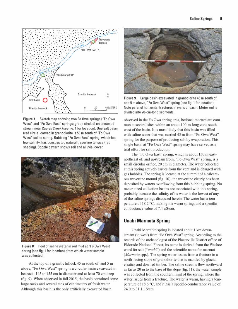
At the top of a granitic hillock 45 m south of, and 5 m above, “Fo Owa West” spring is a circular basin excavated in bedrock, 145 to 155 cm in diameter and at least 70 cm deep (fig. 9). When observed in fall 2015, the basin contained some large rocks and several tens of centimeters of fresh water. Although this basin is the only artificially excavated basin
observed in the Fo Owa spring area, bedrock mortars are com-mon at several sites within an about 100-m-long zone south-west of the basin. It is most likely that this basin was filled with saline water that was carried 45 m from “Fo Owa West” spring for the purpose of producing salt by evaporation. This single basin at “Fo Owa West” spring may have served as a trial effort for salt production.
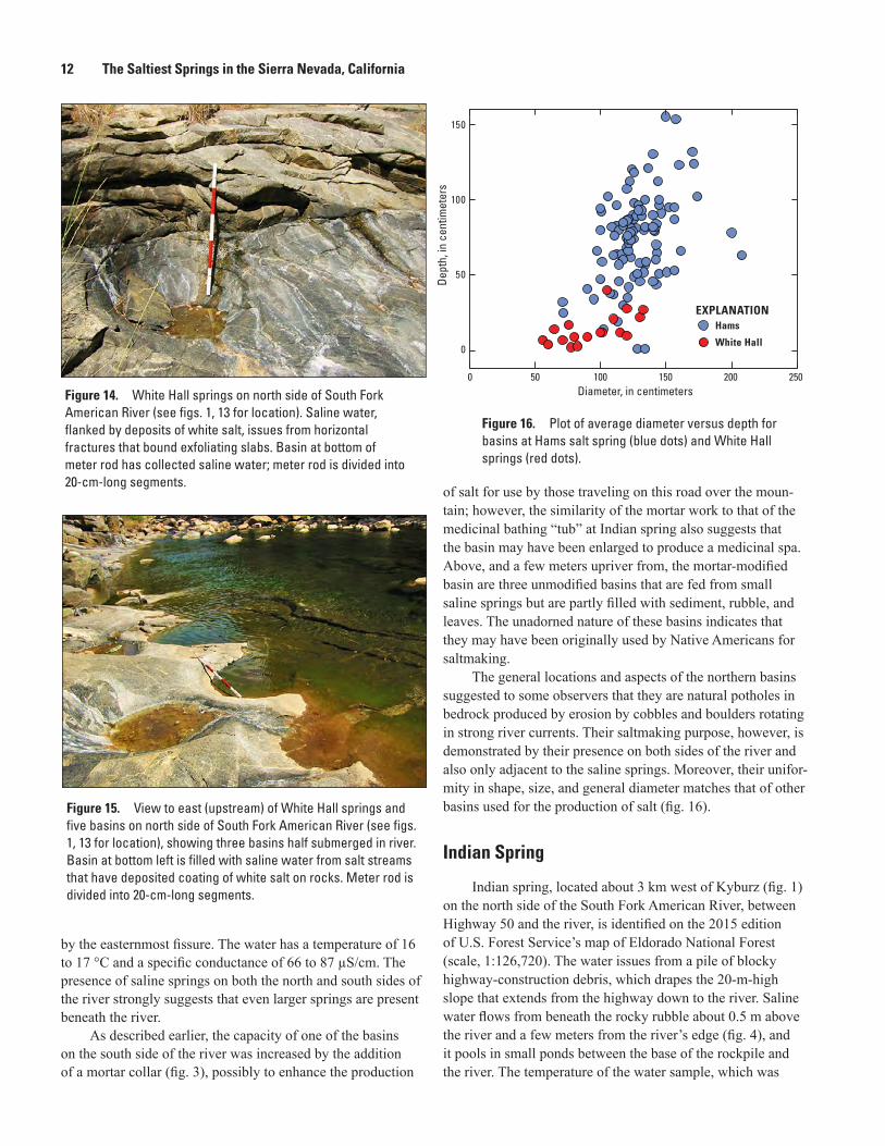
The “Fo Owa East” spring, which is about 130 m east-northeast of, and upstream from, “Fo Owa West” spring, is a small circular orifice, 20 cm in diameter. The water collected at this spring actively issues from the vent and is charged with gas bubbles. The spring is located at the summit of a calcare-ous travertine mound (fig. 10); the travertine clearly has been deposited by waters overflowing from this bubbling spring. No meter-sized collection basins are associated with this spring, probably because the salinity of its water is the lowest of any of the saline springs discussed herein. The water has a tem-perature of 18.2 °C, making it a warm spring, and a specific-conductance value of 7.4 µS/cm.
Unabi Marmota Spring
Unabi Marmota spring is located about 1 km down-stream (to west) from “Fo Owa West” spring. According to the records of the archaeologist of the Placerville District office of Eldorado National Forest, its name is derived from the Washoe word for salt (“unabi”) and the scientific name for marmot (Marmota spp.). The spring water issues from a fracture in a north-facing slope of granodiorite that is mantled by glacial erratics and downed timber. The saline streams flow northward as far as 20 m to the base of the slope (fig. 11); the water sample was collected from the southern limit of the spring, where the water issues from a fracture. The water is warm, having a tem-perature of 18.6 °C, and it has a specific-conductance value of 24.0 to 31.1 µS/cm.
0 20 40 METERS
Unnamed
stream
Travertineterrace
“FO OWA WEST”
“FO OWA EAST”
Salt basin
Granitic bedrock
Granitic bedrock
N
Figure 7. Sketch map showing two Fo Owa springs (“Fo Owa West” and “Fo Owa East” springs; green circles) on unnamed stream near Caples Creek (see fig. 1 for location). One salt basin (red circle) carved in granodiorite is 50 m south of “Fo Owa West” saline spring. Bubbling “Fo Owa East” spring, which has low salinity, has constructed natural travertine terrace (red shading). Stipple pattern shows soil and alluvial cover.
Figure 8. Pool of saline water in red mud at “Fo Owa West” spring (see fig. 1 for location), from which water sample was collected.
Figure 9. Large basin excavated in granodiorite 45 m south of, and 5 m above, “Fo Owa West” spring (see fig. 1 for location). Note parallel horizontal fractures in walls of basin. Meter rod is divided into 20-cm-long segments.
10 The Saltiest Springs in the Sierra Nevada, California
Along the course of this stream are six basins, which are 72 to 123 cm in diameter and 7 to 63 cm deep (fig. 12 shows one of the larger basins), that have been artificially excavated in granitic rock, apparently to contain spring water for evaporation and production of salt. The site was a Native American campground, as indicated by the localized scatter of flaked stone.
White Hall Springs
Saline springs are located on both the north and south sides of the South Fork American River (fig. 13), a short distance upstream from the town of White Hall, after which the springs have been informally named. The saline waters attracts deer, which are commonly struck by vehicles along the nearby highway (Bob Graham, written commun., 2015). Saline water issues from fine-grained, heterogeneous granitic rocks, predominantly quartz diorite that contains about 20 to 25 percent mafic min-erals (biotite and hornblende). The water ranges in temperature from 17 to 21 °C and, in specific conductivity, from 48 to 159 µS/cm. This variation in specific conductance probably results from surface or subsurface dilution by nearby river water, as well as from evaporation.
The saline water on the north side of the river issues from subhorizontal exfo-liation fractures (fig. 14) 3 to 5 m from the river’s edge and 1 to 2 m above it; the fractures extend for 40 m along the river (fig. 13). Below the springs, toward the river, the bedrock is smooth and burnished, indicating that high water has inundated this area frequently and that the granitic-rock surface has been abraded by the bedload of sand and stones carried by the river. About 50 m upstream from the springs is a group of small Native American–carved mortars of the type used for grinding acorns. The saline spring water flows down to the river past 19 meter-sized, artificially excavated basins (fig. 13). The streams apparently were diverted to fill the basins, within which salt was produced by evaporation. Most basins contain cobbles and boulders that include exotic rocks transported some distance down the river during floods.
Six of these excavated basins at the river’s edge were filled with river water
Figure 10. Travertine mound at “Fo Owa East” spring (see fig. 1 for location), deposited on top of granitic rock (at right). Water sample from “Fo Owa East” spring was collected from bubbling vent at top of mound. Meter rod is divided into 20-cm-long segments.
Figure 11. Sketch map overlay on satellite image of Unabi Marmota spring near Caples Creek (see fig. 1 for location), showing paths of salt streams (dashed red lines) that flow north past six associated Native American–excavated basins (yellow circles) carved in granitic rock. Water sample from Unabi Marmota spring was collected from orifice of saline stream south of basin “E.” Elongate objects are downed timber.
10 15 METERS50 10 15 METERS50
A F
BB
CD
E
A FCD
ENN
© 2015 Google
Saline Springs 11
when examined in summer 2015 (fig. 15); in this condition, the basins are not usable for containing spring water and evaporating it to produce salt. In general, the basins at White Hall springs are shallower than those at other salt-producing areas (fig. 16), probably the result of having their upper rims lowered by river erosion. In the past, before construction of the dam at Caples Lake, the summer river level was lower; now, the dam assures ample river flow, even during dry peri-ods. Moreover, aggradation of the river bottom in recent years may have raised the water level, thereby flooding the low-lying basins.
Saline water also issues from granitic rocks along 10 m of the river bank on the south side of the South Fork American River (fig. 13), about 40 m downstream from the spring site on the north side (figs. 14, 15). The spring water appears to issue from subvertical fissures in granitic rocks, but the springs are obscured by a covering of earth and vegetation. Water samples were taken from the most northern of three basins that are fed
Figure 12. Subhorizontal fractures that bound exfoliating granite sheets exposed in walls of basin “D” at Unabi Marmota spring (see figs. 1, 11 for location). Basin is 1.2 m in diameter.
Figure 13. Sketch map overlay on satellite image of White Hall springs (see fig. 1 for location), showing saline streams (red lines). Also shown are Native American–excavated basins (yellow circles), 19 of which are on north side of river and 5 of which on south side of river. Letters designate water-sampling sites.
⊕
HIGHWAY 50
South Fork American River
Blockyrubble
WK1WA
WB
W3
South Fork American River
N
0 10 20 METERS
12 The Saltiest Springs in the Sierra Nevada, California
by the easternmost fissure. The water has a temperature of 16 to 17 °C and a specific conductance of 66 to 87 µS/cm. The presence of saline springs on both the north and south sides of the river strongly suggests that even larger springs are present beneath the river.
As described earlier, the capacity of one of the basins on the south side of the river was increased by the addition of a mortar collar (fig. 3), possibly to enhance the production
of salt for use by those traveling on this road over the moun-tain; however, the similarity of the mortar work to that of the medicinal bathing “tub” at Indian spring also suggests that the basin may have been enlarged to produce a medicinal spa. Above, and a few meters upriver from, the mortar-modified basin are three unmodified basins that are fed from small saline springs but are partly filled with sediment, rubble, and leaves. The unadorned nature of these basins indicates that they may have been originally used by Native Americans for saltmaking.
The general locations and aspects of the northern basins suggested to some observers that they are natural potholes in bedrock produced by erosion by cobbles and boulders rotating in strong river currents. Their saltmaking purpose, however, is demonstrated by their presence on both sides of the river and also only adjacent to the saline springs. Moreover, their unifor-mity in shape, size, and general diameter matches that of other basins used for the production of salt (fig. 16).
Indian Spring
Indian spring, located about 3 km west of Kyburz (fig. 1) on the north side of the South Fork American River, between Highway 50 and the river, is identified on the 2015 edition of U.S. Forest Service’s map of Eldorado National Forest (scale, 1:126,720). The water issues from a pile of blocky highway-construction debris, which drapes the 20-m-high slope that extends from the highway down to the river. Saline water flows from beneath the rocky rubble about 0.5 m above the river and a few meters from the river’s edge (fig. 4), and it pools in small ponds between the base of the rockpile and the river. The temperature of the water sample, which was
Dept
h, in
cen
timet
ers
Hams
White Hall
EXPLANATION
150
100
50
0
250200150100500Diameter, in centimeters
Figure 16. Plot of average diameter versus depth for basins at Hams salt spring (blue dots) and White Hall springs (red dots).
Figure 14. White Hall springs on north side of South Fork American River (see figs. 1, 13 for location). Saline water, flanked by deposits of white salt, issues from horizontal fractures that bound exfoliating slabs. Basin at bottom of meter rod has collected saline water; meter rod is divided into 20-cm-long segments.
Figure 15. View to east (upstream) of White Hall springs and five basins on north side of South Fork American River (see figs. 1, 13 for location), showing three basins half submerged in river. Basin at bottom left is filled with saline water from salt streams that have deposited coating of white salt on rocks. Meter rod is divided into 20-cm-long segments.
Origin of Saline Waters 13
collected from the largest and most saline of these ponds, was 15.1 °C, and the specific conductance was 31.1 µS/cm.
The ponds are directly upslope from the remains of a large (3.6 m long × 1 m high × 1.8 m wide; fig. 4) masonry trough or “tub” in the river, now dismembered. The trough, which has been moved downstream by the river’s floodwaters, was originally used by bathers seeking the reported medical benefits of the saline spring waters, as offered by the resort hotel that previously stood on Highway 50, 20 m above the spring. The hotel burned down in 1939. A bottling plant asso-ciated with the hotel packaged the spring waters for medicinal purposes (appendixes 1, 2).
Spring-Water CompositionsThe waters that issue from the five salty springs described
herein are the most saline yet identified in the Sierra Nevada (table 1; fig. 5), containing 5,980 to 39,200 mg/L of Cl and, therefore, bracketing the Cl content of seawater (19,000 mg/L). All of the analyzed mineral spring waters in the Sierra Nevada (in three studies: Mariner and others, 1977; Barnes and others, 1981; Mack and Schmidt, 1981) are less saline than the five salty springs reported herein. Wentworth Springs, located west of Lake Tahoe (fig. 1), is the saltiest of the others previously analyzed in the Sierra Nevada, containing 2,550 mg/L of Cl (Barnes and others, 1981).
The high salinity of these spring waters and the pres-ence of the springs in topographically low areas indicate a deep circulation of water (Mack and Schmidt, 1981). Despite the fact that the springs are found near the bottoms of major stream channels, the minimal mixing of the spring water with surface waters and shallow groundwater indicates that con-strained passages or fractures are transporting the saline water from depth to the surface. The low tritium contents of water analyzed from two springs (Hams salt spring, 0.5 TU4; one of White Hall springs, 1.35 TU) indicates minimal mixing of the spring water with surface waters or groundwater recharged since about 1954.
On the basis of spring-water compositions, the salt springs can be divided into two groups that correspond to their geographical distributions: the western group consists of Indian spring and White Hall springs, which contain, on aver-age, the saltiest waters; the eastern group consists of Hams salt spring, Unabi Marmota spring, “Fo Owa West” spring, and “Fo Owa East” spring.
When compared to the values for rainwater along the crest of the central Sierra Nevada (Ingraham and Taylor, 1991) and to the values for three soda springs in the region, including Wentworth Springs, as reported by Barnes and others (1981), the isotopic compositions of the five saltiest springs indicate that they plot along a mixing line between meteoric water (δD = –80 parts per thousand; δ18O = –11 parts per thousand)
and another water that is heavily enriched in both isotopes (fig. 5A). However, a plot of isotopic compositions (δ18O) versus Cl contents (fig. 5B) shows that no simple mixing rela-tion between fresh water and saltwater can account for all of the data. Surface evaporation may well have caused a shift in some of the waters to higher Cl contents and heavier isotopic values, but no reasonable adjustments to the values would pro-duce a mixing line through all the salt spring samples plotted in figure 5B.
A plot of Br versus Cl contents (fig. 5C) shows that the salt springs, and possibly the soda springs as well, share a common Br:Cl ratio that differs considerably from that of seawater. The eastern-group salt springs, however, plot near the seawater-dilution line for Na versus Cl (fig. 5D), whereas the western-group salt springs plot on a separate line that has a lower slope. All the springs, but especially the western-group springs, are enriched in Ca with respect to the seawater-dilution line (fig. 5E); the abundance of Ca nearly equals that of Na (by weight) in the western-group springs.
One of the greatest differences between the eastern- and western-group springs is shown in the plot of B versus Cl contents (fig. 5F), which shows that the eastern-group springs are strongly enriched in B, a trend also shown by the soda springs. The western-group springs plot near, but slightly below, the seawater-dilution line for B versus Cl contents. All the salt springs are substantially enriched in As, Li, and Sr and substantially depleted in Mg and SO4, relative to seawater-dilution lines.
Origin of Saline WatersMany processes could be suggested to account for the
unique compositions of these deep saline waters, including (1) from flooding of the Sierra Nevada by an arm of the sea in Tertiary time, (2) from saline lake water in confined basins, (3) from water that issued from shallow magmatic or volcanic centers, (4) from addition of salts from seawater trapped in subducted marine strata, (5) from the leaking of fluid inclu-sions contained in granitic-rock minerals, or (6) from mineral-hydration reactions in the granitic rocks. However, the reason why these unique waters are restricted to such a small area in the northern Sierra Nevada (fig. 1) is not known. These pro-cesses are discussed individually, and in greater detail, below.
Flooding of the Sierra Nevada by an arm of the sea in Tertiary time—During Late Cretaceous and Tertiary time, the Great Valley and western Sierra Nevada foothills region were flooded by the sea. During this time, seawater and connate saline water in marine strata could have saturated the underly-ing granitic rocks, later emerging as saline springs. However, no erosional remnants of marine strata overlying the granitic rocks have been identified in any area except the foothills of
4TU = tritium unit, the ratio of 1 tritium atom to 1015 hydrogen atoms.
14 The Saltiest Springs in the Sierra Nevada, California
the Sierra Nevada. The eastern limit of the Late Cretaceous and Tertiary shoreline (Hackel, 1966) is considerably west of the area where the five saltiest springs are found.
Saline lake water in confined basins—A mechanism by which saline lake waters of the western United States could enter the groundwater in the Sierra Nevada and later emerge as saline springs is difficult to imagine. The major-element concentrations of the waters of three major saline lakes (Great Salt Lake, Walker Lake, and Mono Lake) differ significantly from those of the salt springs. Most notable is the high SO4 and the low Ca concentrations in the saline lake waters, in comparison with the Sierra Nevada salty springs (Domagalski and others, 1990).
Water that issued from shallow magmatic or volcanic centers—The elemental compositions of the spring waters also argue against a volcanic or hot-spring origin. The Sierra Nevada saline spring waters are all enriched in Na-Ca-K, whereas the hot springs associated with volcanic systems are enriched in Na-K and low in Ca (Goff and Janik, 2000). Likewise, the saline spring waters contain 8 to 71 mg/L of SiO2, values that are much less than the typical range of values for volcanic or hot-spring waters. Subsurface tempera-tures, as calculated by the geochemical-modeling program SOLMINEQ.88 (Kharaka and others, 1988), show a poor agreement among several common geothermometers but, for nearly all waters, indicate that subsurface temperatures exceed discharge temperatures (table 1). Moderately low temperatures that are based on chalcedony solubility could reflect a loss of SiO2 during the fluid’s slow rise from depth. Major cations, which are less susceptible to such modification, mostly yield temperatures that range from 70 to 100 °C (considering Mg as a major cation at Unabi Marmota, “Fo Owa West,” and “Fo Owa East” springs). SOLMINEQ.88 calculations show that some springs in the western group would saturate with anhy-drite in this temperature range, adding support for the validity of the major-cation geothermometry. The Mg-Li and Na-K-Ca (without Mg) geothermometers indicate that some tempera-tures would exceed 200 °C; however, these saline waters may circulate to depths of several kilometers, where ambient crustal temperatures may reach or exceed 100 °C without invoking a volcanic heat source.
Leaking of fluid inclusions contained in granitic-rock minerals—Fluid inclusions in the granitic-rock minerals could be a source of salt; the Br:Cl ratios in the spring waters are within the range found in granitic rocks. However, the δ18O values expected for the water in such inclusions would be much heavier than those in any of the samples. Moreover, if the saltwater was being released from fluid inclusions in the granitic rocks, springs that are similar to the five saltiest springs (which are restricted to a small area in the northern Sierra Nevada, as is shown in fig. 1) should be more wide-spread in the Sierra Nevada, where most mineral springs are hosted in granitic rock. Thus, at least one other source for most of the spring waters must exist.
Mineral-hydration reactions in the granitic rocks—Mineral-hydration reactions are commonly invoked to account for brine formation in crystalline rocks (Frape and others, 2003). As this process occurs however, the heavier isotopes migrate into the mineral phases, and the resulting brines end up plotting to the left of the meteoric-water line, unlike the salt springs in this study.
Addition of salts from seawater trapped in subducted marine strata—The salt springs share many attributes with oil-field brines (namely, enriched Ca and Li concentrations and depleted Mg and SO4 concentrations, relative to seawa-ter dilution), and these brines originally were believed to be connate (fossil seawater) by White (1957). However, it is difficult to reconcile the δD–δ18O or the δ18O–Cl relations with a fossil-seawater component (figs. 5A,B), and the Br:Cl ratio that is about twice that of seawater (fig. 5C). Research since the 1970s has shown that oil-field brines rarely are connate and commonly are complex mixtures of salts and fluids from multiple sources (Kharaka and Hanor, 2003). Kharaka and Hanor (2003) showed a plot (their fig. 12) of the waters of the North Slope of Alaska that strongly resembles the plot in our figure 5A, and they invoke paleometeoric water as the primary fluid source. Large deviations in the Br:Cl ratios from those of seawater are commonly attributed to the evaporation of seawater until halite saturation, along with subsequent flushing of the halite by fresh waters, creating a brine that has a high Br:Cl ratio (Kharaka and Hanor, 2003). This scenario would allow the salinity to vary independently of the isotopic com-position, as seems to fit most of the samples plotted in figure 5B. If this scenario is correct, then the fresh water responsible for flushing out the salts apparently had a δD value that ranged from –70 to –80 parts per thousand and a δ18O value that ranged from –8 to –11 parts per thousand.
The waters in the Sierra Nevada salty springs are likely to be paleometeoric for several reasons. Beyond the fact that the spring waters predate the tritium signal of the 1950s, they are isotopically heavier than present-day rainfall near the Sierra Nevada crest and also the soda-spring waters that discharge in the area, possibly implying that the spring waters recharged during different climatic conditions in the past. On the other hand, the deep canyons that host these springs could allow storms from the Pacific Ocean to bring rainfall that is less fractionated than what falls on the surrounding mountaintops. Reconnaissance sampling of fresh rainfall near these salty springs would be needed to address this issue. The strongest evidence for paleometeoric waters may be the extent of water-rock interactions needed to account for the complex chemistry (table 1; figs. 5D–F) and the shift in isotopic compositions of many samples away from the Global Meteoric Water Line (fig. 5A), although surface evaporation may account for some of this shift.
A study of salt springs in the central California Coast Ranges reported that the springs almost exclusively are found in regions that have few earthquakes (Melchiorre and others, 1999). These aseismic areas have particularly high pore-fluid pressures because they represent structural blocks that are
References Cited 15
undergoing compression, as they are bounded by major faults and seismicity belts. The volumetric stress apparently provides the pressures that drive saline-formation fluids to the surface at the springs. A similar process may be operating in that part of the Sierra Nevada block, which notably is low in seismicity, as is this area of saline springs.
The paleometeoric waters of all the saline springs appear to dissolve the same salt, on the basis of their common Br:Cl ratios (fig. 5C). After acquiring the salt, however, the flow paths diverge for the eastern- and western-group springs. The low 87Sr/86Sr ratios in the western-group springs, all less than 0.7063 (table 1), suggest that these waters react with plagioclase in the Sierra Nevada granitic rocks (Barnes and others, 1981). These granitic rocks are not a potent source of B, and the western-group springs have low B concentra-tions, as well as δ11B values that are near the heavy end of the natural range in terrestrial materials (Xiao and others, 2013). These δ11B values are consistent with extensive water-rock interactions and the formation of clay minerals, which strongly partition 10B from solution, even at temperatures of 100 to 200 °C (Williams and others, 2001). The 87Sr/86Sr ratios in the eastern-group springs are similar to those in the Glen Alpine and Rubicon soda springs (fig. 1), as reported by Barnes and others (1981), who suggested that the ratios reflect interaction with marine limestones of Paleozoic or Mesozoic age. These marine rocks likely contain organic-rich sections from which abundant B can be leached. The δ11B values in the eastern-group springs match those in thermal waters in Long Valley, Calif., as reported by Sorey and others (1991), who tentatively attributed the values to leaching of the metasedimentary rocks buried beneath the Bishop Tuff. The high Mg concentrations in the waters of three of the eastern-group springs suggest that they could be derived from marine carbonate rocks, as well as possibly from interaction with mafic rocks (see Mariner and others, 1977; Barnes and others, 1981). The low SO4 and high HCO3 contents in these same three springs indicate sulfate reduction by organic carbon.
Although the subsurface temperatures of the saline spring waters are not well constrained by geothemometry (table 1), they are likely to be moderate. Therefore, the water-rock interactions discussed above would proceed slowly, and considerable time would be needed to produce the observed chemistries.
In summary, the salt could be of marine origin, composi-tionally modified in terms of its Br:Cl ratio in ancient evapora-tive environments, or it could be derived from fluid inclusions in the granitic rocks, possibly with input from marine strata intruded by granitic magmas. The waters are likely to be old (as is testable by additional isotopic sampling) but are nei-ther connate waters nor fluid-inclusion waters. A prolonged residence time, as well as water-rock interactions along two distinct flow paths, ultimately leads to the fascinating chemis-tries observed in these waters.
ConclusionsThe five saltiest springs yet found in the Sierra Nevada
are in the northern part of the range, in the drainages of the South Fork American River and the North Fork Mokelumne River. These springs issue from Cretaceous granitic rocks in the bottoms of major canyons, at 1,200- to 2,200-m eleva-tions. They are not hot, and they flow year-round. All the salty springs were well known to Native Americans, and at least four of the five springs were actively exploited by Native Americans for salt production by excavating meter-sized evaporation pans in fresh (nonweathered) granitic rocks. A key to the discovery of more of these saline springs is the presence of nearby excavated meter-sized basins.
The spring waters are dominated by Cl, Na, and Ca and, relative to seawater, are enriched in Ca, Li, Sr, and As and depleted in SO4, Mg, and K. Tritium analyses indicate that the spring waters have had little interaction with modern rainfall. In addition, oxygen and hydrogen isotopic values indicate that the waters are of meteoric origin, rather than having connate or fluid-inclusion sources. Those water compositions that plot on the heavy side of the meteoric-water line are attributed to water-rock interactions and evaporation. The salt, however, could be of marine origin, having had its Br:Cl ratio altered by ancient evaporative processes, or it could have come from marine strata intruded by granitic magmas, possibly with input from fluid inclusions in the granitic rocks. It is likely that a prolonged residence time and also water-rock interactions ultimately led to the unusual compositional ranges of these waters.
References Cited
Barnes, I., Kistler, R.W., Mariner, R.H., and Presser, T.S., 1981, Geochemical evidence on the nature of the basement rocks of the Sierra Nevada, California: U.S. Geological Survey Water-Supply Paper 2181, 13 p.
Bergfeld, H.D., Lewicki, J.L., Evans, W.C., Hunt, A.G., Révész, K, and Huebner, M., 2013, Geochemical investiga-tion of the of the hydrothermal system on Akutan Island, Alaska, July 2012: U.S. Geological Survey Scientific Inves-tigations Report 2013–5231, 20 p., available at https://doi.org/10.3133/sir20135231.
Bullen, T.D., Krabbenhoft, D.P., and Kendall, C., 1996, Kinetic and mineralogical controls on the evolution of groundwater chemistry and 87Sr/86Sr in a sandy silicate aqui-fer, northern Wisconsin, U.S.A.: Geochimica et Cosmochimica Acta, v. 60, no. 10, p. 1807–1821.
Castro, M., 2015, Trans-Sierran salt conveyance—The history and role of salt in the north-central Sierra Nevada: Redding, Calif., Society of California Archaeology Meeting, Poster.
16 The Saltiest Springs in the Sierra Nevada, California
Clow, D.W., Mast, M.A., and Campbell, D.H., 1996, Controls on surface water chemistry in the Upper Merced River Basin, Yosemite National Park, California: Hydrological Processes, v. 10, p. 727–746.
Craig, H., 1961, Isotopic variations in meteoric waters: Science, v. 133, p. 1702–1703.
Davis, J.T., 1961, Trade routes and economic exchange among the Indians of California: Berkeley, Reports of the Univer-sity of California Archaeological Survey, no. 54, 71 p.
Domagalski, J.L., Eugster, H.P., and Jones, B.F., 1990, Trace metal geochemistry of Walker, Mono, and Great Salt Lakes, in Spencer, R.J., and Chou, I.-M., eds., Fluid-mineral interactions—A tribute to H.P. Eugster: The Geochemical Society, Special Publication No. 2, p. 315–353.
Feth, J.H., Roberson, C.E., and Polzer, W.I., 1964, Sources of mineral constituents in water from granitic rocks, Sierra Nevada, California and Nevada: U.S. Geological Survey Water-Supply Paper 1535–I, 70 p.
Frape, S.K., Blyth, A., Blomqvist, R., McNutt, R.H., and Gascoyne, M., 2003, Deep fluids in the continents—II. Crystalline rocks, in Drever, J.I., ed., Surface and Ground Water, Weathering, and Soils, vol. 5 of Holland, H.D., and Turekian, K.K., eds., Treatise on Geochemistry: Oxford, U.K., Elsevier-Pergamon, p. 541–580.
Frémont, John C., 1886, Memoirs of my life—Including in the narrative five journeys of western exploration, during the years 1842, 1843–4, 1845–6–7, 1848–9, 1853–4: Chicago and New York, Bedford, Clarke & Company, 224 p.
Goff, F., and Janik, C.J., 2000, Geothermal systems: Encyclo-pedia of Volcanoes (H. Sigurdsson, ed.), p. 817–834.
Graham, B., 2003, The crossing of the Sierra Nevada in the winter of 1843–44: Sacramento, Calif., Bob Green (publisher), 35 p.
Hackel, O., 1966, Summary of the geology of the Great Valley, in Bailey, E., ed., Geology of northern California: California Division of Mines and Geology Bulletin 190, p. 217–252.
Ingraham, N.L., and Taylor, B.E., 1991, Light stable isotope systematics of large-scale hydrologic regimes in California and Nevada: Water Resources Research, v. 27, p. 77–90.
Kharaka, Y.K, Gunter, W.D., Aggarwal, P.K., Perkins, E.H., and DeBraal, J.D., 1988, SOLMINEQ.88, A computer pro-gram for geochemical modeling of water-rock interactions: U.S. Geological Survey Water-Resources Investigations Report 88–4227, 420 p.
Kharaka, Y.K., and Hanor, J.S., 2003, Deep fluids in the con-tinents—I. Sedimentary basins, in Drever, J.I., ed., Surface and Ground Water, Weathering, and Soils, vol. 5 of Holland, H.D., and Turekian, K.K., eds., Treatise on Geochemistry: Oxford, U.K., Elsevier-Pergamon, p. 499–640.
Mack, S., and Ferrell, L.M., 1978, Saline water in the foothill suture zone, Sierra Nevada Range, California: Geological Society of America Bulletin v. 90, p. 666–675.
Mack, S., and Schmidt, K.D., 1981, Hydrogeology of the Sierra Nevada foothill lineament near Oakhurst, California: Ground Water, v. 19, no. 2, p. 149–155.
Mariner, R.H., Presser, T.S., and Evans, W.C., 1977, Hot springs of the central Sierra Nevada, California: U.S. Geo-logical Survey Open-File Report 77–559, 27 p.
Melchiorre, E.B., Criss, R.E., and Davisson, M.L., 1999, Rela-tionship between seismicity and subsurface fluids, central Coast Ranges, California: Journal of Geophysical Research, v. 104, no. B1, p. 921–939.
Moore, J.G., and Diggles, M.F., 2009, Hand-hewn gran-ite basins in Native American saltworks, Sierra Nevada, California: U.S. Geological Survey Scientific Investiga-tions Report 2009–5225, 20 p., https://pubs.usgs.gov/sir/2009/5225/.
Moore, J.G., and Diggles, M.F., 2010, Ancient saltworks of the Sierra Nevada: The Explorers Journal, v. 88, no. 2, p. 40–45.
Moore, J.G., Gorden, M.A., Robinson, J.E., and Moring, B.C., 2008, Origin of meter-size granitic basins in the southern Sierra Nevada, California: U.S. Geological Survey Scien-tific Investigations Report 2008–5210, 15 p., https://pubs.usgs.gov/sir/2008/5210/.
Moore, J.G., Gorden, M.A., and Sisson, T.W., 2012, Bedrock basins in the Sierra Nevada, Alta California: California Archaeology, v. 4, p. 99–122.
Révész, K., and Coplen, T.B., 2008a, Determination of the δ(2H/1H) of water—RSIL lab code 1574, chap. Cl of Révész, K., and Coplen, T.B., eds., Methods of the Reston Stable Isotope Laboratory: U.S. Geological Survey Tech-niques and Methods 10–C1, 27 p., accessed June 1, 2014, at https://pubs.usgs.gov/tm/2007/tm10c1/.
Révész, K., and Coplen, T.B., 2008b, Determination of the δ(18O/16O) of water—RSIL lab code 489, chap. C2 of Révész, K., and Coplen, T.B., eds., Methods of the Reston Stable Isotope Laboratory: U.S. Geological Survey Tech-niques and Methods 10–C2, 28 p., accessed June 1, 2014, at https://pubs.usgs.gov/tm/2007/tm10c2/.
References Cited 17
Sorey, M.L., Suemnicht, G.A., Sturchio, N.C., and Nordquist, G.A.,1991, New evidence on the hydrothermal system in Long Valley caldera, California, from wells, fluid sampling, electrical geophysics, and age determinations of hot-spring deposits: Journal of Volcanology and Geothermal Research, v. 48, p. 229–263.
Turner, H.W., 1892, Glacial pot-holes in California: American Journal of Science, v. 144, p. 453–455.
Vengosh, A., Chivas, A.R., and McCulloch, M.T., 1989, Direct determination of boron and chlorine isotopic compositions in geological materials by negative thermal-ionization mass spectrometry: Chemical Geology—Isotope Geoscience section, v. 79, p. 333–343.
Wagner, D.L., Jennings, C.W., Bedrossian, T.L., and Bortugno, E.J., comps., 1981, Geologic map of the Sacramento quad-rangle, California: California Geological Survey Regional Geologic Map No. 1A, scale 1:250,000, http://www.quake.ca.gov/gmaps/rgm/sacramento/sacramento.html.
Whitaker, A.R., and Rosenthal, J.S., 2011, Archaeology of Eastern Salt Springs Reservoir—Evaluation and Impact Assessment of CA-AMA-237 and CA-CAL-318: Sacra-mento, California State University, Sacramento, North Central Information Center, Report submitted to Pacific Gas and Electric Company, 129 p.
White, D.E., 1957, Magmatic, connate, and metamorphic waters: Geological Society of America Bulletin, v. 68, no. 12, p. 1659–1682.
Williams, L.B., Hervig, R.L., Holloway, J.R., and Hutcheon, I., 2001, Boron isotope geochemistry during diagenesis—Part I. Experimental determinations of fractionation during illitization of smectite: Geochimica et Cosmochimica Acta, v. 65, p. 1769–1782.
Xiao, I., Xiao, Y.K., Jin, Z.D., He, M.Y., and, Liu, C.Q., 2013, Boron isotope variations and its geochemical applica-tion in nature: Australian Journal of Earth Sciences, v. 60, p. 431–447.
18 The Saltiest Springs in the Sierra Nevada, California
USFS, Eldorado
Roth, Mrs. Inez
(Digger Indian Natural Medicinal Springs) MEMORANDUM FOR MR. SHOW:
On Monday, September 4, 1939, between 2:00 and 4:20 PM, Earl Bachman and I listened with much interest to Mrs. Inez Roth’s viewpoint concerning the value of the Digger Indian Natural Medicinal mineral water, and the equity she still had in these Forest Service Springs. Mrs. Roth was accompanied by a Mr. Bingham, who stated that he was only acting as her chauffeur, but who helped her out in the discussion at frequent intervals.
EQUITY:
Mrs. Roth considered that in spite of the fact that her hotel and sanitarium had been totally destroyed by fire on October 7, 1938, she still had a large equity in these springs. The biggest equity of all was the one hundred thousand dollars, which she had invested in advertising the water, training salesmen, and research work. She said:
“We had nine chemists working on these springs for over two years in research on what they did to people.” She also added, “It takes a lot of training and education to get a man to sell this water.”
She considered a place in front of her hotel, which she had leveled off for 320 feet in length by 27 feet in width, to represent an equity of several thousand dollars. She also stated that she had dug out a 50,000-gallon reservoir under one of the springs and also had laid down 2200 feet of pipe. In addition she had built a very narrow and rough nine-foot road down to one of the springs.
Because of these investments of capital, Mrs. Roth felt that she should be entitled at least to build a bottling works and sell the water all over this country and Canada.
PROPERTIES OF THE WATER
Mrs. Roth told us in considerable detail about the marvelous curative properties of this water. Drinking the water from an individual spring was of little value, but she had discovered just the right formula for mixing the water so that the chemical
Appendix 1. Memorandum from Superintendent of Eldorado National Forest, Describing Claims by Mrs. Inez Roth Regarding the Value of her “Medicinal” Spring Water
Copy for Morris
Copied 9/20/39 MFH
San Francisco, California
September 5, 1939
Appendix 1 19
content exactly duplicated the chemical content of the blood. I will not go into all the details of what she stated the water did for sick people because I couldn’t take notes fast enough. However, here are a few examples from what I could take down.
First, as to how she happened to discover it. Her brother had a very badly ulcerated stomach and went to see a doctor in Placerville, who told him he would have to cut out the present exit of the stomach and connect the large intestines to another part of the stomach. However, the doctor was so busy that he did not have time to perform the operation that spring, so he told the brother to come back in the autumn. Meanwhile the brother kept getting worse. One day, feeling completely wretched, he went up to the woods of Eldorado Forest with his wife and his sister Inez. I will let Mrs. Roth finish the story in her own language.
“He come up there and sat by that rock and throwing up every second, and his wife crying, and a doctor from New York come along, and says, ‘Son, you can’t live till morning,’ and then old man Seavy, who found these springs, come along, and told him about the spring, and how it would cure worse vomiting than he had, and Seavy and the Doctor helped him down the hill, and he sat down right there by the spring, and took one drink and vomited it all up, but the pain begun to go, and he took another drink and vomited it and didn’t feel sick any more, and six weeks afterward he could eat anything.”
Here are a few more things the water did. A little seven-year-old imbecile girl with a two-year-old intelligence was brought to Mrs. Roth by her mother. In one month of treatment with this water she attained normal intelligence. She had a leg withered from paralysis, but after taking this water, according to Mrs. Roth, “Her little limb which was just this long (six inches) began to grow in nothing flat. I give her water by the cart-load to take away with her when she left. This water the way I mix it is just the content of the human blood, and you just simply can’t be sick and drink Digger Indian Water.”
Another very prominent man from Los Angeles came up with his boy. “His son wasn’t what you would call a smart kid, but I calls him a darn smart kid today.” The reason, of course, was Digger Indian Water.
Ranger Morris, you know him, had a child that was so crippled he couldn’t walk with impetigo, and he was a bunch of sores, and we took him right down to the bath house, and he was 13 years old and didn’t like for me to see him without any clothes and all that, but I bathed him, and in two days he rode a horse up here.
“This syphilis, you know, in two months I could get the skin all cleaned up, but it took two years to clean the blood. Now that’s something to stop all this itching and ugly looks, isn’t it?
“Diabetes! Just put that down. Diabetes! Wouldn’t you rather take a drink of this water than three shots in the arm every day?”
She turned to Earl and continued:
“If you had diabetes you would get ornery and go off by yourself. People with diabetes, they all get awful ornery. It’s just the opposite with anemia. They’re lovely as angels. But ornery as you were, you would drink this water and right away you would be going to the dances and out with the girls.” Earl said, “I don’t know how my wife would like that.” Mrs. Roth replied, “Your wife would like it fine if you drank this
20 The Saltiest Springs in the Sierra Nevada, California
water. If you knew a diabetic, you’d know it all.”
To augment the specific details which Mrs. Roth had given, Mr. Bingham at this point added a sweeping statement of the merits of Digger Indian Water.
“I traveled all over the United States and a part of Arkansas” he said, “and I never saw any water that cured you like that.”
I told Mrs. Roth I was very anxious to see the tracks of the deer, worn knee-deep in the solid rock, which one of her advertisements states had been caused by these animals coming down to drink the spring water for thousands of years. Mr. Bingham, who had enthusiastically seconded everything Mrs. Roth had said thus far, found it difficult to believe this.
Not in solid rock!” he said. “You couldn’t mean solid rock!”
“That’s what the advertisement said,” I told him.
“It is down at the other spring,” said Mrs. Roth, and hastily changed the subject.
CONCLUSION
I told Mrs. Roth that our present policy was against putting resorts or any buildings as close to the road as hers had been. Furthermore, in view of the large number of resorts I had seen in the immediate vicinity - six within 12 miles either way, to be exact - I didn’t feel there was need for any more along this road.
If she couldn’t get a resort and store, at least she wanted a bottling works. I explained to her that we don’t want a bottling works right next to the road, as it would mar the scenery. She was skeptical of this, but finally said: “Keep your view, keep everything, but just give me the right to take the water and fence the springs, and keep the cattle out, and a little building over the spring, and a pump-house, and I’ll let anyone take half a gallon once a month. If you won’t give me the right to a bottling works on the road, give me the right to the water and a little building just to lift it out and I will get it bottled.”
I read this statement back to her in the presence of Earl Bachman and Mr. Bingham, and she agreed that it was what she intended to say.
I told her then that I would suggest that she present the best evidence that she could to indicate that the general distribution of this water really was of the vital importance to the American public all over the country that she contended it was, and if her evidence would satisfy the Bureau of Public Health or the Pure Food and Drug Administration that the water really had the marvelous curative value she claim for it, that I would then recommend that she be given authority to install the simple improvements near the spring such as she had just described. I explained that I could not be sure that my recommendation would be followed by the Chief.
/s/ Robert Marshall
ROBERT MARSHALL
Chief, Division of Recreation and Lands
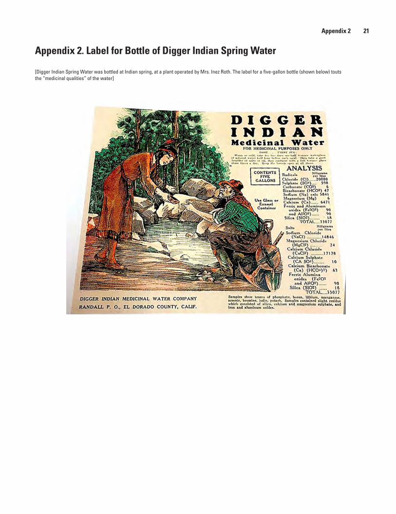
Appendix 2 21
Appendix 2. Label for Bottle of Digger Indian Spring Water
[Digger Indian Spring Water was bottled at Indian spring, at a plant operated by Mrs. Inez Roth. The label for a five-gallon bottle (shown below) touts the “medicinal qualities” of the water]

Menlo Park and Lafayette Publishing Service CentersManuscript approved for publication May 26, 2017Edited by Taryn A. LindquistLayout and design by James E. Banton

Moore and others—
The Saltiest Springs in the Sierra Nevada, California—
Scientific Investigations Report 2017–5053
ISSN 2328-0328 (online)https://doi.org/10.3133/sir20175053