the scenario of brazilian amazon transportation infrastructure in the natural hazards context
TRANSCRIPT
American Journal of Engineering Research (AJER) 2015 American Journal of Engineering Research (AJER)
e-ISSN: 2320-0847 p-ISSN : 2320-0936
Volume-4, Issue-5, pp-216-232
www.ajer.org Research Paper Open Access
w w w . a j e r . o r g
Page 216
The Scenario of Brazilian Amazon Transportation Infrastructure
in the Natural Hazards Context
Rafael Almeida Flores, Claudio Fabian Szlafsztein. 1 Civil Engineer, M.Sc. in Development Planning.
1 Ph.D. in Geography. Federal University of Pará Researcher and Professor.
Abstract: The development of a region is related, in part, to its ability to establish relations with other regions
and the efficiency with which it operates internally and streamlines their intra relations. The study of the
impacts in the availability of transport infrastructure in regional development interests by the influence it has on
the location decisions of investment. The network of transport infrastructure in the Brazilian Amazon region is
susceptible to interruptions in its functioning by pressures arising from the interaction of coupled human and
natural systems, impacting regional development mainly by isolating regions raising concerns about human
security of local residents and the economic development to the extent that regional production does not
circulates temporarily, eliminating one of the economy dynamics main stages. The susceptibility indicators of
transport infrastructure system in the Amazon are unclear and this study presents disruptions causes, frequency,
potential risks and impacts in this system functioning.
Key words: Disasters; Roadways; Transportation; Infrastructure; Development.
I. INTRODUCTION For many years, the Amazon region of Brazil has been considered immune to the hazard of natural disasters.
However, in recent years, extreme natural events, increasing their magnitudes and frequencies, has manifested
itself in urban and rural areas in this region. Consequently, this territory has been exposed to the impacts of
some technological and natural hazards, most being associated with droughts, floods, fires and erosion of soils,
rivers and coastal areas (SZLAFSZTEIN, 2012). The interaction between the natural environment behavior in
and the facilities built interests in the context of environmental discussions of changes in climate and
sustainable development planning. This way of thinking the future considers the supply chains improvement,
transportation logistics, the exploitation of natural resources and other factors and should be the agenda of
research aimed at understanding and promote regional development. Theme researchers have focused their
attention on the relationship between natural disasters and vulnerability to these populations that have not
focusing so much on the role played by the development components, such as the infrastructure of the region.
This approach focuses on infrastructure development study as promoter but also as agent impacted by natural
phenomena. This is done not only through the answers that are given by the company to mitigate the effects of
damaging effects, but mainly by highlighting the increased susceptibility of infrastructure disaster.
This study describes how the infrastructures are affected by natural hazards in the Amazon, causing a delay in
regional development by presenting non-functional periods due to disasters. The development of a region is
related, in part, to their ability and efficiency to establish relations with other regions, as well as its efficiency to
operate their internal relations. This depends on the existing systems to transport services, information, people
and goods (eg. land transport, water and air). Without this infrastructure there is no way to get the labor force
to move to the place of production, it cannot carry the raw material and it is not possible for the potential
consumer market has access to the product. Dependent regions of only one form of transport leaving its
population susceptible to isolation. This way you can think relations between transport infrastructure, economic
growth and regional disparities as development components. Araújo (2006) indicates that the issue of transport
infrastructure is a structural problem to the Brazilian development, in that it does not provide adequate and
balanced conditions between regions.
Infrastructure facilities are necessary for the functioning of a society, grouping a set of interconnected
structural elements that support the entire development framework (SULLIVAN, 2003). These are roads,

American Journal of Engineering Research (AJER) 2015
w w w . a j e r . o r g
Page 217
bridges, water supply, sewage systems, distribution networks for energy and telecommunications, which are the
physical components of networks that provide goods and services essential to make possible, sustainable and
better conditions lifetime (FULMER, 2009). These elements fulfill a key role in social, economic and
institutional of a society. Socially, the infrastructure promotes adequate housing, work, health, education,
leisure and security. Economically, the infrastructure based on the development of productive activities, i.e. the
production and marketing of goods and services. And institutionally, provides the means to develop the political
and administrative activities (ZMITROWICZ e ANGELIS NETO, 1997). Some infrastructure (eg.
communication systems, water supply, transport) are classified as lifelines for providing essential conditions of
movement of persons, goods, services and information (PLATT, 1991), being systems and facilities that are also
important elements of response and emergency recovery after natural disasters (MCEER, 2013) therefore, are
vital infrastructure lines to the development and growth of a company, having, therefore, a growing concern to
understand their vulnerability to damage and breakages during disasters (DALZIELL e NICHOLSON, 2001).
In the Brazilian Amazon natural disasters negatively impact a region whose development is already shows
problems, with particular emphasis on economic and environmental activities in the most vulnerable population
(eg. poverty in urban areas and in rural communities). The situation tends to get worse considering the forecast
usage scenarios more intense and extensive forest and increased occupation in the cities, as well as the
intensification of climate change in the Amazon. In this regard, a major challenge is to develop and implement
risk management policies, strategies and measures that may suit regional peculiarities (SZLAFSZTEIN, 2012).
Disaster is understood as any interruption in the natural cycle of development of any person, population,
society, economic activity and etc. Therefore, it is any event that, somehow, has this feature to stop the
development. The United Nations (UN) defines natural disasters as the consequences of impacts, damages from
extreme or intense natural phenomena on a socioeconomic system, which exceed the capacity of the system
affected to eliminate or live with the impact (UN-ISDR, 2009).
The understanding of the relationship between infrastructure and natural disasters to cause impacts to
development is related to the concept of vulnerability, which can be analyzed from the relationship between
exposure to a particular risk (susceptibility) and the level of adaptation to a defined area, activity, population or
infrastructure features at a specific time (IPCC, 2007; PENTEGUEL, 2010). Susceptibility is defined as the set
of characteristics and circumstances, to which the infrastructure is submitted, which make this is susceptible to
the damaging effects of a hazard, regardless of exposure (UN-ISDR, 2009). The negative impacts - such as
interruption of roads, telecommunications and shortages - are perceived by users (eg drivers, passengers and
goods transported owners.) The service provided by the infrastructure dedicated to the effective and efficient
transport of goods, raw materials, people and information is vulnerable in this context. This means that if a
road by which carries a commodity becomes less efficient due to heavy traffic, the erosions on the track that
cause narrowing of the road or temporary interruption of the road with or without alternative routes, the impact
is perceived in daily activities of the population, thus an impact on regional development. The existing hierarchy
We highlight the impacts exemplified here, since not only transport is replaced by a higher cost for having to
stay longer on the highway (ex. Perishable loads and cooling dependent), but also activities in one of the
locations depending on the highway (eg. gas stations, or raw material for the final consumer of the product).
Thus, this article aims to describe the scenario in which the Amazonian transportation infrastructure is in the
Amazon in the context of natural disasters, presenting a systematic, organized and distributed in space disaster
occurrence data on federal highways in northern Brazil and discussing how the relationship between the
operation of the infrastructure and natural disasters acts simultaneously as impactful agent and as a driver of
regional development. A spatial database outages transport infrastructure in the Brazilian Amazon as a result
of natural disasters appears. It discusses the existence of patterns in the occurrence of disasters that correspond
to the hazards that originate, considering the location in the study area.
II. MATERIALS AND METHODS
2.1 Disasters Spatial Distribution
A survey of documents from the regional journals in the period between 2011 and 2014 has been made, which
included civil defense agencies, fire departments and the National Department of Transport Infrastructure
(DNIT). These sources are news portals G1 Amazonas, Pará G1, G1 Maranhão, D24AM News, Estradas, A
Critica, A Tarde, O Impacto, the Diário do Pará newspaper, Folha da Boa Vista, Jornal do Brazil, Correio do
Estado and reports made by the Brazilian Army Engineering and Construction Battalion (BEC) and the DNIT.
Search sites on the Internet were the first information access channel, which was later supplemented by the
reports and exchange of e-mails of DNIT representatives of the states of Pará and Amazonas. This information,
cataloged in spreadsheets organized by event date, the interruption location (city, state, coordinated
geographical), the road interruption cause were the source of information and the database integrating a
geographic information system. The sequence "disaster, impacts and response" was used to read the news

American Journal of Engineering Research (AJER) 2015
w w w . a j e r . o r g
Page 218
report that these steps that have developed in the course of perception of the disaster. All data sources report
that occurred as follows: a. Disaster (heavy rain, river flood); b. Primary impact (highway interruption); c.
Secondary impacts (floor drains or rupture, isolation, row of stationary vehicles) and; d. Response type
(alternative methods of transportation by water, deviations guided by the Federal Highway Police - PRF). With
Google Maps the reference point informed in the event description was located. The intersection with bodies of
water or other roads served to the point location, allowing its coordinated be saved. Intersections of rivers or
other perpendicular axes to highways served as references (Figure 1). In cases without this feature we used the
"Routes" tool to locate the point by measuring its distance to the beginning of the highway km count.
Figure 1. Geographic coordinates obtained for preparation of maps
The maps were developed with geographic information systems (GIS) by inserting a layer of points representing
the coordinates written text file (.txt) with three columns: code, latitude and longitude (Figure 2). Thus it was
possible to plot on a file layer the points, as well as provide them with features icons that distinguish them from
each other. The event classification by type of interruption is done through five files named "highways cuts" and
characterized by the type of originating event: erosion (ER), pipe rupture (RT), break bridges (RP), flood (IN)
and Muds (AT). Each one of these files makes up a group of pictures corresponding to a layer on the map. Thus,
each event type may be represented by an icon type, differentiating map the cause of the interruption at each
point. Each text file contains a number of coordinates for the type of event, numbered according to the totality of
cases. This file type organized in tables the coordinates to be inserted in the software and generate the maps.
Figure 2. Geographical coordinates numbered and sorted for map-making.
2.2Characterization of the Study Area
The northern Brazil is composed by the states of Acre, Amapá, Amazonas, Pará, Rondônia, Roraima and
Tocantins, which contain watersheds of major proportions and with great potential for water transportation and
presents a low density road network. The Legal Amazon encompasses the states mentioned above plus the states
of Maranhão and Mato Grosso. In addition, the North Region has 16.3 million inhabitants (IBGE, 2013), which
represents 8% of the brazilian population. Depending on the historical and territorial formation of the Amazon,
this population lives in cities subjected to isolation with broken roads, usually concentrating near rivers and
other bodies of water, including populations of urban centers and rural communities, subject to the impacts of
disasters. The Amazon forest is classified in three types: the land forest, the flooded forest (always flooded) and
lowland (sporadic flooding) (ATLAS NATIONAL GEOGRAPHIC, 2008). It is a heterogeneous territory divided
into six states and 310 municipalities (in Brazil), covering 3,575,951 km² and representing approximately 40%
of the national territory. Despite the intense exploitation of natural resources, 62% of this area is original forest
cover and about 20% is already impacted. In addition to the forests and their biodiversity, the region has a huge
amount of mineral resources and has become, since the 1980s the latest agricultural frontier of the country.
(SZLAFSZTEIN, 2012).
American Journal of Engineering Research (AJER) 2015
w w w . a j e r . o r g
Page 219
As hydro geological system, the Amazon basin stands out for its influence on the global climate and carbon
cycle (RICHEY et al., 2002 MELACK et al., 2004). In addition to the human pressures, this system is under risk
because of recent floods and extreme droughts (CHEN et al, 2010 TOMASELLA et al, 2010; MARENGO et al.,
2008), windstorms, earthquakes, soil erosion of river banks and coastal areas as well as natural or arson
(SZLAFSZTEIN, 2003; EGER and AQUINO, 2006; MAIA et al, 2008) that major impacts on the Amazon
population dependent on rivers for transportation, energy, food (PAIVA, 2013). Flood plains are formed by
sediments just above the water level periodically. The Amazonian plateau has maximum altitude of 200 m and is
formed by sediments. It is heavily compartmentalized by streams of drainage network and rivers, with steep
topography. The crystalline shells are located north and south of the sedimentary basin, very flat with this, so
that the contact is only marked by the area of the waterfalls of the tributaries of the Amazon River, with this
area altitude above 200 m (ENVIRONMENT BRAZIL, 2014). Presents extensive wetlands flooded (HESS et al.,
2009) with a complex water flow mechanism (ALSDORF et al., 2007), and heavy precipitation with high spatial
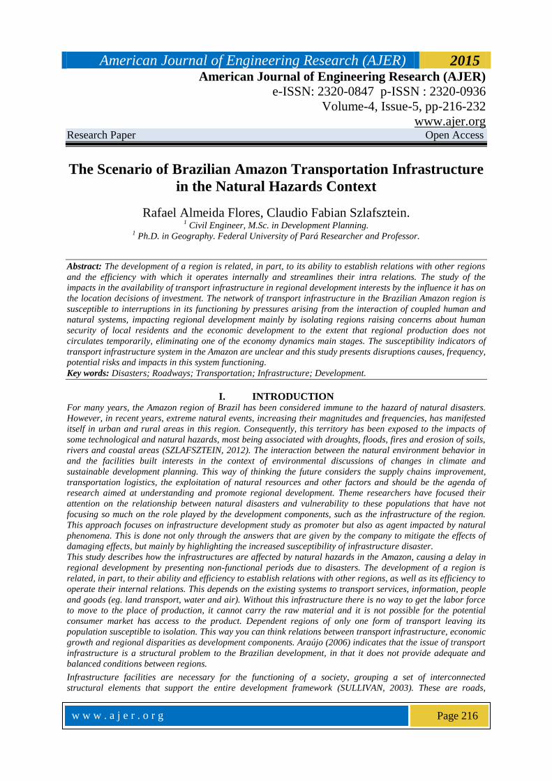
and temporal variability, with hydro climatic regime contrasting in their different regions (ESPINOZA et al.,
2009) (Figure 4).
Figure 3. Variability of rainy season in the Amazon.
Source: ESPINOZA, 2014.
2.3 Theoretical Framework
Risk is the interaction product between human decisions and the ecosystem in which people are inserted. The
risk assessment involves the analysis of the likelihood of occurrence of a disaster resulting from the destruction
or disruption of the highway activities. This concept involves two main components: a natural hazard and the
preparation of the population. The first corresponds to the probability of a natural phenomenon causing
positive or negative consequences in a component of the company, corresponding to the second component, has
a degree of preparation to deal with that event. The higher this preparation, the lower the disaster risk. Hazards
are those elements present in the physical environment that are harmful to man and are caused by forces
beyond him (Burton, 1978), and, more specifically, all atmospheric, hydrological, geological phenomena, the
location, severity and frequency, have the potential to affect humans, their structures or their unfavorably
activities (OAS, 2014). The consequences of highways by natural hazards interruptions includes the cost of any
repair work (eg. Bridge repairs, reconstruction of road sections) as well as the economic cost of the trips were
discontinued, the first being absorbed by the administrator and the second by users. The costs of the users
depend on the duration of the interruption, the largest distances in alternative routes or losses derived from the
option to postpone or give up the trip. The probability of a certain magnitude disaster occur in any year is
uncertain. For some specific disaster there is a low probability of having an event of sufficient magnitude to
disrupt the pathway, thus being an estimate of the probability of closing limited historical data. In this way, add
up to subjective aspects previously mentioned the uncertainty of trying to predict the hazards (DALZIELL and
NICHOLSON, 2001).
According Szlafsztein (2012), disaster is any interruption in the natural cycle of development of the activities of
any person, population, society or economic activity, among other components of a society. The relationship
between disaster and disaster risk, therefore, is given by the way in which society deals with the probability of
being affected by a hazard, since the risk may be lower if the preparation of the population to receive that
hazard is greater, being the opposite also applies. It is considered an event such as disaster when at least one of
the following conditions are identified: 10 or more people have died as a result of the event; 100 or more people
have been affected; Has been declared the emergency and public authorities; Has been requested international
assistance (CRED, 2009). In Amazon there are hazards related hydro climatic phenomena (eg. floods and
American Journal of Engineering Research (AJER) 2015
w w w . a j e r . o r g
Page 220
droughts), earthquakes, winds, soil erosion (land division, margins of rivers and coastal areas). Naturally
occurring disasters in the region are becoming more frequent and intense, droughts and floods highlighting
(MARENGO et al, 2011; SENA et al, 2012; TOMASELLA et al, 2012.).
2.4 Scenario of research on evaluation of disasters and infrastructure
The lifeline engineering aims to develop mechanisms that act on two main fronts to mitigate the effects of
hazards to roads: recovery measures and emergency surgery reconstruction with quick access to the event,
which includes risk mapping throughout the extension of roads, and the development of alternative routes that
operate based on the classification of the type of vehicle is running and that they consider the possibility that
these alternatives are also affected by the disaster in addition to driving conditions, fuel availability and other
services basic equivalent to those available on the main road, managing to reduce the dwell time and the
frequency with which this occurs. The study of natural hazards and risks is more developed in places where
there are hazards of magnitude more easily perceived by the population, by abruptly these hazards. The
relationship between the components agents involved in a management program (technical tools, administrative
and social) can be analyzed with a simplified organizational framework: the PSIR cycle (Pressure, State,
Impact and Response). This methodology evaluates the steps and components of the event. When climatic and
anthropogenic pressures cause partial or total imbalance in the environment the first effects are changes in the
state of soil, water, habitat and cover and land use. This imbalance results in impacts such as pollution,
degradation, change and migration, affecting the natural processes, the use and protection of resources and
socio-economic activities. Vulnerability and impacts assessments also provide a starting point for the
determination of effective corrective actions to mitigate the impacts and restore the original condition as soon
as possible through support policies spontaneous or planned responsive character. This means that both the
total or partial mitigation of the causes of imbalance or adapt to new conditions are necessary. Adaptive
responses aimed mainly reduce system vulnerability, however, it can also cause changes in pressure
(SZLAFSZTEIN, 2005). These relationships are checked when the pressures generate impacts that are
perceived by society. This perception may be, in addition to physical damage, through financial losses.
According Dalziell and Nicholson (2001), the economic costs of the road closure depend on the possibility of
using alternative routes while it is closed, and the reason the closing occurs. Due to the correlation between the
road conditions through the network from a natural event, such as a flood, the effects of which will be spread
over a large geographical area. You must also interpret the vulnerability of alternative routes. The
interpretation of this simultaneity in the Amazon region may consider flood areas within basins with a
considerable area and enable the interrupt snippets that would be alternatives.
III. RESULTS AND DISCUSSIONS 3.1Disruptions Description
Items 4.1.1 to 4.1.3 occurred by pavement layers erosion. 4.1.4 to 4.1.12 disruptions is given by the rupture of
the culvert pipe system greide. The events described in items 4.1.13 to 4.1.16 occurred by breaking bridges or
part of them wear. 5.1.17 4.1.23 occurrences are caused by the flooding of the highway due to full rivers and
finally 4.1.24 to 4.1.27 disruptions were due to the inability traffic road conditions due to accumulation of
sludge called here as Muds.
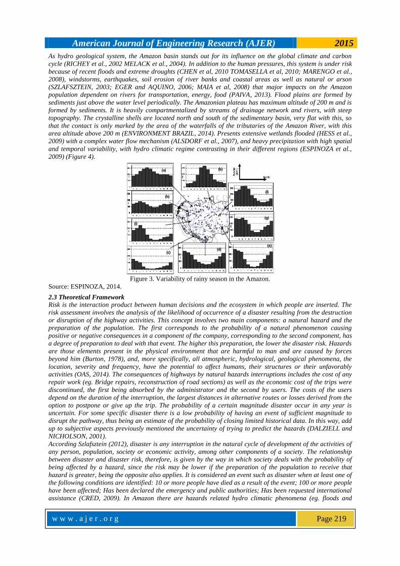
4.1.1 In the BR-174 highway an erosion of the
component layers of the road damaged the structure,
causing the disruption of the upper layer of the floor.
This led to traffic disruption. The incident occurred in
the Presidente Figueiredo county (AM), to 117 km
from the capital of that state, Manaus (Figure 4). The
region was isolated for access of land vehicles of any
kind until the work was performed recovery (G1
AMAZONAS, 2014).
Figure 4. BR-174. Disruption by erosion. 117 km from
Manaus. Source: G1 Amazonas, 2014.
American Journal of Engineering Research (AJER) 2015
w w w . a j e r . o r g
Page 221
4.1.2 The BR-174 highway, in the stretch between the
cities of Manaus (AM) and Boa Vista (RR), was partially
banned by the erosion that only allowed the traffic light
vehicles and pedestrians. This occurred in 58 km in the
state of Amazonas, and the response was through the
installation, by the DNIT, a metal bridge to the release of
the traffic of all types of vehicles as the work of the
infrastructure recovery was not started (DNIT, 2014).
4.1.3 The BR-364 highway was banned for repairs
motivated by an erosion that damaged the structure of
the pavement. The traffic was allowed only in middle
lane at km 232 and for small vehicles during
maintenance (DNIT, 2014). After the action of DNIT
to recover the road structure the truck and bus traffic
has resumed normal conditions, thus reestablishing
the freight service and people.
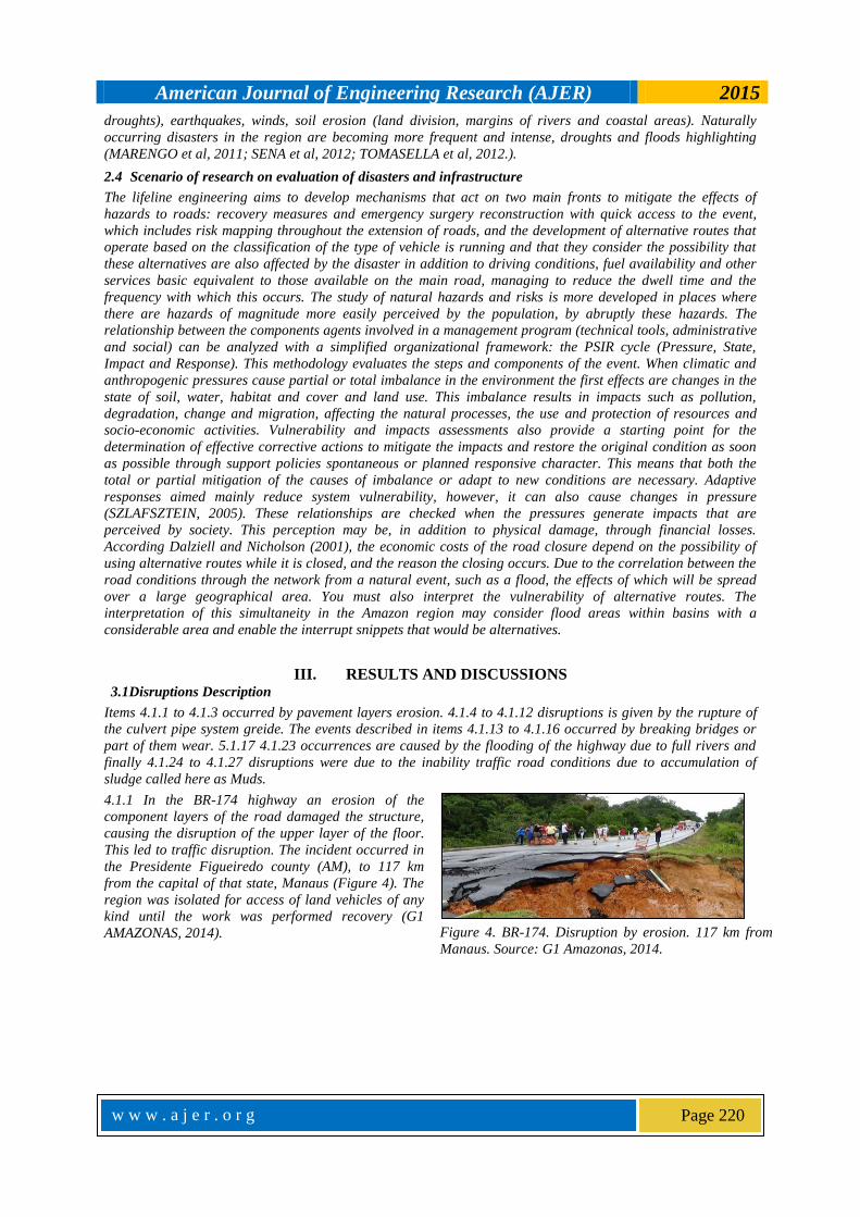
4.1.4 The BR-174 highway was banned in both directions because a concrete pipe gallery broke and tore a hole in
the track, at km 83, near Presidente Figueiredo (AM) (Figure 5). This left many isolated communities. In response
to PRF guided the road from Manaus and Boa Vista not to release for circulation to buses until the situation were
normalized. In addition, the fire department helped transport people into commodities with a boat. Restoration
work began on the same day (D24AM, 2011).
Figure 5. Disrupt in BR-174 by pipe rupture gallery. Source: D24AM, 2011.
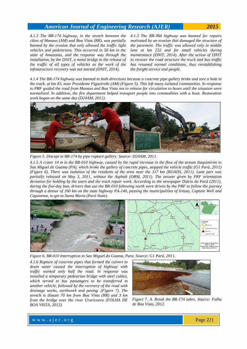
4.1.5 A crater 14 m in the BR-010 highway, caused by the rapid increase in the flow of the stream Itaquimirim in
Sao Miguel do Guama (PA), which broke the gallery of concrete pipes, stopped the vehicle traffic (G1 Pará, 2011)
(Figure 6). There was isolation of the residents of the area near the 317 km (ROADS, 2011). Lane part was
partially released on May 3, 2011, without the Asphalt (ORM, 2011). The answer given by PRF orientation
deviation for holding by the users and the track repair work. According to the newspaper Diário do Pará (2011),
during the five-day ban, drivers that use the BR-010 following north were driven by the PRF to follow the journey
through a detour of 160 km on the state highway PA-140, passing the municipalities of Irituia, Captain Well and
Capanema, to get to Santa Maria (Pará State).
Figure 6. BR-010 Interruption in Sao Miguel do Guama, Para. Source: G1 Pará, 2011.
4.1.6 Rupture of concrete pipes that formed the culvert to
drain water caused the interruption of highway with
traffic worked only half the road. In response was
installed a temporary pedestrian bridge with steel cables,
which served to bus passengers to be transferred to
another vehicle, followed by the recovery of the road with
drainage works, earthwork and paving. (Figure 7). The
stretch is distant 70 km from Boa Vista (RR) and 3 km
from the bridge over the river Uraricoera (FOLHA DE
BOA VISTA, 2012).
Figure 7. A. Break the BR-174 tubes. Source: Folha
de Boa Vista, 2012.
American Journal of Engineering Research (AJER) 2015
w w w . a j e r . o r g
Page 222
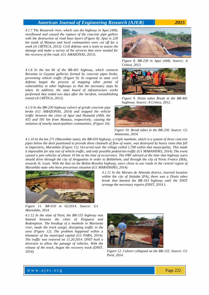
4.1.7 The Roosevelt river, which cuts the highway in Apuí (AM),
overflowed and caused the rupture of the concrete pipe gallery
with the destruction of road base layers (Figure 8). Apuí is 220
km south of Manaus and local communities were cut off for a
week (A CRÍTICA, 2013). Civil defense sent a team to assess the
damage and make a survey of the services that were needed for
the recovery of the road. (G1 AMAZONAS, 2013).
Figure 8. BR-230 in Apuí (AM). Source: A
Critica, 2013.
4.1.8 In the km 66 of the BR-401 highway, which connects
Roraima to Guyana galleries formed by concrete pipes broke,
preventing vehicle traffic (Figure 9). In response to state civil
defense began the process of mapping other points of
vulnerability in other highways so that the necessary steps be
taken. In addition, the state board of infrastructure works
performed that ended two days after the incident, reestablishing
transit (A CRÍTICA, 2012).
Figure 9. Drain tubes Break in the BR-401
hughway. Source: A Critica, 2012.
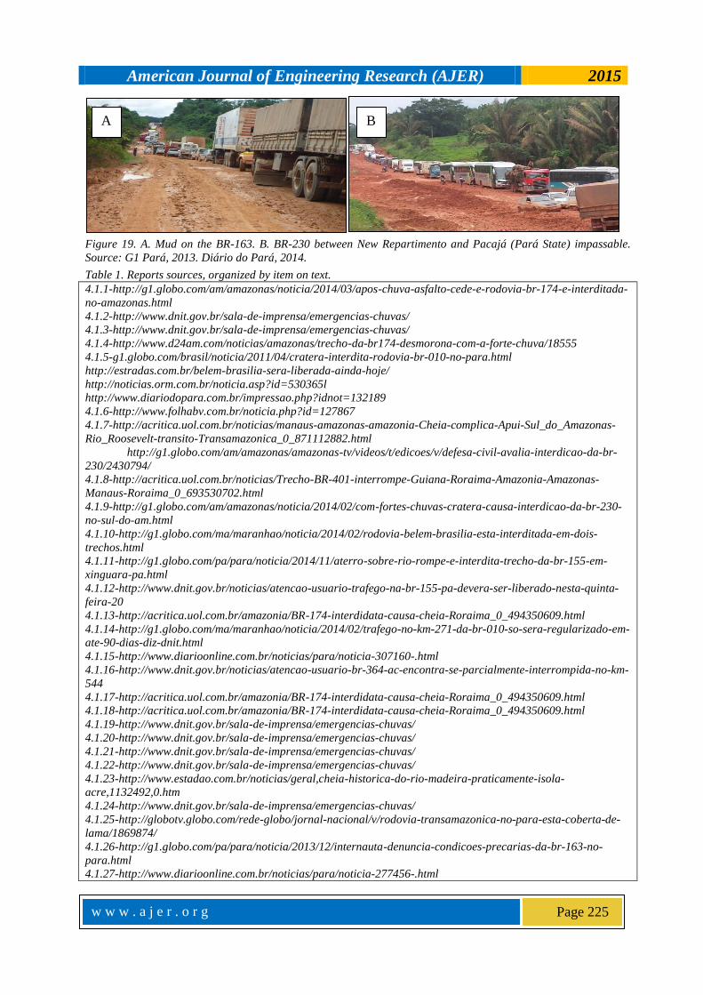
4.1.9 In the BR-230 highway culvert of greide concrete pipe
broke (G1 AMAZONAS, 2014) and stopped the vehicle
traffic between the cities of Apuí and Humaitá (AM), the
455 and 591 km from Manaus, respectively, causing the
isolation of nearby municipalities communities. (Figure 10).
Figure 10. Break tubes in the BR-230. Source: G1
Amazonas, 2014.
4.1.10 In the km 271 (Maranhão state), the BR-010 highway, a triple manhole, which is a system of three concrete
pipes below the deck positioned to provide three channels of flow of water, was destroyed by heavy rains that fell
in Imperatriz, Maranhão (Figure 11). Occurred near the village called 1,700 within that municipality. This made
it impossible for any size of vehicle traffic, and only possible pedestrian traffic (G1 MARANHÃO, 2014). The event
caused a jam vehicles of almost 10 km at the time of occurrence. The PRF advised at the time that highway users
should drive through the city of Araguatins in order to Bethlehem, and through the city of Porto Franco (MA),
towards St. Louis. With the ban on the Belém-Brasília highway, users chose to use roads in the central region of
Maranhão state who have precarious situation (G1 MARANHÃO, 2014).
Figure 11. BR-010 in 02/2014. Source: G1
Maranhão, 2014.
4.1.11 In the Moraes de Almeida district, inserted location
within the city of Itaituba (PA), there was a Drain tubes
break that banned the BR-163 highway until the DNIT
arrange the necessary repairs (DNIT, 2014 ).
4.1.12 In the state of Pará, the BR-155 highway was
banned between the cities of Xinguara and
Redemption. The breakup of a manhole in Marinette
river, made the track assign, disrupting traffic in the
area (Figure 12). The problem happened within a
kilometer of the municipal capital (G1 PARA, 2014).
The traffic was restored on 11.20.2014. DNIT built a
diversion to allow the passage of vehicles. With the
release of the track, began the recovery track (DNIT,
2014).
Figure 12. Culvert collapsed on the BR-155. Source: G1
Pará, 2014.
American Journal of Engineering Research (AJER) 2015
w w w . a j e r . o r g
Page 223
4.1.13 interruption occurred between Normandy municipalities (RR) and Paracaima (RR) for damage caused by
the rise in Igarapé Javari level to the bridge structure on this body of water (A CRÍTICA, 2011).
4.1.14 In Imperatriz (MA), traffic on the BR-010
had been closed because it was committed to its
structure (G1 Maranhão, 2014). Rainfall in the
region also caused an increase in the volume of
water from the stream Pond Surrounded. The
strong current of Rio Grande Bar undertaken to
bridge the connection structure with the ground-
road (Figure 13).
Figure 13. A. damaged bridge on US-010. Source: G1
Maranhão, 2014.
4.1.15 Part of the bridge over the river Arataú, the BR-230 was shot down by the water Arataú river after a heavy
rain that fell in the southwestern region of Pará (Figure 14). This bridge was built by the Brazilian Army three
months before this event. The DNIT infrastructure analyst, Marcelo Paiva said the bridge reconstruction would
begin only when the water level back to normal level. While this did not happen the transport service in the region
was paralyzed (DIÁRIO DO PARÁ, 2014).
Figure 14. A. Rio Arataú damages bridge and passengers expect the transport service re-establishment. Source:
Diário do Pará, 2014.
4.1.16 Due to the flooding river Tarauacá in Acre, BR-364
highway was partially interrupted because of damage at
threshold (bridge connecting structure - ground) of the
bridge in the municipality of Tarauacá (Figure 15). There
was part of disruption of landfills that support the
transition slab. The Regional Superintendent of DNIT
assessed the damage to the head of the bridge and carried
out works for stability and security to users (DNIT, 2014).
Figure 15. Bridge over the River Tarauacá (AC) with
damage to its structure. Source: DNIT, 2014.
4.1.17 Among the City of Cornwall and the South region of the
state of Roraima, vehicle traffic was stopped due to the full the
White River that flooded parts of the BR-432 highway. (Figure
16A). The answer was through preventive traffic disruption by
the PRF and the recovery depended on the water level of
behavior, that is, the highway was used again when the water
level was lower (A CRÍTICA, 2011).
4.1.18 In the region of Caracaraí in Roraima,
the BR-174 highway was flooded due to the full
Rio Branco (Figure 16B), which reached 10.55
meters above its normal level (A CRÍTICA,
2011). The traffic on that road was interrupted
paralyzing transport services of persons and
goods in the region.
Figure 16. A. BR-432 flooded with traffic stopped. B. BR-174 with traffic stopped in the city of Caracaraí, RR.
Source: A Crítica, 2011.
A B

American Journal of Engineering Research (AJER) 2015
w w w . a j e r . o r g
Page 224
4.1.19 Full of Wood River and its tributaries
caused the flooding of the BR-319 highway in the
state of Rondônia such that the 18 km stretch of
that state, towards the town of Humaitá (AM)
was impassable (DNIT, 2014) until the water
level lowered.
4.1.20 At another point, full of the Madeira River and its
tributaries caused the flooding of the BR-319 highway at km
stretch of 20, near the city of Humaitá, in Amazonas state,
which was forbidden (DNIT, 2014). The section, which is
distant two kilometers of occurrence in the previous items was
no traffic until the water level decrease.
4.1.21 The BR-364 highway, due to the full the Madeira River, flooded resulted in 871 km, with the traffic of all
types of vehicles unable (DNIT, 2014). The vehicles transit was released only after the water level dropped.
4.1.22 The BR-364 highway, due to the full the Madeira River, flooded resulted in 871 km, with the traffic of all
types of vehicles unable (DNIT, 2014). This is the same flooded stretch mentioned in the previous section, with the
two-week difference.
4.1.23 In a joint decision between DNIT and PRF
vehicle traffic on the BR-364 highway had been
closed for security between the states of Acre and
Rondonia due to heavy rains and flood in which
was the Rio Madeira (ESTADÃO, 2014). The water
level of the river Madeira, which lies in the region
between the two states, was about 18 m above the
normal level.
Figure 17. BR-364 highway flooded near Porto Velho
(Rondonia State). Source: Correio do Estado, 2014.
4.1.24 On February 19, 2014, the Brazilian
Army, in keeping with DNIT's request, has
mobilized to minimize the problem, given that
the contractors responsible for that section
were not keeping the trafficability the
highway and maintenance shuttle service
(Figure 18A) (DNIT, 2014).
4.1.25 The Trans-Amazon highway Muds that had made it
impossible to traffic in southwestern Pará (Figure 15B). The
stretch between the city of Altamira and the area of construction
of the hydroelectric plant of Belo Monte is the exact location
occurred (GLOBO, 2012). The passage considered without traffic
conditions has a length of 7 km and for its location, prevents
traffic construction consortium machines hydroelectric plant of
Belo Monte.
Figure 18. A. Mud in Trairão (PA), the Caracol location. B. BR-230 in Altamira-PA interrupted. Source: Brazilian
Army, 2014. Globo, 2012.
4.1.26 The BR-163 highway, near Trairão (Pará State),
was no vehicle traffic conditions due to mire (Figure 16A).
A row of stationary vehicles graduated paralyzing any
transportation service of persons or goods (G1 PARÁ,
2013). The service recovery was due to the change of time
and decreased rainfall. There was no interference state
for the recovery of the infrastructure.
4.1.27 A quagmire caused the interruption of traffic
(Figure 16B) in the stretch between the cities of Novo
Repartimento and Pacajá (Pará State) (DIÁRIO DO
PARÁ, 2014). The recovery of the change depended
on the decrease of the precipitation procedure. There
was no state intervention related to the recovery of
infrastructure.
A B
American Journal of Engineering Research (AJER) 2015
w w w . a j e r . o r g
Page 225
Figure 19. A. Mud on the BR-163. B. BR-230 between New Repartimento and Pacajá (Pará State) impassable.
Source: G1 Pará, 2013. Diário do Pará, 2014.
Table 1. Reports sources, organized by item on text.
4.1.1-http://g1.globo.com/am/amazonas/noticia/2014/03/apos-chuva-asfalto-cede-e-rodovia-br-174-e-interditada-
no-amazonas.html
4.1.2-http://www.dnit.gov.br/sala-de-imprensa/emergencias-chuvas/
4.1.3-http://www.dnit.gov.br/sala-de-imprensa/emergencias-chuvas/
4.1.4-http://www.d24am.com/noticias/amazonas/trecho-da-br174-desmorona-com-a-forte-chuva/18555
4.1.5-g1.globo.com/brasil/noticia/2011/04/cratera-interdita-rodovia-br-010-no-para.html
http://estradas.com.br/belem-brasilia-sera-liberada-ainda-hoje/
http://noticias.orm.com.br/noticia.asp?id=530365l
http://www.diariodopara.com.br/impressao.php?idnot=132189
4.1.6-http://www.folhabv.com.br/noticia.php?id=127867
4.1.7-http://acritica.uol.com.br/noticias/manaus-amazonas-amazonia-Cheia-complica-Apui-Sul_do_Amazonas-
Rio_Roosevelt-transito-Transamazonica_0_871112882.html
http://g1.globo.com/am/amazonas/amazonas-tv/videos/t/edicoes/v/defesa-civil-avalia-interdicao-da-br-
230/2430794/
4.1.8-http://acritica.uol.com.br/noticias/Trecho-BR-401-interrompe-Guiana-Roraima-Amazonia-Amazonas-
Manaus-Roraima_0_693530702.html
4.1.9-http://g1.globo.com/am/amazonas/noticia/2014/02/com-fortes-chuvas-cratera-causa-interdicao-da-br-230-
no-sul-do-am.html
4.1.10-http://g1.globo.com/ma/maranhao/noticia/2014/02/rodovia-belem-brasilia-esta-interditada-em-dois-
trechos.html
4.1.11-http://g1.globo.com/pa/para/noticia/2014/11/aterro-sobre-rio-rompe-e-interdita-trecho-da-br-155-em-
xinguara-pa.html
4.1.12-http://www.dnit.gov.br/noticias/atencao-usuario-trafego-na-br-155-pa-devera-ser-liberado-nesta-quinta-
feira-20
4.1.13-http://acritica.uol.com.br/amazonia/BR-174-interdidata-causa-cheia-Roraima_0_494350609.html
4.1.14-http://g1.globo.com/ma/maranhao/noticia/2014/02/trafego-no-km-271-da-br-010-so-sera-regularizado-em-
ate-90-dias-diz-dnit.html
4.1.15-http://www.diarioonline.com.br/noticias/para/noticia-307160-.html
4.1.16-http://www.dnit.gov.br/noticias/atencao-usuario-br-364-ac-encontra-se-parcialmente-interrompida-no-km-
544
4.1.17-http://acritica.uol.com.br/amazonia/BR-174-interdidata-causa-cheia-Roraima_0_494350609.html
4.1.18-http://acritica.uol.com.br/amazonia/BR-174-interdidata-causa-cheia-Roraima_0_494350609.html
4.1.19-http://www.dnit.gov.br/sala-de-imprensa/emergencias-chuvas/
4.1.20-http://www.dnit.gov.br/sala-de-imprensa/emergencias-chuvas/
4.1.21-http://www.dnit.gov.br/sala-de-imprensa/emergencias-chuvas/
4.1.22-http://www.dnit.gov.br/sala-de-imprensa/emergencias-chuvas/
4.1.23-http://www.estadao.com.br/noticias/geral,cheia-historica-do-rio-madeira-praticamente-isola-
acre,1132492,0.htm
4.1.24-http://www.dnit.gov.br/sala-de-imprensa/emergencias-chuvas/
4.1.25-http://globotv.globo.com/rede-globo/jornal-nacional/v/rodovia-transamazonica-no-para-esta-coberta-de-
lama/1869874/
4.1.26-http://g1.globo.com/pa/para/noticia/2013/12/internauta-denuncia-condicoes-precarias-da-br-163-no-
para.html
4.1.27-http://www.diarioonline.com.br/noticias/para/noticia-277456-.html
A B
American Journal of Engineering Research (AJER) 2015
w w w . a j e r . o r g
Page 226
The occurrences are synthesized of highways interrupted between 2011 and 2014 in the study area (Table 1)
according to the cause of each and accompanied by relevant data columns for the record. The location map that
complements this information was developed with GIS software, from the location information of the news
converted to geographical coordinates, based on technical DNIT manual about naming guidelines,
classification and miles count on federal highways. This information was organized through interrupt
spreadsheet construction ordering classifies the items according to the cause of the disaster impact. The column
"item" refers to the order in which the records have been presented in the text, while "BR" refers to federal
highway that was interrupted and discriminates each line in the reference code of each road. The "km" is
complemented by the column "coordinated" and refers to the kilometers count that is used by the DNIT to place
the road cut location. The column named "reference" reports the site employed by news source to describe the
occurrence. In "UF" reports to state federative unit, while columns "Reason" and "Data" report the impact of
the first order that triggers the interruption of the highway and date on which the incident occurred,
respectively.
Table 1. Interruptions in federal highways in the Brazilian Amazon between 2011 and 2014.
Ite
m
B
R km
Referen
ce
Sta
te Date
Ty
pe
Coordin
ate
Ite
m
B
R km
Referenc
e
Sta
te Date
Ty
pe
Coordin
ate
La
t
Lon
g
La
t
Lon
g
4.1.
1
17
4
11
8
Preside
nte
Figueire
do
A
M
2/3/1
4
Ero
sio
n
-
1.9
6
-
60.
03
4.1.
13
43
3 99
Normand
ia -
Paracaim
a RA
6/6/1
1
Bre
ak B
rid
ge
3.9
3
-
60.
35
4.1.
2
17
4 58 Manaus A
M
5/3/1
4
-
2.4
7
-
60.
03
4.1.
14
01
0
13
88
Imperatri
z M
A
17/2/
14
-
5.3
8
-
47.
47
4.1.
3
36
4
23
2
Porto
Velho RO
24/3/
14
-
9.6
5
-
65.
51
4.1.
15
23
0
21
72
Marabá –
Altamira PA
28/10
/14
-
3.8
6
-
50.
44
4.1.
4
17
4 83
Preside
nte
Figueire
do
A
M
1/4/1
1
Dra
in t
ub
e bre
ak
-
2.4
2
-
60.
03
4.1.
16
36
4
54
4
Rio
Tarauacá
AC
20/11
/14
-
8.1
5
-
70.
74
4.1.
5
01
0
31
7
São
Miguel
do
Guamá PA
24/4/
11
-
1.6
5
-
47.
49
4.1.
17
43
2
18
5
Cantá -
Sul de
Roraima RR
6/6/1
1
Flo
od
2.5
6
-
60.
63
4.1.
6
17
4
58
1
Paracai
ma RR
18/4/
12
3.4
2
-
60.
89
4.1.
18
17
4
63
2 Caracaraí
RR
6/6/1
1
1.7
4
-
61.
14
4.1.
7
23
0
36
98 Apuí A
M
23/2/
13
-
7.6
8
-
60.
87
4.1.
19
31
9 18
Sentido
Humaitá RO
17/2/
14
-
3.3
3
-
59.
87
4.1.
8
40
1 66
Roraim
a-
Guiana RR
3/5/1
2
3.1
4
-
60.
26
4.1.
20
31
9 20
Sentido
Humaitá RO
17/2/
14
-
3.3
5
-
59.
87
4.1.
9
23
0
28
0
Apuí –
Humait
á
A
M
17/2/
14
-
7.8
8
-
61.
45
4.1.
21
36
4
87
1
Jací-
Paraná RO
18/2/
14
-
9.7
7
-
66.
43
4.1.
10
01
0
27
1
Imperat
riz–
Açailân
dia
M
A
17/2/
14
-
5.2
3
-
47.
51
4.1.
22
36
4
80
0
Prox.
Ponte rio
Jací-
Paraná RO
27/2/
14
-
9.6
5
-
65.
79
4.1.
11
16
3
28
43
Moraes
de
Almeid
a PA
28/2/
14
-
6.2
4
-
55.
62
4.1.
23
36
4
28
84
Jaci-
Paraná -
Porto
Velho RO
19/2/
14
-
9.2
6
-
64.
39

American Journal of Engineering Research (AJER) 2015
w w w . a j e r . o r g
Page 227
4.1.
12
15
5
Xinguar
a PA
19/11
/14
-
7.1
2
-
49.
94
4.1.
24
16
3
30
09
Caracol /
Trairão PA
18/2/
14
Mu
d
-
4.9
9
-
56.
18
4.1.
25
23
0
24
13 Altamira
PA
22/3/
14
-
3.1
7
-
52.
04
4.1.
26
16
3
30
06 Trairão
PA
09/3/
13
-
5.0
1
-
56.
18
4.1.
27
23
0
21
62
Novo
Repartim
ento
PA 11/3/
14
-
4.0
4
-
50.
29
a. Thematic Map
Figure 1. Disruptions Location.
Figure 9 is the result of an overlay to the bases of political and administrative boundaries of the states of the
North region of a layer made with the coordinates of the points raised in disaster work. Spreadsheet X, Y
coordinates used were constructed from the survey of the occurrence of disasters in official bodies such as the
repair works and report resulting from rains developed by DNIT through their regional in the states, and not
official media, as newspapers and magazines of the transportation area. These coordinates were obtained based
on the location in the informed sources, informed by kilometer. To find the point of interruption DNIT manual
naming and guidance, available at web site, was used.
b. Assessment of impacts and costs of natural disasters in infrastructure
The roads in the North are public concession, that is, their management and maintenance are the responsibility
of the Brazilian State, which has a permanent cost to the recovery by rebuilding stretches of road affected by
natural phenomena. This cost recovery should be differentiated from the maintenance cost (which is related
unscheduled repairs) so that the DNIT annually offers budget estimate that constantly changes to deal with the
emergency recovery - the Annual Work Plan and Budget . According to the representative of this body in Para,
the plan, although it is prepared based on the costs of previous years and indexes of materials and construction
services, is always subject to changes in the form of additives to the emergency nature of works to be executed .
Bids are carried out so that the winning company should be left to the service for a period of two years,
extendable this contract for two more years. This means that the company prepares its proposal according to
the Duck and the values are modified according to the needs and the highways that damage. Beyond the control
of costs be diffuse, the body only performs the transparency of information since 2012. From this perspective
and with the market view of the companies, the roads more convenient for them to be in charge are those that
continuously present recovery needs emergency.
The DNIT bids are made based on the 8.666 / 1993 Federal Law which sets rules for public administration
bidding and contracts. In addition to the legal aspect, the body regulates this by using two main platforms:
CREMA (Contract Restoration and Maintenance) and SICRO2 System (Road Costs). The first is a platform for
American Journal of Engineering Research (AJER) 2015
w w w . a j e r . o r g
Page 228
the development needs of the project, using a methodology that reflects the needs and solutions for highway
segment. The second platform provides basic unit costs for the acquisition of each service, and the basis for the
composition of budget spreadsheets that drive the bidding process. However, it is necessary to emphasize that
these plans are continually overcome in terms of amounts allocated to such works. Legally, the contracts are
then made lasting two years, renewable for another two years and, during which the contractor is up to perform
maintenance on particular stretch. The hiring process does not include infrastructure emergency recovery,
which are motivation for budget additives.
To be the object of the recovery bids and maintenance of roads, this body provides unit costs of inputs and
services to the composition of budget spreadsheets to be published and crowded by companies. Unfortunately,
budgets are related to maintenance of roads estimates for each year, making it inaccurate and inefficient for
public management of this infrastructure. There are monitoring mechanisms of the measurements of the works
that are made available to the public through the DNIT page, however, as interruptions on roads occur diffusely
geographically and no fixed or known cost, the cost ends up always be greater, according to the representative
organ, Mario Bahia. Some examples of these tools are the CREMA and the Electronic Bulletin Measurements
(BEM). The first is a method to make hiring companies contemplating more ways to control expenses for
emergency works, while the second allows people to access the measurements made by the body. This
information helps to control works for the organ, but are still in early stage of implementation, which still does
not allow performance evaluation, or are not effective for cost reduction in the long-term management, which
controls the cost preventively maintain the stretch and prevents future state spending recovery.
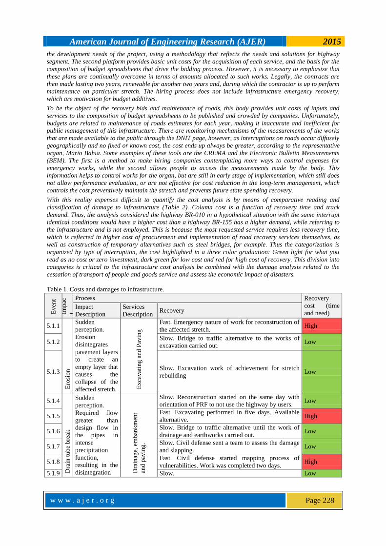
With this reality expenses difficult to quantify the cost analysis is by means of comparative reading and
classification of damage to infrastructure (Table 2). Column cost is a function of recovery time and track
demand. Thus, the analysis considered the highway BR-010 in a hypothetical situation with the same interrupt
identical conditions would have a higher cost than a highway BR-155 has a higher demand, while referring to
the infrastructure and is not employed. This is because the most requested service requires less recovery time,
which is reflected in higher cost of procurement and implementation of road recovery services themselves, as
well as construction of temporary alternatives such as steel bridges, for example. Thus the categorization is
organized by type of interruption, the cost highlighted in a three color graduation: Green light for what you
read as no cost or zero investment, dark green for low cost and red for high cost of recovery. This division into
categories is critical to the infrastructure cost analysis be combined with the damage analysis related to the
cessation of transport of people and goods service and assess the economic impact of disasters.
Table 1. Costs and damages to infrastructure.
Ev
ent
Imp
ac
t
Process Recovery
cost (time
and need) Impact
Description
Services
Description Recovery
5.1.1
Ero
sio
n
Sudden
perception.
Erosion
disintegrates
pavement layers
to create an
empty layer that
causes the
collapse of the
affected stretch. Ex
cav
atin
g a
nd
Pav
ing
Fast. Emergency nature of work for reconstruction of
the affected stretch. High
5.1.2 Slow. Bridge to traffic alternative to the works of
excavation carried out. Low
5.1.3 Slow. Excavation work of achievement for stretch
rebuilding Low
5.1.4
Dra
in t
ub
e bre
ak
Sudden
perception.
Required flow
greater than
design flow in
the pipes in
intense
precipitation
function,
resulting in the
disintegration Dra
inag
e, e
mb
ank
men
t
and
pav
ing
.
Slow. Reconstruction started on the same day with
orientation of PRF to not use the highway by users. Low
5.1.5 Fast. Excavating performed in five days. Available
alternative. High
5.1.6 Slow. Bridge to traffic alternative until the work of
drainage and earthworks carried out. Low
5.1.7 Slow. Civil defense sent a team to assess the damage
and slapping. Low
5.1.8 Fast. Civil defense started mapping process of
vulnerabilities. Work was completed two days. High
5.1.9 Slow. Low
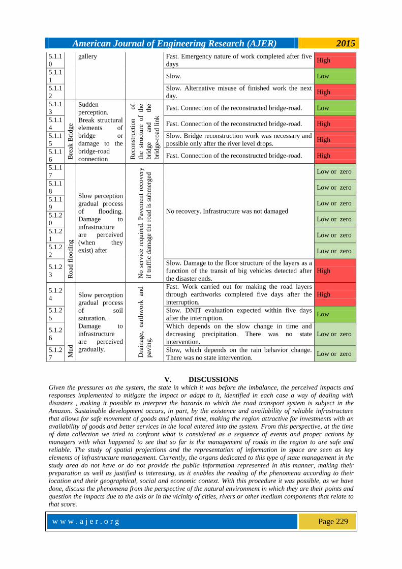
American Journal of Engineering Research (AJER) 2015
w w w . a j e r . o r g
Page 229
5.1.1
0
gallery Fast. Emergency nature of work completed after five
days High
5.1.1
1 Slow. Low
5.1.1
2
Slow. Alternative misuse of finished work the next
day. High
5.1.1
3
Bre
ak B
rid
ge
Sudden
perception.
Break structural
elements of
bridge or
damage to the
bridge-road
connection Rec
on
stru
ctio
n
of
the
stru
ctu
re o
f th
e
bri
dg
e an
d
the
bri
dg
e-ro
ad l
ink
Fast. Connection of the reconstructed bridge-road. Low
5.1.1
4 Fast. Connection of the reconstructed bridge-road. High
5.1.1
5
Slow. Bridge reconstruction work was necessary and
possible only after the river level drops. High
5.1.1
6 Fast. Connection of the reconstructed bridge-road. High
5.1.1
7
Ro
ad f
loo
din
g
Slow perception
gradual process
of flooding.
Damage to
infrastructure
are perceived
(when they
exist) after
No
ser
vic
e re
qu
ired
. P
avem
ent
reco
ver
y
if t
raff
ic d
amag
e th
e ro
ad i
s su
bm
erg
ed
No recovery. Infrastructure was not damaged
Low or zero
5.1.1
8 Low or zero
5.1.1
9 Low or zero
5.1.2
0 Low or zero
5.1.2
1 Low or zero
5.1.2
2 Low or zero
5.1.2
3
Slow. Damage to the floor structure of the layers as a
function of the transit of big vehicles detected after
the disaster ends.
High
5.1.2
4
Mu
d
Slow perception
gradual process
of soil
saturation.
Damage to
infrastructure
are perceived
gradually.
Dra
inag
e,
eart
hw
ork
an
d
pav
ing
.
Fast. Work carried out for making the road layers
through earthworks completed five days after the
interruption.
High
5.1.2
5
Slow. DNIT evaluation expected within five days
after the interruption. Low
5.1.2
6
Which depends on the slow change in time and
decreasing precipitation. There was no state
intervention.
Low or zero
5.1.2
7
Slow, which depends on the rain behavior change.
There was no state intervention. Low or zero
V. DISCUSSIONS Given the pressures on the system, the state in which it was before the imbalance, the perceived impacts and
responses implemented to mitigate the impact or adapt to it, identified in each case a way of dealing with
disasters , making it possible to interpret the hazards to which the road transport system is subject in the
Amazon. Sustainable development occurs, in part, by the existence and availability of reliable infrastructure
that allows for safe movement of goods and planned time, making the region attractive for investments with an
availability of goods and better services in the local entered into the system. From this perspective, at the time
of data collection we tried to confront what is considered as a sequence of events and proper actions by
managers with what happened to see that so far is the management of roads in the region to are safe and
reliable. The study of spatial projections and the representation of information in space are seen as key
elements of infrastructure management. Currently, the organs dedicated to this type of state management in the
study area do not have or do not provide the public information represented in this manner, making their
preparation as well as justified is interesting, as it enables the reading of the phenomena according to their
location and their geographical, social and economic context. With this procedure it was possible, as we have
done, discuss the phenomena from the perspective of the natural environment in which they are their points and
question the impacts due to the axis or in the vicinity of cities, rivers or other medium components that relate to
that score.
American Journal of Engineering Research (AJER) 2015
w w w . a j e r . o r g
Page 230
Regarding the ways in which the roads are destroyed, in whole or in part, there were different conditions,
locations, and, consequently, the reasons for each of the five types of roads for interruption raised in this study:
erosion, tube rupture culverts, bridges break, flooding and Muds. With the map reading in conjunction with the
description of the event can be established certain standards interruptions. This is realized when the local
switching relates to the description of biophysical environment where one road is located, such as where there
is greater variability in precipitation occurs interruption by the rupture of the system drains and galleries
working with higher flow rates than projected . Erosion problems were observed in the BR-364 and BR-174
highways. This disruption cause is related to the construction process and road maintenance. Erosion occurs on
adjunctive high ground to low ground. It is known that the wear and erosion is soil and rocks, usually because
of weathering. In these events the erosion of interest are the cause rain and river, related to rainfall and
flooding of rivers, respectively. These phenomena arise by the action of water wearing layers of soil that make
up the affected roads. It is understood, therefore, that intense and extreme precipitation relate to such
interruptions. In addition, the events in the far north of the country occur in May and June, while the others
occur in the first months of the year. This is because much of Roraima state is in the Northern Hemisphere and
has its rainfall regime with another configuration, concentrating the most intense rainfall in these months.
The drain tube break occurs in remote regions of the central axis of the Amazon basin. These disruptions are
related to the greater difference in flow between more and less rainy periods. This interpretation is justified by
the fact that the tube rupture occurs in the system by the occurrence of greater than the flow tube design flow,
causing the collapse of the gallery, in turn dimensioned for smaller flows, causing damage to the pavement
structure . These cases are located in areas where there are large variations in water accumulation, either by
the occurrence of extreme precipitation or by very high rainfall variability. Interruptions of roads related to
partial or total collapse of bridges relate to conditions similar to those affecting the drains pipes: large
variations in water flow between the rainy periods, affecting the systems that do not support the increased flow.
These cases were registered in the BR-230, BR-010 and BR-433. In addition to the conditions described above
adds up to poor or nonexistent maintenance of these bridges, and old, have lagged projects with 50 or more
years old, which no longer meet current traffic conditions, exacerbating the problem. By being specific
infrastructure elements, detection of problems on bridges is easier than raising a highway needs, with sufficient
carrying out bids from the state for their recovery or reconstruction, although cases such as the bridge over the
Mojú river in the state of Pará, collapsed since March 2014 (DIARIO DO PARA, 2014), show that the state
action to solve problems with bridges does not show the efficiency and effectiveness desirable, too delaying in
recovering the infrastructure creating only alternative mechanisms such as ferries to mitigate the impact of not
carrying anything.
Being phenomena caused by saturation of the soil, the Muds are amplified by the use of roads without
construction or maintenance of drainage network, which causes the accumulation of water on the axis of the
road. This is due to the need for transportation to supply certain locations. It was observed that this type of
interruption has little or no action of the managing agent of the highway to be overcome, getting your recovery
subject to rainfall and depending on traffic decrease this scheme. This has great representation of lack of
infrastructure management in Brazil in relation to natural hazards. It is common in the Amazon, the
interruption of roads quagmires for long periods, which can be months, even attractive to practitioners trails off
road. This is the non-availability infrastructure that the study describes when the road even if there is not
drivable for ordinary vehicles.
VI. CONCLUSION
The construction of the spatial database of interruptions on highways in the Amazon, and can describe the
cases, was the basis for the following steps of the thesis were developed. The point location a on a highway is
commonly reported through the kilometer reference. However, for lack of information or the domain of this
leads to reports that do not properly locate the breakpoint. A frequent example in the collection of information
was the wrong counting miles on a road informed by the news or technical report, being held from the state line
or from some influential city that was near, when the count should be done, according DNIT, from the starting
point on the route and should not start to move to another state. Although the technical manual of this body
guided this location, as I said, this did not stop being an obstacle organizing information in this way.
Because the location cannot be well presented by the news, when it came to newspapers or magazines, the data
had to go through a processing until they were clear and ready to serve as an object of analysis. More difficult
than the search, it becomes more complex management costs, causing them to become fuzzy and difficult to
interpret. In this sense, the development of the database has organized information but also serves as a guide
for one to better manage and make this information available to the public. The survey process cases led to the
perception of geographical space relations, building characteristics and features of the biophysical
environment. Note that the natural characteristic present in a region makes it quite likely that the impact will

American Journal of Engineering Research (AJER) 2015
w w w . a j e r . o r g
Page 231
happen and gets to be frustrating as certain highways are built, of course, are not appropriate to the medium in
which they are embedded. This raises questions concerning the motivation why this happens, emerging
hypotheses about the suitability of the construction and maintenance contracts made between the state and
business. This reflection interests to create and enhance the sense in the population and in public
administration, as this part of the path to sustainable development. Through the categorization and
classification of types of disasters that impact the highways in the Amazon can think about applying the same
process for other types of infrastructure that, somehow, the disrupted affect the development of a society. This
region contains a large geographical extent and therefore presents conditions of rainfall, hydrology and very
diverse geological formation. This contributes to the occurrence of the events studied. However, it is important
and perhaps the most important of the study highlight the weak and almost nonexistent performance monitoring
and maintenance of vital lines of transport in the region. Although in contrast to more populated areas and
economically developed country such as the South and Southeast, would not give the highway concession to
private enterprise, its maintenance is essential for certain aspects of regional development. Recently began the
process of granting of BR-163 highway stretches in the Mato Grosso state. That is to say that the biggest
problem is not, as is commonly presented, the natural environment is too strict with his regime of rainfall and
river flow with large basins, but the management of vital infrastructure lines in the Amazon is deficient and
needs investment to provide a new channel development to the country.
Research on management of public infrastructure should be improved and their study should be encouraged to
first show its weaknesses and then create thinking management systems in the future, considering its wear,
future development needs and future natural conditions, in particular taking into account climate change. That's
the way it should be seen the relationship between the management of infrastructure and the natural conditions
of a region, represented by infrastructure that provides services such as clean water or transport and natural
behaviors such as floods or droughts. With regard to the management of transport infrastructure, should be
thought of the current development in which it is the country, but also think the future needs are human needs or
to be imposed by the natural environment.
REFERENCES [1]. ALSDORF, B.; BATES, P.; MELACK, J.; WILSON, M.; DUNNE, T. The spatial and temporal complexity of the Amazon flood
measured from space. Geophysical Research Letters, 2007. 34 p. [2]. AMBIENTE BRASIL. Floresta Amazônica – Geologia e Relevo. Ambiente Amazônia. Available in:
http://ambientes.ambientebrasil.com.br/amazonia/floresta_amazonica/floresta_amazonica__geologia_e_relevo.html. Access:
September 22, 2014. [3]. ARAÚJO, M. Infraestrutura de transporte e desenvolvimento regional: uma abordagem de equilíbrio geral inter-regional.
Thesis (Doctorade) – Piracicaba, SP: Superior Agriculture College Luiz de Queiroz – São Paulo University, 2006.
[4]. ATLAS NATIONAL GEOGRAPHIC. Atlas National Geographic: Brasil. Editora Abril. Vol. 2. São Paulo, 2008. 96p. [5]. CEPAL. Manual para la evaluación del impacto económico y ambiental de los desastres. Naciones Unidas, Comisión
Económica para América Latina y el Caribe y el Banco Internacional de Reconstrucción y Fomento. Santiago, Chile, 2003.
[6]. CHEN, J.; WILSON, C.; TAPLEY, B. The 2009 exceptional Amazon flood and interannual terrestrial water storage change
observed by GRACE. In.: Water Resources Research., 2010. 46.
[7]. CRED. Centre for Research on the Epidemology of Disasters. Criteria and definition. Available in:
http://www.emdat.be/criteria-and-definition. Access: January 12, 2015. [8]. DALZIELL, E.; NICHOLSON, A. Risk and Impact of Natural Hazards on a Road Network. In: Journal of Transportation
Engineering, v. 127, n. 2, p. 159–166, 2001.
[9]. DIÁRIO DO PARÁ. Com ponte quebrada condutores enfrentam filas. Available in:
http://www.diarioonline.com.br/noticias/para/noticia-305068-com-ponte-quebrada-condutores-enfrent am-filas.html. Access:
January 10, 2015.
[10]. DNIT. Rodovias Federais Brasileiras. Departamento Nacional de Infraestrutura de Transportes. Available in: http://www1.dnit.gov.br/rodovias/rodoviasfederais/. Access: September 18, 2013.
[11]. DNIT. Situação das Rodovias – Chuvas 2013/2014. Ministério dos Transportes - Departamento Nacional de Infraestrutura de
Transportes. Available in: http://www.dnit.gov.br/sala-de-imprensa/ emergencias-chuvas/emergencias-tabela-05.08.14-14h.pdf. Access: August 26, 2014.
[12]. ESPINOZA, J.; RONCHAIL, J.; GUYOT, J.; COCHENEAU, G.; FILIZOLA, N.; LAVADO, W.; DE OLIVEIRA, E.; POMBOSA,
R.; VAUCHEL, P. Spatio-temporal rainfall variability in the Amazon basin countries (Brazil, Peru, Bolivia, Colombia and
Ecuador). International Journal of Climatology, 29, 1574-1594, 2009.
[13]. FARIAS, G. Cidades, Vulnerabilidade e Adaptação às Mudanças Climáticas: Um estudo na Região Metropolitana de Belém.
2012. 89f. Dissertation (Master Degree in Development Planning) – Amazonian Advanced Studies Center, Federal Universuty of Pará, Belém, 2012.
[14]. FULMER, J. What in the world is infrastructure? PEI - Infrastructure Investor. p. 30–32, 2009. [15]. HESS, L.; MELACK, J.; NOVO, E.; BARBOSA, C.; GASTIL, M.; Dual-season mapping of wetland inundation and vegetation
for the central Amazon basin. Remote sensing of environment. 87, 404-428, 2003.
[16]. IBGE. Instituto Brasileiro de Geografia e Estatística. Estimativas populacionais. Disponível em: http://www. ibge.gov.br/home/estatistica/populacao/estimativa2013/estimativa_tcu.shtm. Access: October 22, 2014.
[17]. IPCC. Climate Change 2007: Impacts, adaptation and vulnerability – contribution of working group 2 to the IPCC Fourth
Assessment Report. Cambridge University. Press, 2007. [18]. MARENGO, J.; NOBRE, C.; TOMASELLA, J.; OYAMA, M.; DE OLIVEIRA, G.; DE OLIVEIR, R.; CAMARGO, H.; ALVES, L.
The drought in Amazonia in 2005. Journal of Climate, 21, 495-516, 2008.
[19]. MARENGO, J.; TOMASELLA, J.; SOARES, W.; ALVES, L.; NOBRE, C. Extreme climatic events in the Amazon basin.
American Journal of Engineering Research (AJER) 2015
w w w . a j e r . o r g
Page 232
Theoretical and Applied Climatology, v. 107, p.73-85, 2011.
[20]. MCEER. Infrastructure Lifelines – Resource Guide | MCEER Information Service. Disponível em:
http://mceer.buffalo.edu/infoservice/reference_services/lifelines.asp. Acesso em: 12 de setembro de 2013. [21]. MELACK, J.; HESS, L.; GASTIL, M.; FORSBERG, B.; HAMILTON, S.; LIMA, I.; NOVO, E. Regionalization of methane
emissions in the Amazon basin with microwave remote sensing. Global Change Biology, 10, 530-544, 2004.
[22]. OEA. What are natural hazards? Organização dos Estados Americanos. Disponível em: https://www.oas.org/dsd/publications/Unit/oea54e/ch05.htm. Acesso em 20 de dezembro de 2014.
[23]. PAIVA, R. Hidrologia da bacia Amazônica: Compreensão e previsão com base em modelagem hidrológica-hidrodinâmica e
sensoriamento remoto. Thesis (Doctorade). Hydraulics Research Institute, Federal University of Rio Grande do Sul, Porto Alegre, 2013.
[24]. PENTEGUEL, C. Climate Change Adaptation: enabling people leaving in poverty to adapt. Oxfam Research Report, 48, 2010. [25]. PLATT, R. Lifelines: An Emergency Management Priority for the United States in the 1990s. In: Disasters, v. 15, n. 2, p. 172–
176, 1991.
[26]. RICHEY, J.; MELACK, J.; AUFDENKAMPE, A.; BALLESTER, V.; HESS, L. Outgassing from amazonian rivers and wetlands
as a large tropical source of atmospheric CO2. Nature, 416, 617-620, 2002.
[27]. SENA, J.; DEUS, L.; FREITAS, M.; COSTA, L. Extreme events of droughts and floods in Amazonia: 2005 and 2009. Water
Resources Management. v. 26, p. 1665-1676. 2012.
[28]. SEVILLE, E. Resilience: Great Concept but What Does it Mean?. Wilmington, USA: Council on Competitiveness - Risk
Intelligence and Resilience Workshop, Nov, 2008.
[29]. SZLAFSZTEIN, C. 2003. Vulnerability and response measures to natural hazard and sea level rise impacts: long-term coastal
zone management, NE of the State of Pará, Brazil. ZMT-Contribution 17. Bremen, 2003.
[30]. SZLAFSZTEIN, C.; STERR, H. A GIS-based vulnerability assessments coastal natural hazards, state of Pará, Brazil. Journal of
Coastal Conservation. Vol. 11, No. 1, pp. 53-66, 2007. [31]. SZLAFSZTEIN, C. Climate change, Sea-level rise and Coastal Natural Hazards: A GIS-Based Vulnerability Assessment, State
of Pará, Brazil. Human Security and Climate Change, an international workshop. Oslo, 2005
[32]. SZLAFSZTEIN, C. Natural Disaster Management in the Brazilian Amazon: An Analysis of the States of Acre, Amazonas and
Pará. Natural Disasters, Dr. Sorin Cheval (Ed.), ISBN: 978-953-51-0188-8, InTech, 2012.
[33]. SULLIVAN, A; STEVEN, M. Economics: Principles in action. Ed. Pearson Prentice Hall. p. 474. ISBN 0-13-063085-3. New
Jersey, 2003. [34]. TOMASELLA, J.; BORMA, L.; MARENGO, J.; RODRIGUEZ, D.; CUARTAS, L.; NOBRE, C.; PRADO, M. The droughts 1996-
1997 and 2004-2005 in Amazonia: hydrological response in the river main-stem. Hydrological Processes. 25, 8, 1228-1242,
DOI 10.1002/hyp.7889, 2010. [35]. TOMASELLA, J.; PINHO, P.; BORMA, L.; MARENGO, J.; NOBRE, C.; BITTERNCOURT, O.; PRADO, M.; RODRIGUEZ, D.;
CUARTAS, L. The droughts of 1997 and 2005 in Amazonia: floodplain, hydrology and its potential ecological and human
impacts. Climatic Change, n. 2, p. 1-24, 2012. [36]. UN-ISDR. The United Nations Office for Disaster Reduction - Terminology. Organização das Nações Unidas, 2009. Available
in: http://www.unisdr.org/files/7817_UNISDRTerminology English.pdf. Access: September 12, 2013.
[37]. ZMITROWICZ, W.; ANGELIS NETO, G. Infra-estrutura Urbana. São Paulo University Politechnic College Technical Report, Civil Construction Engineering Departament, TT/PCC, v. 17, EPUSP, 1997.