the sea - supplement to hydrocarbons and geothermal...
TRANSCRIPT

M I N I STR Y O F E CO NOM I C DEVE LO PM E NT
ENERGY DEPARTMENT DIRECTORATE-GENERAL FOR MINERAL AND ENERGY RESOURCES
Year LVII - N. 2 February 28th, 2013
THE SEA
S U P P L E M E N T T O
HYDROCARBONS AND
GEOTHERMAL RESOURCES
OFFICIAL BULLETIN Year LVII N.2 - February 28th, 2013
DIRECTORATE-GENERAL FOR MINERAL AND ENERGY RESOURCES
http://unmig.sviluppoeconomico.gov.it

M I N I S T R Y O F E C O N O M I C D E V E L O P M E N T
ENERGY DEPARTMENT DIRECTORATE-GENERAL FOR MINERAL AND ENERGY RESOURCES
Year LVII - N. 2 February 28th, 2013
THE SEA
S U P P L E M E N T T O
HYDROCARBONS AND GEOTHERMAL RESOURCES
OFFICIAL BULLETIN Year LVII N.2 - February 28th, 2013
DIRECTORATE-GENERAL FOR MINERAL AND ENERGY RESOURCES
http://unmig.sviluppoeconomico.gov.it

Responsib le Director: OMBRETTA COPPI
Draft ing: NICOLA SANTOCCHI – ANNA LIGATO – ANTONELLA ORLANDI – MARIA PIA PELLEGRINI Col laborators for this specia l edi t ion : ILARIA ANTONCECCHI – ANDREE SOLEDAD BONETTI –
LUCA DI DONATANTONIO – RAFFAELLA MASTRELLA – MARIA GIOVANNA MONTALBANO
THE SEA - Supplement to Hydrocarbons and Geothermal Resources Official Bulletin - Year LVII N. 2 - February 28th, 2013
3

SUMMARY
PREFACE .................................................................................................................. 6 INTRODUCTION ........................................................................................................ 7
THE SEA
TERRITORIAL SEA AND CONTINENTAL SHELF
Internal waters, baselines and Territorial sea ................................................................ 8 Table of baselines and limit of territorial sea ................................................................. 9 Continental shelf ..................................................................................................... 10 Italian continental shelf ............................................................................................ 10 Exclusive Economic Zone(ZEE) .................................................................................. 10 Table of the Italian continental shelf .......................................................................... 11
AGREEMENTS AND CONVENTIONS IN THE MEDITERRANEAN SEA
CROATIA (former Yugoslavia) – Agreements ratified by Presidential Decree No. 830 of
May 22, 1969, and Law No. 73 of March 14, 1977. ................................................. 12 TUNISIA – Agreement ratified by Law No. 347 of June 3, 1978. ................................... 13 GREECE – Agreement ratified by Law No. 290 of March23, 1980. .................................. 14 ALBANIA – Agreement ratified by La, No. 147 of April 12, 1995. ................................... 15 SPAIN – Agreement ratified by Law No. 348 of June 3, 1978. ...................................... 16 FRANCE – Italy-France Convention of November 28,1986........................................... 17
MODUS VIVENDI
MALTA – Modus vivendi dal 29 aprile 1970. ................................................................ 18
OFFSHORE MINING ACTIVITIES
MARINE AREAS OPEN TO EXPLORATION AND EXPLOITATION OF OIL & GAS
Tables of marine zones ............................................................................................ 19 ZONE “A” – Northern and Central Adriatic Sea ............................................................ 20 ZONE “B” – Central and Southern Adriatic Sea ............................................................ 21 ZONE “C” – Southern Tyrrhenian and Ionian Seas, Sicily Channel.................................. 22 ZONE ”D” – Adriatic and Ionian Seas. ........................................................................ 23 ZONE “E” – Ligurian and Tyrrhenian Seas, Sea of Sardinia ........................................... 24 ZONE F – Southern Adriatic and Ionian Seas. ............................................................. 25 ZONA “G” – Tyrrhenian Sea and Sicily Channel. .......................................................... 26 Criteria and standards relating to restrictions on mining activities ................................. 27
HYDROCARBON EXPLORATION AND EXPLOITATION OFFSHORE ACTIVITIES
OVERVIEW OF REGIONAL GEOLOGY
Geological Evolution of the Italian Seas ...................................................................... 28 Geological features .................................................................................................. 31 The most important offshore deposits ........................................................................ 32 The most significant stages of exploration in the italian seas ........................................ 34
MINING LICENSES
Exploration permits ................................................................................................. 35 Exploitation concessions ........................................................................................... 37 Map of active mining licenses at sea .......................................................................... 40
DRILLING ACTIVITIES
Historical Data ........................................................................................................ 41 Drilling Activities at sea in the year 2012.................................................................... 43 VIDEPI Project – Publication of the data related to the hydrocarbon exploration in Italy ... 44
THE SEA - Supplement to Hydrocarbons and Geothermal Resources Official Bulletin - Year LVII N. 2 - February 28th, 2013
4
PRODUCTION ACTIVITIES
Historical data......................................................................................................... 44 Producing wells ....................................................................................................... 47 Gathering and treatment centers ............................................................................... 49 Offshore Platforms................................................................................................... 51
NATIONAL ENERGY STRATEGY (SEN)
The goals and priorities of action ............................................................................... 55
SAFETY AND ENVIRONMENTAL PROTECTION IN OFFSHORE ACTIVITIES
A global overview .................................................................................................... 57 A continental overview ............................................................................................. 57 A national overview ................................................................................................. 57 “After Macondo”: Proposal For An Offshore Regulation, EUOAG And Adhesion To The
Offshore Protocol ................................................................................................ 58
LEGAL FRAMEWORK
Introduction ........................................................................................................... 59 Agreements with Riparian Countries .......................................................................... 59 Main laws about marinE zones of offshore activities ..................................................... 59 Main procedural laws about mining activities .............................................................. 60 Main regulations on safety and environmental protection ............................................. 60
LIST OF COMPANIES OPERATING IN THE ITALIAN OFFSHORE
Companies with offshore exploration permit licenses ................................................... 63 Companies with offshore exploitation concessions ....................................................... 64
ITALIAN DIVING ENTERPRISES ASSOCIATION (A.I.S.I.)
List of aisi members ................................................................................................ 66
BIBLIOGRAPHY
References ............................................................................................................. 67
THE SEA - Supplement to Hydrocarbons and Geothermal Resources Official Bulletin - Year LVII N. 2 - February 28th, 2013
5

PREFACE
Since the beginning of the 20th Century, hydrocarbons became more and more important, firstly for industrialized countries’ economies and then for all economies worldwide. Thanks to hydrocarbons, Countries can manage their industries and produce other forms of energy, essential for society well
being. This is the main reason for the deep modifications implemented during the last Century on the legal framework with reference to hydrocarbons exploitation. These transformations, finally adopted and formalized with the United Nations Convention on the Law of the Sea (UNCLOS - 1982), brought finally to the elimination of the dichotomy between definitions of high sea, based on a freedom regime, and of territorial sea, subjected to the coastal Countries sovereignty, and to the creation of “intermediate” marine zones characterized by a combination of high and territorial sea regimes. Among these “intermediate” marine zone, the most important for the hydrocarbons exploitation activities are the
continental shelf and the Economical Exclusive Zone.
Even if the regulatory regime for the exploitation of marine resources, hydrocarbons in particular, changes based on the zones where resources are located, it has to be noticed that beyond territorial waters, therefore within the continental shelf and the Economical Exclusive Zone, the sole coastal State have authority with reference to activities of exploration and production of mineral resources and
hydrocarbons; other activities, instead, are still subjected to the ancient seas freedom regime.The unique
resources which are not under the control of the coastal State are the mineral resources and hydrocarbons located in deep waters, which are subjected to a new equitable regime defined as “humanity common heritage”.
At the same time, since hydrocarbons and marine mineral resources are spatially precisely located, it is very important the resolution of conflicts due to claims of different countries on the same sea or seabed
portions located within territorial seas and economic exclusive zones. However, the regime of marine delimitation is not homogeneous: while for the territorial seas is applied the rule of median line, for the continental base and the Exclusive Economic Zone, instead, is applied the principle of "equitable solution". The contents of this principle has been made explicit by international jurisprudence, which focused on the idea that a certain proportion must exist between the length of relevant coasts and the extension of marine areas assigned to a coastal State and took into account several geographical features.
The extent and the complexity of the international normative framework applicable to off shore hydrocarbon exploitation underline the importance of this publication “The sea, framework and mining activities. Supplement to hydrocarbons and geothermal resources official bulletin”, mainly due to its main purpose of spreading among specialists sector the national and International legal framework in a simple
and synthetic manner, with the aim of facilitating an efficient economic management - for the States and
for the Operators - of marine resources.
Prof. Umberto Leanza
THE SEA - Supplement to Hydrocarbons and Geothermal Resources Official Bulletin - Year LVII N. 2 - February 28th, 2013
6

INTRODUCTION
This publication, focused on off-shore hydrocarbons exploration and production, collects all information, data, criteria and legal frameworks regulating these activities as well as most recent developments and normative modifications.
Italy, surrounded by about 7.500km of coasts facing the Mediterranean Sea, is naturally located in a privileged and strategic geographical position, and hydrocarbon found in the marine subsoil are a valuable resource to be exploited for further economic developments and to achieve a certain energy security for the Country. As well known, the quantity of hydrocarbons produced offshore in Italy, represents the 71% of the national gas production and the 8% of oil production, offsetting about the 4% of national energy consumption. For these reasons, mining activities are the fourth pillar of the National Energy Strategy, which is currently being adopted.
Hydrocarbon reservoirs – Country non-disposable asset – are studied and developed, based on a sectorial legal framework, by enterprises with an adequate technical and economical capacity, within mining concessions located in the Italian Seas areas and available for mining activities. These areas of territorial waters and continental shelf are defined through Decrees of the Ministry of Economic Development, based on scientific and geologic knowledge demonstrating their mining importance for the Country and for sectorial operators.
In order to define the boundaries of its own continental shelf, Italy has signed specific international
agreements with the most part of frontage or neighboring Countries (Slovenia, Croatia, Albania, Montenegro, Greece, Libya, Malta, Tunisia, Spain, France). In order to complete the opening of marine areas within the Sicily Channel and into the southern Ionic Sea, only the agreements with Malta and Libya still remain to be signed. Within international relations activities, in case of reservoirs shared with frontage Countries, some particular types of collaborations are foreseen: for example with the Croatia is in force a specific technical agreement, while a technical study group has been recently created in order
to examine the issue in depth with the Republic of Malta. At an international level, our Country has one of the most strict normative framework and has a consolidated sectorial experience with reference to safety standards and procedures and to environmental protection; currently Italy is strongly involved in the definition of the European Directive for the Safety of Off-shore activities. Moreover, considering its strategic position in the Mediterranean Sea, Italy is naturally candidate as a mediator for the relationships with extra European Countries adopting the Barcelona Convention – tool for the international cooperation at a regional level finalized at the
Mediterranean Sea protection. Considering the strong interests generated by the hydrocarbon exploration and production sector in terms of economic and industrial development, national security and political issues, safety and environmental impacts, the “Bollettino del Mare” was developed in order to inform, in a complete but synthetic manner, all the stakeholders.
CATANZARO
BARI
POTENZA
CAMPOBASSO
NAPOLI
PALERMO
TRIESTE
L'AQUILA
ANCONA
ROMA
PERUGIA
VENEZIA
BOLOGNA
FIRENZE
TRENTO
MILANO
CAGLIARI
GENOVA
TORINO
AOSTA
T U N I S I A
F R
A N
C I
A
S V I
Z Z E
R A
A L G E R I A
C O R S I C A
A U S T R I A
ISOLA
DI
MALTA
S L O V E N I A
C R O A Z I A
B O S N I A -
E R Z E G O V I N A
M O
N T E N
E G
R O
A L
B A
N I A
ZONA C
ZONA C
ZONA C
ZONA G
ZONA G
ZONA F
ZONA E
ZONA E
ZONA B
ZONA A
ZONA D
M A R E
I O N I OIso la S tro mb o li
Isola PanareaISOLE EOLIE
Isola Lipar i
Isola Vulcano
Isola Salina
ISOLE PELAGIE
Isola di Linosa
Isolotto Lampione
C A N A L E D I S I C I L I A
Isola Filicudi
Isola Alicudi
Isola di Us tica
Isola di Panteller ia
Isola di Lampedusa
Isola di
LevanzoIsola di
Favignana
ISOLE EGADI
Isola di Marettimo
Iso la Pia n o sa
IS OLE TREM ITI
M A R E A D R I A T I C O
Iso la d i Pro cid a
Iso la d ' Isch ia
IS OLE PONTINE
Iso la d i Ven to ten e
Iso la
Pa lma ro laIso la Za n o n e
Iso la d i Po n za
Iso la d i Ca p ri
M A R E
T I R R E N O
Iso la d i M o n tecristo
Iso la d el Gig lio
Iso la d 'Elb aARCIPELAGO
TOS CANO
Iso la Pia n o sa
Iso la d i Go rg o n a
Iso la d i Ca p ra ia
Fiume Base nto
Fiume Brad an o
La g o d i
Va ra n oLa g o d i Lesin a
Fiume V
oltur no
Fiume Teve re
Fiume Piave
La g o d i
Bra ccia n o
La g o
Tra simen o
Fium
e T
evere
La g o d i
Bo lsen a
La g o d i
Vico
Va lli d i
Co ma cch io
Fiume Po
Fiume A
dige
Fiume A
rno
La g o d i
Ga rd a
Fiume Po
La g o d i
Co mo
La g o d ' IseoLa g o
M a g g io re
La g o d i
Lu g a n o
La g o
d 'Orta
Fiume Po
THE SEA - Supplement to Hydrocarbons and Geothermal Resources Official Bulletin - Year LVII N. 2 - February 28th, 2013
7

THE SEA
TERRITORIAL SEA AND CONTINENTAL SHELF
INTERNAL WATERS, BASELINES AND TERRITORIAL SEA
The Law No. 689 of December 2, 1994, provides, in accordance with the principles of the United Nations
Convention on the Law of the Sea of 1982, that the sovereignty of a coastal State extends, beyond its
land territory and internal waters to an adjacent belt of sea described as the territorial sea. The
sovereignty also extends to the air space over the territorial sea as well as to its seabed and subsoil.
A Territorial sea, or territorial waters, is a belt of coastal waters extending at most 12 nautical miles from
the baseline of a coastal state.
The normal baselines overlaps with the coastline as marked on large-scale charts officially recognized by
the coastal State, and, in this case, there are no internal waters.
In localities where the coastline is deeply indented and sunken, or if there is a fringe of islands along the
coast in its immediate vicinity, the method of straight baselines joining appropriate points (generally
promontories) may be employed in drawing the baseline from which the breadth of the territorial sea is
measured.
In this case, the sea area lying within the coast line and the baseline is considered as internal waters.
Delimitation of the Baselines and internal waters in Taranto Gulf
Pursuant to the Presidential Decree No. 816 of April 26, 1973 , Italy has adopted the straight baseline
system, providing a considerable simplification of the outer limit of the territorial sea and the islands. This
method is based on 21 straight lines drawn along the coasts of the peninsula, and respectively 10 and 7
ones around Sicily and Sardinia. The main provisions of the Decree define the areas bounded by lines
i.e.:
- the Tuscan Archipelago starting from the mouth of the Arno River, near Pisa, joining the islands of Gorgona, Capraia, Elba, Pianosa, Scoglio d’Africa, Montecristo, Giglio, and Giannutri, and back
to the coast of Civitavecchia;
CAN
ALE
DI O
TRAN
TO
LIM
ITE P
IATTAFO
RM
A C
ON
TIN
EN
TALE I
TALIA
NA
12 m
m
24 m
m
limite
acque territ
oriali
GOLFO DI
TARANTO
linee di base
MARE
IONIOlim
ite zo
na contig
ua
THE SEA - Supplement to Hydrocarbons and Geothermal Resources Official Bulletin - Year LVII N. 2 - February 28th, 2013
8

- the Pontine Islands and the Gulf of Naples and Salerno drawing lines connecting Anzio, the islands of Palmarola, Ponza, Ischia and Capri, and the southern end of the Gulf of Salerno;
- the Gulf of Squillace and, as a historic bay, the Gulf of Taranto; - the Gulf of Manfredonia and the Tremiti Islands connecting Peschici, the Tremiti islands, Termoli
and Punta Penna located north-east of Vasto;
- the Gulf of Venice from Punta della Maestra to Ponte di Piave.
TABLE OF BASELINES AND LIMIT OF TERRITORIAL SEA
(According to the Presidential Decree No. 816 the April 26, 1973)
Delimitation of the Baselines and internal waters
AOSTA
TORINO
GENOVA
MILANO
CAGLIARI
TRENTO
FIRENZE
BOLOGNA
PERUGIA
ROMA
VENEZIA
TRIESTE
ANCONA
PALERMO
L'AQUILA
CAMPOBASSO
POTENZA
BARI
CATANZARO
NAPOLI
CANALE DI SICILIA
MARE
IONIO
MARE ADRIATICO
MARE
TIRRENO
MARE
DI
SARDEGNA
MAR LIGURE
THE SEA - Supplement to Hydrocarbons and Geothermal Resources Official Bulletin - Year LVII N. 2 - February 28th, 2013
9

CONTINENTAL SHELF
The continental shelf of a coastal State, according to the principles of the United Nations Convention on
the Law of the Sea of 1982, comprises the seabed and subsoil of the submarine areas that extend beyond
its territorial sea throughout the natural prolongation of its land territory to the outer edge of the
continental margin, or to a distance of 200 nautical miles from the baselines. The outer limit of the
continental shelf does not exceed a distance of 350 miles from the baselines.
The coastal State exercises over the continental shelf sovereign rights for the purpose of exploring it and
exploiting its natural resources, no one may undertake these activities without the express consent of the
coastal State. Natural resources consists of the mineral and other non-living resources of the seabed and
subsoil.
The delimitation of the continental shelf between States with opposite or adjacent coasts is established by
agreements based on international law.
ITALIAN CONTINENTAL SHELF
The principles adopted by Italy for the regulation of the exploration and exploitation of hydrocarbons
from her continental shelf are established by the Law No. 613 of July 21, 1967. This law fixes the rules
for the release of exploration permits establishing that, in accordance with the provisions of the Fourth
Geneva Convention of 1958, limit of the Italian continental shelf is delimited by the 200-metres isobath,
or beyond that limit, where the depth of the subjacent waters admit the exploitations of natural resources
up to the median line between the opposite coasts of Italy and the neighboring State, unless
delimitations lines are to be agreed with bilateral treaty in the future. The Law No. 689 of December
2,1994, ratifies the execution of the United Nations Convention on the Law of the Sea concluded at
Montego Bay on December 10, 1982.
The definition of the continental shelf, as embodied in Art. 1 of Law No. 613/1967, is replaced by the
provision in Art. 76 of the United Nations Convention on the Law of the Sea of December 10, 1982.
EXCLUSIVE ECONOMIC ZONE(ZEE)
Appears besides opportune to mention the juridical regime related to the Exclusive Economic Zone ("ZEE") since, even though Italy has not ESTABLISHED an own ZEE, said normative will interest the juridical operators since numerous are the States in the Mediterranean, also adjoining or frontagers of
Italy, that already has their own ZEE.
The Exclusive Economic Zone (ZEE), includes the column of water towering above the bottom of the sea.
It extends beyond the territorial sea over the 200 sea miles from the base lines.
In the ZEE the coastal state enjoys of:
- sovereign rights for the purposes of the exploration, of the exploitation, of the conservation and of the management of the natural resources, biological and or not biological, that are found in the waters above the seabed, on the seabed of the sea and in the relative subsoil, both to the goals of other connected activities with the exploration and of the economic exploitation of the zone, which production of energy
derived by the water, by the sea tides and by the winds.
The ZEE, to become effective, must formally be proclaimed towards the international community. This, unlike the continental shelf, that constituting a natural submerged prolongation of the land, it belongs instead ab initio to State and should not be proclaimed.
The delimitation of the ZEE between States with opposite or adjacent coasts shall be effected by agreement on the basis of international law. (Article 74 - Law no. 689/94).
There is no obligation to match the ZEE and continental shelf, although the normal case is the complete
overlap between the two areas, within the limit of 200 miles from the baselines of the territorial sea, it is possible that the delimitation of the seabed that belongs to the continental shelf of a State differs from the above water column in which the state itself has ownership within the ZEE.
In the Mediterranean the Countries that have founded their own ZEE are: Egypt, Cyprus, Lebanon, Syria, Tunisia and Israel.
THE SEA - Supplement to Hydrocarbons and Geothermal Resources Official Bulletin - Year LVII N. 2 - February 28th, 2013
10

TABLE OF THE ITALIAN CONTINENTAL SHELF
In accordance with the agreements between Italy and Croatia, Republic of Albania, Greece, France, Spain, Tunisia.
CROATIA FRANCE ALBANIA SPAIN GREECE TUNISIA
Boundary Lines of the Italian Continental shelf
THE SEA - Supplement to Hydrocarbons and Geothermal Resources Official Bulletin - Year LVII N. 2 - February 28th, 2013
11

AGREEMENTS AND CONVENTIONS IN THE MEDITERRANEAN SEA
CROATIA (FORMER YUGOSLAVIA) – Agreements ratified by Presidential Decree No. 830 of May 22, 1969, and Law No. 73 of March 14, 1977.
The Agreement between Italian Republic and the Socialist Federal Republic of Yugoslavia of January 8,1968, (ratified by the Decree of the President of the Republic , No. 830 of May 22, 1969 and in force since 21 January 1970) conforms to the principle of the median line equidistant from the coasts of the two States, attributing a void or minimum effect, in tracing the delimitations in the case of the Yugoslavian small islands of Pelagosa, Pomo and S. Andrea. Also, exceptions were made in favour of
Italy, as part of compensation for the two islands of Jabuka and Galiola. Afterwards, the Law No. 73 of March 14, 1977, ratifying the execution of the Agreement between the Italian Republic and the Socialist Federal Republic of Yugoslavia, has defined the dividing line between the Gulf of Venice and Slovenia. States emerging from the break-up of the Socialist Federal Republic of Yugoslavia have taken over the international agreements signed with Italy, in accordance with the principles of the General Succession of
Bilateral Agreements. Within the frame of the 1968 Agreement Italy and Croatia signed: the Technical Agreement in 2005 adopting the use of WGS 84 allowing an accurate determination
of the delimitation lines of the Italian and Croatian continental shelves which were reviewed. The Technical Agreement in 2009 guaranteeing the exploitation of the Annamaria Gas Field in the
Adriatic Sea which lies on both sides of the delimitation line between the continental shelves of the two states.
This settlement was substituted by a new Technical Agreement in 2012 between the Ministry of Economic Development of the Italian Republic (Directorate General for Energy and Mineral Resources) and the Ministry of Economy, Labour and Entrepreneurship of the Republic of Croatia (Directorate for Mining) on the Joint Exploitation of the Annamaria Gas Field in the Adriatic Sea.
Italy – Croatia Boundary Lines
THE SEA - Supplement to Hydrocarbons and Geothermal Resources Official Bulletin - Year LVII N. 2 - February 28th, 2013
12

TUNISIA – Agreement ratified by Law No. 347 of June 3, 1978.
The Agreement for the delimitation of the continental shelf between the Italian Republic and the Republic of Tunisia of 28 August 1971, (ratified by Law of 3 June 1978, No. 347 and entered into force since 16
December 1978), applies to the South Central Mediterranean Sea the method of drawing the median line equidistant between the opposite coasts of Tunisia and Sicily. It does not give relevance to the “special circumstances” of the islands of Pantelleria, Lampedusa, Linosa and the isle of Lampione. In this case the portion of the platform is delimited by arcs of respectively 13 and 12 mile range, which overlap the territorial waters of those islands with the exception of Pantelleria.
Italy - Tunisia Boundary Lines
THE SEA - Supplement to Hydrocarbons and Geothermal Resources Official Bulletin - Year LVII N. 2 - February 28th, 2013
13

GREECE – Agreement ratified by Law No. 290 of March23, 1980.
The Agreement between the Italian Republic and the Hellenic Republic of May 24, 1977, (ratified by Law of 23 March 1980, No. 290 and in force since July 3, 1980), establishes the delimitation of the continental
shelf taking into consideration Zante, Cefalonia, Leucade, Corfu and the Strofade Islands. The only exception is the Isle of Fano, whose effect is reduced.
Italy – Greece Boundary Lines
THE SEA - Supplement to Hydrocarbons and Geothermal Resources Official Bulletin - Year LVII N. 2 - February 28th, 2013
14

ALBANIA – Agreement ratified by La, No. 147 of April 12, 1995.
The Agreement between the Italian Republic and the Republic of Albania was signed on 18 December of
1995, (ratified by the Law No. 147 of April 12, 1995, and entered into force since February 26, 1999).The delimitation of the continental shelf follows the criterion of equidistance from respective baselines, and it does not take into account the straight lines that join points of their coastal baselines. The agreement sets that:
- the delimitation ends outside the triple points area of the boundary line of Greece and Federal Republic of Jugoslavia (delimitation to be agreed by future treaty with States concerned);
- is done except for the legal regime of the waters and the air space above the continental shelf; - there are defined criteria (proportionality and compensation) for the exploitation of deposits
that may exist straddling the boundary lines; - the contracting parties take all possible measures to ensure that the explorations and the
exploitations of natural resources do not affect the ecological balance of the sea or unjustifiably interfere with other legitimate use of it.
Italy- Albania Boundary Lines
THE SEA - Supplement to Hydrocarbons and Geothermal Resources Official Bulletin - Year LVII N. 2 - February 28th, 2013
15

SPAIN – Agreement ratified by Law No. 348 of June 3, 1978.
The Agreement between the Italian Republic and the Spanish State signed on February 19, 1974,
(ratified by Law No. 348 of June 3, 1978, and entered into force since 16 November, 1978), delimit the
continental shelf boundary between the islands of Sardinia and Minorca according to the criterion of
equidistance. The line, drawn slightly concave, gives greater prominence to the coastline of Sardinia over
the island of Minorca. Objections were raised by France as she claims rights on a portion of the area of
the continental shelf shared by Italy and Spain.
Italy– Spain Boundary Lines
THE SEA - Supplement to Hydrocarbons and Geothermal Resources Official Bulletin - Year LVII N. 2 - February 28th, 2013
16
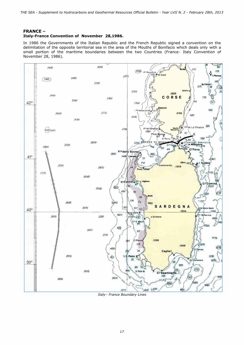
FRANCE – Italy-France Convention of November 28,1986.
In 1986 the Governments of the Italian Republic and the French Republic signed a convention on the delimitation of the opposite territorial sea in the area of the Mouths of Bonifacio which deals only with a
small portion of the maritime boundaries between the two Countries (France- Italy Convention of November 28, 1986).
Italy– France Boundary Lines
THE SEA - Supplement to Hydrocarbons and Geothermal Resources Official Bulletin - Year LVII N. 2 - February 28th, 2013
17

MODUS VIVENDI
MALTA – MODUS VIVENDI DAL 29 APRILE 1970.
An informal modus vivendi is in place between Italy and Malta, established by Exchange of notes of April 29, 1970, agreeing the provisional and partial delimitation of seabed within the 200-metres applying the median line criterion between the northern coast of Malta and opposite coast of Sicily.
The segment of the Modus vivendi ITALY –MALTA which
does not provisionally overlap with the equidistance line, is slightly shifted to the north of the Italian coasts, is defined by the following geographical coordinates:
Limits of the judgment of the 3/06/85 of the C.I.G.
- vertex A Lat. N 36°27’ - Long. W 14°23’ - vertex B Lat. N 36°02’ - Long. W 15°23’
In the dispute between Malta and Libya for the
delimitation of their respective continental shelves brought before the International Court of Justice, Italy applied for her interests in two geographical areas: the first one bounded on the west by the meridian 15 ° 10’ , on the south by the parallel 34 ° 30’ , on the east by the line agreed between Italy and Greece, and the second
one bounded by the polygon shown in the map on the west of the meridian 13 ° 50'.
By judgment of June 3, 1985 the Court, that didn’t recognized to Italy an interest worthy of protection, has decided that the Agreement between Malta and Libya was to be limited to the area between the meridians 13 ° 50 'and 15 ° 10', so as not to interfere with third-party interests, including Italy. During 2012, the General Director of mineral and energy resources, on behalf of the Minister of Economic Development and in agreement with the Minister for Foreign Affairs, has promoted the resumption of
relations with the Maltese authorities on the issue related to the exploitation of the continental shelf. The Italian Government is ready to negotiate, within legal and technical frameworks, a preliminary agreement
on the delimitation of the continental shelf and without prejudice to the sovereign rights of both States, according to the provision of Article 83 of UNCLOS.
Italy - Malta Boundary Lines
A
B
T U
N I S I A
L I B I A
ISOLA
DI
MALTA
200
200200
200
200
1000
100
0
200
200
Banco Medina
1000
1000
2000
200
0
2000
354
530
330
410
200
100
0
50
50
1000
1000
200
545
292
510
550
179
146
100
0
3000
3620
30003000
C A N A L E D I S I C I L I A
13°50'
13°50'
X
G34°20'
15°10'
I T A L I A
34°30'
15°10'
THE SEA - Supplement to Hydrocarbons and Geothermal Resources Official Bulletin - Year LVII N. 2 - February 28th, 2013
18

OFFSHORE MINING ACTIVITIES
MARINE AREAS OPEN TO EXPLORATION AND EXPLOITATION OF OIL & GAS
BOUNDARIES, TABLES, LAWS AND REGULATIONS
TABLES OF MARINE ZONES
Licenses of exploration and exploitation of hydrocarbons in the offshore are granted by the Ministry of Economic Development in the areas of the continental shelf governed by Italian laws and ministerial decrees. They are called "marine zones" and named with capital letters. The Law No. 613/67 has defined five marine zones (from A to E), while two additional sections F and G have been later opened by ministerial decrees. The total surface of all the areas opened to mining
activities is about the 40% of the Italian continental shelf.
Marine Zones open to mining activities
CATANZARO
BARI
POTENZA
CAMPOBASSO
NAPOLI
PALERMO
TRIESTE
L'AQUILA
ANCONA
ROMA
PERUGIA
VENEZIA
BOLOGNA
FIRENZE
TRENTO
MILANO
CAGLIARI
GENOVA
TORINO
AOSTA
T U
N I S
I A
F R
A N
C I
A
S V I Z Z E R A
A L G E R I A
C O R S I C A
A U S T R I A
ISOLA
DI
MALTA
S L O V E N I A
C R O A
Z I A
B O S N I A
-
E R Z E G O V
I N A
M O
N T E N
E G
R O
A L
B A
N I A
ZONA C
ZONA C
ZONA C
ZONA G
ZONA G
ZONA F
ZONA E
ZONA E
ZONA B
ZONA A
ZONA D
M A R E
I O N I O
Iso la S tro mb o li
Isola Panarea
ISOLE EOLIE
Isola Lipar i
Isola Vulcano
Isola Salina
ISOLE PELAGIE
Isola di Linosa
Isolotto Lampione
C A N A L E D I S I C I L I A
Isola Filicudi
Isola Alicudi
Isola di Us tica
Isola di Panteller ia
Isola di Lampedusa
Isola di
LevanzoIsola di
FavignanaISOLE EGADI
Isola di Marettimo
Iso la Pia n o saIS OLE TREM ITI
M A R E A D
R I A T I C O
Iso la d i Pro cid a
Iso la d ' Isch ia
IS OLE PONTINE
Iso la d i Ven to ten e
Iso la
Pa lma ro laIso la Za n o n e
Iso la d i Po n za
Iso la d i Ca p riM A R E
T I R R E N O
Iso la d i M o n tecristo
Iso la d el Gig lio
Iso la d 'Elb a
ARCIPELAGO
TOS CANO
Iso la Pia n o sa
Iso la d i Go rg o n a
Iso la d i Ca p ra ia
Fiume Base nto
Fiume Brad an o
La g o d i
Va ra n o
La g o d i Lesin a
Fiume Volturno
Fiume Teve re
Fiume Piave
La g o d i
Bra ccia n o
La g o
Tra simen o
Fium
e T
evere
La g o d i
Bo lsen a
La g o d i
Vico
Va lli d i
Co ma cch io
Fiume Po
Fiume A
dige
Fiume Arno
La g o d i
Ga rd a
Fiume Po
La g o d i
Co mo
La g o d ' Iseo
La g o
M a g g io re
La g o d i
Lu g a n o
La g o
d 'Orta
Fiume Po
THE SEA - Supplement to Hydrocarbons and Geothermal Resources Official Bulletin - Year LVII N. 2 - February 28th, 2013
19

ZONE “A” – NORTHERN AND CENTRAL ADRIATIC SEA
This zone is located in the Adriatic Sea and extends to the parallel 44°00; it is delimited on the west by the coastline of the regions of Friuli-Venezia Giulia, Veneto and Emilia Romagna ,and on the east by the boundary lines between Italy and Slovenia and between Italy and Croatia.
The Law of 9 January 1991, n. 9 “Norme per l’attuazione del nuovo Piano energetico nazionale” – established the following areas closed entirely to oil and gas exploration and exploitation: Gulf of Venice – in the belt of the sea extending from the parallel lying on the mouth of Tagliamento River, and the parallel lying on the mouth of the Po River Goro channel. The A Zone covers approximately 13.300 sq. km. and represents about the 2% of the Italian continental shelf. Local office competent for mining activities: Territorial Office UNMIG in Bologna.
Marine zone “A”
References:
- Legge 21 luglio 1967 n. 613 Ricerca e coltivazione degli idrocarburi liquidi e gassosi nel mare territoriale e nella piattaforma
continentale - Legge 9 gennaio 1991 n. 9
Norme per l'attuazione del nuovo Piano energetico nazionale - Comunicato Ministeriale 30 settembre 2005
Correzione tecnica della linea di delimitazione della piattaforma continentale comune italo-croata
- Comunicato Ministeriale 31 maggio 2006 Delimitazione delle zone marine "A", "B" e "F" in seguito alla correzione tecnica della linea di delimitazione della piattaforma continentale comune tra Italia e Croazia.
- Decreto legge 25 giugno 2008 n. 112 Disposizioni urgenti per lo sviluppo economico, la semplificazione, la competitività, la stabilizzazione della finanza pubblica e la perequazione tributaria.
Divieto Legge 9/1991
TRIESTE
BOLOGNA
VENEZIA
S L O V E N I A
C R O A Z I A
M A R E A D
R I A T I C O
M A R E
A D R I A T I C O
ZONA A
Fiume Piave
Valli di
Comacchio
Fiume Po
Fiume Adige
THE SEA - Supplement to Hydrocarbons and Geothermal Resources Official Bulletin - Year LVII N. 2 - February 28th, 2013
20

ZONE “B” – CENTRAL AND SOUTHERN ADRIATIC SEA
This zone is located in Central Adriatic Sea and extends from 44°00 to 42°00 parallel. It is delimited on the west by the coastline of the Regions Marche, Abbruzzo and Molise, and on the east by the boundary line between Italy and Croatia.
The B Zone covers approximately 23.000 sq. km. and represents about the 2% of the Italian continental shelf. Local office competent for mining activities: Territorial Office UNMIG in Roma
Marine zone “B”
References:
- Legge 21 luglio 1967 n. 613
Ricerca e coltivazione degli idrocarburi liquidi e gassosi nel mare territoriale e nella piattaforma continentale
- Comunicato Ministeriale 30 settembre 2005
Correzione tecnica della linea di delimitazione della piattaforma continentale comune italo-croata - Comunicato Ministeriale 31 maggio 2006
Delimitazione delle zone marine "A", "B" e "F" in seguito alla correzione tecnica della linea di delimitazione della piattaforma continentale comune tra Italia e Croazia.
CAMPOBASSO
ROMA
PERUGIA
ANCONA
L'AQUILA
C R O A Z I A
M A R E
A D R I A T I C O
ZONA B
Isola Pianosa
ISOLE TREMITI
Fiume Tevere
Fium
e Tevere
Lago di Lesina Lago di
Varano
THE SEA - Supplement to Hydrocarbons and Geothermal Resources Official Bulletin - Year LVII N. 2 - February 28th, 2013
21

ZONE “C” – SOUTHERN TYRRHENIAN AND IONIAN SEAS, SICILY CHANNEL.
It extends to the north into southern Tyrrhenian Sea, between the line of the Sicilian coast and the line of
the 200 m isobath; to the west in the Sicily Channel between Sicilian coast line, the line of the 200 m
isobath and a section of boundary ITALY-TUNISIA; to the south in the Sicily Channel between Sicilian
coast line, the line of the 200 m isobath and the "modus vivendi" ITALY-MALTA; to the east in the
southern Ionian Sea between Sicilian coast line and the line of the 200 m isobath.
The Ministerial Decree of December 27, 2012 has extended this Zone to south east part of the Italian continental shelf of the Ionian Sea between the 15°10’ meridian (limitation laid down by the Judgment of June 3, 1985 of the International Court of Justice) and the arch of the parallels and meridians lying within the ITALY-GREECE boundary line. The Zone C also includes the seabed adjacent the Island of Lampedusa between the 200-m isobath and
ITALY-TUNISIA delimitation line. The Law No. 9 of January 9, 1991 bans the offshore activities of exploration and exploitation of hydrocarbons in the waters around the Egadi Islands. The Zone C covers approximately 46.390 sq. km. and represents about the 8% of the Italian continental shelf.
Local competent authority for mining activities: Territorial Office UNMIG in Napoli
Marine zone “C”
References:
- Legge 21 luglio 1967 n. 613 Ricerca e coltivazione degli idrocarburi liquidi e gassosi nel mare territoriale e nella piattaforma
continentale - Legge 9 gennaio 1991 n. 9
Norme per l'attuazione del nuovo Piano energetico nazionale - Decreto Ministeriale 27 dicembre 2012
Ampliamento della zona marina “C” aperta alla ricerca e alla coltivazione degli idrocarburi in mare.
PALERMO
ISOLA
DI
MALTA
ZONA C
ZONA C
ZONA C
Isola Stromboli
Isola Panarea
Isola Lipari
Isola Vulcano
Isola Salina
ISOLE PELAGIE
Isola di Linosa
Isolotto Lampione
Isola Filicudi
Isola Alicudi
Isola di Pantelleria
Isola di Lampedusa
Isola di
LevanzoIsola di
FavignanaISOLE EGADI
Isola di Marettimo
ISOLE EOLIE
M A R E
I O N I O
C A N A L E D I S I C I L I A
11°00' 12°00' 13°00' 14°00'15°00' 16°00'
17°00'
THE SEA - Supplement to Hydrocarbons and Geothermal Resources Official Bulletin - Year LVII N. 2 - February 28th, 2013
22
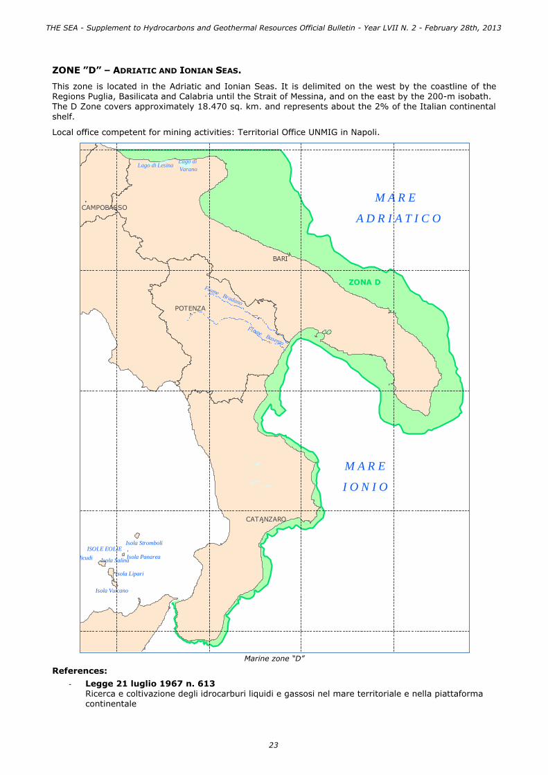
ZONE ”D” – ADRIATIC AND IONIAN SEAS.
This zone is located in the Adriatic and Ionian Seas. It is delimited on the west by the coastline of the Regions Puglia, Basilicata and Calabria until the Strait of Messina, and on the east by the 200-m isobath. The D Zone covers approximately 18.470 sq. km. and represents about the 2% of the Italian continental
shelf.
Local office competent for mining activities: Territorial Office UNMIG in Napoli.
Marine zone “D”
References:
- Legge 21 luglio 1967 n. 613 Ricerca e coltivazione degli idrocarburi liquidi e gassosi nel mare territoriale e nella piattaforma continentale
CAMPOBASSO
POTENZA
BARI
CATANZARO
M O
N T
E N
E G
R O
Isola Alicudi
Isola di Capri
M A R E
I O N I O
M A R E
A D R I A T I C O
ZONA D
Isola Pianosa
ISOLE TREMITI
Isola Salina
ISOLE EOLIEIsola Stromboli
Isola Vulcano
Isola Filicudi Isola Panarea
Isola Lipari
Fiume Bradano
Fiume Basento
Lago di LesinaLago di
Varano
THE SEA - Supplement to Hydrocarbons and Geothermal Resources Official Bulletin - Year LVII N. 2 - February 28th, 2013
23

ZONE “E” – LIGURIAN AND TYRRHENIAN SEAS, SEA OF SARDINIA
This zone is located in the Ligurian and Tyrrhenian Seas and the Sea of Sardinia. It is delimited on the west by the coastline of the Regions Sardinia, Liguria, Toscana, Lazio, Campania, Basilicata, Calabria, until the Strait of Messina, and on the east by the 200-m isobath. On the North of the Sardinian coasts,
in the marine area of Bocche di Bonifacio, it is delimited by the boundary line between Italy and France.
The Law N° 9 of January 9,1991, “Norme per l’attuazione del nuovo Piano energetico nazionale” – established the following areas closed entirely to oil and gas exploration and exploitation: Gulfs of Naples and Salerno. The Zone E covers approximately 39.260 sq. km., and represents about the 7% of the Italian continental shelf. Local offices competent for mining activities: Territorial Office UNMIG in Bologna, Roma and Napoli.
Marine zone “E”
References:
- Legge 21 luglio 1967 n. 613
Ricerca e coltivazione degli idrocarburi liquidi e gassosi nel mare territoriale e nella piattaforma continentale
CATANZARO
BARI
POTENZA
CAMPOBASSO
NAPOLI
L'AQUILA
ANCONA
ROMA
PERUGIA
VENEZIA
BOLOGNA
FIRENZE
MILANO
CAGLIARI
GENOVA
TORINO
PALERMO
F R A
N C
I A
C R O A Z I A
C O R S I C A
ZONA E
ZONA E
ZONA C
Isola Stromboli
Isola Panarea
Isola Lipar i
Isola Vulcano
Isola SalinaIsola Filicudi
Isola Alicudi
Isola di Us tica
Isola di
Levanzo
Isola di
Favignana
ISOLE EGADI
Isola di Marettimo
Isola Pianosa
ISOLE TREMITI
M A R E A D
R I A T I C O
Isola di Procida
Isola d'Ischia
ISOLE PONTINE
Isola di Ventotene
Isola
PalmarolaIsola Zanone
Isola di Ponza
Isola di Capr iM A R E
T I R R E N O
Isola di Montecr is to
Isola del Giglio
Isola d'Elba
ARCIPELAGO
TOSCANO
Isola Pianosa
Isola di Gorgona
Isola di Capraia
ISOLE EOLIE
M A R E
I O N I O
Fiume Base nto
Fiume Brad an o
La g o d i
Va ra n oLa g o d i Lesin a
Fiume Volturno
Fiume Teve re
La g o d i
Bra ccia n o
La g o
Tra simen o
Fium
e T
evere
La g o d i
Bo lsen a
La g o d i
Vico
Valli di
Comacchio
Fi ume P o
Fi ume Adige
Fiume Arno
La g o d i
Ga rd a
Fiume Po
Fiume Po
THE SEA - Supplement to Hydrocarbons and Geothermal Resources Official Bulletin - Year LVII N. 2 - February 28th, 2013
24
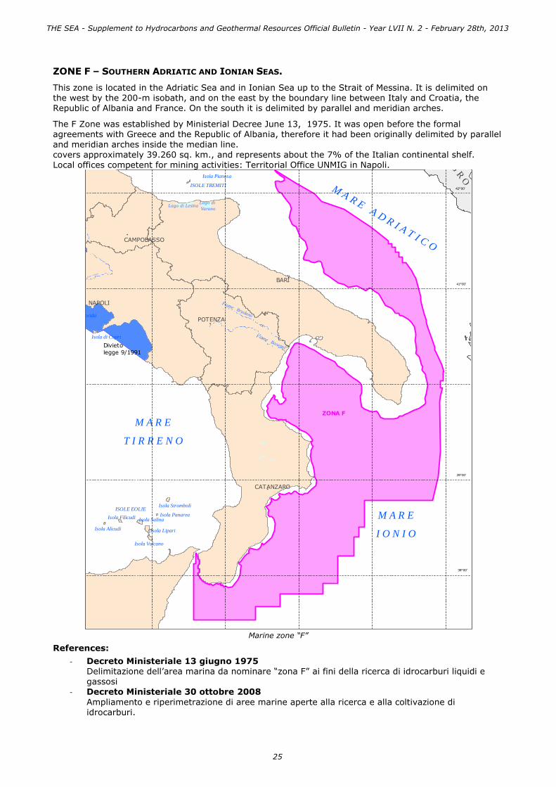
ZONE F – SOUTHERN ADRIATIC AND IONIAN SEAS.
This zone is located in the Adriatic Sea and in Ionian Sea up to the Strait of Messina. It is delimited on the west by the 200-m isobath, and on the east by the boundary line between Italy and Croatia, the Republic of Albania and France. On the south it is delimited by parallel and meridian arches.
The F Zone was established by Ministerial Decree June 13, 1975. It was open before the formal agreements with Greece and the Republic of Albania, therefore it had been originally delimited by parallel and meridian arches inside the median line. covers approximately 39.260 sq. km., and represents about the 7% of the Italian continental shelf. Local offices competent for mining activities: Territorial Office UNMIG in Napoli.
Marine zone “F”
References:
- Decreto Ministeriale 13 giugno 1975 Delimitazione dell’area marina da nominare “zona F” ai fini della ricerca di idrocarburi liquidi e gassosi
- Decreto Ministeriale 30 ottobre 2008
Ampliamento e riperimetrazione di aree marine aperte alla ricerca e alla coltivazione di idrocarburi.
Divieto
legge 9/1991
CATANZARO
POTENZA
NAPOLI
BARI
CAMPOBASSO
M O
N T
E N
E G
R O
A L
B A
N I A
Isola d'Ischia
ZONA F
M A R E
I O N I O
M A R E A D R I A T I C O
ISOLE TREMITI
Isola Pianosa
Isola Stromboli
Isola PanareaIsola Salina
Isola Lipari
Isola Vulcano
M A R E
T I R R E N O
Isola Filicudi
Isola Alicudi
ISOLE EOLIE
Isola di Procida
Isola di Capri
Fi ume Volturno
Fiume Bradano
Fiume Basento
Lago di LesinaLago di
Varano
41°00'
42°00'
39°00'
38°00'
THE SEA - Supplement to Hydrocarbons and Geothermal Resources Official Bulletin - Year LVII N. 2 - February 28th, 2013
25

ZONA “G” – TYRRHENIAN SEA AND SICILY CHANNEL.
It is divided in two sector: the north sector, which extends into the southern Tyrrhenian Sea and the
Sicily Channel, is delimited to the north by arcs of meridian and parallel, to the southwest by the
boundary line ITALY- TUNISIA and to east by the isobath of 200 m.
The southern sector, which extends into the Sicily Channel, has recently been expanded with DM
29/03/2010 and is delimited to the north by the isobath of 200 m, to the west by the boundary line
ITALY- TUNISIA and to the east by the meridian and parallel arcs inside the median line ITALY-MALTA.
With the law 9 January 1991. 9 “Norme per l’attuazione del nuovo Piano energetico nazionale - has been
prohibited prospection, exploration and production of hydrocarbons in the waters of the Egadi islands.
The “G” area covers approximately 36,220 sq. km accounting for approximately 7% of the Italian
continental shelf.
Local offices competent for mining activities: Territorial Office UNMIG in Napoli.
Marine zone “G”
References:
- Decreto Ministeriale 26 giugno 1981
Delimitazione di due aree marine nella piattaforma continentale italiana denominate nel
complesso “zona G” ai fini della ricerca e coltivazione di idrocarburi liquidi e gassosi. - Decreto Ministeriale 30 ottobre 2008
Ampliamento e riperimetrazione di aree marine aperte alla ricerca e alla coltivazione di idrocarburi.
- Decreto Ministeriale 29 marzo 2010 Aree marine aperte alla ricerca e coltivazione di idrocarburi. Ampliamento della “Zona G”.
CAGLIARI
CATANZARO
PALERMO
ISOLA
DI
MALTA
T U N
I S I A
M A R E
I O N I O
Isola Salina
Isola Stromboli
Isola Panarea
Isola Lipari
Isola Vulcano
C A N A L E D I S I C I L I A
Isola Alicudi
ISOLE EOLIE
Isola Filicudi
ZONA G
M A R E T I R R E N O
Isola di Ustica
Isola di Pantelleria
ISOLE PELAGIE
Isola di Lampedusa
Isola di Linosa
Isolotto Lampione
Isola di Levanzo
Isola di Favignana
ZONA G
Isola di Marettimo
ISOLE EGADI
THE SEA - Supplement to Hydrocarbons and Geothermal Resources Official Bulletin - Year LVII N. 2 - February 28th, 2013
26

CRITERIA AND STANDARDS RELATING TO RESTRICTIONS ON MINING ACTIVITIES
Offshore mineral rights for research permits and exploitation concessions are granted by the Ministry of Economic Development, in consultation with the Ministry of the Environment, which issue a specific environmental assessment.
Before the enforcement of specific rules establishing sites declared as off-limits to mineral resource activities, the Ministry of Environment imposed, by Ministerial Decree 28/07/1994, the prohibition on sea dumping of materials resulting from the prospection, exploration and production of oil and gas in sensitive areas, or "in the belt of three nautical miles from the coastline or from the limit of the protected areas as specified in paragraph 1; for the marine nature reserves that limit will be indicated in the decree designing the areas, or in other environmental laws;".
As for the offshore activities of prospection, exploration and production of hydrocarbons, the Law N°
9/1991, as provided in Article 4, prohibits such activities in the waters of the Gulf of Naples and Salerno, the Egadi Islands, and the Gulf of Venice, in the sea area between the parallel lying on the mouth of the River Tagliamento and the Po River Goro branch.
Subsequently, the Law Decree N°112/2008, (art. 8, paragraph 1), ordered that the prohibition in the Gulf of Venice is applied until the Council of Ministers, in agreement with the Veneto Region and on a proposal of the Minister of Environment and Protection of Land and Sea, has verified that non
appreciable risk of subsidence on the coast has occurred.
A new delimitation of interdicted areas to mining activities was introduced by Legislative Decree N° 128/2010, which has extended the prohibition for oil and gas research in offshore areas located within 12 nautical miles from the outer limit of the marine and coastal protected areas, as well
for liquid hydrocarbons in the marine belt within 5 miles from the baselines of the territorial waters along the entire length of coastline. This rule was subsequently modified by the Legislative Decree N° 121/2011, which provides that, for the historic bay of the Gulf of Taranto, the prohibition on liquid hydrocarbons research, is within five
miles from the coastline.
The Decree Law N° 83 of June 22, 2012, -
"Urgent measures for the growth of the Country," has further modified the Article 6, Section 17 of the Environmental Code, establishing the applicability of the prohibition to application after
June 20, 2010 and laying down the mandatory environmental impact assessment and the involvement of local authorities administrating the territory within twelve miles. Finally, the activities referred in Article 1, paragraph 82-sexies of Law n° 239 of August 23, 2004, shall be authorized, in accordance with the environmental
constraints by the local competent offices of the National Mining Office for Hydrocarbons and GeoResouces.
Map of the interdicted areas to mining activities
CATANZARO
BARI
POTENZA
CAMPOBASSO
NAPOLI
PALERMO
TRIESTE
L'AQUILA
ANCONA
ROMA
PERUGIA
VENEZIA
BOLOGNA
FIRENZE
TRENTO
MILANO
CAGLIARI
GENOVA
TORINO
AOSTA
T U
N I S
I A
F R
A N
C I
A
S V I Z Z E R A
A L G E R I A
C O R S I C A
A U S T R I A
ISOLA
DI
MALTA
S L O V E N I A
C R O A
Z I A
B O S N I A
-
E R Z E G O V
I N A
M O
N T E N
E G
R O
A L
B A
N I A
7°00' 8°00' 9°00' 10°00'
8°00' 9°00' 10°00' 11°00'7°00'
13°00'11°00' 12°00' 14°00'
44°00'
41°00'
12°00' 13°00' 14°00'15°00' 16°00'
15°00' 16°00' 17°00' 19°00'18°00'
17°00' 19°00'18°00'
46°00'
45°00'
43°00'
42°00'
39°00'
38°00'
37°00'
35°00'
36°00'
M A R E
T I R R E N O
M A R E A D R I A T I C O
C A N A L E D I S I C I L I A
M A R E
I O N I O
THE SEA - Supplement to Hydrocarbons and Geothermal Resources Official Bulletin - Year LVII N. 2 - February 28th, 2013
27

HYDROCARBON EXPLORATION AND EXPLOITATION OFFSHORE ACTIVITIES
OVERVIEW OF REGIONAL GEOLOGY
GEOLOGICAL EVOLUTION OF THE ITALIAN SEAS
The geologic evolution of the Italian territory and its seas has been particularly complex giving origin therefore to an articulated and heterogeneous structural setting, although little quiet from the tectonic point of view. This did not help the formation of large oil fields but has in fact generated only locally favorable conditions to the formation of some oil provinces of small and medium-size, compared to those of northern Europe and especially American ones.
During the convergence process between plates, Africa is "inserted” in Europe through a wedge poorly deformed, named Adria. This wedge extends from the Ionian Sea to the western part of the Po Valley and is bordered by the Dinaric Alps, the southern Alps and the Apennines. The Adria is a fragment of the great African plate. The breaking zone is the Malta’s escarpment, a kind of submerged wall through which the seafloor is lowered to a depth of several hundred meters in the Sicily channel to a depth of about 4,000 meters in the Ionian abyssal plain. By the collision between Europe and Adria and the deformation of its continental boundaries have originated Alps and Dinarides; other mountain ranges, the Apennines
and the Calabrian arc, have been created along the southwestern edge of the Adriatic promontory during
its collapsing (subduction). The Sicilian northern and inner mountains are originated by the deformation of the African plate; post-collisional basins, with oceanic lithosphere of new generation (western Mediterranean and Tyrrhenian sea), were opened near subduction zones of plates (collapse of the African-Adriatic plate under the Corsica-Sardinia block in the western Mediterranean area, collapse of the Adriatic plate under the Apennines and Calabrian arc in the Tyrrhenian sea); fragments of continental lithosphere (Corsica-Sardinia block, which was originally part of the European plate) are rotated and have
been carried away from the original area.
Cinematic - structural sketch of the central mediterranean. Modified by: CNR - Project on Geodynamics (1990). Structural Model of Italy
1:500.000 and Gravity Map. Quad. Ric. Scient., 3 (114).
The geological phenomena led to the current configuration of the central Mediterranean and the time is measured in millions of years. The "recent geological history" tells us that around 30 million
years ago began the rotation of the Corsica-Sardinia block and the opening of the western Mediterranean, around 8 million years ago began to open the
Tyrrhenian basin behind the Apennines and the Calabrian arc that gradually advanced towards the current Po Valley and to the Adriatic and Ionian seas.
THE SEA - Supplement to Hydrocarbons and Geothermal Resources Official Bulletin - Year LVII N. 2 - February 28th, 2013
28

The distribution of the Italian oil provinces is similar to its geological and structural setting, which certainly affects the amount of reserves. The proof is the comparison between the structural map of our
country and the main oil fields both on land and at sea: in particular, about 40% of them are located in areas of chain (among them the famous ones of the southern Apennines and of the central Sicily) and 60% instead in foredeep and foreland areas.
CNR - Neotectonic sketch map of Italy (Mem. Soc. Geol. , 1996)
From the tectonic – structural point of view, Italy can be divided into four main areas:
1. a "back-arc basin" or a little deformed area represented by the Tyrrhenian sea, which tends to open up towards SE;
2. a '" chain area " from the Apennines to the Alps which continues over Calabria and Sicily; 3. a '"foredeep area" similar to a large basin particularly depressed and geologically little deformed
that we can locate at the front of the chain and is represented by the Adriatic margin, by the Ionian area and the channel of Sicily;
4. an area of "foreland" which can be defined as an area not yet deformed - in particular the Po Valley, the Adriatic sea, south of Sicily and eastern Europe and Sicily channel.
THE SEA - Supplement to Hydrocarbons and Geothermal Resources Official Bulletin - Year LVII N. 2 - February 28th, 2013
29

As a rule, the oil fields of the northern Adriatic and of Po Valley are closed between the Alpine and Apennine fronts which advance towards one each other; the central - southern Adriatic basin is closed
between the Apennines and Dinarides in the east, the Calabria offshore oil fields, south-east Sicily and the Sicily channel.
The most important oil provinces of our country are: the Northern Adriatic and the Po Valley (oil and
gas), the Abruzzi basin and the central Adriatic (oil and gas), the Southern Adriatic Sea (oil and gas), the southern Apennines (oil), Calabria offshore (gas), Iblean offshore and Sicily channel (oil and gas). The offshore natural gas italian fields contain mainly biogenic gas (due to bacterial activity occurred in shallow sediments and consists essentially of pure methane) associated with foredeep plio – quaternary clastic deposits; a less important part contains thermogenic gas (created in very deep sediments, high temperatures conditions and without bacterial activity) often associated with tertiary chain clastic deposits or mesozoic carbonates of chain and foreland.
The oil offshore deposits are generally associated with foreland mesozoic carbonate and more rarely with chain mesozoic carbonate.
Italian oil provinces
Map of licenses for exploration, production and storage of hydrocarbons
THE SEA - Supplement to Hydrocarbons and Geothermal Resources Official Bulletin - Year LVII N. 2 - February 28th, 2013
30

GEOLOGICAL FEATURES
The Italian marine areas are characterized by a stratigraphic - structural setting highly variable. In particular, the geological map at a scale 1:250,000 highlights, through the mapping of one or more significant stratigraphic horizons, the geological general characteristics and the main structural -
stratigraphic characters of our seas.
Adriatic sea
The Adriatic sea is an area of shallow water. Only in the southern area, in front of the coast of Puglia, reaches great depths (about 1,200 m). From the geological point of view the Adriatic sea looks very differentiated: the western part is the Apennines foreland, while the eastern side is the foreland of the Dinaric chain; between these two areas lies the foreland of the two chains, relatively undeformed. The Bouguer anomalies have a minimum near
the Conero area, in continuity with the foredeep of the Po Valley, and another minimum in the Pescara area. Another region with negative gravimetric values is located at east, in the area adjacent to the Albanian coasts. Two maximum are still present in the Gargano and Istria areas. The western part of the north Adriatic area is occupied by the most recent foredeep, originated at the front of the Apennines, and migrated at a later time to the east. In this region, the base of the plio-quaternary sequence is folded with a dip towards the Apennines. The relatively undeformed foreland of
the chains surrounding the Adriatic area emerges in Istria and Puglia. These regions are characterized by modest thickness of the Plio - Quaternary sequence and by vertical tectonics. The available wells in the Adriatic sea allow us to reconstruct its stratigraphic evolution. Below the plio-quaternary sequence has been highlighted the presence of sequences similar to those Umbria-Marche and those sudalpine. Their stratigraphy reflects the tectonic evolution of the Adriatic continental margin from its identification, related to permotriassic rifting and lower jurassic fragmentation, to its involvement in the Apennines structure. A particular event occurs in the Messinian, when a lowering of relative sea
level and hyper-saline conditions, in the entire Mediterranean, produces subaerial erosion and deposition of evaporitic sediments resulting in an well identified seismic horizon. Evaporites and other sediments are deposited during this interval and they are almost uniformly present.
Ionian Sea
The Ionian sea is situated between the Calabrian arc and the Malta escarpment to the west, and the Apulian ridge to the east. It is a deep basin up to 4,000 m which represents the leavings of an old oceanic zone or continental crust very thin originated during extensional phases that led to the opening of
the Tethys.
The Ionian sea is currently involved in a process of consumption as a result of subduction phenomena still active in the central Mediterranean. The Bouguer anomalies are generally increasing from the margins to the central areas of the basin. A different region in gravimetric terms is the Taranto gulf, which is characterized by a gravimetric minimum having NW-SE direction in continuity with the bradanic foredeep.
The Malta escarpment, which forms the western boundary of the basin, has approximately NS direction and length of about 300 km; its identification dates back to the Lias, during the opening of the Tethys, as extensional fault that caused the sinking of the ionic block. In the region of the Taranto gulf, where there are the three elements that characterize the Southern Apennines or rather the chain, the bradanico-ionic foredeep and foreland, there is also an extensional tectonics which occurs through faults oriented NW-SE and NE-SW , with a modest throw in the Apulian platform and a greater throw in the Calabria margin, which are evident in the formation of the graben of
Sybaris.
Sicily cannel
The Sicily channel is a shallow water area situated on the northern edge of the African plate which represents the foreland of the Apennine-Maghrebian chain. In the central part there are few narrow
depressions characterized by high depth. This area is characterized by a gravimetric maximum oriented NW-SE. The Bouguer anomalies also show a region, near the southern coast of Sicily, with negative values as the minimum centered on the foredeep of Caltanissetta.
It shows different geological domains with different setting, including the Gela fold, whose front extends into the sea and represents the outermost structure belonging to the deformation system of Maghrebids-Sicily, the Gela foredeep, the plateau of Malta, where it is found a thickness of about 5,000 m of pre-Pliocene sediments hanging over crystalline rocks of the African basement, the Pantelleria and Linosa rift and the basins of the Egadi islands, which splits the African foreland and are composed of Plio-Pleistocene turbiditic sediments with thicknesses ranging from 1,000 at Pantelleria up to 2,500 m in the basins of the
Egadi.
THE SEA - Supplement to Hydrocarbons and Geothermal Resources Official Bulletin - Year LVII N. 2 - February 28th, 2013
31

Tyrrhenian Sea
The Tyrrhenian is a deep sea; it’s a back-arc basin. It is divided into two areas, north and south, with different structural and geophysical features.
Southern Tyrrhenian sea
It’s a deep basin (3,620 m maximum depth). In the two basinal deep areas, Vavilov and Marsili
basins, there are positive values of Bouguer anomalies. The evolution of the Tyrrhenian basin is contemporary with other important volcanic phenomena in addition to the formation of oceanic crust in the Vavilov and Marsili basins: there is in fact the formation of three volcanic arcs. The oldest in Sardinia, the most recent in the Aeolian Islands and in the adjacent sea volcanoes and an presumed intermediate arc in the central Tyrrhenian. There are also volcanoes, the most important of which are those that make up the submarine relief of Magnaghi of Vavilov and Marsili.
Northern Tyrrhenian sea
The northern Tyrrhenian sea reaches, to the south, the maximum depth of 2,200 m. The Bouguer anomaly is slightly positive and gradually increases towards the south. The ridge of Elba, in NS direction, divides this area into two sectors: the Tuscan margin and the Corsica basin.
Ligurian sea and sea of Sardinia
They are the most eastern part of western Mediterranean and include areas that reach a depth of about
3,000 m. The Bouguer anomalies are strongly positive in the central areas of the basin and decrease rapidly towards the boundary areas.
THE MOST IMPORTANT OFFSHORE DEPOSITS
The seismic profiles, the gravity anomalies, subsidence and tectonic episodes and the exploration wells data have been used to study in detail and describe the stratigraphy and evolution of the Italian seas.
The flexural history is of great meaning with respect to the hydrocarbons generation and accumulation:
about 75% of the Italian biogenic gas is related to Pliocene foredeep series, most of the thermogenic gas is probably issued from Miocene flysch series, and in many oil accumulations the source rock series entered the maturity window during the flexural subsidence.
With particular regard to the Italian petroleum exploration plays, also in relation to their flexural history and sedimentary evolution, we can describe the most interesting at sea.
In the outern margin of Calabria is recognized a terrigenous basin, which extends both to the land and off-shore all along the Ionian coast of Calabria. In particular the LUNA fields, and its satellites, the largest
gas pools outside the Po Valley and the Northern Adriatic, have different producing pools, the most important of which is by far the thermogenic dry gas ones. Issued from an unknown tertiary source the gas migrated and then trapped at the top of a thrust fold, sealed by either marls or clays.
In the Sicily channel some oil fields such NILDE , are located along the tectonically inverted innermost part of the foredeep and the oil is trapped in bioclastic, karstified, limestones of Miocene age. The source rock is uncertain, possibly Mesozoic.
In the central Adriatic some middle-sized fields (SARAGO MARE, EMILIO, S. GIORGIO MARE, DAVID) produce oil and gas from upper Cretaceous-Paleocene resedimented, fractured bioclastic limestones levels, which are intercalated in a dominant pelagic mudstones series. These beds are interpreted to come from a nearby carbonatic shelf margin that have been subsequently eroded.
In the lower Pliocene began one of the most important orogenic phase which involved in particular northern and central Apennines generating a new and large foredeep and originated a new set of some structural and physiographic basins. The most important of these is by far the one that includes such
fields AGOSTINO, PORTO GARIBALDI AND SQUALO CENTRALE. These fields contain biogenic gas accumulated in some levels of turbiditic sands deformed and folded.
During the Pleistocene an important regional relative sea level fall occurred and were deposited large amounts of sand and clay in the Quaternary basins. In the northern Adriatic, in the sandy levels, several biogenic gas pools were found, in anticlines traps; some of these are BARBARA, ADA and BONACCIA.
THE SEA - Supplement to Hydrocarbons and Geothermal Resources Official Bulletin - Year LVII N. 2 - February 28th, 2013
32

Active production facilities in the North Adriatic Sea
However, there are some important petroleum systems which, in relation to their formation and evolution, are not so affected from phenomena related to strong deformation.
Among them are certainly mentioned VEGA, PREZIOSO and PERLA fields in which the Inici formation, consisting essentially of limestone gray-whitish often heavily dolomitized (equivalent to the Syracuse formation in the iblea area), produces heavy oil and is rich in sulfur and are expected that the rock is composed of limestones and shales of the Streppenosa formation.
In the northern part of the Apulian platform is localized the large filed of Rospo Mare. In this area the Apulian platform is constituted by an alternation of dolomite and anhydrite from the late Triassic, thick Jurassic dolomitic series of inner shelf environment, bioclastic clays and shales of the lower Cretaceous.
Seismic sections and wells data show that this sequence changes facies laterally towards mudstone series well stratified and typical of deeper water platform and euxinic environment; during the Cretaceous is certainly occurred an event of emersion of the shelf that was then eroded while the sedimentation continued in submerged areas. A large topographic high zone was so occupied by heavy immature oil,
rich in sulfur, with a cap rock provided by both the Messinian anhydrites and the Pliocene marls. It is in general assumed that the source is the oil prone Upper Triassic Burano Formation or Emma limestones.
In the deep AQUILA oil field the stratigraphic sequence is made up mainly of a thick sequence of sands, clays and marls of pelagic environment aged between Pleistocene and Oligocene, by alternating shales,
mudstones and marls aged between Paleocene and upper Cretaceous, deep water mudstones of Jurassic age and Lower Jurassic shelf margin packstones grainstones and dolomites. The oil column impregnates a
thickness of approximately 130 meters in fractured pelagic limestones series. The structure is an anticline, partly flowed during the faulting of the shelf margin.
PERUGIA
ANCONA
M A R E A D R I A T I C O
A .C 21.A GA .C 30.EA
PO RTO
C O RSINI M .
A .C 27.EA
A .C 4 .A S
C ERV IA
MA REFA SC IA
C ERV IA M .
A .C 5 .A V
A .C 6 .A S
A .C 24.EA A .C 8 .ME
A .C 17.A G
A .C 32.A G
A .C 12.A G
A .C 13.A S
A .C 11.A G
A .C 7 .A S
B.C 22.A G
B.C 14.A SB.C 13.A S
B.C 17.TO
B.C 10.A S
B.C 21.A G
B.C 3 .A S
B.C 7 .LF
B.C 12.A S
B.C 4.AS
B.C 15.A V
B.C 2 .LF
B.C 20.A S
MA RIA A MA RE
RUBIC O NE
GRO TTA MMA RE
SA N GIO RGIO
MA RE C ENTRA LE
FA NO
FA LC O NA RA
A NTA RES
MO RENA
GIULIA
REGINA DA RIA
ELEO NO RA
FA BRIZIA
JO LE
ELENA
SA RA GO MA RE
NA IDE
PO RTO C O RSINI MA RE
C ERV IA A RIA NNA
A NEMO NE
A NTO NELLA
A ZA LEABA SIL
A NNA BELLA
A NNA LISA
BRENDA
A NNA MA RIA
BA RBA RA
C A LPURNIAC LA RA
C LA RA O V EST
C A LIPSO
C LA RA EST
BO NA C C IA
C A MILLA
PENNINA
EMILIO
V O NGO LA MA RE
DA V ID
SA N GIO RGIO MA RE
A .C 18.A G
A .C 28.EA
B.C 11.A S
B.C 18.RI
BA RBA RA T2
THE SEA - Supplement to Hydrocarbons and Geothermal Resources Official Bulletin - Year LVII N. 2 - February 28th, 2013
33

THE MOST SIGNIFICANT STAGES OF EXPLORATION IN THE ITALIAN SEAS
Despite the complexity of geological settings, Italy has begun to take an interest in offshore hydrocarbon exploration since the 1950, when the research carried out by Agip, expanding to the south of the Po Valley, came to Ravenna and in 1953, still on land, however, it obtained his first great success with the
discovery of the gas field of the same name.
However, there were already all the conditions so that the rich gas fields discovered in the Po Valley could continue in Adriatic offshore; in those years were developing technologies for exploration, drilling and development in offshore.
The reasonable assurance that the Adriatic sea was a rich gas province pushed Agip to make the first marine seismic survey in Italy in the mid-fifties. At the same time it was made another seismic survey in Gela offshore area to study and verify the extension in the sea of the oil field discovered on land in 1957.
In 1959 was drilled the well Gela 21, oil bearing, which is recognized as the first offshore well drilled in western Europe. Followed, immediately after, the Ravenna 1 well in the Adriatic sea.
More and important gas discoveries were made in the Ravenna offshore, in particular Ravenna Mare south, Cervia Mare, Porto Garibaldi, Porto Corsini and, in the central Adriatic, the S. Stefano Mare field.
In the Calabria offshore, between the late 60’s and early 70’s was discovered the Luna gas field, in the
waters of Crotone.
Also in the central Adriatic in the mid-70’s there was the discovery the Rospo Mare field and in 1982 was drilled the horizontal well Rospo Mare 6dir.
In the early 90’s was drilled by Agip the first well in waters deeper than 800 meters discovering the Aquila oil field, offshore the coast of Puglia.
In the marine area C between 1970 and 1980 were discovered the deposits of Nilde, Mila, Perla and Vega.
In the early months of 2000 took place the discoveries of Panda, Argo and Cassiopea reservoirs.
At present, also due to the opening and extension of some marine areas, are studied very deep water over 1,000 meters in both the Ionian sea and in the Sicily channel.
THE SEA - Supplement to Hydrocarbons and Geothermal Resources Official Bulletin - Year LVII N. 2 - February 28th, 2013
34

MINING LICENSES
Over the last years it has been consolidating the trend started in the second half of the 90’s of the decrising of the number of mining licenses and the total area they occupy. While in the early 90’s were
active over 80 offshore exploration permits on December 31st 2012 there are 25 exploration permits active for a total occupied area of 7.252 km2. The number of exploitation concession, instead, remained costant; on December 31st 2012 there are 67 concessions active for a total occupied area of 8.949 km2. It should be noted that the area of mining licenses is defined according to criteria established by the current law and regulation and generally it has an extention of few squared kilometers. It constitutes the
esclusive area in which it can operate only the authorized operator and it results much larger than the effective area occupied by the plants that commonly need just a few acres. The areas related to mining licenses are therefore not affected by the activities of exploration and production except small portions, subjected to specific authorizations, in which the plants are made. In order to make clear the impact of activities compared to the overall area of the licenses, maps of mining licenses and plants have been developed and published on the website in the section "Cartography"
where, with regional details, there are reported respectively, the licenses held by the permit holders and
dealers and the location of plants in the area.
EXPLORATION PERMITS
YEARS 2001-2012
Number Km2 Zone A Zone B Zone C Zone D Zone E Zone F Zone G Total
2001 45 19.719 16 11 3 2 0 11 2 45
2002 40 18.818 14 6 3 2 0 11 4 40
2003 34 15.996 13 5 2 0 0 10 4 34
2004 27 11.502 11 4 4 0 1 3 4 27
2005 30 11.726 11 6 3 0 1 2 7 30
2006 29 11.343 10 6 3 0 1 2 7 29
2007 32 14.654 10 5 3 0 1 3 10 32
2008 27 12.825 7 4 3 0 1 3 9 27
2009 24 11.006 7 3 3 0 0 2 9 24
2010 24 11.006 7 3 3 0 0 2 9 24
2011 25 11.689 7 3 3 0 1 2 9 25
2012 25 7.252 8 5 4 2 1 2 3 25
Number of exploration permits divided in year and marine zones
THE SEA - Supplement to Hydrocarbons and Geothermal Resources Official Bulletin - Year LVII N. 2 - February 28th, 2013
35

Number and extension of exploration permits at sea in the last years 2001-2012
Number of exploration permits at sea in the last years 2001-2012 divided in marine zones
0
5.000
10.000
15.000
20.000
25.000
0
5
10
15
20
25
30
35
40
45
50
2001 2002 2003 2004 2005 2006 2007 2008 2009 2010 2011 2012
Number
km2
0
5
10
15
20
25
30
35
40
45
50
2001 2002 2003 2004 2005 2006 2007 2008 2009 2010 2011 2012
Zone G
Zone F
Zone E
Zone D
Zone C
Zone B
Zone A
THE SEA - Supplement to Hydrocarbons and Geothermal Resources Official Bulletin - Year LVII N. 2 - February 28th, 2013
36

EXPLOITATION CONCESSIONS
YEARS 2001-2012
Number Km2 Zone A Zone B Zone C Zone D Zone F Total
2001 69 9.638 36 21 5 5 2 69
2002 69 9.665 36 21 5 5 2 69
2003 69 9.672 36 21 5 5 2 69
2004 69 9.604 36 21 5 5 2 69
2005 66 9.283 36 20 4 4 2 66
2006 67 9.430 37 20 4 3 3 67
2007 66 9.373 37 19 4 3 3 66
2008 66 9.373 37 19 4 3 3 66
2009 65 8.864 37 19 3 3 3 65
2010 65 8.864 37 19 3 3 3 65
2011 66 8.940 38 19 3 3 3 66
2012 67 8.940 38 19 3 4 3 67
Number of exploitation concessions divided in year and marine zone
THE SEA - Supplement to Hydrocarbons and Geothermal Resources Official Bulletin - Year LVII N. 2 - February 28th, 2013
37

Number and extension of exploitation concession at sea in the last years
Number of exploitation concessions at sea in the last years 2001-2012 divided in marine zones
8.400
8.600
8.800
9.000
9.200
9.400
9.600
9.800
63
64
65
66
67
68
69
70
2001 2002 2003 2004 2005 2006 2007 2008 2009 2010 2011 2012
Number
km2
0
10
20
30
40
50
60
70
80
2001 2002 2003 2004 2005 2006 2007 2008 2009 2010 2011 2012
Zona F
Zona D
Zona C
Zona B
Zona A
THE SEA - Supplement to Hydrocarbons and Geothermal Resources Official Bulletin - Year LVII N. 2 - February 28th, 2013
38

Into the north Adriatic sea there is an area in which the activities of prospecting, of exploration and of production of hydrocarbons are prohibited. This area is subject to the establishment of the non-existence
of appreciable risk of subsidence on the coast in accordance with Legislative Decree 25 June 2008, n. 112. The mineral licenses already granted and active at the time of entry into force of Decree Law 112/2008 are currently suspended.
The prohibition of hydrocarbons prospecting, exploration and production will remain applied until the Council of Ministers, with the agreement of the Veneto region, on the proposal of the Minister of Environment and Protection of Land and Sea, would definitively find the non-existence of appreciable risk of subsidence on the coast.
Prohibited area to the mining activities in the North Adriatic Sea
THE SEA - Supplement to Hydrocarbons and Geothermal Resources Official Bulletin - Year LVII N. 2 - February 28th, 2013
39

MAP OF ACTIVE MINING LICENSES AT SEA
Data as December 31st, 2012
CATANZARO
BARI
POTENZA
CAMPOBASSO
NAPOLI
PALERMO
TRIESTE
L'AQUILA
ANCONA
ROMA
PERUGIA
VENEZIA
BOLOGNA
FIRENZE
TRENTO
MILANO
CAGLIARI
GENOVA
TORINO
AOSTA
Iso la d ell'Asin a ra
Iso la d i Bu d elli
Iso la d i Ca p ra ia
Iso la d i Ca p rera
Iso la d ella M a d d a len a
Iso la d i Ta vo la ra
Iso la d i M o la ra
Iso la d i Go rg o n a
Iso la d i Pia n o sa
Iso la d i M o n tecristo
Iso la d 'Elb a
ARCIPELAGO
TOS CANO
Iso la d el Gig lio
Iso la d i
S . Pietro
Iso la d i
S . An tio co
Iso la d i S erp en ta ra
C A N A L E D I S I C I L I A
Iso la d i Pa n telleria
Iso la d i M a rettimo
M A R E
T I R R E N O
IS OLE EGADI
Iso la d i Leva n zo
La mp io n e
Iso la d i
Fa vig n a n a
Iso la d i Ustica
Iso la d i La mp ed u sa
IS OLE
PELAGIE
Iso la d i L in o sa
Iso la d i Filicu d i
Iso la d i Alicu d i
IS OLE EOLIE
Iso la d i L ip a ri
Iso la d i S a lin a
Iso la
Pa lma ro laIso la d i Po n za
Iso la Za n o n e
IS OLE PONTINE
Iso la d i Ven to ten e
Iso la d ' Isch ia
Iso la d i Pro cid a
Iso la d i Ca p ri
Iso la d i Pa n a rea
Iso la d i S tro mb o li
Iso la d i Vu lca n o
GOLFO DI
S QUILLACE
M A R E
I O N I O
IS OLE TREM ITI
Iso la d i S a n Do min oIso la d i Ca p ra ra
GOLFO DI
POLICASTRO
Iso la d i Pia n o sa
GOLFO
DI
TARANTO
M A R E A D R I A T I C O
T U
N I S
I A
F R
A N
C I
A
S V I Z Z E R A
A L G E R I A
C O R S I C A
A U S T R I A
ISOLA
DI
MALTA
S L O V E N I A
C R O A
Z I A
B O S N I A
-
E R Z E G O V
I N A
M O
N T
E N E
G R
O
THE SEA - Supplement to Hydrocarbons and Geothermal Resources Official Bulletin - Year LVII N. 2 - February 28th, 2013
40

DRILLING ACTIVITIES
HISTORICAL DATA
The exploration of new reservoir in the sea has had its greatest period of expansion in the early 90's with an average of approximately 80 new wells drilled per year of which a large part of was exploratory. From the second half of the 90’s the number of new drilling at sea has been gradually declined, and in the last decade there has been a progressive decrease in the research of new deposits.
The activities of the operators is almost exclusively oriented to the optimization and development of known fields rather than the research of new resources. In particular, from 2008 to 2012, were carried out on average 15-20 new wells per year, none of which was exploratory. From the point of view of the
findings the last decade was not encouraging with only 11 exploration of successful gas wells and the only "Ombrina Mare 2 dir" successful oil well.
Year Number of well drilled Meters drilled
Exploration Development TOTAL Exploration Development TOTAL
1991 26 54 80 52.094 187.105 239.199
1992 15 73 88 39.718 222.934 262.652
1993 6 21 27 10.123 37.414 47.537
1994 10 46 56 23.467 128.733 152.200
1995 8 10 18 14.793 26.375 41.168
1996 10 27 37 27.550 87.911 115.461
1997 11 10 21 30.266 29.285 59.551
1998 9 17 26 18.794 41.448 60.242
1999 6 12 18 12.374 28.086 40.460
2000 6 19 25 19.065 27.058 46.123
2001 2 15 17 2.325 39.086 41.411
2002 5 7 12 11.200 19.699 30.899
2003 5 21 26 8.658 28.380 37.038
2004 0 22 22 0 41.189 41.189
2005 0 24 24 0 49.399 49.399
2006 3 17 20 9.139 29.714 38.853
2007 1 15 16 3.517 33.027 36.544
2008 3 7 10 6.673 14.330 21.003
2009 0 20 20 0 37.770 37.770
2010 0 17 17 0 23.568 23.568
2011 0 22 22 0 31.621 31.621
2012 0 15 15 0 24.561 24.561
THE SEA - Supplement to Hydrocarbons and Geothermal Resources Official Bulletin - Year LVII N. 2 - February 28th, 2013
41

Number of wells drilled at sea in the years 1991-2012
Meters drilled at sea in the years 1991-2012
0
10
20
30
40
50
60
70
80
90
100
19
91
19
92
19
93
19
94
19
95
19
96
19
97
19
98
19
99
20
00
20
01
20
02
20
03
20
04
20
05
20
06
20
07
20
08
20
09
20
10
20
11
20
12
Development
Exploration
0
50.000
100.000
150.000
200.000
250.000
300.000
19
91
19
92
19
93
19
94
19
95
19
96
19
97
19
98
19
99
20
00
20
01
20
02
20
03
20
04
20
05
20
06
20
07
20
08
20
09
20
10
20
11
20
12
Development
Exploration
THE SEA - Supplement to Hydrocarbons and Geothermal Resources Official Bulletin - Year LVII N. 2 - February 28th, 2013
42

NEW RESOURCES AT SEA IN THE YEARS 2002-2012
Year Zone A Zone B Zone G
2002 CALIPSO 003 DIR A CALIPSO 004 DIR A DIDONE 002
PANDA 001
2003 ANNAMARIA 002 ARMIDA 001 DIR A
PANDA OVEST 001
2006 BENEDETTA 001 DIR ARGO 001
2008 OMBRINA MARE 002 DIR CASSIOPEA 001 DIR ARGO 002
DRILLING ACTIVITIES AT SEA IN THE YEAR 2012
During the year 2012 the drilling activities at sea has concerned 15 positions, for a total of 24,561 meters drilled. Of these four drilling activities are related to development activities and the remaining 11 are work over of existing wells. During the year it has not been made any new exploratory well.
WELLS DRILLED DURING THE YEAR 2012
Well name aim Meters drilled in the year
1. ANTONELLA 006 DIR B Development 3.313
2. BARBARA E 044 DIR B Workover 761
3. BARBARA E 053 DIR A Workover 1.401
4. BARBARA E 055 DIR B Workover 1.405
5. BARBARA E 048 DIR B Workover 1.048
6. BARBARA E 051 DIR A Workover 1.270
7. BASIL 006 DIR C Workover 1.205
8. BASIL 009 DIR A Workover 828
9. BRENDA 002 DIR A Workover 1.949
10. BRENDA 006 DIR A Workover 1.387
11. BRENDA 003 DIR A Workover 1.910
12. BRENDA 004 DIR A (*) Workover 893
13. NAOMI 002 DIR A Development 1.862
14. PANDORA 002 DIR Development 2.131
15. PORTO CORSINI MARE OVEST C 026 DIR B Development 3.198
(*) Not already completed at the date of 31/12/2012
Three wells drilled in the year 2011 have been completed during the year 2012
Well name completion aim Result
1. CLARA NORD 007 DIR A 18/01/2012 Workover Gas
2. DARIA 005 DIR A 15/01/2012 Workover Gas
3. LUNA 041 DIR A 08/01/2012 Workover Gas
THE SEA - Supplement to Hydrocarbons and Geothermal Resources Official Bulletin - Year LVII N. 2 - February 28th, 2013
43

VIDEPI PROJECT –
PUBLICATION OF THE DATA RELATED TO THE HYDROCARBON EXPLORATION IN ITALY
The ViDEPI project aims to make easily accessible technical documents relating to the hydrocarbon
exploration in Italy.
This documentation is concerning ceased mining licenses, and therefore public, filed since 1957 at the UNMIG (National Mineral Office for Hydrocarbon and Geothermal Resources) of the Ministry of Economic Development.
The current legislation establishes that Companies operating in individual mining license must provide to UNMIG progressive technical reports on its activity in the same licenses including copies of example documents such as geological maps, structural maps, profiles end of wells, seismic lines, etc..
The same law provides that the documents submitted become public available after one year from termination of the license for which they were produced.
In more than half a century has come to be an important basis of data relating to Italian underground.
Before the implementation of the ViDEPI project, the entire documentation was available only printed and
difficult to use because classified only according to the criteria of the mining license in which they had been acquired and deposited in the UNMIG Offices.
The project, proposed and directed by the Italian Geological Society, was made possible due to the
Ministry of Economic Development, which provided the basis of data and by Assomineraria (Association of oil companies operating in Italy), which has funded it. All paper documentation retrieved and processed, has been entrusted to the Library of scientific technological area of Roma Tre University (BAST), according to the agreements reached with the Ministry of Economic
Development, where it is available to consultation.
All dataset have been digitalized and published on the website at link: http://www.videpi.com
PRODUCTION ACTIVITIES
HISTORICAL DATA
The National gas production in the year 2012 was of 8.540 Million of Scm of which 6.074 were
produced from offshore reservoir (71%). The oil offshore production is less and in the 2012, compared
with a national production of 5,37 millions of tons, only 0,47 million of tons (9%) were produced at sea.
THE SEA - Supplement to Hydrocarbons and Geothermal Resources Official Bulletin - Year LVII N. 2 - February 28th, 2013
44

NATURAL GAS PRODUCTION DIVIDED IN ZONES (Million of Scm) - YEARS 1992-2012
Zone A Zone B Zone C
Zone D
Zone F
Total
1992 9.899 1.502 15 1.937 103 13.457
1993 10.030 2.479 15 2.069 70 14.663
1994 11.265 2.210 11 2.520 61 16.067
1995 11.720 1.831 11 2.494 48 16.104
1996 11.663 2.056 8 2.396 20 16.144
1997 11.716 1.602 6 2.227 0 15.552
1998 11.965 1.422 6 2.072 72 15.538
1999 10.651 1.641 6 1.905 89 14.292
2000 9.541 1.755 6 1.735 68 13.104
2001 8.434 2.479 4 1.639 55 12.611
2002 7.916 2.513 5 1.587 369 12.390
2003 7.372 2.286 4 1.621 37 11.320
2004 6.878 2.079 5 1.545 32 10.539
2005 6.358 1.738 4 1.428 15 9.543
2006 5.907 1.324 5 1.252 7 8.494
2007 5.163 1.083 4 1.016 0 7.267
2008 4.700 1.234 4 877 0 6.815
2009 3.939 1.084 4 892 0 5.919
2010 4.230 979 5 896 0 6.110
2011 4.055 1.089 5 849 0 5.997
2012 4.086 1.153 4 830 0 6.074
Gas offshore production divided in zones (millions of tons) – Years 1992-2012
0
2.000
4.000
6.000
8.000
10.000
12.000
14.000
16.000
18.000
ZF
ZD
ZC
ZB
ZA
THE SEA - Supplement to Hydrocarbons and Geothermal Resources Official Bulletin - Year LVII N. 2 - February 28th, 2013
45
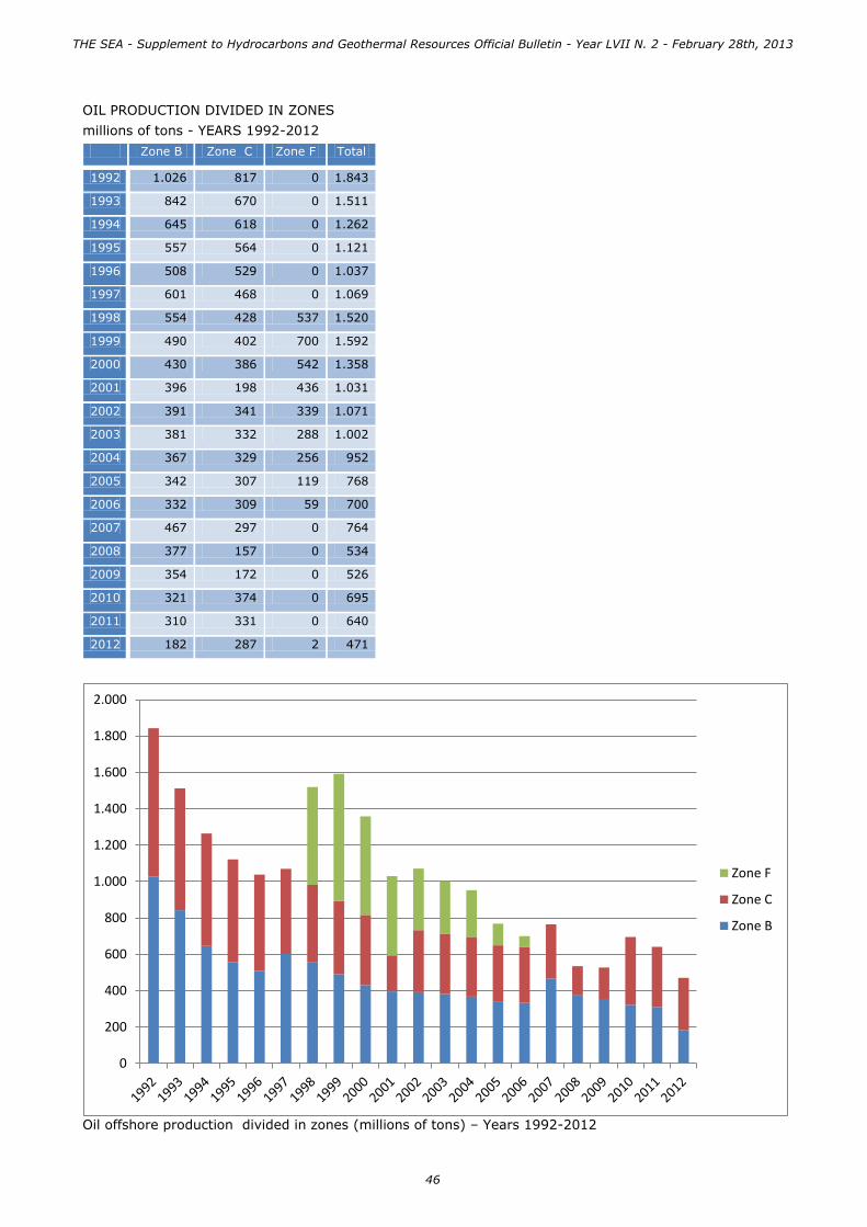
OIL PRODUCTION DIVIDED IN ZONES
millions of tons - YEARS 1992-2012
Zone B Zone C Zone F Total
1992 1.026 817 0 1.843
1993 842 670 0 1.511
1994 645 618 0 1.262
1995 557 564 0 1.121
1996 508 529 0 1.037
1997 601 468 0 1.069
1998 554 428 537 1.520
1999 490 402 700 1.592
2000 430 386 542 1.358
2001 396 198 436 1.031
2002 391 341 339 1.071
2003 381 332 288 1.002
2004 367 329 256 952
2005 342 307 119 768
2006 332 309 59 700
2007 467 297 0 764
2008 377 157 0 534
2009 354 172 0 526
2010 321 374 0 695
2011 310 331 0 640
2012 182 287 2 471
Oil offshore production divided in zones (millions of tons) – Years 1992-2012
0
200
400
600
800
1.000
1.200
1.400
1.600
1.800
2.000
Zone F
Zone C
Zone B
THE SEA - Supplement to Hydrocarbons and Geothermal Resources Official Bulletin - Year LVII N. 2 - February 28th, 2013
46

HYDROCARBON PRODUCTION AND CONSUMPTION RATIO (toe)
Consumption [toe]
National Production
[toe]
% of production on National consumption
Production from offshore fields
[toe]
% of offshore production on national
consumption
GAS 63,81 7,00 11,0% 4,98 7,8%
Oil 69,16 5,37 7,8% 0,47 0,7%
Total 132,97 12,37 9,3% 5,45 4,1%
In the absence of 2012 data it is shown the consumption of hydrocarbon of the year 2011 1,000 cubic meters of gas = 0.82 toe (tons of equivalent oil)
PRODUCING WELLS
In the Italian offshore on December 31st 2012 there were 722 operating wells of which 396 in production (335 gas producing and 61 oil producing), 312 potentially productive but not delivering, and 14 used for monitoring and other purposes. The 335 gas producing wells are located in Area A (252) in Area B (55)
and in Area D (28). The production of crude oil is limited to the area B (31 wells) and to the area C (30).
OPERATING WELLS IN THE ITALIAN OFFSHORE ON DECEMBER 31, 2012
Zone A Zone B Zone C Zone D Zone F Zone G Total
Producing 252 86 30 28 0 0 396
Potentially productive 227 63 14 1 3 4 312
Other use 13 1 0 0 0 0 14
Total 492 150 44 29 3 4 722
Number of offshore producing wells on December 31, 2012 divided in marine zones
252
86
30
28
Zone A
Zone B
Zone C
Zone D
THE SEA - Supplement to Hydrocarbons and Geothermal Resources Official Bulletin - Year LVII N. 2 - February 28th, 2013
47

OFFSHORE PRODUCING WELLS DIVIDED IN MINERAL PRODUCTION AND IN MARINE ZONES
Zone A Zone B Zone C Zone D Total
Natural gas 252 55 0 28 335
Crude Oil 0 31 30 0 61
Total 252 86 30 28 396
Producing wells divided in mineral production and marine zones
252
55
28 31 30
0
50
100
150
200
250
300
Zone A Zone B Zone C Zone D
Natural gas
Crude oil
THE SEA - Supplement to Hydrocarbons and Geothermal Resources Official Bulletin - Year LVII N. 2 - February 28th, 2013
48

GATHERING AND TREATMENT CENTERS
The production of natural gas from offshore hydrocarbon reservoirs is directed by pipeline to the 10 centers of gathering and treatment as reported in the following schedule.
Center Name Provincia Operator Linked platform Zone n. linked wells
n. producing
wells
1 CASALBORSETTI
Ravenna Eni 1. AGOSTINO A 2. AGOSTINO A CLUSTER 3. AGOSTINO B 4. AGOSTINO C 5. GARIBALDI A 6. GARIBALDI A CLUSTER 7. GARIBALDI B 8. GARIBALDI C 9. GARIBALDI D 10. NAOMI PANDORA 11. PORTO CORSINI M W A 12. PORTO CORSINI M W B 13. PORTO CORSINI M W C
Zone A 147 63
2 RAVENNA MARE Ravenna Eni 1. AMELIA A 2. AMELIA B 3. AMELIA C 4. AMELIA D 5. ANGELA ANGELINA 6. ANGELA CLUSTER 7. ANTARES 8. ANTARES 1 9. ARMIDA 10. ARMIDA 1 11. DIANA 12. GUENDALINA 13. PORTO CORSINI 80 14. PORTO CORSINI 80 BIS 15. PORTO CORSINI M E C 16. PORTO CORSINI M S 1 17. PORTO CORSINI M S 2 18. TEA
Zone A 130 42
3 RUBICONE Forlì-Cesena
Eni 1. ANEMONE B 2. ANEMONE CLUSTER 3. ANTONELLA 4. ARIANNA A 5. ARIANNA A CLUSTER 6. AZALEA A CLUSTER 7. AZALEA B 8. CERVIA A 9. CERVIA A CLUSTER 10. CERVIA B 11. CERVIA C 12. MORENA 1 13. NAIDE
Zone A 74 40
4 FANO Pesaro e Urbino
Eni 1. ANNABELLA 2. ANNALISA 3. ANNAMARIA B 4. BASIL 5. BRENDA 6. DARIA A 7. REGINA 8. REGINA 1
Zone A 53 42
THE SEA - Supplement to Hydrocarbons and Geothermal Resources Official Bulletin - Year LVII N. 2 - February 28th, 2013
49
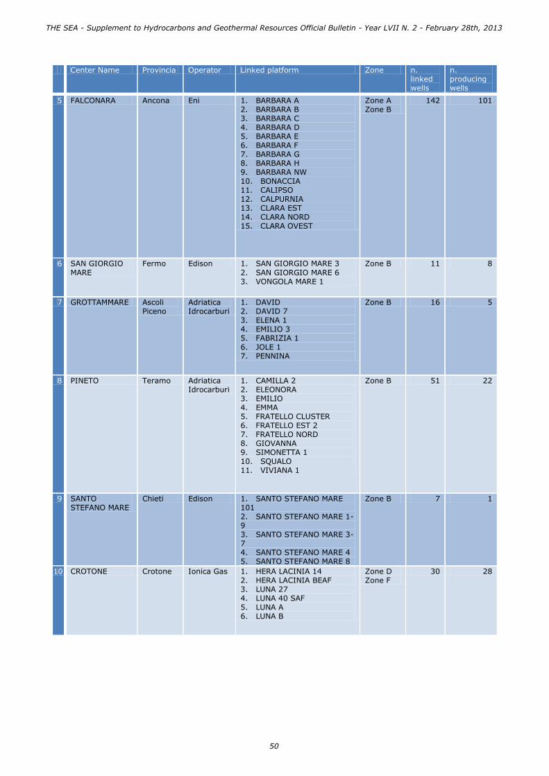
Center Name Provincia Operator Linked platform Zone n. linked wells
n. producing wells
5 FALCONARA Ancona Eni 1. BARBARA A 2. BARBARA B 3. BARBARA C 4. BARBARA D 5. BARBARA E 6. BARBARA F 7. BARBARA G 8. BARBARA H 9. BARBARA NW 10. BONACCIA 11. CALIPSO 12. CALPURNIA 13. CLARA EST 14. CLARA NORD 15. CLARA OVEST
Zone A Zone B
142 101
6 SAN GIORGIO
MARE
Fermo Edison 1. SAN GIORGIO MARE 3
2. SAN GIORGIO MARE 6 3. VONGOLA MARE 1
Zone B 11 8
7 GROTTAMMARE Ascoli Piceno
Adriatica Idrocarburi
1. DAVID 2. DAVID 7 3. ELENA 1 4. EMILIO 3 5. FABRIZIA 1 6. JOLE 1 7. PENNINA
Zone B 16 5
8 PINETO Teramo Adriatica Idrocarburi
1. CAMILLA 2 2. ELEONORA 3. EMILIO 4. EMMA 5. FRATELLO CLUSTER 6. FRATELLO EST 2 7. FRATELLO NORD 8. GIOVANNA 9. SIMONETTA 1 10. SQUALO 11. VIVIANA 1
Zone B 51 22
9 SANTO STEFANO MARE
Chieti Edison 1. SANTO STEFANO MARE 101 2. SANTO STEFANO MARE 1-9 3. SANTO STEFANO MARE 3-7 4. SANTO STEFANO MARE 4 5. SANTO STEFANO MARE 8
Zone B 7 1
10 CROTONE Crotone Ionica Gas 1. HERA LACINIA 14 2. HERA LACINIA BEAF 3. LUNA 27 4. LUNA 40 SAF 5. LUNA A 6. LUNA B
Zone D Zone F
30 28
THE SEA - Supplement to Hydrocarbons and Geothermal Resources Official Bulletin - Year LVII N. 2 - February 28th, 2013
50
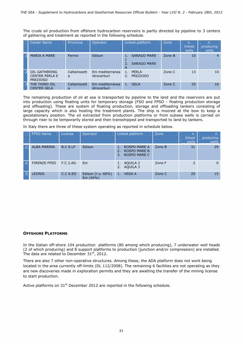
The crude oil production from offshore hydrocarbon reservoirs is partly directed by pipeline to 3 centers of gathering and treatment as reported in the following schedule.
Center Name Provincia Operator Linked platform Zone n. linked
wells
n. producing
wells
1 MARIA A MARE Fermo Edison 1. SARAGO MARE 1 2. SARAGO MARE A
Zone B 10 4
2 OIL GATHERING CENTER PERLA E PREZIOSO
Caltanissetta
Eni mediterranea idrocarburi
1. PERLA 2. PREZIOSO
Zone C 13 10
3 THE THIRD OIL CENTER GELA
Caltanissetta
Eni mediterranea idrocarburi
1. GELA Zone C 25 16
The remaining production of oil at sea is transported by pipeline to the land and the reservoirs are put into production using floating units for temporary storage (FSO and FPSO - floating production storage
and offloading). These are system of floating production, storage and offloading tankers consisting of large capacity which is also hosting the treatment plants. The ship is moored at the bow to keep a
geostationary position. The oil extracted from production platforms or from subsea wells is carried on through riser to be temporarily stored and then transshipped and transported to land by tankers.
In Italy there are three of these system operating as reported in schedule below.
FPSO Name License Operator Linked platform Zone n. linked wells
n. producing
wells
1 ALBA MARINA B.C 8.LF Edison 1. ROSPO MARE A 2. ROSPO MARE B 3. ROSPO MARE C
Zone B 31 29
2 FIRENZE FPSO F.C 2.AG Eni 1. AQUILA 2 2. AQUILA 3
Zone F 2 0
3 LEONIS C.C 6.EO Edison (r.u. 60%) Eni (40%)
1. VEGA A Zone C 20 15
OFFSHORE PLATFORMS
In the Italian off-shore 104 production platforms (80 among which producing), 7 underwater well heads (2 of which producing) and 8 support platforms to production (junction and/or compression) are installed. The data are related to December 31st, 2012.
There are also 7 other non-operative structures. Among these, the ADA platform does not work being
located in the area currently off-limits (DL 112/2008). The remaining 6 facilities are not operating as they
are new discoveries made in exploration permits and they are awaiting the transfer of the mining license
to start production.
Active platforms on 31st December 2012 are reported in the following schedule.
THE SEA - Supplement to Hydrocarbons and Geothermal Resources Official Bulletin - Year LVII N. 2 - February 28th, 2013
51

EXPLOITATION PLATFORMS
Platform Name n. pro-ducing wells
Zone Min Type of platform Center
1 AGOSTINO A 4 ZA Gas struttura reticolare 8 gambe CASALBORSETTI
2 AGOSTINO A CLUSTER 2 ZA Gas cluster CASALBORSETTI
3 AGOSTINO B 8 ZA Gas struttura reticolare 8 gambe CASALBORSETTI
4 AGOSTINO C 3 ZA Gas struttura reticolare 8 gambe CASALBORSETTI
5 AMELIA A 2 ZA Gas struttura reticolare 8 gambe RAVENNA MARE
6 AMELIA B 0 ZA Gas struttura reticolare 8 gambe RAVENNA MARE
7 AMELIA C 1 ZA Gas struttura reticolare 4 gambe RAVENNA MARE
8 AMELIA D 4 ZA Gas struttura reticolare 4 gambe RAVENNA MARE
9 ANEMONE B 4 ZA Gas struttura reticolare 4 gambe RUBICONE
10 ANEMONE CLUSTER 3 ZA Gas cluster RUBICONE
11 ANGELA ANGELINA 10 ZA Gas struttura reticolare 8 gambe RAVENNA MARE
12 ANGELA CLUSTER 1 ZA Gas cluster RAVENNA MARE
13 ANNABELLA 5 ZA Gas struttura reticolare 8 gambe FANO
14 ANNALISA 4 ZA Gas struttura reticolare 4 gambe FANO
15 ANNAMARIA B 6 ZA Gas struttura reticolare 4 gambe FANO
16 ANTARES 4 ZA Gas struttura reticolare 6 gambe RAVENNA MARE
17 ANTARES 1 0 ZA Gas monotubolare RAVENNA MARE
18 ANTONELLA 5 ZA Gas struttura reticolare 8 gambe RUBICONE
19 ARIANNA A 6 ZA Gas struttura reticolare 6 gambe RUBICONE
20 ARIANNA A CLUSTER 3 ZA Gas cluster RUBICONE
21 ARMIDA 5 ZA Gas struttura reticolare 6 gambe RAVENNA MARE
22 ARMIDA 1 0 ZA Gas monotubolare RAVENNA MARE
23 AZALEA A CLUSTER 0 ZA Gas cluster RUBICONE
24 AZALEA B 2 ZA Gas struttura reticolare 4 gambe RUBICONE
25 BARBARA A 6 ZA Gas struttura reticolare 4 gambe FALCONARA
26 BARBARA B 1 ZA Gas struttura reticolare 4 gambe FALCONARA
27 BARBARA C 6 ZA Gas struttura reticolare 8 gambe FALCONARA
28 BARBARA D 14 ZA Gas struttura reticolare 8 gambe FALCONARA
29 BARBARA E 12 ZA Gas struttura reticolare 8 gambe FALCONARA
30 BARBARA F 15 ZA Gas struttura reticolare 8 gambe FALCONARA
31 BARBARA G 12 ZA Gas struttura reticolare 8 gambe FALCONARA
32 BARBARA H 5 ZA Gas struttura reticolare 8 gambe FALCONARA
33 BARBARA NW 6 ZA Gas struttura reticolare 4 gambe FALCONARA
34 BASIL 7 ZA Gas struttura reticolare 4 gambe FANO
35 BONACCIA 10 ZB Gas struttura reticolare 4 gambe FALCONARA
36 BRENDA 2 ZA Gas struttura reticolare 4 gambe FANO
37 CALIPSO 2 ZB Gas struttura reticolare 4 gambe FALCONARA
38 CALPURNIA 4 ZB Gas struttura reticolare 4 gambe FALCONARA
39 CERVIA A 3 ZA Gas struttura reticolare 8 gambe RUBICONE
40 CERVIA A CLUSTER 1 ZA Gas cluster RUBICONE
41 CERVIA B 5 ZA Gas struttura reticolare 6 gambe RUBICONE
42 CERVIA C 6 ZA Gas struttura reticolare 8 gambe RUBICONE
43 CLARA EST 3 ZB Gas struttura reticolare 4 gambe FALCONARA
44 CLARA NORD 4 ZB Gas struttura reticolare 4 gambe FALCONARA
45 CLARA OVEST 1 ZB Gas struttura reticolare 8 gambe FALCONARA
46 DARIA A 13 ZA Gas struttura reticolare 4 gambe FANO
47 DAVID 1 ZB Gas monotubolare GROTTAMMARE
48 DAVID 7 2 ZB Gas monotubolare GROTTAMMARE
49 DIANA 0 ZA Gas cluster RAVENNA MARE
50 ELEONORA 0 ZB Gas struttura reticolare 8 gambe PINETO
51 EMILIO 1 ZB Gas struttura reticolare 4 gambe PINETO
52 EMMA 8 ZB Gas struttura reticolare 4 gambe PINETO
53 FABRIZIA 1 0 ZB Gas monotubolare GROTTAMMARE
54 FRATELLO CLUSTER 2 ZB Gas cluster PINETO
55 FRATELLO EST 2 1 ZB Gas monotubolare PINETO
56 FRATELLO NORD 2 ZB Gas bitubolare PINETO
57 GARIBALDI A 6 ZA Gas struttura reticolare 8 gambe CASALBORSETTI
58 GARIBALDI A CLUSTER 1 ZA Gas cluster CASALBORSETTI
59 GARIBALDI B 10 ZA Gas struttura reticolare 8 gambe CASALBORSETTI
60 GARIBALDI C 4 ZA Gas struttura reticolare 8 gambe CASALBORSETTI
THE SEA - Supplement to Hydrocarbons and Geothermal Resources Official Bulletin - Year LVII N. 2 - February 28th, 2013
52

Platform Name n. pro-
ducing wells
Zone Min Type of platform Center
61 GARIBALDI D 6 ZA Gas struttura reticolare 8 gambe CASALBORSETTI
62 GELA 5 ZC Olio pontile NUOVO CENTRO OLIO GELA
63 GIOVANNA 4 ZB Gas struttura reticolare 8 gambe PINETO
64 GIULIA 1 0 ZA Gas monotubolare FANO
65 GUENDALINA 2 ZA Gas monotubolare RAVENNA MARE
66 HERA LACINIA 14 1 ZD Gas monotubolare CROTONE
67 HERA LACINIA BEAF 3 ZD Gas struttura reticolare 4 gambe CROTONE
68 JOLE 1 1 ZB Gas monotubolare GROTTAMMARE
69 LUNA A 11 ZD Gas struttura reticolare 8 gambe CROTONE
70 LUNA B 12 ZD Gas struttura reticolare 8 gambe CROTONE
71 MORENA 1 0 ZA Gas monotubolare RUBICONE
72 NAIDE 2 ZA Gas bitubolare RUBICONE
73 NAOMI PANDORA 1 ZA Gas struttura reticolare 4 gambe CASALBORSETTI
74 PENNINA 1 ZB Gas struttura reticolare 8 gambe GROTTAMMARE
75 PERLA 4 ZC Olio struttura reticolare 4 gambe CENTRO RACCOLTA OLIO PERLA E PREZIOSO
76 PORTO CORSINI 80 0 ZA Gas struttura reticolare 8 gambe RAVENNA MARE
77 PORTO CORSINI 80 BIS 0 ZA Gas struttura reticolare 8 gambe RAVENNA MARE
78 PORTO CORSINI M E C 7 ZA Gas struttura reticolare 8 gambe RAVENNA MARE
79 PORTO CORSINI M S 1 1 ZA Gas monotubolare RAVENNA MARE
80 PORTO CORSINI M S 2 1 ZA Gas monotubolare RAVENNA MARE
81 PORTO CORSINI M W A 0 ZA Gas struttura reticolare 12 gambe
CASALBORSETTI
82 PORTO CORSINI M W B 0 ZA Gas struttura reticolare 12 gambe
CASALBORSETTI
83 PORTO CORSINI M W C 6 ZA Gas struttura reticolare 8 gambe CASALBORSETTI
84 PREZIOSO 6 ZC Olio struttura reticolare 8 gambe CENTRO RACCOLTA OLIO PERLA E PREZIOSO
85 REGINA 5 ZA Gas struttura reticolare 4 gambe FANO
86 REGINA 1 0 ZA Gas monotubolare FANO
87 ROSPO MARE A 9 ZB Olio struttura reticolare 4 gambe ALBA MARINA
88 ROSPO MARE B 12 ZB Olio struttura reticolare 8 gambe ALBA MARINA
89 ROSPO MARE C 8 ZB Olio struttura reticolare 4 gambe ALBA MARINA
90 SAN GIORGIO MARE 3 0 ZB Gas struttura reticolare 4 gambe SAN GIORGIO MARE
91 SAN GIORGIO MARE 6 1 ZB Gas struttura reticolare 4 gambe SAN GIORGIO MARE
92 SANTO STEFANO MARE
101
0 ZB Gas struttura reticolare 4 gambe SANTO STEFANO
MARE
93 SANTO STEFANO MARE 1-9
1 ZB Gas struttura reticolare 5 gambe SANTO STEFANO MARE
94 SANTO STEFANO MARE 3-7
0 ZB Gas struttura reticolare 4 gambe SANTO STEFANO MARE
95 SANTO STEFANO MARE 4 0 ZB Gas struttura reticolare 4 gambe SANTO STEFANO MARE
96 SANTO STEFANO MARE 8 0 ZB Gas monotubolare SANTO STEFANO MARE
97 SARAGO MARE 1 1 ZB Olio struttura reticolare 4 gambe MARIA MARE
98 SARAGO MARE A 1 ZB Olio struttura reticolare 8 gambe MARIA MARE
99 SIMONETTA 1 1 ZB Gas monotubolare PINETO
100 SQUALO 2 ZB Gas struttura reticolare 4 gambe PINETO
101 TEA 4 ZA Gas struttura reticolare 4 gambe RAVENNA MARE
102 VEGA A 15 ZC Olio struttura reticolare 8 gambe LEONIS
103 VIVIANA 1 0 ZB Gas monotubolare PINETO
104 VONGOLA MARE 1 1 ZB Gas struttura reticolare 4 gambe SAN GIORGIO MARE
THE SEA - Supplement to Hydrocarbons and Geothermal Resources Official Bulletin - Year LVII N. 2 - February 28th, 2013
53

UNDERWATER WELL HEADS
Nome piattaforma Zona Minerale Tipo di piattaforma Centrale Produttiva
1 AQUILA 2 ZF Olio testa pozzo sottomarina FIRENZE FPSO
2 AQUILA 3 ZF Olio testa pozzo sottomarina FIRENZE FPSO
3 CAMILLA 2 ZB Gas testa pozzo sottomarina PINETO Sì
4 ELENA 1 ZB Gas testa pozzo sottomarina GROTTAMMARE
5 EMILIO 3 ZB Gas testa pozzo sottomarina GROTTAMMARE
6 LUNA 27 ZF Gas testa pozzo sottomarina CROTONE
7 LUNA 40 SAF ZD Gas testa pozzo sottomarina CROTONE Sì
EXPLOITATION SUPPORT PLATFORMS
Nome piattaforma Zona Minerale Tipo di piattaforma Centrale
1 BARBARA T ZA GAS struttura reticolare 4 gambe FALCONARA
2 BARBARA T2 ZA GAS struttura reticolare 4 gambe FALCONARA
3 CERVIA K ZA GAS struttura reticolare 4 gambe RUBICONE
4 DARIA B ZA GAS struttura reticolare 4 gambe FANO
5 GARIBALDI K ZA GAS struttura reticolare 4 gambe CASALBORSETTI
6 GARIBALDI T ZA GAS struttura reticolare 4 gambe CASALBORSETTI
7 PORTO CORSINI M W T ZA GAS struttura reticolare 4 gambe CASALBORSETTI
8 SAN GIORGIO MARE CENTRALE
ZB GAS struttura reticolare 4 gambe SAN GIORGIO MARE
NON OPERATING PLATFORMS
Nome piattaforma Zona Minerale Tipo di piattaforma Collegamento a centrale
1 ADA ZA Gas monotubolare
2 ARGO 2 ZG Gas testa pozzo sottomarina
3 BENEDETTA 1 ZA Gas monotubolare RUBICONE
4 CASSIOPEA 1 ZG Gas testa pozzo sottomarina
5 OMBRINA MARE 2 ZB Olio monotubolare
6 PANDA 1 ZG Gas testa pozzo sottomarina
7 PANDA W 1 ZG Gas testa pozzo sottomarina
THE SEA - Supplement to Hydrocarbons and Geothermal Resources Official Bulletin - Year LVII N. 2 - February 28th, 2013
54

NATIONAL ENERGY STRATEGY (SEN)
THE GOALS AND PRIORITIES OF ACTION
Reduce energy costs, achieve and exceed the environmental targets established by the European Union, continue to improve our security of supply and industrial development in the energy sector: these are the objectives of the National Energy Strategy document, designed over two decades by last National Energy Plan.
In the upstream sector, Italy has substantial proven reserves of oil and gas, the largest in Europe after the nordic countries.
In particular, using the latest data available on 31.12.2011, about 60% of gas reserves are located in
marine areas (specifically in zone A) and right by the sea comes up to 70% of Italian production (zones A and B).
According to the objectives of the National Energy Strategy, the proposal is to increase output by 2020, to return essentially to the levels of the 1990s. We expect to produce a further 24 million boe/year (barrels of oil equivalent) of gas, and 57 of additional oil, increasing their contribution to the total energy demand from 7% to 14%. This will allow to mobilize investments and create additional employment, with
an annual saving in energy expenditure of about €5 billion.
The achievement of projects related to mining activities, however, require a commitment of the government to not pursue development in sensitive areas at sea or on land, placing the maximum attention to environmental issues and meet the highest international standards in terms of safety. All the efforts of the country should in fact be oriented towards the sustainable development of domestic hydrocarbons production.
Coherently with these necessities, the new National Energy Strategy focuses on four main goals:
1. significantly reduce the energy cost gap for consumers and businesses, by bringing prices and costs in line with European levels;
2. achieve and exceed the environmental targets established by the European Union’s 2020 Climate and Energy Package;
3. continue to improve our security of supply, especially in the gas sector, and reduce dependency on imports;
4. foster sustainable economic growth by developing the energy sector.
Over the medium-long term, i.e. up to 2020, the main timeframe for the document, in order to attain these results the strategy has been broken down into seven priorities, each with its specific supporting measures that have already been set in motion or are currently being defined, including the "sustainable development of domestic hydrocarbons".
It will be necessary to enact legislation or regulations, to guarantee compliance with the highest international standards for the safety of mining activities and environmental protection also simplifying the authorization process, and initiatives to support the industrial sector and encourage the further
development of technological “hubs”.
In particular those of regulatory actions that affect the offshore sector are intended to:
• strengthen the safety measures governing operations, particularly by implementing offshore safety measures envisaged by the proposed European Regulation;
• bring the procedures for issuing permits into line with European standards, particularly those envisaged by the European Parliament’s recent proposal, adopting a model for issuing one single
permit for both exploration and production, and setting a deadline to submit an expression of interest or an opinion;
• develop production, particularly of natural gas – notwithstanding the offshore protection restrictions in the Environment Code (recently updated by the law decree of 22 June 2012, n. 83 converted with amendments by Law 7 August 2012, n. 134) – while keeping safety margins at levels equal to or higher than those of other EU countries and maintaining the current security and environmental and landscape protection constraints.
Offshore activities were heavily influenced by the prohibitions introduced by Legislative Decree 128/2010 (known as the “environmental corrective”) that banned such activities in many areas and really blocked most offshore R&D work and led to the cancellation of projects worth €3.5 billion.
THE SEA - Supplement to Hydrocarbons and Geothermal Resources Official Bulletin - Year LVII N. 2 - February 28th, 2013
55

With regard to safety offshore activities and in comparison with the European performance in terms of blow-out registered, Italy is in a position of absolute excellence, as shown by the statistics, and in fact
between 2000 and 2010, 230 wells were drilled by Italian operators in domestic waters with 0 blow-out and 817 wells in the world with a single blow-out (Temsah NW), or with an index of 1.22 per 1000 wells. The European operators instead have attained an index of 1,88 per 1000 wells drilled in offshore areas.
Furthermore, the data collected during the drilling and production activities carried out in Italy, both onshore and offshore, underline a reduction of accidents respectively of 74% and of 78% in 2011 if compared with 1995 data. With particular reference to offshore activities is evident that our reservoirs are widely known and characterized by low temperatures and pressures.
The National Energy Strategy mentions, between the five areas in Italy that offer a high potential for development, the Northern Adriatic area and the Sicily channel in which we intend to develop new and more offshore sustainable activities.
THE SEA - Supplement to Hydrocarbons and Geothermal Resources Official Bulletin - Year LVII N. 2 - February 28th, 2013
56

SAFETY AND ENVIRONMENTAL PROTECTION IN OFFSHORE ACTIVITIES
About the issues related to the health and safety of workers and the environmental preservation and
protection, the Ministry of Economic Development plays a key role, because it technically and economically evaluates through its central and local bodies projects, releases the related authorizations, ensures the proper execution of work and the compliance with the workplace safety standards in the entire field of hydrocarbons prospection, exploration and production, including offshore activities.
A GLOBAL OVERVIEW
The United Nations Environment Programme (UNEP) has been the first world organization to deal with
the marine water protection, launching the Regional Seas Programme (RSP) in 1974. It aims to establish a common global strategy and a framework for the environmental protection, promoting the sustainable development and giving, however, an implementation at a “regional” level, following the identification of 18 different macro areas.
The RSPs carry out their functions by an Action Plan (AP). In most cases, the Action Plan is supported by
a strong legal framework through a "regional convention" and associated protocols on the specific issues.
A CONTINENTAL OVERVIEW
EU CONTEXT
Is well-known how the Union's policy has always been aimed to reduce the occurrence of major accidents related to offshore oil and gas activities and to limit their consequences, thus increasing protection of the marine environment and coastal economies against pollution as well as limiting possible interruption to local energy production in the Union and improving the response mechanisms
in case of accident.
As a result, the EU regulatory framework became highly wide, relying on a number of directives of great importance such as:
- Directive 92/91/EC concerning the minimum requirements for improving the safety and health protection of workers in the mineral-extracting industries through drilling (Health and Safety workers Directive);
- Directive 96/61/EC of 24 September 1996 concerning integrated pollution prevention and control;
- Directive 2000/60/EC establishing a framework for EU common action about water policies.
REGIONAL CONTEXT: FOCUS ON THE MEDITERRANEAN SEA
In reference to the mentioned RSP, 16 Mediterranean countries and the European Community adopted the Mediterranean Action Plan (MAP). The MAP was the first ever plan adopted as a regional program under the cover of UNEP, reflecting the great attention demonstrated by the countries overlooking the Mediterranean Sea on the environmental protection.
In particular, we note the Convention for Protection against Pollution in the Mediterranean Sea (Barcelona Convention) as a legal and operating instrument of the MAP with the coastal Countries of both sides of the basin, both EU and extra EU, as signatories.
In accordance with the mentioned Barcelona Convention, about the offshore issues and with specific reference to environmental aspects, we mention the “Protocol for the Protection of the Mediterranean
Sea against pollution resulting from exploration and exploitation of the continental shelf and the
seabed and its subsoil” (Offshore Protocol), entered into force on March 25, 2011.
A NATIONAL OVERVIEW
Italy accurately transposed into its national legislation the EU decisions, adopting so strict and advanced standards that it has been repeatedly used as a reference at EU level; in particular we refer to:
- President of the Republic Decree 24 May 1979, n. 886 "Integration and adaptation of police regulations in mines and quarries”;
- Legislative Decree 25 November 1996, n. 624, as transposition of Directive 92/91/EEC;
THE SEA - Supplement to Hydrocarbons and Geothermal Resources Official Bulletin - Year LVII N. 2 - February 28th, 2013
57

- Legislative Decree 3 April 2006, n. 152 "Environmental Regulations" and subsequent amendments.
Italy is also a signatory to the mentioned Offshore Protocol.
“AFTER MACONDO”:
PROPOSAL FOR AN OFFSHORE REGULATION, EUOAG AND ADHESION TO THE OFFSHORE PROTOCOL
he European Commission reacted to the disaster in the Gulf of Mexico, occurred to the installation well known as “Macondo” in April 2010, through an in-depht analysis of existing standards adopted throughout the European Union.
The study resulted in the drafting of the document “Facing the challenge of the safety of offshore oil and gas activities” (European Commission, 2010), where it is reported that, even though the Union already has examples of excellence in national regulatory practices related to offshore oil and gas activities, an
upward harmonization of the actual regulatory framework for offshore oil and gas operations could further improve the safety of offshore activities. On the basis of these findings, on October 27, 2011, the European Commission adopted the draft "Proposal for a Regulation of the European Parliament and of the Council on safety of offshore oil and gas prospection, exploration and production activities" (Offshore Regulation), with the aim to reduce the
occurrence of major accidents related to offshore oil and gas activities and to limit their consequences,
thus increasing the protection of the marine environment.
Currently (February 2013), the text is being examined by the European Parliament, European Commission and Council of Europe and will almost certainly be adopted during the first half of 2013 in the form of the Directive. The Directorate General is actively involved in the work by formulating observations and proposals aimed at increasing the European safety standards. In particular, the Italian proposal to include in the text tools such as the "black box", already introduced in our system as a result of technical analysis following the accident in the Gulf of Mexico, has been accepted, and so it will be part
of the safety policy of all Member States.
At the same time, it is recognized that the regular exchange of experience between regulators and industry and the shared identification of best practices, as well as the improvement of the implementation measures, are the fundamental aspects of an effective regulatory regime.
In this regard, with European Commission Decision of 19 January 2012, the EU Offshore Authorities Group (EUOAG) was established and it is composed of experts appointed by the competent authorities of the Member States for regulatory oversight in the offshore hydrocarbons and related policies.
Italy plays a key role in this group since its establishment, participating with two representatives appointed by the Ministry of Economic Development and actively participating in working groups because of its relevant experience in the field of hydrocarbons exploration and production, acquired in over fifty years of offshore activities.
Moreover, European Union recently adopted the Offshore Protocol with European Commission Decision of 17 December 2012. It has, therefore, positively evaluated the benefic synergy, coming out from a
possible combined action between the coming in force of Offshore Regulation and Offshore Protocol, since the first is mainly aimed to ensure "the safety of offshore oil and gas", while the second to the "protection against pollution from offshore activities".
THE SEA - Supplement to Hydrocarbons and Geothermal Resources Official Bulletin - Year LVII N. 2 - February 28th, 2013
58

LEGAL FRAMEWORK
INTRODUCTION
The Italian offshore activities’ laws concerns offshore area’s definition, permitting and licensing, safety and environmental protection. The General Directorate follow the impact of laws modification on offshore activities and licensing procedure. In accordance with the primary laws, the directorate adapt the ministry decrees about oil and gas production (Minister Decree, Directorate Decree, circular, bulletin). If is not necessary, the Directorate enforce the new laws.
MAIN LAW ABOUT CONTINENTAL SHELF
- Legge 8 dicembre 1961, n. 1658 – “Adesione alla Convenzione sul mare territoriale e la zona contigua e alla Convenzione sull'alto mare, adottate a Ginevra il 29 aprile 1958 e loro esecuzione”
- Legge 21 luglio 1967, n. 613 – “Ricerca e coltivazione degli idrocarburi liquidi e gassosi nel mare territoriale e nella piattaforma continentale e modificazioni alla L. 11 gennaio 1957, n.6,
sulla ricerca e coltivazione degli idrocarburi liquidi e gassosi”
- Decreto del Presidente della Repubblica 26 aprile 1977, n. 816 – “Norme regolamentari relative all'applicazione della legge 8 dicembre 1961, n. 1658, con la quale è stata autorizzata l'adesione alla convenzione sul mare territoriale e la zona contigua, adottata a Ginevra il 29 aprile 1958, ed è stata data esecuzione alla medesima”
- Legge 2 dicembre 1994, n. 689 – “Ratifica ed esecuzione della Convenzione delle Nazioni Unite sul diritto del mare, con allegati e atto finale, fatta a Montego Bay il 10 dicembre 1982,
nonché dell'accordo di applicazione della parte XI della convenzione stessa, con allegati, fatto a New York il 29 luglio 1994”
AGREEMENTS WITH RIPARIAN COUNTRIES
- Decreto del Presidente della Repubblica 22 maggio 1969 n. 830 - “Accordo tra la
Repubblica italiana e la Repubblica socialista federativa di Jugoslavia”
- Legge 14 marzo 1977 n. 73 - “Ratifica ed esecuzione del trattato tra la Repubblica italiana e la Repubblica socialista federativa di Jugoslavia “
- Legge 3 giugno 1978 n. 347 – “Ratifica ed esecuzione dell'accordo tra la Repubblica italiana e la Repubblica tunisina “
- Legge 23 maggio 1980 n. 290 – “Ratifica ed esecuzione dell'accordo tra la Repubblica italiana e la Repubblica di Grecia”
- Legge 12 aprile 1995 n. 147 – “Ratifica ed esecuzione dell'accordo tra la Repubblica italiana e la Repubblica di Albania”
- Legge 3 giugno 1978 n. 348 – “Ratifica ed esecuzione dell'accordo tra l'Italia e la Spagna relativo alla delimitazione della piattaforma continentale tra i due Paesi, con allegati, firmato a Madrid il 19 febbraio 1974”
- Convenzione Italo-Francese 28 novembre 1986 – “Convenzione tra il Governo della Repubblica Italiana e il Governo della Repubblica Francese relativa alla delimitazione delle
frontiere marittime nell'area delle Bocche di Bonifacio”
MAIN LAWS ABOUT MARINE ZONES OF OFFSHORE ACTIVITIES
- Legge 21 luglio 1967, n. 613 – “Ricerca e coltivazione degli idrocarburi liquidi e gassosi nel mare territoriale e nella piattaforma continentale e modificazioni alla Legge 11 gennaio 1957, n. 6, sulla ricerca e coltivazione degli idrocarburi liquidi e gassosi”
- Decreto Ministeriale 13 giugno 1975 – “Delimitazione dell'area marina da nominare "zona F" ai fini della ricerca di idrocarburi liquidi e gassosi”
- Decreto Interministeriale 26 giugno 1981 – “Delimitazione di due aree marine della piattaforma continentale italiana denominate nel complesso "zona G" ai fini della ricerca e coltivazione di idrocarburi liquidi e gassosi”
- Decreto Ministeriale 30 ottobre 2008 – “Ampliamento e riperimetrazione di aree marine
aperte alla ricerca e alla coltivazione di idrocarburi”
- Decreto Ministeriale 29 marzo 2010 – “Aree marine aperte alla ricerca e alla coltivazione di idrocarburi. Ampliamento della “Zona G”.
THE SEA - Supplement to Hydrocarbons and Geothermal Resources Official Bulletin - Year LVII N. 2 - February 28th, 2013
59

- Decreto Ministeriale 27 dicembre 2012 – “Aree marine aperte alla ricerca e alla coltivazione di idrocarburi. Ampliamento della "Zona C".”
MAIN PROCEDURAL LAWS ABOUT MINING ACTIVITIES
- Legge 21 luglio 1967, n. 613 – “Ricerca e coltivazione degli idrocarburi liquidi e gassosi nel mare territoriale e nella piattaforma continentale e modificazioni alla Legge 11 gennaio 1957, N.6, sulla ricerca e coltivazione degli idrocarburi liquidi e gassosi”
- Legge 9 gennaio 1991, n. 9 – “Norme per l'attuazione del nuovo piano energetico nazionale: aspetti istituzionali, centrali idroelettriche ed elettrodotti, idrocarburi e geotermia, autoproduzioni e disposizioni fiscali”
- Decreto Legislativo 25 novembre 1996, n. 625 – “Attuazione della direttiva 94/22/CEE
relativa alle condizioni di rilascio e di esercizio delle autorizzazioni alla prospezione, ricerca e coltivazione di idrocarburi”
- Legge 31 luglio 2002, n. 179 – “Disposizioni in materia ambientale”
- Legge 23 agosto 2004, n. 239 – “Riordino del settore energetico, nonché delega al Governo per il riassetto delle disposizioni vigenti in materia di energia” - Come modificata ed integrata dalla Legge 23 luglio 2009, n. 99 e dal Decreto Legge 22 giugno 2012, n. 83 convertito con
modificazioni dalla Legge 7 agosto 2012, n. 134.
- Decreto Legislativo 3 aprile 2006 n. 152 – “Norme in materia ambientale” - Come modificato ed integrato dal Decreto Legislativo 29 giugno 2010, n. 128, dal Decreto Legislativo 7 luglio 2011, n. 121, dal Decreto Legge 9 febbraio 2012, n. 5 convertito con modificazioni dalla Legge 4 aprile 2012, n. 35 e dal Decreto Legge 22 giugno 2012, n. 83 convertito con modificazioni dalla Legge 7 agosto 2012, n. 134.
- Circolare Ministeriale del 17/10/2012 - “Modalità di applicazione dell’articolo 1, comma 82-
sexies, della Legge 23 agosto 2004, n.239 introdotto dall’articolo 27, comma 34, della Legge 23 luglio 2009 n.99 e dal comma 1 dell’articolo 35 del Decreto Legge 22 giugno 2012, n. 83 convertito con modificazioni della legge 7 agosto 2012 n. 134“, emessa dalla Direzione, fornisce direttive in materia di procedure da seguire per il rilascio delle autorizzazioni per la realizzazione delle attività finalizzate a migliorare le prestazioni degli impianti di coltivazione di idrocarburi, compresa la perforazione, se effettuate a partire da opere esistenti (Art. 1, comma 82-sexies, della L. 23 agosto 2004,n. 239) e per le successive verifiche del rispetto dei limiti emissivi e di
produzione già approvati.
- Decreto legge 18 ottobre 2012, n 179, art. 34, comma 19 - “Per la piena attuazione dei
piani e dei programmi relativi allo sviluppo e alla sicurezza dei sistemi energetici di cui al Decreto Legislativo 1° giugno 2011, n. 93, gli impianti attualmente in funzione di cui all'articolo 46 del Decreto Legge 1° ottobre 2007, n. 159, convertito, con modificazioni, dalla Legge 29 novembre 2007, n. 222, e di cui agli articoli 6 e 9 della Legge 9 gennaio 1991, n. 9, continuano ad essere
eserciti fino al completamento delle procedure autorizzative in corso previste sulla base dell'originario titolo abilitativo, la cui scadenza deve intendersi a tal fine automaticamente prorogata fino all'anzidetto completamento”.
MAIN REGULATIONS ON SAFETY AND ENVIRONMENTAL PROTECTION
- Legge 9 gennaio 1991, n. 9 – “Norme per l’attuazione del nuovo Piano energetico nazionale.”.
Articolo 4. Divieto di prospezione, ricerca e coltivazione. La prospezione, la ricerca e la coltivazione di idrocarburi è vietata nelle acque del Golfo di Napoli, del Golfo di Salerno e delle Isole Egadi, fatti salvi i permessi, le autorizzazioni e le concessioni in atto, nonchè nelle acque del Golfo di Venezia, nel tratto di mare compreso tra il parallelo passante per la foce del fiume Tagliamento e il parallelo passante per la foce del ramo di Goro del fiume Po.
- Decreto del Ministero dell’Ambiente 28 luglio 1994, art. 1, comma 9 – “Determinazione
delle attività istruttorie per il rilascio dell’autorizzazione allo scarico in mare dei materiali derivanti da attività di prospezione, ricerca e coltivazione di giacimenti idrocarburi liquidi e gassosi”. 9.Scarico in aree protette e sensibili. Fermo restando quanto previsto dall’art. 4 della legge 9 gennaio 1991, n. 9, non possono essere rilasciate nuove autorizzazioni agli scarichi ricadenti nelle aree protette o sensibili così come di seguito definite. Le aree protette sono: - aree archeologiche marine di cui alla legge 1° giugno 1939, n. 1089 e all’art. 1 della legge 8
agosto 1985, n. 431; - zone marine di tutela biologica di cui al decreto del Presidente della Repubblica 2 ottobre
1968, n. 1639, di attuazione della legge 14 luglio 1965, n. 963;
THE SEA - Supplement to Hydrocarbons and Geothermal Resources Official Bulletin - Year LVII N. 2 - February 28th, 2013
60

- zone marine di ripopolamento di cui all’art. 17 della legge 17 febbraio 1982, n. 41; - zone marine e costiere elencate all’art. 31 della legge 31 dicembre 1982, n. 979, così come
perimetrale, in via provvisoria, dall’allegato alla circolare n. 2 del 31 gennaio 1987 del Ministro della marina mercantile nonché quelle istituite ai sensi dell’art. 18 della legge 6 dicembre 1991, n. 394;
- aree protette territoriali costiere (parchi e riserve naturali, nazionali e regionali) individuate o istituite in forza della legge 6 dicembre 1991, n. 394, ovvero da leggi statali o regionali o comunque vincolate da altri provvedimenti amministrativi attuativi.
Le aree sensibili sono: - la fascia delle 3 miglia marine dalla linea di costa o dal limite delle aree protette indicate nel
comma 1; per le riserve naturali marine tale limite sarà quello definitivo indicato nel decreto istitutivo o da eventuali provvedimenti di salvaguardia;
- praterie di fanerogame marine, ovunque ubicate. Per le sole aree sensibili eventuali deroghe in caso di giacimenti aventi particolare rilevanza per l’economia del Paese, potranno essere concesse dal Ministero dell’ambiente, sentito il Ministero dell’industria, del commercio e dell’artigianato.
- Decreto Legge 25 giugno 2008, n. 112 – “Disposizioni urgenti per lo sviluppo economico, la semplificazione, la competitività, la stabilizzazione della finanza pubblica e la perequazione
tributaria”. Convertito con modificazioni dalla Legge 6 agosto 2008, n. 133
Articolo 8. Legge obiettivo per lo sfruttamento di giacimenti di idrocarburi
Il divieto di prospezione, ricerca e coltivazione di idrocarburi nelle acque del golfo di Venezia, di cui all'articolo della legge 9 gennaio 1991, n. 9, come modificata dall'articolo 26 della legge 31 luglio 2002, n. 179, si applica fino a quando il Consiglio dei Ministri, (d'intesa con la regione Veneto), su proposta del (Ministro dell'ambiente e della tutela) del territorio e del mare, non abbia definitivamente accertato la non sussistenza di rischi apprezzabili di subsidenza sulle coste,
sulla base di nuovi e aggiornati studi, che dovranno essere presentati dai titolari di permessi di ricerca e delle concessioni di coltivazione, utilizzando i metodi di valutazione piu' conservativi e prevedendo l'uso delle migliori tecnologie disponibili per la coltivazione.
- Decreto legislativo 20 giugno 2010, n. 128 – “Modifiche ed integrazioni al d.lgs. 03/04/2006, n. 152, recante norme in materia ambientale, a norma dell'articolo 12 della legge 18 giugno 2009, n. 69”.
L’articolo 2, comma 3, lett. h) aggiunge il seguente comma 17 all'articolo 6 del Decreto legislativo
3 aprile 2006, n. 152
17. Ai fini di tutela dell'ambiente e dell'ecosistema, all'interno del perimetro delle aree marine e costiere a qualsiasi titolo protette per scopi di tutela ambientale, in virtù di leggi nazionali, regionali o in attuazione di atti e convenzioni internazionali sono vietate le attività di ricerca, di prospezione nonché di coltivazione di idrocarburi liquidi e gassosi in mare, di cui agli articoli 4, 6 e 9 della Legge 9 gennaio 1991, n. 9.
Il divieto e' altresì stabilito nelle zone di mare poste entro dodici miglia marine dal perimetro esterno delle suddette aree marine e costiere protette, oltre che per i soli idrocarburi liquidi nella fascia marina compresa entro cinque miglia dalle linee di base delle acque territoriali lungo l'intero perimetro costiero nazionale.
- Decreto Legislativo 7 luglio 2011, n. 121 – “Attuazione della direttiva 2008/99/CE sulla tutela penale dell'ambiente, nonché della direttiva 2009/123/CE che modifica la direttiva 2005/35/CE relativa all'inquinamento provocato dalle navi e all'introduzione di sanzioni per
violazioni”.
L'articolo 3, comma 1 introduce le seguenti modifiche al decreto legislativo 3 aprile 2006, n. 152
Al comma 17 dell'articolo 6 del Decreto Legislativo 3 aprile 2006, n. 152, dopo il secondo periodo
è inserito il seguente: «Per la baia storica del Golfo di Taranto di cui all'articolo 1 del Decreto del Presidente della Repubblica 26 aprile 1977, n. 816, il divieto relativo agli idrocarburi liquidi è stabilito entro le cinque miglia dalla linea di costa.».
- Decreto del Presidente della Repubblica 27 ottobre 2011, n. 209 – “Regolamento recante
istituzione di Zone di protezione ecologica del Mediterraneo nord-occidentale, del Mar Ligure e del Mar Tirreno”.
- Decreto-Legge 22 giugno 2012, n. 83, Art. 35, comma 1,– “Misure urgenti per la crescita del Paese”.
L'articolo 6, comma 17, del decreto legislativo 3 aprile 2006, n. 152, è sostituito dal seguente:
THE SEA - Supplement to Hydrocarbons and Geothermal Resources Official Bulletin - Year LVII N. 2 - February 28th, 2013
61

"17. Ai fini di tutela dell'ambiente e dell'ecosistema, all'interno del perimetro delle aree marine e costiere a qualsiasi titolo protette per scopi di tutela ambientale, in virtù di leggi nazionali,
regionali o in attuazione di atti e convenzioni internazionali sono vietate le attività di ricerca, di prospezione nonché di coltivazione di idrocarburi liquidi e gassosi in mare, di cui agli articoli 4, 6 e 9 della legge 9 gennaio 1991, n. 9. Il divieto è altresì stabilito nelle zone di mare poste entro
dodici miglia dalle linee di costa lungo l'intero perimetro costiero nazionale e dal perimetro esterno delle suddette aree marine e costiere protette, fatti salvi i procedimenti concessori di cui agli articoli 4, 6 e 9 della legge n. 9 del 1991 in corso alla data di entrata in vigore del decreto legislativo 29 giugno 2010 n. 128 ed i procedimenti autorizzatori e concessori conseguenti e connessi, nonché l'efficacia dei titoli abilitativi già rilasciati alla medesima data, anche ai fini della esecuzione delle attività di ricerca, sviluppo e coltivazione da autorizzare nell'ambito dei titoli stessi, delle eventuali relative proroghe e dei procedimenti autorizzatori e concessori conseguenti
e connessi. Le predette attività sono autorizzate previa sottoposizione alla procedura di valutazione di impatto ambientale di cui agli articoli 21 e seguenti del presente decreto, sentito il parere degli enti locali posti in un raggio di dodici miglia dalle aree marine e costiere interessate dalle attività di cui al primo periodo. Dall'entrata in vigore delle disposizioni di cui al presente comma è abrogato il comma 81 dell'articolo 1 della legge 23 agosto 2004, n. 239. A decorrere dalla data di entrata in vigore della presente disposizione, i titolari delle concessioni di
coltivazione in mare sono tenuti a corrispondere annualmente l'aliquota di prodotto di cui
all'articolo 19, comma 1 del decreto legislativo 25 novembre 1996, n. 625, elevata dal 7% al 10% per il gas e dal 4% al 7% per l'olio. Il titolare unico o contitolare di ciascuna concessione è tenuto a versare le somme corrispondenti al valore dell'incremento dell'aliquota ad apposito capitolo dell'entrata del bilancio dello Stato, per essere interamente riassegnate, in parti uguali, ad appositi capitoli istituiti nello stato di previsione del Ministero dell'ambiente e della tutela del territorio e del mare e del Ministero dello sviluppo economico, per assicurare il pieno svolgimento
rispettivamente delle azioni di monitoraggio e contrasto dell'inquinamento marino e delle attività di vigilanza e controllo della sicurezza anche ambientale degli impianti di ricerca e coltivazione in mare.".
All'articolo 184, al comma 5 bis, del decreto legislativo 3 aprile 2006, n. 152 è aggiunto il seguente periodo: "con lo stesso decreto interministeriale sono determinati i criteri di individuazione delle concentrazioni soglia di contaminazione di cui all'Allegato 5 alla parte quarta del Presente decreto, applicabili ai siti appartenenti al Demanio Militare e alle aree ad uso
esclusivo alle Forze Armate, tenuto conto delle attività effettivamente condotte nei siti stessi o nelle diverse porzioni di essi.".
- Decreto-Legge n. 1 del 24 gennaio 2012, Art. 16, comma 2 convertito con modificazioni
dalla L. 27 del 24/3/2012 - stabilisce che le attività offshore da effettuarsi con l’impiego di operatori subacquei (Art. 53 del DPR n.886 del 24/5/1979,), devono essere svolte nel rispetto delle regole della buona tecnica definite dalla norma UNI 11366 (“Sicurezza e tutela della salute
nelle attività subacquee e iperbariche professionali al servizio dell’industria”). Il rinvio esplicito alla norma UNI fornisce un puntuale riferimento alla gestione delle attività subacquee che, per la specificità ambientale che le caratterizza, necessita di norme che possano garantire il raggiungimento dei più alti livelli di sicurezza per tutti i lavoratori subacquei e la possibilità per le aziende italiane di concorrere sul mercato internazionale con proprie regole senza dover ricorrere ad organizzazioni straniere per le omologazioni delle procedure operative aziendali, necessarie per partecipare alle gare di appalto internazionali. Le aziende italiane che si dedicano ai lavori
subacquei sono oggi più di 1.500, con un fatturato di oltre 700 milioni di euro per il solo settore degli idrocarburi offshore in acque nazionali e all’estero.
- Decreto-Legge n. 5 del 9 febbraio 2012, Art. 24, convertito con modificazioni dalla legge n. 35 del 4 aprile 2012 – modifica dell’Art. 29-decies del D. Lgs. 152/06 relativo al rispetto delle condizioni dell’ Autorizzazione Integrata Ambientale (AIA) e stabilisce che “Per gli impianti localizzati in mare, l'Istituto superiore per la protezione e la ricerca ambientale esegue i controlli […], coordinandosi con gli uffici di vigilanza del Ministero dello sviluppo economico”, ovvero
l’UNMIG che si avvale del Laboratori di analisi della Direzione.
- Circolare Ministeriale del 18/12/2012 contenente le “procedure di prevenzione incendi per le attività di cui al n. 7 dell’ Allegato I al D.P.R. 151/2011” , cui corrisponde una speculare Circolare emanata dal Ministero dell’Interno (Dipartimento dei Vigili del Fuoco del Soccorso Pubblico e della Difesa Civile). L’emanazione di tale Circolare si è resa necessaria in quanto il D.P.R. 151/11 ha incluso nei controlli anche le “centrali di produzione di idrocarburi liquidi e gassosi e di stoccaggio
sotterraneo di gas naturale”, col fine di aggiornare le analoghe Circolari del 1997 che già regolavano il coordinamento tra procedure di prevenzione incendi e procedimenti autorizzativi per tali attività di competenza del Ministero dello Sviluppo Economico, ai sensi del D.P.R. 886/1979 ed del D.Lgs. 624/1996 e s.m.i.
THE SEA - Supplement to Hydrocarbons and Geothermal Resources Official Bulletin - Year LVII N. 2 - February 28th, 2013
62

LIST OF COMPANIES OPERATING IN THE ITALIAN OFFSHORE
COMPANIES WITH OFFSHORE EXPLORATION PERMIT LICENSES
AUDAX ENERGY S.r.l. - Via Antonio Nibby, 7 - 00161 Roma
o Unico titolare 1. G.R 15.PU
EDISON S.p.A. - Foro Buonaparte, 31 - 20121 Milano o Contitolare
1. A.R 78.RC 2. G.R 13.AG 3. G.R 14.AG
ENI S.p.A. - Piazzale Enrico Mattei, 1 - 00144 Roma o Unico titolare
1. A.R 80.AG 2. A.R 87.AG 3. A.R 91.EA 4. A.R 92.EA 5. A.R 93.EA 6. B.R266.AG
o Rappresentante unico 1. A.R 78.RC 2. A.R 81.FR 3. G.R 13.AG 4. G.R 14.AG
MEDOILGAS ITALIA S.p.A. - Via Cornelia, 498 - 00166 Roma o Unico titolare
1. B.R269.GC o Contitolare
1. A.R 81.FR NORTHERN PETROLEUM (UK) Ltd - Viale Trastevere, 249 - 00153 Roma
o Unico titolare 1. C.R146.NP 2. F.R 39.NP 3. F.R 40.NP
PETROCELTIC ITALIA S.r.l. - Via Paola, 24 - 00186 Roma o Unico titolare
1. B.R270.EL 2. B.R271.EL
o Rappresentante unico 1. B.R268.RG
PO VALLEY OPERATIONS PTY Ltd. - Via Ludovisi, 16 - 00187 Roma o Unico titolare
1. A.R 94.PY PUMA PETROLEUM S.r.l. - Via Vittor Pisani, 27 - 20124 Milano
o Unico titolare 1. E.R 54.PU
VEGA OIL S.p.A. - Via Romeo Romei, 27 - 00100 Roma.
o Unico titolare 1. C.R148.VG
o Contitolare 1. B.R268.RG
THE SEA - Supplement to Hydrocarbons and Geothermal Resources Official Bulletin - Year LVII N. 2 - February 28th, 2013
63

COMPANIES WITH OFFSHORE EXPLOITATION CONCESSIONS
ADRIATICA IDROCARBURI S.p.A. - Via Aterno, 157 - 66020 San Giovanni Teatino (CH)
o Unico titolare 1. B.C 3.AS 2. B.C 4.AS 3. B.C 5.AS 4. B.C 15.AV
o Rappresentante unico 1. B.C 9.AS 2. B.C 10.AS 3. B.C 12.AS 4. B.C 21.AG
EDISON S.p.A. - Foro Buonaparte, 31 - 20121 Milano o Rappresentante unico
1. B.C 1.LF 2. B.C 2.LF 3. B.C 7.LF 4. B.C 8.LF
5. C.C 6.EO o Contitolare
1. A.C 8.ME 2. A.C 13.AS 3. A.C 14.AS 4. A.C 15.AX 5. A.C 16.AG 6. A.C 17.AG 7. A.C 21.AG 8. B.C 9.AS 9. B.C 10.AS 10. B.C 11.AS 11. B.C 12.AS 12. B.C 13.AS 13. B.C 14.AS 14. B.C 20.AS 15. B.C 21.AG
ENI S.p.A. - Piazzale Enrico Mattei, 1 - 00144 Roma o Unico titolare
1. A.C 1.AG 2. A.C 2.AS 3. A.C 3.AS 4. A.C 4.AS 5. A.C 5.AV 6. A.C 6.AS 7. A.C 7.AS 8. A.C 9.AG 9. A.C 10.AG 10. A.C 11.AG 11. A.C 12.AG 12. A.C 18.AG 13. A.C 20.AG 14. A.C 22.EA 15. A.C 23.EA 16. A.C 24.EA 17. A.C 25.EA 18. A.C 26.EA 19. A.C 27.EA 20. A.C 28.EA 21. A.C 29.EA 22. A.C 30.EA 23. A.C 31.EA 24. A.C 32.AG 25. A.C 33.AG 26. A.C 34.AG
27. B.C 17.TO 28. B.C 18.RI 29. B.C 22.AG 30. CERVIA MARE 31. D.C 3.AG 32. F.C 2.AG 33. FASCIA CERVIA MARE 34. PORTO CORSINI MARE
THE SEA - Supplement to Hydrocarbons and Geothermal Resources Official Bulletin - Year LVII N. 2 - February 28th, 2013
64

o Rappresentante unico 1. A.C 8.ME 2. A.C 13.AS 3. A.C 14.AS 4. A.C 15.AX 5. A.C 16.AG 6. A.C 17.AG 7. A.C 19.PI 8. A.C 21.AG 9. A.C 35.AG 10. B.C 11.AS 11. B.C 13.AS 12. B.C 14.AS 13. B.C 20.AS
o Contitolare 1. B.C 8.LF 2. C.C 6.EO
ENI MEDITERRANEA IDROCARBURI S.p.A. - Strada Statale 117 bis - Contrada Ponte Olivo Gela (CL) o Unico titolare
1. C.C 1.AG 2. C.C 3.AG
GAS PLUS ITALIANA S.p.A. - Via Enrico Forlanini, 17 - 20134 Milano o Contitolare
1. B.C 1.LF 2. B.C 2.LF 3. B.C 7.LF
IONICA GAS S.p.A. - Via Aterno 157 - 66020 San Giovanni Teatino (CH) o Unico titolare
1. D.C 1.AG 2. D.C 2.AG 3. D.C 4.AG
4. F.C 1.AG MEDOILGAS ITALIA S.p.A. - Via Cornelia, 498 - 00166 Roma
o Contitolare 1. A.C 19.PI
2. A.C 35.AG
THE SEA - Supplement to Hydrocarbons and Geothermal Resources Official Bulletin - Year LVII N. 2 - February 28th, 2013
65

ITALIAN DIVING ENTERPRISES ASSOCIATION (A.I.S.I.)
LIST OF AISI MEMBERS
CNS (Cooperativa Nazionale Sommozzatori) c.r.s.l. Via Passo della Volpe, 110/e 54031 Avenza Carrara (MS) - Italy - Tel: +39 0585 533.66, +39 0585 858.371 Fax: +39 0585 858.372 Store: +39 0585 502.42 Fax +39 0585 851.903 email:form dal sito http://www.cns-net.com
IMPRESUB DIVING & MARINE CONTRACTOR srl 42, El Medina El Menawara St. - Mohandessin – CAIRO - EGYPT Tel: +20 2 74 85 105, +20 2 33 56 508, +20 2 33 86 765 Fax: +20 2 33 75 611 e-mail: [email protected]
IMPRESUB DIVING & MARINE CONTRACTOR (I.D.M.C.) S.r.l. Loc. Lamar di Gardolo, 97 - 38014 Gardolo - TRENTO - ITALY Tel: +39 0461 99 33 00 Fax: +39 0461 99 35 06 e-mail: [email protected] http://www.impresub.com.eg
MARINE CONSULTING srl Via Bonvicini, 13 - 48100 Mezzano (RA) Italy Tel: +39 0544 520.250 Fax: +39 0544 521.601 email: [email protected] http://www.marinec.com
RANA DIVING & MARINE CONTRACTOR srl Via A. Vecchi 7 - 48023 Marina di Ravenna - (RA) Italy Tel: +39 0544 530742 Fax: +39 0544 531015 e-mail: [email protected] http://www.ranadiving.it
DRAFINSUB srl Sede legale: Piazza della Vittoria - 16121 Genova (GE) - Italy Sede operativa: Molo Giano - Ponte Paro di Levante 16128 Genova Porto Tel: +39 010 261354, +39 010 2463511 Fax +39 010 256142 email: [email protected] http://www.drafinsub.it
NAUTILUS VENEZIA srl Sede legale: Via Brentella - 30175 Venezia - Italy Sede amministrativa: Via Moranzani 42/b - 30176 Malcontenta (Venezia) Sede operativa: Via Moranzani 84 - 30176 Malcontenta (Venezia) Tel:+39 041 698523, Fax:+39 041 5470225, Cell: +39 335 5984083 Tel e fax +39 041 698733, Cell: +39 335 6628377 e-mail: [email protected] http://www.nautilusvenezia.it
DEEP SEA TECHNOLOGY S.r.l.
Sede Legale: Via Armando Diaz, 148 - 80055 Portici (NA) Sede Operativa: Calata Marinella Int. Porto - 80133 Napoli Tel: +39 081 5535816 Cell: +39 335 5646355 Fax +39 081 5535816 e-mail: [email protected] http://www.deepseatechnology.com
PALUMBARUS srl Via Sampolo, 39 - 90143 Palermo Tel: +39 091 546513 Fax +39 091 6376344 e-mail: [email protected] http://www.palumbarus.it
ARENA SUB S.r.l. Strada Provinciale 47, snc 98164 Torre Faro (ME) Tel: +39 090 3974060 Fax: +39 090 3974060 e-mail: [email protected], [email protected] http://www.arenasub.com
THE SEA - Supplement to Hydrocarbons and Geothermal Resources Official Bulletin - Year LVII N. 2 - February 28th, 2013
66

BIBLIOGRAPHY
REFERENCES
Francalanci G.P., Presciuttini P. (2000): “Storia dei trattati e dei negoziati per la delimitazione della piattaforma continentale e del mare territoriale” – Istituto Idrografico della Marina – Genova
Caffio F. (2007): “Glossario del mare” - Rivista marittima – III Edizione
AA.VV. (1986): “Neotectonic Sketch Map of Italy” – CNR
CNR (1990): “Progetto Finalizzato Geodinamica. Structural Model of Italy 1:500.000 and Gravity Map” – Quad. Ric. Scient., 3(114), S.E.L.C.A.
Hunt J. M. (1995): “Petroleum Geochemistry and Geology” – W. H. Freeman & Co.
AA.VV (2004): “Geology of Italy”.Volumi Speciali” – Società Geologica Italiana
AA.VV. (2004): “Gli idrocarburi: origine, ricerca e produzione” – Eni’s Way
Bosellini A. (2005): “Storia geologica d'Italia. Gli ultimi 200 milioni di anni” – Zanichelli
AA. VV.: “Carta geologica dei mari italiani - Quaderni del Servizio Geologico d’Italia, serie iii, volume 8 “ - Presidenza del Consiglio dei Ministri - Dipartimento per i Servizi Tecnici Nazionali del Servizio Geologico
THE SEA - Supplement to Hydrocarbons and Geothermal Resources Official Bulletin - Year LVII N. 2 - February 28th, 2013
67

THE SEA - Supplement to Hydrocarbons and Geothermal Resources Official Bulletin - Year LVII N. 2 - February 28th, 2013
68