the shrinking salton sea and its impact on geothermal … · 28 grc bulletin l introduction because...
TRANSCRIPT
28 GRC Bulletin l www.geothermal.org
IntroductionBecause it is the site of recent volcanism and
geothermal manifestations (e.g., hot springs, boiling mud pots and mud volcanoes), the Salton Sea area of southern California has been the focus of geothermal exploration for more than 40 years; examples of this early work were given in Helgeson (1968) and Rex et al. (1971). According to Kaspereit et al. (2016) geothermal exploration began in 1927.
As of 2015 there are 14 geothermal power units (generators) at 11 plants, with a total installed capacity of 403.4 MW, operating on or close to the southeastern shores of the sea in the so-called Salton Sea Known Geothermal Resource Area (CEC, 2017); see Table 1. Additional plants may be installed as the sea shrinks and more land becomes
The Shrinking Salton Sea and its Impact on Geothermal Development
Ronald DiPippo1 and Marcelo Lippmann2
1Chancellor Professor Emeritus, Mechanical Engineering Dept., University of Massachusetts Dartmouth, Dartmouth, MA 02747
2Staff Scientist (retired), Lawrence Berkeley National Laboratory, Berkeley, CA 94720
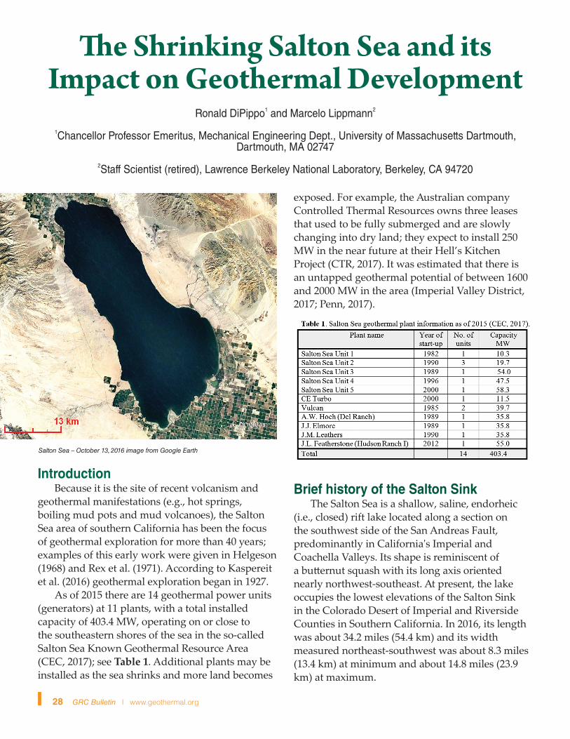
Salton Sea – October 13, 2016 image from Google Earth
exposed. For example, the Australian company Controlled Thermal Resources owns three leases that used to be fully submerged and are slowly changing into dry land; they expect to install 250 MW in the near future at their Hell’s Kitchen Project (CTR, 2017). It was estimated that there is an untapped geothermal potential of between 1600 and 2000 MW in the area (Imperial Valley District, 2017; Penn, 2017).
Brief history of the Salton Sink The Salton Sea is a shallow, saline, endorheic
(i.e., closed) rift lake located along a section on the southwest side of the San Andreas Fault, predominantly in California's Imperial and Coachella Valleys. Its shape is reminiscent of a butternut squash with its long axis oriented nearly northwest-southeast. At present, the lake occupies the lowest elevations of the Salton Sink in the Colorado Desert of Imperial and Riverside Counties in Southern California. In 2016, its length was about 34.2 miles (54.4 km) and its width measured northeast-southwest was about 8.3 miles (13.4 km) at minimum and about 14.8 miles (23.9 km) at maximum.
July/August 2017 29
According to Singer (http://fire.biol.wwu.edu/trent/alles/SingerImperialValley.pdf; Chs. 7, 8, 10), the Salton Sink has a history spanning hundreds of thousands of years of alternately being filled with an enormous fresh water lake and being an arid, empty desert. It all depended on the course being taken by the nearby Colorado River together with the rates of water inflow and evaporation. A lake would exist only when it was replenished by the river, a cycle that repeated itself countless times over. The last of the ancient lakes that occupied the basin was Lake Cahuilla, the shorelines of which are still visible on the hills that border the present valley.
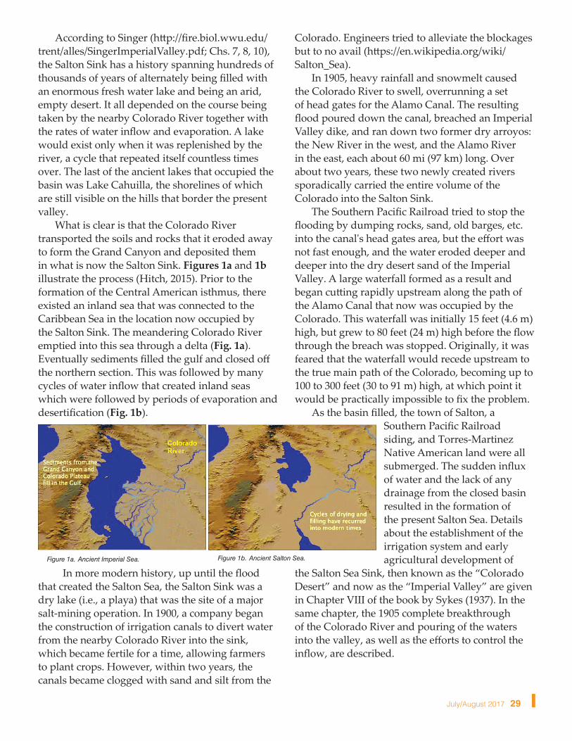
What is clear is that the Colorado River transported the soils and rocks that it eroded away to form the Grand Canyon and deposited them in what is now the Salton Sink. Figures 1a and 1b illustrate the process (Hitch, 2015). Prior to the formation of the Central American isthmus, there existed an inland sea that was connected to the Caribbean Sea in the location now occupied by the Salton Sink. The meandering Colorado River emptied into this sea through a delta (Fig. 1a). Eventually sediments filled the gulf and closed off the northern section. This was followed by many cycles of water inflow that created inland seas which were followed by periods of evaporation and desertification (Fig. 1b).
In more modern history, up until the flood that created the Salton Sea, the Salton Sink was a dry lake (i.e., a playa) that was the site of a major salt-mining operation. In 1900, a company began the construction of irrigation canals to divert water from the nearby Colorado River into the sink, which became fertile for a time, allowing farmers to plant crops. However, within two years, the canals became clogged with sand and silt from the
Colorado. Engineers tried to alleviate the blockages but to no avail (https://en.wikipedia.org/wiki/Salton_Sea).
In 1905, heavy rainfall and snowmelt caused the Colorado River to swell, overrunning a set of head gates for the Alamo Canal. The resulting flood poured down the canal, breached an Imperial Valley dike, and ran down two former dry arroyos: the New River in the west, and the Alamo River in the east, each about 60 mi (97 km) long. Over about two years, these two newly created rivers sporadically carried the entire volume of the Colorado into the Salton Sink.
The Southern Pacific Railroad tried to stop the flooding by dumping rocks, sand, old barges, etc. into the canal's head gates area, but the effort was not fast enough, and the water eroded deeper and deeper into the dry desert sand of the Imperial Valley. A large waterfall formed as a result and began cutting rapidly upstream along the path of the Alamo Canal that now was occupied by the Colorado. This waterfall was initially 15 feet (4.6 m) high, but grew to 80 feet (24 m) high before the flow through the breach was stopped. Originally, it was feared that the waterfall would recede upstream to the true main path of the Colorado, becoming up to 100 to 300 feet (30 to 91 m) high, at which point it would be practically impossible to fix the problem.
As the basin filled, the town of Salton, a Southern Pacific Railroad siding, and Torres-Martinez Native American land were all submerged. The sudden influx of water and the lack of any drainage from the closed basin resulted in the formation of the present Salton Sea. Details about the establishment of the irrigation system and early agricultural development of
the Salton Sea Sink, then known as the “Colorado Desert” and now as the “Imperial Valley” are given in Chapter VIII of the book by Sykes (1937). In the same chapter, the 1905 complete breakthrough of the Colorado River and pouring of the waters into the valley, as well as the efforts to control the inflow, are described.
Figure 1b. Ancient Salton Sea.Figure 1a. Ancient Imperial Sea.
30 GRC Bulletin l www.geothermal.org
The Salton Sea originally had some success as a resort area, with Salton City, Salton Sea Beach, and Desert Shores on the western shore, and Desert Beach, North Shore, and Bombay Beach built on the eastern shore in the 1950s. Speedboat races were popular as tremendous speeds could be achieved in the highly buoyant saline water. However, many of the settlements substantially shrank in size, or have been abandoned, mostly due to the increasing salinity and pollution of the lake over the years from agricultural runoff and other sources. Many of the species of fish that lived in the sea, mainly tilapia, have been killed off by the combination of pollutants, salt levels, and algal blooms. Dead fish have been known to wash up in mass quantities on the beaches. The smell of the lake, combined with the stench of the decaying fish, also contributed to the decline of the tourist industry around the Salton Sea.
Twenty-five years of sea changesThe controversial 2003 Quantification
Settlement Agreement (QSA) forged among several stakeholders and agencies established a plan for the allocation of Colorado River water (https://en.wikipedia.org/wiki/Quantification_Settlement_Agreement; http://www.desertsun.com/story/news/environment/2015/02/03/qsa-settlement-imperial-county/22829969/).
While attempting to maintain sufficient amounts of water for agriculture, while at the same time meeting the domestic needs of metropolitan areas of southern California, it is feared that the QSA provides little water to the Salton Sea, leaving it largely to evaporate during drought conditions (Dávila Fragoso, 2016).
On the one hand, environmentalists argue that exposing more dry land leads to more polluted dust in the air which in turn leads to health problems for residents, while on the other hand, developers would have access to geothermal resources that have been unavailable since 1907 when the artificial sea was formed. In 1927 the water level was at 241 feet (73.5 m) below sea level; as of February 5, 2017 its surface is 235.2 ft (71.7 m) below sea level, a gain of nearly six feet (2 m). However, various values can be found for its surface elevation in the literature. One important reason for the discrepancy is that the water level
is now dropping by about six inches (152 mm) per year owing to evaporation. It has been estimated that without any river inflows the sea will be completely dry in about 10 years.
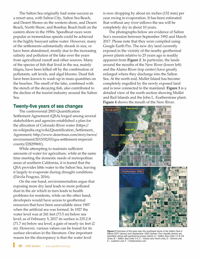
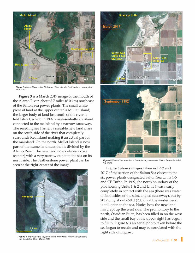
The photographs below are evidence of Salton Sea’s recession between September 1992 and March 2017. Please note that they were compiled using Google Earth Pro. The new dry land currently exposed in the vicinity of the nearby geothermal power plants relative to 25 years ago is readily apparent from Figure 2. In particular, the lands around the mouths of the New River (lower left) and the Alamo River (top center) have greatly enlarged where they discharge into the Salton Sea. At the north end, Mullet Island has become completely engulfed by the newly exposed land and is now connected to the mainland. Figure 3 is a detailed view of the north section showing Mullet and Red Islands and the John L. Featherstone plant. Figure 4 shows the mouth of the New River.
Figure 2 Overview of the area near the southeast shore of the Salton Sea in March 2017 (above) and September 1992 (below). Four rhyolite domes are identified, along with geothermal power plants: A – Salton Sea Units 1-2 & CE Turbo, B – Salton Sea Units 3-5, C – Vulcan and Hoch units, D – Elmore unit, E – Leathers unit, F – Featherstone unit.
July/August 2017 31
Figure 3 is a March 2017 image of the mouth of the Alamo River, about 3.7 miles (6.0 km) northeast of the Salton Sea power plants. The small white piece of land at the upper center is Mullet Island; the larger body of land just south of the river is Red Island, which in 1992 was essentially an island connected to the mainland by a narrow causeway. The receding sea has left a sizeable new land mass on the south side of the river that completely surrounds Red Island making it an actual part of the mainland. On the north, Mullet Island is now part of that same landmass that is divided by the Alamo River. The new land now defines a cove (center) with a very narrow outlet to the sea on its north side. The Featherstone power plant can be seen at the right-center of the image.
Figure 5 shows images taken in 1992 and 2017 of the section of the Salton Sea closest to the six power plants designated Salton Sea Units 1-5 and CE Turbo. In 1992, the north boundary of the plot housing Units 1 & 2 and Unit 3 was nearly completely in contact with the sea (there was water on both sides of the slim, angled causeway), but by 2017 only about 650 ft (200 m) at the western end is still open to the sea. Notice how the new land has crept up the west side. The promontory to the north, Obsidian Butte, has been filled in on the west side and the small bay at the upper right has begun to fill in. Figure 6 is an aerial photo taken before the sea began to recede and may be correlated with the right side of Figure 5.
Figure 3. Alamo River outlet, Mullet and Red Islands, Featherstone power plant: March 2017.
Figure 4. Exposed land adjacent to the New River where it discharges into the Salton Sea: March 2017.
Figure 5. View of the area that is home to six power units: Salton Sea Units 1-5 & CE Turbo.

32 GRC Bulletin l www.geothermal.org
The futureFor several decades Californians have been
studying and debating ideas about saving the Salton Sea. Finally, plans to solve the problems caused by the shrinking sea are taking shape (e.g., James, 2016; Imperial Irrigation District, 2017; Sahagun, 2017; State of California, 2017).
For more than a century, lake inflows have been primarily from agricultural activities in the area. Water inflows from the New and Alamo Rivers are primarily farm return flow water, although there is some inflow from Mexico, particularly during large precipitation events. The water levels in the Salton Sea have declined and salinity concentrations have increased due to climate fluctuations, agricultural conservation measures, cropping practices and reduced inflows from Mexico. Recent water transfers from the Imperial Valley have further accelerated the rate of lake elevation decline and have increased the rate of salinity concentration (State of California, 2017).
Unless the proposed corrective measures detailed in the references given in the last section are implemented, the declining lake levels will continue threatening important bird habitats, decimate fish populations and pose public health risks due to particulate air pollution.
One positive effect of the receding lake will be the availability of more dry land to site geothermal wells and power plants, considering that the geothermal resource extends northwestward beyond the existing lake shoreline (e.g., Hulen et al., 2002; 2003). Recently, Kaspereit et al. (2016) estimated that the power potential for the Salton Sea geothermal field as 2950 MW, part of it in areas
Figure 6. Salton Sea Units 1, 2, 3 and 4, circa 2000, view looking northeast. Note that Obsidian Butte is essentially an island connected to the mainland by narrow causeways on its south and east sides. Compare with Fig. 5 (right).
presently submerged. Of that total, 2250 MW are currently developable, while the remaining 700 MW would become available as the lake shrinks in size. These estimates make the field one of the largest in the world.
However, these estimates use the method of volumetric energy storage and involve a string of multiplying factors that cannot be well-quantified prior to drilling. The temperatures and chemical characteristics of the geofluid expected to be found under the new land will need to be determined, and appropriate methods explored and adopted to cope with any potential problems of scaling and corrosion. Besides these issues, there are many others that influence how much of the geothermal reserve may ultimately be brought online. These include securing a suite of permits for all aspects of the development, power purchase agreements, adequate make-up water for cooling, protection from subsidence, etc.
We conclude that while it is fine to anticipate a productive use for the 925 acres (3.75 km2) of new dry land being created each year by the shrinking Salton Sea, it is appropriate to temper optimism for hundreds of new megawatts of power with some practical common sense.
ReferencesCEC (2017). California Energy Commission,
California Geothermal Energy Statistics & Data: http://www.energy.ca.gov/almanac/renewables_data/geothermal/
CTR (2017). Controlled Thermal Resources, Hell’s Kitchen Geothermal Project, Imperial Valley, CA. http://www.cthermal.com/project/
Dávila Fragoso, A. (2016). Inside the Looming Disaster of the Salton Sea. ThinkProgress, May 19, 2016: https://thinkprogress.org/inside-the-looming-disaster-of-the-salton-sea-e5c94e0e9b6a
Helgeson, H.C. (1968). Geologic and thermodynamic characteristics of Salton Sea geothermal system, Am. J. Sci., 266, 129–166.
Hitch, N.V. (2015). A history of water - and the Salton Sea - in Imperial, Imperial Valley Press, March 21. 2015: http://www.ivpressonline.com/life/desertmuseum/a-history-of-water-and-the-salton-sea-in-imperial/article_40c423a4-c9d3-5aa7-8255-e43ea4c6a559.html
July/August 2017 33
Hulen, J. et al. (2002). Refined Conceptual Modeling and a New Resource Estimate for the Salton Sea Geothermal Field, Imperial Valley, California. Geothermal Resources Council Transactions, vol. 26, pp. 29-36.
Hulen, J. et al. (2003). Geology and a Working Conceptual Model of the Obsidian Butte (Unit 6) Sector of the Salton Sea Geothermal Field, Imperial Valley, California. Geothermal Resources Council Transactions, vol. 27, pp. 227-240.
Imperial Valley District (2017). Salton Sea Restoration and Renewable Energy Initiative. http://www.iid.com/water/salton-sea-initiative
James, I. (2016). California has a new $383 million plan for the shrinking Salton Sea. The Desert Sun newspaper article, March 3, 2016. http://www.desertsun.com/story/news/environment/2017/03/16/california-has-new-383-million-plan-shrinking-salton-sea/99124850/
Kaspereit, D. et al. (2016). Updated Conceptual Model and Reserve Estimate for the Salton Sea Geothermal Field, Imperial Valley, California. Geothermal Resources Council Transactions, vol. 40, pp. 57-66.
Penn, I. (2017). Australian firm plans nation's largest geothermal plant in Imperial Valley. Los
Angeles Times newspaper article, January 14, 2017. http://www.latimes.com/business/la-fi-geothermal-salton-sea-20170114-story.html
Rex, R.W. et al. (1971). Cooperative geological-geophysical-geochemical investigations of geothermal resources in the Imperial Valley Area of California. University of California Riverside, Education Research Service, report dated July 1, 1971, 154 pp.
Sahagun, L. (2017). State unveils a 10-year plan to restore habitat and control toxic dust storms along the Salton Sea's receding shoreline. Los Angeles Times newspaper article, March 3, 2017. http://www.latimes.com/local/california/la-me-salton-sea-20170317-story.html
State of California (2017). Salton Sea Management Program Phase I: 10-Year Plan - March 2017. State of California report, 54 pp. http://resources.ca.gov/docs/salton_sea/ssmp-10-year-plan/SSMP-Phase-I-10-YR-Plan-with-appendices.pdf
Sykes, G. (1937). The Colorado Delta. Kennikat Press, Port Washington, NY/London, 193 pp. n
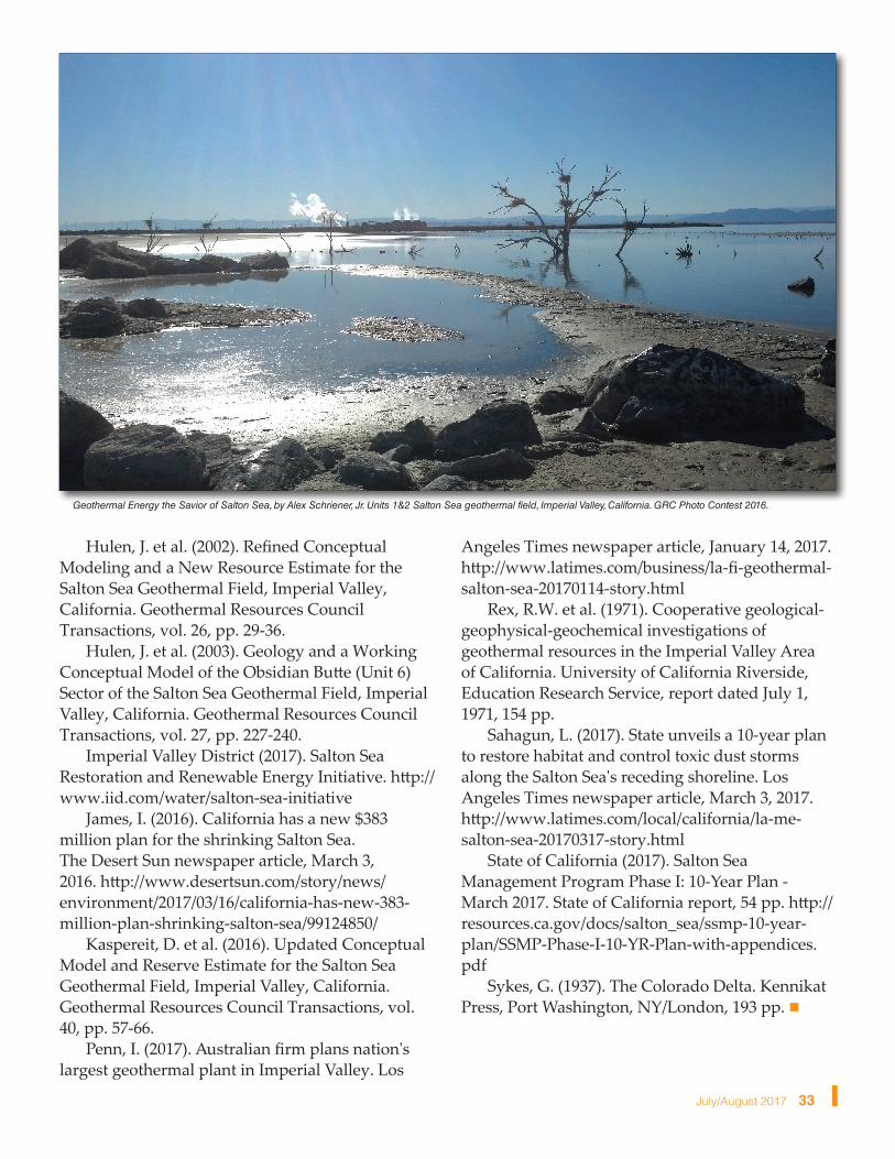
Geothermal Energy the Savior of Salton Sea, by Alex Schriener, Jr. Units 1&2 Salton Sea geothermal field, Imperial Valley, California. GRC Photo Contest 2016.