the south/southeast asia research initiative...
TRANSCRIPT

The South/Southeast Asia Research Initiative (SARI)
Krishna Prasad VadrevuNASA SARI Lead
University of Maryland College Park, USAand
SARI Core Team

• Background to the SARI initiative
• SARI Science Rationale
• SARI Program Coordination and Current Activities
• Next Steps
Presentation topics

• The South/Southeast Asia region is undergoing rapid land cover/land use changes due to population growth and economic development with implications for greenhouse gas emissions, hydrology, biodiversity, land atmosphere interactions, human livelihood.
• Satellite data are used widely by regional scientists (NASA and ISRO data) for land use/cover change studies.
• Much of the research using satellite data has societal relevance with a developing country perspective.
• Good collaboration exists between NASA LCLUC and Regional Scientists from South/Southeast Asia (Myanmar – just started).
Background to SARI Initiative

How it started - strong interest in a SARI from local scientists
Jan-10-13th, 2013-Regional Science Meeting, Coimbatore
Total participants =120US – 18 researchers
Nepal-3; Srilanka-2; Myanmar-1; Afghanistan, Myanmar, Bangladesh-1 eachPakistan, China invited but could not attend – Visa issues
India – University Researchers, Government, Non-Government, NGO’s

• Precedents for NASA initiated Regional Integrated Science Initiatives
• TE – ISLSCP (International Satellite Land Surface Climatology Project; Boreas, LBA (Large Scale Biosphere-Atmosphere-Experiment in Amazonia), ABOVE (Arctic Boreal Vulnerability Experiment)
• SAFARI (2000-2005)
• NEESPI - Northern Eurasia Earth Science Partnership Initiative (2006-2015) – transition to Future Earth..
• MAIRS – Monsoon Asia Integrated Regional Study (2006 –2014) - initiated by China, implemented by START, supported by LCLUC - transition to Future Earth..
Background

- Unanimous agreement for the development and need for SARI.- International programs such as GOFC-GOLD, START, MAIRS, GEO-
GLAM, etc. should be engaged as a means to strengthen SARI.
- A series of SARI planning workshops needed to converge on a science plan, identify, prioritize and address regional scale questions.
- SARI to aid in:- Developing and strengthening bilateral science collaborations
among SARI + US and other countries.- Enable data collection and sharing mechanisms. - Assist in capacity building activities.
- Funding mechanisms needs to be explored through national/regional as well as international sources through Regional Scientists involvement.
Regional Priorities – Workshop Panel Summary

Meeting Summary-The Earth Observer
March/April 2013
http://eospso.gsfc.nasa.gov/eos_homepage/for_scientists/earth_observer.php

Discussions at the meeting by some LCLUC principal players raised the desirability and opportunity for a research initiative
SARI – Core Team

SARI - Goal
To develop an innovative research, education, and capacity building program involving state-of-the-art remote sensing, natural sciences, engineering and social sciences to enrich LCLUC science in South/Southeast Asia.

To strengthen the theoretical underpinnings of LCLUC science in the Asian region. SARI will help in:
• Developing new science partnerships between space agencies,
research agencies, universities and non-government organizations;
• Developing integrated methodologies for regional scale LCLUC products; enhancing data sharing mechanisms;
• Organizing international workshops to exchange science results and formulate new research projects;
• Conducting capacity building programs, facilitating leadership training and experience;
• Facilitating international student/researcher exchange.
SARI Objectives

SARI Science Rationale


• Nearly 60% of worlds population is in Asia (4.5 billion people); of which South/Southeast Asia accounts for ~70%.
• Nearly 2/3rd of world population growth is in Asia
• Nearly 50 million people are being added every year!
Population

• In recent years, Croplands in the region are have been decreasing rapidly due to increasing urbanization and industrialization.
• To meet the demands of the growing population, more than 80% of the increase in production will have to come from yield increase, since there is very little scope for expansion of agricultural lands.
Agricultural LCLUC
• Increasing extreme events are negatively affecting agricultural production
Understanding cropland changes and the impact of intensive agricultural practices on ecosystem services require integrated approaches.

• Urbanization is occurring rapidly at the cost of agriculture and forest lands.
• Currently, 28.33% of South/Southeast Asian population lives in urban areas and it is estimated that by 2030, more than 55% of the population will be urban.
• Urban sprawl has been increasing in different cities at the cost of agricultural lands, ecologically sensitive and natural areas.
• Increasing Urbanization is resulting in air, water and solid waste pollution problems in most cities.
Urbanization and LCLUC
• LCLUC interactions in urban environments are poorly understood and need immediate attention.
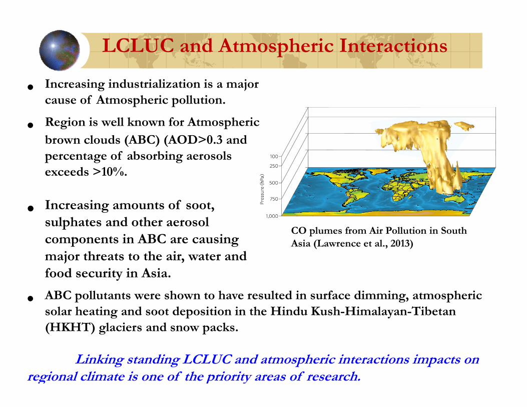
• Increasing industrialization is a major cause of Atmospheric pollution.
• Region is well known for Atmosphericbrown clouds (ABC) (AOD>0.3 and percentage of absorbing aerosols exceeds >10%.
• Increasing amounts of soot, sulphates and other aerosol components in ABC are causing major threats to the air, water and food security in Asia.
LCLUC and Atmospheric Interactions
• ABC pollutants were shown to have resulted in surface dimming, atmospheric solar heating and soot deposition in the Hindu Kush-Himalayan-Tibetan (HKHT) glaciers and snow packs.
Linking standing LCLUC and atmospheric interactions impacts on regional climate is one of the priority areas of research.
CO plumes from Air Pollution in South Asia (Lawrence et al., 2013)

• Floods: Although a natural calamity, poor land use planning and unplanned development in the hill areas through road construction, buildings, hydro-power projects and mining the river beds aggravating the havoc.
• Droughts: The South Asian countries have been among the perennially drought-prone regions of the world. For example, Afghanistan, India, Pakistan and Sri Lanka have reported droughts at least once in three years in the past five decades (SAARC, 2012).
Region with high extreme events
• Landslides: Several mountain regions of Pakistan, Afghanistan, India and Myanmar are impacted by landslides.
Understanding the linkages between LCLUC and extreme events such as fires, floods, tsunamis, droughts, etc., is important to aid mitigation efforts.

• The projected warming due to the combined effect of greenhouse gas and sulfate aerosols over Asia is estimated to increase 2.7-3.7 degree C by the 2050’s (AR-5).
• Rainfall more extreme near the center of tropical belts making landfall in South Asia.
• Increased surface temperatures can have drastic effect on:
• Glacier melts; Ag. Yield loss; Severe droughts in some regions;Decrease water availability
Climate Change Issues
In the Asian countries, Adaptive capacity of humans is low and vulnerability is high.
Ashfaq et al., (2009)

• Characterize the nature, magnitude, drivers and impacts of LCLUC in South Asia.
• Assist in the development of regional scale land surface and socioeconomic products useful for LCLUC research.
• Address LCLUC interactions on climate, water resources, biodiversity, atmosphere, etc.
• Address the vulnerability, impacts and adaptation issues associated with LCLUC.
• Develop regional scale land cover change models useful for decision support.
• Develop an understanding of LCLUC dynamics through facilitating systematic and integrated case studies.
Research Focus Areas

Coordination and on-going activities

SARI Update and Next Steps
• Phase-I. Design Phase - Completed
• Organizational Committee with Co-leads and Task Force members formed
• SARI Formulation Leads: Krishna Vadrevu and Rama
Nemani
• Task-Force leads: Ruth DeFries, Karen Seto, Dan Brown, Chris Justice, Thenkabail Prasad (USGS), Ivan Csiszar(NOAA),
• Regional leads: In formation
• Science plan prepared highlighting the need for SARI and Action Plan.
• Initial Projects funded through LCLUC ROSES

• Phase-II Implementation – On going
• Project Office established;
• Burma Meeting, January, 2016 – Official Regional launch of SARI;
• Regional Review/Feedback on draft science plan in South Asia planned;
• Organizing internationally sponsored regional workshops to bring researchers together and identify priority areas.
SARI Update and Next Steps

Project Office Task-1: Development of Science Advisory Group Involving Regional Scientists and Implementation Teams

Task-2: Serve as a Liaison between SARI and the NASA LCLUC program. SARI project office will help in building collaborations/partnerships between the US and regional scientists.
Task-3: Facilitate NASA LCLUC Science Team meetings in South/Southeast Asia. SARI website for updates.
Task-4: Capacity building and training activities. Co-funding for some of the meetings secured through JAXA-National Institute of environmental
Studies (NIES), Japan.
Task-5: Promotion of NASA products + regional datasets
Task-6: Publications, journal special issues, books, brochures.
Project Office Tasks

Landsat images for the whole country of Myanmar Images from
new Landsat sensor L8 for the period of January‐March, 2015.
LANDSAT-8 – 2015 – CLOUD FREE IMAGES
FREE LANDSAT-8 DATA
Contact: Sumalika Biswas

• Jefferson Fox – East West Center, Hawaii -Twenty-Five Years of Community Forestry: Mapping Forest Dynamics in the Middle Hills of Nepal – 2015-2018
• Atul Jain, University of Illinois at Urbana Champaign - Land Cover and Land Use Changes and Their Effects on Carbon Dynamics in South and South East Asia: A Synthesis Study – 2014-2017
• Jinwei Dong – Oklahoma State University-Mapping Industrial Forest Plantations in tropical Monsoon Asia Through Integration of Landsat and PALSAR Imagery – 2014-2017
• Ruth DeFries- Columbia University - Multi-sensor Fusion to Determine Climate Sensitivity of Agricultural Intensification in South Asia-2011-2014
• Karen Seto – Yale University - Multi-Scale and Multi-Sensor Analysis of Urban Cluster Development and Agricultural Land Loss in China and India - 2011-2014
Previous LCLUC projects in SARI region

• Additional NASA LCLUC projects (LCLUC ROSES 2015call)
• Bring together existing national and regional projects
• Exploring new non-NASA funding sources for SARI
• International (Belmont Forum, USAID, NIES, Japan, etc.)
• National – Dept. of Science and Technology (India); Private Companies, etc.
Phase II – Implementation Phase

Inclusion of SEA Countries in SARI underway (4 Regional Workshops already funded by NIES Japan and Regional partners)

Volume-I Volume-II

This meeting outputs – “Remote Sensing” journal special issue solicitation

SARI website www.sari.umd.edu