the study on sustainable development through eco-tourism
TRANSCRIPT

Ministry of Physical Planning and Environment(Federation of Bosnia and Herzegovina / FBiH) Japan International Cooperation Agency (JICA) Ministry of Physical Planning, Civil Engineering and Ecology (The Republic of Srpska / RS) Ministry of Trade (Federation of Bosnia and Herzegovina / FBiH) Ministry of Trade And Tourism (The Republic of Srpska / RS)
The Study on Sustainable Development
through Eco-Tourism
In Bosnia and Herzegovina Final Report
ANNEX 2
March 2005
PADECO Co., Ltd in association with
Pacific Consultants International

Ministry of Physical Planning and Environment Japan (Federation of Bosnia and Herzegovina / FBiH), International Ministry of Physical Planning, Civil Engineering and Ecology Cooperation (The Republic of Srpska / RS), Agency Ministry of Trade (JICA) (Federation of Bosnia and Herzegovina / FBiH) Ministry of Trade And Tourism (The Republic of Srpska / RS)
The Study on Sustainable Development
through Eco-Tourism
In Bosnia and Herzegovina
Final Report
ANNEX 2
March 2005
PADECO Co., Ltd in association with
Pacific Consultants International

The Study on Sustainable Development through Eco-Tourism in Bosnia and Herzegovina Final Report
The Study on Sustainable Development through Eco-tourism in
Bosnia and Herzegovina
Final Report
Table of Contents
ANNEX 2 GIS MAPS
1. Outline................................................................................................................................1 1.1 Introduction.................................................................................................................1 1.2 Outline of GIS Maps ...................................................................................................1
1.2.1 Input Map Items.................................................................................................1 1.2.2 Data Processing ................................................................................................1 1.2.3 Analysis Result..................................................................................................1
2. Map Description ................................................................................................................1 2.1 Base Maps..................................................................................................................1 2.2 Data Processing – Pliva Study Area ...........................................................................2 2.3 Data Processing – Velez Study Area ..........................................................................2 2.4 Analysis Result ...........................................................................................................3
List of Maps
Base Maps Map 1. 1 Index of Collected Maps in 1:25,000 Scale................................................4 Map 1. 2 Sample of 1:25,000 Scale Map (This is in 50 % Scale) .............................5 Map 1. 3 Index of Collected Aerial Photo ..................................................................6 Map 1. 4 Index of Collected Maps in 1:2,500 and 1:5,000 Scale..............................7 Map 1. 5 Sample of 1:2,500 Scale Map (This is in 33 % Scale) ...............................8
Data Processing – Pliva Study Area Map 2. 1 General Map ..............................................................................................9 Map 2. 2 Aerial Photo..............................................................................................10 Map 2. 3 Land Cover............................................................................................... 11 Map 2. 4 Elevation ..................................................................................................12 Map 2. 5 Slope Gradient .........................................................................................13 Map 2. 6 Forest .......................................................................................................14
Map 2. 7 Water Body ..............................................................................................15 Map 2. 8 Road Network ..........................................................................................16 Map 2. 9 Locations related to Pilot Projects............................................................17 Map 2. 10 Sample of Mine Contamination Map created by BHMAC in Oct. 2004....18 Map 2. 11 Cultural Historical Heritage ......................................................................19
Data Processing – Velez Study Area Map 3. 1 General Map ............................................................................................20 Map 3. 2 Aerial Photo..............................................................................................21 Map 3. 3 Land Cover...............................................................................................22 Map 3. 4 Elevation ..................................................................................................23 Map 3. 5 Slope Gradient .........................................................................................24 Map 3. 6 Forest .......................................................................................................25 Map 3. 7 Water Body ..............................................................................................26 Map 3. 8 Road Network ..........................................................................................27 Map 3. 9 Locations related to Pilot Projects............................................................28 Map 3. 10 Sample Map related to Pilot Project.........................................................29 Map 3. 11 Sample of Mine Contamination Map created by BHMAC in Oct. 2004....30 Map 3. 12 Cultural Historical Heritage ......................................................................31
Analysis Result Map 4. 1 Proposed Ecological Zones of Pliva Study Area ......................................32 Map 4. 2 Proposed Ecological Zones of Velez Study Area .....................................33
Abbreviations and Acronyms
BHMAC Bosnia and Herzegovina Mine Action Center BiH Bosnia and Herzegovina CORINE Coordinate Information on the Environment DTM Digital Terrain Model EEA European Environmental Agency FAO Food and Agriculture Organization of the United Nations GIS Geographical Information System IUCN International Union for Conservation of Nature and Natural Resources JICA The Japan International Cooperation Agency MoE FBiH Ministry of Physical Planning and Environment of Federation of Bosnia
and Herzegovina RS the Republic of Srpska
ANNEX 2 - i

The Study on Sustainable Development through Eco-Tourism in Bosnia and Herzegovina Final Report
1. Outline 1.1 Introduction Based on a number of map data collected through the project, JICA Study Team developed a GIS data base to support an analysis and visualization for sustainable development through eco-tourism. Through the GIS technique, the collected basic data maps were fully processed and analyzed to understand spatial distribution of both environmental and socio-economical constraints of the study area against eco-tourism development. Results of those data analysis were displayed in forms of maps and tables. This “GIS Maps” compiles a number of selected outputs out of the results of this study. The existing geographic, natural and social condition and the results of ecological zoning were visually compiled. This volume was prepared as an additional material to supplement the main report of this study. These will contribute to those who are concerned with research and planning works of urban to rural environment or solution of land use problems of the Pliva and Velez Regions. All the database files are listed and described in ANNEX 1. GIS database development process is also explained in it. All the row data (approximately 70 GB) is submitted to the counterpart agencies together with the computer system, GIS software and final reports.
1.2 Process of GIS Maps The process is written in the main report and ANNEX. Following description is their summary.
1.2.1 Input Map Items The Study Team collected all available base maps for the study areas, such as 1:25,000, 1:50,000, 1:100,000 and 1:200,000 scales. Additionally, JICA and JICA’s Mapping Project support this study by aerial photos, 1:5,000 maps, 1:2,500 maps and revised 1:25,000 (draft) maps. Index maps of developed GIS database and samples are shown on this volume. All other important maps were also collected, for example,
• BiH’s National Environmental Action Plan (NEAP), • BiH’s physical plan, • RS’s nature protection plan, • the land cover data of CORINE project for BiH carried
out by EEA (data files was received from MoE FBiH),
• FAO’s land resource, and • BHMAC’s mine situation map
1.2.2 Data Processing All the input maps were used for current situation study, field works and planning. Contour line, road network and water surface data were extracted from digitized data of 1:25,000 maps. From this contour line data, digital terrain model (DTM), slope and hill shade data were processed. Forest, agriculture and built-up area database were extracted from EEA’s CORINE land cover data. These entire GIS data were overlaid to each others, after datum, spheroid and projection were setup. Maps in brochures and flyers were also created from this GIS database.
1.2.3 Analysis Result Ecological zoning analysis was processed by overlay of GIS data above, field survey result and literature research.
2. Map Description 2.1 Base Maps Map 1. 1 Index of Collected Maps in 1:25,000 Scale 1:25,000-scale map was selected as the base map for the study areas. 24 sheets of the latest maps (created in 1976) were collected for Pliva Study Area. JICA’s Mapping Project is revising 5 map sheets in 2004, drafts of which were provided to this study. 24 sheets in 1972 to 1973 were collected for Velez Study Area. JICA’s Mapping Project is revising 10 map sheets in 2004, drafts of which were provided to this study. Additionally, 20 sheets in 1973 were collected, which covers comparative areas such as Medjugorje, Pocitelj, Hutovo Blato, Jahorina, Bijelasnica, Prenj, Vranica, and Cvrsnica. Map 1. 2 Sample of 1:25,000 Scale Map (This is in 50 % Scale) This sample is one of the drafts from the revising work of JICA’s Mapping Project. This sample is printed in 50 % scale in order to fit to this A3 report. It is based on aerial photos in 2003, and field survey in 2004. It reflects new features such as roads, towns, villages and land cover. Map 1. 3 Index of Collected Aerial Photo JICA’s Mapping Project took aerial photos in year 2003, covering whole BiH. The resolution is approximately 60 cm. All the
ANNEX 2 - 1

The Study on Sustainable Development through Eco-Tourism in Bosnia and Herzegovina Final Report
aerial photos related to its study areas (227 scenes) were supplied. This map is the index of the collected aerial photos, showing their IDs. Map 1. 4 Index of Collected Maps in 1:2,500 and 1:5,000 Scale Detailed maps for specified areas were necessary for the tourism resource analysis and planning. Ministry of Civil Affairs, Bosnia and Herzegovina, and JICA Headquarters accepted our request and JICA’s Mapping Project developed 1:2,500 and 1:5,000 scale maps for the selected areas. It covers the source of Pliva River to the centre of Jajce along Pliva River, the source of Buna and Bunica River to the meeting point to Neretva River, the centre of Pocitelj, and the centre of Ravno. This index map shows the coverage, map code and scale. Map 1. 5 Sample of 1:2,500 Scale Map (This is in 33 % Scale) This sample is printed in 33 % scale in order to fit to this A3 report It shows all the streets, buildings and any other small features, appropriate for detailed planning.
2.2 Data Processing – Pliva Study Area Map 2. 1 General Map Map 2. 2 Aerial Photo Map 2. 3 Land Cover These base maps show the general geographic of Pliva Study Area and its surroundings.
Large part of the study area is covered by forest, consists of broad-leaved forest, coniferous forest and mixed forest. Central region of Sipovo Municipality area and of Jajce Municipality area is developed area for agriculture. Semi natural areas, such as natural grassland and transitional woodlands-scrub, are mainly found between agriculture and forest areas in Sipovo Municipality area. Main national roads run across the centre of Jajce. Map 2. 4 Elevation Map 2. 5 Slope Gradient Map 2. 6 Forest Map 2. 7 Water Body Map 2. 8 Road Network These environmental thematic maps were processed from
• GIS data digitized by JICA’s Mapping Project, and • Land cover data by CORINE project of EEA.
Following figure shows the flow of data processing.
1:25.000 maps of former Yugoslavia, 1972 ~ 1976Digital mapping on Aerial Photos 2003
Digitized GIS data
Contour lines Elevation (25m Grid) Slope gradient
Land cover (CORINE, EEA, 2000)
Forest
Built-up Area
Water body
Road network
Source: JICA Study Team
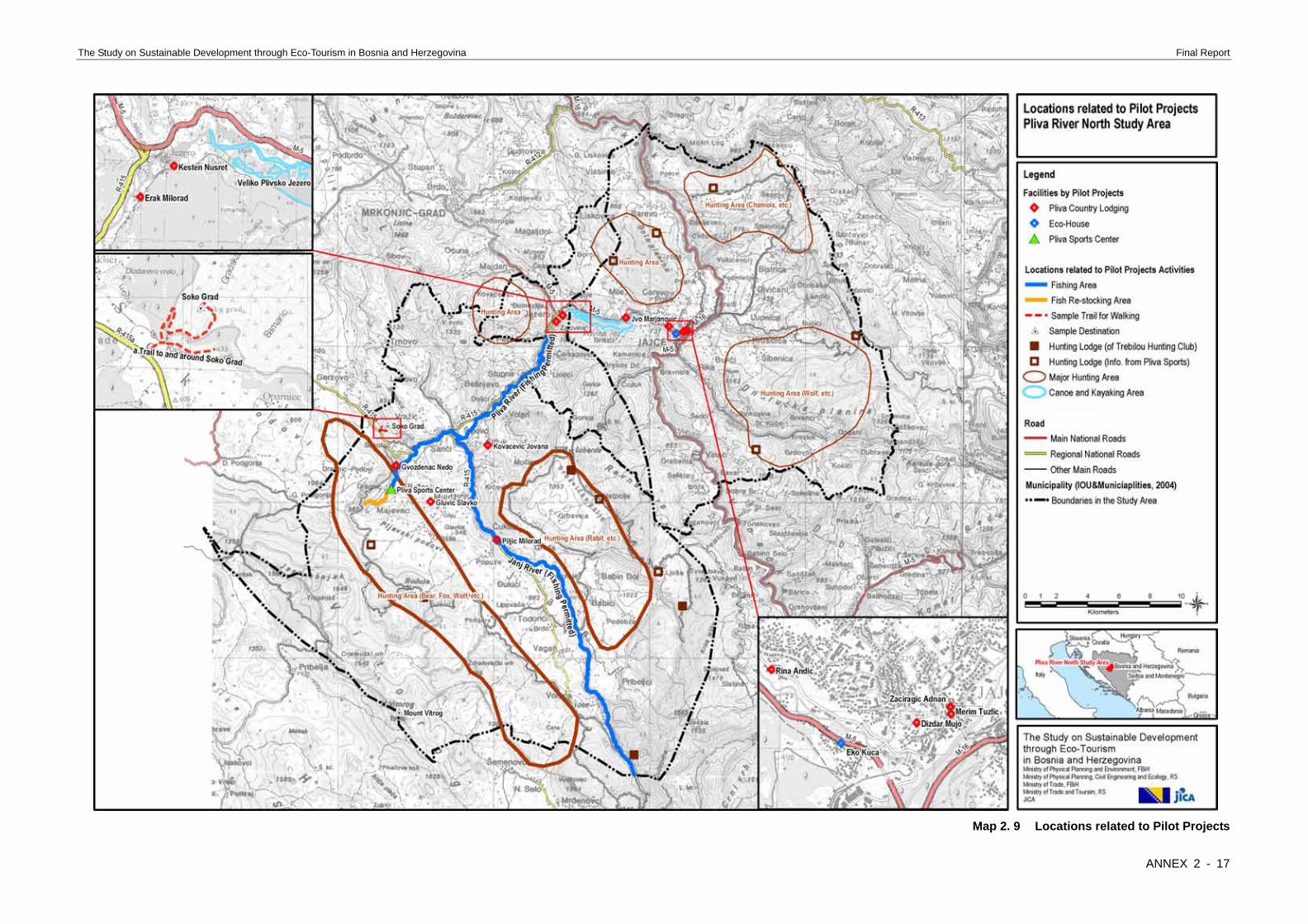
Elevation is between 270 m and 1905 m. Slope gradient ranges from 0 % to 319 %. Forest is the main land cover in the study area. Its area ratio is 56.6 %. Year-round rivers are found in region from the lower part of Sipovo Municipality area to Jajce Municipality area. Seasonal rivers are dominated in the upper part of Janj River. There is no significant river on the slope of Mount Vitrog. Map 2. 9 Locations related to Pilot Projects This map shows the locations of facilities and activity areas related to the pilot projects carried out by JICA Study. Map 2. 10 Sample of Mine Contamination Map created by BHMAC in Oct. 2004 BHMAC published this mine contamination map in October 2004, which shows areas with known contamination of mines and unexploded ordnance. BHMAC always updates the mine contamination map. Any planning should be always carried out after the updated ones are reviewed. Map 2. 11 Cultural Historical Heritage This cultural historical heritage map is based on “Physical Plan BiH, 1981-2000” and “Commission to Preserve National Monuments, BiH, 2003”. It is found that there are many heritage resources that is not yet actively used in tourism industry.
2.3 Data Processing – Velez Study Area Map 3. 1 General Map Map 3. 2 Aerial Photo Map 3. 3 Land Cover These base maps show the general geographic of Velez Study
ANNEX 2 - 2

The Study on Sustainable Development through Eco-Tourism in Bosnia and Herzegovina Final Report
Area and its surroundings. “Transitional woodland-scrub” and “moors and heath land” are dominant in former Southeast Mostar Municipality. “Agricultural area”, “broad-leaved forest” and “transitional woodland-scrub” are the main land cover in the area of Nevesinje Municipality. Map 3. 4 Elevation Map 3. 5 Slope Gradient Map 3. 6 Forest Map 3. 7 Water Body Map 3. 8 Road Network These environmental thematic maps were processed from
• GIS data digitized by JICA’s Mapping Project, and • Land cover data by CORINE project of EEA.
Following figure shows the flow of data processing.
1:25.000 maps of former Yugoslavia, 1972 ~ 1976Digital mapping on Aerial Photos 2003
Digitized GIS data
Contour lines Elevation (25m Grid) Slope gradient
Land cover (CORINE, EEA, 2000)
Forest
Built-up Area
Water body
Road network
Source: JICA Study Team Elevation is between 30 m and 1960 m. Slope gradient ranges from 0 % to 607 %. Forest is the main land cover only in the mountain area in Nevesinje Municipality. Broad-leaved forest
is dominant. Coniferous forest and mixed forest found only in a small patches. Year-round rivers are very limited. Seasonal rivers are dominant in the basin of Nevesinje. There is no significant river in Podvelez and in the mountain area in Nevesinje. Map 3. 9 Locations related to Pilot Projects This map shows the locations of facilities and activity areas related to the pilot projects carried out by JICA Study. Map 3. 10 Sample Map related to Pilot Project Tourists need appealing information in order to select their destinations. Not only general purpose brochure but also visual information for recommended destinations and activities should be prepared in the next step of tourism development. This is a sample for a trekking route in Velez Mountain region, which shows its location, natural environment and beauty. Map 3. 11 Sample of Mine Contamination Map created by BHMAC in Oct. 2004 BHMAC published this mine contamination map in October 2004, which shows areas with known contamination of mines and unexploded ordnance. The lower part of the Podvelez plateau is still one of the largest “suspected area” in BiH. BHMAC always updates the mine contamination map. Any planning should be always carried out after the updated ones are reviewed. Map 3. 12 Cultural Historical Heritage This cultural historical heritage map is based on “Physical Plan BiH, 1981-2000” and “Commission to Preserve National Monuments, BiH, 2003”. It is found that there are many heritage resources that is not yet actively used in tourism industry.
2.4 Analysis Result Map 4. 1 Proposed Ecological Zones of Pliva Study Area Map 4. 2 Proposed Ecological Zones of Velez Study Area Ecological zoning analysis was processed by overlay of GIS data above, field survey result and literature research. Three zones are identified.
• Preservation Zone (IUCN category as Strict Nature Reserve/Wildness Area)
• Conservation Zone (IUCN category as Managed Resource Protected Area)
• Development Zone Detailed discussion is described in the Main Report, Section 3.3 “Ecological Zoning”, Chapter B 3, Vol. 2.
ANNEX 2 - 3

The Study on Sustainable Development through Eco-Tourism in Bosnia and Herzegovina Final Report
Map 1. 1 Index of Collected Maps in 1:25,000 Scale
ANNEX 2 - 4

The Study on Sustainable Development through Eco-Tourism in Bosnia and Herzegovina Final Report
Map 1. 2 Sample of 1:25,000 Scale Map (This is in 50 % Scale)
ANNEX 2 - 5

The Study on Sustainable Development through Eco-Tourism in Bosnia and Herzegovina Final Report
Map 1. 3 Index of Collected Aerial Photo
ANNEX 2 - 6

The Study on Sustainable Development through Eco-Tourism in Bosnia and Herzegovina Final Report
Map 1. 4 Index of Collected Maps in 1:2,500 and 1:5,000 Scale
ANNEX 2 - 7

The Study on Sustainable Development through Eco-Tourism in Bosnia and Herzegovina Final Report
Map 1. 5 Sample of 1:2,500 Scale Map (This is in 33 % Scale)
ANNEX 2 - 8

The Study on Sustainable Development through Eco-Tourism in Bosnia and Herzegovina Final Report
Map 2. 1 General Map
ANNEX 2 - 9

The Study on Sustainable Development through Eco-Tourism in Bosnia and Herzegovina Final Report
Map 2. 2 Aerial Photo
ANNEX 2 - 10

The Study on Sustainable Development through Eco-Tourism in Bosnia and Herzegovina Final Report
Map 2. 3 Land Cover
ANNEX 2 - 11

The Study on Sustainable Development through Eco-Tourism in Bosnia and Herzegovina Final Report
Map 2. 4 Elevation
ANNEX 2 - 12

The Study on Sustainable Development through Eco-Tourism in Bosnia and Herzegovina Final Report
Map 2. 5 Slope Gradient
ANNEX 2 - 13

The Study on Sustainable Development through Eco-Tourism in Bosnia and Herzegovina Final Report
Map 2. 6 Forest
ANNEX 2 - 14

The Study on Sustainable Development through Eco-Tourism in Bosnia and Herzegovina Final Report
Map 2. 7 Water Body
ANNEX 2 - 15

The Study on Sustainable Development through Eco-Tourism in Bosnia and Herzegovina Final Report
Map 2. 8 Road Network
ANNEX 2 - 16
The Study on Sustainable Development through Eco-Tourism in Bosnia and Herzegovina Final Report
Map 2. 9 Locations related to Pilot Projects
ANNEX 2 - 17

The Study on Sustainable Development through Eco-Tourism in Bosnia and Herzegovina Final Report
Map 2. 10 Sample of Mine Contamination Map created by BHMAC in Oct. 2004
ANNEX 2 - 18