the study on the urgent rehabilitation and ... study on the urgent rehabilitation and reconstruction...
TRANSCRIPT

JAPAN INTERNATIONAL COOPERATION AGENCY (JICA) NATIONAL DEVELOPMENT PLANNING AGENCY (BAPPENAS)
THE STUDY ON
THE URGENT REHABILITATION AND RECONSTRUCTION SUPPORT PROGRAM
FOR ACEH PROVINCE AND AFFECTED AREAS IN NORTH
SUMATRA (URGENT REHABILITATION AND RECONSTRUCTION
PLAN FOR BANDA ACEH CITY) IN THE REPUBLIC OF INDONESIA
INCEPTION REPORT
MARCH 2005
N I P P O N K O E I C O . , L T D . YACHIYO ENGINEERING CO., LTD. P A S C O C O R P O R A T I O N

- i -
The Study
on The Urgent Rehabilitation and Reconstruction Support Program for
Aceh Province and Affected Areas in North Sumatra in the Republic of Indonesia
(Urgent Rehabilitation and Reconstruction Plan for Banda Aceh city)
Inception Report
Location Map TABLE OF CONTENTS
CHAPTER 1 INTRODUCTION .......................................................................................... 1
1.1 Background of the Study ....................................................................................... 1 1.2 Objectives .............................................................................................................. 2 1.3 Study Area ............................................................................................................. 2 1.4 Scope of the Study ................................................................................................. 2
CHAPTER 2 APPROACH TO THE STUDY...................................................................... 4
2.1 Technical Approach ............................................................................................... 4 2.2 Operational Approach............................................................................................ 7
CHAPTER 3 PLAN OF OPERATION ................................................................................ 8
3.1 Plan of Operation of the Overall Study ................................................................. 8 3.2 Methodology of Formulation of Rehabilitation and Reconstruction Plan .......... 11 3.3 Establishment of Geographic Information System for Rehabilitation and
Reconstruction of Banda Aceh ............................................................................ 14 3.3.1 Objectives .............................................................................................. 14 3.3.2 General Work Flow................................................................................ 15
CHAPTER 4 WORK SCHEDULE .................................................................................... 23
4.1 Work Schedule..................................................................................................... 23 4.2 Report Schedule................................................................................................... 23
CHAPTER 5 STAFF SCHEDULE..................................................................................... 24 CHAPTER 6 UNDERTAKING BY THE GOVERNMETNT OF INDONESIA .............. 25
The Study on the Urgent Rehabilitation and Reconstruction Support Program for Aceh Province and Affected Areas in North Sumatra
(Urgent Rehabilitation and Reconstruction Plan for Banda Aceh City)
- 1 -
CHAPTER 1 INTRODUCTION
1.1 Background of the Study
A great earthquake with the magnitude of 8.9 occurred along the coasts of Sumatra Island in Indonesia on December 26, 2004. Disruptive tidal waves caused by the earthquake, or Tsunami, attacked twelve countries along the Indian Ocean, causing losses of lives, houses and damaging the lifelines along the coast. After all about 300,000 people have been found dead or missing.
The Study Area, Banda Aceh City, is located at the northern end of the Sumatra Island about 4 km inland from the coast line. It had a population of about 220,000 at the time of the disaster, with an area of about 65 km2. The Tsunami with a height of over 30m destroyed the city area entirely. Almost all buildings within a 2km radius from the coast line were swept away.
Immediately after the incident, the Government of Japan (GOJ) decided to render support for rehabilitation and reconstruction and provide assistance to the damaged areas. Japan International Cooperation Agency (JICA) dispatched the Project Formulation Mission to study the damages, assess the needs and determine on the urgent measures to be undertaken.
As a result of discussions with the JICA Project Formulation Mission, the Government of Indonesia (GOI) requested GOJ to conduct an urgent study for the following objectives; 1) formulation of Urgent Rehabilitation and Reconstruction Plan in the affected areas, 2) designing/cost estimation and monitoring of Quick Impact Projects.
In response to the request form GOI, JICA decided to implement an Urgent Study onUrgent Rehabilitation and Reconstruction Plan for Banda Aceh City.

The Study on the Urgent Rehabilitation and Reconstruction Support Program for Aceh Province and Affected Areas in North Sumatra
(Urgent Rehabilitation and Reconstruction Plan for Banda Aceh City)
- 2 -
1.2 Objectives
The Study has three objectives as shown below. Objective 1: Formulation of Urgent Rehabilitation and Reconstruction
Plan Formulate an Urgent Rehabilitation and Reconstruction Plan for Banda Aceh City with the target year2009, or five years from 2004. Objective 2: Carry out Designing, Cost Estimation and Monitoring of
Quick Impact Projects Provide technical assistance including designing, cost estimation and monitoring of Quick Impact Projects which will be conducted by the Government of Indonesia. Objective 3: Establishment of Aceh Rehabilitation & Reconstruction
Information System (ARRIS) Prepare digital maps (1/2,000), necessary for formulation of Banda Aceh Urban Master Plan as part of the above mentioned Rehabilitation and Reconstruction Plan, and establish an information system for rehabilitation and reconstruction of Banda Aceh, which can be shared by stakeholders.
1.3 Study Area
The Study Area covers Banda Aceh City and affected areas linked to the City.
1.4 Scope of the Study
The Urgent Rehabilitation and Reconstruction Plan aims to reconstruct the city to the pre-tsunami disaster condition, which is to be achieved in five years from the incident of the tsunami disaster. The Plan is composed of “Urban Master Plan” and “Reconstruction Project Plan ”, that will be formulated urgently with an initiative of the people of Aceh. It is, therefore, required to coordinate closely with “Aceh Rehabilitation & Reconstruction Committee”, whose members are BAPPENAS and BAPPEDA.
For Urban Master Plan, it is important to incorporate a concept of “Disaster Mitigation”, that is, urban spatial plan and strengthening of institutional arrangement to mitigate potential damages in the future. Aside from the reconstruction of infrastructure which is one of the important measures, integration of Community Empowerment Program (CEP) is prerequisite for the accommodation of the Internally Displaced Person (IDP).
In addition to the formulation of the Urgent Rehabilitation and Reconstruction Plan, the scope of the study also covers an assistance to the Urgent Rehabilitation Project which includes confirmation of the necessary urgent projects, designing, cost estimation and monitoring of the projects during the Study period. The candidate projects may include but not limited to 1) rehabilitation and construction of schools, 2) rehabilitation of the water supply and sewerage system, 3) rehabilitation of
The Study on the Urgent Rehabilitation and Reconstruction Support Program for Aceh Province and Affected Areas in North Sumatra
(Urgent Rehabilitation and Reconstruction Plan for Banda Aceh City)
- 3 -
health posts and hospitals, 4) rehabilitation of municipal roads, 5) rehabilitation of public buildings, 6) rehabilitation of the river mouth and drainage channels.
The scope of work also include preparation of digital maps (1/2,000) which will be required for formulation of the Urgent Rehabilitation and Reconstruction Plan and establishment of the information system that can be shared by stakeholders.
It should be noted that the following four (4) aspects are very important for the Study: 1) relying on the initiatives by the people of Aceh, 2) due respect on the Islam culture and values, 3) coherence in the Indonesian society, and 4) coordination with the international donor community.
In accordance with the scope of work mentioned above, the tasks for the Study are set as follows:
No. Items Implementation Period
Task 1 Formulation of a comprehensive rehabilitation and reconstruction plan capitalizing on wide experiences of disaster reconstruction particularly in Japan
Mid-March ~ End August, 2005
Task 2 Formulation of urban master plan focusing on disaster mitigation
Mid-March ~ End August, 2005
Task 3 Support of Community Empowerment Program (CEP) for the Internally Displaced Persons (IDPs)
Mid-March, 2005 ~ End-March,2006
Task 4 Designing, cost estimation, and monitoring of Urgent Rehabilitation Projects
Mid-March, 2005 ~ End-March,2006
Task 5 Preparation of digital maps (1/2,000) to be used for the Urban Master Plan and establishment of a Geographical Information System (GIS) that can be shared by various stakeholders
Mid-March, 2005 ~End-March,2006

The Study on the Urgent Rehabilitation and Reconstruction Support Program for Aceh Province and Affected Areas in North Sumatra
(Urgent Rehabilitation and Reconstruction Plan for Banda Aceh City)
- 4 -
CHAPTER 2 APPROACH TO THE STUDY
2.1 Technical Approach
Following technical approaches are introduced for the five tasks set in the Study:
【Task 1】 Formulation of a comprehensive rehabilitation and reconstruction plan capitalizing on wide experiences of disaster reconstruction particularly in Japan
【Key Points/Approach 1】
Japan has faced disasters and has rebuilt urban structures to overcome the disasters. For instance, immediately after the Kanto Earthquake in 1914 that killed 66,000 lives only in Tokyo, an immediate reconstruction plan was introducing in which a land readjustment approach (kukakuseiri) was intensively adopted to rehabilitate the damaged house plots and make ready for rebuilding. The land readjustment approach resulted in quick and extensive development of a new main road network, and a number of large parks. This approach has been adapted to the reconstruction of national land after WWII, rehabilitation from large fires such as in Sakata, and the reconstruction and rehabilitation from the 1995 Hanshin-Awaji earthquake.
Two (2) technical approaches are set for the Study:
1) Examination of land readjustment approach, which would enable land plots to generate necessary lands for public space (road, parks, etc.), which is an important factors for disaster mitigation.
2) Promoting the initiative of local people, and treasuring financial and manpower support by the local and central governments.
【Task 2】Formulation of urban master plan focusing on disaster mitigation 【Key Points/Approach 2】 In order to rehabilitate Banda Aceh from earthquake/tsunami disaster and to create a city with robust durability against future disasters, formulation of Urban Master Plan, focusing on disaster mitigation is set as the technical approach.
The target year for a long-term plan on disaster mitigation is normally set at 20 to 30 years. However, disaster mitigation plan in this Study is based on the Urgent Rehabilitation and Reconstruction Plan whose target year is 2009. The Urgent Rehabilitation and Reconstruction Plan will be formulated based on the land use before the earthquake in essence, adding a dimension of increased strength for a disaster mitigation function and improvement of urban function. The disaster mitigation plan will be focused primarily on the following. 1) The main road network: widening of existing road, and construction of new roads
that could be a basis for the growth of future economic activities.

The Study on the Urgent Rehabilitation and Reconstruction Support Program for Aceh Province and Affected Areas in North Sumatra
(Urgent Rehabilitation and Reconstruction Plan for Banda Aceh City)
- 5 -
2) Facility plan of basic social services: wherever necessary government functions such as hospitals, government compound, police department, fire stations willl be re-allocation or linked to the trunk road network that play an important role during disasters.
3) Open space plan: urban open spaces, such as parks, play grounds and river channels will be planned so that they can be utilized for various rescue activities during disasters. Parks should be designed to be linked to an integrated road network, water transport and heliport for emergency transport.
4) Evacuation Network: At the time of disaster, a city needs to have a system of evacuation center with sufficient space that will stay functionable (i.e. do not collapse) preferably with storage of basic supplies such as water. The disaster mitigation function (supply storage, telecommunication, network) can be added with fairly low price by adding to the existing facilities such as schools and parks which are directly linked to community.
5) Information network: linkage of information network (telephone, radio, internet) within the city and with national level
【Task 3】Support of Community Empowerment Program (CEP) for the
Internally Displaced Persons (IDPs) 【Key Points/Approach 3】 It is necessary to formulate Community Empowerment Program (CEP) to support the recovery from the disaster. Approximately 10 projects are to be implemented. Technical cooperation programs will be proposed based on the monitoring results of the CEP. There are many types of communities such as “community at temporary shelter area”, “community remain in the disaster area (damaged but livable)”, “community receiving evacuees”. Therefore, it is important to recognize and satisfy the needs of each community.
The CEP should lead to increasing income of people affected by disaster, improvement of living condition at relocated area, education to community leaders on disaster mitigation measures, which are all important community support projects.
Through establishment of institutional framework, capacity development of provincial government and participatory approach (reaching consensus between local government and community) shall be promoted.
The main idea that “People are the main players of reconstruction and disaster mitigation” will be reconfirmed a lesson learned from disaster reconstruction in Japan, and the concept of “reconstruction and disaster mitigation project by the people” will be thoroughly promoted.

The Study on the Urgent Rehabilitation and Reconstruction Support Program for Aceh Province and Affected Areas in North Sumatra
(Urgent Rehabilitation and Reconstruction Plan for Banda Aceh City)
- 6 -
【Task 4】Designing, cost estimation, and monitoring of Urgent Rehabilitation
Projects 【Key Points/Approach 4】 Quick Impact Projects will be identified and design, cost estimate, and monitoring will be conducted. It is expected that high priority project, which can be implemented and competed quickly, will be selected and implemented. Following approaches are set for designing, cost estimation and monitoring of urgent rehabilitation projects. (1) In the point of view of urgency, apply the design that enables local contractor to
construct and supervise easily. (2) In the point of view of sustainability, apply the design to achieve easy operation
and maintenance. (3) In the point of view of monitoring, propose a monitoring system that secures
implementation and sustainability in accordance with capacity of local government
【Task 5】 Preparation of digital maps (1/2,000) to be used for the Urban
Master Plan and establishment of a Geographical Information System (GIS) that can be share by various stakeholders
【Key Points/Approach 5】 Establish an Aceh Rehabilitation and Reconstruction Information System (ARRIS) by digitalizing geographical information related to the policy making of rehabilitation and reconstruction which covers condition of disaster and reconstruction process which can be shared by the government, NGOs, and affected people. Since quickness and urgency is required for the Study, establishment of information system will be implemented by two (2) steps. Simplified ARRIS will be established (based on IKONOS satellite image), as a first step, to understand the present condition by comparing before and after conditions. The complete ARRIS will be established based on the analysis of baseline data and IKONOS satellite image. In addition, the data to be obtained through the Study such as geographic data (1/2,000) after the disaster and existing sector data for rehabilitation and reconstruction, policy will be integrated in the ARRIS, which can be used for decision making for rehabilitation and reconstruction. The web-site will be prepared to disseminate the data through internet so that the data can be available commonly. Technology transfer will be conducted to secure sustainability (update) of the web-site operation. The basic approach is set to strengthen the coordination between the central government and the local government, establish the information system so that the information obtained through the Study can be shared, and to secure sustainability of the operation and maintenance of the information system.

The Study on the Urgent Rehabilitation and Reconstruction Support Program for Aceh Province and Affected Areas in North Sumatra
(Urgent Rehabilitation and Reconstruction Plan for Banda Aceh City)
- 7 -
2.2 Operational Approach
Following operational approaches are proposed: 【Approach 1】Maximum Utilization of Experiences for Rehabilitation and
Reconstruction Projects by Study Team
Nippon Koei, the primary company of the Study Team, has experienced various reconstruction projects for large scaled disasters in the world. For the volcanic eruption of Mt. Pinatubo in the Philippines, Nippon Koei has been involved in the rehabilitation and reconstruction projects from the urgent reconstruction projects stage right after the eruption to implementation stage for permanent structures.
For the Hanshin-Awaji earthquake (January, 1995) and Niigata-Chuetsu earthquake (October 2004), Nippon Koei has been involved in disaster study through GIS mapping, disaster mechanism analysis, and reconstruction projects. Nippon Koei has been involved in comprehensive reconstruction activities focusing on humanitarian and technical aspects.
The lessons learned from the experiences are the importance of “conduct the Study quickly and lead to efficient reconstruction and disaster mitigation projects, “mid-term urban development based on urgent infrastructure reconstruction and the disaster mitigation concept”, and “Community development and disaster mitigation activities focusing on the local communities.”
【Approach 2】 Maximum Utilization of Network in Indonesia/Aceh and Local
Manpower Resources
The Cnsortium has experiences in Indonesia for more than 40 years and has established the network of local consultants, NGOs and the people through the previous experiences in Aceh. The network will be fully utilized for securing the safety and efficient implementation of the Study.

The Study on the Urgent Rehabilitation and Reconstruction Support Program for Aceh Province and Affected Areas in North Sumatra
(Urgent Rehabilitation and Reconstruction Plan for Banda Aceh City)
- 8 -
CHAPTER 3 PLAN OF OPERATION
3.1 Plan of Operation of the Overall Study
The plan of operation is summarized in the table below. The overall work flow is shown in Figure 1.
Work Items Description A. Formulation of Urgent Rehabilitation and Reconstruction Plan A-1 Examination of
present conditions (part 1)
Examine the present condition of damages including, a) Population (including evacuated areas), b) Land use, c) Social infrastructure (road, transport, water supply, sanitation, public health/medical care, etc.) Periodical monitoring system will be built to observe the condition that changes every moment. Each Study Team member will discuss with the staff in Aceh Rehabilitation and Reconstruction Committee and related agencies and update the information at least once a month. The updated information will be integrated in the geographic information system to be established within the scope of the study, which enables stakeholders to share the sector condition necessary for rehabilitation and reconstruction.
A-2 Examination of present conditions (part 2: before disaster condition)
Collect the information (before the disaster) on a) socio-economy, b) land use plan, c) natural and environmental condition, d) urban plan, e) road/transport, f) water supply/sanitation, g) public health/medical care/education, h) maps, i) organization and institution for urban planning, j) budget for urban development, and k) laws and regulations.
A-3 Analysis of reconstruction issues and setting of reconstruction policy
Based on the examination of the present condition, reconstruction issues will be analyzed, then formulate the reconstruction policy (for next five years). The Government of Indonesia (GOI) plans to formulate the Rehabilitation and Reconstruction Plan by the end of March. The preliminary framework of the plan will be formulated by the working group in BAPPENAS by the beginning of March, then finalize the plan through consultation with the agencies in Indonesia and donors. The reconstruction policy for the Study will be formulated based on the analysis of the Rehabilitation and Reconstruction Plan to be formulated by the GOI.
A-4 Formulation of framework for the Reconstruction Plan
Formulate the framework with the target year of 2009. The existing reconstruction plan and the progress of the reconstruction process will be carefully examined and formulate the realistic framework. Since the urban area of Banda Aceh is expanding to Aceh Besar, and the economies are linked, part of Aceh Besar will be included in the framework.
A-5 Formulation of land use plan
Based on the result of items A-1 through A-4, land use plan will be formulated. The buffer zone to be designated by the Government of Indonesia will be integrated in the land use plan. The issues to be raised for implementation and management will also be listed. Arterial road network, urban service facility plan, open space plan, evacuation network, information network are considered important aspects for formulation of the land use plan.
A-6 Urban infrastructure and social service rehabilitation and reconstruction plan
Based on the land use plan, urban infrastructure and social infrastructure for social service rehabilitation and reconstruction plan will be formulated. Road network, which can be used as economic infrastructure for daily use, can function as emergency transport route. The disaster mitigation base (park), public facilities such as hospitals and schools, utility facilities such as water supply and power shall be developed strategically and phase-wise.
A-7 Formulation of For the purpose of achieving the reconstruction, formulate the sector wise
The Study on the Urgent Rehabilitation and Reconstruction Support Program for Aceh Province and Affected Areas in North Sumatra
(Urgent Rehabilitation and Reconstruction Plan for Banda Aceh City)
- 9 -
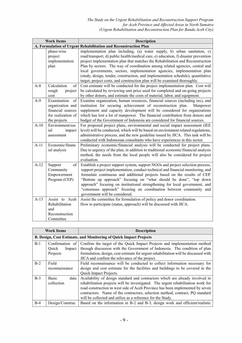
Work Items Description A. Formulation of Urgent Rehabilitation and Reconstruction Plan
phase-wise project implementation plan
implementation plan including, (a) water supply, b) urban sanitation, c) road/transport, d) public health/medical care, e) education, f) disaster prevention project implementation plan that matches the Rehabilitation and Reconstruction Plan by sectors. The way of coordination among related agencies, central and local governments, sectors, implementation agencies, implementation plan (study, design, tender, construction, and implementation schedule), quantitative target, project costs, and construction plan will be examined thoroughly.
A-8 Calculation of rough project cost
Cost estimate will be conducted for the project implementation plan. Cost will be calculated by reviewing unit price used for completed and on-going projects by other donors, and estimate the costs of material, labor, and equipment.
A-9 Examination of organization and financial sources for realization of the projects
Examine organization, human resources, financial sources (including tax), and institution for securing achievement of reconstruction plan. Manpower supplement and capacity development will be considered for organizations which has lost a lot of manpower. The financial contribution from donors and budget of the Government of Indonesia are considered for financial sources.
A-10 Environment/social impact assessment
For proposed project plans, environmental and social impact assessment (IEE level) will be conducted, which will be based on environment related regulations, administrative process, and the new guideline issued by JICA. This task will be conducted with Indonesian consultants who have experiences in this sector.
A-11 Economic/financial analysis
Preliminary economic/financial analysis will be conducted for project plans. Due to urgency of the plan, in addition to traditional economic/financial analysis method, the needs from the local people will also be considered for project evaluation.
A-12 Support of Community Empowerment Program (CEP)
Establish a project support system, support NGOs and project selection process, support project implementation, conduct technical and financial monitoring, and formulate continuous and additional projects based on the results of CEP. “Bottom up approach” focusing on “what should be done”, “top down approach” focusing on institutional strengthening for local government, and “consensus approach” focusing on coordination between community and government will be considered.
A-13 Assist to Aceh Rehabilitation and Reconstruction Committee
Assist the committee for formulation of policy and donor coordination. How to participate (status, approach) will be discussed with JICA.
Work Items Description
B. Design, Cost Estimate, and Monitoring of Quick Impact Projects B-1 Confirmation of
Quick Impact Projects
Confirm the target of the Quick Impact Projects and implementation method through discussion with the Government of Indonesia. The condition of plan formulation, design, cost estimate for urgent rehabilitation will be discussed with JICA and confirm the relevance of the project.
B-2 Field reconnaissance
Field reconnaissance will be conducted to collect information necessary for design and cost estimate for the facilities and buildings to be covered in the Quick Impact Projects.
B-3 Basic data collection
Availability of design standard and contractors which are already involved in rehabilitation projects will be investigated. The urgent rehabilitation work for road construction in west side of Aceh Province has been implemented by seven contractors. Name of the contractors, selection method, contract, PQ standard will be collected and utilize as a reference for the Study.
B-4 Design/Construc Based on the information in B-2 and B-3, design work and efficient/realistic

The Study on the Urgent Rehabilitation and Reconstruction Support Program for Aceh Province and Affected Areas in North Sumatra
(Urgent Rehabilitation and Reconstruction Plan for Banda Aceh City)
- 10 -
Work Items Description B. Design, Cost Estimate, and Monitoring of Quick Impact Projects
tion plan construction plan will be formulated. Design and construction experiences by other donors will also be referred.
B-5 Cost estimate Based on the result of item B-4, cost estimate will be conducted. The unit price will be determined based on experiences of other projects and the market price (considering uniqueness of Aceh: distance area, security).
B-6 Project monitoring
Construction progress will be monitored for the implemented projects to support the projects to be completed as scheduled.
B-7 Preparation of monitoring report
Monitoring results will be compiled as Monitoring Report and explained to the Government of Indonesia
Work Items Description
C. Establishment of ARRIS (Aceh Rehabilitation & Reconstruction Information System) C-1 Digital mapping Digital maps will be prepared by using SAR (Synthetic Aperture Rader) whose
data can be obtained from any weather condition and SAR data processing. Data can be obtained even before the end of the rain season, so digital mapping can be started immediately which satisfies urgent needs required for the Study. The contents of the digital mapping will be discussed and confirmed with relevant Ministries in Indonesia.
C-2 Establishment of ARRIS (Aceh Rehabilitation & Reconstruction Information System
ARRIS will be established by digitizing geographic information covering the disaster damage and reconstruction process, which is strongly linked with decision making for rehabilitation and reconstruction policy and project selection. Since quickness and urgency are required for the Study, formulation of information system will be implemented by two steps. Simplified ARRIS will be established (based on IKONOS satellite image), as a first step, to understand the present condition by comparing before and after conditions. Complete ARRIS will be established based, as a second step, on the damage condition and geographic data after the disaster (1/2,000) through IKONOS analysis. The data will be structured by sectors in rehabilitation and reconstruction projects, which can be used for decision making for rehabilitation and reconstruction policy.
Work Items Description
D-1 Preparation of Final Report (1)
Final Report (1) will be prepared based on the comments from the Government of Indonesia. The report will be finalized after discussing and receiving the comments from JICA.
D-2 Preparation of Final Report (2)
Final Report (2) will be prepared based on the comments from the Government of Indonesia. The report will be finalized after discussing and receiving the comments from JICA.
The Study on the Urgent Rehabilitation and Reconstruction Support Program for Aceh Province and Affected Areas in North Sumatra
(Urgent Rehabilitation and Reconstruction Plan for Banda Aceh City)
- 11 -
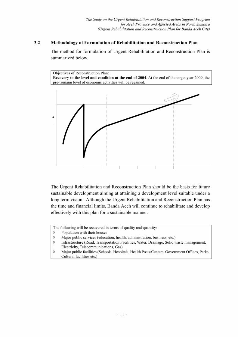
3.2 Methodology of Formulation of Rehabilitation and Reconstruction Plan
The method for formulation of Urgent Rehabilitation and Reconstruction Plan is summarized below.
Objectives of Reconstruction Plan: Recovery to the level and condition at the end of 2004. At the end of the target year 2009, the pre-tsunami level of economic activities will be regained.
The Urgent Rehabilitation and Reconstruction Plan should be the basis for future sustainable development aiming at attaining a development level suitable under a long term vision. Although the Urgent Rehabilitation and Reconstruction Plan has the time and financial limits, Banda Aceh will continue to rehabilitate and develop effectively with this plan for a sustainable manner.
The following will be recovered in terms of quality and quantity: ◊ Population with their houses ◊ Major public services (education, health, administration, business, etc.) ◊ Infrastructure (Road, Transportation Facilities, Water, Drainage, Solid waste management,
Electricity, Telecommunications, Gas) ◊ Major public facilities (Schools, Hospitals, Health Posts/Centers, Government Offices, Parks,
Cultural facilities etc.)
The Study on the Urgent Rehabilitation and Reconstruction Support Program for Aceh Province and Affected Areas in North Sumatra
(Urgent Rehabilitation and Reconstruction Plan for Banda Aceh City)
- 12 -
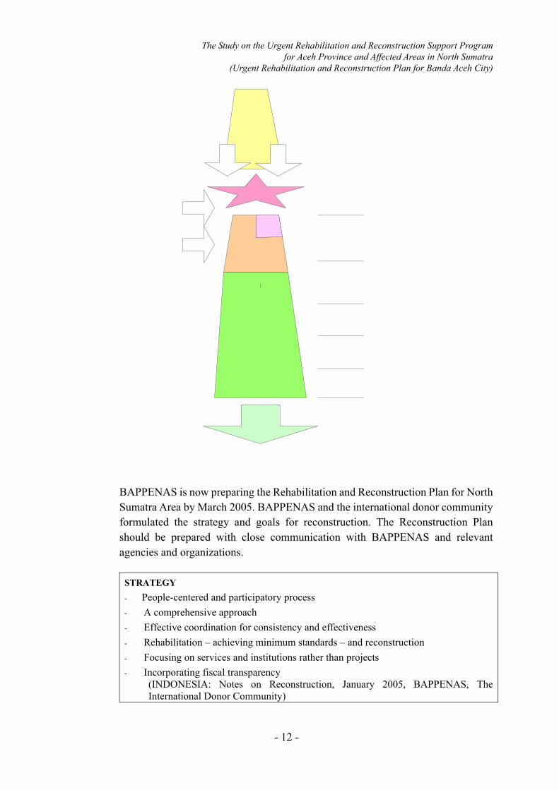
BAPPENAS is now preparing the Rehabilitation and Reconstruction Plan for North Sumatra Area by March 2005. BAPPENAS and the international donor community formulated the strategy and goals for reconstruction. The Reconstruction Plan should be prepared with close communication with BAPPENAS and relevant agencies and organizations.
STRATEGY - People-centered and participatory process - A comprehensive approach - Effective coordination for consistency and effectiveness - Rehabilitation – achieving minimum standards – and reconstruction - Focusing on services and institutions rather than projects - Incorporating fiscal transparency (INDONESIA: Notes on Reconstruction, January 2005, BAPPENAS, The
International Donor Community)
The Study on the Urgent Rehabilitation and Reconstruction Support Program for Aceh Province and Affected Areas in North Sumatra
(Urgent Rehabilitation and Reconstruction Plan for Banda Aceh City)
- 13 -
Objectives (Goals) - To restore people’s lives
clean water, roads, clinics, roofs over their head, a source of income to support their families
- To restore the economy – jobs, banks - To rebuild communities - To restore the system of local governance - To re-establish the province as a growth pole (INDONESIA: Notes on Reconstruction, January 2005, BAPPENAS, The
International Donor Community)
The Urgent Rehabilitation and Reconstruction Plan will be prepared with participatory approach with all stakeholders including communities/citizens, local government, central government, donors, NGOs and private sectors. - The Urgent Rehabilitation and Reconstruction Plan will be comprehensive and
integrated with all factors including economy, social (community, poverty etc.), environment, land use (zoning), traffic/transportation, infrastructure, organization, legislation/controlling mechanism, finance etc.
- The Urgent Rehabilitation and Reconstruction Plan will include Implementation Program (design, schedule, implementation body, responsible body, finance, environmental consideration) and a capacity development plan for sustainable development.

The Study on the Urgent Rehabilitation and Reconstruction Support Program for Aceh Province and Affected Areas in North Sumatra
(Urgent Rehabilitation and Reconstruction Plan for Banda Aceh City)
- 14 -
3.3 Establishment of Geographic Information System for Rehabilitation and Reconstruction of Banda Aceh
3.3.1 Objectives
In order to support the rehabilitation and reconstruction activities, a geographic information system and relevant digital maps and digital geospatial data will be prepared.
- A geographic information system (GIS) will be established and used for basic
urban planning in the city of Banda Aceh. The GIS, and the information will be owned and used by the people who are concerned with the rehabilitation and reconstruction for the city.

The Study on the Urgent Rehabilitation and Reconstruction Support Program for Aceh Province and Affected Areas in North Sumatra
(Urgent Rehabilitation and Reconstruction Plan for Banda Aceh City)
- 15 -
- Digital topographic maps and other geospatial data will be prepared and used with the system. The geographical data will be prepared at a nominal scale of 1:2,000.
- The GIS and associated data will be named “ARRIS”, which is an acronym for “Aceh Rehabilitation and Reconstruction Information System”.
3.3.2 General Work Flow
(1) Establishment of ARRIS
The workflow for establishing ARRIS is shown in figure below.
ARRIS SystemARRIS System
SAR Data processing・Image data processing・Interferometric processing・Ortho-rectification processing
Base Data-1; Topographic data Airborne SAR
Base Data-2; Land Surface data IKONOS satellite image
Ortho-rectification processing
DTM
Contour(2m)
Generation of GIS Data・Basic GIS data
(ex; Road, River, etc)・Extract of damaged feature
Image Analysis・Land cover map (before/after)・Extract of damaged area・Correlation of elevation and damaged area
Local survey collected information
GIS data structuring
ARRIS System Work Flow

The Study on the Urgent Rehabilitation and Reconstruction Support Program for Aceh Province and Affected Areas in North Sumatra
(Urgent Rehabilitation and Reconstruction Plan for Banda Aceh City)
- 16 -
(2) Preparation of Digital Maps
Digital maps and relevant geospatial data will be generated in this Project. The target area is Banda Aceh and surrounding areas, as shown in figure below.
Target Area of Data Preparation
Before starting the work, the Study Team will have meetings with Indonesian counterparts to decide the precise specifications for the GIS data and digital topographic maps.
The work flow for preparing the digital maps is shown in figure below.
Data Collection by Air born SAR・Installation of GPS base station・Installation of corner refractors
SAR signal conditioning
Topographic data
IKONOS Satellite Imagery・Ortho-ready Standard Imagery ・Panchromatic and Multispectral (R/G/B/IR)
・Ortho-rectification・Image Mosaicing・Sub-image Tile ・Pansharpening・Time series analysis
Land Surface data
・IFSAR; Interferometric SAR・Ortho-rectification
・Digital Mapping・Compilation Interpretation of Features Image Analysis
GIS data Scale ; 1:2,000 Work flow for Preparation of Digital Maps

The Study on the Urgent Rehabilitation and Reconstruction Support Program for Aceh Province and Affected Areas in North Sumatra
(Urgent Rehabilitation and Reconstruction Plan for Banda Aceh City)
- 17 -
Digital mapping will be carried out using a combination of airborne Synthetic Aperture Radar (SAR) technology and high resolution satellite imagery. Airborne SAR will be used to obtain ground elevation data which can be used to generate topographic maps. High resolution satellite imagery will be used to provide a base image for creating spatial data, such as mapping location of buildings before and after the Tsunami that occurred on December 26, 2004.
Airborne SAR will be used to generate elevation contours instead of conventional aerial photography and photogrammetric methods because the SAR data can be acquired in cloudy weather conditions that typically occur in the Banda Aceh area. Cloudy weather conditions would hinder airborne photographic missions and therefore delay the map production process.
The urgent need for preparation of digital maps and a GIS database for use in the rehabilitation and city planning of Banda Aceh can be met by combining airborne SAR and high resolution satellite imagery.
(a) Elevation Data
acquisition by airborne SAR
Airborne Synthetic Aperture Radar (SAR) uses radio waves that can pass through clouds, so data acquisition can be conducted in cloudy weather conditions. Airborne SAR can also be used at night. Radio waves are generated by a transmitter on board the aircraft, and these are beamed towards the ground surface. When the radio waves reach the ground, they are reflected back towards the aircraft. A receiver on board the aircraft detects the reflected waves. A computer is used to compare the transmitted and reflected radio waves. The height of the ground surface is determined by the computer using complex calculations. A map of ground elevation, including contours, can be produced from the processed radar data. Airborne SAR will be used to generate elevation data covering an area of approximately 350 km2. This area includes Banda Aceh city and the surrounding district. The expected ground pixel size (spatial resolution) is 1.25m. The expected horizontal positional accuracy is ±1.5m and the expected vertical accuracy is ±0.5m.. These data will allow detailed topographic maps to be prepared at a nominal scale of 1:2,000. These topographic maps will have a 2 meter contour interval.
(b) Ground Control Point (GCP) survey
Before the airborne SAR data are acquired, surveyors will make accurate position and height measurements at specific locations in Banda Aceh city and the surrounding area. These locations are known as ground control points (GCP’s). The GCP position and height information will be used later to correct the airborne SAR data so that the resulting topographic maps have the required horizontal and vertical accuracy. A Differential Global Positioning System (DGPS) will be used to assist

The Study on the Urgent Rehabilitation and Reconstruction Support Program for Aceh Province and Affected Areas in North Sumatra
(Urgent Rehabilitation and Reconstruction Plan for Banda Aceh City)
- 18 -
with making the GCP position and height measurements. The DGPS data will be complemented with surveyed coordinate data. A total of 29 GCP’s will be established in and around the Banda Aceh city. Surveyors will do both leveling and spot leveling in specific areas to ensure that the elevation data has an appropriate accuracy. Special ‘corner reflectors’ will be placed on the ground at each GCP location. The corner reflectors are fabricated from metal and are designed so that they strongly reflect SAR radio waves. The corner reflectors will be clearly identifiable in the SAR data. Detailed specifications for the GCP survey will be prepared after discussions are held with Indonesian counterparts.
(c) SAR data processing
The raw data acquired by the airborne SAR system represent measurements of the difference between the radio waves that are transmitted from the aircraft and the radio waves that are reflected back from the ground. These raw data do not look like an image, so they can not be interpreted easily. Therefore, these raw data must be processed by a computer so that a recognizable image of the ground surface can be seen. Additional processing is required to convert the ground surface image into a topographic map that shows elevation contours. Airborne SAR data processing consists of the following steps: 1) SAR Signal Conditioning
This process uses the aircraft navigation and attitude (X/Y/Z axis) data derived from the onboard differential GPS (DGPS) and the aircraft’s inertial navigation system (INS). These data allow a pair of raw SAR images acquired at the same time, but with slightly different parameters, to be co-registered. Once the SAR image pair is co-registered, the data are suitable for further processing.
2) IFSAR processing The co-registered SAR image pair (see above) is further processed using an Interferometric Synthetic Aperture Radar (IFSAR) processing system. This system utilizes an interferometric process to compare each of the images in the SAR image pair, and thereby generate ground surface elevation data. The output of this process is a Digital Surface Model (DSM). The DSM is a digital image that generally represents the height of the ground surface, but it also includes the height of objects such as trees and buildings. The DSM must be filtered by using a combination of automated and manual editing to produce a Digital Terrain Model (DTM). The DTM will correctly represent the height of the ground surface. However, further processing is required to ensure that the DTM image location correctly matches the ground surface.
3) DTM Ortho-Image Preparation The DTM image (see above) is accurately registered to the ground surface in this step. This is done by using the position and height data

The Study on the Urgent Rehabilitation and Reconstruction Support Program for Aceh Province and Affected Areas in North Sumatra
(Urgent Rehabilitation and Reconstruction Plan for Banda Aceh City)
- 19 -
recorded for the ground control points (GCP’s) that were laid out prior to the airborne SAR imagery being acquired, as described above. This allows the DTM to be corrected for both position and height. The output of this process is an ortho-rectified DTM (ortho-DTM). The ortho-DTM is now an accurate representation of the ground surface.
4) Contour Mapping The ortho-DTM (see above) is first edited to remove height anomalies, such as ‘pits’ and ‘spikes’. After these anomalies are removed, the elevation data can be converted to contour lines. This will be done using a fully automatic contour line generation process. The contour lines will have a similar appearance to the contours that are printed on standard paper topographic maps. However, as the contour interval is quite small (2 m) there will be many contour lines in hilly areas. An index contour line will be shown at 10 meter intervals. The contour line maps will provide engineers and planners with important information about both the height and shape of the ground surface. This will assist them when they design the rehabilitation and reconstruction works in Banda Aceh city.
(d)Ortho-Rectification of IKONOS High Resolution Satellite Imagery
The high resolution IKONOS satellite images that will be used for this Project were captured both before and after the Tsunami disaster that occurred on December 26, 2004. Two sets of images will be used so that a comparison of the ‘before’ and ‘after’ situation can be made. The IKONOS images will be georeferenced using the GCP’s that were used to make the ortho-DTM (see above), and also the edited ortho-DTM itself. This will produce ortho-rectified images (ortho-images) that correctly match both the actual land surface and the edited ortho-DTM. The ortho-images will be used as a reference base map for various field surveys to be conduced under this Project. In addition, the ortho-images will be used as background data from which various information or attributes can be extracted and loaded into ARRIS (Aceh Rehabilitation and Reconstruction Information System).
(e) Digital Mapping The IKONOS ortho-images will be loaded into an Engineering Workstation (Unix computer) that has been specially designed for digital mapping work. The digital mapping will be carried out by on-screen digitizing to extract features such as roads, rivers, buildings, etc. The nominal mapping scale will be 1:2,000. The vector lines created by the digital mapping process will be transferred to ARRIS (Aceh Rehabilitation and Reconstruction Information System).
(f) Supplementary Surveys
A supplementary survey will be carried out to collect necessary annotation information (names) for features mapped during the digital mapping process (see above). For example, the names of roads, rivers, bridges, railways, schools, villages, factories, public buildings, and

The Study on the Urgent Rehabilitation and Reconstruction Support Program for Aceh Province and Affected Areas in North Sumatra
(Urgent Rehabilitation and Reconstruction Plan for Banda Aceh City)
- 20 -
administrative areas will be collected. After completing the annotation process, an additional survey will be carried out to confirm that the annotations added to the digital map vectors are correct.
(g) GIS data structuring
Digital mapping data produced by the above processes will be structured so that it can be utilized in ARRIS. ARRIS will be built on a commercial Geographic Information System (GIS). The quality and reliability of the GIS data and digital maps shall be checked adequately by the Study Team.
The table below shows contents of the work that are planned in this study.
Contents of Work for Preparation of Digital Map and Relevant Data Work Item Outline of Work
- GCP reference point settings and related field survey
- DGPS survey, 29 points - Survey leveling, 210 km2 - Spot leveling 68 km2
- Airborne SAR data acquisition - 350km2 - Preparation of DTM - Preparation of contour map (2m pitch)
- Preparation of IKONOS satellite image -1 (before and after disaster)
- 350km2 - Preparation of ortho-rectified image - Image mosaic and sub-image tile preparation;
time series analysis - Preparation of GIS mapping
- Preparation of IKONOS satellite image -2- (250km* 5km, Along the road)
- 1+2; Total Area 1,300km2 - Image mosaic and sub-image tile preparation
- Annotation field survey - Local Contractor
- 1:2,000 Scale Digital Map production - 68 km2 - GIS base map, topographic data
- Structuring of GIS data base system - ARRIS Simplified Version - ARRIS Complete Version
A sample SAR image and a diagram showing the general concept of airborne SAR are shown in Figure below.
Sample SAR Image and Concept of Airborne-SAR

The Study on the Urgent Rehabilitation and Reconstruction Support Program for Aceh Province and Affected Areas in North Sumatra
(Urgent Rehabilitation and Reconstruction Plan for Banda Aceh City)
- 21 -
The GIS data and digital maps will be checked adequately by the Study Team.
(3) Establishment of ARRIS
ARRIS will be established in two stages. In the first stage, a simplified version of ARRIS will be established. In the second stage, a complete version of ARRIS will be established. The Study Team will transfer ARRIS-related technology to Indonesian counterparts.
1) ARRIS Simplified Version
The simplified version of ARRIS will be used by all persons concerned with the rehabilitation and reconstruction of Banda Aceh. It shall be used mainly to check the situation of the study area by using the satellite images acquired by the IKONOS satellite. The simplified version will remain active until the end of April, 2005. The satellite images will be processed so that they are suitable for use at a scale of 1:5,000. The data collected for the Project will be incorporated into ARRIS. The data and information that is to be used with the simplified version of ARRIS will be delivered on CD-ROM or by E-mail to persons concerned with the Project. In addition, an Internet web site will be built by the Study Team to disseminate information.
2) ARRIS Complete Version
The full version of ARRIS will be used as a decision-support system for planning the rehabilitation and reconstruction work, and also for urban planning in Banda Aceh. The full version of ARRIS will include all of the data prepared for the Project. These GIS data will be prepared at a nominal scale of 1:2,000. In addition, the full version of ARRIS will be linked to the Internet.
ARRIS systemdatabase server
Check the situations of the study areaARRIS system shall be delivered as CD-ROM to each sector
Used as a decision-making support systemARRIS system shall be access to the Internet Web site
ARRIS Simplified Version
Stand Alone System
Accsess to the Internet Web site
ARRIS Complete Version
ARRIS System Concept

The Study on the Urgent Rehabilitation and Reconstruction Support Program for Aceh Province and Affected Areas in North Sumatra
(Urgent Rehabilitation and Reconstruction Plan for Banda Aceh City)
- 22 -
Table GIS Data Set Prepared by Study Team Type of Data Set Scale or Resolution Contents, Specification, etc.
IKONOS Satellite Image 1.0m/Pixel Digital topographic map S=1:2,000 1m, 2m, 10m GIS Data set S=1:2,000 - Administrative boundary
- Roads - Railways - Buildings and structures - Landmarks - Water areas - Land use - Ground control points

The Study on the Urgent Rehabilitation and Reconstruction Support Program for Aceh Province and Affected Areas in North Sumatra
(Urgent Rehabilitation and Reconstruction Plan for Banda Aceh City)
- 23 -
CHAPTER 4 WORK SCHEDULE
4.1 Work Schedule
The Study starts from the middle of March, 2005 and to be completed in the end of March, 2006 (13 months). The work schedule is shown in Figure 2.
4.2 Report Schedule
Following reports will be prepared as the outputs of the Study:
Reports Submission date
Contents Number of Copy
(1) Inception Report Mid-March 2005 • Study Approach • Necessity of the study
and the Study outputs
(40)
(2) Final Report (1) August, 2005 • Urgent Rehabilitation and Reconstruction Plan
• Main Report (40) • Summary (40)
(3) Final Report (2) March, 2006 • Implementation of Urgent Rehabilitation Projects • GIS and ARRIS
• Main Report (20) • Summary (20)

The Study on the Urgent Rehabilitation and Reconstruction Support Program for Aceh Province and Affected Areas in North Sumatra
(Urgent Rehabilitation and Reconstruction Plan for Banda Aceh City)
- 24 -
CHAPTER 5 STAFF SCHEDULE
The Study Team comprises 21 members and a coordinator. Their names, positions, and assignment schedule are shown in Figure 3.
Name Position
<Urgent Rehabilitation and Reconstruction Plan/Donor Coordination Group> Akira TAKAHASHI Team Leader/Reconstruction Plan Yasushi SHIMANO Deputy Team Leader/Donor Coordination Yasumichi MIFUNE Disaster Mitigation Urban Plan Advisor Shouichiro MISAKI Coordinator/Urban Infrastructure <Urgent Rehabilitation and Reconstruction Plan Group> Naoyuki MINAMI Deputy Team Leader/Urban Planning Hideki SATO Land Use Plan Shigetaka MATSUBA Land Re-Adjustment Teddy Masanori KARTASASUMITA
Water Supply Plan
Maremori NOJIRI Urban Sanitation Plan Takeharu KOBA Road/Transport Plan Keiko NAGAI Public Health/Medical Care Plan Kyoichi SUGIYAMA Education Plan Yoshikimi INOUE Disaster Mitigation Plan Naoki HARA Community Development/Social Consideration Magdalena LUKOWSKA Community Development/NGO Coordination <GIS/ARRIS Group> Kenichi TANAKA GIS Kei SATO Aerial Photo Nobuhiro SATA Field Survey Yutaka KOKUFU Survey / Digital Mapping data edit Kyoko USUDA System Development <Quick Impact Projects Support Group> Isao INUZUKA Facility Plan/Design Iwao NAKAJIMA Architecture Plan 1/Design Kenji HIRAMATSU Architecture Plan 2/Plant Design Tetsuro IZAWA Cost Estimate/Procurement Plan 1 Yutaka IMAI Cost Estimate/Procurement Plan 2 Yasushi SHIMANO Project Monitoring 1 Seiji KIKUCHI Project Monitoring 2

The Study on the Urgent Rehabilitation and Reconstruction Support Program for Aceh Province and Affected Areas in North Sumatra
(Urgent Rehabilitation and Reconstruction Plan for Banda Aceh City)
- 25 -
CHAPTER 6 UNDERTAKING BY THE GOVERNMENT OF INDONESIA
A common objective between the Government of Indonesia and JICA is the successful accomplishment of the Study. In this respect, the Government of Indonesia will accord privileges, immunities and other assistance to the JICA Study Team:
1. To facilitate smooth conduct of the Study, the Government of Indonesia shall take necessary measures:
(1) To permit the members of the Team to enter, leave and sojourn in the Indonesia for the duration of their assignment therein, and exempt them from foreign registration requirements and consular fees,
(2) To exempt the members of the Team from taxes, duties, fees and any other charges on equipment, machinery and other materials brought into and out of the Indonesia for the conduct of the Study,
(3) To exempt the members of the Team from income tax and charges of any kind imposed on or in connection with any emoluments or allowances paid to the members of the Team for their services in connection with the implementation of the Study,
(4) To provide necessary facilities to the Team for the remittances as well as the utilization of the funds introduced into the Indonesia from Japan in connection with the implementation of the Study,
2. The Government of Indonesia shall bear claims, if any arise, against the members of the Team resulting from, occurring in the course of, or otherwise connected with the discharge of their duties in the implementation of the Study, except when such claims arise from gross negligence or willful misconduct on the part of the members of Team.
3. National Development Planning Agency (BAPPENAS) shall act as a counterpart agency to the Team and also as a coordinating body in relation with other government and non-government organization concerned for the smooth implementation of the Study.

Figure 1 Work Flow
1 year 2 year2005 2006
A Formulation of Urgent Rehabilitation and Reconstruction Plan
B Design/cost estimate/monitoring of Quick Impact Projects
Study Item
s
C Establishment of ARRISStudy Item
s
Reports
Study Item
s
MarchNov. Dec. Jan. Feb.July Aug. Sept. Oct.March April May June
▲
IC/R▲
F/R1▲
F/R2
【A-1】Examination of condition Part 1(Disaster)a) Population (including temporary shelter area)b) Land usec) Social infrastructure
【A-3】Analysis ofreconstruction direction
【A-4】Reconstructionframework
【A-6】Urban infrastructure & socialservices
【A-7】Phase-wise implementation
【A-9】Organizations & finance
【A-10】Environment & social impactassessment
【A-11】Economic & financial analysis
【A-12】 Support of Community Empowerment Program (CEP)
【A-13】Assist to Aceh Rehabilitation and Reconstruction Committee
【B-3】Data collection
【B-6】Project monitoring
【B-5】Costestimate
【B-7】Monitoring report
【C-1】Digital Mapping
【C-2】Establishment of ARRIS
【A-8】Cost estimate
【A-2】Examination of present condition (Part 2)a) Socio-economyb) Land use planc) Natural/Environmentd) Urban plane) Road/Transportf) Water supply/sanitationg) Public health/medical care/educationh) Mapsi) Organizations and institutions /technical level for urban planj) Finance for urban developmentk) Laws and regulations
【A-5】Land use planformulation
【B-1】Confirmationof projects
【B-2】Fieldreconnaissance
【B-4】Design/implementation plan
a) Systemize formulation of communityneeded projectsb) Support of project announcement,selection process c) Project implementation process
d) Reportinge) Formulation ofprojects

Figure 2 Work Plan
1st Year 2nd Year2005 2006
A Formulation of Reconstruction Master Plan
【A-1】 Examination of present condition (part 1) (Disaster condition)*1)
a) Population (including temporary shelter area)
b) Land usec) Social infrastructure (road/transport, water supply, sanitation, publichealth/medical care, education, etc.)
【A-2】 Examination of present condition (part 2)a) Socio-economic condition (economic activity, population trend,education, employment, industry, etc.)
b) Land use plan
c) Natural and environmental conditions
d) Plans and projects for urban development
e) Road and transport (plans and description)
f) Water supply/sanitation (plans and description)
g) Public health/medical care (plans and description)
h) Existing mapsi) Urban plan/development and its authority, management, technicallevel
j) Budget for urban development
k) Laws and regulations
【A-3】 Analysis of reconstruction issues and setting of reconstruction policy
【A-4】 Formulation of framework for Reconstruction Plan
【A-5】 Formulation of land use plan
【A-6】Formulation of urban infrastructure and social services rehabilitation andreconstruction plan
【A-7】 Formulation of phase-wise project implementation plan
【A-8】 Calculation of rough project cost
【A-9】Examination of organization and financial sources for realization of theprojects
【A-10】 Environment/social impact assessment
【A-11】 Economic and financial analysis
【A-12】 Support of Community Empowerment Programs (CEP)*2)
a) Systemize the process for formulation of projects needed by the localpeople
b) Support of project announcement, evaluation and selectionc) Support of project implementation (fund, progress management,accounting, evaluation)
d) Auditing of final report and financial report
e) Formulation of technical cooperation programs
【A-13】 Assist to Aceh Rehabilitation and Reconstruction Committee *2)
【A-14】 Preparation of Final Report (1)
B Design/cost estimate/monitoring of Quick Impact Projects
【B-1】 Confirmation of Quick Impact Projects
【B-2】 Field reconnaissance
【B-3】 Basic data collection
【B-4】 Design/construction plan
【B-5】 Cost estimate
【B-6】 Project monitoring
【B-7】 Preparation of monitoring report
C Establishment of Aceh Rehabilitation & Reconstruction Information System (ARRIS)
【C-1】 Digital mapping
a) Data acquisition by airborne SAR
b) SAR data processing SAR
c) Ground Control Point (GCP) survey and Signaling/Monumentation
d) Ortho conversion of IKONOS high resolution satellite image
e) Field survey
f) DTM (Digital Terrain Model) production
g) Contour line preparation
h) Digital mapping
i) Local catching survey
j) GIS data structuring
【C-2】 Establishment of ARRIS
a) Establishment of ARRIS simplified version
b) Establishment of ARRIS Complete Version *2)
【C-2】 Preparation of Final Report (2)
Reports
*1)Conducted continuously during the Reconstruction Master Plan preparation stage
*2)Conducted continuously during the Study execution period.
MarchNov. Dec. Jan. Feb.July Aug. Sept. Oct.March April May June
▲
IC/R▲
F/R1▲
F/R2
F-2