the tectonics and active faulting of haiti from seismicity
TRANSCRIPT

HAL Id: hal-02325390https://hal.archives-ouvertes.fr/hal-02325390
Submitted on 25 Nov 2020
HAL is a multi-disciplinary open accessarchive for the deposit and dissemination of sci-entific research documents, whether they are pub-lished or not. The documents may come fromteaching and research institutions in France orabroad, or from public or private research centers.
L’archive ouverte pluridisciplinaire HAL, estdestinée au dépôt et à la diffusion de documentsscientifiques de niveau recherche, publiés ou non,émanant des établissements d’enseignement et derecherche français ou étrangers, des laboratoirespublics ou privés.
The Tectonics and Active Faulting of Haiti fromSeismicity and Tomography
Daniel Possee, Derek Keir, Nicholas Harmon, Catherine Rychert, FrédériqueRolandone, Sylvie Leroy, Jordane Corbeau, Graham Stuart, Eric Calais,
Finnigan Illsley-kemp, et al.
To cite this version:Daniel Possee, Derek Keir, Nicholas Harmon, Catherine Rychert, Frédérique Rolandone, et al.. TheTectonics and Active Faulting of Haiti from Seismicity and Tomography. Tectonics, American Geo-physical Union (AGU), 2019, 38 (3), pp.1138-1155. �10.1029/2018TC005364�. �hal-02325390�

The Tectonics and Active Faulting of Haiti from Seismicityand TomographyDaniel Possee1 , Derek Keir1,2 , Nicholas Harmon1 , Catherine Rychert1 ,Frédérique Rolandone3 , Sylvie Leroy3 , Jordane Corbeau3,4 , Graham Stuart5,Eric Calais6 , Finnigan Illsley‐Kemp1,7 , Dominique Boisson8, Roberte Momplaisir8, andClaude Prépetit9
1Ocean and Earth Science, National Oceanography Centre, University of Southampton, Southampton, UK, 2Dipartimentodi Scienze della Terra, Università degli Studi di Firenze, Florence, Italy, 3Sorbonne Université, CNRS‐INSU, Institut desSciences de la Tere Paris (iSTeP), Paris, France, 4IPGP, Observatoire de la Martinique, Paris, France, 5School of Earth andEnvironment, University of Leeds, Leeds, UK, 6Ecole normale supérieure, Department of Geosciences, Université PSL,Paris, France, 7School of Geography, Environment and Earth Sciences, Victoria University of Wellington, Wellington,New Zealand, 8Faculté des Sciences, Université d'Etat d'Haiti, Port‐au‐Prince, Haiti, 9L'Unité Technique de Sismologie(UTS)/BME, Port‐au‐Prince, Haiti
Abstract Oblique convergence of the Caribbean and North American plates has partitioned strain acrossa major transpressional fault system that bisects the island of Hispaniola. The devastating MW 7.0, 2010earthquake that struck southern Haiti, rupturing an unknown fault, highlighted our limited understandingof regional fault segmentation and its link to plate boundary deformation. Here we assess seismic activityand fault structures across Haiti using data from 33 broadband seismic stations deployed for 16 months. Weuse traveltime tomography to obtain relocated hypocenters and models of Vp and Vp/Vs crustal structure.Earthquake locations reveal two clusters of seismic activity. The first corresponds to aftershocks of the2010 earthquake and delineates faults associated with that rupture. The second cluster shows shallowactivity north of Lake Enriquillo (Dominican Republic), interpreted to have occurred on a north‐dippingthrust fault. Crustal seismic velocities show a narrow low‐velocity region with an increased Vp/Vs ratio(1.80–1.85) dipping underneath the Massif de la Selle, which coincides with a southward‐dipping zone ofhypocenters to a depth of 20 km beneath southern Haiti. Our observations of seismicity and crustal structurein southern Haiti suggests a transition in the Enriquillo fault system from a near vertical strike‐slip faultalong the Southern Peninsula to a southward‐dipping oblique‐slip fault along the southern border of theCul‐de‐Sac‐Enriquillo basin. This result, consistent with recent geodetic results but at odds with the classicalseismotectonic interpretation of the Enriquillo fault system, is an important constraint in our understandingof regional seismic hazard.
1. Introduction
The oblique convergence of the Caribbean and North American plates at 19 mm/year has resulted in a trans-pressive fault system that affects the island of Hispaniola (Haiti and Dominican Republic; Calais et al., 2016).Previous geophysical studies into crustal structure have mainly focused on the epicentral region of the Mw
7.0, 12 January 2010 Haitian earthquake, revealing a network of subsurface faults which accommodatesstrain across the broader fault zone (Calais et al., 2010; Douilly et al., 2013; Wang et al., 2018). Regional crus-tal structure across Haiti has also been constrained by the use of receiver functions (Corbeau, Rolandone,et al., 2017).
The 2010 Haiti earthquake highlighted the importance of understanding crustal structures in seismic hazardassessment. Prior to the event, there was no knowledge of the Léogâne fault, the main fault which ruptured,with regional fault slip models only being able to incorporate a single vertical strike‐slip fault, the Enriquillo‐Plantain Garden Fault (EPGF, Figure 1; Manaker et al., 2008). Only through inversions of ground motiondata recorded during the 2010 earthquake was the oblique rupture on the Léogâne fault recognized(Calais et al., 2010; Symithe et al., 2013) and later confirmed by precise aftershock relocations (Douillyet al., 2013). While the 2010 Haiti earthquake led to a vast improvement in our understanding of the regionalseismotectonics, historical records indicate this is not the only region on the island capable of producing adevastating earthquake (Figure 1; Bakun et al., 2012; Prentice et al., 2010; ten Brink et al., 2011).
©2019. American Geophysical Union.All Rights Reserved.
RESEARCH ARTICLE10.1029/2018TC005364
Key Points:• Local earthquake tomography and
hypocenter relocation wasperformed using seismicity acrossHaiti from 2013–2014
• Continued seismic activity wasobserved along Haiti's SouthernPeninsula, associated with faultsthat ruptured during the Mw 7.02010 earthquake
• Hypocenters and a low velocity zoneobserved beneath the Massif de laSelle suggest a major south dippingthrust structure
Supporting Information:• Supporting Information S1
Correspondence to:D. Possee,[email protected]
Citation:Possee, D., Keir, D., Harmon, N.,Rychert, C., Rolandone, F., Leroy, S., etal. (2019). The tectonics and activefaulting of Haiti from seismicity andtomography. Tectonics, 38, 1138–1155.https://doi.org/10.1029/2018TC005364
Received 9 OCT 2018Accepted 22 FEB 2019Accepted article online 5 MAR 2019Published online 29 MAR 2019
POSSEE ET AL. 1138

The aim of this paper is to use the Trans‐Haiti seismic network to analyze local earthquakes, determininghypocenter locations, a local magnitude scale, and 2.5‐D crustal models for P wave velocity (Vp) and Vp/Vs ratios. The spatial coverage of the Trans‐Haiti network, consisting of 27 temporary broadband seism-ometers, provides an excellent opportunity to assess both the distribution of seismicity 3 years after the2010 Haitian earthquake and crustal structure at a regional scale across Haiti. This is crucial for understand-ing how the crust is modified by active tectonics and for future hazard assessment.
1.1. Tectonic Setting
Geological and geophysical studies have shown that Haiti is formed from three distinct tectonic domains(Figure 1). Northern Haiti is part of the Great Arc of the Caribbean, which initially formed by subductionalong an inter‐American transform fault at ~135 Ma during the Cretaceous (Burke, 1988; Hastie et al.,2013; Pindell et al., 2012). During the eastward movement of the Caribbean plate, the Great Arc becameinactive toward the end of the Upper Cretaceous, subsequently colliding with the Bahamas carbonate plat-form and fragmenting to form the Greater Antilles islands (Cuba, Jamaica, Hispaniola, Puerto Rico, andVirgin Islands; Cruz‐Orosa et al., 2012; Hastie et al., 2013; Leroy et al., 2000; Mann et al., 1995). It has beenestimated that the Great Arc constitutes two thirds of Hispaniola and consists of dominantly volcanic arc andforearc‐accretionary prism facies (Mann et al., 1991).
The southern tectonic domain of Haiti is part of the Caribbean Large Igneous Province (CLIP), whichconsists of the Caribbean oceanic plateau and magmatic terranes along the Pacific coast of CentralAmerica and western Columbia, associated with the initiation of the Galapagos hotspot in the mid‐Cretaceous (Duncan & Hargraves, 1984; Geldmacher et al., 2003; Pindell, 1990). The CLIP outcrops onthe Southern Peninsula of Haiti and has been geophysically imaged south and west of Haiti (Calmus,1983; Corbeau, Rolandone, Leroy, Mercier de Lépinay, et al., 2016; Leroy et al., 2000; Mauffret &Leroy, 1997; Mauffret et al., 2001). The presence of the CLIP is consistent with elevated Vp/Vs ratios of~1.80, which are typical for mafic crustal rocks, seen in velocity models from local earthquake tomogra-phy (Douilly et al., 2016) and P‐to‐S receiver functions (Corbeau, Rolandone, et al., 2017) along theSouthern Peninsula of Haiti.
Figure 1. Tectonic map of Hispaniola (Haiti and Dominican Republic). Regional map in top left shows the relativemotionof the Caribbean plate (Ca) and North American plate (NA). Circles show previous seismicity catalogs for Haiti:blue = Douilly et al. (2013); gray = National Earthquake Information Centre. Stars represent major historic earthquakes(Bakun et al., 2012; Prentice et al., 2010). Tectonic domains after Corbeau, Rolandone, et al. (2017): CLIP = CaribbeanLarge Igneous Province (blue); THB = Trans‐Haiti deformation belt (brown); GAC = Greater Antilles Arc (purple).CSE=Cul‐de‐Sac‐Enriquillo basin. Black lines show the surface trace of major faults: EPGF=Enriquillo‐Plantain Gardenfault zone; SOFZ = Septentrional‐Oriente fault zone; LPSJFZ = Los Posoz‐San Juan fault zone; TBF = Trois Baies Faultsystem; LA = Lake Azuei, LE = Lake Enriquillo.
10.1029/2018TC005364Tectonics
POSSEE ET AL. 1139

The central domain is a collisional wedge between the CLIP and Great Arc of the Caribbean, which beganforming in the Early Miocene (Pubellier et al., 1991). As a result, it is characterized by a significantly thickerregion of 40‐km‐thick crust, compared to 20–30 km thick for the northern and southern domains (Corbeau,Rolandone, et al., 2017). Geological studies have indicated the crust in this domain is of island arc origin,with either a back‐arc or Cretaceous‐Eocene remnant arc origin (Heubeck et al., 1991; Mann et al., 1991).P‐to‐S receiver function analysis found this thick central domain to have a mean Vp/Vs of 1.80 (Corbeau,Rolandone, et al., 2017). This was inconsistent with a purely island arc crust; therefore, Corbeau,Rolandone, et al. (2017) inferred the presence of dense material, which they interpreted to be related toeither, Quaternary volcanics generated from a subcontinental lithospheric mantle (Kamenov et al., 2011)or mafic CLIP material from the south trapped in central Haiti early in its evolution.
1.2. Faulting
Haiti is bisected by twomajor left‐lateral strike‐slip faults, the Septentrional‐Oriente fault zone (SOFZ) in thenorth, which has been mapped offshore (Calais & Mercier de Lépinay, 1995; Leroy et al., 2015; Rodríguez‐Zurrunero et al., 2019), and the EPGF in the south (Figure 1; Mann et al., 1995). Between these faults, thefold and thrust belt, known as the Trans‐Haiti belt and active in the Miocene and Pliocene, controls muchof the relief on Haiti (Pubellier et al., 1991). It extends westward, forming the Gonâve Island as well as trans-pressive structures offshore (Corbeau, Rolandone, Leroy, Meyer, et al., 2016; Granja‐Bruña et al., 2014), andeastward up to the Muertos Trough (Byrne et al., 1985; Ladd et al., 1977). South of Gonâve Island, there is aseries of southward dipping faults extending 50 km, known as the Trois Baies thrust system (Mercier deLépinay et al., 2011; Momplaisir, 1986; Wang et al., 2018).
Initial slip models for theMw 7.0, 2010 Haitian earthquake indicated the rupture initiated on a south dippingEPGF (Hashimoto et al., 2011; Hayes et al., 2010). However, recent consensus has switched to an obliquerupture on a north dipping structure, interpreted to be the Léogâne fault, that intersects the south‐dippingEPGF at depth (Calais et al., 2010; Douilly et al., 2013). This hypothesis explained the lack of surface rupture,aftershock patterns, and shoreline uplift and was later supported by slip models of the rupture (Douilly et al.,2015; Hayes et al., 2010; Kocel et al., 2016; Saint Fleur et al., 2015; Symithe et al., 2013). Aftershocks clusteredon both the EPGF, Léogâne fault and Trois Baies fault system (Douilly et al., 2013; Mercier de Lépinay et al.,2011), which was consistent with static slip models and Coulomb stress changes (Douilly et al., 2015; SaintFleur et al., 2015). Focal mechanisms from aftershocks also indicated mostly reverse faulting onWNW‐ESE‐oriented faults dipping south at 30–40° (Nettles & Hjörleifsdóttir, 2010). The 2010 rupture therefore high-lighted that the mode of faulting in southern Haiti is not simply a near vertical strike‐slip fault system.Instead, there are many structures oblique to the main EPGF trace, which also have shallower dips andappear to me more seismically active.
The EPGF is well‐expressed offshore west of Haiti and shows a clear trace in the surface morphology onHaiti's Southern Peninsula (Bourgueil et al., 1988; Cowgill et al., 2012; Prentice et al., 2010; Wessels et al.,2019). However, its surface expression is much less clear eastward of where the fault intersects the Cul‐de‐Sac‐Enriquillo (CSE) basin (Figure 1, 72.3°W). Early geological work mapped the EPGF as terminatingagainst reverse faults bounding the southern edge of the CSE basin (Bourgueil et al., 1988). Cowgill et al.(2012) more recently observed a left‐lateral offset in the EPGF at a site to the east of Port‐au‐Prince, at theboarder of the CSE basin. In the CSE basin, Mann et al. (1995) and Wang et al. (2018) described curvilinearen echelon drag folds and interpreted them to mark the surface trace of the EPGF cross cutting the basin.East‐west linear structures observed in chirp sonar profiles from Lake Azuei and Lake Enriquillo have alsobeen used to interpret the presence of the EPGF crossing the CSE basin (Rios et al., 2013; Wang et al., 2018).
Saint Fleur et al. (2015) used air photographs and LIDAR topography to suggest that some of the folds in theCSE basin are fault propagation folds over shallow décollements, rooted on a major south‐dipping reversefault beneath the Massif de la Selle. GPS data are also fit better by elastic strain accumulation on a south‐dipping fault plane along the southern border of the CSE basin rather than a vertical fault cross cutting it,which results in 9 mm/year of reverse slip and 6 mm/year of strike slip motion (Symithe & Calais, 2016).Seismicity has also been observed south of the CSE basin with a predominantly thrust component to themoment tensors, and a mean P axis consistent with the NNE‐SSW compression orientation (Rodriguezet al., 2018). These observations are consistent with recent geological surveys that show the reverse faults,which border the CSE basin, affecting Quaternary alluvial sediments in the city of Port‐au‐Prince area
10.1029/2018TC005364Tectonics
POSSEE ET AL. 1140

and to the east (Terrier et al., 2014). It seems therefore that while there may be evidence that the EPGF existsas a vertical structure across the CSE basin, present day motion is mainly accommodated along either one ora series of southward‐dipping thrust faults along the southern border of the CSE basin.
2. Methods2.1. Data
In April 2013, a temporary network of 27 broadband seismometers was deployed as part of the Trans‐Haitiproject (Figure 2). Most stations were deployed along a north‐south transect across the island with a spacingof approximately 5–10 km. Continuous seismic data were recorded over a 16‐month period at a samplingrate of 100 samples per second at all stations. Given the linearity of the network, E‐W spatial coveragewas improved by the addition of six permanent stations that were active at the same time as the temporarydeployment (Figure 2 and supporting information Table S1). Data for these stations were downloaded fromthe Incorporated Research Institutions for Seismology (IRIS). Due to high anthropogenic noise levels at moststations, the highest signal‐to‐noise ratio was achieved using a four‐pole Butterworth band‐pass filter withcorner frequencies at 1 and 6 Hz. This filter was applied to all stations prior to the manual picking of Pand S phase arrivals. This created an initial data set of 1,055 local earthquakes that was used in this study.
2.2. 1‐D Velocity Inversion
Previously derived velocity models for Haiti are limited to the immediate crustal region around the 2010Haitian earthquake on the Southern Peninsula (Douilly et al., 2013; Douilly et al., 2016). However, thereis likely to be strong lateral variation in seismic velocities between the tectonic domains as shown by the het-erogeneous Vp/Vs ratios measured by receiver functions at the Tran‐Haiti network stations (Corbeau,Rolandone, et al., 2017). We therefore derive new velocity models to account for these differences.
We use the VELEST code to invert P and S wave travel times for velocity models, station corrections, andhypocenter locations (Kissling et al., 1994). The method iteratively minimizes the root mean square(RMS) travel time residuals by changing velocities in layers that are specified by the user. We define the velo-city layers to be optimal for the subsequent tomographic inversion of the data; velocities are thereforeallowed to vary at −2, 0, 2, 4, 8, 12, 16, 20, and 24 km. An additional fixed velocity layer is added at 40 kmfor model stability; this depth is chosen based on the deepest Moho depth found by a receiver function study(Corbeau, Rolandone, et al., 2017). To ensure a stable inversion, we only use events with aminimum of five Pphases, five S phases, and an azimuthal gap of less than 240°. This high‐quality subset of the data consists of201 earthquakes with 1,603 P phase and 1,885 S phase arrival times.
We evaluate three different starting 1‐D velocity models for the inversion to test convergence and ensure ourfinal model is not significantly biased by the starting parameters. These include models for southern Haiti(Douilly et al., 2013), Cuba (Moreno et al., 2002), and Jamaica (Wiggins‐Grandison, 2004). The initial modelfor each inversion was interpolated from these models and extended to the Moho depth of 40 km using theak‐135 global model (Kennett et al., 1995). Initial inversions were used to test crustal structure and define avelocity model that best minimized RMS travel time residuals in the data. In these tests we did not invert forstation corrections. In the final stage, we selected the best fitting velocity model and performed a final inver-sion, including station corrections, to produce the final 1‐Dmodel that best minimized RMS travel time resi-duals, termed a minimum 1‐D model.
2.3. Earthquake Relocations
Using the minimum 1‐D velocity model, hypocenter locations for the full catalog of 1,055 local earthquakewere determined using the nonlinear NonLinLoc algorithm (Lomax et al., 2000). The algorithm computes aposterior density function (PDF) that represents a probability‐derived solution to the inverse problem ofearthquake location. The 1‐D model is used to calculate travel times between all stations and nodes on a3‐D grid for the search region. Locations are then determined for each event using an Oct‐Tree samplingalgorithm, which successively searches over the PDF by subdividing cells increasingly finer until a termina-tion criterion is reached. This generates complete earthquake location PDFs in 3‐D space for thesearch volume.
10.1029/2018TC005364Tectonics
POSSEE ET AL. 1141

2.4. Magnitudes
Accurate magnitude determination is essential for assessing seismic hazard in any particular region. Todetermine local magnitudes (ML) for the earthquakes in our catalog, we use a new local magnitude scalebased on the original definition by Richter (1935) and updated scale of Hutton and Boore (1987), whichnormalizes the scale at 17 km for an amplitude of 10 mm for a ML 3.0 earthquake.
log Að Þ þ 2 ¼ −n logr17
� �−K r−17ð Þ þML−S (1)
where A is equal to the measured amplitude, r is the hypocentral distance, S is an empirical station correc-tion factor, while n and K are constants related to geometrical spreading and attenuation of seismic waves. Inthe new local magnitude scale, we derive, n = 0.90137 and K = 0.0036789 using the inversion procedure ofIllsley‐Kemp et al. (2017; Figure S1). For more information on how these constants were obtained, seeSupporting Information S1.
In addition, seismic moments (Mo) are estimated for each earthquake. There is no local ML‐Mo scale deter-mined for the region; therefore, we assumed a 1:1 conversion from ML to Mb (body wave magnitude) andthen used a global empirical relationship to convert Mb to Mo (Scordilis, 2006).
2.5. Seismic Tomography
We used the SIMULPS code, which performs the tomographic inversion iteratively using a damped least‐squares approach (Eberhart‐Phillips, 1990; Thurber, 1983; Thurber & Eberhart‐Phillips, 1999; Um &Thurber, 1987). The code jointly inverts for hypocentral locations and velocity models on up to a full 3‐Dgrid, where Vp and Vp/Vs values are calculated at each grid node and linearly interpolated between nodes.
For the starting Vp model, we use the minimum 1‐D model determined in this study. For the starting Vp/Vs
model, we choose to use a constant value of 1.77, calculated using the gradient of the best‐fit line through a
Figure 2. Station distribution and model parameterization of the SIMULPS tomographic inversion. Black lines are theevent‐receiver raypaths, and the central row of blue nodes corresponds to the final profile analyzed in this study.Inverted triangles represent the seismic stations. The other island stations refer to seismic stations from the CanadianSeismic Network, United States Geological Survey, Centro Nacional de Sismologia, and the Greater Antilles SeismicProgram active at the same time as the Trans‐Haiti Network.
10.1029/2018TC005364Tectonics
POSSEE ET AL. 1142

Wadati diagram. In this way, we avoid as much bias in the starting model as possible. Events were selectedfrom the NonLinLoc catalog located using the minimum 1‐Dmodel. To maximize the spatial coverage of theinversion, additional events were included compared to the 1‐D inversion, extending the maximumazimuthal gap to 270°. In total, 437 events with robust location were selected, meaning they had a meanRMS travel time residual of less than 1 s and a minimum of six phases picked at more than five stations.The final inversion consisted of 4,843 manually picked seismic phases (2,619 P phases and 2,224 S phases)at 30 seismic stations.
In SIMULPS model, parameterization should be in part defined by the average station spacing and distribu-tion. Our linear station distribution is not ideal for a full 3‐D tomographic inversion. We therefore optimizeour inversion procedure to assess the lateral variation in seismic velocities along the NNE‐SSW profile,which is approximately perpendicular to the major tectonic domains and faults that form Hispaniola. Weparameterize the model with a N‐S horizontal node spacing of 12 km and a vertical node spacing of 4 km(Figure 2). For increased stability and to remove any off‐structure influences on the final 2‐D profile, addi-tional nodes were added to the east and west at a spacing of 50 km to the main profile (Figure 2). We there-fore refer to this a 2.5‐D inversion from this point onward. In total, the main profile of the model consisted of273 Vp and 273 Vp/Vs nodes along with 60 parameters pertaining to station corrections.
To prevent overfitting of the data, damping values were selected using a trade‐off curve between datavariance and model variance after a single iteration. For the final model, a value of 500 for both Vp andVp/Vs models showed a good compromise between data misfit and model complexity (Figure 3).
The SIMULPS code offers several quantitative methods by which to assess spatial resolution within themodel space. These include the derivative weight sum, which is a measure of ray density at each node,and the resolution diagonal element (RDE), which measures the dependency of the solution on individualmodel parameters. In addition, we also performed checkerboard resolution tests to assess the reliabilityand spatial resolution of the data. Checkerboard tests were performed by perturbing the model with ±10%Vp and Vp/Vs anomalies. This model was then used to generate synthetic travel times for each event‐receiverpair. Random noise was then added to the arrival times with standard deviation of 0.2 s. The velocity modelwas then forgotten, and the synthetic data inverted to recover the anomalies using the same parameters asthe final model.
3. Results3.1. 1‐D Velocity Model
The three starting velocity models from southern Haiti (Douilly et al., 2013), Cuba (Moreno et al., 2002), andJamaica (Wiggins‐Grandison, 2004) had a mean RMS travel time residual of 0.74, 1.30, and 0.96 s, respec-tively, which reduced to 0.41, 0.40, and 0.43 s after the first inversion without station residuals. All modelsshowed good convergence (Figure 4a); however, local minima in the RMS solution space were likely respon-sible for all models not reaching a single global minimum. As expected, the starting model from southernHaiti resulted in the best fitting velocity model for the data, with the best distribution of RMS travel time resi-duals (Figure 4c). The output of this model was therefore used as the starting model for the final inversion,
Figure 3. Trade‐off curves for the reduction of data variance versus increase in model variance. Blue circles represent thevalues after one iteration of the inversion for different damping values, ranging from 10 to 10,000. The red circles representthe optimum damping values for both the Vp and Vp/Vs models, which were used in the final inversion.
10.1029/2018TC005364Tectonics
POSSEE ET AL. 1143

including station corrections, to produce the minimum 1‐Dmodel (Figure 5 and Table 1). Theminimum 1‐Dmodel, with station corrections (Table S1), had a final mean RMS of 0.33 s, again an improvement on theprevious model in the inversion procedure.
3.2. Tomography3.2.1. ResolutionResolution estimates using the checkerboard approach showed good recovery of velocity perturbations witha cell size of 30 × 10 km within the central and southern regions of the model (Figure 6). There is good reso-lution to depths of 30 km in the Vpmodel and to 25 km in the Vp/Vsmodel. Amplitude recovery for the inputanomalies is good within the well‐resolved region; from the 10% input anomalies, the maximum recoveredanomalies are 10% and 6% for the Vp and Vp/Vs models, respectively. To the north of the well‐resolvedregion, there is smearing of velocity anomalies, due in part to the linearity of the seismic network and lackof crossing raypaths in the northern region of the model space.
The well‐resolved region of the checkerboard model also coincides with the 0.1 RDE contour. We thereforechoose a RDE value of 0.1 to approximate the maximum extent of resolution in the final models. The 15 × 7km checkerboard cell test demonstrates the ability to recover smaller anomalies in the central and southernregion of the model (Figure 7). However, smearing of velocity anomalies is still prevalent in the northernpart of the model space. In addition, the amplitude recovery of anomalies is reduced with maximum anoma-lies recovered being 6% for the Vp model and 4% for the Vp/Vs model.3.2.2. Model PerformanceThe final velocity model showed a decrease in RMS from 0.29 to 0.20 s over 10 iterations of the inversion.This represents a reduction in the model misfit by 31% over the starting model. Figure 8 shows cross
Figure 4. Results from the VELEST 1‐D inversion without station corrections. (a) Velocity models for the three startingmodels from southern Haiti (Douilly et al., 2013), Cuba (Moreno et al., 2002), and Jamaica (Wiggins‐Grandison, 2004).Dotted lines represent the input models and solid lines the output models. (b) Depth distribution of seismicity used in theinversion. (c) Distribution of root mean square (RMS) travel time residuals for the three output models.
10.1029/2018TC005364Tectonics
POSSEE ET AL. 1144

sections through the final Vp and Vp/Vs models along the primary profile,which corresponds to the central line of nodes in the inversion (Figure 2).As shown in the resolution test, the 0.1 RDE contour marks the outer limitof the well‐resolved model space, which extends beneath the land surfaceof Haiti (−80 to 80 km in the model space) and to depths of 25 km beneathsouthern Haiti.3.2.3. Vp ModelMultiple low‐velocity anomalies, with a 5–8% decrease in Vp comparedto the starting model, are present in the top 5 km of the crust alongthe profile (Figures 8 and 9). These anomalies correspond to the majorsedimentary basins (CSE, Artibonite, and Plateau Central basins), whichare identified by the regions of low‐lying topography along the profile.Between these basins, mountainous regions such as the Massif de laSelle and Montagnes Noires have higher Vp values. Deeper in the crust,at depths of 5–25 km, Vp is still laterally heterogeneous. High Vp valuesare generally present beneath the Massif de la Selle and CSE basin.However, a low‐velocity zone, with a 3–5% decrease in Vp, can be seenextending from the southern border of the CSE basin to a depth of15 km. Equally, to the north of the CSE basin, another large low‐velocity zone, with a 5–7% decrease in Vp, is present to a depthof 20 km.3.2.4. Vp/Vs ModelHigh Vp/Vs values of >1.80 are recovered for the upper 10 km of the crustfor most of the resolved region of the model in the southern half of themodel space (Figure 9). The largest anomaly is observed at the southernboundary of the CSE basin, with Vp/Vs values of 1.85–1.90. In the lower
crust at depths of 10–20 km, high Vp/Vs values of 1.80–1.85 are observed beneath southern Haiti. This featurecorresponds to the low‐velocity anomaly observed in the Vp model. Further north in the model space, weobserve a transition to lower Vp/Vs values of 1.70–1.75 at depths of 10–15 km beneath the PlateauCentral basin.
3.3. Seismicity3.3.1. Catalog CompletenessThe magnitude completeness (Mc) for the catalog was estimated using the maximum‐curvature method(Wiemer & Wyss, 2000), the magnitude bin with the greatest number of earthquakes (Figure 10). Thisreturned a Mc value of 2.2 for the entire catalog, which was corrected to 2.4 since Woessner and Wiemer(2005) indicated that this method underestimates Mc by 0.1–0.2. Using this catalog completeness, a b valueof 1.07 ± 0.09 was calculated using the maximum‐likelihood method (Aki, 1965).3.3.2. Hypocenter LocationsNine hundred eighty‐three earthquakes from the initial catalog of 1,055 yielded hypocenter locations with amean RMS travel time residual less than 1 s (Figure 11). Absolute location errors for individual events were
highly dependent on the relative location of the event to the network. Insouthern Haiti, where the spatial distribution of stations was good, loca-tion errors were typically in the order of ±1.2 km horizontally and±2.0 km vertically. To the north, where station distribution was more lin-ear, mean location errors increase to ±1.6 km horizontally and±4.0 km vertically.
Earthquake locations were distributed across Haiti; however, significantlyhigher rates of seismicity were seen in the south compared with either thecentral or northern regions of the island. Two major clusters of seismicitywere observed: the first around the epicenter of the 2010 Haitian earth-quake, near to the city of Léogâne at ~72.5°W along Haiti's SouthernPeninsula (Figure 12); the second was located at ~71.5°W along the
Table 1Minimum 1‐D Velocity Model From VELEST
Layer (km) P wave velocity (km/s) S wave velocity (km/s)
0 5.21 ± 0.20 2.71 ± 0.292 5.44 ± 0.30 2.86 ± 0.104 5.44 ± 0.21 2.94 ± 0.138 5.77 ± 0.26 3.09 ± 0.1612 6.45 ± 0.09 3.64 ± 0.0616 6.47 ± 0.10 3.75 ± 0.0420 6.62 ± 0.24 3.77 ± 0.1124 6.78 ± 0.20 3.77 ± 0.0940 8.03 4.45
Figure 5. Results from the final VELEST 1‐D inversion, including stationcorrections. (a) Velocity models for the starting model (dashed lines) andfinal minimum model (solid lines). Horizontal gray lines are the error bars.(b) Distribution of the root mean square (RMS) travel time residuals for theinput (dashed line) and output model (solid line).
10.1029/2018TC005364Tectonics
POSSEE ET AL. 1145

northern boundary of the CSE basin (Dominican Republic; Figure 13). In addition, sparse seismicity wasseen throughout the Trans‐Haiti deformation belt and along the SOFZ to the north.
Temporally, only one cluster of seismic activity was observed to clearly start and stop during our observationwindow. The cluster of seismic activity on the northern border of the CSE basin consisted of 121 earth-quakes, 101 of which occurred during June and July 2013 (Figure 13). The remaining observed seismicityoccurred at a consistent rate, including events around the epicenter of the 2010 earthquake, which weredetected at a rate of 1–2 events per day (Figure 13).
Figure 6. Checkerboard model test using a cell size of 30 × 10 km. Top row shows the input velocity perturbation ofalternating ±10% velocity anomalies. Bottom row shows the recovered velocity anomalies. Black triangles show stationlocations within the model space. Black line in the output models shows the 0.1 contour of the resolution diagonalelement matrix.
Figure 7. Checkerboard model test using a cell size 15 × 7 km. Top row shows the input velocity perturbation of alter-nating ±10% velocity anomalies. Bottom row shows the recovered velocity anomalies. Black triangles show stationlocations within the model space. Black line in output models shows the 0.1 contour of the resolution diagonalelement matrix.
10.1029/2018TC005364Tectonics
POSSEE ET AL. 1146

Seismically active fault structures along Haiti's Southern Peninsula are shown by the projection of hypocen-ters onto cross sections (Figure 12). The orientation of the cross sections was chosen to be perpendicular tothe seismically active structures that we observe in this study. Seismicity was observed at depths of 10–20‐kmsouth of the surface trace of the EPGF (Figure 12, profile AA'). Hypocenters also delineate a north‐dippingstructure between the depths of 5 and 20 km, with a strike of 255° and a dip of 70°N (Figure 12, profile CC').Hypocenters in Figure 12, profile BB', only weakly delineate active structures. Further west, only diffuse seis-micity was observed across the fault zone with hypocenters failing to delineate any clear structure(Figure 12, profile DD').
To the east, in southern Haiti and the Dominican Republic, the dominant strike of major faults is approxi-mately NW‐SE so cross sections were plotted perpendicular to this orientation (Figure 13). Beneath the
Figure 8. Final velocity models for a 2‐D profile perpendicular to Haiti's major faults and tectonic terranes. Exact locationof profile can be seen in Figure 2. Top box shows the topography along the profile with major geological features labeled.Black triangles represent the position of seismic stations within the model space. Bold black line indicates the 0.1contour of the RDEmatrix, model space outside this contour is considered unresolved and is therefore shaded. CSE = Cul‐de‐Sac‐Enriquillo; RDE = resolution diagonal element.
Figure 9. Final velocity models for a 2‐D profile perpendicular to Haiti's major faults and tectonic terranes. Velocities areexpressed as a percentage change from the input 1‐D model as shown in Figure 5. Exact location of profile can be seenin Figure 2. Top box shows the topography along the profile with major geological features labeled. Black trianglesrepresent the seismic stations within the model space. White circles are hypocenter locations within the model space forevents located within 30 km of the profile. Bold black line indicated the 0.1 contour of the RDE matrix, model spaceoutside this contour is considered unresolved and is therefore shaded. CSE = Cul‐de‐Sac‐Enriquillo; RDE = resolutiondiagonal element.
10.1029/2018TC005364Tectonics
POSSEE ET AL. 1147

Massif de la Selle, seismicity weakly delineates a southward‐dipping struc-ture (Figure 13, profile AA'), that if projected to the surface would inter-sect at the southern boundary of the CSE basin. At the northern edge ofthe CSE basin, the cluster of seismicity observed was dominantlyrestricted to the upper 10 km of the crust; however, seismicity was presentthroughout the crust to 40 km (Figure 13, profile BB'). Hypocenter loca-tions do not delineate any obvious linear structure near to the surface.
4. Discussion4.1. Crustal Vp and Vp/Vs Structure
Body wave velocities can be used as a proxy to infer rock properties in thesubsurface, varying according to composition, density, cracks, fluids, andtemperature (Christensen, 1996; Shearer, 1988; Zhao et al., 1996). Asshown in the tomographic models, Haiti has an extremely heterogeneousvelocity structure (Figures 8 and 9), which is expected given the accretionof several tectonic terranes during the formation of the island. First‐ordervariations relating to the compositional differences between the tectonicterranes are most obviously seen in the Vp/Vs structure across the island.The high Vp/Vs ratios of >1.80 observed across southern and central Haitican be linked to the dominantly mafic composition of the crust. For exam-ple, the southernmost part of Haiti is composed of the CLIP with a basalticcomposition. However, in central Haiti, the high Vp/Vs ratios we observe
are inconsistent with a crust of island arc origin and composition, as has been inferred in previous studies(Mann et al., 1991). High Vp/Vs ratios determined using receiver functions were also observed byCorbeau, Rolandone, et al. (2017), who suggested the possible inclusion of mafic material at a depth of30–40 km in the crust. While our model cannot resolve features this deep, our high crustal Vp/Vs valuesto depths of 20 km indicate this mafic material may not be limited in extent to the base of the crust. Thiscould suggest that Quaternary mafic volcanic facies, which are seen in limited outcrops at the surface
Figure 10. Magnitude distribution and b value analysis for earthquakesrecorded by the Trans‐Haiti network. Black dots (left axis) representGutenberg‐Richter distribution in which log10(N) represents the number ofearthquakes at a magnitude ofML or greater. Gray bars (right axis) representthe number of earthquakes for each magnitude bin. Red line representsthe ideal Gutenberg‐Richter distribution for the b value of 1.07 calculatedusing the maximum likelihood method (Aki, 1965) with a magnitude com-pleteness (MC) value of 2.4.
Figure 11. Seismicity recorded using the Trans‐Haiti network for the 11‐month period between June 2013 and April 2014.Red circles are epicenters for the 437 earthquakes determined during the join inversion of hypocenters and velocities usingSIMULPS. Gray circles are the epicenters of 983 earthquakes located using NonLinLoc and the best fit minimum 1‐Dvelocity model from VELEST with station corrections. The size of each circle is scaled by the magnitude of each event.SOFZ = Septentrional‐Oriente fault zone; CSE = Cul‐de‐Sac‐Enriquillo; EPGF = Enriquillo‐Plantain Garden Fault;NLLoc = NonLinLoc.
10.1029/2018TC005364Tectonics
POSSEE ET AL. 1148

(Kamenov et al., 2011), are more common throughout the crust in central Haiti with the dense MgO richmaterial contributing to the elevated Vp/Vs ratios that we observe. However, sedimentary basins in theupper 5 km of the crust and pervasive faulting throughout the Trans‐Haiti belt may also contribute to thehigh Vp/Vs ratios we observe.
The north of Haiti is by contrast characterized by lower Vp/Vs ratios of <1.75. The transition observed in ourmodel between high and low Vp/Vs values occurs at the northern edge of the Plateau Central and San Juan
Figure 12. Seismicity observed on Haiti's Southern Peninsula. Red circles are hypocenter locations from SIMULPS. Bluesquares on the map represent cities; P = Port‐au‐Prince; L = Léogâne; PG = Petit Goâve; J = Jacmel. Labeled faults areEPGF = Enriquillo‐Plantain Garden fault zone; LT = Lamentin fault; LE = Léogâne fault; TB = Trois Baies faultsystem; PGJ = Petit Goâve‐Jacmel fault; RF = Redoute fault. The EPGF is assumed to be vertical to steeply south dippingbased on its geomorphic expression (Prentice et al., 2010; Wessels et al., 2019). Moho depths are plotted using valuesfrom P‐to‐S receiver function for seismic stations in this region (Corbeau, Rolandone, et al., 2017). Top plot shows thetemporal distribution of seismicity and cumulative seismic moment (Mo) for seismicity along Haiti's Southern Peninsula.
Figure 13. Seismicity observed around Lake Enriquillo in Haiti and the Dominican Republic. Red circles are hypocenterlocations from SIMULPS. Top‐right plot shows the temporal distribution of seismicity and cumulative seismic moment(Mo) of the earthquake cluster north of Lake Enriquillo (blue box). CSE = Cul‐de‐Sac‐Enriquillo; EPGF = Enriquillo‐Plantain Garden Fault.
10.1029/2018TC005364Tectonics
POSSEE ET AL. 1149
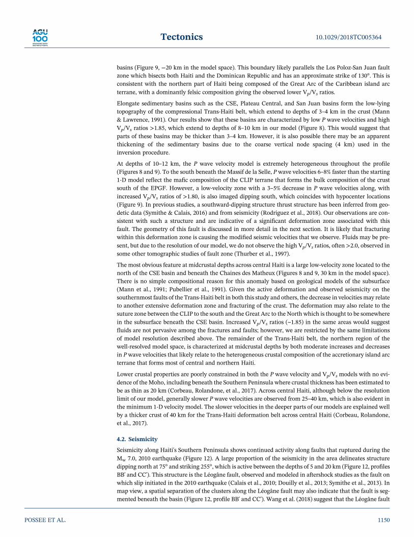
basins (Figure 9, −20 km in the model space). This boundary likely parallels the Los Poloz‐San Juan faultzone which bisects both Haiti and the Dominican Republic and has an approximate strike of 130°. This isconsistent with the northern part of Haiti being composed of the Great Arc of the Caribbean island arcterrane, with a dominantly felsic composition giving the observed lower Vp/Vs ratios.
Elongate sedimentary basins such as the CSE, Plateau Central, and San Juan basins form the low‐lyingtopography of the compressional Trans‐Haiti belt, which extend to depths of 3–4 km in the crust (Mann& Lawrence, 1991). Our results show that these basins are characterized by low P wave velocities and highVp/Vs ratios >1.85, which extend to depths of 8–10 km in our model (Figure 8). This would suggest thatparts of these basins may be thicker than 3–4 km. However, it is also possible there may be an apparentthickening of the sedimentary basins due to the coarse vertical node spacing (4 km) used in theinversion procedure.
At depths of 10–12 km, the P wave velocity model is extremely heterogeneous throughout the profile(Figures 8 and 9). To the south beneath the Massif de la Selle, P wave velocities 6–8% faster than the starting1‐D model reflect the mafic composition of the CLIP terrane that forms the bulk composition of the crustsouth of the EPGF. However, a low‐velocity zone with a 3–5% decrease in P wave velocities along, withincreased Vp/Vs ratios of >1.80, is also imaged dipping south, which coincides with hypocenter locations(Figure 9). In previous studies, a southward‐dipping structure thrust structure has been inferred from geo-detic data (Symithe & Calais, 2016) and from seismicity (Rodriguez et al., 2018). Our observations are con-sistent with such a structure and are indicative of a significant deformation zone associated with thisfault. The geometry of this fault is discussed in more detail in the next section. It is likely that fracturingwithin this deformation zone is causing the modified seismic velocities that we observe. Fluids may be pre-sent, but due to the resolution of our model, we do not observe the high Vp/Vs ratios, often >2.0, observed insome other tomographic studies of fault zone (Thurber et al., 1997).
The most obvious feature at midcrustal depths across central Haiti is a large low‐velocity zone located to thenorth of the CSE basin and beneath the Chaines des Matheux (Figures 8 and 9, 30 km in the model space).There is no simple compositional reason for this anomaly based on geological models of the subsurface(Mann et al., 1991; Pubellier et al., 1991). Given the active deformation and observed seismicity on thesouthernmost faults of the Trans‐Haiti belt in both this study and others, the decrease in velocities may relateto another extensive deformation zone and fracturing of the crust. The deformation may also relate to thesuture zone between the CLIP to the south and the Great Arc to the North which is thought to be somewherein the subsurface beneath the CSE basin. Increased Vp/Vs ratios (~1.85) in the same areas would suggestfluids are not pervasive among the fractures and faults; however, we are restricted by the same limitationsof model resolution described above. The remainder of the Trans‐Haiti belt, the northern region of thewell‐resolved model space, is characterized at midcrustal depths by both moderate increases and decreasesin Pwave velocities that likely relate to the heterogeneous crustal composition of the accretionary island arcterrane that forms most of central and northern Haiti.
Lower crustal properties are poorly constrained in both the P wave velocity and Vp/Vs models with no evi-dence of theMoho, including beneath the Southern Peninsula where crustal thickness has been estimated tobe as thin as 20 km (Corbeau, Rolandone, et al., 2017). Across central Haiti, although below the resolutionlimit of our model, generally slower P wave velocities are observed from 25–40 km, which is also evident inthe minimum 1‐D velocity model. The slower velocities in the deeper parts of our models are explained wellby a thicker crust of 40 km for the Trans‐Haiti deformation belt across central Haiti (Corbeau, Rolandone,et al., 2017).
4.2. Seismicity
Seismicity along Haiti's Southern Peninsula shows continued activity along faults that ruptured during theMw 7.0, 2010 earthquake (Figure 12). A large proportion of the seismicity in the area delineates structuredipping north at 75° and striking 255°, which is active between the depths of 5 and 20 km (Figure 12, profilesBB' and CC'). This structure is the Léogâne fault, observed and modeled in aftershock studies as the fault onwhich slip initiated in the 2010 earthquake (Calais et al., 2010; Douilly et al., 2013; Symithe et al., 2013). Inmap view, a spatial separation of the clusters along the Léogâne fault may also indicate that the fault is seg-mented beneath the basin (Figure 12, profile BB' and CC'). Wang et al. (2018) suggest that the Léogâne fault
10.1029/2018TC005364Tectonics
POSSEE ET AL. 1150

forms a conjugate pair with southward‐dipping faults such as the Lamentin thrust, accommodating shorten-ing across the region. Possible stress transfer between the faults during the 2010 earthquake (Saint Fleuret al., 2015) and the continued seismicity we observe on both faults is consistent with these fault systemsbeing coupled.
Seismicity located just south of the EPGF surface trace is shown to cluster at a depth of approximately 15 km(Figure 12, profile AA'). One interpretation of this seismicity is that it represents activity at depth on themain strike‐slip portion of the EPGF or small fractures in the surrounding damage zone associated withfaulting. However, a second interpretation is that these earthquakes occurred at the intersection of a blindthrust fault with the EPGF. In a recent study Wessels et al. (2019) mapped a new south‐dipping thrust fault,which they called the Redoute Fault (Figure 12). We propose that the seismicity we observe is occurring atthe subsurface intersection of this fault with the EPGF, which is consistent with proposed fault geometries(Wessels et al., 2019). The orientation of this structure is likely similar to the Petit Goâve‐Jacmel fault imagedto the west (Douilly et al., 2016) and a southward‐dipping oblique slip fault beneath the Massif de la Selle tothe east (Symithe & Calais, 2016). Seismicity rates on the Léogâne fault are also seen to increase at depths of7–10 km, the depth at which the fault intersects the EPGF (Figure 12, profile BB' and CC'). Therefore, anintersection of faults on the southern side of the EPGF may also explain the observed seismicity over thenarrow depth range of 15–20 km. This would also suggest that the EPGF is acting as a mechanical barrierto the propagation of active faults, observed through slip and the lack of surface rupture during the2010 earthquake.
To the east, there are twomain hypotheses for regional fault geometry. The first suggests the eastward exten-sion of a near vertical strand of the EPGF fault across the CSE basin, bisecting both Lake Azuei and LakeEnriquillo, based on evidence of curvilinear surface folds and shallow seismic structures (Mann et al.,1995; Wang et al., 2018). The second proposes that motion is primarily accommodated on NW‐SE strikingthrust faults on both the north and south margin of the CSE basin (Rodriguez et al., 2018; Saint Fleuret al., 2015; Symithe & Calais, 2016).
Our observations of seismicity beneath theMassif de la Selle show that hypocenters weakly delineate a broadsouthward‐dipping fault structure that dips at ~40° ± 10 (Figure 13, profile AA'). When projected to thesurface, the fault would intersect the surface along the southern border of the CSE basin. A south‐dippingfault at this location is consistent with linear fault propagation folds and reverse faults that have beenmapped along the southern edge of the basin (Mann et al., 1991; Saint Fleur et al., 2015). Symithe andCalais (2016) also showed that a 45° southward‐dipping oblique‐slip fault beneath southern Haiti was con-sistent with GPS observations of oblique slip, as oppose to a near vertical strike‐slip fault across the CSEbasin. Moment tensors for seismicity recorded south of the CSE basin also have a dominantly thrust compo-nent with an average NNE‐SSW P axis orientation (Rodriguez et al., 2018), which is consistent with thestrain directions calculated from GPS data (Calais et al., 2016).
Seismicity observed north of Lake Enriquillo, in the Dominican Republic (Figure 13), is relatively poorlyconstrained due to the location of these events in relation to the seismic network. Therefore, the seismicitywe observe is diffuse, especially with depth, and does not image any single structure. The epicenters are wellclustered along the northern edge of the CSE basin though. Pubellier et al. (2000) mapped these faults to beleft‐lateral reverse faults dipping north, controlling the formation of both the lake and the basin, suggestingthey represent the southernmost extent of the Trans‐Haiti deformation belt. However, sonar surveys lookingat the northern edge of the basin in Lake Azuei indicated there was little evidence for present day deforma-tion (Wang et al., 2018). Further west, moving along strike into the Gulf of Gonâve (300°), offshore seismicdata do show active compressional tectonics with north dipping reverse faults and folding perturbing themost recent sediments (Corbeau, Rolandone, Leroy,Meyer, et al., 2016). Moment tensors determined for thiscluster also have a significant thrust component, again with P axis that indicates a NNE‐SSW compressionorientation (Corbeau, Clouard, et al., 2017). We therefore suggest that the active seismicity we observe islinked to a north‐dipping reverse fault structure, similar to those observed in the field and part of theTrans‐Haiti deformation belt (Pubellier et al., 2000).
Our observations of active seismicity are therefore muchmore consistent with the hypothesis that east of theCSE basin (−72.3°W 18.6°N) NW‐SE‐orientated thrust faults are dominant on either margin of the basin, asopposed to a vertical strike‐slip structure cross cutting it. To the south, a seismically active southward‐
10.1029/2018TC005364Tectonics
POSSEE ET AL. 1151

dipping oblique fault accommodates much of the present‐daymotion in the region. On the northern margin,seismic activity on north‐dipping thrust faults indicates the southern‐most part of the Tran‐Haiti deforma-tion belt is likely still active.
4.3. Plate Boundary Faulting
The broad Caribbean‐North American plate boundary is spread across several fault zones, and nearHispaniola motion is primarily accommodated by the EPGF in the south and the SOFZ in the north.However, the lateral extent and simplicity of these twomajor fault zones is being challenged by our new dataset as well as recent geological and geodetic results (Saint Fleur et al., 2015; Symithe & Calais, 2016). Weobserve very little seismicity associated with a near vertical strike‐slip fault, such as the EPGF. Instead, seis-micity is associated with thrust structures such as the Léogâne fault, Trois Baies fault system, Petit Goâve‐Jacmel fault, and other NE‐SW striking faults dipping to the south, which are also imaged by low‐velocityzones. These observations suggest that the EPGF transitions from a primarily strike‐slip fault in westernHaiti, with a minor compressional element, to oblique thrust faulting along the southern edge of the CSEbasin and into the Dominican Republic. This represents a distinct change in the faulting geometry alongHaiti's Southern Peninsula and an important constraint for our understanding of seismic hazard along thisplate boundary fault.
In addition to the seismicity we detect in southern and central Hispaniola, we also record a large number ofevents in the north of the Dominican Republic and offshore (Figure 11). While these events are far outsideour network and have large location uncertainties, it seems clear that the two most seismically active faultsin this region are the SOFZ and the North Hispaniola fault, which lies offshore to the north. Rodriguez et al.(2018) also observed similarly high levels of seismicity associated with these faults; however, while the NorthHispaniola fault has been mapped offshore (Rodríguez‐Zurrunero et al., 2019), there is still much workneeded to fully characterize the structure of the SOFZ which bisects much of the northern DominicanRepublic onshore. The present day seismicity highlights the seismic hazard potential of the northern edgeof the Caribbean‐North American plate boundary, which can also be seen by the >Mw7.0 historical earth-quakes associated these faults (Prentice et al., 2010; ten Brink et al., 2011).
5. Conclusions
Seismicity recorded from the Trans‐Haiti network showed significant continued activity along faults asso-ciated with the Mw 7.0, 2010 earthquake on Haiti's Southern Peninsula throughout the observed time period(2013–2014). Hypocenters also revealed several south‐dipping faults beneath southern Haiti, most likelywith a significant thrust component, consistent with observed and modeled surface deformation. A clusterof seismic activity along the northern edge of the CSE basin also suggests the southernmost faults of theTrans‐Haiti belt may still be active. The hypocenters indicate seismic activity along the SOFZ in the northof Haiti; however, poor station coverage to the north within the Trans‐Haiti network meant a high magni-tude detection threshold for this region of our study. Future deployments are needed to fully quantify seis-mic activity along the SOFZ.
Models of Vp and Vp/Vs have provided an image of Haiti's regional crustal structure across a NNE profilethat bisects major tectonic domains and known‐fault structures. The results show that Haiti is composedof multiple compositionally distinct tectonic domains, welded together during the eastward movement ofthe Caribbean plate. Low Vp/Vs ratios in the northern Haiti are consistent with a crust composed of islandarc and fore‐arc accretionary prism facies from the Greater Antilles arc. Central and southern Haiti arecharacterized by high Vp/Vs ratios, which are pervasive in the upper 20 km of the crust that we image.This fits well with the view that southern Haiti is composed of mafic facies from the CLIP terrane.However, it also suggests that the island arc crust of central Haiti has been significantly modified throughcompressional tectonics and possibly Quaternary mafic volcanism causing the elevated Vp/Vs ratiosthroughout the crust.
We also find evidence in low‐velocity zones and seismicity that the EPGF transitions from a near verticalstrike‐slip fault to a southward dipping oblique‐slip thrust fault moving eastward along Haiti's SouthernPeninsula. This fault echoes other known thrust faults such as the Petit Goâve‐Jacmel fault further to the
10.1029/2018TC005364Tectonics
POSSEE ET AL. 1152

west. The transition is likely gradual along the Southern Peninsula but the EPGF certainly extends nofurther as a vertical strike‐slip fault beyond its intersection with CSE basin.
ReferencesAki, K. (1965). Maximum likelihood estimate of b in the formula logN= a‐bM and its confidence limits. Bulletin of the Earthquake Research
Institute, 43, 237–239.Bakun, W. H., Flores, C. H., & ten Brink, U. S. (2012). Significant earthquakes on the Enriquillo fault system, Hispaniola, 1500–2010:
Implications for seismic hazard. Bulletin of the Seismological Society of America, 102(1), 18–30. https://doi.org/10.1785/0120110077Bourgueil, B., Andreieff, P., Lasnier, J., Gonnard, R., Le Metour, J. & Rancon, J.‐P. (1988). Synthèse géologique de la République d'Haïti.
Technical Rep., Bureau des Mines et de L'Energie. Haiti, Port‐au‐Prince.Burke, K. (1988). Tectonic evolution of the Caribbean. Annual Review of Earth and Planetary Sciences, 16(1), 201–230. https://doi.org/
10.1146/annurev.ea.16.050188.001221Byrne, D., Suarez, G., & Mccann, W. (1985). Muertos Trough subduction—Microplate tectonics in the northern Caribbean? Nature,
317(6036), 420–421. https://doi.org/10.1038/317420a0Calais, E., & Mercier de Lépinay, B. (1995). Strike‐slip tectonic processes in the northern Caribbean between Cuba and Hispaniola
(windward passage). Marine Geophysical Researches, 17(1), 63–95. https://doi.org/10.1007/BF01268051Calais, E., Freed, A., Mattioli, G., Amelung, F., Jónsson, S., Jansma, P., et al. (2010). Transpressional rupture of an unmapped fault during
the 2010 Haiti earthquake. Nature Geoscience, 3(11), 794–799. https://doi.org/10.1038/ngeo992Calais, É., Symithe, S., Mercier de Lépinay, B., & Prépetit, C. (2016). Plate boundary segmentation in the northeastern Caribbean from
geodetic measurements and Neogene geological observations. Comptes Rendus Geoscience, 348(1), 42–51. https://doi.org/10.1016/j.crte.2015.10.007
Calmus, T. (1983). Contribution à l'étude géologique dumassif de Macaya (sud‐ouest d'Haïti, Grandes Antilles): sa place dans l'évolution del'orogène Nord‐Caraïbe.
Christensen, N. I. (1996). Poisson's ratio and crustal seismology. Journal of Geophysical Research, 101(B2), 3139–3156. https://doi.org/10.1029/95JB03446
Corbeau, J., Clouard, V., Rolandone, F., Leroy, S. D., & Mercier de Lépinay, B. (2017). Is the local seismicity in Haiti capable of imaging theNorthern Caribbean Subduction? AGU Fall Meeting Abstracts, 2017.
Corbeau, J., Rolandone, F., Leroy, S., Mercier de Lépinay, B., Meyer, B., Ellouz‐Zimmermann, N., & Momplaisir, R. (2016). The northernCaribbean plate boundary in the Jamaica Passage: Structure and seismic stratigraphy. Tectonophysics, 675, 209–226. https://doi.org/10.1016/j.tecto.2016.03.022
Corbeau, J., Rolandone, F., Leroy, S., Guerrier, K., Keir, D., Stuart, G., et al. (2017). Crustal structure of western Hispaniola (Haiti) from ateleseismic receiver function study. Tectonophysics, 709, 9–19. https://doi.org/10.1016/j.tecto.2017.04.029
Corbeau, J., Rolandone, F., Leroy, S., Meyer, B., Mercier de Lépinay, B., Ellouz‐Zimmermann, N., & Momplaisir, R. (2016). How trans-pressive is the northern Caribbean plate boundary? Tectonics, 35, 1032–1046. https://doi.org/10.1002/2015TC003996
Cowgill, E., Bernardin, T. S., Oskin, M. E., Bowles, C., Yıkılmaz, M. B., Kreylos, O., et al. (2012). Interactive terrain visualization enablesvirtual field work during rapid scientific response to the 2010 Haiti earthquake. Geosphere, 8(4), 787–804. https://doi.org/10.1130/GES00687.1
Cruz‐Orosa, I., Sàbat, F., Ramos, E., Rivero, L., & Vázquez‐Taset, Y. M. (2012). Structural evolution of the La Trocha fault zone: Obliquecollision and strike‐slip basins in the Cuban Orogen. Tectonics, 31, TC5001. https://doi.org/10.1029/2011TC003045
Douilly, R., Aochi, H., Calais, E., & Freed, A. (2015). Three‐dimensional dynamic rupture simulations across interacting faults: TheMw7.0,2010, Haiti earthquake. Journal of Geophysical Research: Solid Earth, 120, 1108–1128. https://doi.org/10.1002/2014JB011595
Douilly, R., Ellsworth, W. L., Kissling, E., Freed, A. M., Deschamps, A., & Mercier de Lépinay, B. (2016). 3‐D velocity structure in southernHaiti from local earthquake tomography. Journal of Geophysical Research: Solid Earth, 121, 8813–8832. https://doi.org/10.1002/2016JB013123
Douilly, R., Haase, J. S., Ellsworth, W. L., Bouin, M. P., Calais, E., Symithe, S. J., et al. (2013). Crustal structure and fault geometry of the2010 Haiti earthquake from temporary seismometer deployments. Bulletin of the Seismological Society of America, 103(4), 2305–2325.https://doi.org/10.1785/0120120303
Duncan, R., & Hargraves, R. (1984). Plate tectonic evolution of the Caribbean region in the mantle reference frame. Geological Society ofAmerica Memoirs, 162, 81–94. https://doi.org/10.1130/MEM162‐p81
Eberhart‐Phillips, D. (1990). Three‐dimensional P and S velocity structure in the Coalinga region, California. Journal of GeophysicalResearch, 95(B10), 15,343–15,363. https://doi.org/10.1029/JB095iB10p15343
Geldmacher, J., Hanan, B., Blichert‐Toft, J., Harpp, K., Hoernle, K., Hauff, F., et al. (2003). Hafnium isotopic variations in volcanic rocksfrom the Caribbean Large Igneous Province and Galápagos hot spot tracks. Geochemistry, Geophysics, Geosystems, 4(7), 1062. https://doi.org/10.1029/2002GC000477
Granja‐Bruña, J., Carbó‐Gorosabel, A., Estrada, P. L., Muñoz‐Martín, A., ten Brink, U., Ballesteros, M. G., et al. (2014). Morphostructure atthe junction between the Beata ridge and the Greater Antilles island arc (offshore Hispaniola southern slope). Tectonophysics, 618,138–163. https://doi.org/10.1016/j.tecto.2014.02.001
Hashimoto, M., Fukushima, Y., & Fukahata, Y. (2011). Fan‐delta uplift andmountain subsidence during the Haiti 2010 earthquake.NatureGeoscience, 4(4), 255–259. https://doi.org/10.1038/ngeo1115
Hastie, A. R., Mitchell, S. F., Treloar, P. J., Kerr, A. C., Neill, I., & Barfod, D. N. (2013). Geochemical components in a Cretaceous island arc:The Th/La–(Ce/Ce*) Nd diagram and implications for subduction initiation in the inter‐American region. Lithos, 162‐163, 57–69.https://doi.org/10.1016/j.lithos.2012.12.001
Hayes, G., Briggs, R., Sladen, A., Fielding, E., Prentice, C., Hudnut, K., et al. (2010). Complex rupture during the 12 January 2010 Haitiearthquake. Nature Geoscience, 3(11), 800–805. https://doi.org/10.1038/ngeo977
Heubeck, C., Mann, P., Dolan, J., & Monechi, S. (1991). Diachronous uplift and recycling of sedimentary basins during Cenozoic tectonictranspression, northeastern Caribbean plate margin. Sedimentary Geology, 70(1), 1–32. https://doi.org/10.1016/0037‐0738(91)90063‐J
Hutton, L., & Boore, D. M. (1987). The ML scale in southern California. Bulletin of the Seismological Society of America, 77, 2074–2094.Illsley‐Kemp, F., Keir, D., Bull, J. M., Ayele, A., Hammond, J. O., Kendall, J. M., et al. (2017). Local earthquake magnitude scale and b‐value
for the Danakil region of northern Afar. Bulletin of the Seismological Society of America, 107(2), 521–531. https://doi.org/10.1785/0120150253
10.1029/2018TC005364Tectonics
POSSEE ET AL. 1153
AcknowledgmentsThe work contained in this papercontains work conducted during a PhDstudy undertaken as part of the NaturalEnvironment Research Council(NERC) Centre for Doctoral Training(CDT) in Oil & Gas (grantNE/M00578X/1). It is 50% funded bySouthampton University via theirGraduate School of the NationalOceanography Centre Southampton(GSNOCS) and 50% funded by NERCboth of whose support is gratefullyacknowledged. We thank SeismicEquipment Infrastructure in the UK(SEIS‐UK) for the use of theinstruments and their computingfacilities. The facilities of SEIS‐UK aresupported by NERC under agreementR8/H10/64. C.A.R. and N.H.acknowledge funding from NERC (NE/M003507/1 and NE/K010654/1) andthe European Research Council (GA638665). S.L., F.R., and J.C.acknowledge full support from theInsitut des Sciences de la Tere Paris(ISTeP) to the Trans‐Haiti project. E.C.acknowledges support from theInterreg Caraibes/FEDER program tothe “PREST” project and from the“Institut Universitaire de France”. F. I.K. is funded through NERC studentshipNE/L002531/1, a grant to GSNOCSfrom Roy Franklin OBE and theECLIPSE Programme, funded by theNew Zealand Ministry of Business,Innovation and Employment. Wethank the Unité Technique deSismologie of the Bureau des Mines etde l'Energie and the URGeo of theUniversité d'Etat d'Haiti for their helpin the field. We thank Kelly Guerrier,Sophia Ulysse, and Frantz Saint Preuxfor their active contribution in instal-ling the seismic stations and collectingthe data. We also thank Tom Hall forhis involvement in the fieldwork anddata processing. The catalog of earth-quakes located and used in this studycan be found in the supporting infor-mation. Data for the Trans‐HaitiNetwork, Canadian NationalSeismograph Network, and U.S.Geological Survey stations can bedownloaded from the IncorporatedResearch Institutions for Seismology(IRIS).

Kamenov, G. D., Perfit, M. R., Lewis, J. F., Goss, A. R., Arévalo, R. Jr., & Shuster, R. D. (2011). Ancient lithospheric source for Quaternarylavas in Hispaniola. Nature Geoscience, 4(8), 554–557. https://doi.org/10.1038/ngeo1203
Kennett, B., Engdahl, E., & Buland, R. (1995). Constraints on seismic velocities in the Earth from traveltimes. Geophysical JournalInternational, 122(1), 108–124. https://doi.org/10.1111/j.1365‐246X.1995.tb03540.x
Kissling, E., Ellsworth, W., Eberhart‐Phillips, D., & Kradolfer, U. (1994). Initial reference models in local earthquake tomography. Journalof Geophysical Research, 99(B10), 19,635–19,646. https://doi.org/10.1029/93JB03138
Kocel, E., Stewart, R. R., Mann, P., & Chang, L. (2016). Near‐surface geophysical investigation of the 2010 Haiti earthquake epicentral area:Léogâne, Haiti. Interpretation, 4(1), T49–T61. https://doi.org/10.1190/INT‐2015‐0038.1
Ladd, J. W., Worzel, J. L., & Watkins, J. S. (1977). Multifold seismic reflection records from the northern Venezuela Basin and the northslope of the Muertos Trench. In Island arcs, deep sea trenches and back‐arc basins (pp. 41–56). Washington, DC: American GeophysicalUnion. https://doi.org/10.1029/ME001p0041
Leroy, S., Ellouz‐Zimmermann, N., Corbeau, J., Rolandone, F., Mercier de Lépinay, B., Meyer, B., et al. (2015). Segmentation and kine-matics of the North America‐Caribbean plate boundary offshore Hispaniola. Terra Nova, 27(6), 467–478. https://doi.org/10.1111/ter.12181
Leroy, S., Mauffret, A., Patriat, P., & Mercier de Lépinay, B. (2000). An alternative interpretation of the Cayman trough evolution from areidentification of magnetic anomalies. Geophysical Journal International, 141(3), 539–557. https://doi.org/10.1046/j.1365‐246x.2000.00059.x
Lomax, A., Virieux, J., Volant, P., & Berge‐Thierry, C. (2000). Probabilistic earthquake location in 3D and layered models. In Advances inSeismic Event Location (pp. 101–134). Dordrecht, Netherlands: Springer. https://doi.org/10.1007/978‐94‐015‐9536‐0_5
Manaker, D. M., Calais, E., Freed, A. M., Ali, S., Przybylski, P., Mattioli, G., et al. (2008). Interseismic plate coupling and strain parti-tioning in the northeastern Caribbean. Geophysical Journal International, 174(3), 889–903. https://doi.org/10.1111/j.1365‐246X.2008.03819.x
Mann, P., Draper, G., & Lewis, J. F. (1991). An overview of the geologic and tectonic development of Hispaniola. Geological Society ofAmerica Special Papers, 262, 1–28. https://doi.org/10.1130/SPE262‐p1
Mann, P., & Lawrence, S. (1991). Petroleum potential of southern Hispaniola. Journal of Petroleum Geology, 14(2), 291–308. https://doi.org/10.1111/j.1747‐5457.1991.tb00313.x
Mann, P., Taylor, F., Edwards, R. L., & Ku, T.‐L. (1995). Actively evolving microplate formation by oblique collision and sideways motionalong strike‐slip faults: An example from the northeastern Caribbean plate margin. Tectonophysics, 246(1‐3), 1–69. https://doi.org/10.1016/0040‐1951(94)00268‐E
Mauffret, A., & Leroy, S. (1997). Seismic stratigraphy and structure of the Caribbean igneous province. Tectonophysics, 283(1‐4), 61–104.https://doi.org/10.1016/S0040‐1951(97)00103‐0
Mauffret, A., Leroy, S., d'Acremont, É., Maillard, A., Mercier de Lépinay, B., Dos Reis, A. T., et al. (2001). Une coupe de la province vol-canique Caraı ̈be: premiers résultats de la campagne sismique Casis 2. Comptes Rendus de l'Académie des Sciences ‐ Series IIA ‐ Earth andPlanetary Science, 333, 659–667.
Mercier de Lépinay, B., Deschamps, A., Klingelhoefer, F., Mazabraud, Y., Delouis, B., Clouard, V., et al. (2011). The 2010 Haiti earthquake:A complex fault pattern constrained by seismologic and tectonic observations. Geophysical Research Letters, 38, L22305. https://doi.org/10.1029/2011GL049799
Momplaisir, R. (1986). Contribution a l'Etude Geologique de la partie orientale du massif de la hotte (presqu'ile de sud d'Haiti): Synthesestructurale des marges de la presqu'ile a partir de donnees sismiques. (PhD thesis). University Pierre‐et‐Marie‐Curie (Paris VI).
Moreno, B., Grandison, M., & Atakan, K. (2002). Crustal velocity model along the southern Cuban margin: Implications for thetectonic regime at an active plate boundary. Geophysical Journal International, 151(2), 632–645. https://doi.org/10.1046/j.1365‐246X.2002.01810.x
Nettles, M., & Hjörleifsdóttir, V. (2010). Earthquake source parameters for the 2010 January Haiti main shock and aftershock sequence.Geophysical Journal International, 183(1), 375–380. https://doi.org/10.1111/j.1365‐246X.2010.04732.x
Pindell, J., Maresch, W. V., Martens, U., & Stanek, K. (2012). The Greater Antillean Arc: Early Cretaceous origin and proposed relationshipto Central American subductionmélanges: Implications formodels of Caribbean evolution. International Geology Review, 54(2), 131–143.https://doi.org/10.1080/00206814.2010.510008
Pindell, J. L. (1990). Geological evolution of the Caribbean region: A plate‐tectonic perspective (pp. 339–374). The Caribbean Region: Boulder,CO: Geological Society of America, the Geology of North America H.
Prentice, C., Mann, P., Crone, A., Gold, R., Hudnut, K., Briggs, R., et al. (2010). Seismic hazard of the Enriquillo‐Plantain Garden fault inHaiti inferred from palaeoseismology. Nature Geoscience, 3(11), 789–793. https://doi.org/10.1038/ngeo991
Pubellier, M., Mauffret, A., Leroy, S., Vila, J. M., & Amilcar, H. (2000). Plate boundary readjustment in oblique convergence: Example of theNeogene of Hispaniola, Greater Antilles. Tectonics, 19(4), 630–648. https://doi.org/10.1029/2000TC900007
Pubellier, M., Vila, J.‐M., & Boisson, D. (1991). North Caribbean neotectonic events: The Trans‐Haitian fault system. Tertiary record of anoblique transcurrent shear zone uplifted in Hispaniola. Tectonophysics, 194(3), 217–236. https://doi.org/10.1016/0040‐1951(91)90262‐Q
Richter, C. F. (1935). An instrumental earthquake magnitude scale. Bulletin of the Seismological Society of America, 25, 1–32.Rios, J., Mchugh, C., Hornbach, M., Mann, P., Wright, V., & Gurung, D. (2013). Holocene activity of the Enriquillo‐Plantain Garden Fault
in Lake Enriquillo derived from seismic stratigraphy. AGU Fall Meeting Abstracts, 2013.Rodriguez, J., Havskov, J., Sørensen, M. B., & Santos, L. F. (2018). Seismotectonics of south‐west Dominican Republic using recent data.
Journal of Seismology, 22(4), 883–896. https://doi.org/10.1007/s10950‐018‐9738‐9Rodríguez‐Zurrunero, A., Granja‐Bruña, J., Carbó‐Gorosabel, A., Muñoz‐Martín, A., Gorosabel‐Araus, J. M., De La Peña, L. G., et al.
(2019). Submarine morpho‐structure and active processes along the North American‐Caribbean plate boundary (Dominican Republicsector). Marine Geology, 407, 121–147. https://doi.org/10.1016/j.margeo.2018.10.010
Saint Fleur, N., Feuillet, N., Grandin, R., Jacques, E., Weil‐Accardo, J., & Klinger, Y. (2015). Seismotectonics of southern Haiti: A newfaulting model for the 12 January 2010 M7.0 earthquake. Geophysical Research Letters, 42, 10,273–10,281. https://doi.org/10.1002/2015GL065505
Scordilis, E. (2006). Empirical global relations converting M S and m b to moment magnitude. Journal of Seismology, 10(2), 225–236.https://doi.org/10.1007/s10950‐006‐9012‐4
Shearer, P. M. (1988). Cracked media, Poisson's ratio and the structure of the upper oceanic crust. Geophysical Journal International, 92(2),357–362. https://doi.org/10.1111/j.1365‐246X.1988.tb01149.x
Symithe, S., & Calais, E. (2016). Present‐day shortening in Southern Haiti from GPS measurements and implications for seismic hazard.Tectonophysics, 679, 117–124. https://doi.org/10.1016/j.tecto.2016.04.034
10.1029/2018TC005364Tectonics
POSSEE ET AL. 1154

Symithe, S. J., Calais, E., Haase, J. S., Freed, A. M., & Douilly, R. (2013). Coseismic slip distribution of the 2010 M 7.0 Haiti earthquake andresulting stress changes on regional faults. Bulletin of the Seismological Society of America, 103(4), 2326–2343. https://doi.org/10.1785/0120120306
ten Brink, U. S., Bakun, W. H., & Flores, C. H. (2011). Historical perspective on seismic hazard to Hispaniola and the northeast Caribbeanregion. Journal of Geophysical Research, 116, B12318. https://doi.org/10.1029/2011JB008497
Terrier, M., Bialkowski, A., Nachbaur, A., Prépetit, C., & Joseph, Y. (2014). Revision of the geological context of the Port‐au‐Princemetropolitan area, Haiti: Implications for slope failures and seismic hazard assessment. Natural Hazards and Earth System Sciences,14(9), 2577–2587. https://doi.org/10.5194/nhess‐14‐2577‐2014
Thurber, C., & Eberhart‐Phillips, D. (1999). Local earthquake tomography with flexible gridding. Computers & Geosciences, 25(7), 809–818.https://doi.org/10.1016/S0098‐3004(99)00007‐2
Thurber, C., Roecker, S., Ellsworth, W., Chen, Y., Lutter, W., & Sessions, R. (1997). Two‐dimensional seismic image of the San AndreasFault in the Northern Gabilan range, Central California: Evidence for fluids in the fault zone. Geophysical Research Letters, 24(13),1591–1594. https://doi.org/10.1029/97GL01435
Thurber, C. H. (1983). Earthquake locations and three‐dimensional crustal structure in the Coyote Lake area, central California. Journal ofGeophysical Research, 88(B10), 8226–8236. https://doi.org/10.1029/JB088iB10p08226
Um, J., & Thurber, C. (1987). A fast algorithm for two‐point seismic ray tracing. Bulletin of the Seismological Society of America, 77, 972–986.https://doi.org/10.1007/s11589‐005‐0062‐4
Wang, J., Mann, P., & Stewart, R. R. (2018). Late Holocene structural style and seismicity of highly transpressional faults in southern Haiti.Tectonics, 37(10), 3834–3852. https://doi.org/10.1029/2017TC004920
Wessels, R. J., Ellouz‐Zimmermann, N., Bellahsen, N., Hamon, Y., Rosenberg, C., Deschamps, R., et al. (2019). Polyphase tectonic history ofthe Southern Peninsula, Haiti: From folding‐and‐thrusting to transpressive strike‐slip. Tectonophysics, 751, 125–149. https://doi.org/10.1016/j.tecto.2018.12.011
Wiemer, S., & Wyss, M. (2000). Minimum magnitude of completeness in earthquake catalogs: Examples from Alaska, the western UnitedStates, and Japan. Bulletin of the Seismological Society of America, 90(4), 859–869. https://doi.org/10.1785/0119990114
Wiggins‐Grandison, M. D. (2004). Simultaneous inversion for local earthquake hypocentres, station corrections and 1‐D velocity model ofthe Jamaican crust. Earth and Planetary Science Letters, 224(1‐2), 229–240. https://doi.org/10.1016/j.epsl.2004.05.009
Woessner, J., & Wiemer, S. (2005). Assessing the quality of earthquake catalogues: Estimating the magnitude of completeness and itsuncertainty. Bulletin of the Seismological Society of America, 95(2), 684–698. https://doi.org/10.1785/0120040007
Zhao, D., Kanamori, H., Negishi, H., &Wiens, D. (1996). Tomography of the source area of the 1995 Kobe earthquake: Evidence for fluids atthe hypocenter? Science, 274(5294), 1891–1894. https://doi.org/10.1126/science.274.5294.1891
10.1029/2018TC005364Tectonics
POSSEE ET AL. 1155