the threat of gps jamming-jcoffed - harris.com · gps jammers are being used by criminals to hide...
TRANSCRIPT

The Threat of GPS Jamming
The Risk to an Information Utility
Jeff [email protected]
Harris Corporation

Non-Export-Controlled Information 2 The Threat of GPS Jamming—The Risk to an Information Utility
THE RISK TO AN INFORMATION UTILITY ..............................3
Overview of GPS ...................................................................3
How GPS Works ....................................................................3
ECONOMIC IMPACT OF GPS ...................................................4
GPS Application Growth ......................................................5
THE RISK AND THREAT ...........................................................6
Jammers .................................................................................6
U.S. LAWS GOVERNING JAMMERS ........................................7
THE RISK IS REAL .....................................................................8
San Diego Harbor .................................................................8
Newark Airport .....................................................................8
Ships in the English Channel ................................................9
Power Companies .................................................................9
The Stock Market ..................................................................9
The Shipping Industry ........................................................10
TAKING ACTION .....................................................................11
SUMMARY .............................................................................12
ABOUT THE AUTHOR ............................................................12
ENDNOTES .............................................................................12
TABLE OF CONTENTS
2

Non-Export-Controlled Information 3 The Threat of GPS Jamming—The Risk to an Information Utility
The Risk of GPS Jamming THE RISK TO AN INFORMATION UTILITY
The Global Positioning System (GPS) has become a ubiquitous “utility” supporting critical infrastructure depended on by many across all industries. Originally developed for providing precision navigation and timing to the United States Military, society has rapidly developed a strong reliance on GPS information in many facets of life including transportation, communications, and financial transactions.
GPS has become an indispensable source of information with significant economic benefits, making it increasingly important that GPS data be available and reliable. In fact, GPS boosts productivity in many sectors including law enforcement, civil safety response, farming, mining, surveying, and package delivery. It is estimated more than 3.3 million jobs rely heavily on GPS in the United States, generating approximately $122.4 billion in annual economic benefits.1
This paper focuses on GPS and its susceptibility to service outages due to both intentional and unintentional jamming. Jamming is the act of interfering with a system’s capacity to lock onto the GPS signal, eliminating a user’s ability to receive the necessary information.
Future satellite designs are being prepared to improve the transmission capability and secu-rity of GPS data. However, addressing GPS information outages needs to occur now as the availability and usage of low-cost GPS jamming devices has resulted in a growing threat of GPS signal disruption and increasing the likelihood of future outages to systems that rely on GPS data. Addressing the security of GPS signals and preventing denial of services should be a priority.
The Global Positioning System (GPS) is a satellite based navigation system comprised of a network of orbiting satellites that provide location and time information, anywhere on or near the Earth.
GPS was originally intended to be used for military applications, but was made available for civilian use in the 1980’s. GPS is maintained by the United States Government and is freely accessible to anyone with a GPS receiver. Examples of receivers include car navigation systems, hand-held units for hiking, or smart-phones.
HOW GPS WORKS
GPS satellites circle the earth twice a day at an altitude of 13,000 miles in a precise orbit transmitting signal information (Figure 1). Each satellite continually broadcasts its location and the time as measured by precise on-board atomic clocks. A GPS receiver compares the time with its internal clock, calculates how far it is from each satellite, and then uses a method called “triangulation” to calculate a user’s location.
Triangulation is a way of determining a location using the fixed locations of two other points a known distance apart. This information is then displayed as the user’s position on an electronic map. The GPS receiver must be locked into at least three satellites to determine a user’s 2D position (latitude and longitude) and at least four satellites to determine their 3D position (latitude, longitude and altitude). Once the user’s location has been determined, information such as distance to a destination, speed, and more can be calculated.
Overview of GPS
Facts about GPS Satellites › First GPS satellite launched
in 1978 › Full constellation of 24
satellites was achieved in 1994 › Current constellation consists
of over 30 vehicles › Satellites are built to last
about 10 years › Replacements are being built
and launched into orbit › GPS satellites weigh
approximately 2,000 pounds and are about 17 feet across www.nasa.gov

The Threat of GPS Jamming—The Risk to an Information UtilityNon-Export-Controlled Information 4
Economic Impact of GPS
GPS satellites contain multiple atomic clocks that contribute very precise time data to the GPS signals. Receivers decode these signals, effectively synchronizing their time to the atomic clocks. This enables users to determine time to within 100 billionths of a second without the cost of owning and operating an atomic clock.
Precise time is crucial to a variety of economic activities around the world. Financial networks, communication systems, and electrical power grids all rely on precision timing for synchronization and operational efficiency. Major investment banks use GPS time to synchronize their network computers located around the world. Large and small businesses are turning to automated systems that can track, update, and manage multiple transactions made by a global network of customers.
The free availability of GPS time has enabled cost savings for companies that depend on precise time and has led to significant advances in capabilities.
Over the past twenty years, GPS technology has transformed lifestyles and businesses with many applications across all industries and walks of life. In addition to creating efficiencies and reducing operating costs, the adoption of GPS technology has improved safety, emergency response times, environmental quality, and has delivered many other benefits. The market for GPS has grown into a multi-billion dollar industry with growing potential.
There are different predictions to the size of economic impact, but these projections agree that it is substantial. For example, NDP Consulting Group estimates the direct economic benefits of GPS technology on commercial users will be over $67.6 billion per year in the United States.2 Paul Verhoef, Program Manager for the European Union (EU) Satellite Navigation, stated that “6 to 7 percent of the European Union gross domestic product (GDP) is directly dependent on the availability of GPS.”3
GPS technology creates jobs and other activities that spur economic growth. Studies have shown sustained productivity benefits and job creation in downstream industries and the U.S. economy as a whole.4 GPS technology has created both positive direct and indirect spillover:
› 3.3 million jobs that rely on GPS technology, including 130,000 jobs in GPS manufacturing industries and 3.2 million in the downstream commercial GPS-intensive industries5
› Improved public safety and national defense
› Time savings, workplace health and safety gains, job creation and reduction in emissions from fuel savings.
Figure 1 – The current constellation is comprised of over 30 GPS Satellites.
Photo courtesy of Lockheed Martin
GPS technology will create an estimated $122.4 billion in benefits per year and will affect more than 5.8 million in the downstream commercial GPS-intensive industries when penetration of GPS technology reaches 100 percent.GPS World, “The Economics of Disruption: $96 billion annually at Risk”, July 1, 2011

The Threat of GPS Jamming—The Risk to an Information UtilityNon-Export-Controlled Information 5
GPS APPLICATION GROWTH
Personal GPS tracking devices and applications are expected to grow at a rate of at least 40 percent per year.6 Additional GPS applications will help consumers track workouts and enjoy outdoor games and activities. The market for GPS fitness watches is anticipated to total $1.07 billion in 2013. These watches have features that include weight trackers, body fat percentage calculators, training scorers, heart-based calorie counters, and other sport-specific data features.7 The following table provides additional examples of applications across a variety of industries.
Industry Application
Agriculture Farm planning, field mapping, soil sampling, tractor guidance, crop scouting
Environment Aerial studies for conservation efforts, strategic planning
Marine Search and rescue, vessel position, underwater surveying, hazard location and mapping
Public Safety and Disaster Relief
Search and rescue, management of wildfires, earthquake anticipation, storm tracking, flood prediction
Rail Positive Train Control (PTC) to prevent collisions, derailments, and work zone incursions
Recreation Outdoor exploration, recreational skiing, aviation and boating
Roads & Highways Automatic vehicle location, in-vehicle navigation, ride-share matching
Surveying and Mapping Accurate mapping and modeling of the physical world, surveying coasts and waterways
Table 1: Applications Across Industries (Source: www.GPS.gov/applications)

The Threat of GPS Jamming—The Risk to an Information UtilityNon-Export-Controlled Information 6
The Risk and Threat Brandon Wales, Director of Homeland Infrastructure Threat and Risk Analysis Center for the Department of Homeland Security, warned in late 2011, “U.S. critical infrastructure sectors are increasingly at risk from a growing dependency on GPS for positioning, navigation, and timing services.” He stated that GPS reliance in many critical systems is either not fully understood or is often taken for granted and describes GPS as a “largely invisible utility.”9
Power distribution networks, banking and financial trading systems, broadcasting and industrial-control networks all use GPS timing, making them equally vulnerable to unintentional or deliberate interference.
In a March 2011 Royal Academy of Engineering (RAE) report, the author, Dr. Martyn Thomas, stated, “the financial markets, for instance, rely on a globally synchronized time-stamping mechanism to ensure fair trading. Trading systems might be detecting very small differences in prices between commodities on different exchanges and buying in high volume on one and selling on the other. Since lots of people are in competition trading on different continents, for these activities to work you need to know whose order is getting in first.”10
A report issued by NDP Consulting Group in June 2011 noted that the direct economic costs of full GPS disruption to commercial GPS users and GPS manufacturers are estimated to be $96 billion per year in the United States or the equivalent of 0.7 percent of the U.S. economy.11
JAMMERS
There are people who want to interfere with GPS signals because they are engaged in smuggling, theft, or simply trying to escape tracking of their daily movements. They are turning to devices that use radio frequency transmitters to intentionally block, jam, or inter-fere with lawful communications.
GPS signals come from satellites 13,000 miles away with signal strength of about 1.5 dB (home television signals usually range from 25 to 46 dB). A small jammer (Figure 2) can disrupt the GPS signal for a mile or more.12
The fact that GPS signal strength is weak is not a design flaw. These radio signals are complex and contain multiple components, including time, ephemeris data, and information about the health of the satellite. To constantly produce and broadcast these signals from solar powered satellites requires a design balancing act between allocating energy, equipment and other resources. This was acknowledged by Colonel Bernard Gruber – former Commander of the GPS Directorate, Space and Missile Systems Center, Air Force Space Command, Los Angeles Air Force Base – in an interview from the July 13, 2013 edition of Inside GNSS, “by design, GNSS signals are weak and vulnerable to intentional and unintentional interference.”13
An example of unintentional jamming was noted in the July 27, 2013, edition of The Economist – for nearly ten minutes each day, near the London Stock Exchange, someone was blocking GPS signals. Navigation systems in cars stopped working and time stamps on financial trades were affected. It was determined that the offender was a delivery driver hiding from his management.14
GPS jammers are being used by criminals to hide the fact they are driving stolen cars or by commercial drivers to conceal they are driving for dangerously long hours.
It has been reported that a 500 meter shield is created around a vehicle that uses a simple jamming device plugged into a cigarette lighter. Within that shielded area, other GPS devices are left inoperable. For example, navigation technology is unintentionally disrupted when an exhausted taxi cab driver wants to take a break and plugs in a GPS jammer to avoid detection.
“Society may already be dangerously over-reliant on satellite radio navigation systems like GPS... signal failure or interference could potentially affect safety systems and other critical parts of the economy.”
UK Royal Academy of Engineering Report: Global Navigation Space Systems: reliance and vulnerabilities
Jamming Jamming is the transmission of a noise signal across one or more of the GPS/GNSS frequencies to raise the noise level or overload the receiver circuitry and cause a loss of lock.
Commercial jammers, which might be used by car thieves, those keen to avoid road tolls, and commercial drivers not wanting to be tracked by their bosses have become increasingly sophisticated.
“Global Navigation Space Systems: reliance and vulnerabilities” by the Royal Academy of Engineering 2011
The Threat of GPS Jamming—The Risk to an Information UtilityNon-Export-Controlled Information 7
U.S Laws Governing Jammers
Federal law prohibits the operation, marketing, or sale of any type of jamming equipment. Indication that jammers are becoming increasingly problematic is indicated by a recent statement issued by the Enforcement Bureau of the Federal Communications Commission (FCC):
In recent years, the number of websites offering “cell jammers” or similar devices designed to block communications and create a “quiet zone” in vehicles, schools, theaters, restaurants, and other places, has increased substantially. While these devices are marketed under different names, such as signal blockers, GPS jammers, or text stoppers, they have the same purpose. We remind and warn consumers that it is a violation of federal law to use a cell jammer or similar devices that intentionally block, jam, or interfere with authorized radio communications such as cell phones, police radar, GPS, and Wi-Fi. Despite some marketers’ claims, consumers cannot legally use jammers within the United States, nor can retailers lawfully sell them.15
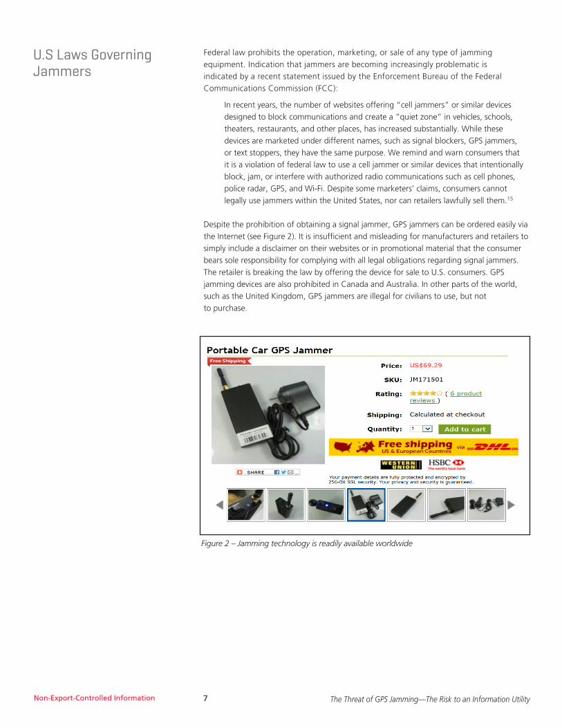
Despite the prohibition of obtaining a signal jammer, GPS jammers can be ordered easily via the Internet (see Figure 2). It is insufficient and misleading for manufacturers and retailers to simply include a disclaimer on their websites or in promotional material that the consumer bears sole responsibility for complying with all legal obligations regarding signal jammers. The retailer is breaking the law by offering the device for sale to U.S. consumers. GPS jamming devices are also prohibited in Canada and Australia. In other parts of the world, such as the United Kingdom, GPS jammers are illegal for civilians to use, but not to purchase.
Figure 2 – Jamming technology is readily available worldwide

The Threat of GPS Jamming—The Risk to an Information UtilityNon-Export-Controlled Information 8
The Risk Is Real Both the motive and the means to jam or render GPS capabilities useless are clearly evident in our society. Whether intentional or inadvertent, jamming GPS signals poses a significant risk to our daily lives, with potentially larger, long standing impacts. Examples that highlight the real risk of GPS jamming have been reported.
SAN DIEGO HARBOR
In January 2007, GPS services were significantly disrupted throughout San Diego, California (Figure 3). Impacts included Naval Medical Center emergency pagers stopped working, the harbor traffic-management system used for guiding boats failed, airport traffic control used backup systems and processes to maintain air traffic flow, cell phones users found they had no signal, and bank customers trying to withdraw cash from Automated Teller Machines (ATMs) were refused.
It took three days to find an explanation for this mysterious event: two Navy ships in the San Diego harbor had been conducting a training exercise when technicians jammed radio signals. Unwittingly, they also blocked GPS signals across a broad swath of the city.
NEWARK AIRPORT
In August 2013, the FCC fined a Readington, New Jersey, man nearly $32,000 after concluding he interfered with Newark Liberty International Airport’s satellite-based tracking system by using an illegal GPS jamming device in his pickup truck to hide from his employer. The signals emanating from the vehicle blocked the reception of GPS signals used by the air traffic control system.
In another incident in late 2009, engineers noticed that satellite-positioning receivers for a new navigation aid at the airport would lose signal during certain times of the day. The Federal Aviation Administration (FAA) investigated the problem and after two months discovered that a local truck driver had installed an inexpensive jammer in his vehicle. The driver was using the jammer to prevent his employer from tracking his movements. When he passed the airport area in his daily routine, the airport’s systems would temporarily fail.
Airports and the FAA have back-up plans, processes and redundant systems that keep passengers safe. The GPS interference threat is real, but airports are better equipped to handle GPS outages than other industries that also rely on accurate GPS time and/or location data.
General AviationPilot Report:
GPS Malfunction
AIS Display Console
Anomoly
DGPS SiteInoperative
2 Hours
Potential forFirst Responder
Impacts
Cell Provider Network 150 sites detected error
2 sites inoperative
Medical System PagingProvider Network
Inoperative1.5 hours- 20 sites

The Threat of GPS Jamming—The Risk to an Information UtilityNon-Export-Controlled Information 9
SHIPS IN THE ENGLISH CHANNEL
The U.K. has deployed a back-up ship navigation system in the English Channel to tackle the ever increasing risk of disruption to vessel GPS navigation devices. Seagoing vessels employ GPS to efficiently navigate and without it dense traffic patterns (figure 4) would require additional shipboard crew. The General Lighthouse Authorities (GLA) of the U.K. and Ireland launched a radio-based back-up system called eLoran to counter threats of jamming and GPS signal loss.
POWER COMPANIESPower companies and other utilities rely on accurate time and frequency information to enable efficient power transmission and distribution. Blackouts have demonstrated the need for improved time synchronization throughout the power grid and have led many power companies to place GPS-based time synchronization devices in power plants and substations.
THE STOCK MARKETIn February of 2012, a story in the U.K. Metro newspaper read “GPS jammers could make criminals millions in the stock market. Fraudsters could make millions in seconds by hacking into GPS systems synchronizing stock market deals around the world, experts are warning.”16 Every trade is time-stamped using GPS clocks that are monitored by computer systems down to the millisecond. Many programs are designed to pull out of the market if something seems amiss, opening the door to a liquidity crisis or even a potential mini-market crash.
Figure 4 – Chart depiction of marine traffic in the English Channel in May, 2011. (MarineTraffic.com)

The Threat of GPS Jamming—The Risk to an Information UtilityNon-Export-Controlled Information 10
THE SHIPPING INDUSTRY
In 1956, the use of the shipping container began as the brainchild of American trucking magnate Malcolm McLean. As simplistic in form as it is, containerization has transformed global trade.
Shipping businesses understand the importance of monitoring and protecting cargo. Whether a shipping container is marked for domestic or international delivery, the data providing the location of any shipment is critical.
GPS tracking systems are used by the shipping industry as a deterrent to potential theft of valuable cargo, as well as to ensure predictable delivery times. According to Cargo Security International, a website and journal for professionals involved in maritime and transport security, cargo theft cost shipping businesses over $25 billion dollars annually.17
When a single container of electronics, computer equipment or tobacco can result in a lucrative payoff for criminals, the temptation of theft will always be there.
In a possible jamming scenario, several truck drivers making cargo pick-ups near an active shipping port could employ “personal privacy” GPS jammers. Their deeds have the potential for causing interference with the GPS information critical to routine operations of large container ships as well as cargo tracking and management systems (Figure 5).
With criminals viewing theft of cargo goods as a low-risk, high-reward equation, shipping companies need to be aware of the threats to GPS tracking technology and put measures in place to thwart the intentional efforts of thieves and the unintentional effects of those trying to avoid being tracked.
Figure 5 – GPS interruption could compromise cargo and the operation of a port.

The Threat of GPS Jamming—The Risk to an Information UtilityNon-Export-Controlled Information 11
Taking Action Many individuals do not realize how much of our infrastructure is dependent upon GPS signals and information. Industries around the world utilize GPS for a variety of applications that effect everyday life.
GPS jamming is an increasing worldwide problem. The first and best step to take is to pursue technologies that can detect and locate GPS jammers.
Harris has developed technology, Signal Sentry™ 1000, that detects sources of intentional and unintentional interference to GPS signals and provides actionable intelligence. Harris leveraged their signal domain knowledge of the Global Navigation Satellite System (GNSS) to develop Signal Sentry 1000. This solution enables 3D geolocation of interference sources and provides visualization tools (figure 6) to support timely and effective actionable intelligence in GPS denied and contested environments.
Signal Sentry 1000 system sensors can be strategically located around high-risk areas, such as marine ports or utility grids, to instantaneously sense and triangulate the location of jamming sources. The Signal Sentry server is then able to identify the characteristics of each interference source separately and should a threat be detected, users would receive pin-point geolocation information in order to respond. To find out more, please visit the Harris Signal Sentry website at: www.exelisinc.com/signalsentry.
Figure 6 – Harris Signal SentryTM 1000 user interface
GNSS Domain ExpertiseHarris is the leading global provider of positioning, navigation, and timing (PNT) products, systems and solutions with over 40 years of demonstrated performance for military, civil government and commercial customers relying on reliable and secure GPS navigation and timing services. Harris GPS navigation systems have accumulated more than 750 years of on-orbit life with a demonstrated 100-percent hardware and software success rate. Harris has provided payloads to all U.S. GPS satellite missions.

The Threat of GPS Jamming—The Risk to an Information UtilityNon-Export-Controlled Information 12
GPS is a ubiquitous “utility” that supports critical infrastructure including: law enforcement, transportation, communications, and financial transactions, just to name a few. It has become a vital source of information with significant economic benefit. As previously noted, more than 3.3 million U.S. jobs are estimated to rely heavily on GPS. It is of paramount importance that GPS is reliable, available and secure.
GPS is susceptible to service outages due to intentional and unintentional jamming. To maintain critical infrastructure, proactive measures must be taken to eliminate GPS disruptions. Addressing the security of GPS signals and preventing denial of service should be a priority. Detection and tracking is the best and first step to take as the availability and usage of low-cost GPS jamming devices has resulted in an increased threat to GPS signal disruption.
Harris clearly understands the threat of signal disruption and the economic, safety, and security implications that disruptions can cause. Harris Signal Sentry™ 1000 was developed to enable authorities to locate with pin-point accuracy the sources of interference thereby assuring safety, efficiency, and revenue.
Jeff Coffed, Senior Manager, Strategic Marketing with Harris, is a marketing professional with over 20 years’ experience in the high-tech sector. Currently, he has strategic marketing responsibility for Harris’s Positioning Navigation and Timing (PNT) and Energy business areas.
1. PR Newswire, “Study Shows Interference with GPS Poses Major Threat to U.S. Economy,” June 22, 2011
2. Pham, Nam D., “The Economic Benefits of Commercial GPS Use in the U.S. and the Costs of Potential Disruption,” NDP Consulting, June 2011
3. Cameron, Alan, “Galileo from the Top: Interview with the EC’s Paul Verhoef” GPS World, November 20, 2011
4. Ruldricks, “The Economics of Disruption: $96 Billion Annually at Risk,” GPS World, July 1, 2011
5. Ibid
6. Thomas, Dr. Martyn, “Global Navigation Space Systems: Reliance and vulnerabilities,” The Royal Academy of Engineering, March 2011
7. U.S. Government-GPS website, www.GPS.gov/applications
8. Walters-Bearden, Brittany, “Fitness Watch Market Poised for Explosive Growth,” TMCnet.com, February 13,2013
9. Wales, Brandon, “The increasing risks of GPS systems,” Homeland Security News Wire, November 22, 2011
10. Thomas, Dr. Martyn, “GPS vulnerability to hacking,” Engineering and Technology Magazine, April 15, 2011
11. From the print edition, “GPS Jamming: Out of Sight,” The Economist, July 27, 2013
12. Pham, Nam D., “The Economic Benefits of Commercial GPS Use in the U.S. and the Costs of Potential Disruption,” NDP Consulting, June 2011
13. ABI Research, “Personal tracking to be the Next Million Dollar GPS Market,” February 23, 2012
14. “GPS Jamming-Out of Sight,” The Economist, July 27, 2013, www.economist.com/ printedition/2013-07-27
15. Divis, Dee Ann, “Exit Interview: GPS Directorate’s Col. Bernie Gruber,” Inside GNSS, July 31, 2013
16. www.fcc.gov/encyclopedia/jamming-cell-phones-and-gps-equipment-against-law
17. Attewill, Fred. “GPS jammers could make criminals millions on the stock market,” Metro UK, February 21, 2010
Summary
About the Author
Endnotes

Harris is a registered trademark of Harris Corporation.Trademarks and tradenames are the property of their respective companies.© 2016 Harris Corporation 1/2016 d0783-0063 mv