the trail as home: inuit and their pan-arctic network of...
TRANSCRIPT
The Trail as Home: Inuit and Their Pan-Arctic Networkof Routes
Claudio Aporta
Published online: 23 January 2009# Springer Science + Business Media, LLC 2009
Abstract This paper provides ethnographic and historicalevidence for the existence, in time and space, of a networkof well-established trails connecting most Inuit settlementsand significant places across the Canadian Arctic. Thegeographic and environmental knowledge relating to trails(and place names associated with the trails) has been orallytransmitted through many generations of Inuit. I usehistorical documents, ethnographic research, and newgeographic tools such as GPS, GIS and Google Earth, toshow the geographic extent of the network and its historicalcontinuity. I particularly draw on a trip following Inuitalong a traditional trail connecting the communities ofIglulik and Naujaat (Repulse Bay). Inuit have madesystematic use of the Arctic environment as a whole andtrails are, and have been, significant channels of commu-nication and exchange across the Arctic. There are sometypes of oral history and knowledge that can be accuratelytransmitted through generations, and I propose that someaspects of Inuit culture are better understood in terms ofmoving as a way of living.
Keywords Inuit . Oral knowledge . Arctic Canada . Huntersand gatherers . Indigenous knowledge
Introduction
It was shortly after midday, the sun was high in the sky andthere was a gentle breeze coming from the frozen ocean: aperfect day for spring travel in the Arctic. We had left the
town of Naujaat (Repulse Bay) behind, and the threesnowmobiles with their sleds were making good time overthe sea ice off the shore of Ujarasugjulik, a small peninsula.Maurice Arnatsiaq, driving the first snowmobile, veered tothe left aiming for the little hill of Qagitaliup Kingigaa, andlanded on the beach at Qarkiaq. We were following a well-trodden trail to Iglulik, over 500 km away.
We were traveling the route that days before AbrahamTagunak had mapped for us. Tagunak, a well-known elderand traveler from Naujaat, had followed that same route forthe first time when he was a little boy several decades ago.It was the same trail that members of the Fifth Thuleexpedition used in the 1920s. It had also been used byCaptain Hall’s Inuit guides in the 1860s. In fact, it seemscertain that this trail and the place names around it wereknown to Iligliuk, the Inuit woman who acted as a guide forCaptains Parry and Lyon in the 1820s1. What is remarkableabout this is that trails in the Arctic are not permanentfeatures of the landscape. On the contrary, they disappearwhen the sled tracks get covered after a blizzard, and as thesnow and ice melt at the end of each spring. The spatialitinerary, however, remains in people’s memory andmaterializes again when the next trailbreaker makes the trip.
Some 100 km after our landing in Qarkiaq, and aftertraveling over a frozen chain of lakes and creeks whereMaurice and his wife Annie caught some caribou and arcticchar, we met a traveler from Taluqjuaq (also known asSpence Bay), a community located in Boothia Peninsula,several hundred kilometres to the east. He was joining ourtrail from a merging route on his way to Iglulik, and whenwe met him he was running low on gas. Nonetheless, hewas not overly concerned, as he knew that there was always
Hum Ecol (2009) 37:131–146DOI 10.1007/s10745-009-9213-x
C. Aporta (*)Carleton University,Ottawa, Canadae-mail: [email protected]
1 Parry and Lyon were the first non-Inuit to travel the Foxe Basinregion in the Canadian Arctic in search of the Northwest Passage.

traffic on the trail between Naujaat and Iglulik at that timeof the year. He was, indeed, happy to accept the ten gallonswe offered him.
During that trip in 2006 it became obvious that, to Inuit,the Arctic was in fact a network of trails, connectingcommunities to their distant neighbours, and to fishinglakes and hunting grounds in between. Based on the datacollected during that trip and after mapping over sixty trailsin several communities of the territory of Nunavut, I arguehere that this network extends across most of the CanadianArctic, most likely including areas that were not the focusof this research. Since Inuit did not use maps to travel or torepresent geographic information2, this enormous corpus ofdata has been shared and transmitted orally and through theexperience of travel since time immemorial. Although newtrails or new segments of trails are sometimes created toaccommodate new travel needs and transportation technol-ogies, while a few others are abandoned, most of thesetrails are so old that they are part of Inuit’s distant history,perhaps beyond oral memory and certainly beyond thelimits of written documentation.
Inuit travelers do not usually teach and learn trails asisolated and discrete entities. The memory of the trail isentangled with individual and collective memory of previoustrips, as well as with environmental information of differentsorts and place names in the Inuktitut language. It is throughthe use of place names that the trails are often described, aseach community is deeply knowledgeable of the place namesof their region. The description of the trip usually takes placein the narrative of the journey (Aporta 2005).
In what follows I attempt to show that most of what weknow today as the Canadian Arctic should be understood asa network of trails, interconnecting Inuit settlements andother significant places. In addition, I suggest that suchtrails should themselves be considered significant places,essential in the understanding of Inuit culture.
The implications of this premise are several: (1) it rejectsthe idea of the Arctic as a barren place, or an empty landinhabited by geographically remote and isolated communi-ties (still present in the popular imagination); (2) it impliesthat Inuit have made systematic use of the Arcticenvironment as a whole; (3) it suggests that trails are, andhave been, significant channels of communication andexchange across the Arctic; (4) it presumes that some typesof oral history and knowledge can be accurately transmittedthrough generations, and (5) it proposes that an importantpart of Inuit cultural identities is better understood in termsof moving as a way of living.
Rationale
Every time I give a talk about the mapping projects Iundertake in Nunavut, someone from the audience askswhether I am not afraid that by putting place names andtrails on maps I may be undermining the very nature ofInuit oral knowledge. Underlying that question is theassumption that written knowledge is static and unchangingwhile oral knowledge is dynamic and evolving. In thatsense, it is assumed that the flexible and changingknowledge of Inuit would be forever frozen when docu-mented on paper. It is not the objective of this paper toaddress this debate in its full complexity. It suffices to saythat, in our societies, the written document has a weight thatoral tradition lacks. It is assumed that oral knowledge isdistorted as it is transmitted, and distant oral knowledge andoral history are often regarded as unreliable (Attwood2005). The most clear and dramatic example of such athesis is the struggle of Aboriginal peoples in Canada todemonstrate a long history of use over the land of a giventerritory (see Asch and Zlotkin 1997) through their oralhistory. The transmission of Inuit trails and place namesshows that complex and intricate knowledge can beprecisely described and accurately transmitted from gener-ation to generation for centuries.
The importance of travel and movement among Inuitdoes not constitute a new topic of interest. It was earlynoted by explorers such as Parry and Lyon in the 1820swhen they made use of Inuit guides and Inuit geographicalknowledge in their search for a Northwest passage. It wasperfectly summarized by Mathiassen, who observed,referring to Inuit of the Eastern Canadian Arctic(corresponding to the current communities of NorthernBaffin Island and Foxe Basin), that “a movement betweenthese areas is constantly going on, with the result that theirpopulation is constantly changing in number and composi-tion” (Mathiassen 1928: 21). Furthermore, the work of anumber researchers (particularly archaeologists studyingArctic migrations, such as McGhee (1969) and Morrison(1999)) has assumed the existence of ancient trading routesand networks throughout the Arctic to explain some of theirfindings. The Fifth Thule Expedition itself involvedtraveling through the network of traditional Inuit trails,and ethnographers such us Boas (1888) and Stefánsson(1912) described and mapped some Inuit traditional trails.
The Inuit network of trails, however, has not been theobject of academic research. One of the reasons for thismay be that trails are physically ephemeral as snow tracks,and not permanent visual features of the landscape (ashighways, roads and streets in other geographies). SinceInuit did not traditionally use maps, trails can only beshown through an exploration of people’s memory (bothindividual and collective, present and past), or through the
2 The use of ephemeral maps drawn on the snow has been reported,and the Inuit in Greenland used to carve maps in wood. The Inuit ofthe areas that are the focus of this study, however, employ oraldescriptions as the main way to transmit geographic knowledge.
132 Hum Ecol (2009) 37:131–146

mapping of actual travel. Furthermore, it is only with theuse of new mapping technologies (GPS) and new carto-graphic tools (for instance, GIS and Google Earth) that thisarea of Inuit knowledge has become easier to document.
The geographic range of this paper includes original datafrom the communities of Arctic Bay, Iglulik, Hall Beach,Taluqjuaq, and Cape Dorset. I will show the existence oftrails connecting these communities, and I will argue thateach community possesses the knowledge of a largenumber of place names that cover the territory around theirpresent and former communities, hunting and fishinggrounds and trails. Individuals from one community alsohave the knowledge of place names of distant lands, usedby Inuit in other communities. Traditional routes connect-ing two settlements or regions have overlapping sets ofplace names belonging to two or more communities. Theconcept of a network, therefore, will be extended to theentire Canadian Arctic. The time span of the trail network isdifficult to demonstrate in the context of this research (howold are people’s memories? and what does it exactly meanwhen elders say that such and such trail has been used“since time immemorial”?). I will use historical documentsto compare present-day routes and place names with thosementioned and mapped in written accounts, paying partic-ular attention to the trails between Naujaat and Iglulik, andIglulik3 and Northern Baffin Island.4
Methods
This paper is based on ethnographic research carried out inIglulik between 2000 and 2007 and on mapping projectsconducted in Arctic Bay, Repulse Bay and Taluqjuaq, aswell as data from Pond Inlet and Cape Dorset. I particularlydraw on a trip following a traditional route back and forthbetween Iglulik and Naujaat (Fig. 1) covering a total ofapproximately 1,200 km in the spring of 2006.
The purpose of the trip was to document a journey alonga route that is currently used, occupies an important place inInuit oral tradition, and can be compared with historicalrecords from the journals and reports of Parry and Lyon(1820s), Hall (1860s), Mathiassen (1920s), and Rowley
(1930s). The whole journey (three days from Iglulik toNaujaat and four days back5) was tracked with two GPSunits that remained activated while moving. During the tripI inquired about and took photographs of all significantsegments of the trail, including visual aids (from rockcairns built by travelers to rocks and hills that seemed toplay a role in wayfinding), named places, turning points,and landing and launching points. The main goal was todocument things that helped travelers find their way orrecognize a location or a crucial turning point. I was alsointerested in places that were significant for other reasons(spiritual, historical, hunting and fishing, and so on). Mostof all, the trip was to provide the experience of an Inuitjourney along a traditional Inuit trail.
Before, during and after the journey, interviews andmapping sessions were conducted with knowledgeabletravelers who could also remember trips they had under-taken many years before, while Inuit still used dog sleds astheir main means of transportation. The main sources forthese interviews and maps were Herve Paniaq and MauriceArnatsiaq in Iglulik, and Maliki and Abraham Tagunak inRepulse Bay. The interviews were recorded and videotaped,and the paper maps were digitized for inclusion in a GISdatabase that supplemented the GPS data. The photographswere georeferenced and integrated into the GIS database,which allows the identification of images of named places,turning points, and other places of importance.
GIS, GPS and Inuit Oral Knowledge
The new mapping technologies and mapping concepts seemto be the ideal instruments to document Inuit geographicknowledge (see Aporta 2003). The geographic information
Fig. 1 Travelers meet on the trail between Iglulik and Naujaat
3 Many Canadian Arctic communities have reverted to using theiroriginal Inuktitut names instead of the English names given byexplorers and governments. Since this paper presents evidence that isoften based on written historical documents, and that could becompared with topographic maps, I have chosen to keep the Englishnames in some cases (Pond Inlet, Hall Beach, Arctic Bay), and use theInuktitut in others (Iglulik, Naujaat, Taluqjuaq).4 Archaeological sites and linguistic analyses of place names couldeventually be used as evidence to prove the longevity of the trailnetwork, but they are outside of the scope of this research. 5 This included stops for fishing and hunting along the way.
Hum Ecol (2009) 37:131–146 133133

collected during the journey was integrated into a databasethat at present contains over 60 trails and 2,000 placenames6. This database allows the comparison, for example,of the trail we used in 2006 with the one followed by Hallin 1860s, and the place names used in Iglulik today with theones recorded by Parry and Lyon in the 1820s.
Beyond the creation and use of the geographic database,the project involved several interview sessions where experi-enced travelers mapped all the routes and their variationsconnecting the two communities and recalled memories oftheir journeys. These interviews permitted the recreation of theexperience of the journeys beyond the mere mapping ofthe route, both now and in the past7. Most of the informantswere men, but at least five women were involved in mappingand interviewing, and two were part of the travel party.
The Trip
The trip Iglulik–Repulse Bay–Iglulik took place in thespring of 2006 (spring being the preferred travel season inthe Arctic), between late April and early May, and it wasled by Maurice Arnatsiaq, who brought along his wife andthree children. The trip followed one of the two traditionalroutes to Repulse Bay, mostly inland across MelvillePeninsula in continental Canada (see trail 2 of Fig. 3).The coastline route (trail 3 in Fig. 3) was frequently usedwhen people traveled by dog sled, but it is not used todayon a regular basis, as the inland route is considered moreefficient and better suited to snowmobiles.
The first part of the route (from Iglulik) goes across thesea ice and then over tundra with very low features or nofeatures at all on the horizon. It then goes through a largelake called Tasiujaq (Hall Lake), which is also a popularfishing and caribou hunting destination, and follows ameandering river named Ajagutalik. At a particular bend ofthe river (that the Inuit call Sanguraq), the trail leaves theriver and heads into a long chain of interconnected creeksand lakes, which includes the highly important lake ofNagvaaq (a traditional meeting point for travelers). The trailthen goes south until it reaches the sea ice, at which point itturns west towards the community of Repulse Bay. During
our journey, Maurice Arnatsiaq followed tracks that werealready laid out on the snow by previous travelers, but attimes he broke the trail on fresh snow, as the tracks hadbeen covered by recent blizzards. We spent several nightsalong the trail sleeping in tents or in small hunting shacks.
The trail presents a very efficient itinerary, followingvalleys, canyons, and, particularly, frozen water. Frozenwater covered by snow is and has been the preferredtravel surface for Inuit (see Aporta 2004). The trail goesthrough well-known hunting and fishing places, where mytraveling companions hunted 12 caribou and fished ap-proximately 60 Arctic char through the ice. The meat andfish were part of our diet while traveling, and the unusedquantities (including the caribou skins and antlers) werebrought back to Iglulik and shared with the community.
The Spatial Features of the Trail Network
I have described elsewhere the nature and characteristics ofInuit trails both over land and sea ice (Aporta 2004).Although the term “trail” is used here in a broad sense, itseems important to explain the terminology used in thispaper. A trail is basically the visible tracks broken on thesnow by a traveler driving a dog sled or a snowmobile.Many of these trails follow well-established routes oritineraries that Inuit use year after year, and that are widelyrecognized by the community. These routes follow precisegeographic layouts, both on the land and on the sea ice. Thetrails that are of specific interest to this study are the onesthat recreate well-established routes. Journeys constitute theexperience of traveling such trails, both literally andfiguratively (in narratives), as the trips are rememberedand told (Aporta 2005). Because Inuit did not traditionallyuse maps, the journey (or the story of the journey) becomesone of the main instruments for transmitting geographicinformation. The narrative of a journey is not a mere literaldescription of the trail, but involves the story of the trip(and sometimes of different trips along the same route).Such narratives will include precise descriptions of thelandscape and icescape, along with the memory of personalanecdotes. Place names, winds, and other spatial markersare constantly used to place the traveler within concretehorizons and to explain the direction of travel (tounderstand the use of wind directions in Inuit wayfindingsee Aporta 2003; MacDonald 1998; Fortescue 1988). Thephysical description of a trail (including such things aswhen a particular rock is seen approaching from the trail ina particular direction) is intertwined with stories such ashow the traveler almost got lost, the particular hauling ofthe traveler’s father’s dogs, the presence and hunting ofcaribou along the way, or the encountering of anothertraveler. Each anecdote may become a sub-narrative of its
6 The data come from the following sources: original mappingconducted by the author in Iglulik, Repulse Bay, Arctic Bay, HallBeach and Taluqjuaq. Some of the place names of Repulse Bay werecollected by Ludger Muller-Willie (Project Nunatop) in the 1980s, andmapped by the author. The place names of Pond Inlet were collectedby the Inuit Heritage Trust. Some trails were mapped in Iglulik byKelly Karpala and in Cape Dorset by Karen Kelly.7 In order to recreate the journeys, the interviews were open, oftenwith a single question, asking to remember a particular journey or todescribe a route. The interviews were conducted in Inuktitut, with thehelp of interpreters. In some cases, younger hunters were asked toconduct the interviews themselves, and the author was not present.This helped create a more spontaneous setting for the narratives.
134 Hum Ecol (2009) 37:131–146

own, but the narrator will invariably go back to thedescription of the journey.
There is a significant difference between the mapping ofa trail or route and the documenting of the narrative of thejourney. Documenting a journey is highly difficult, becausethe narratives take place in the context of conversations,and the attempt to record such narratives is often altered bythe artificial setting of an interview. Narratives of this type,however, take place all the time in everyday situations,including radio communications, when travelers out on theland report their journeys to listeners in town and in othercamps and communities. A rare and excellent example ofsuch a documented narrative is an interview conducted byGeorge Qulaut with Mark Ijjangiaq (1990). Qulaut washimself getting ready to travel to Naujaat.
Ijjangiaq recalls the trail from the memory of thejourney, as he describes what the landscape looks like fromthe trail:
This Tasiraujaq is a long lake so that you can gothrough it for a long time. It has been many years nowthat I did not use the route but I still remember theroute. This stream is very short but there is a bend,despite the fact that the lake Tasiraujaq is only someshort distance away. So as you go through the streamyou will come across a sharp bend that will lead you tothe lake. (Ijjangiaq 1990)
It seems, in fact, that journeys are an integral part of theknowledge of routes and hence of the Inuit perception andrepresentation of their territory. Before Inuit moved topermanent settlements in the late 1950s and early 1960s,and before they were constrained by schooling and formaljobs (and by the fuel capacity of their snowmobiles), thejourney took precedence over the route, and the trail was, ina sense, lived rather than traveled. It was, in fact, rare tothink of a traveler as “delayed”, as trails were looselymeasured in terms of sleeps. There was, to be sure, anawareness of timing related to the seasons, times of icebreak-ups, caribou migrations, and other environmentalphenomena, but without the constraints of having to arriveor depart at a particular date. This approach started tochange with the arrival of European and American whalersand particularly with the arrival of trading posts, and theemergence of regular trading journeys to the posts. Themost dramatic change was linked to sedentarization, and theappearance of such concepts as weekend trips.8 It may havebeen because of this characteristic of the Inuit approach totravel that explorer Parry could not relate to the scale ofsome of the maps drawn by Inuit upon his request (seeBravo 1996). Such concepts as distance and time of travelmust have been well understood by his informants, but the
conception of scale as uniform, standardized units, unrelat-ed to the actual experience of travel, may have been hard tocomprehend.
The Spatial and Social Nature of the Trail Network
Inuit trails or routes are physically ephemeral, but have adistinctive and “permanent” character since they possessdefined spatial layouts that are precisely recreated year afteryear and that belong to the individual and collectivememory of Inuit. Such itineraries can, of course, bemapped. And it is through systematic mapping of the trailsthat the existence of a spatial and social network becomesevident.
Figure 2 shows trails recorded during different mappingsessions by elders in the communities of Iglulik and ArcticBay. The network of trails is intricate as a main trail willbranch out in some areas, a circumstance usually connectedto hunting and fishing destinations. Variant 1 is the shortestroute, and the most commonly used today. Variant 2, on theother hand, is mostly connected to the existence of oldsettlements in the area around Aggu, but the trails are stillused today for caribou and polar bear hunting and fishing.The existence of current and former camps, hunting andfishing destinations, etc., reinforces the idea of trails aslived places rather than as mere transitional locations.9
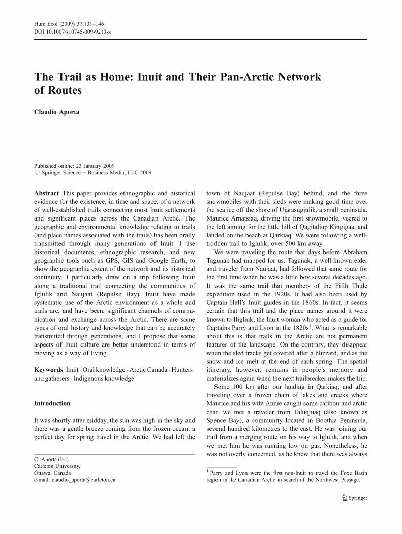
Figure 3 shows a more complete snapshot of Inuit trailsin Arctic Canada. While the trails to the west of MelvillePeninsula were mapped from a historical source (Stefáns-son 1912), the ones to the east are the result of mapping inseveral Inuit communities. The map shows a complexnetwork of trails connecting significant places across theArctic. Around the area of Aggu, a trail (Trail 1) branchesoff towards the Inuit community of Taluqjuaq in BoothiaPeninsula. Inuit from that region use this trail on their wayto Arctic Bay. There are also two trails (11 and 12) from theBoothia area to Repulse Bay and to Iglulik. From ArcticBay, at least two main trails (6 and 7) join that communitywith the settlement of Pond Inlet. Pond Inlet is, in turn,linked to Iglulik (Trail 8). From Pond Inlet and Iglulik,trails 9 and 10 traverse the intricate topography of BaffinIsland to the eastern community of Clyde River. FromClyde River, other trails go to more southern destinations,and so on. Inuit from Arctic Bay at times would also travelto Greenland (Ikummaq 2000; Mary-Rousselière 1980),and Inuit from Cape Dorset travel (mostly by boat) toNorthern Quebec.
8 For an in-depth look at Inuit sense of time, see MacDonald (1998).
9 The use of new technologies such as GPS and, especially, thesnowmobile, is creating the notion of trails as transitional placestowards a final destination (Aporta andHiggs 2005). The oral history andplace names, however, continue to reinforce the concept of lived trails.
Hum Ecol (2009) 37:131–146 135135

Figure 3 shows a clear picture of the network of trails thatconnect the communities included in this study, tracing theexistence of a pan-Arctic net of trails across lands and seas ofthe Inuit-inhabited Arctic. Each community could beconsidered a connecting point or hub for several trails. It is,therefore, no wonder that during the Fifth Thule ExpeditionMathiassen reported meeting Inuit who “knew the whole ofthe country between Chesterfield Inlet and Pond Inlet andhad also traveled to Piling, North Devon, Cornwallis Island,North Somerset and Prince of Wales Island” (Mathiassen1928: 97–98). Some of the Inuit encountered by Mathiassenwere clearly used to travelling over an immense territorythrough familiar, interconnecting trails.
Before the Canadian government encouraged Inuit tosettle in permanent communities, the Inuit sense of identity(or some of the dimensions of it) was often connected totraveling. There are many terms in Inuktitut that refer to thisconnection between Inuit and moving. Some examples ofthis connection are aullaaq (translated as “he is gone to along distance place with his family”), utirjariaq (“a travelerthat goes and is due to return in the same trip”), pagijjijut(“people left behind when the hunter was away on a longtrip”), and Kivavaan (“southbound”, referring to peopletraveling toward the Naujaat area).
The network of trails was connected to people’s sense ofidentity, as moving was for the Inuit part of life. It is,
therefore, understandable that the trails of this networkbecame known to the Fifth Thule expedition (see nextsection) as they traveled from Greenland to Alaska. It isalso easy to assume that the Inuit the expedition met in eachsettlement or camp would provide them with geographicinformation in the form of trails and place names. It is,indeed, possible to speculate that this network of trailsplayed a role in helping Inuit spread news, and sharelanguage, cosmologies, and material culture across theArctic.
Place Names
Since the knowledge of trails is oral, language becomescrucial in order to describe the features of the trail,significant landmarks or icemarks and direction of travel10.In the narrative of a journey, the trail is described in termsof what can be seen (or what will appear) on the horizon.When traveling over a flat expanse of tundra or sea ice, forexample, the appearance of a particularly shaped hill in acertain direction may determine a turning point of the trail.
Fig. 2 Trails between Arctic Bay and Iglulik
10 It should be noted that Inuit elders express concern related to theloss of Inuit knowledge (oral) due to the contemporary context of lifein the settlement, formal schooling, etc. One of the main reasons forInuit-supported oral history projects and mapping projects is to avoidthe loss of oral knowledge with the passing of knowledgeable elders.
136 Hum Ecol (2009) 37:131–146
Most often, such a hill is associated with a place name.Directions are usually connected with the prevailing windbearings, but also with other spatial referents such as theshores or the floe-edge (see Aporta 2003). In the context ofthe oral description of the territory place names become ofgreat importance, as precise geographic locations are oftenidentified with a toponym11.
Ujarasugjuk, for instance, is a well-known place inIglulik, and it refers to a submerged rock that constitutes adanger to boat travel off the western shore of the island;Maniiruarjuk is a rough area that Inuit try to avoid whiletraveling on the land; Tammariaq is a flat area around a trailwhere it is easy to make a mistake; Kinngakatannak is asmall, rounded hill that can be seen from a distance whiletraveling the trail. Inuit place names are associated with amyriad of topographic features, including rivers, creeks,lakes, valleys, hills, rocks, bays, and even ice features suchus polynyas and ice ridges (Aporta 2002).
The names of places were traditionally kept in people’smemories and transmitted in narratives. Their rendering on
topographic maps across the Canadian Arctic is a relativelyrecent event.12 The mapping of place names is in itself arevealing process, as it becomes immediately obvious thatthe elders participating in the sessions are picturing thefeatures from the perspective of a traveler or of someonewho is actually there looking at the features described.Many place names are intimately connected to travel, andmany of them are directly linked to trails. Iglunnguaraa-luuk, for instance, implies “two hills resembling iglus thatyou can see from the mainland, as they are the most visiblefeatures of the horizon” (field notes, Iglulik, 2006);Pusinngajuujaq is a hill that from a distance resembles abowl upside-down.
The importance of place names in Inuit culture hasbeen pointed out by several authors (MacDonald 1998;Collignon 1996; Brody 1981; Arima 1976; Boas 1888). Ihave elsewhere shown the connection between trails and placenames (Aporta 2004). The mapping of place names makesthis connection evident to the point that often the existenceof trails can be guessed just by knowing where the named
Fig. 3 Pan-Arctic network of trails
11 The place names do not involve discrete renderings of geographiclocations (comparable to a set of coordinates). The information istransmitted in the context of a larger narrative. In fact, names likeTasiujaq (big lake) are used to describe several features (lakes and insome cases other water features such as bays). What makes aparticular Tasiujaq unique is the context provided by the narrative.
12 Mapping projects are being conducted all across the Arctic, mainlybecause of the fear that some names will be forgotten when olderpeople pass away and also for political reasons, as a way of reclaimingthe land and recognizing the existence of Inuit names (see Müller-Wille 1983).
Hum Ecol (2009) 37:131–146 137137

places are. In other words, the spatial layout of the namessuggests the existence of a particular itinerary.
Figure 4 indicates the presence of a trail across thenorthern tip of Baffin Island. Through the use of thesenames, a narrator can describe a trail, identifying creeks,lakes, hills, portages, stone cairns, and landing spots. Theoral description of the trail (or the narrative of the journey)will help a listener picture how the horizon will look fromthe trail, and what kind of features a traveler should expect.
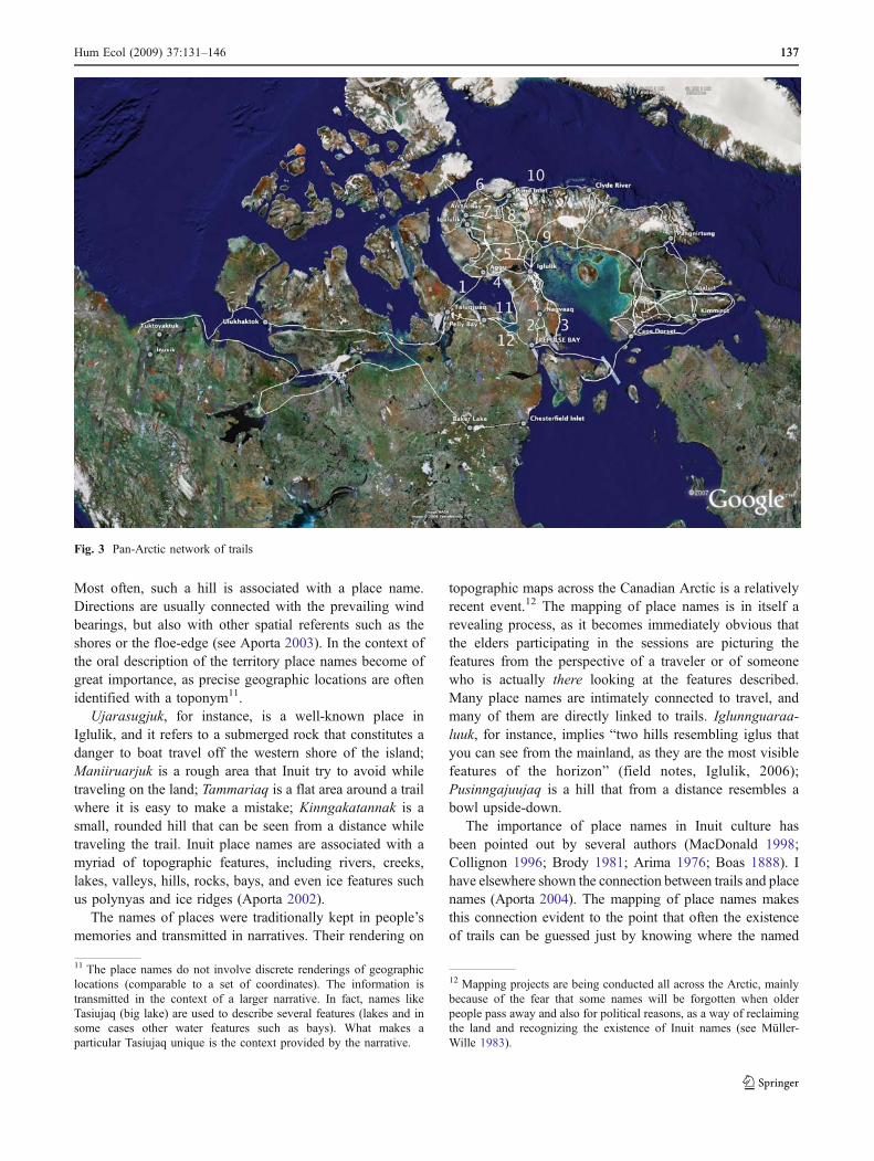
Figure 5 shows a number of trails and a selection of placenames from Naujaat, through Iglulik, to Arctic Bay and PondInlet. Trails and names were mapped in different mappingsessions over blank maps, but their relationship becameobvious when they were integrated as layers of the samedigital map. It is remarkable that every turning point, and everypoint where two or more trails merge or separate is named.
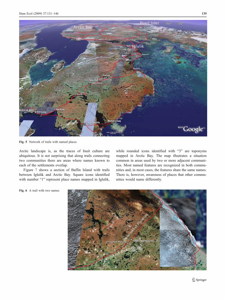
Not all Inuit place names are associated with trails, but itseems that the opposite is true: all Inuit trails are connectedto a sequence of place names. Names are extensively usedto designate hunting and fishing locations, the presence ofplants and berries, supernatural events, etc. Densely namedareas are indications of extensive use (see also Collignon1996). The network of trails connects current settlementswith these locations showing both the current use of theland and the old patterns of habitation (and a relationshipbetween the two). Inuit usually identify a trail or a variationof a trail with a particular name (generally the name of asignificant feature along the trail), and in some cases, trailsare given a name of their own.
Figure 6 shows an interesting case in the vicinity ofIglulik. This trail connecting the shore with the interior ofMelville Peninsula is known by two different names thatare used according to the direction of travel. UsuarjukkutKivavvaq is the name that people use for the trail as it istraveled from the shore towards Naujaat, and it is calledUsuarjukkut Pijuariaq for the opposite direction.
Experienced Inuit travelers may possess the knowledgeof several hundreds or even thousands of names, mostlyaround their settlements, hunting and fishing grounds andtrails. The range of their knowledge sometimes includesnames of distant places that are usually connected to longtrails. Place names play an important role in the way Inuittalk about their activities. The lack of that commonknowledge would certainly make travelers feel limited intheir discourse. Toponyms, indeed, occupy a very importantpart in any narrative of journeys13 and other events on theland.
Because traveling is such an important part of Inuitidentity, and considering that in the past Inuit were nomadicor seminomadic, there are names virtually everywhere thatInuit have dwelt and traveled. In fact, if we were to make amap of the Inuit-occupied Arctic that includes all the namesand trails, we would readily see how extensively used the
Fig. 4 Names suggesting a trail(part of the trail between Iglulikand Pond Inlet)
13 The newly created maps with local place names are in fact helpingnew Inuit migrants (usually government workers coming from otherNunavut communities) to adapt to the new place and the newcommunity faster, as they can learn names that otherwise would takea long process of personal connections.
138 Hum Ecol (2009) 37:131–146
Arctic landscape is, as the traces of Inuit culture areubiquitous. It is not surprising that along trails connectingtwo communities there are areas where names known toeach of the settlements overlap.
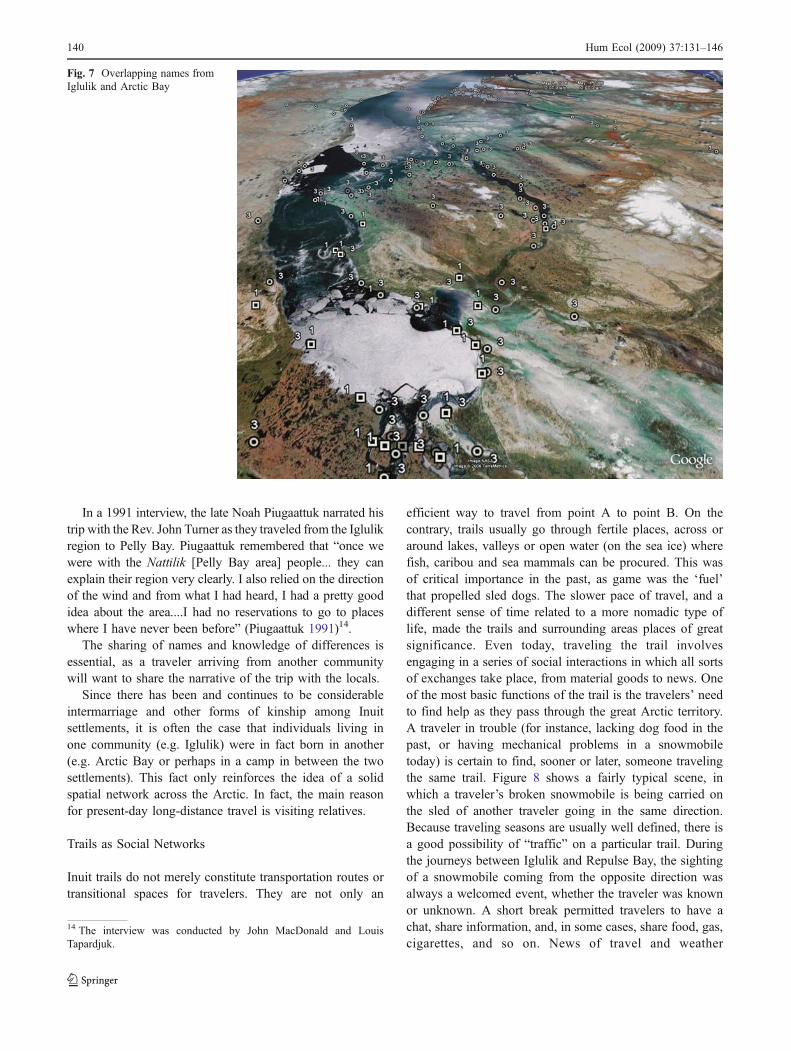
Figure 7 shows a section of Baffin Island with trailsbetween Iglulik and Arctic Bay. Square icons identifiedwith number “1” represent place names mapped in Iglulik,
while rounded icons identified with “3” are toponymsmapped in Arctic Bay. The map illustrates a situationcommon in areas used by two or more adjacent communi-ties. Most named features are recognized in both commu-nities and, in most cases, the features share the same names.There is, however, awareness of places that other commu-nities would name differently.
Fig. 6 A trail with two names
Fig. 5 Network of trails with named places
Hum Ecol (2009) 37:131–146 139139
In a 1991 interview, the late Noah Piugaattuk narrated histrip with the Rev. John Turner as they traveled from the Iglulikregion to Pelly Bay. Piugaattuk remembered that “once wewere with the Nattilik [Pelly Bay area] people... they canexplain their region very clearly. I also relied on the directionof the wind and from what I had heard, I had a pretty goodidea about the area....I had no reservations to go to placeswhere I have never been before” (Piugaattuk 1991)14.
The sharing of names and knowledge of differences isessential, as a traveler arriving from another communitywill want to share the narrative of the trip with the locals.
Since there has been and continues to be considerableintermarriage and other forms of kinship among Inuitsettlements, it is often the case that individuals living inone community (e.g. Iglulik) were in fact born in another(e.g. Arctic Bay or perhaps in a camp in between the twosettlements). This fact only reinforces the idea of a solidspatial network across the Arctic. In fact, the main reasonfor present-day long-distance travel is visiting relatives.
Trails as Social Networks
Inuit trails do not merely constitute transportation routes ortransitional spaces for travelers. They are not only an
efficient way to travel from point A to point B. On thecontrary, trails usually go through fertile places, across oraround lakes, valleys or open water (on the sea ice) wherefish, caribou and sea mammals can be procured. This wasof critical importance in the past, as game was the ‘fuel’that propelled sled dogs. The slower pace of travel, and adifferent sense of time related to a more nomadic type oflife, made the trails and surrounding areas places of greatsignificance. Even today, traveling the trail involvesengaging in a series of social interactions in which all sortsof exchanges take place, from material goods to news. Oneof the most basic functions of the trail is the travelers’ needto find help as they pass through the great Arctic territory.A traveler in trouble (for instance, lacking dog food in thepast, or having mechanical problems in a snowmobiletoday) is certain to find, sooner or later, someone travelingthe same trail. Figure 8 shows a fairly typical scene, inwhich a traveler’s broken snowmobile is being carried onthe sled of another traveler going in the same direction.Because traveling seasons are usually well defined, there isa good possibility of “traffic” on a particular trail. Duringthe journeys between Iglulik and Repulse Bay, the sightingof a snowmobile coming from the opposite direction wasalways a welcomed event, whether the traveler was knownor unknown. A short break permitted travelers to have achat, share information, and, in some cases, share food, gas,cigarettes, and so on. News of travel and weather
Fig. 7 Overlapping names fromIglulik and Arctic Bay
14 The interview was conducted by John MacDonald and LouisTapardjuk.
140 Hum Ecol (2009) 37:131–146

conditions, and of game and fish along the way, was alwaysexchanged. News about other travelers encountered on theway would also be passed on, and the trail becomes achannel where information flows back and forth as thepeople traveling it build and feel a sense of community.
The Network in Time: But How Old Are These Trails?
For this paper, interviews with Inuit elders and writtendocuments and maps have been used to compare present-daytrails and place names with those used by Inuit in the past.The most important sources to establish the historicalpermanence of this geographic knowledge and of this wayof using the territory were the historical maps and journalsproduced by the first explorers and ethnographers that visitedthe area. They all used the help of Inuit guides, and theydocumented some of the traditional routes and toponyms.
It is through these historical references that the temporalcontinuity of this oral knowledge can be better shown,particularly as the locations of place names and trails from his-torical records are digitized and combined with place names andtrails mapped through interviews and mapping sessions today.
A linguist might perhaps be able to determine theapproximate age of some place names, and an archaeologistcould date some of the trails (for example, through theanalysis of artifacts found along the way, or through datingcertain rock cairns along the route), but this is beyond thescope of this project. The purpose here is to show that aconsiderable number of trails and place names and theirgeographic locations have been used for a very long time.However, although a significant assumption of this paper isthat many of the trails and place names are very old, it isimportant to point out the limits of such a statement. TheInuit knowledge of their territory is dynamic and evolving(not unlike other types of knowledge). New place names
are sometimes created. Some new trails or segments oftrails are tried and some old ones are abandoned, as thestyle of life and means of transportation change.
Trail 3 in Fig. 3 shows the shore-route connectingNaujaat and Iglulik, which is barely used today since, aspreviously mentioned, snowmobile drivers favor the inlandroute (Trail 2). In the past, the shore route was oftenpreferred as it was easier to keep the icing of the sledrunners in good shape. That route also took travelersthrough several camps and hunting grounds along theshore. On the other hand, it is also said that youngertravelers using GPS units are sometimes coming up withstraighter (and often less efficient and more solitary) routes(Aporta andHiggs 2005). However, there is general agreementamong the Inuit I interviewed and traveled with that most ofthe routes and place names they use today were also used bytheir parents, grandparents, and as far back as they know.
Explorers, ethnographers, missionaries and traders thattraveled the Canadian Arctic in the 19th and first half of the20th centuries relied heavily on Inuit guides to obtaingeographic information. Explorers Parry and Lyon, the firstnon-Inuit to visit the Foxe Basin area hoping to make a wayto the Pacific, sought the help of Inuit to sketch what, tothem, was terra incognita. Other visitors, such as Hall,Mathiassen, Tremblay, and Rowley, employed Inuit asguides in their sled journeys, and recorded (in a non-systematic way) Inuit place names and routes. Some of theInuit who acted as guides or sources of information alsoturned into cartographers (see Spink and Moodie 1972),and produced a series of maps containing Inuit geographicknowledge and land use that can be compared with present-day data. Inuit guides grasped with different degrees ofsuccess the principles of western cartography (see Bravo1996), but most drawings present recognizable features,and some are remarkable in their similarity with contem-porary topographic maps. Inuit place names were alsorecorded by explorers and other travelers, but there was nosystematic mapping of place names in the region that is themain focus of this study. Comprehensive documentation ofplace names was done by Boas in southern Baffin Island(Boas 1888; Müller-Wille and Barr 1998) and by Petitot inthe western Canadian Arctic (Petitot 1889; Wonders 1987).The names were written phonetically and they are some-times difficult to compare with today’s standardizedInuktitut writing system. This was aggravated by the factthat some of these travelers had little or no knowledge ofInuktitut (and, in turn, Inuit did not have any knowledge ofthe explorer’s language).15 It is possible, however, to
Fig. 8 A snowmobiler gets help along the trail between Iglulik andNaujaat
15 It should also be noted that Parry’s journal was published (andperhaps edited) by the Admiralty, while Hall’s work was edited andpublished by the US Government Printing Office in Washington, D.C.,after his death.
Hum Ecol (2009) 37:131–146 141141
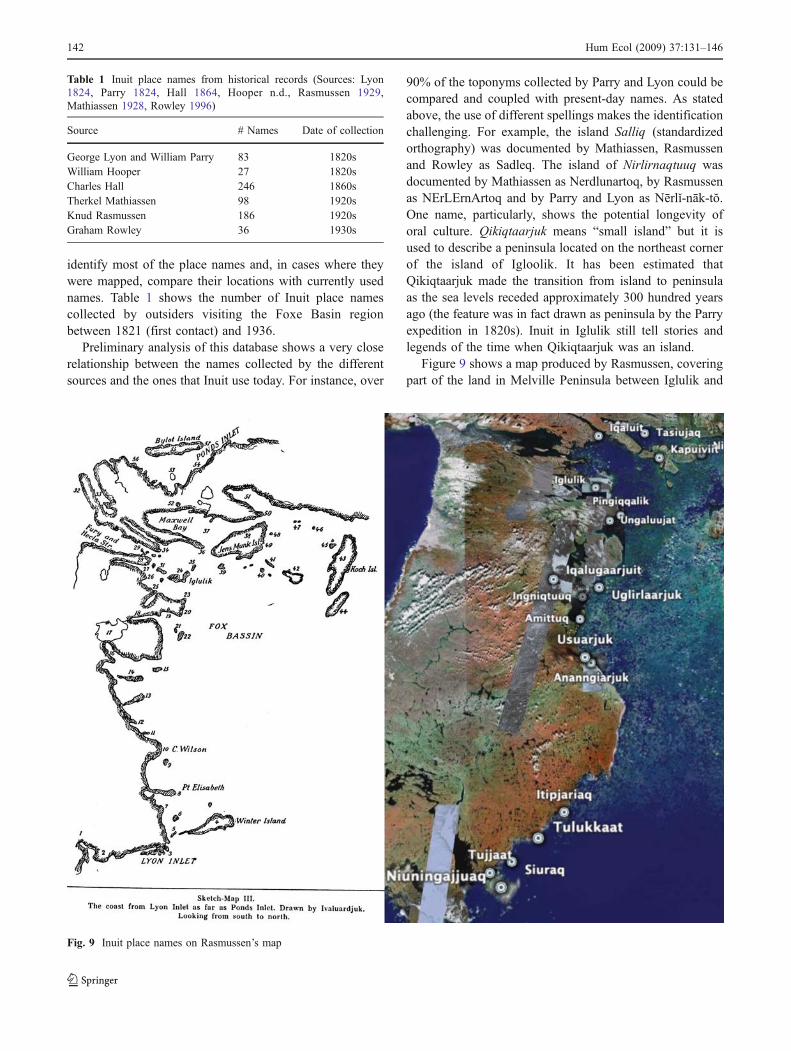
identify most of the place names and, in cases where theywere mapped, compare their locations with currently usednames. Table 1 shows the number of Inuit place namescollected by outsiders visiting the Foxe Basin regionbetween 1821 (first contact) and 1936.
Preliminary analysis of this database shows a very closerelationship between the names collected by the differentsources and the ones that Inuit use today. For instance, over
90% of the toponyms collected by Parry and Lyon could becompared and coupled with present-day names. As statedabove, the use of different spellings makes the identificationchallenging. For example, the island Salliq (standardizedorthography) was documented by Mathiassen, Rasmussenand Rowley as Sadleq. The island of Nirlirnaqtuuq wasdocumented by Mathiassen as Nerdlunartoq, by Rasmussenas NErLErnArtoq and by Parry and Lyon as Nērlǐ-nāk-tŏ.One name, particularly, shows the potential longevity oforal culture. Qikiqtaarjuk means “small island” but it isused to describe a peninsula located on the northeast cornerof the island of Igloolik. It has been estimated thatQikiqtaarjuk made the transition from island to peninsulaas the sea levels receded approximately 300 hundred yearsago (the feature was in fact drawn as peninsula by the Parryexpedition in 1820s). Inuit in Iglulik still tell stories andlegends of the time when Qikiqtaarjuk was an island.
Figure 9 shows a map produced by Rasmussen, coveringpart of the land in Melville Peninsula between Iglulik and
Table 1 Inuit place names from historical records (Sources: Lyon1824, Parry 1824, Hall 1864, Hooper n.d., Rasmussen 1929,Mathiassen 1928, Rowley 1996)
Source # Names Date of collection
George Lyon and William Parry 83 1820sWilliam Hooper 27 1820sCharles Hall 246 1860sTherkel Mathiassen 98 1920sKnud Rasmussen 186 1920sGraham Rowley 36 1930s
Fig. 9 Inuit place names on Rasmussen’s map
142 Hum Ecol (2009) 37:131–146

Naujaat. Virtually all the place names shown on the map arestill used today to refer to the same features. The explorersusually documented the routes over areas of personalinterest, or around places where they actually traveled (inmost cases following their Inuit guides). Remarkably, whenInuit were asked to draw the maps themselves they almostalways included trails, as if they could not imagine or picturethe territory without them. In the context of this research,these trails were digitized and incorporated as layers of a GISdatabase. Overlapping these trails with currently used routesand place names shows unmistakable continuity over time.
Figure 10 shows the route mapped by Iligliuk for Parryin 1821. This same route was mapped by Inuit elders inIglulik and Naujaat (Trail 3 in Fig. 3). The GIS databasereveals that this traditional route is clearly connected toplace names currently used in both communities.
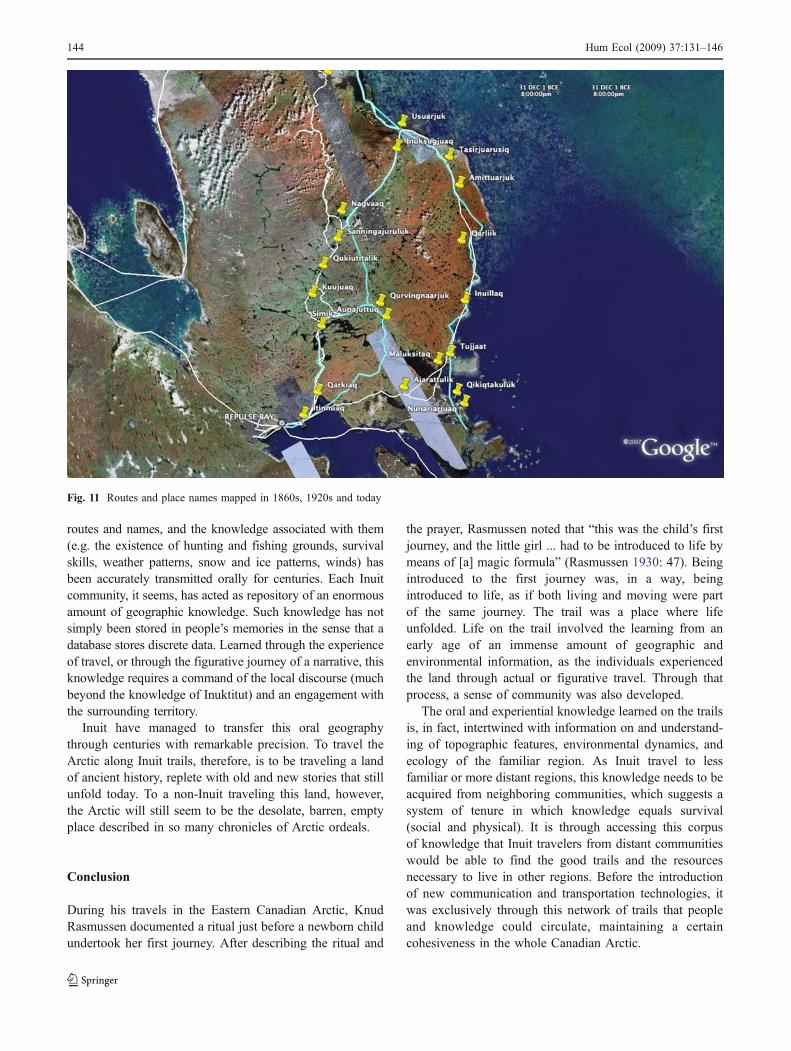
Figure 11 shows the routes used by Hall in the 1860s andby members of the Fifth Thule Expedition in the 1920s. Theseroutes are represented as light green lines on the map. Most ofthe segments of the routes used by Hall and the Fifth Thule
expedition are the same, and they also coincide with routescurrently used and mapped by the author (represented as whitelines on the map). When incorporated in the database, theyboth connect closely to present-day routes and place names,showing historic continuity since the mid nineteenth century.
The map on the left of Fig. 12 shows the route betweenIglulik and Pond Inlet drawn for Claude Vigneau by anInuk identified as Nookudla (Speck 1924). The drawingwas made in 1923, but Nookudla was remembering a triphe had undertaken with Tremblay in 1913. The map to theright shows two variations of the present-day trail drawn byTheo Ikummaq in Iglulik in 2006. The easternmostvariation is virtually identical to Nookudla’s trail.
The examples shown in Figs. 9, 10, 11 and 12 are only asmall sample of the data compiled in this research. All seem toindicate the unmistakable historical continuity of routes andnames. If we consider that the names and routes were alreadytraditional at the time of the explorers’ visits to Foxe Basin,the longevity of such knowledge can be assumed to be greaterthan the first records. This shows that the precise locations of
Fig. 10 Iligliuk’s route (1821) and currently used place names
Hum Ecol (2009) 37:131–146 143143
routes and names, and the knowledge associated with them(e.g. the existence of hunting and fishing grounds, survivalskills, weather patterns, snow and ice patterns, winds) hasbeen accurately transmitted orally for centuries. Each Inuitcommunity, it seems, has acted as repository of an enormousamount of geographic knowledge. Such knowledge has notsimply been stored in people’s memories in the sense that adatabase stores discrete data. Learned through the experienceof travel, or through the figurative journey of a narrative, thisknowledge requires a command of the local discourse (muchbeyond the knowledge of Inuktitut) and an engagement withthe surrounding territory.
Inuit have managed to transfer this oral geographythrough centuries with remarkable precision. To travel theArctic along Inuit trails, therefore, is to be traveling a landof ancient history, replete with old and new stories that stillunfold today. To a non-Inuit traveling this land, however,the Arctic will still seem to be the desolate, barren, emptyplace described in so many chronicles of Arctic ordeals.
Conclusion
During his travels in the Eastern Canadian Arctic, KnudRasmussen documented a ritual just before a newborn childundertook her first journey. After describing the ritual and
the prayer, Rasmussen noted that “this was the child’s firstjourney, and the little girl ... had to be introduced to life bymeans of [a] magic formula” (Rasmussen 1930: 47). Beingintroduced to the first journey was, in a way, beingintroduced to life, as if both living and moving were partof the same journey. The trail was a place where lifeunfolded. Life on the trail involved the learning from anearly age of an immense amount of geographic andenvironmental information, as the individuals experiencedthe land through actual or figurative travel. Through thatprocess, a sense of community was also developed.
The oral and experiential knowledge learned on the trailsis, in fact, intertwined with information on and understand-ing of topographic features, environmental dynamics, andecology of the familiar region. As Inuit travel to lessfamiliar or more distant regions, this knowledge needs to beacquired from neighboring communities, which suggests asystem of tenure in which knowledge equals survival(social and physical). It is through accessing this corpusof knowledge that Inuit travelers from distant communitieswould be able to find the good trails and the resourcesnecessary to live in other regions. Before the introductionof new communication and transportation technologies, itwas exclusively through this network of trails that peopleand knowledge could circulate, maintaining a certaincohesiveness in the whole Canadian Arctic.
Fig. 11 Routes and place names mapped in 1860s, 1920s and today
144 Hum Ecol (2009) 37:131–146

The access or sharing of this knowledge takes place innarratives. Such narratives will involve the description ofvisual features, often named, the availability of animals, theconditions of snow and ice, the shape of snowdrifts and thedirection of prevailing winds. The layout of such informa-tion is given within a geographic framework constituted bythe wind compass and other spatial referents. This sharingwas critical in the past, but it is still present today. Iglulik’sTheo Ikummaq, for example, relied on information provid-ed by Arctic Bay elders in order to make a trip to thenorthern part of Greenland. The elders were able to describethe landscape and the ice and snow conditions in minutedetail, even though they had made the trip many yearsearlier (Ikummaq 2000). While today Inuit can learn fromwritten sources and from maps, the social dimensions oftravel and life in the Arctic still require such learningexperiences. After returning from the long dog-sled tripbetween Iglulik and Greenland, Ikummaq was invited tonarrate his trip on the local radio station, which he did overthe course of three days.
It seems clear that the spoken word can be a reliablemeans of knowledge sharing, and that oral history shouldnot be a priori dismissed as unreliable and inaccurate. Thegeographic knowledge of trails and names that Inuit havetransmitted without significant changes over the centuriesoffers evidence of the power of oral communication thatmay perhaps be extended to other realisms of Inuitknowledge, and even to other cultures that rely on oraltraditions. For the Inuit, trails were and are a distinctive
aspect of their own cultural identity. The dramatic socialand cultural consequences that sedentarization brought tothe Inuit (Rasing 1994) could perhaps be better understoodwhen the differences between life in town and life on thetrail are acknowledged.
Acknowledgements The main source of funding for this researchwas a grant from the Committee for Research and Exploration of theNational Geographic Society. Additional sources included a CarletonUniversity Startup Grant and travel funds provided by the InuitHeritage Trust for mapping of place names. Some of the work done inIglulik and Cape Dorset received support from an IPY Canada grant(Project ISIUOP), and from NSTP (Northern Scientific TrainingProgram). The Igloolik Research Centre (Nunavut Research Institute)provided considerable support during most of this research. JohnMacDonald and his wife Carolyn were exceptional hosts in Iglulik.John also provided critical help in the organization of the trip toNaujaat, and he offered crucial feedback and constructive critique onearlier drafts of this paper. Conversations with John through manyyears helped developed some of the ideas expressed in this paper. Akey person in this research was Maurice Arnatsiaq, who guided thetrip between Iglulik and Naujaat, aided with interviews and mapping,and helped me understand the importance of Inuit travel. Severalelders in all the communities the research took place collaborated inproviding geographic information. Of those, the key participants wereHerve Paniaq in Iglulik, and Abraham Tagunak and Maliki in Naujaat.Theo Ikummaq, in Iglulik, also provided critical information andhelped with interviews and translations. This research also benefitedfrom the work of several graduate and undergraduate students atCarleton University who helped with data collection (Kelly Karpallaand Karen Kelley) and data analysis (Allison Berman, Ana Fonsecaand Andrew Black). Timothy Di Leo Browne helped in editing thispaper. Finally, I would like to thank the reviewers of the journal,whose critiques and suggestions made this paper better.
Fig. 12 Route between Iglulikand Pond Inlet used in 1913 andtoday
Hum Ecol (2009) 37:131–146 145145

References
Aporta, C. (2002). Life on the Ice: Understanding the Codes of aChanging Environment. Polar Record 38(207): 341–354.
Aporta, C. (2003). Using GPS Mapping Software to Map Inuit PlaceNames and Trails. Arctic 56(4): 321–327.
Aporta, C. (2004). Routes, Trails and Tracks: Trail-Breaking Amongthe Inuit of Igloolik. Études Inuit Studies 28(2): 9–38.
Aporta, C. (2005). From Map to Horizons; from Trail to Journey: TheChallenges of Documenting Inuit Geographic Knowledge.Études Inuit Studies 29(1–2): 221–231.
Aporta, C., and Higgs, E. (2005). Satellite Culture: Global PositioningSystems, Inuit Wayfinding, and the Need for a New Account ofTechnology. Current Anthropology 46(5): 729–754.
Arima, E. (1976). An assessment of the reliability of informant recall.In Freeman M. M. R. (ed.), Inuit Land Use and OccupancyProject, Indian and Northern Affairs, Ottawa. Vol. 2, pp. 31–38.
Asch, M., and Zlotkin, N. (1997). Affirming Aboriginal title: a newbasis for comprehensive claims negotiations. In Asch, M. (ed.),Aborginal and Treaty Rights in Canada: Essays on Law, Equality,and Respect for Difference. UBC, Vancouver, pp. 208–230.
Attwood, B. (2005). Telling the Truth About Aboriginal History. Allenand Unwin, Crows Nest, NSW (Australia).
Boas, F. (1888). The Central Eskimo. Bureau of Ethnology,Washington.
Bravo, M. (1996). The Accuracy of Ethnoscience: A Study of InuitCartography and Cross-Cultural Commensurability. ManchesterPapers in Social Anthropology, Manchester.
Brody, H. (1981). Maps and Dreams. Douglas & McIntyre Ltd.,Vancouver.
Collignon, B. (1996). Les Inuit: ce qu’ils savent du territoire.L’Harmattan, Paris.
Fortescue, M. (1988). Eskimo Orientation Systems. Meddelelser ømGrønland, Man and Society 11. Commission for ScientificResearch in Greenland, Copenhagen.
Hall, C. F. (1864). Life with the Esquimaux. Sampson Low, Son, andMarston, London.
Hooper, W. H. (n.d.). The Unpublished Journal of William HarveyHooper, National Archives, Ottawa.
Ijjangiaq, M. (1990). IE-478. Archives of the Inullariit Society.Igloolik Research Centre, Igloolik, Nunavut.
Ikummaq, T. (2000). IE-478. Archives of the Inullariit Society.Igloolik Research Centre, Igloolik, Nunavut.
Lyon, G. F. (1824). The Private Journal of Captain G. F. Lyon of H.M.S. Hecla During the Recent Voyage of Discovery Under CaptainParry. John Murray, London.
Macdonald, J. (1998). The Arctic Sky: Inuit Astronomy, Star Lore,and Legend. Nunavut Research Institute, Iqaluit; The RoyalOntario Museum, Toronto.
Mary-Rousselière, G. (1980). Qitdlarssuaq: l’histoire d’une migrationpolaire. Les Presses de l’université de Montréal, Montréal.
Mathiassen, T. (1928). Material Culture of the Iglulik Eskimos. Reportof the Fifth Thule Expedition, Vol. 6 (1), GyldendalskeBoghandel, Nordisk Forlag, Copenhagen.
McGhee, R. (1969–1970). Speculations on Climatic Change andThule Culture Development. Folk 11–12: 173–184.
Morrison, D. (1999). The Earliest Thule Migration. Canadian Journalof Archaeology 22: 139–153.
Müller-Wille, L. (1983). Inuit toponymy and cultural sovereignty. InMüller-Wille, L. (ed.), Conflict in Development in Nouveau-Québec. McGill Centre of Northern Studies and Research,Montréal, pp. 131–150.
Müller-Wille, L. (ed.) and Barr, W. (tr.). (1998). Franz Boas among theInuit of Baffin Island, 1883–1884: Journals and Letters,University of Toronto Press, Toronto.
Parry, W. E. (1824). Journal of a Second Voyage for the Discovery ofa Northwest Passage from the Atlantic to the Pacific. JohnMurray, London.
Petitot, É., père. (1889). Quinze ans sous le cercle polaire Mackenzie,Anderson, Youkan, E. Dentu, Paris.
Piugaattuk, N. (1991) Interview for Igloolik Oral History Project.Archives of the Inullariit Society, Igloolik Research Centre (IE-170).
Rasing, W. C. E. (1994). Too Many People: Order and Noncon-formity in Iglulingmiut Social Process. Rish & Samenleving,Nijmegen.
Rasmussen, K. (1929). Intellectual Culture of the Iglulik Eskimos. InReport of the Fifth Thule Expedition, Vol. 7 (1), GyldendalskeBoghandel, Nordisk Forlag, Copenhagen.
Rasmussen, K. (1930, 1976). Iglulik and Caribou Eskimo Texts. InReport of the Fifth Thule Expedition, Vol. 7 (3), AMS, NewYork.
Rowley, G. W. (1996). Cold Comfort: My Love Affair with the Arctic.McGill-Queen’s University Press, Montreal.
Speck, F. G. (1924). Eskimo Collection from Baffin Land andEllesmere Land. Indian Notes 1(3): 143–149.
Spink, J., and Moodie, D. W. (1972). Eskimo maps from the CanadianEastern Arctic. Cartographica, Monograph No. 5.
Stefánsson, V. (1912). My Life with the Eskimo. Harcourt, Brace andCompany, New York.
Wonders, W. C. (1987). Native Claims and Place Names in Canada’sWestern Arctic. The Canadian Journal of Native Studies 7(1):111–120.
146 Hum Ecol (2009) 37:131–146