the upgrade of the m50 in the context of an integrated ... · synopsis: this paper presents an...
TRANSCRIPT
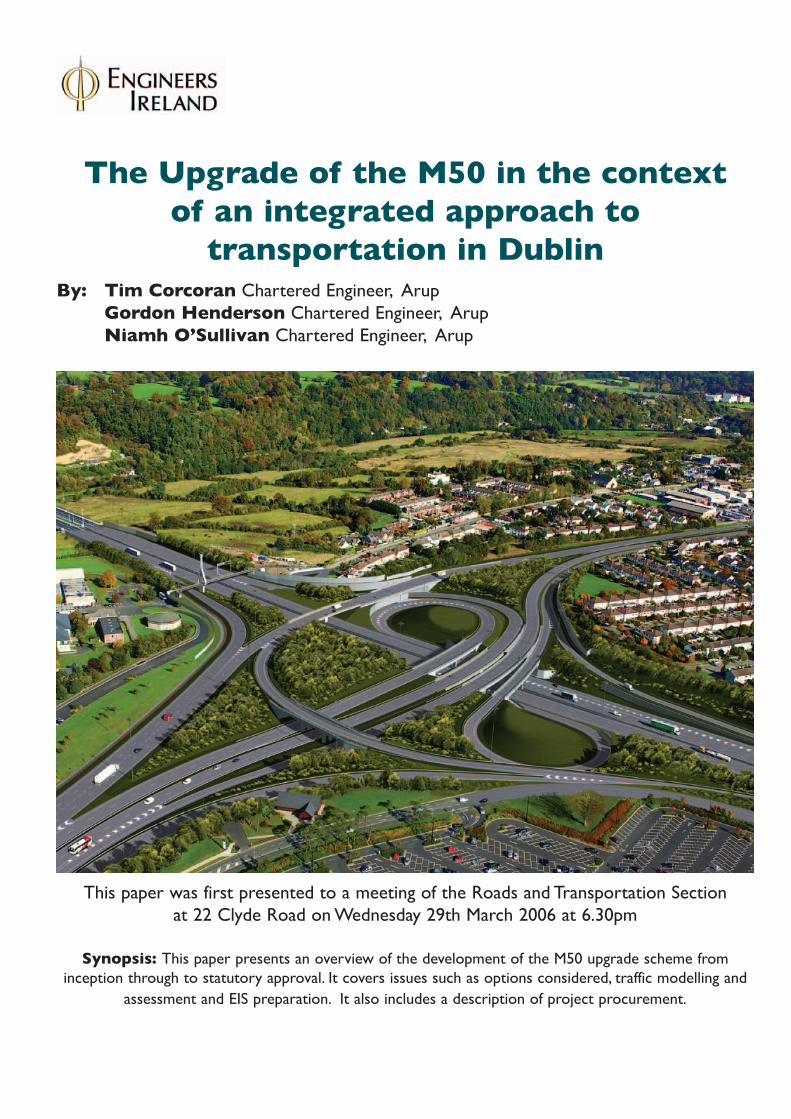
The Upgrade of the M50 in the context of an integrated approach to
transportation in DublinBy: Tim Corcoran Chartered Engineer, Arup
Gordon Henderson Chartered Engineer, Arup Niamh O’Sullivan Chartered Engineer, Arup
This paper was first presented to a meeting of the Roads and Transportation Section at 22 Clyde Road on Wednesday 29th March 2006 at 6.30pm
Synopsis: This paper presents an overview of the development of the M50 upgrade scheme from inception through to statutory approval. It covers issues such as options considered, traffic modelling and
assessment and EIS preparation. It also includes a description of project procurement.

2
M50 Upgrade
Index
Background
IntroductionHistory of M50Existing M50Policy and Planning Context
Scheme Development
• Outline Methodology• DTO Transportation Model• General Approach to
Transport Assessment• Operational Performance
Criteria• Implications of Do Minimum
Scenario• Development of the
Scheme
Proposed Scheme
Do Something ScenarioEffects of M50 UpgradeProposed SchemeDesign StandardsCost Benefit AnalysisProject Procurement
Statutory Procedures
Public ConsultationEnvironmental Impact StatementLand and Property IssuesOral Hearing
Comparison with SchemeObjectives
Acknowledgement
Background
Introduction
Arup commenced a study on the M50Upgrade Scheme in 2000 with a briefto “maximise the capacity of the builtportion of the “C” ring (M1 to M81) bymeasures such as the provisionthroughout its length of an additionallane in each direction, the incorporationof noise and amelioration measures,the identification of necessary modifi-cations to interchanges and the possi-ble applications of telematics.” It alsorequired Arup to “examine the capacityof the remaining section of the M50”,from N81 to N11, and “to recommendthe measures necessary to balanceand complement the identified andagreed development necessary tomaximise the capacity of the builtportion of the “C” ring”.
As the M50 traverses the local authori-ty areas of Fingal, South Dublin andDun Laoghaire Rathdown and DublinCity, a Steering Committee with a rep-resentative from each local authority
was established to guide the ArupStudy Team. The NRA and the DTOwere also represented on the SteeringCommittee. Arup and the SteeringCommittee reviewed the brief, expand-ing the study to look at alternatives towidening.
The study took place in the period2000 – 2004 with the scheme develop-ment being put on hold midwaythrough the process, pending fundingapproval. Extensive optioneering, trafficanalysis and public consultation wereundertaken and an EIS prepared. AnOral Hearing took place in December2004 / January 2005 and the construc-tion of the upgrade scheme is beingprogressed under both Design andBuild and PPP Contracts.
This paper describes the schemedevelopment from initial brief throughto completion of the Oral Hearing andbriefly outlines how the construction isbeing procured.
M50 Route

3
M50 Upgrade
History of M50
The existing M50 is a result of overthree decades of planning and construction during the period in whichDublin and indeed Ireland have experi-enced unprecedented growth andchange. The first section of the motor-way to be constructed was the WesternParkway, which opened in 1990. TheNorthern Cross and Southern Crossfollowed in 1996 and 2001, respective-ly. The final section, the South EasternMotorway opened in 2005, Figure 1.
Traffic and economic growth are generally highly correlated and theM50 is no exception. The M50 hasexperienced compound traffic growthrates of between 8% and 10% on mostsections in the period between 1997and 2003, Figure 2.
The M50 was originally conceived asan orbital route to carry longer distance strategic traffic around andaway from the city centre. It is also themost significant crossing of the RiverLiffey and one of the few outside theurban centre of Dublin. The M50’sstrategic function will increase in impor-tance with the opening of the DublinPort Tunnel and it will continue toprovide access to strategic facilitiessuch as Dublin Airport and Dublin Port. However, in addition to its strategicfunction and as a result of the growthin development along the corridor, theexisting M50 now performs a morelocal function connecting residentialand commercial centres on and adja-cent to the corridor as well as cateringfor commuting traffic.
Although the implementation of theDTO “A Platform for Change Strategy”will provide more and better alterna-tives to the car for short distance localtrips as well as commuters, the M50 islikely to maintain its multi-functionalrole even if, in the case of non-strate-gic traffic, this is reduced.
Existing M50
The M50 was designed as a dual 2-lane motorway with a wide median,facilitating a later upgrade to a dual 3-lane motorway. However statutoryapproval for the construction to dual 2-lane motorway standards only wasreceived at that time. The design istypical of that of a rural motorway witha wide median and hard shoulders.The existing M50 generally has 2 x3.75 m lanes in each direction with a
hard shoulder up to 3.0m wide. TheNorthern Cross, Western Parkway andSouth Eastern Motorway sections havea design speed of 120 kph, while theSouthern Cross section has a designspeed of 100 kph.
The M50 crosses the River Liffey at theWestlink Bridge between the N3 andN4 interchanges. The original bridgewas constructed as a 4 lane bridge (2lanes in each direction). A secondbridge was constructed in 2003 andthe two bridges combined now provide3 lanes in each direction. This sectionof the M50 was procured as a PublicPrivate Partnership (PPP) project withthe concessionaire, National Toll Roads(NTR) collecting direct tolls at theWestlink Toll Plaza.
The existing Westlink Toll Plaza islocated immediately north of theWestlink Bridges and has seven lanesand toll booths in each direction. Thereare currently three payment methodsavailable including manual collection(where change is given), automaticcoin machines and a pre-pay electronictag system (Eazy Pass).
The M50 has interchanges with mostof the main radial routes leading intoDublin City Centre. The nationalprimary and secondary interchangesconsist of grade separated four-legroundabouts, generally over the M50except at the N2 where it is locatedunder the M50. The other interchangesare similar or consist of grade separat-ed four-leg dumbbell style inter-changes.
The increase in traffic growth on theM50 and change in travel patterns overrecent years have given rise to signifi-cant capacity challenges. The mainissues are:• Congestion on many interchanges
and on the mainline;• Difficulty for traffic merging onto
the mainline;• Queues on merge and diverge
slip lanes;• Congestion on the approaches to
the Toll Plaza;particularly in peak periods.
M50 Section Location Opening Year
Western Parkway and
Westlink Toll Plaza
N3 Interchange – N81 Interchange
inclusive
1990
Northern Cross M1 Interchange – N3 Interchange 1996
Southern Cross N81 Interchange – Ballinteer Interchange 2001
Second Westlink Bridge Between N3 and N4 Interchanges 2003
Southern Eastern Motorway Ballinteer Interchange to M11 at Shankill 2005
Figure 1 History of M50
Figure 2 AADT in PCUs
4
M50 Upgrade
Policy and Planning Context
The M50 is part of the national roadnetwork of Ireland and traversesthrough the Local Authority areas ofFingal, South Dublin and DunLaoghaire-Rathdown and Dublin City.The development of the M50 is there-fore important in a national, regionaland local planning context.
The M50 Motorway plays an importantrole at a national level due to its scale,function and location. Dublin is thecapital city of Ireland and a third of thetotal population of Ireland reside in theGreater Dublin Area (GDA) .
Considerable employment, shoppingand community services for the countryare also located in the Greater DublinArea. Planning policy on a nationallevel includes the NationalDevelopment Plan (NDP), 2000-2006and the National Special strategy. TheNDP, under the Strategy for Transportin the Greater Dublin Area, includesprovision for the widening of the C-ring(M50) to three lanes, together withimprovements to the interchanges.
Policy and planning documentationwas drawn up for the Greater DublinArea to guide development, takingplace as a result of the unprecedentedgrowth in population, housing, trafficvolumes, etc. The M50 Motorway playsa very important role in traffic flowbetween Dublin and adjacent Counties.Planning and policy documentation rel-evant at a regional level includes:• Strategic Planning Guidelines for
the Greater Dublin Area (SPGGDA), 1999
• A Platform for Change Strategy 2000 – 2016
• Regional Planning Guidelines Greater Dublin Area (RPGGDA) 2004
The Strategic Planning Guidelines forthe GDA were prepared to provide acoherent strategic planning frameworkfor the local authority DevelopmentPlans and for the provision of majortransportation, sanitary services andother infrastructure.
In September 2000, the DTO published“A Platform for Change Strategy 2000-2016” (DTO Strategy) - outlining itstransport strategy for the period 2000– 2016. A final report was published inNovember 2001. This strategy supportsand complements the strategic landuse planning framework described in
the SPGGDA. The strategy comprisestwo interdependent elements, firstinfrastructure and service improve-ments and secondly demand manage-ment. Infrastructure and serviceimprovements are proposed to“increase the supply of transport,including substantial expansion of thepublic transport network (includingLUAS, Metro, DART and bus services),some strategic road construction andtraffic management”. It includes“upgrading and completion of theorbital motorway around Dublin (M50,Dublin Port Tunnel and Eastern By-Pass)” and “upgrading the arterialnational routes outside the orbitalmotorway”. It is included asGovernment Policy in the Transport 21initiative.
The RPGGDA were adopted in July2004 and supersede the SPGGDA.This is the first regional policy docu-ment which is designed to implementthe provisions of the National SpatialStrategy at a regional level. The M50widening and interchange improve-ments are listed as a key strategicnational road infrastructure project.
Scheme Development
Outline Methodology
Development of the M50 UpgradeScheme involved an initial assessmentof the alternatives to upgrading theM50. The option of doing nothing wasdeemed unacceptable as the trafficcongestion on the M50 is predicted toworsen in the future despite the imple-mentation of public transport proposals(such as the Luas and Metro), roadimprovements and demand manage-ment strategies as proposed in theDTO Strategy for Dublin.
Alternative major road schemes wereinvestigated including:• provision of a new outer orbital
route• a new connection to the M50
between the existing N4 and N7 interchanges via a possible new M7.
• the provision of a new link road between the N2 and N3 as a possible measure to reduce traffic congestion at the N3 interchange and therefore minimise the need for improvements at this interchange.
In addition to the major alternative roadschemes, a range of other alternativemeasures were examined. Theseincluded:• the use of the third lane as a
dedicated orbital facility for buses and taxis.
• A number of low cost traffic management measures, including partial use of the hard shoulder at specific locations and extension of some merging lanes, to alleviate problems at specific locations on the M50.
• Minor M50 interchange improvements such as improved signalisation, further segregated left turn lanes, traffic management and bridge widening to provide additional lane capacity, in conjunction with provision of a third lane in both directions
After consideration of each alternativeit was determined that none of theseoptions would realistically provide asolution that would offer the same ben-efits and alleviate the need for upgrad-ing the M50. Hence upgrading theexisting M50 infrastructure was select-ed as the preferred option.
An incremental approach was taken tothe design of each component of theM50 Upgrade Scheme. The approachinvolved examining at first minorupgrades, and then increasing in incre-ments until one or more schemes metthe design criteria of improving capaci-ty, whilst taking account of the environ-mental, economic and physical siteconstraints. Dedicated pedestrian andcyclist facilities were also incorporatedinto the Scheme design.
DTO Transportation Model
The DTO Transportation Model wasthe principal traffic design and analysistool used in the development of theDTO Strategy for Dublin. It has beenand continues to be a consistent basisupon which to provide transport fore-casts for use in the evaluation of majorinfrastructure proposals in the GreaterDublin Area. The model was used forthe evaluation of both Luas and theDublin Port Tunnel as well as for thedevelopment of a strategy for the pro-posed Eastern Bypass. The model hasbeen used in developing the proposedM50 Upgrade Scheme. Since the origi-nal development of the model in theearly 1990s, it has been extended,modified and upgraded many times toreflect the growth of Dublin along withnew development and traffic trends.

5
M50 Upgrade
The model has a number of strengthsthat make it well suited to carrying outthis type of transportation analysis. Among these are:• The model is multi-modal and as
such is able to take into account the relative attractiveness of all motorised modes of surfacetransport (car, heavy goods vehicles, bus and rail) in trip making decisions.
• The highway assignment model takes full account of junction delays caused by congestion and the impacts of this congestion on bus travel. Recent improvements to the highway model have involved extending the model network to include parts of Kildare, Wicklow and Meath, as well as extension of the highway simulation model outside the M50.
• The model establishes a realistic mode choice based on the relative perceived ‘generalised’costs of a given trip by the modes available to the trip maker. This cost is determined by applying a monetary value to both the time and distance elements associated with any trips. In performing this mode split, the cost of trips by car varies with the level of congestion on the road network.
• The model covers the entire Dublin Urban Area and takes into account trips to and from regions of the country outside this area.
• The DTO Transportation Model was used to predict both peak hour and inter peak hour flows for the forecast years 2008 and 2023.
The model incorporates all of the trans-port proposals, which comprise theintegrated transportation strategy forthe Dublin area as outlined in the DTOStrategy. In demographic terms, thetransportation model forecasts incorpo-rate population and household projec-tions based on the development planssupplied by the seven Local Authoritiesin the Greater Dublin Area (Fingal,South Dublin, Dun LaoghaireRathdown, Dublin City, Kildare, Meathand Wicklow), as well as estimates ofpopulation growth for the region fromthe Strategic Planning Guidelines.Projections of employment were basedon land zoned for future developmentand other related information suppliedby the local authorities and the DTO.
The DTO Transportation Model is regu-larly updated and refined to maintainits currency. Earlier iterations of this
upgrade scheme for the M50 weredeveloped between 2000 and 2002using the version of the model avail-able at that time. The proposals putforward in this scheme were reviewedas part of a design development exer-cise and a number of the interchangelayouts were considered. In the inter-vening period the model was updatedand further refined. The preferredScheme was reassessed in 2003 andearly 2004 using the new model.
General Approach to TransportAssessment
The purpose of the transportationassessment was to quantify the effectof the proposed Scheme particularly interms of its operational performance,value for money and its effect on thetransport network in Dublin. The trans-port network includes all motorisedtransport modes such as cars, busesand commercial vehicles and rail. Theassessment also provides the neces-sary traffic data for use in the environ-mental assessment, particularly for thenoise, air quality, climate and commu-nity assessment aspects.
With regard to operational perform-ance, consideration was given to theproposed improvements for both inter-change and mainline capacity and theresulting benefits in reduced traffic con-gestion that these would bring to theM50 corridor and the wider roadnetwork. Value for money wasassessed by undertaking a cost benefitanalysis which weighed the monetaryvalue of savings in travel time, fuelconsumption and accidents, etc.against the capital cost of the Schemeand its future maintenance costs.
Importantly, the transportation assess-ment also evaluated and quantified theimpact of the Scheme on public trans-port modes both in the M50 corridorand the Greater Dublin Area. Demand management has not beenincorporated as part of the current pro-posals. However it is anticipated that itwill be implemented as required afteropening of the Scheme.
The objective of the M50 UpgradeScheme is to improve the capacity ofthe M50 within the context of an inte-grated transportation strategy forDublin. In order to establish the infra-structure provision necessary to meetthis objective a basic methodology wasestablished. The steps in the method-ology were:
Comprehensive traffic surveys wereundertaken on the M50 and its inter-changes to identify the location andscale of traffic congestion problems onthe existing M50. Many of the prob-lems were identified as being connect-ed with capacity constraints at theinterchanges and merging slip lanes aswell as at the Toll Plaza.
The Dublin Transportation Office (DTO)Transportation Model was consideredto be the most appropriate traffic fore-casting tool and was used to quantifythe scale of future traffic volumes onthe M50 and its interchanges in theforecast years 2008 (year of opening)and 2023 (design year) if nothing wasdone (Do-Minimum Scenario).
Having quantified the scale of trafficgrowth in the Do-Minimum Scenario,strategic and off-line alternatives suchas parallel routes, a new orbital route,as well as other measures such as adedicated bus/ taxi lane were considered.
On concluding that these alternativeswould not meet the project objectives,the transportation model was used toassess the benefits of on-line schemesspecifically addressing the traffic issuesidentified in the Do-Minimum Scenario.These schemes, which included thewidening of the main line to three lanesin both directions and interchangeupgrades, formed the basis of theScheme (Do-Something Scenario).
An iterative design process followed inwhich the proposals were continuouslyrefined and evaluated to optimise theproject objectives and to minimise theenvironmental impact within the physi-cal constraints of the corridor. TheScheme that evolved was progressedto preliminary design stage, and isreferred to as the Do-SomethingScenario.
The process of identifying a solution tothe M50 capacity problems was an iter-ative one, in which the performance ofalternative designs for the interchangesand mainline were compared with theDo-Minimum Scenario in future years.The evaluation was conducted bymaking use of traffic performance crite-ria for the mainline and interchanges.
Do-Minimum ScenarioThe Do-Minimum Scenario encapsu-lates all elements of the existing Dublintransportation network as well as thetransport infrastructure commitments of
6
M50 Upgrade
the DTO Strategy, except for the M50Upgrade Scheme. It provides a meansof quantifying the extent of future trafficcongestion on the existing M50 as wellas a benchmark against which to eval-uate and compare the possibleupgrade options. Specifically the Do-Minimum Scenario comprised the fol-lowing:
• Existing dual 2-lane carriageway on the M50.
• Existing M50 interchange configurations.
• Agreed improvements to the radial routes outside the M50.
• All other measures and proposals included in the DTO Strategy for the two forecast years 2008 and 2023.
The proposed Eastern Bypass, whichwill connect Sandyford to the DublinPort Tunnel, is a longer-term proposalassumed to be completed after 2008,which would potentially have a signifi-cant impact on traffic flows on theSouthern Cross Route and SouthEastern Motorway sections of the M50.
In addition, it was anticipated that, atthe time of opening of the upgradedM50 in 2008, legislation will be in placeto allow the concessionaire to replacethe existing toll plaza with a free-flowelectronic toll collection system basedon a combination of electronic tagreaders sited on overhead gantries andnumber plate recognition.
Do-Something ScenarioThe Do-Something Scenario for eachof the design years 2008 and 2023was based on the widening of the M50to dual 3-lane motorway between theM1 and Sandyford together with auxil-iary lanes between the M1 andScholarstown and associated inter-change upgrades. The public trans-port and other infrastructure proposalscontained in the DTO Strategy, whichare anticipated to be completed andoperational by each forecast year, werealso included in this Scenario.
Operational Performance Criteria
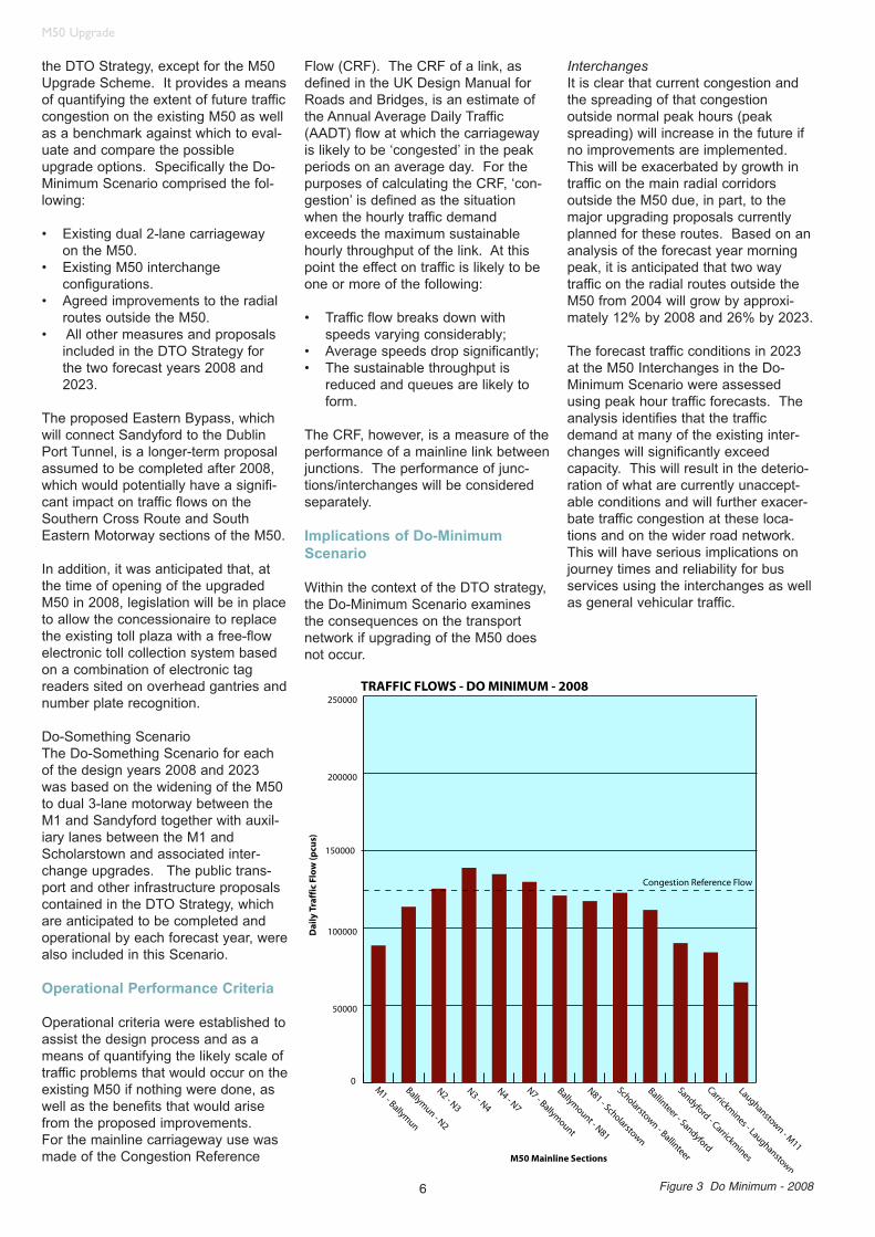
Operational criteria were established toassist the design process and as ameans of quantifying the likely scale oftraffic problems that would occur on theexisting M50 if nothing were done, aswell as the benefits that would arisefrom the proposed improvements. For the mainline carriageway use wasmade of the Congestion Reference
Flow (CRF). The CRF of a link, asdefined in the UK Design Manual forRoads and Bridges, is an estimate ofthe Annual Average Daily Traffic(AADT) flow at which the carriagewayis likely to be ‘congested’ in the peakperiods on an average day. For thepurposes of calculating the CRF, ‘con-gestion’ is defined as the situationwhen the hourly traffic demandexceeds the maximum sustainablehourly throughput of the link. At thispoint the effect on traffic is likely to beone or more of the following:
• Traffic flow breaks down with speeds varying considerably;
• Average speeds drop significantly;• The sustainable throughput is
reduced and queues are likely to form.
The CRF, however, is a measure of theperformance of a mainline link betweenjunctions. The performance of junc-tions/interchanges will be consideredseparately.
Implications of Do-MinimumScenario
Within the context of the DTO strategy,the Do-Minimum Scenario examinesthe consequences on the transportnetwork if upgrading of the M50 doesnot occur.
InterchangesIt is clear that current congestion andthe spreading of that congestionoutside normal peak hours (peakspreading) will increase in the future ifno improvements are implemented.This will be exacerbated by growth intraffic on the main radial corridorsoutside the M50 due, in part, to themajor upgrading proposals currentlyplanned for these routes. Based on ananalysis of the forecast year morningpeak, it is anticipated that two waytraffic on the radial routes outside theM50 from 2004 will grow by approxi-mately 12% by 2008 and 26% by 2023.
The forecast traffic conditions in 2023at the M50 Interchanges in the Do-Minimum Scenario were assessedusing peak hour traffic forecasts. Theanalysis identifies that the trafficdemand at many of the existing inter-changes will significantly exceedcapacity. This will result in the deterio-ration of what are currently unaccept-able conditions and will further exacer-bate traffic congestion at these loca-tions and on the wider road network.This will have serious implications onjourney times and reliability for busservices using the interchanges as wellas general vehicular traffic.
Figure 3 Do Minimum - 2008

7
M50 Upgrade
Mainline CarriagewayThe development of the mainlinewidening and its extent was based onan assessment of future traffic condi-tions on the existing M50, i.e. the Do-Minimum Scenario and in the knowl-edge that sections of the mainline arefrequently congested at present.The results of this analysis are illustrat-ed in Figure 3 for the year of opening,2008 using the Annual Average DailyTraffic Flow (AADT). The figure alsoincorporates the Congestion ReferenceFlow (CRF), which in the figure relatesto a dual 2-lane carriageway.
There are a number of importantfactors which will affect the relativegrowth on individual sections of theM50 in the future:
• Sections currently operating at or around capacity are likely to experience lower levels of traffic growth due to these capacity constraints.
• The implementation of public transport infrastructure, particularly in the longer term, will have a dampening effect on traffic growth by encouraging modal shift.
• The implementation of major roads infrastructure, e.g. Eastern Bypass, will have an impact on the distribution of traffic on sections of the M50.
Taking the above into account, it canbe seen from Figure 3 that many sec-tions of the M50 will be operatingaround or above capacity by 2008.
Combined with the capacity limitationsat the interchanges and at some of themerging and diverging motorway sliproads, the growth in traffic predicted inthe Do-Minimum Scenario will furtherexacerbate the current traffic conges-tion problems on the motorway and itsapproach roads.
Using the CRF threshold as an initialguide in assessing the potential needfor the widening of each section of theM50, the forecast traffic flows in Figure3 show that in 2008 traffic flows onmany of the existing sections of theM50 will be at or considerably inexcess of the threshold.
Based on the 2008 traffic forecastsalone widening of the M50 to threelanes is justified between Ballymun andSandyford. In terms of the strategicintegrity of the M50, however, it wouldnot be appropriate to exclude the short
section between the M1 and Ballymun(and hence access to Dublin PortTunnel and Dublin Airport) from thewidening proposals.
Development of the Scheme
The development of the Schemerequired the preparation of outlinedesigns for the mainline and inter-changes, incorporating facilities forVulnerable Road Users (VRUs) suchas pedestrians and cyclists.
The design process for increasing thecapacity of the M50 within the contextof an integrated transportation strategyfor Dublin was an iterative one combin-ing inputs from a diverse team ofexperts. Having established the objec-tive of the study and formulated thetransportation assessment methodolo-gy, the various team members thencombined to develop a design whichachieved the Scheme objectives whiletaking into account environmental,community, engineering and economicissues.
The design development for the M50Upgrade Scheme occurred mainly overthe period between 2000 and 2004with the Scheme development beingput on-hold mid-way through theprocess pending funding approval. Asa result, a preliminary upgrade schemefor the M50 was developed between2000 and 2002 using the DTO TrafficModel current at that time with forecasttraffic design years of 2006 and 2016.The Scheme proposals were pro-gressed between 2003 and 2004 and anumber of the interchange layoutswere re-considered. The proposedScheme was then tested using the newDTO model with forecast traffic designyears of 2008 and 2023. The openingyear of 2008 was also considered to bea more achievable target opening year.
As before, the new DTO traffic modelassumes that the proposals in the DTOStrategy will be delivered by 2016.The traffic volumes forecast in the2023 DTO Traffic Model are generallyhigher than those predicted in the 2016Traffic Model. Therefore the Do-Minimum and design iteration assess-ments were not repeated as part of thedesign development.
Mainline WideningThe development of the mainlinewidening and its extent was based onan assessment of future flows if theScheme was not implemented, i.e. the
Do-Minimum as described earlier. It isproposed that the M50 be widened to 3lanes in each direction between the M1and Sandyford.
Of significant benefit to the mainlinewidening of the M50 is the width ofcentral median that generally allows forcentral widening. Therefore, it is possi-ble to provide an additional third laneusing mainly the existing medianwithout a requirement for more land foradditional lanes.
A detailed review of all bridges overand under the M50 followed to estab-lish any constraints in terms of widthand clearance available for widening.The main constraint identified duringthis review was the arched bridges atthe N3, which have sufficient width toaccommodate only three carriagewaylanes and a sub standard hard shoul-der. Other constraints that were con-sidered in the process include existingdrainage, utilities, noise and lighting.
A further influencing factor on themainline cross section was theweaving movements from the pro-posed interchange schemes. The fore-cast increase in traffic flows and asso-ciated weaving movements generateda need to extend the length of on- andoff-ramps at the interchanges. Giventhe close proximity of the M50 inter-changes and to facilitate safe merging,it was concluded that these slip lanesshould be extended to form auxiliarylanes between the M1 andScholarstown Interchanges. It shouldbe noted that the auxiliary lanes do notcontinue through the interchangesthemselves. Auxiliary lanes are current-ly provided on the M50 between the N7and Ballymount and between the N81and Scholarstown interchanges.
Following an iterative process of exam-ining a range of alignments, stoppingsight distances and design speedswithin the constraints identified, ascheme with a design speed of100km/h was adopted.
Interchange UpgradesAn incremental approach was taken tothe development of the interchangeupgrade options for the scheme. Thedesign process was based on anunderstanding of the physical and envi-ronmental constraints at the locationand an understanding of the futuretraffic movements, which was based onthe DTO model traffic forecasts and onexisting traffic survey data.
8
M50 Upgrade
The process, which involved examiningat first minor upgrades, then increasingin scale of improvement until one ormore schemes meets the design crite-ria. The initial minor upgrades identi-fied possible improvements such asthe revision of lane markings, the intro-duction of traffic signals or further seg-regated left turn lanes. If these did notachieve the design criteria objectivesthen more substantial measures wereconsidered including bridge wideningand in the case of the N2, N3, N4 andN7 Interchanges, the possible con-struction of radial flyovers across theinterchanges. At the N7 Interchangethe design proposals also had to opti-mise the performance of the inter-change incorporating the operation ofthe Luas. At most of the major inter-changes the provision of free-flowturning movements on some or all ofthe links was utilised to achieve thedesign objectives.
At an early stage, radial flyovers of theM50 were considered but were reject-ed as they did not accommodate theprojected future traffic flows containingsignificant left and right turns on andoff the M50. In addition, the radial fly-overs were generally not considered tobe environmentally acceptable as theyadded a third level to the interchanges.
Due to the urban location of the M50,the interchange sites are constrainedby existing adjacent development.Traditional free flow interchangedesigns were, therefore, not appropri-ate. Alternative compact interchangedesigns were developed, based onexperience from similar constrainedinterchanges in Australia and else-where.
All options were considered and com-pared in the context of the following: • environmental effects• cost• future flexibility• integration with public transport• buildability• construction disturbance• land take
With all interchange upgrades theselected layout takes account of theexisting interchange structures andseeks to provide the additional infra-structure necessary through the inte-gration of new elements with the exist-ing elements. This has the advantageof minimising the extent of new con-struction with the subsequent advan-tages of efficiency, speed of construc-
tion, minimisation of traffic disturbanceand reduced construction impacts.
Proposed Scheme
Do-Something Scenario
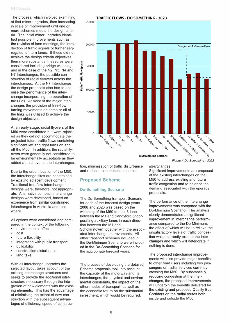
The Do-Something transport Scenariofor each of the forecast design years2008 and 2023 was based on thewidening of the M50 to dual 3-lanebetween the M1 and Sandyford (incor-porating auxiliary lanes in each direc-tion between the M1 andScholarstown) together with the associ-ated interchange improvements. Allother transport schemes included inthe Do-Minimum Scenario were includ-ed in the Do-Something Scenario forthe appropriate forecast years.
The process of developing the detailedScheme proposals took into accountthe capacity of the motorway and itsinterchanges, the physical and environ-mental constraints, the impact on theother modes of transport, as well asthe economic return on the substantialinvestment, which would be required.
InterchangesSignificant improvements are proposedat the existing interchanges on theM50 to address existing and futuretraffic congestion and to balance thedemand associated with the upgradeproposals.
The performance of the interchangeimprovements was compared with theDo-Minimum Scenario. The analysisclearly demonstrated a significantimprovement in interchange perform-ance compared to the Do-Minimum,the effect of which will be to relieve theunsatisfactory levels of traffic conges-tion which currently exist at the inter-changes and which will deteriorate ifnothing is done.
The proposed interchange improve-ments will also provide major benefitsto other road users including bus pas-sengers on radial services currentlycrossing the M50. By substantiallyreducing congestion at the inter-changes, the proposed improvementswill underpin the benefits delivered bythe existing and proposed Quality BusCorridors on the radial routes bothinside and outside the M50.
Figure 4 Do Something - 2023

9
M50 Upgrade
The interchange improvements and theprovision of high standard merges anddiverges combined with the provisionof an auxiliary lane in both directionsbetween most of the interchanges willsignificantly improve accessibility to themotorway for general traffic and for busservices. The auxiliary lane, by provid-ing a longer distance for merging withthe main line carriageway, will improvesafety by providing improved mergingfacilities.
Mainline CarriagewayThe forecast daily traffic flows (AADT)on the Scheme in 2023 are providedin Figure 4.
Even with the higher traffic forecastson the Scheme, the widened mainlinecarriageway will result in improved per-formance levels as measured by %CRF on the majority of sections of theM50 but particularly on the mostheavily trafficked sections between theN3 and Ballinteer. This, combinedwith the reduction in traffic congestionresulting from the main interchangeimprovements is reflected in the majoreconomic benefits discussed later.
The improved performance levels onthe M50 are also reflected in increasedjourney speeds associated with theScheme where on average, theScheme improves peak hour trafficspeeds on the M50 by 10 kph (19%) in2008 and 6 kph (11%) in 2023.
The above performance analysis,however, is a conservative one basedon the assumption that the auxiliarylanes on both carriageways betweenthe M1 and Scholarstown do not con-tribute to the operational capacity ofthe mainline carriageway due to therelatively close proximity of the M50interchanges. In practice, however, theproposed auxiliary lanes will have apositive effect on mainline capacity byimproving the efficiency of merging anddiverging traffic and by allowing somediverging traffic to exit earlier, thusreducing the traffic flow on the main-line.
Whilst wider demand managementmeasures incorporated in the DTOStrategy have been taken into accountin the production of the traffic forecastsusing the model, specific measuresrelated to the M50 have not.To ‘lock in’ the benefits arising from thismajor asset, it will, therefore, be neces-sary to implement more specificdemand management measures tocontrol the level of traffic growth on the
motorway. The need for and theprecise form these measures will takewill be considered in a separate study.
Effects of M50 Upgrade
Radial RoutesThe M50 Upgrade Scheme will sub-stantially reduce traffic congestion onthe radial routes approaching themotorway from outside the M50, henceimproving access to the motorway, par-ticularly during peak hour. This effectis illustrated clearly in Figure 5 whichcompare the average traffic speeds inthe Do-Minimum and Do-SomethingScenario in the morning peak hour forboth 2008 and 2023. Similarlyimproved access will also be experi-enced by traffic travelling to the M50from radial routes inside the motorway. The cumulative effect for traffic on
radial routes travelling through the M50junctions towards the city is howeverlargely neutral. The M50 UpgradeScheme will therefore improve accesson to and off the motorway without significantly affecting journey times fortraffic travelling into the city centre andis consistent with DTO policy, whichseeks to discourage any increase incommuting by car to Dublin city centreand to encourage the use of alternativetransport modes. In this situation theexisting and proposed Quality BusCorridors on the radial routes intoDublin City Centre will continue toprovide a realistic and attractive alternative for many commuters.
Other RoadsThe improved traffic conditions on theprincipal radial routes together withreduced congestion at the M50
0
10
20
30
40
50
60
M1
R10
8N2
N3
N4
N7
Ballym
ount N
81
Sch
olar
stow
n
Sp
ee
d (
kp
h)
DoMinimumRadial Route
Photomontage of Proposed M1
Figure 5 - 2008

10
M50 Upgrade
interchanges and additional capacityon the M50 itself, are also expected todeliver a reduction in traffic volumes onthe majority of other roads.
Modal ShiftAn aim of the DTO Platform forChange Strategy is to produce a majorchange in modal shift away from use ofthe private car, in favour of publictransport in the Greater Dublin Area.Upgrading of the M50 is an integralpart of the DTO Strategy and as such itis recognised that it will have someeffect on the demand for other modes,providing substantial increased capaci-ty for vehicular traffic. However,assessment shows that this increasedcapacity will have minimal impact onmodal split. Demand management onthe M50, as proposed in the DTOStrategy would, likely have a positiveimpact on modal split.
Quality Bus NetworkThe DTO Strategy regards buses asthe most flexible form of public trans-port, which can be implemented quicklyand effectively. The Strategy thereforerecommended a Quality Bus Network(QBN), which is made up of QualityBus Corridors (QBCs) with the attrib-utes of extensive bus priority meas-ures, continuous high frequencythroughout the day, new high qualityvehicles and improved infrastructures(shelters etc.).
In the design of the M50 UpgradeScheme, specific allowance for dedi-cated (physical) bus lanes has notbeen provided within the main inter-changes. The principal reason for thisdesign assumption is that once con-structed, there will be greatly improvedcapacity at the interchanges reducingcongestion. This will significantlyimprove journey times and reliability forall traffic including bus services. TheScheme therefore will reinforce thebenefits of the existing and proposedQBCs on radial routes into Dublin CityCentre ensuring that they provide arealistic, reliable and attractive alterna-tive for many commuters.
Luas: Connolly to Tallaght LineIn the upgraded N7 interchangescheme the Luas line crosses the roadlayout at approximately the currentlocations. The crossings will be atgrade, as before, and will be signalcontrolled. The signal timings will bedesigned to provide similar Luas tramcrossing frequency as for the existingroad. The scheme will, therefore,
support the benefits of the Luas lineproviding a realistic, reliable and attrac-tive alternative for many commuters.
The Wider Effects on CongestionThe implementation of the Scheme willhave far reaching benefits and will sig-nificantly reduce traffic congestion onthe whole of the Dublin road network.
As forecast by the DTO Model, trafficspeeds on the city-wide network in themorning peak hour in 2008 are predict-ed to increase from 21.7kph in the Do-Minimum to 23.7kph with the Scheme,an increase of 9%. An increase of12% is also forecast in off-peak trafficspeeds in 2008. These are very signif-icant improvements in the context ofthe overall Dublin road network andagain will benefit all road based trans-port including buses.
Proposed Scheme
The M50 Upgrade Scheme comprisesthe upgrade of 31km of the M50 main-line to dual 3-lane motorway standardsbetween the M1 and the SandyfordInterchanges together with the upgradeof 10 interchanges along this length asdescribed below. Pedestrian andcyclist facilities have been provided atall interchanges, except the M1Interchange, as part of the M50Upgrade Scheme.
It is proposed to widen the M50 main-line through the addition of a third lanein each direction. This will generally becarried out within the existing centralmedian. In order to facilitate merging
interchange traffic, an auxiliary weavinglane will be provided between inter-changes on the section between theM1 and Scholarstown Interchanges.There are currently auxiliary lanes onthe M50 between the N7 andBallymount and the N81 andScholarstown Interchanges.
To facilitate access on and off themotorway seven interchanges willreceive major upgrades involving thereconfiguration of the interchanges toinclude full or partial free flow lanes.
M1 Interchange - The M1 Interchangewill provide free flow lanes for allM50/M1 traffic movements. The inter-change is grade separated with the M1mainline passing underneath the M50.The existing roundabout will be main-tained as a signalised roundabout toaccommodate N32 traffic. Three newbridges will be constructed. This is amotorway-to-motorway interchange sofacilities for pedestrians and cyclistsare not provided at this location.
N2 Interchange - The interchange willbe upgraded to a partially free flowinginterchange. The interchange is gradeseparated with the M50 mainlinepassing over the N2. The existingbridges over the roundabout will be re-used and a further four new roadbridges and one new pedestrian/cyclistbridge will be constructed.
N3 Interchange - The interchange willbe upgraded to a partial free flowinginterchange. The interchange is gradeseparated with the M50 mainlinepassing underneath. The bridges on
Proposed N3 Interchange
11
M50 Upgrade
the existing roundabout will be re-usedand a further fifteen new road bridgesand two new pedestrian/cyclist bridgeswill be constructed. The Interchangelayout will generally separate nationaland local traffic and will upgradeaccess to Blanchardstown.
N4 Interchange - The interchange willbe upgraded to a completely freeflowing interchange. The interchangeis grade separated with the M50 main-line passing underneath. The twoexisting bridges will be re-used and afurther four new road bridges and onenew pedestrian/cyclist bridge will beconstructed. In addition one existingpedestrian bridge will be reconstructedas a pedestrian/ cyclist bridge.
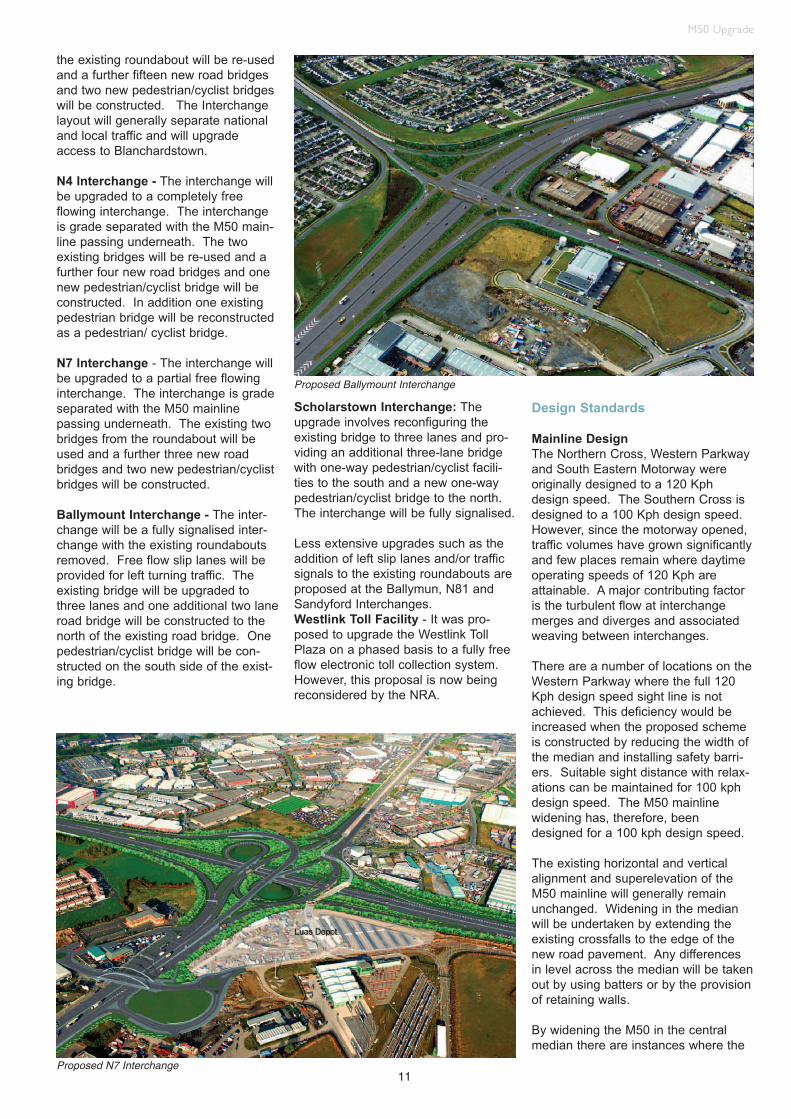
N7 Interchange - The interchange willbe upgraded to a partial free flowinginterchange. The interchange is gradeseparated with the M50 mainlinepassing underneath. The existing twobridges from the roundabout will beused and a further three new roadbridges and two new pedestrian/cyclistbridges will be constructed.
Ballymount Interchange - The inter-change will be a fully signalised inter-change with the existing roundaboutsremoved. Free flow slip lanes will beprovided for left turning traffic. Theexisting bridge will be upgraded tothree lanes and one additional two laneroad bridge will be constructed to thenorth of the existing road bridge. Onepedestrian/cyclist bridge will be con-structed on the south side of the exist-ing bridge.
Scholarstown Interchange: Theupgrade involves reconfiguring theexisting bridge to three lanes and pro-viding an additional three-lane bridgewith one-way pedestrian/cyclist facili-ties to the south and a new one-waypedestrian/cyclist bridge to the north.The interchange will be fully signalised.
Less extensive upgrades such as theaddition of left slip lanes and/or trafficsignals to the existing roundabouts areproposed at the Ballymun, N81 andSandyford Interchanges. Westlink Toll Facility - It was pro-posed to upgrade the Westlink TollPlaza on a phased basis to a fully freeflow electronic toll collection system.However, this proposal is now beingreconsidered by the NRA.
Design Standards
Mainline DesignThe Northern Cross, Western Parkwayand South Eastern Motorway wereoriginally designed to a 120 Kphdesign speed. The Southern Cross isdesigned to a 100 Kph design speed.However, since the motorway opened,traffic volumes have grown significantlyand few places remain where daytimeoperating speeds of 120 Kph areattainable. A major contributing factoris the turbulent flow at interchangemerges and diverges and associatedweaving between interchanges.
There are a number of locations on theWestern Parkway where the full 120Kph design speed sight line is notachieved. This deficiency would beincreased when the proposed schemeis constructed by reducing the width ofthe median and installing safety barri-ers. Suitable sight distance with relax-ations can be maintained for 100 kphdesign speed. The M50 mainlinewidening has, therefore, beendesigned for a 100 kph design speed.
The existing horizontal and verticalalignment and superelevation of theM50 mainline will generally remainunchanged. Widening in the medianwill be undertaken by extending theexisting crossfalls to the edge of thenew road pavement. Any differencesin level across the median will be takenout by using batters or by the provisionof retaining walls.
By widening the M50 in the centralmedian there are instances where the
Proposed N7 Interchange
Proposed Ballymount Interchange

ments within the junction layouts. Thedesign, therefore, has tried to achievea balance between maintaining appropriate combination of horizontalgeometry, design speed and superele-vation. Where changes in speed environment have been identified, thedesign aims to provide, where possi-ble, a progressive increase/decrease inspeed through the junction.
Design speeds have been selectedafter an assessment of the existingconstraints and the anticipated speedenvironment. Drivers are currentlyrequired to stop or travel at low speedswithin the existing interchanges due tohigh traffic volumes causing congestion.
As there will be the introduction of lowspeed geometry (loops) suitable acceleration and deceleration lengthswill be provided to and from the main-line. Gantry signs will also be providedto give drivers’ advance warning ofapproaching geometry and advice onappropriate operating speeds.
The design speeds generally beingadopted are shown in Table 1.
The majority of interchanges along theM50 present particular difficulties forthe provision of desirable minimumhorizontal standards. The designapproach was to provide maximumfeasible horizontal curves as part of acoordinated design approach, andwhere required, relaxations and depar-tures requested.
The interchanges were also designedtaking account of advice contained inTA43/03, particularly, driver comfortand gross lateral acceleration. Whereloop geometry has been applied, it is inaccordance with TD22/92 andTD40/94.
12
M50 Upgrade
design standards need the applicationof a relaxation. These generally relateto reductions in stopping sight distanceresulting from the inclusion of a safetybarrier in the central median.
From the M1 to Scholarstown an addi-tional auxiliary lane in each directionwill be provided between interchanges,to improve the weaving opportunitiesand provide a better level of service atmerges and diverges. Variations fromthis cross section are required in somesections of the mainline.
Interchange DesignThe interchange concepts have beendeveloped using the Design Manual forRoads and Bridges (DMRB) as pub-lished by the NRA. Specifically the fol-lowing documents have been used:
TD 22/92 - Layout of Grade Separated Junctions
TD 39/94 - Layout of Major Interchanges
TD 40/94 - Layout of Compact Grade Separated Junctions
TD 42/95 - Geometric Design of Major/Minor Priority Junctions
TD 50/99 -The Geometric Layout of Signal Controlled Junctions and Signalised Roundabouts
TD 9/03 - Road Link DesignTA 43/03 -Guidance on Road Link
DesignTD 27/00 -Cross Sections and
Headroom
Other international standards and doc-uments have also been consulted.These include:• CALTRANS Highway Design
Manual (Californian standards - USA),
• TACATC – Geometric Design Guide for Canadian Roads,
• Department of Main Roads (Queensland Australia), and
• Determination of Interchange Types on Freeway Facilities – Paper by Joel Leisch.
These standards have also been usedin assessing road safety and determin-ing suitable design parameters such asdesign speeds and stopping sight dis-tances.
At the main radial routes, the need tominimise the land take has resulted ina more compact form of junction thanwould be used for a new build motor-way. It has been the objective of thedesign to maintain an appropriatedesign speed for each of the align-
The interchange links have generallybeen designed for a speed of 50 kph.However, there are some locationswhere the constraints have necessitat-ed the inclusion of tighter horizontalgeometry and in these cases a lowerdesign speed has been adopted.
The following standards have beenadopted for superelevation: See Table 2.
A maximum superelevation of 5% hasgenerally been adopted to reduce therisk of large slow vehicles slippingduring icy conditions.
The rollover between different superel-evations is traditionally provided overthe length of a transition curve.However TD 40/94 does not requirethe inclusion of transition curves withina compact interchange. For thisproject, straights between curves havegenerally been incorporated withininterchanges to provide geometry overwhich the rollover can take place.
Lane widths have generally beendesigned as Table 3.
With the introduction of low radii geom-etry, the lanes have been widened asnecessary to provide adequate sweeppaths for large vehicles in accordancewith Table 7/2 of TD42/95.
In an attempt to standardise the outershoulder and hard strip widths withinthe interchanges, they have generallybeen designed with widths of 1.5 mand 0.5 m respectively. Radial roadshave generally been designed to eithermatch existing or with a 2.5 m nearsideshoulder and a 1 m hard strip.
Verge widths have generally beenmaintained at 3 m on both sides of theroadway. However, in constrainedlocations and on slip roads the vergehas been reduced to 1.5 m. Where itis necessary to achieve the requiredsight stopping distances, widening of
Table 1 Desirable Design Speeds
Table 3 Lane Widths
Table 2 Superelevation Standards
Location Design Speed (Kph)
Mainline 100
Slip-Roads 70
Interchange Links 50
Loops 30 (min)
Type Superelevation
Minimum 3%
Desirable Maximum 5%
Location Width
Main Line 3.50m desirable: 3.25m minimum
Connecting Radial 3.65m
Interchange Links 1 lane 4.00m
Interchange Links 2 lanes 3.65m desirable: 3.50m minimum

13
M50 Upgrade
the verges and outer shoulders / hardstrips has been undertaken.
Vertical geometry has been designedto conform to the requirements ofTD9/03 Table 3. Where grades areabove the maximum grades as docu-mented in the standards, a departurehas been requested.Diverges and merges have beendesigned for a mainline design speedof 100 kph and in accordance with therequirements of TD22/92.
Cost Benefit Analysis
A cost benefit analysis, using variablematrix techniques appropriate to theevaluation on an urban scheme wasundertaken to assess the economicworthiness of the Scheme as a stand-alone project when compared with theDo-Minimum Scenario. In reality,however, the principle of the M50upgrading proposal is an integral partof a much larger package of transportmeasures being promoted for theDublin area which, it is generallyaccepted, are essential to the contin-ued economic well being of the cityand its environs.
The benefits incorporated in the costbenefit analysis include travel timesavings to road based transport(including buses and taxis) as a resultof the reduction in traffic congestion onthe M50 corridor and on the associatedroad network, as well as changes invehicle operating costs and accidents.The costs take account of both theinitial capital costs of providing theinfrastructure as well as the ongoingmaintenance. The estimated cost ofthe Scheme at 2004 prices is €807million exclusive of VAT.
An evaluation period of 30 years wasadopted with the costs and benefitsdiscounted over that period to a baseyear of 2004 using a 5% discount rateas recommended by the Department ofFinance for capital projects.
The cost benefit analysis for the M50upgrade proposals demonstrate clearlythat significant economic benefitswould accrue from the proposedScheme, by far the largest element ofthe benefits being the value of the timesavings resulting from the reduction intraffic congestion on the network.
In this instance the combined monetarybenefit of time savings, vehicle operat-ing costs and accident savings amount
to a Present Value of Benefits of€4,919 million. Allowing for capital andmaintenance costs, this results in a NetPresent Value of €4,142 million and abenefit cost ratio of 6.33.
The above analysis did not take intoaccount the effects of specific Schemedemand management measures werethey to be introduced. The implemen-tation of such measures would be likelyto reduce the economic benefits arisingfrom the Scheme. Nevertheless, theBenefit Cost Ratio demonstrates a suf-ficiently robust economic outcome tosuggest that even with Schemedemand management in place theScheme’s value as a stand aloneproject, as well as its contribution toand inclusion in the DTO Platform forChange Transport Strategy, would bevery significant.
Project Procurement
The project is being progressed inthree separate phases:
Contract 1Design and build contract for the con-struction of the N4, N7 and Ballymountinterchanges, the associated mainlinewidening and the Monastery Roadoverbridge. Following competitivetender, this contract has been awardedto SIAC Ferrovial JV, with completiondue in 2008.
Contract 2A PPP Contract for the construction ofthe M1 to N3 interchanges and associ-ated mainline widening and the N81 to
Photomontage view from Castleknock overbridge
Sandyford interchanges and the widen-ing from Ballymount to Sandyford. Aprequalification process for PPPTenderers is currently (March 06)underway.
Construction of widening the mainlinebetween the N3 and N4 interchangesand removal of the Westlink Toll Plazawill be undertaken under separate contracts.
Statutory Procedures
Public Consultation
Non-statutory public consultationswere undertaken during developmentof the Scheme, in particular during thepreliminary design development andthe EIS preparation phase of thisproject. The issues and concerns iden-tified during this period were incorpo-rated into the design of the Schemewhere possible and addressed in theEIS.
The first public consultation sessionswere held in July and August 2001.The developing scheme was presentedand explained to the community usingdesign drawings, photographs, artisticimpression sketches, physical modelsand videos. Members of the Designand the EIS team and representativesfrom the Local Authorities were avail-able at specified sessions to providefurther detailed information.
Questionnaires and pre-paid replyenvelopes were distributed at the con-

14
M50 Upgrade
sultation sessions to enable individualsto readily make written submissions onthe proposed scheme and the issuesto be addressed in the EIS. Over 400written submissions were receivedafter the consultation. A database ofall submissions was maintained torecord and analyse the opinionsexpressed in the submissions and alsoto record the corresponding actionsundertaken by the project team.The community raised many issuesand concerns both verbally and as partof the written submissions. These con-cerns were addressed where possibleas part of the design development andthe environmental impact assessmentprocess.
As the design development processprogressed, taking the public com-ments into consideration, significantchanges to the design of severalaspects of the scheme were adopted.The most significant of these changeswas at the N3/M50 interchange.Feedback on the initial scheme pre-sented indicated that the proposed re-arrangement of Scott’s roundabout inBlanchardstown provided reducedaccess/egress at the revised junction.Concerns were also expressed aboutthe difficulty of getting to and fromBlanchardstown Village and the sur-rounding areas, the potential effects onbusiness, the lack of capacity atSnugborough interchange and thelikely increase in travel times.
As a result of this feedback, theScheme was amended to generallyseparate longer distance traffic fromlocal traffic, particularly at Scott’sroundabout. The revised scheme pro-vides access to BlanchardstownVillage, the James Connolly MemorialHospital and a fitness centre, whilegenerally providing free-flow conditionsfor national traffic. All existing road, railand canal bridges are used within theimproved interchange. The provisionof the additional traffic movements inthis revised option required additionalinfrastructure and thus has associatedadditional costs. A portion of theseadditional costs was set against theneed to upgrade SnugboroughInterchange in the earlier scheme. TheScheme was adopted as the benefitsin terms of access to the local commu-nity and improved capacity on the N3were significant.
An additional public display of thesechanges to the N3, and other changesto the N7 and the West-Link Toll Plazawas presented in January 2002.
Formal Scoping was undertaken inNovember 2001 as provided for underSection 50 of the Roads Act 1993 asamended. This allows for An BordPleanála to provide a written opinionon the information to be contained inthe EIS. This opinion was taken intoconsideration in the preparation of theEIS.
In addition to the formal scoping, anumber of government and non-gov-ernment bodies were also consultedwith regard to the scheme includingamongst others: • Eastern Regional Fisheries Board• Córas Iompar Éireann • Dublin Bus• Waterways Ireland• Dublin Transportation Office• Department of Environment,
Heritage and Local Government (Formerly Dúchas – The Heritage Service)
• An Taisce• An Chomhairle Oidhreachta – The
Heritage Council• An Chomhairle Ealaíon – The Arts
Council• An Bord Pleanála• Various local authority
departments.
Environmental Impact Statement
The EIS published in September 2004is a statement of the likely effects onthe environment of the proposed M50Upgrade Scheme.The impact assessment methodology
assessed the likely effects of the
Scheme on the environment for theScheme opening year (2008) and/ordesign year (2023) and comparedthem with the scenario without the pro-posed Scheme. The assessmentmethodology for the EIS also incorpo-rated any significant interaction ofimpacts.
A noise and vibration assessmentwas undertaken for the constructionand operation of the proposedScheme. The assessment was under-taken with regard to the guidance setout in the National Roads Authority(NRA) Draft Guidelines for theTreatment of Noise and Vibration inNational Road Schemes 2004.
Construction noise levels were predict-ed to be generally lower than the rec-ommended maximum permissible con-struction noise levels at most proper-ties in the vicinity of the proposedScheme, although greater levels mayalso occur. Because of the nature ofthe works and the necessity to keepthese very busy interchanges opera-tional, there may be occasions whenthe NRA draft noise guidance limits willbe exceeded. Mitigation measureshave been incorporated into theContract documents to reduce theimpact of construction noise at sensi-tive receptors. The application of theNoise and Vibration Management Planwill ensure that noise impact is kept toa minimum consistent with efficientconstruction practices.
Existing and Proposed Walls and Noise Mitigation Barriers at N4

15
M50 Upgrade
Construction of the proposed roadscheme is not expected to give rise tovibration that is either significantlyintrusive or capable of giving rise tostructural or even cosmetic damage.
The NRA guidelines specify noisedesign goals for new national roaddevelopments in Ireland during opera-tion as follows:• day-evening-night
60dB Lden (free field)
• night (23:00hrs to 07:00hrs) 50dB Lnight (free field)
A noise model was also prepared topredict the future noise levels at noisesensitive locations both with andwithout the Scheme in 2008 and 2023.
In accordance with the criteria outlinedin the NRA guidelines, noise mitigationmeasures were required as part of theScheme at numerous locations alongthe M50 mainline and interchanges.Noise mitigation measures in the formof both low noise road surfacing andnoise barriers are included as part ofthe Scheme. Approximately 16km ofnew noise barriers will be constructed.In addition, it is required to increasethe height of approximately 7 km ofexisting barriers/walls for noise mitiga-
tion purposes. The proposed noisebarriers are generally between 2.0 mand 4.0 m in height though some areup to 6.0 m in height.
With mitigation in place, all receiverlocations comply with the NRA designgoals, except at four locations.However, at these four locations,measures have been taken to reduceroad traffic noise as far as is practica-ble.
The level of noise residual impact hasbeen assessed by consideration of pre-dicted changes in noise level due tothe proposed Scheme. This was donefor the Scheme opening (2008) anddesign (2023) years by calculating thechange in noise day-evening-nightlevels (Lden) and night levels (Lnight).
With the incorporation of the mitigationmeasures, the residual impacts are asfollows:• For Lden in the Opening Year
(2008) – the impact is not significant at 170 locations, minor positive at 9 locations and moderate positive at 6 locations
• For Lnight in the Opening Year
(2008) – the impact is not
significant at 166 locations, minor positive at 14 locations and moderate positive at 5 location
• For Lden in the Design Year (2023)
– the impact is not significant at 178 locations and minor positive at 7 locations
• For Lnight in the Design Year
(2023) – the impact is not significant at 177 locations, minor positive at 7 locations and moderate positive at 1 location.
In summary, the proposed Scheme willbe either not significant or positive atall of the noise sensitive locations inthe immediate vicinity.
No vibration impacts are predictedduring the operation phase of theScheme.
An air quality assessment was under-taken for the construction and opera-tion of the Scheme in accordance withthe guidelines provided in the UnitedKingdom Design Manual for Roads andBridges. It involved an assessment ofthe existing air quality and predictionand assessment of future air qualityusing modelling techniques. Mitigationmeasures have been proposed whereappropriate to reduce, remedy or avoidsignificant adverse impacts.
Detailed dust modelling techniqueswere used to predict dust depositionrates and dust concentrations duringconstruction of the Scheme. The con-struction activities at the N3 and N4Interchanges were assessed as theyhave the greatest potential to result inadverse impacts due to the magnitudeand length of construction and theclose proximity of residential proper-ties.
Based on monthly daily mean dustdeposition rates, the construction activ-ities were predicted to have a minoradverse impact on air quality at the N3and N4 Interchanges. It should benoted however that at limited timesduring the works, some exceedance ofthe generally accepted deposition levelof 250 mg/m2/day may occur.
A construction methodology will bedevised by the contractor that willreduce the potential for adverse envi-ronmental impacts on local receptors.Dust control measures incorporatedinto a construction methodologyinclude vehicle wheel-washing; appro-priate storage, handling and transportof dusty materials; provision of hoard-
Visual Impact Studies at Coldcut Road
16
M50 Upgrade
ing/barriers to prevent dust breakout;and appropriate site dust monitoringincluded within the site managementpractices to inform site management ofthe success of dust control measuresused.
An air quality model was prepared topredict the future air quality at sensitivelocations both with and without theScheme in 2008 and 2023. In general,the pollutant concentrations at thereceptors modelled are predicted toincrease with the proposed Scheme inplace.
This would be expected due to theincreased traffic flows associated withthe Scheme and, in some cases, thecloser proximity of the realigned inter-changes to the receptors. Overall theproposed Scheme is determined tohave a minor adverse impact on airquality in terms of local air quality,when compared with predicted airquality without the Scheme in place.
An assessment of the impacts of theoperation of the proposed Scheme onregional air quality associated withvehicle emissions was undertaken.Overall it is predicted that operation ofthe proposed M50 Upgrade Schemewill result in small changes in the pollu-tants assessed, with the maximumincrease of 0.62% for NOx in 2023.
With regard to landscape and visualimpacts, along the mainline of the M50corridor, adverse impacts during con-struction will generally be minor as thechanges relate primarily to the centralmedian and portions of the outsidegrass verge, thus retaining most of theexisting screen planting along the M50.There will, however, be some severeimpacts and several major impacts atsections along the Scheme, includingthe M1, N3, N4 and N7 Interchanges,and sections of mainline between theN3 and the River Liffey and betweenEdmonstown Road Underbridge andBallinteer Interchange. This is predom-inantly due to the intensity of works inthese areas and the likelihood that allof the existing screen vegetation will beremoved during construction, combinedwith the number of residential andother property types adjacent to theScheme at these locations. Impacts atthe interchanges where less extensiveworks are proposed will range fromminor to moderate adverse impacts, asexisting vegetation will be maintainedwherever practicable.
Two assessments of the level of land-scape and visual impact were under-taken for the operational phase of theScheme. These include:• Impact of the completed Scheme
on a winter’s day in the year the Scheme would open (2008), when planting mitigation measures are least effective.
• Impact in the winter of the design year for the Scheme (2023), taking account of the proposed mitigation measures and planting.
Mitigation measures have been pro-posed so as to visually re-integrate theproposed development in its existingsetting and to reduce the adversenature of visual impacts wherever prac-ticable. Mitigation measures includeretention of existing planting wherepossible and extensive areas of newplanting of dense vegetation / land-scaping comprised of native species, toimprove the character of the view.
The visual impact of the Scheme on awinter’s day in the year of opening wasgenerally predicted to be minor to notsignificant, with some instances ofmoderate impact at the N4 and N7Interchanges and along the mainlinebetween the River Dodder andEdmonstown Road Underbridge.There will also be major impacts duringthe opening year at the M1 and N3Interchanges. These impacts havebeen predicted to decrease over timeas the landscaping matures. In overallterms, by the design year 2023, it isconsidered that upgrading of the main-line will have no significant residualimpact while for the upgrading of themain interchanges, the M1, and N4Interchanges will have minor residualimpacts.
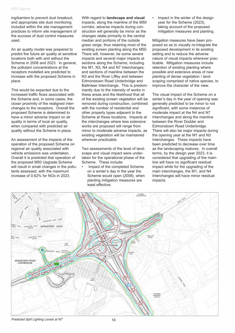
Predicted Spill Lighting Levels at N7

17
M50 Upgrade
An Archaeological, Cultural Heritageand Architectural Heritage assess-ment was undertaken for the construc-tion and operation of the proposedScheme.
Two sites, Archaeological Site16 (areaof potential), Archaeological Site 19(habitation site) will be impacted direct-ly by construction of the Scheme. NoArchitectural Sites will be directlyimpacted. Sixteen river crossings maybe directly impacted during construc-tion of the scheme to varying extentsdepending on the construction method-ology employed.
Following the EIS publication, areas tobe affected by the construction andidentified by the NRA project archaeol-ogist as being relatively undisturbed,were archaeologically tested. Noarchaeological features were identified.
Additional road lighting will be provid-ed as part of the M50 UpgradeScheme to ensure road lighting for theupgraded Scheme meets the roadlighting standards. The potentialimpact of spill lighting from the pro-posed lighting design has beenassessed for the construction andoperation of the Scheme.
The spill lighting assessment indicatedthat average light spill along the main-line of the M50 would be in the order of1.2Lux (on the horizontal plane) at 20mfrom the motorway boundary. This
level is comparable to bright moonlightand considerably lower than the stan-dard for residential street lighting andthe effect is considered to be not significant.
Impacts from spill lighting at the inter-changes were predicted to be not sig-nificant with the exception of two prop-erties, which are predicted to experi-ence minor and moderate impacts.
An assessment of the impacts of theproposed Scheme on community wasundertaken with regard to the guide-lines given in UK Design Manual forRoad and Bridges . Communities aretaken to constitute groups of peopleand the study does not assess theimpact of the Scheme on particularpersons / households/ businesses.
A major part of this assessment con-sidered: (i) changes in journey lengthresulting from physical alterations tothe road and increased traffic volumes,(ii) changes in journey amenity, (iii) theimpact on community/recreationalresources, and (iv) public transport.
The Contractor will be responsible forthe preparation and implementation ofthe Community Liaison Plan during theconstruction phase with the aim of min-imising the impact on the communityas far as practicable.
Existing cyclist and pedestrian accesswill be maintained where feasible, and
temporary alternative routes will beprovided where necessary. Significanttraffic delays, temporary diversions,speed restrictions, lane restrictions andcontra-flows are likely adjacent to con-struction works. The contractor isrequired to liaise with bus operators tominimise the potential disruption toservices. Some bus stops will requirerelocation during construction worksand pedestrian access to these will beprovided.
The upgrade of the N3 interchange willrequire temporary disruption of theDublin-Maynooth/Sligo railway line. Atthe N7, the Luas line will be affected.Any temporary track closures/posses-sions and temporary train/tram speedrestrictions will be agreed in advancewith Iarnród Éireann/RPA and timed tominimise, in so far as is practicable,delays and disruption to railway opera-tions and the travelling public.
The predicted impact of the proposedM50 Upgrade Scheme on privateproperty and material assets to befully or partly acquired by the schemewas assessed. The impact wereassessed in terms of loss ofbuildings/facilities (including planningpermissions), size of land holding, sizeof landtake, proximity to the route, lossof access, viability of the commercial,community or agricultural property andlevel of severance.
A total of nine (9) properties will befully acquired and/or are predicted toexperience a major adverse impactdue to the proposed scheme, consist-ing of six (6) commercial properties,two (2) residential properties and one(1) undeveloped private landholding.These acquisitions will result in a majoradverse impact.
The EIS also considered in some detailthe affect of the scheme on climate,terrestrial ecology, surface waterresources and soils and geology.While a level of protection of theseresources is required during construc-tion, no significant residual effects areanticipated.
Photomontage of Proposed N2

18
M50 Upgrade
Land and Property Issues
A key principle governing the designand construction of the Scheme wasthe minimisation of land take, andtherefore, the impact on the local community. The method of wideningthe mainline will have limited impact onadjacent land. Where land has beenacquired along the mainline this is pre-dominantly required for the installationof walls/barriers and drainage worksincluding emergency spill containmentfacilities. Similarly the design of theinterchanges incorporates the use ofcompact loop geometrical interchangesprimarily to reduce encroachment onsurrounding land.
The acquisition of a total of 20 ha ofprivate land and a further 35 ha ofpublic (local authority and governmentowned) land was required for the con-struction and operation of the M50Upgrade Scheme. Approximately 90residential, commercial, agricultural,community and recreational properties,Local Authority land and Governmentland, were affected by the CompulsoryPurchase Order (CPO). The construction and operation of theM50 Upgrade Scheme requires thepermanent acquisition of one privatedwelling and one local authority owneddwelling.
Oral Hearing
The CPO and EIS for the Schemewere submitted to An Bord Pleanála inlate September 2004. A total of 26 nosubmissions were made regarding theCPO and 226 regarding the EIS. Anumber of these were common to both.
The Board held a public oral hearingfor the scheme over a two week periodin December 2004/January 2005.Representations were made at thehearing by residents associations,landowners, homeowners, public repre-sentative and other interest groups.
Particular attention was focused on thefollowing:
• Land take, disturbance and accommodation works at lands affected by the CPO
• Construction disturbance to local residents
• Strategic transportation issues, including the construction of the upgrade prior to the provision of public transport provision (metro) and demand management measures
• Revision to the N3/M50 interchange to the east, and its interaction with the rail and canal, to improve access arrangements to adjacent lands
The Board gave approval to constructthe scheme, subject to conditions inApril 2005.
Comparison with SchemeObjective
As described earlier, the objective ofthe Scheme is to improve the capacityof the M50 within the context of anintegrated transportation strategy forDublin. The proposed Scheme willdeliver this basic objective and supplyfurther benefits to road users.
• The Scheme will result in an increase in the capacity of the M50 motorway, which will allow all road users including key public transport services, such as buses and taxis as well as commercial vehicles to benefit from significantly reduced traffic congestion. Given the multi-functional role that the M50 will continue to perform, these benefits will be shared by both local transport movements and those serving the strategic locations, such as the Airport and Dublin Port. The DTO Strategy recognises that these benefits of improved accessibility and reduction in congestion, particularly to the port and airport
for passengers and goods, are required to support the regional economy and are also significant in a national and international context.
• The improvements proposed at the interchanges and on the mainline are consistent with providing a more balanced major road hierarchy. They complement, at strategic level, the improvementsto the radial routes outside the M50and other major infrastructure, suchas the Dublin Port Tunnel. At the detailed level the Scheme will provide more efficient access to theM50 itself by reducing congestion on the approach routes and reducing the potential for traffic queues forming on the off ramps reducing the effectiveness of the motorway.
• The Scheme will be beneficial in delivering traffic reductions on a number of local roads in and around the M50 corridor.
• The Scheme will not create conditions which encourage additional commuting to the city centre by car.
• Neither will the Scheme generate any significant levels of induced traffic which have not already been incorporated in the transportation assessment.
• The monetary value of the significant benefits derived from the Scheme is encapsulated in the cost benefit analysis and a robust economic performance.
• To protect the benefits of the Scheme, it will be necessary in the future to implement specific Scheme demand management measures to control the level of traffic growth on the motorway. The precise nature of these measures will be established when the Scheme is operational.
Acknowledgement
The authors wish to acknowledge and thank the members of the M50 Steering Committee and their staff for their guidanceand support during the development of the M50 Upgrade Scheme. They would also like to thank the many members of the
Arup Team for their ongoing commitment to the project and the specialist sub-consultants who provided valuable support throughout.