the us integrated ocean observing system mark e. luther college of marine science university of...
TRANSCRIPT

The US Integrated Ocean Observing System
Mark E. LutherCollege of Marine ScienceUniversity of South Florida
US-GOOS Steering Committee

IOOS: The US Contribution to GOOS1 System, 7 Goals
Locally Relevant – Nationally CoordinatedBenefits Many User Groups
• Improve the safety & efficiency of marine operations
• Improve homeland security
• Mitigate effects of natural hazards more effectively
• Improve predictions of climate change & their effects
• Minimize public health risks
• Protect & restore healthy coastal marine ecosystems more effectively
• Sustain living marine resources

Architecture
NORLC 2
U.S. IOOSThree Scales of Observations
NationalBackbone
Global Ocean Climate Component
GOOS/GCOS Coastal Ocean
GLs NE
MAB
SEGoMex
HIsl
GoA
NW
SW
RegionalObservingSystems
Integrated, Multi-Scale Integrated, End-To End
NORLC 4
Analysis, Modeling
Data Communications & Management
MonitoringIn Situ & Remote Sensing
Groups that Use, Depend on, Manage or Study Oceans & Coasts
IOOS
EndToEnd
Data &Information
AssessImprove

Real-time Obs from GTS Feb 2005
Surface Obs – Drifters, Moorings
Subsurface Obs – XBTs, Argo, Moorings
Global Component of the Observing SubsystemIntegrate Remote & In Situ Sensing
An International Collaboration
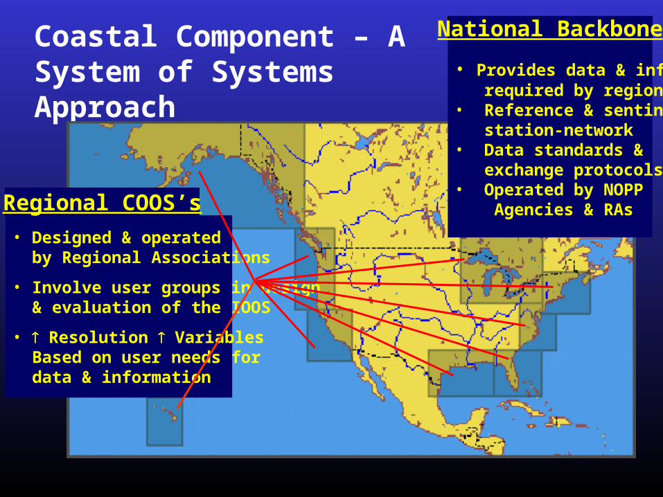
Coastal Component – A System of Systems Approach
• Provides data & info required by regions• Reference & sentinel station-network• Data standards & exchange protocols• Operated by NOPP Agencies & RAs
• Designed & operated by Regional Associations
• Involve user groups in design & evaluation of the IOOS
• Resolution Variables Based on user needs for data & information
Regional COOS’s
National Backbone

Observing Systems in Florida are building blocks of both the Southeast Atlantic Coastal Ocean Observing System (SEACOOS) and the Gulf of Mexico Coastal Ocean Observing System (GCOOS).
SEACOOS and GCOOS are actively partnered with SeaGrant Extension Network to engage private sector collaborators/partners in both regions – see www.seacoos.org and www.gcoos.org
SEACOOS
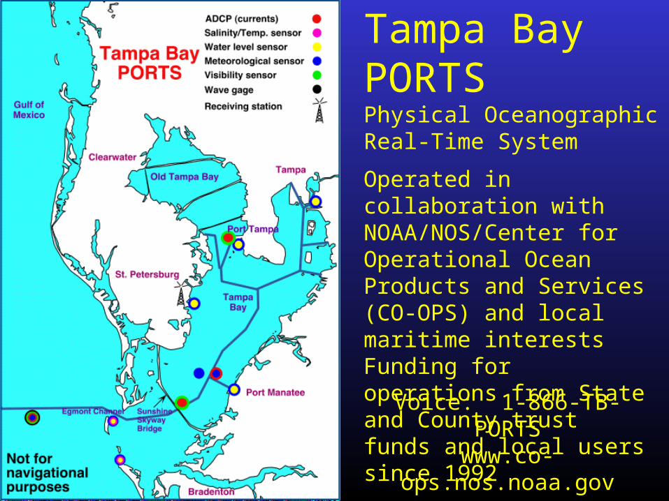
Tampa Bay PORTSPhysical Oceanographic Real-Time System
Operated in collaboration with NOAA/NOS/Center for Operational Ocean Products and Services (CO-OPS) and local maritime interestsFunding for operations from State and County trust funds and local users since 1992
Voice: 1-866-TB-PORTSwww.co-ops.nos.noaa.gov
orompl.marine.usf.edu/PORTS

Winds, Currents, Water Level Updated every 6 min

Pilot Carry-on Units Display Real-Time PORTS Data aboard ships as part of an operational Vessel Traffic Information System (VTIS)
Since PORTS became operational in 1992, ship groundings have decreased by 60%

Real-time observations are combined with a model of currents and water level to provide a predictive capability for storm surge, search and rescue, environmental management, or hazardous material spills
Sewage Spill Trajectory
Desal Plant
+ Hindcast-Nowcast-Forecast model is used for storm surgeprediction and mitigation and for permitting of water supply and other projects

+ Piney Point Phosphate Plant
and to predict transport and fate of discharge from an abandoned phosphate processing facility for Fl. Dept. of Environmental Protection
Sewage Spill Trajectory
Phosphate Discharge Trajectory
Model is used by Pinellas County Department of Health to predict trajectories of accidental sewage spills

West Florida Coastal Ocean Monitoring and Prediction System (COMPS)
Real-time data from offshore buoys, coastal towers, HF radars merged with models and satellite observations
COMPS observations are available thru NDBC
http://comps.marine.usf.edu or http://ndbc.noaa.gov/Maps/Florida.shtml
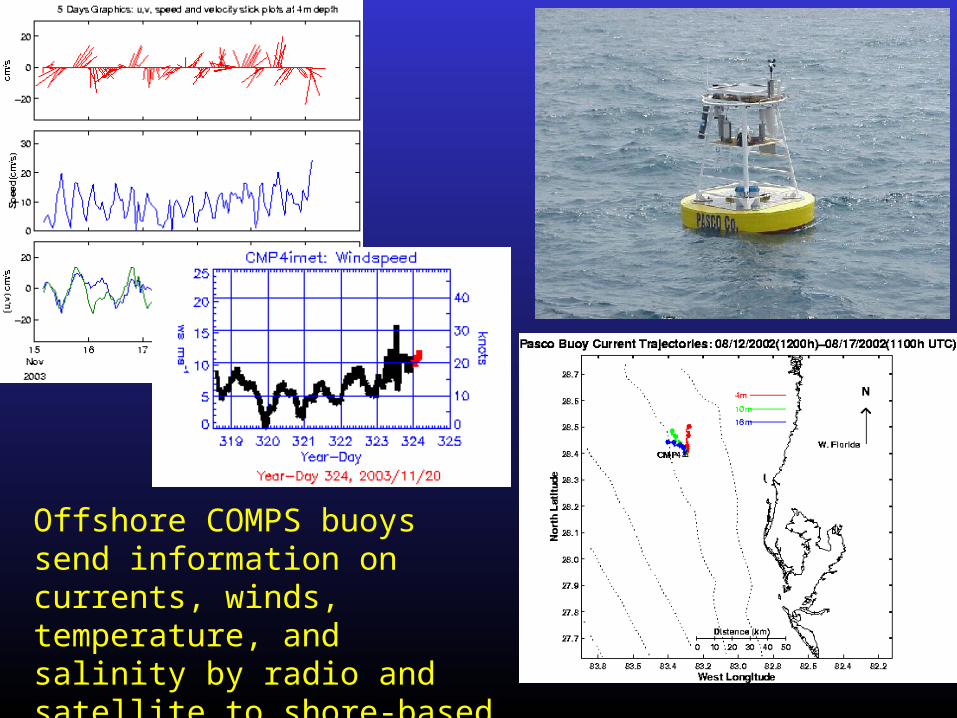
Offshore COMPS buoys send information on currents, winds, temperature, and salinity by radio and satellite to shore-based computers and the Internet

Coastal sites send water levels and other oceanographic and meteorological data by satellite and radio
Shell Point
New Port RicheyCape Sable
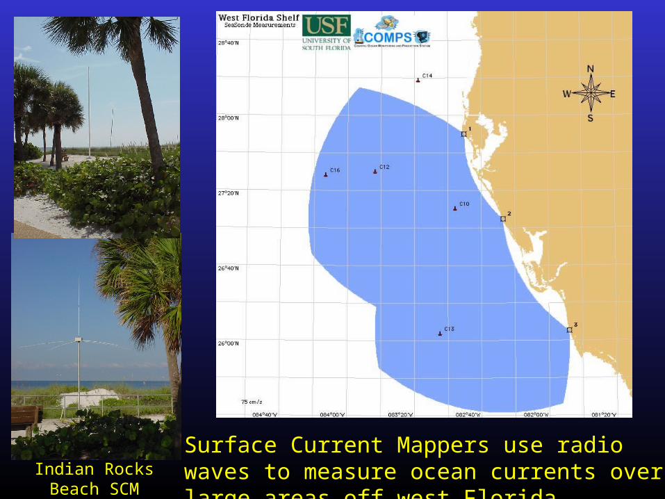
Surface Current Mappers use radio waves to measure ocean currents over large areas off west FloridaIndian Rocks Beach
SCM antennas

Ultimate goal of IOOS is to provide useful products for anyone who makes
decisions in coastal regions of the US - see http://ocean.us

June 29, 2002
June 30, 2002
July 1, 2002
Census 2000
Seabreeze and Power Generation Utilities in Coastal Regions (Rutgers University)
Large increase in summer coastal population Greatest challenge for the NJ power grid Seabreeze modulates power demand Coastal upwelling modulates seabreeze Local generation required to meet demand
NJ Ocean Observing System allows better prediction of seabreeze and large savings for power generation utilitiesOperational monitoring began in 2004

Alliance for Coastal Technologies (ACT)
Coastal Services Center
Gulf of MaineOcean Observing System
Monterey Bay AquariumResearch Institute
Moss Landing Marine Laboratories
University of MichiganCooperative Institute forLimnology & Ecosystems Research
Alaska SeaLife Center University of Alaska
(Joining Soon)
ACT Organization - Headquarters, Partners, Stakeholder Council, Alliance Members
www.act-us.info

US-ACT is collaborating with European colleagues in an effort to form a EuroACT
EuroAct will eventually include partners from each European eco-region
First workshop was held in Lisbon on 1-2 March 2004 and hosted by
EuroAct Partners currently seeking EU funding
EuroACT
ACT Organization - Headquarters, Partners, Stakeholder Council, Alliance Members
QuickTime™ and aTIFF (Uncompressed) decompressor
are needed to see this picture.
Assure common/standardized technologies
Encourage joint opportunities in technology development
Exchange information
www.act-us.info