the vaupes arch and casiquiare canal
TRANSCRIPT
FOURTEEN
The Vaupes Arch and Casiquiare CanalBarriers and Passages
KIRK O. WINEMILLER and STUART C. WILLIS
This chapter examines the relationship between the fi sh fau-nas of the Amazon and Orinoco river basins and distributions of species across the Vaupes Arch region, the major drainage divide in the Llanos region of eastern Colombia and the west-ern limit of the Guiana Shield in Venezuela. Our focus is the differences and similarities in the two faunas and the histori-cal and contemporary geographic and environmental factors that infl uence fi sh distributions, speciation, and adaptation. The subject of this chapter overlaps with several other chap-ters in this volume; consequently, our discussion will be lim-ited to geological events that occurred after the elevation of the Vaupes Arch approximately 8–10 Ma in the region that encompasses the southern extent of the Colombian Llanos and the Atabapo and Casiquiare subbasins in southwestern Venezuela. The rise of the Vaupes Arch separated the ancient paleo-Amazon-Orinoco River into two separate drainages—the Orinoco fl owing to the north then northeast, and the Amazon fl owing to the east once it had breached the Purús Arch. Dis-cussions of earlier geological events and their infl uence on the fi sh fauna of northern South America appear in other chapters within this volume. In particular, Chapter 7 describes the bio-geography of the Neogene, and Chapters 13 and 15 provide detailed descriptions of geological events and their potential infl uence on fi sh distributions in northern South America. These chapters should be consulted for descriptions of events during earlier periods.
The Amazon Basin, the largest in the world, covers about 7 million km2 (about 40% of the area of South America) and has an averaged discharge of nearly 180,000 m3/s. The main-stem Amazon River, which is called the Solimões River in Brazil until its junction with the Negro River near the city of Manaus, is estimated to be about 6,700 km long, with approximately 15,000 tributaries and subtributaries—four of which are over 1,600 km long. The Negro River, the huge north-bank tribu-tary, has a mean discharge estimated at 28,000 m3/s, which is about 15% of the annual discharge of the Amazon, and which ranks it fi fth among rivers worldwide. Other major tributar-
ies include the Purús, Madeira, Tapajós, Xingu, and Tocantins on the south bank, and the Napo, Japurá, and Trombetas on the north bank. The rivers and streams of the Amazon Basin have highly varied water chemistry (Sioli 1984), ranging from extreme black waters of low pH and conductivity (e.g., Negro) to clear waters with high transparency (e.g., Trombe-tas), to white waters with neutral pH and low transparency due to high loads of suspended sediments (Napo). In general, rivers draining the Andes in the western region of the basin are white water, and those draining the Guyana and Brazilian Shields are either clear water or black water. Most of the Amazon Basin lies at very low elevation and is covered in trop-ical forests, with areas of savanna occurring in upland regions of the Guiana Shield to the north and especially within the Brazilian Shield, south of the eastern main stem. The origin of the river is the headwaters of the Ucayali River draining the eastern slope of the Andes in Peru. After the river leaves the Andes on its eastward course toward the Atlantic, it is a broad meandering channel with many islands and side channels and a gradient of only 1.5 cm/km.
The Orinoco Basin covers about 1 million km2 and has a mean annual discharge of approximately 30,000 m3/s, which ranks it third among rivers globally. The main stem of the Ori-noco River is estimated to be about 1,500 km from its delta on the Caribbean coast of northeastern Venezuela to headwaters in the Parima Mountain range on the border of Venezuela and Brazil. The Guaviare River, which originates in the Colombian Andes and fl ows through the Colombian Llanos before joining the Lower Orinoco near the town of San Fernando de Atabapo, Venezuela, has a larger and longer channel than the Upper Orinoco, and also has the same sediment-rich water as the lower Orinoco. The Guaviare River could therefore be consid-ered the real main stem of the Orinoco River. To the east and south, the Orinoco Basin is bordered by mountain ranges of the Guiana Shield (Figure 14.1). To the west, the basin is sepa-rated from the Magdalena and Maracaibo basins by branches of the Andes Mountains, and to the north it is separated from small coastal drainages and the Lake Valencia Basin by coastal mountain ranges. Along much of its course through the Lla-nos of Colombia and Venezuela, the Lower Orinoco and its principal tributaries (e.g., Guaviare, Meta, Apure) have broad, low-gradient braided channels. Above the juncture of the
225
Historical Biogeography of Neotropical Freshwater Fishes, edited by James S. Albert and Roberto E. Reis. Copyright © 2011 by The Regents of the University of California. All rights of reproduction in any form reserved.
c14.indd 225c14.indd 225 4/7/2011 7:21:30 PM4/7/2011 7:21:30 PM
226 REGIONAL ANALYSIS
Guaviare and Atabapo rivers, the Upper Orinoco is a clear-water meandering river. There are two major rapids, one just above the confl uence with the Meta River (Raudales de Atures) and the other just above the confl uence with the Tomo River (Rauales de Maipures). The main channel fl ows northward then northeasterly along the northern margin of the Guiana Shield before forming its delta on the Carib-bean coast near the Island of Trinidad. Much like those of the Amazon, landscapes of the Orinoco Basin are varied, with savannas dominating the northern and western regions, and tropical wet forest dominating the Guiana Shield region in the south and east (M. A. Rodriguez et al. 2007). Major tributaries of the Orinoco entering from the Llanos region are the Gua-viare, Meta, Capanaparo, Arauca, and Apure. All these rivers, except the Capanaparo, carry heavy loads of suspended clays and other highly erodable sediments washed down from the Andes. Tributaries that originate in the ancient weathered landscapes of the Guiana Shield (Ocamo, Padamo, Caura, Caroni) or plains formed by sandy alluvium (Atabapo, Capanaparo) generally have either clear-water or black-water characteristics of low suspended sediments, low conductivity, and low pH.
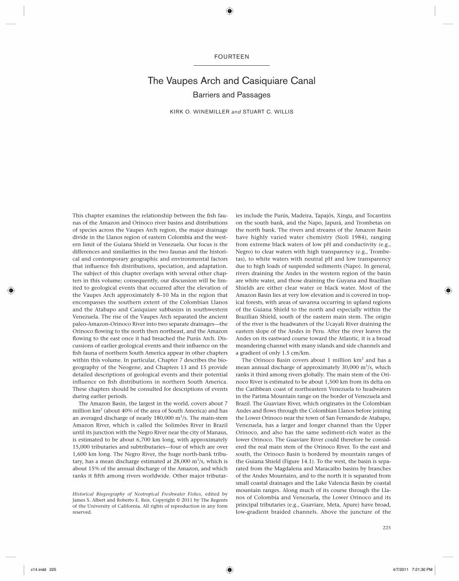
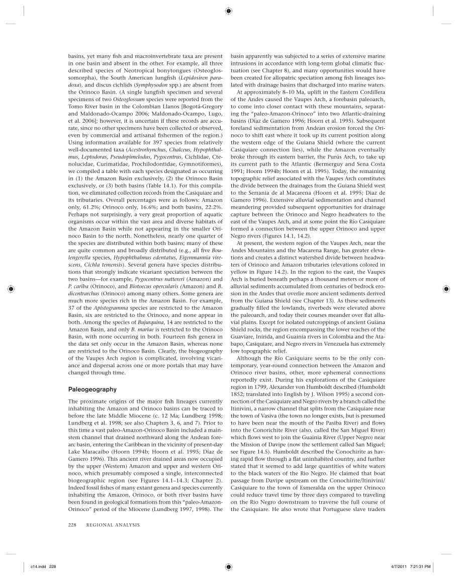
The two basins, Amazon and Orinoco, have a perma-nent fl owing channel connection in southern Venezuela—the Casiquiare River (Figure 14.2). As described in Chap-ter 13, the Casiquiare captures fl ow from the headwaters of the Orinoco and fl ows in a southwesterly direction to join the upper Negro River, the largest Amazon tributary. By all accounts, the Casiquiare is the largest river in the world that joins two river basins via bifurcation. At its origin at the bifurcation of the upper Orinoco (Figure 14.3), the Casiqui-are is about 90 m wide and lies at an elevation of 120 meters above sea level (m-asl). At its mouth at the upper Rio Negro, the Casiquiare is over 500 m wide (Figure 14.4) at an eleva-tion of about 90 m-asl. The hydrogeology and ecology of the Casiquiare are described in the section “Paleogeography” (see also Thornes 1969; Stern 1970; Sternberg 1975; Winemiller, López-Fernández, et al. 2008).
Amazon and Orinoco Fish Faunas
The Amazon and Orinoco river basins contain extraordinarily diverse assemblages of fi shes, crustaceans, and other aquatic organisms, and have long been considered separate biogeo-graphic provinces (Géry 1969; Weitzman and Weitzman 1982; Hubert and Renno 2006). Given the rapid and ever-accelerating pace of description of new Neotropical fi shes (~400 species per decade; Vari and Malabarba 1998), it is impossible to provide an accurate estimate of fi sh species rich-ness for either basin. Based on rates of species descriptions for various higher taxa, Schaefer (1998) projected an eventual total of at least 8,000 fi sh species for all of the Neotropics. The Amazon Basin clearly contains the greatest fi sh richness; a fre-quently cited estimate of described species is 3,000 (Reis et al. 2003b). The current estimate for fi sh species richness for the Orinoco Basin is well over 1,000 species (Lasso, Lew, et al. 2004), but, even if accurate, the number would change on a monthly basis as new species descriptions are published.
Given that no comprehensive and accurate account of fi sh diversity in these large basins is available, our discussion of fi sh zoogeography will rely on three sources of information. One is recent taxonomic/phylogenetic literature that brings several taxonomic groups into sharper focus. The second is an extensive database from fi sh surveys in the region of the Casiquiare and Upper Orinoco basins in southern Venezuela. This latter information and associated specimens are archived in the Museo de Ciencias Naturales in Guanare, Venezuela (MCNG). The MCNG database was used by Winemiller, López-Fernández, and colleagues (2008) to examine the biogeo-graphy of fi shes in the Casiquiare, and that information is summarized in this chapter. The third source of information is recent molecular phylogeographic studies of fi shes in northern South America. This third source of information is particularly useful for reconstructing patterns of geographic differentia-tion, dispersal, and hybridization.
The Casiquiare River should function as major corridor for dispersal of aquatic biota between the Amazon and Orinoco
Vaupes Arch Casiquiare
Rupununi
Guiana Shield ranges
Andean Mt. ranges Orinoco
Amazon
F IG U R E 14.1 Map showing the current river drainages of northern South America and watershed divides separating the Amazon and Orinoco basins: blue lines are watershed divides associated with major mountain ranges; red lines are watershed divides associated with paleoarches of much lower relief. The Casiquiare River unites the Upper Orinoco and Upper Rio Negro across the Vaupes Arch.
c14.indd 226c14.indd 226 4/7/2011 7:21:30 PM4/7/2011 7:21:30 PM

Orinoco Drainage
Casiquiare
0°
2° N
4° N
68° W 66° W70° W72° W
Negro
Orinoco
Amazon Drainage
Atabapo
Guaviare
Inirida
Guainia
Vaupes
Içana
Vichada
Meta
Negro
Orinoco
Ventuari
Caquetá
Japurá
Apaporis
Ocamo
San Miguelv
Siapa
Pasimoni
Casiquiare
Orinoco
bifurcation
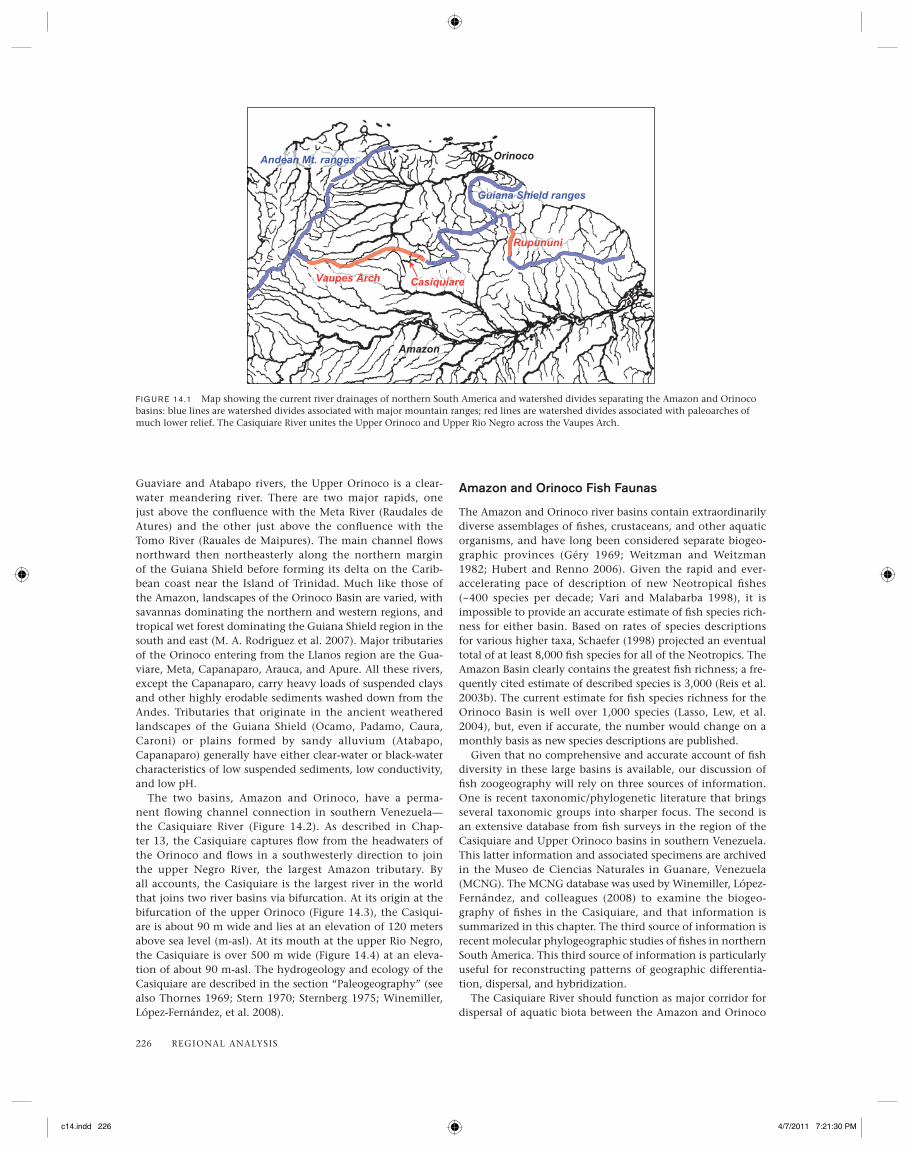
F IG U R E 14.2 Digital elevation map for the region of the Vaupes Arch in southeastern Colombia and southwestern Venezuela. Elevation ranges from 25–50 m-asl (light blue) to 2,500–2,750 m-asl (dark red). Major river courses are overlain as thin black lines. Watershed divides for the Amazon, Orinoco, and Casiquiare basins appear as dotted lines.
F IG U R E 14.3 Aerial photograph of the bifurcation of the Upper Orinoco where the Casiquiare River originates. Image from Google Earth.
Guainia
Negro
Casiquiare
Pasimoni
San Carlos
Caño Tirinquin
F IG U R E 14.4 Aerial photograph of the lower Casiquiare River at its junction with the Guainia-Negro River. The lower reach of the Pasi-moni River, a major black-water tributary, appears in the lower right. Image from Google Earth.
c14.indd 227c14.indd 227 4/7/2011 7:21:30 PM4/7/2011 7:21:30 PM
228 REGIONAL ANALYSIS
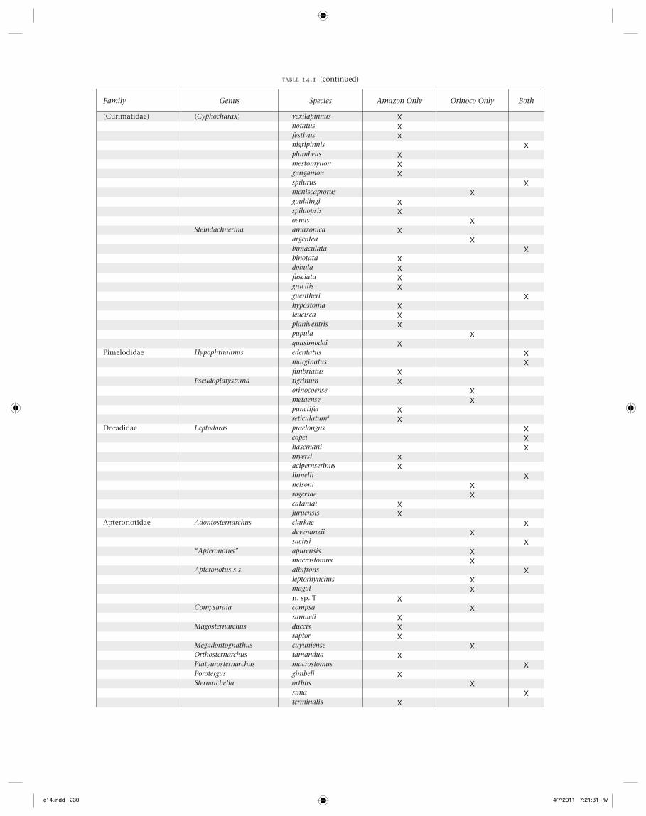
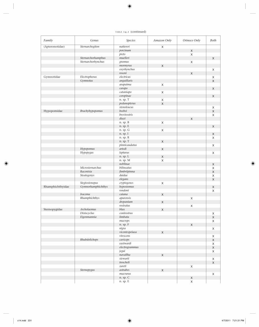
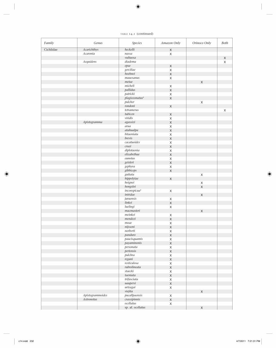
basins, yet many fi sh and macroinvertebrate taxa are present in one basin and absent in the other. For example, all three described species of Neotropical bonytongues (Osteoglos-somorpha), the South American lungfi sh (Lepidosiren para-doxa), and discus cichlids (Symphysodon spp.) are absent from the Orinoco Basin. (A single lungfi sh specimen and several specimens of two Osteoglossum species were reported from the Tomo River basin in the Colombian Llanos [Bogotá-Gregory and Maldonado-Ocampo 2006; Maldonado-Ocampo, Lugo, et al. 2006]; however, it is uncertain if these records are accu-rate, since no other specimens have been collected or observed, even by commercial and artisanal fi shermen of the region.) Using information available for 397 species from relatively well-documented taxa (Acestrorhynchus, Chalceus, Hypophthal-mus, Leptodoras, Pseudopimelodus, Pygocentrus, Cichlidae, Cte-nolucidae, Curimatidae, Prochilodontidae, Gymnotiformes), we compiled a table with each species designated as occurring in (1) the Amazon Basin exclusively, (2) the Orinoco Basin exclusively, or (3) both basins (Table 14.1). For this compila-tion, we eliminated collection records from the Casiquiare and its tributaries. Overall percentages were as follows: Amazon only, 61.2%; Orinoco only, 16.6%; and both basins, 22.2%. Perhaps not surprisingly, a very great proportion of aquatic organisms occur within the vast area and diverse habitats of the Amazon Basin while not appearing in the smaller Ori-noco Basin to the north. Nonetheless, nearly one quarter of the species are distributed within both basins; many of these are quite common and broadly distributed (e.g., all fi ve Bou-lengerella species, Hypophthalmus edentatus, Eigenmannia vire-scens, Cichla temensis). Several genera have species distribu-tions that strongly indicate vicariant speciation between the two basins—for example, Pygocentrus nattereri (Amazon) and P. cariba (Orinoco), and Biotoecus opercularis (Amazon) and B. dicentrarchus (Orinoco) among many others. Some genera are much more species rich in the Amazon Basin. For example, 37 of the Apistogramma species are restricted to the Amazon Basin, six are restricted to the Orinoco, and none appear in both. Among the species of Bujurquina, 14 are restricted to the Amazon Basin, and only B. mariae is restricted to the Orinoco Basin, with none occurring in both. Fourteen fi sh genera in the data set only occur in the Amazon Basin, whereas none are restricted to the Orinoco Basin. Clearly, the biogeography of the Vaupes Arch region is complicated, involving vicari-ance and dispersal across one or more portals that may have changed through time.
Paleogeography
The proximate origins of the major fi sh lineages currently inhabiting the Amazon and Orinoco basins can be traced to before the late Middle Miocene (c. 12 Ma; Lundberg 1998; Lundberg et al. 1998; see also Chapters 3, 6, and 7). Prior to this time a vast paleo-Amazon-Orinoco Basin included a main-stem channel that drained northward along the Andean fore-arc basin, entering the Caribbean in the vicinity of present-day Lake Maracaibo (Hoorn 1994b; Hoorn et al. 1995; Díaz de Gamero 1996). This ancient river drained areas now occupied by the upper (Western) Amazon and upper and western Ori-noco, which presumably composed a single, interconnected biogeographic region (see Figures 14.1–14.3; Chapter 2). Indeed fossil fi shes of many extant genera and species currently inhabiting the Amazon, Orinoco, or both river basins have been found in geological formations from this “paleo-Amazon-Orinoco” period of the Miocene (Lundberg 1997, 1998). The
basin apparently was subjected to a series of extensive marine intrusions in accordance with long-term global climatic fl uc-tuation (see Chapter 8), and many opportunities would have been created for allopatric speciation among fi sh lineages iso-lated with drainage basins that discharged into marine waters.
At approximately 8–10 Ma, uplift in the Eastern Cordillera of the Andes caused the Vaupes Arch, a forebasin paleoarch, to come into closer contact with these mountains, separat-ing the “paleo-Amazon-Orinoco” into two Atlantic-draining basins (Díaz de Gamero 1996; Hoorn et al. 1995). Subsequent foreland sedimentation from Andean erosion forced the Ori-noco to shift east where it took up its current position along the western edge of the Guiana Shield (where the current Casiquiare connection lies), while the Amazon eventually broke through its eastern barrier, the Purús Arch, to take up its current path to the Atlantic (Bermerguy and Sena Costa 1991; Hoorn 1994b; Hoorn et al. 1995). Today, the remaining topographic relief associated with the Vaupes Arch constitutes the divide between the drainages from the Guiana Shield west to the Serrania de al Macarena (Hoorn et al. 1995; Diaz de Gamero 1996). Extensive alluvial sedimentation and channel meandering provided subsequent opportunities for drainage capture between the Orinoco and Negro headwaters to the east of the Vaupes Arch, and at some point the Río Casiquiare formed a connection between the upper Orinoco and upper Negro rivers (Figures 14.1, 14.2).
At present, the western region of the Vaupes Arch, near the Andes Mountains and the Macarena Range, has greater eleva-tions and creates a distinct watershed divide between headwa-ters of Orinoco and Amazon tributaries (elevations colored in yellow in Figure 14.2). In the region to the east, the Vaupes Arch is buried beneath perhaps a thousand meters or more of alluvial sediments accumulated from centuries of bedrock ero-sion in the Andes that overlie more ancient sediments derived from the Guiana Shield (see Chapter 13). As these sediments gradually fi lled the lowlands, riverbeds were elevated above the paleoarch, and today their courses meander over fl at allu-vial plains. Except for isolated outcroppings of ancient Guiana Shield rocks, the region encompassing the lower reaches of the Guaviare, Inirida, and Guainia rivers in Colombia and the Ata-bapo, Casiquiare, and Negro rivers in Venezuela has extremely low topographic relief.
Although the Río Casiquiare seems to be the only con-temporary, year-round connection between the Amazon and Orinoco river basins, other, more ephemeral connections reportedly exist. During his explorations of the Casiquiare region in 1799, Alexander von Humboldt described (Humboldt 1852; translated into English by J. Wilson 1995) a second con-nection of the Casiquiare and Negro rivers by a branch called the Itinivini, a narrow channel that splits from the Casiquiare near the town of Vasiva (the town no longer exists, but is presumed to have been near the mouth of the Pasiba River) and fl ows into the Conorichite River (also, called the San Miguel River) which fl ows west to join the Guainia River (Upper Negro) near the Mission of Davipe (now the settlement called San Miguel; see Figure 14.5). Humboldt described the Conochirite as hav-ing rapid fl ow through a fl at uninhabited country, and further stated that it seemed to add large quantities of white waters to the black waters of the Rio Negro. He claimed that boat passage from Davipe upstream on the Conochirite/Itinivini/Casiquiare to the town of Esmeralda on the upper Orinoco could reduce travel time by three days compared to traveling on the Rio Negro downstream to traverse the full course of the Casiquiare. He also wrote that Portuguese slave traders
c14.indd 228c14.indd 228 4/7/2011 7:21:31 PM4/7/2011 7:21:31 PM
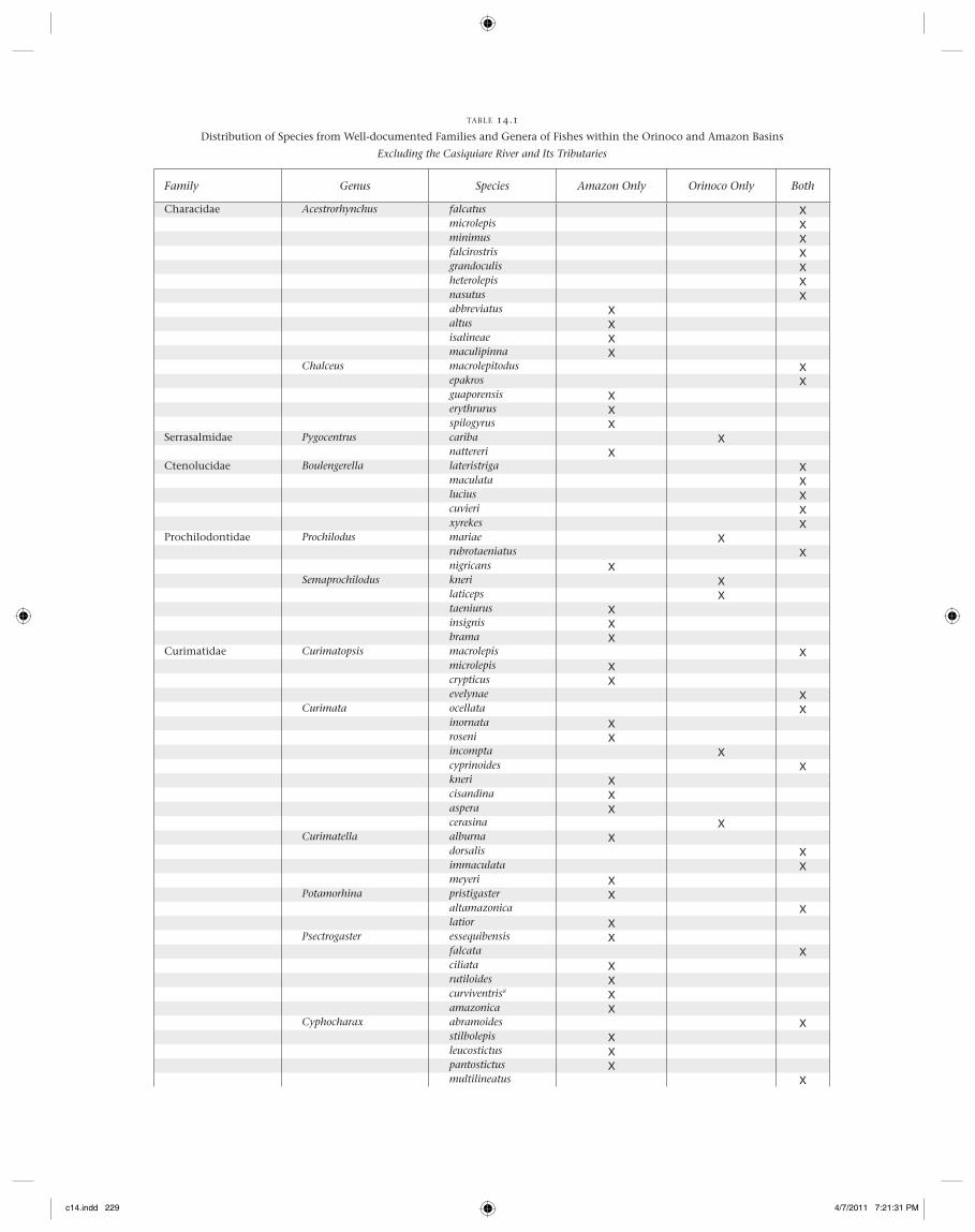
TABLE 14.1
Distribution of Species from Well-documented Families and Genera of Fishes within the Orinoco and Amazon Basins
Excluding the Casiquiare River and Its Tributaries
Family Genus Species Amazon Only Orinoco Only Both
Characidae Acestrorhynchus falcatus Xmicrolepis Xminimus Xfalcirostris Xgrandoculis Xheterolepis Xnasutus Xabbreviatus Xaltus Xisalineae Xmaculipinna X
Chalceus macrolepitodus Xepakros Xguaporensis Xerythrurus Xspilogyrus X
Serrasalmidae Pygocentrus cariba Xnattereri X
Ctenolucidae Boulengerella lateristriga Xmaculata Xlucius Xcuvieri Xxyrekes X
Prochilodontidae Prochilodus mariae Xrubrotaeniatus Xnigricans X
Semaprochilodus kneri Xlaticeps Xtaeniurus Xinsignis Xbrama X
Curimatidae Curimatopsis macrolepis Xmicrolepis Xcrypticus Xevelynae X
Curimata ocellata Xinornata Xroseni Xincompta Xcyprinoides Xkneri Xcisandina Xaspera Xcerasina X
Curimatella alburna Xdorsalis Ximmaculata Xmeyeri X
Potamorhina pristigaster Xaltamazonica Xlatior X
Psectrogaster essequibensis Xfalcata Xciliata Xrutiloides Xcurviventrisa Xamazonica X
Cyphocharax abramoides Xstilbolepis Xleucostictus Xpantostictus Xmultilineatus X
c14.indd 229c14.indd 229 4/7/2011 7:21:31 PM4/7/2011 7:21:31 PM
Family Genus Species Amazon Only Orinoco Only Both
(Curimatidae) (Cyphocharax) vexilapinnus Xnotatus Xfestivus Xnigripinnis Xplumbeus Xmestomyllon Xgangamon Xspilurus Xmeniscaprorus Xgouldingi Xspiluopsis Xoenas X
Steindachnerina amazonica Xargentea Xbimaculata Xbinotata Xdobula Xfasciata Xgracilis Xguentheri Xhypostoma Xleucisca Xplaniventris Xpupula Xquasimodoi X
Pimelodidae Hypophthalmus edentatus Xmarginatus Xfi mbriatus X
Pseudoplatystoma tigrinum Xorinocoense Xmetaense Xpunctifer Xreticulatuma X
Doradidae Leptodoras praelongus Xcopei Xhasemani Xmyersi Xacipernserinus Xlinnelli Xnelsoni Xrogersae Xcataniai Xjuruensis X
Apteronotidae Adontosternarchus clarkae Xdevenanzii Xsachsi X
“Apteronotus” apurensis Xmacrostomus X
Apteronotus s.s. albifrons Xleptorhynchus Xmagoi Xn. sp. T X
Compsaraia compsa Xsamueli X
Magosternarchus duccis Xraptor X
Megadontognathus cuyuniense XOrthosternarchus tamandua XPlatyurosternarchus macrostomus XPorotergus gimbeli XSternarchella orthos X
sima Xterminalis X
TABLE 14.1 (continued)
c14.indd 230c14.indd 230 4/7/2011 7:21:31 PM4/7/2011 7:21:31 PM
Family Genus Species Amazon Only Orinoco Only Both
(Apteronotidae) Sternarchogiton nattereri Xporcinum Xpreto X
Sternarchorhamphus muelleri XSternarchorhynchus gnomus X
mormyrus Xoxyrhynchus Xroseni X
Gymnotidae Electrophorus electricus XGymnotus anguillaris X
arapaima Xcarapo Xcataniapo Xcoropinae Xn. sp. T Xpedanopterus Xstenoleucus X
Hypopomidae Brachyhypopomus beebei Xbrevirostris Xdiazi Xn. sp. B Xn. sp. E Xn. sp. G Xn. sp. I Xn. sp. R Xn. sp. T Xpinnicaudatus X
Hypopomus artedi XHypopygus lepturus X
n. sp. L Xn. sp. M Xneblinae X
Microsternarchus bilineatus XRacenisia fi mbriipinna XSteatogenys duidae X
elegans XStegtostenopus cryptogenes X
Rhamphichthyidae Gymnorhamphichthys hypostomus Xrondoni X
Iracema caiana XRhamphichthys apurensis X
drepanium Xrostratus X
Sternopygidae Archolaemus blax XDistocyclus conirostrus XEigenmannia limbata X
macrops Xn. sp. F Xnigra Xvicentespelaea Xvirescens X
Rhabdolichops caviceps Xeastwardi Xelectrogrammus Xjegui Xnavallha Xstewarti Xtroscheli Xzareti X
Sternopygus astrabes Xmacrurus Xn. sp. C Xn. sp. E X
TABLE 14.1 (continued)
c14.indd 231c14.indd 231 4/7/2011 7:21:31 PM4/7/2011 7:21:31 PM
Family Genus Species Amazon Only Orinoco Only Both
Cichlidae Acarichthys heckelli XAcaronia nassa X
vultuosa XAequidens diadema X
epae Xgerciliae Xhoehnei Xmauesanus Xmetae Xmicheli Xpallidus Xpatricki Xplagiozonatusa Xpulcher Xrondoni Xtetramerus Xtubicen Xviridis X
Apistogramma agassizi Xarua Xatahualpa Xbitaeniata Xbrevis Xcacatuoides Xcruzi Xdiplotaenia Xelizabethae Xeunotus Xgeisleri Xgephyra Xgibbiceps Xguttata Xhippolytae Xhoignei Xhongsloi Xinconspicuaa Xiniridae Xjuruensis Xlinkei Xluelingi Xmacmasteri Xmeinkei Xmendezi Xmoae Xnijsseni Xnorberti Xpanduro Xpaucisquamis Xpayaminonis Xpersonata Xpertensis Xpulchra Xregani Xresticulosa Xrubrolineata Xstaecki Xtaeniata Xtrifasciata Xuaupersi Xurteagai Xviejita X
Apistogrammoides pucallpaensis XAstronotus crassipinnis X
ocellatus Xsp. af. ocellatus X
TABLE 14.1 (continued)
c14.indd 232c14.indd 232 4/7/2011 7:21:31 PM4/7/2011 7:21:31 PM

Family Genus Species Amazon Only Orinoco Only Both
(Cichlidae) Biotodoma cupido Xwavrini X
Biotoecus dicentrarchus Xopercularis X
Bujurquina apoparuana Xcordemadi Xeurhinus Xhophrys Xhuallagae Xlabiosa Xmariae Xmegalospilus Xmoriorum Xortegau Xperegrinabunda Xrobusta Xsyspilus Xtambopatae Xzamorensis X
Caquetaia myersi Xspectabilis Xkraussii X
Chaetobranchopsis australis Xorbicularis X
Chaetobranchus fl avescens Xsemifasciatus X
Cichla orinocensis Xintermedia Xmonoculus Xpleiozona Xjariina Xthyrorus Xpinima Xvazzoleri Xpiquiti Xkelberi Xmelaniae Xmirianae Xtemensis X
Cichlasoma amazonarum Xaraguaiense Xbimaculatum Xboliviense Xorinocense X
Crenicara latruncularium Xpunctulatum X
Crenicichla acutirostris Xadspersa Xalta Xanthurus Xcametana Xcincta Xcompressiceps Xcyanonotus Xcyclostoma Xgeayi Xheckeli Xhemera Xhummelincki Xinpa Xisbrueckeri Xjegui Xjohanna Xlabrina X
TABLE 14.1 (continued)
c14.indd 233c14.indd 233 4/7/2011 7:21:31 PM4/7/2011 7:21:31 PM

Family Genus Species Amazon Only Orinoco Only Both
(Cichlidae) (Crenicichla) lenticulata Xlucius Xlugubris Xsp. af. lugubris Xmacrophthalma Xmacmorata Xnotophthalmus Xpellegrini Xpercna Xphaiospilus Xproteus Xpydanielae Xregani Xreticulata Xrosemariae Xsantosi Xsedentaria Xsemicincta Xstocki Xstrigata Xsveni Xtigrina Xurosema Xvirgulata Xwallacii Xsp. af. wallacii X
Dicrossus fi lamentosus Xmaculatus X
Geophagus abalios Xaltifrons Xargyrostictus Xdicrozoster Xgottwaldi Xgrammepareius Xmegasema Xproximus Xtaeniopareius Xwinemilleri X
Guianacara stergiosi XHeroina isonycterina XHeros efasciatus X
notatus Xseverus Xspurius X
Hoplarchus psittacus XHypselacara coryphaenoides X
temporalis XLaetacara curviceps X
dorsigera Xfl avilabris Xthayeri X
Mesonauta acora Xegregius Xfestivus Xinsignis Xmirifi cus X
Mikrogeophagus altispinosus Xramirezi X
Nannacara adoketa Xtaenia X
Pterophyllum altum Xleopoldi Xscalare X
TABLE 14.1 (continued)
c14.indd 234c14.indd 234 4/7/2011 7:21:32 PM4/7/2011 7:21:32 PM

THE VAUPES ARCH AND CASIQUIARE CANAL 235
Family Genus Species Amazon Only Orinoco Only Both
(Cichlidae) Retroculus lapidifer Xseptentrionalis Xxinguensis X
Satanoperca daemon Xlilith Xacuticeps Xjurupari Xpapaterra Xmapiritensis X
Symphysodon aequifasciatus Xdiscus X
Taeniacara candidi XTahuantinsuyoa chipi X
macantzatza XTeleocichla centisquama X
centrarchus Xcinderella Xgephyrogramma Xmonogramma Xprionogenys Xproselytus X
Uaru amphiacanthoides Xfernandezyepezi X
Total 244 66 88
aOccurrence in the Upper Madeira River likely from dispersal from the Paraguay Basin.
TABLE 14.1 (continued)
working within Spanish territory of the Casiquiare region would, until their activities were halted by the Spanish in 1756, take boats up the Casiquiare to enter the Conochirite via Caño Mee (this name does not appear on any maps examined by the authors), and then dragged their canoes overland to the Rochuelas of Manuteso (this name also is absent from maps) to enter headwaters of the Atabapo. According to detailed drain-age maps, small tributaries of the Conochirite lie within 10 km of tributaries of the Rio Atacavi and Rio Temi tributaries of the Atabapo, and topographic maps reveal that this area has extremely fl at topography.
Humboldt made his initial passage from the Orinoco to the Rio Negro via the Atabapo River. A short overland route called the Isthmus of Pimichin separates headwater tributaries of the Atabapo and Guainia rivers. Humboldt ascended the Temi branch of the Atabapo to the Mission at Yavita, had his boats dragged across the isthmus over a distance of about 15 km in a fl at landscape containing marshes, and descended down the Pimichin Creek to the mission at Maroa on the Guainia. Explorers before and after Humboldt have used this same route (Rice 1921; Maguire 1955).
Once Andean foreland sedimentation had fi lled in the low-land valleys on either side of the divide in the eastern region of Vaupes Arch, multiple interbasin surface connections could have been formed and destroyed as stream courses eroded and meandered across the fl at terrain. These dispersal avenues apparently were fairly recent, beginning well after the rise of the Vaupes Arch created the Orinoco-Amazon divide, and resulting in allopatric speciation within numerous aquatic taxa. Careful examination of digital elevation maps reveals low areas that conform to contemporary waterways charted on maps, but other low areas seem to be associated with water-courses that either are not permanent or might correspond
to landscape remnants of past drainage patterns. Figure 14.5 shows a digital elevation map of the Casiquiare region overlaid with hypothesized watercourses based on the network of min-imum topographic relief. This network suggests past or per-haps present and ephemeral connection between the Guainia River near Maroa and the Temi (Atabapo) River near Yavita. It also suggests a watercourse along the route described by Humboldt—from the Casiquiare near the Pasiba mouth (Lago Pasiba) through a channel (presumably Humboldt’s Itinivini) to the San Miguel (Conochirite) and Rio Guainia. Signifi cantly, the digital elevation map does not reveal the watercourse of the upper Casiquiare from its origin at the upper Orinoco bifurca-tion to near the Pasiba mouth. This suggests that the upper Casiquiare course may have been captured quite recently by the Pasiba–Siapa–lower Casiquiare drainage network as a result of river meandering on the peneplain.
During the early 1900s, Hamilton Rice made extensive geo-graphic explorations of river courses in the region of the Upper Rio Negro, Colombian Llanos, and Casiquiare for the Royal Geographic Society (Rice 1914, 1921). His detailed maps show very close proximities of headwater streams of several adjacent river drainages. The close proximity of the Pimichin Creek (Guainia tributary) with the Temi (upper Atabapo) as described by Humboldt was confi rmed by Rice (1914). One of his maps also shows an overland trail of approximately 10 km between a creek draining into the upper Guainia and the Guacamayo Creek (2°21′25″ N, 69°33′1″ W) that drains into the Inirida River (Orinoco Basin). This region of the Colombian Llanos encompasses very fl at, forested terrain with seasonal fl ooding. The Raudal Alto rapids are located on the Inirida River several kilometers downstream from the mouth of Guacamayo Creek. One of Rice’s maps also shows the headwaters of the Rio Içana (Negro tributary) almost in contact with the headwaters of the
c14.indd 235c14.indd 235 4/7/2011 7:21:32 PM4/7/2011 7:21:32 PM

236 REGIONAL ANALYSIS
Papunáua River (Inirida tributary) in a region that is fl at and heavily forested (1°53′37″ N, 70°8′53″ W). Of biological sig-nifi cance is the observation that every one of these headwater creeks positioned on opposite sides of the Orinoco-Amazon interbasin divide is a tributary of an acidic black-water river (Inirida, Atabapo, Guainia, Içana).
Contemporary Habitats and Species Distribution Patterns
Numerous and variable rivers drain the highly heterogeneous landscapes of the upper Orinoco–Casiquiare–upper Negro region. The region’s streams range considerably in color, sedi-ment load, and physical and chemical parameters—properties that are strongly infl uenced by the geology, vegetation cover, and climatic regimes of local watersheds (Sioli 1984; Huber 1995). Traversing this diverse landscape, the Casiquiare River links watersheds with markedly different physicochemical characteristics. The upper Orinoco Basin contains mostly clear-water streams with relatively high transparency, slightly acid pH, moderate concentration of dissolved organic and inorganic substances, and clay-bearing sediments (Weibezahn et al. 1990). The major rivers of the region (Padamo, Ocamo, Mavaca, Orinoco headwaters) sometimes assume mild white-water conditions of suspended particulate matter that reduces transparency. In contrast, streams of the upper Rio Negro
Basin have black waters with low concentrations of suspended particles and negligible solutes, stained by tannins and other organic compounds leached from vegetation, with extremely low pH (as low as 3.5) and fl owing over substrates of fi ne quartz sand (Sioli 1984; Goulding et al. 1988).
The Casiquiare and its many tributaries form a mosaic of dif-ferent water types (Table 14.2). Over its course, the Casiquiare main channel exhibits a marked hydrogeochemical gradient that spans clear to white waters near its origin at the Orinoco bifurcation, to black waters within its lower reaches. The major black-water tributaries contributing waters that shift the physi-cochemistry of the main-stem Casiquiare are the Pasiba and the Pasimoni (Table 14.2), but numerous black-water creeks also contribute to the transition to black water along the lower course. As a result of this gradient in water type, it has been hypothesized that the Casiquiare infl uences the movement of aquatic organisms between the Orinoco and Amazon basins (Mago-Leccia 1971; Goulding et al. 1988; Winemiller et al. 2008). Winemiller, López-Fernández, and colleagues (2008) analyzed fi sh species occurrence and environmental data from surveys performed throughout the Casiquiare Basin includ-ing the upper Negro and upper Orinoco rivers. Their survey of 269 sites encompassed the entire reach of the Casiquiare watercourse and multiple sites within its tributary streams, as well as sites outside the Casiquiare drainage, within the upper Orinoco and upper Negro river systems. They documented 452
2°N
0°
Guainia
Negro
Temi (Atabapo)
Negro
San Miguel
Pasimoni
Siapa
Pasiba
68°W 66°W
Içana
Vaupes
San Carlos
Maroa
YavitaPimichin Isthmus
Itiniviniorigin
São Gabriel
Itinivini
F IG U R E 14.5 Digital elevation map for the Casiquiare region of southeastern Venezuela. The lowest elevations (areas of lightest blue indicating 10–25 m-asl) suggest that there could have been an ancient drainage network (solid black lines) whereby waters of the Siapa and Pasiba rivers fl owed north via the Itinivini channel (area within dotted rectangle) to the San Miguel and Guainia-Negro rivers. The area of low elevation between the Guainia and Atabapo rivers suggests a former channel joining the two rivers, and this area (Pimichin Isthmus within dotted rect-angle) may provide fi shes with a wet-season dispersal route even today. In this hypothetical scenario, the Casiquiare channel has not yet joined the lower courses of the Pasiba and Siapa rivers with the lower course of the Pasimoni, nor has the upper Casiquiare joined the upper Orinoco with rivers draining into the Guainia-Negro and Atabapo rivers. The dotted line represents the course of the present-day Casiquiare.
c14.indd 236c14.indd 236 4/7/2011 7:21:32 PM4/7/2011 7:21:32 PM

THE VAUPES ARCH AND CASIQUIARE CANAL 237
TABLE 14.2
Classifi cation of Rivers in the Casiquiare Region
River Classifi cationpH Range
(number of sites)Secchi Depth Range
(m) (number of sites)
Negro Black 4.7–5.0 (6) 0.8–1.0 (5)Guainía Black 4.1–4.4 (2) —Baría Black 4.2–4.3 (3) 1.2–2.5 (2)Yatúa Black 4.3 (2) 1.5 (1)Pasimoni Black 4.0–4.4 (9) 2.0 (5)Pasiba Black 5.5 —Siapa Black/Clear 4.4–6.5 (9) 1.4 (5)Casiquiare Black/Clear 4.1–6.2 (48) 0.4–2.0 (30)Middle Orinoco Clear 5.1–6.4 (9) 0.5–0.8 (6)Atabapo Black 4.0–5.0 (5) 1.6 (2)Caño Moyo Black 3.8–5.4 (4) 1.1–1.7 (4)Ventuari Black/Clear 5.1–5.3 (3) 1.0–1.1 (3)Upper Orinoco Clear 5.0–7.0 (4) 0.9 (2)Ocamo Clear 6.5–7.0 (9) 0.6–1.0 (4)Padamo Clear 6.0–6.5 (2) 0.9–1.0 (2)Mavaca Clear 5.5–6.5 (13) 0.3–0.9 (5)
NOTE: Based on pH and transparency (Secchi depth) values reported by Weibezahn et al. (1989), Royero Leon et al. (1992), Lasso et al. (2006), and Winemiller, López-Fernández, et al. (2008).
fish species among a wide range of habitat types. The dominant environmental axis contrasted species assemblages and sites associated with clear-water conditions of the upper Orinoco and upper Casiquiare versus black-water conditions of the lower Casiquiare and upper Negro. They proposed that the Casiquiare constitutes a strong environmental fi lter between clear waters at its origin and black waters at its mouth that presents a semipermeable barrier restricting dispersal and faunal exchanges between the fi sh faunas of the upper Orinoco and upper Negro rivers. Some of the fi sh species in their database were limited to black-water habitats of the Negro and lower Casiquiare, Pasimoni, and Pasiba rivers, whereas others were limited in distribution to clear waters of the upper Casiquiare, Siapa, Pamoni, and upper Orinoco rivers.
The strong physicochemical gradient of the Casiquiare River is not the only barrier to fi sh migration between the Orinoco and Amazon basins. Several barriers on either side of the Casiquiare potentially could diminish the importance of the Casiquiare as a dispersal corridor—most notable are the Atures and Maipures rapids on the Orinoco near Puerto Aya-cucho, Venezuela, and the rapids on the Negro River at São Gabriel, Brazil. For some aquatic organisms, these rapids may pose a more severe physical barrier to interbasin dispersal than does the physicochemical gradient of the Casiquiare River. For example, the South American freshwater dolphin is sub-divided into three subspecies, Inia geoffrensis humboldtiana in the Orinoco Basin below the Atures and Maipures rapids, I. g. geoffrensis throughout the Amazon Basin (except for the upper Madeira) and ranging throughout the Casiquiare and upper Orinoco to just above the Atures and Maipures rapids, and I. g. boliviensis restricted to the upper Madeira above the large rapids at Porto Velho (V. Silva 2002).
Fish lineages that evolved endemically within one of these basins may have dispersed to enrich the fauna of the other basin. In the absence of interbasin dispersal, divergence of lineages between the two basins should date no later than to the period of drainage separation, inferred to have been 8–10 Ma. Thus we pose the question: did the Casiquiare or other
connections act as dispersal corridors for the exchange of fi sh lineages between the Amazon and Orinoco basins?
EVIDENCE FROM SPECIES DISTRIBUTION PATTERNS
We reexamined the MCNG Casiquiare database, which included revised taxonomy, especially for catfi shes, and several new collection records from the Casiquiare region that were not available for analysis by Winemiller, López-Fernández, and colleagues (2008). The new database brings the total num-ber of fi sh species in the region to 545. We tabulated species according to the following categories: (1) only recorded from black-water habitats within the Rio Negro and lower Casi-quiare drainage, (2) only recorded from clear-water habitats within the upper Orinoco and upper Casiquiare, (3) recorded on both sides of the divide, with the “divide zone” defi ned as the middle reaches of the Casiquiare (from the mouth of the Pasimoni upstream to the mouth of the Pasiba) plus the entire Siapa River drainage, which is a mosaic of both water types and includes habitats with intermediate water types, and (4) only recorded from within the divide zone. We eliminated any species that did not occur within two or more river subba-sins (subbasins were the same as those reported in Winemiller, López-Fernández, et al. 2008). The results were as follows:
157 (38.1%) species restricted to black-water habitats of the Negro–lower Casiquiare
117 (28.4%) species restricted to clear-water habitats of the upper Orinoco–upper Casiquiare
132 (32.0%) species recorded from both sides of the divide zone
6 (1.5%) species recorded only from within the divide zone
Thus it appears that roughly one-third of the fi sh species are distributed across both water types, a little more than a third are restricted to the black-water conditions of the Rio Negro and lower Casiquiare, and a little less than a third are
c14.indd 237c14.indd 237 4/7/2011 7:21:34 PM4/7/2011 7:21:34 PM

238 REGIONAL ANALYSIS
restricted to the clear-water conditions of the upper Orinoco and upper Casiquiare. The few species restricted to the divide zone were mostly upland-adapted forms collected from sites in the Siapa drainage (Rivulus n. sp., Rhamdia sp.) or rare species. This analysis supports Winemiller, López-Fernández, and colleagues’ (2008) conclusion that the Casiquiare environ-mental gradient functions as a zoogeographic fi lter that per-mits those species capable of dealing, either physiologically or ecologically, with a range of environmental conditions to dis-perse across the waterway and invade a new river basin. Other species appear to lack this tolerance, and remain restricted in distribution despite the existence of a major, perennial surface-water connection between the two basins.
Next, we expanded the MCNG Casiquiare database to include extensive fish collection records for sites in the Atabapo, Ventuari, and Orinoco rivers downstream from the Casiquiare bifurcation to Puerto Ayacucho. This expanded geographic coverage quickly revealed that almost all the black-water-restricted fi sh species from the Rio Negro and lower Casiquiare are present in the Atabapo and Ventuari rivers and black-water creeks entering the Orinoco in the reach between San Fernando de Atabapo and Puerto Ayacucho. Objectively, one cannot rule out the possibility that some of these black-water species dispersed across the full course of the Casiquiare, perhaps as a series of discrete dispersal events over geological time. However, if one accepts that the Casiquiare environmen-tal gradient is a dispersal barrier for many black-water fi shes, this pattern strongly indicates that an alternative dispersal corridor existed (or might still exist) between the black waters of the Guainia and Atabapo rivers. Alternatively, these spe-cies could have dispersed between the basins across a different black-water connection, such as the Inirida-Guainia headwa-ters. It is notable that at least two cichlid species, Uaru fernan-dezyepezi and Geophagus gottwaldi, appear to be restricted to the Atabapo River. Clearly, the capacity or opportunities for interbasin dispersal is not equal for fi shes adapted to different environmental conditions (i.e., black waters).
We further examined the distribution of species across the Vaupes Arch region of eastern Colombia and western Venezu-ela by compiling distribution records in the MCNG and litera-ture sources for the Cichlidae, a group that has been studied extensively (Table 14.3). Only Amazonian cichlids with dis-tributions in the Rio Negro subbasin were included; many additional Amazonian species are restricted to other parts of the basin. We summarized the information from Table 14.3 according to distributions restricted to one or the other basin, or distribution within both. For this analysis we included col-lections from anywhere within the Casiquiare subbasin as neutral; that is, a species having a Negro-restricted distribu-tion could include the Casiquiare, and another species with an Orinoco-restricted distribution could include the Casiquiare. Thirty-four cichlid species (40.5%) are restricted to the Negro/Amazon Basin. Twenty-seven cichlid species (32.1%) are restricted to the Orinoco Basin, and 23 cichlid species (27.4%) occur in both basins. The large number of Amazon/Negro endemics is partially a reflection of the restricted distributions of the numerous dwarf cichlids (Apistogramma species) that tend to inhabit small forest streams in the head-waters of drainages. Nonetheless, it appears that dispersal of cichlid fi shes between drainage systems is a selective process, with about a quarter of all species occurring in both basins. Most of the species that occur in both basins would be con-sidered black-water-adapted forms, thereby lending further support for the hypothesis of a historic (and perhaps contem-
porary) dispersal route via black waters connecting the Atabapo or Inirida rivers with the Guainia River, rather than via the Casiquiare river.
EVIDENCE OF DISPERSAL FROM PHYLOGEOGRAPHY
The geographic distribution of a single species or of two closely related species, in both the Amazon and Orinoco basins, pro-vides an opportunity to investigate biogeography at the pop-ulation level using molecular data. The absence of the same or closely related species in both basins suggests either that dispersal never took place, or that if dispersal did occur, colo-nization was unsuccessful. A less parsimonious explanation, but one that cannot completely be discounted, would be that although dispersal and establishment did take place, the population in one or both basins later went extinct. Molecu-lar markers have the potential to provide tremendous insight into the historical biogeography of freshwater fi shes (Lovejoy, Willis, et al. 2010). Molecular markers provide large amounts of data for phylogenetic analysis, and multiple markers are available for most taxa and temporal and spatial scales of analysis (e.g., Hassan et al. 2003). With a temporally explicit species phylogeny, calibrated either through the use of an external mutation rate or using fossils or ages of geological fea-tures, estimated dates of divergences between contemporary and ancestral species can be used to test biogeographic models. Using a population-genetic approach known as the coalescent that models the process of lineage sorting probabilistically back through time (Kingman 1982), dates of dispersal and population divergence within and among contemporary spe-cies can be estimated even when haplotype lineages at a locus are not reciprocally monophyletic (e.g., Knowles and Carstens 2007). Molecular markers also allow for an estimation of gene fl ow between populations, as well as aiding in the identifi ca-tion of cryptic species.
In order to be useful to address our hypothesis of postvi-cariance dispersal between the Amazon and Orinoco basins, a molecular study must satisfy two criteria: (1) the study must examine the phylogeography (DNA lineages in a geographi-cal context) of populations within a single (or several closely related) species present in both basins, and (2) the study must analyze suffi cient samples (collecting sites and numbers of individuals per site) to provide an estimate of population con-nectivity between the basins. In accordance with these criteria, we decline to discuss several molecular studies that involved potentially vicariant Amazon and Orinoco fi sh species (e.g., Montoya-Burgos 2003; Hubert et al. 2006).
In a study of freshwater needlefi shes of the genera Potamor-rhaphis and Belonion (Belonidae), Lovejoy and Araújo (2000) investigated the geographic distribution of mitochondrial DNA (mtDNA) lineages in the Amazon, Orinoco, and upper Paraguay rivers. They found that the most basal lineages of Potamorrhaphis, inferred to correspond to P. petersi, were dis-tributed in the upper Orinoco River. This species is also alleg-edly distributed in the upper Negro River (above São Gabriel), but Lovejoy and Araújo (2000) were unable to obtain samples for their study; if additional sampling in that region proved to be closely related lineages of P. petersi, it would provide support for limited dispersal between the drainages. How-ever, more derived and closely related mtDNA lineages of this genus, inferred to correspond to the widely distributed P. guia-nensis, were found to be disjunctly distributed in the middle and lower Amazon River and lower Orinoco River, but not in the upper Orinoco or upper Negro.
c14.indd 238c14.indd 238 4/7/2011 7:21:34 PM4/7/2011 7:21:34 PM

TABLE 14.3
Distributions of 85 Cichlid Species within the Orinoco, Negro/Amazon, and Casiquiare Rivers
Species restricted to the Orinoco-Casiquiare Basin have cells shaded in light gray; species restricted to the Negro/Amazon/Casiquiare Basin have cells shaded in dark gray
Documented, X; likely, ?
Genus/Species
Orinoco Casiquiare Negro/Amazon
Middle-lower Orinoco
Upper Orinoco Inirida Atabapo Vaupés
Upper Negro
Middle-lower Negro
Acarichthys heckelii X XAcaronia vultuosa X X X XAcaronia nassaAequidens chimantanus XAequidens diadema X X X ? X ? XAequidens metae XAequidens pallidus XAequidens tetramerus X X X ? X ? XApistogramma brevis XApistogramma diplotaenia X XApistogramma elizabethae XApistogramma gephyra XApistogramma gibbiceps XApistogramma hippolytae XApistogramma hoignei XApistogramma hongsloi XApistogramma iniridae X X ? X ? XApistogramma macmasteri XApistogramma meinkeni XApistogramma mendezi X XApistogramma paucisquamis ? XApistogramma personata XApistogramma pertensis XApistogramma regain XApistogramma uaupesi X XApistogramma viejita XBiotodoma wavrini X X X X X X XBiotoecus dicentrarchus X X X X ? XBiotoecus opercularis XBujurquina mariae XChaetobranchus fl avescens XCichla intermedia X X X ? XCichla monoculus X X ? X X XCichla orinocensis X X X X X ? XCichla temensis X X X ? X ? ?Cichlasoma orinocense XCichlasoma bimaculatum XCrenicichla alta XCrenicichla geayi XCrenicichla johana X ?Crenicichla lenticulata X X ? X ? X XCrenicichla lugubris XCrenicichla af. lugubris X X X X ? XCrenicichla n. sp. Atabapo X X X X ? XCrenicichla macrophthalma ? XCrenicichla notophthalmus XCrenicichla af. wallacii X X X X ? XCrenicichla sveni XCrenicichla virgatula XCrenicichla n. sp. Ventuari X ?Dicrossus fi lamentosus X X ? X ? XGeophagus taeniopareius X XGeophagus gottwaldi XGeophagus abalios X ? ? XGeophagus dicrozoster X ? ? XGeophagus grammepareius XGeophagus winemilleri X X ? X ? XGeophagus n. sp. Negro ? X
c14.indd 239c14.indd 239 4/7/2011 7:21:34 PM4/7/2011 7:21:34 PM

240 REGIONAL ANALYSIS
To explain this distribution, these authors hypothesized a historical connection between the Essequibo and Orinoco riv-ers that acted in concert with a Branco (Amazon)–Essequibo connection (such as the contemporary seasonal connection through the Rupununi savanna; Lowe-McConnell 1964) to allow dispersal between the Amazon and Orinoco basins (see Chapter 13). Although unavailable at the time of that study, samples of Potamorrhaphis from the Essequibo have supported this interpretation (N. Lovejoy, unpublished data). As for Belonion, Lovejoy and Araújo (2000) found a relatively deep divergence between samples from the Orinoco and Negro (Amazon) rivers, corresponding to B. dibranchodon and B. apodion, respectively. These results suggest that the Casiqui-are does not facilitate free exchange of individuals and genes between the Orinoco and Amazonas basins, except perhaps for populations in close proximity within Orinoco and Negro headwater rivers.
In a molecular systematic study of characiforms of the genus Prochilodus, Sivasundar and colleagues (2001) examined the relationships of haplotypes from the mtDNA loci ATPase 8,6 and control region (d-loop) in the Magdalena (trans-Andean), Orinoco, Amazon, and Paraná-Paraguay-Uruguay basins. They found that haplotypes in the Paraná and Amazon basins formed sister clades (P. lineatus and P. nigricans, respectively), with haplotypes from the middle Orinoco (P. mariae) sister to those two, and fi nally haplotypes from the Magdalena (P. magdalenae) as the most basal lineage. Sivasundar and col-leagues (2001) interpreted the divergence between Amazon + Paraná and Orinoco lineages to approximate the “Amazon-Orinoco vicariance” event; however, the estimated date for the
divergence of P. mariae, using the separation of the Magdalena taxon as a calibration point (crudely approximated at ~10 Ma), was 3.9–5.2 Ma, which differs from the date of 8–10 Ma esti-mated for the rise of the Vaupes Arch (Hoorn 1993; Hoorn et al. 1995). In addition, samples were not obtained in this study from the region between Manaus, at the mouth of the Negro, and the middle Orinoco, precluding an examination of ongoing gene fl ow through the Casiquiare region. Indeed, more recent samples from the Casiquiare region appear to belong to both clades (P. cf. mariae and P. cf. nigricans) (G. Orti, unpublished).
In another study of Prochilodus, Turner and colleagues (2004) used sequences of the mtDNA ND4 gene to examine relationships of individuals of P. mariae from the Orinoco, P. cf. rubrotaeniatus from the upper Negro River (near the Casiquiare), Essequibo River, and Caroni River (an eastern Orinoco tributary), and P. magdalenae from the Magdalena River. These authors found that the haplotypes from nominal P. mariae from the upper and middle Orinoco localities were sister to a clade of haplotypes from P. cf. rubrotaeniatus from the Caroni River in the Orinoco. Together, this clade (Orinoco + Caroni) was sister to a clade of (P. cf. rubrotaeniatus) haplo-types from the Essequibo and upper Negro rivers, and fi nally the P. magdalenae haplotypes formed a basal lineage. The date for divergence of the Orinoco and Essequibo + Negro haplo-types was estimated at 3 Ma, also much younger than the pro-posed Amazon-Orinoco vicariance event associated with the rise of the Vaupes Arch. However, given that closely related haplotypes were not found to be shared between the Orinoco and Negro, these authors inferred support for a historical
Genus/Species
Orinoco Casiquiare Negro/Amazon
Middle-lower Orinoco
Upper Orinoco Inirida Atabapo Vaupés
Upper Negro
Middle-lower Negro
Geophagus n. sp. Venuari XGuianacara stergiosi XGuianacara n. sp. Jauaperi XHeros notatus ? XHeros severus X X ? X ? XHeros n. sp. Orinoco X X X ? X ? ?Hoplarchus psittacus X X X X X ? XHypselecara coryphaenoides X X X X X ? XLaetacara fulvipinnis X X ? X ? XLaetacara thayeri XMesonauta insignis X X X X X ? XMesonauta egregious XMesonauta guyanae XMikrogeophagus ramirezi XNannacara adoketa XPterophyllum altum X X X X ? XSatanoperca daemon X X X X X ? XSatanoperca acuticeps XSatanoperca jurupari XSatanoperca n. sp. Casiquiare X X ? X ? XSatanoperca lilith ? XSatanoperca mapiritensis XSymphysodon aequifasciatus XSymphysodon discus XTaeniacara candidi XUaru amphiacanthoides XUaru frenandezyepezi X
TABLE 14.3 (continued)
c14.indd 240c14.indd 240 4/7/2011 7:21:34 PM4/7/2011 7:21:34 PM
THE VAUPES ARCH AND CASIQUIARE CANAL 241
connection between the Orinoco and Essequibo, as hypoth-esized by Lovejoy and Araújo (2000), to facilitate colonization of the Orinoco by Essequibo fi shes. Both of these Prochilodus studies suggest that the Casiquiare is not important as a dis-persal corridor for these taxa, even though lineages within the Orinoco and Amazon basins appear to share common ances-tors more recently than 8 Ma. Additional unpublished molecu-lar data could indicate that P. nigricans in the Amazon and P. rubrotaeniatus in the Negro and Essequibo rivers are conspecifi c (G. Orti, unpublished). In addition, if P. cf. rubrotaeniatus from the Caroni turns out to be more closely related to P. mariae from a study of other genes, the tree from Turner and col-leagues (2004) would become identical to that of Sivasundar and colleagues (2001) except for one missing taxon (P. linea-tus). These studies highlight the need for multilocus molecular analysis of species boundaries in Neotropical fi shes, especially as a prerequisite for testing biogeographic and other evolution-ary hypotheses.
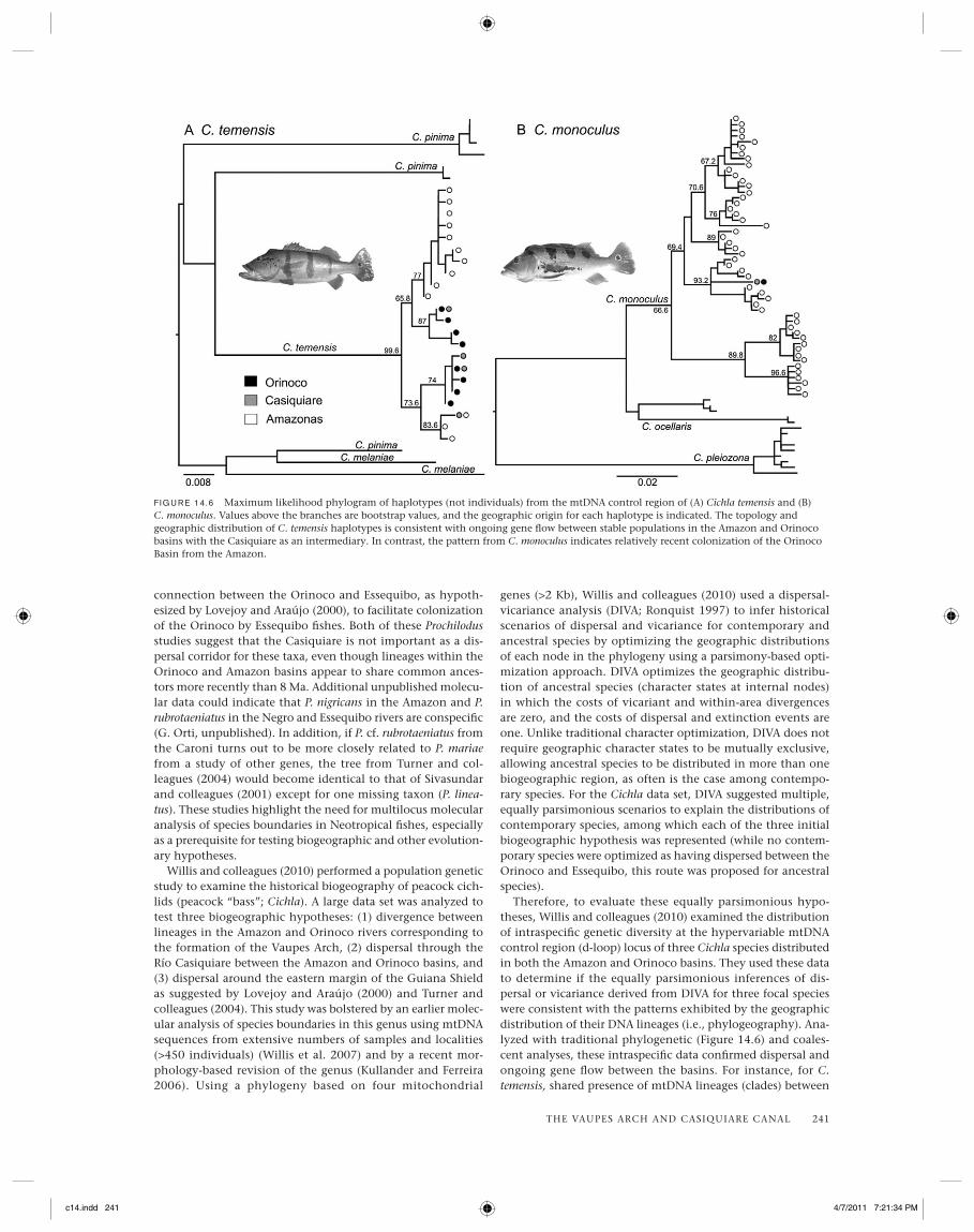
Willis and colleagues (2010) performed a population genetic study to examine the historical biogeography of peacock cich-lids (peacock “bass”; Cichla). A large data set was analyzed to test three biogeographic hypotheses: (1) divergence between lineages in the Amazon and Orinoco rivers corresponding to the formation of the Vaupes Arch, (2) dispersal through the Río Casiquiare between the Amazon and Orinoco basins, and (3) dispersal around the eastern margin of the Guiana Shield as suggested by Lovejoy and Araújo (2000) and Turner and colleagues (2004). This study was bolstered by an earlier molec-ular analysis of species boundaries in this genus using mtDNA sequences from extensive numbers of samples and localities (>450 individuals) (Willis et al. 2007) and by a recent mor-phology-based revision of the genus (Kullander and Ferreira 2006). Using a phylogeny based on four mitochondrial
genes (>2 Kb), Willis and colleagues (2010) used a dispersal-vicariance analysis (DIVA; Ronquist 1997) to infer historical scenarios of dispersal and vicariance for contemporary and ancestral species by optimizing the geographic distributions of each node in the phylogeny using a parsimony-based opti-mization approach. DIVA optimizes the geographic distribu-tion of ancestral species (character states at internal nodes) in which the costs of vicariant and within-area divergences are zero, and the costs of dispersal and extinction events are one. Unlike traditional character optimization, DIVA does not require geographic character states to be mutually exclusive, allowing ancestral species to be distributed in more than one biogeographic region, as often is the case among contempo-rary species. For the Cichla data set, DIVA suggested multiple, equally parsimonious scenarios to explain the distributions of contemporary species, among which each of the three initial biogeographic hypothesis was represented (while no contem-porary species were optimized as having dispersed between the Orinoco and Essequibo, this route was proposed for ancestral species).
Therefore, to evaluate these equally parsimonious hypo-theses, Willis and colleagues (2010) examined the distribution of intraspecifi c genetic diversity at the hypervariable mtDNA control region (d-loop) locus of three Cichla species distributed in both the Amazon and Orinoco basins. They used these data to determine if the equally parsimonious inferences of dis-persal or vicariance derived from DIVA for three focal species were consistent with the patterns exhibited by the geographic distribution of their DNA lineages (i.e., phylogeography). Ana-lyzed with traditional phylogenetic (Figure 14.6) and coales-cent analyses, these intraspecifi c data confi rmed dispersal and ongoing gene fl ow between the basins. For instance, for C. temensis, shared presence of mtDNA lineages (clades) between
F IG U R E 14.6 Maximum likelihood phylogram of haplotypes (not individuals) from the mtDNA control region of (A) Cichla temensis and (B) C. monoculus. Values above the branches are bootstrap values, and the geographic origin for each haplotype is indicated. The topology and geographic distribution of C. temensis haplotypes is consistent with ongoing gene fl ow between stable populations in the Amazon and Orinoco basins with the Casiquiare as an intermediary. In contrast, the pattern from C. monoculus indicates relatively recent colonization of the Orinoco Basin from the Amazon.
c14.indd 241c14.indd 241 4/7/2011 7:21:34 PM4/7/2011 7:21:34 PM

242 REGIONAL ANALYSIS
basins, together with the sympatry of several lineages within the Casiquiare, suggests ongoing and relatively stable gene fl ow across the Casiquiare. In contrast, the presence of only one derived haplotype in C. monoculus from the Casiquiare and Orinoco suggests a relatively recent population expansion (dispersal) event from the Amazon into the Orinoco. These population-level inferences allowed for rejection of most of the equally parsimonious DIVA scenarios, retaining the ones that were congruent with intraspecifi c genetic diversity of the contemporary species. The three remaining DIVA scenarios were consistent in portraying both C. temensis and C. monocu-lus as dispersing from the Amazon to the Orinoco, whereas it appears that C. orinocensis dispersed from the Orinoco to the Amazon. In addition, all the scenarios reject the dispersal of any extant or ancestral Cichla species through the Essequibo, but did not reject vicariance of ancestral Cichla species cor-responding to the separation of the Amazon and Orinoco riv-ers by the Vaupes Arch. Thus a combination of interspecifi c (biogeographic) and intraspecifi c (phylogeographic) methods elucidates the history of these Neotropical fi shes better than either technique alone.
Conclusions
The headwaters of the upper Negro River, encompassing the southern slope of the Vaupes Arch interbasin divide (north-western Amazon Basin), are strongly black water in character. Soils of the region are sandy, nutrient poor, densely forested, and prone to seasonal fl ooding. Similar conditions are found today in the rivers draining the northern slope of the Vaupes Arch—the Inirida and Atabapo. Thus it stands to reason that any surface water connection in the region past or present, perennial or seasonal, would have facilitated exchanges by black-water-adapted lowland fi shes or lowland fi shes tolerant of variable water conditions. Nonetheless, the Casiquiare, a major perennial river of the region, is the most conspicuous waterway connecting the upper portions of the Orinoco and Negro rivers at the present time. As has long been hypoth-esized, the Casiquiare seems to function as an interbasin dis-persal corridor for fi shes, but the effectiveness of this connec-tion is mitigated by the strong physicochemical and ecological
gradient that spans its length. We conclude that the degree to which the river serves as a dispersal corridor or barrier is variable and depends on the physiological and ecological tolerances of individual species. Research on species’ ecologi-cal requirements and geographic distribution patterns already has revealed much about the biogeography of fi shes in the Vaupes Arch region, but these approaches have limited capa-bility to reconstruct histories of vicariance and dispersal. Population genetics research has such a capability. Historical biogeography is experiencing a revolution in methods– prin-cipal among these is the use of multiple independent loci and stochastic models to assess species boundaries, population genetic structure, and phylogeography (e.g., Kuhner 2006). Future molecular research on the biogeography and phylo-geography of fi shes in northern South America is certain to shed new light on the processes that generate and maintain the highest freshwater fi sh diversity among fl uvial systems in the Neotropics.
ACKNOWLEDGMENTS
We are indebted to all the people who have collected fi shes in the Amazonas region of Venezuela and deposited specimens and fi eld data in the MCNG, especially Donald Taphorn, Leo Nico, Aniello Barbarino, Carmen Montaña, Ocar Leon Matas, Nathan Lujan, Nate Lovejoy, and Jonathan Armbruster. We also thank Don Taphorn, Keyla Marchetto, and Luciano Martínez for assistance at the MCNG. Hernán López-Fernández and James Albert supplied data for cichlid and gymnotiform spe-cies distributions, respectively. Support for many of the surveys that produced specimens and data from the Casiquiare region was provided by CVG-TECMIN (Leo Nico) and the National Geographic Society (Kirk Winemiller and Leo Nico). We are grateful to the participants of these survey expeditions, includ-ing Octaviano Santaella, Omaira Gonzalez, Marlys de Costa, José Yavinape, Graciliano Yavinape, Hernán López-Fernández, Aniello Barbarino, Leo Nico, Basil Stergios, David Jepsen, Carmen Montaña, Albrey Arrington, Steve Walsh, Howard Jelks, Jim Cotner, Tom Turner, Frank Pezold, and Lee Fitzger-ald. Ideas and comments on manuscript drafts from Hernán López-Fernández greatly aided development of this chapter.
c14.indd 242c14.indd 242 4/7/2011 7:21:35 PM4/7/2011 7:21:35 PM