the volta grande do xingu: reconstruction of past ... · 1institute of geosciences, university of...
TRANSCRIPT

Sci. Dril., 20, 21–32, 2015
www.sci-dril.net/20/21/2015/
doi:10.5194/sd-20-21-2015
© Author(s) 2015. CC Attribution 3.0 License.
Pro
gre
ss
Re
po
rts
The Volta Grande do Xingu: reconstruction of past
environments and forecasting of future scenarios
of a unique Amazonian fluvial landscape
A. O. Sawakuchi1, G. A. Hartmann2, H. O. Sawakuchi3, F. N. Pupim1, D. J. Bertassoli1, M. Parra4,
J. L. Antinao5, L. M. Sousa6, M. H. Sabaj Pérez7, P. E. Oliveira1, R. A Santos1, J. F. Savian8,
C. H. Grohmann4, V. B. Medeiros1, M. M. McGlue9, D. C. Bicudo10, and S. B. Faustino10
1Institute of Geosciences, University of São Paulo, Rua do Lago, 562, São Paulo, SP, 05508-080, Brazil2Coordination of Geophysics, National Observatory, Rua General José Cristino, 77,
Rio de Janeiro, RJ, 20921-400, Brazil3Environmental Analysis and Geoprocessing Laboratory, Center for Nuclear Energy in Agriculture,
University of São Paulo, Av. Centenário, 303, Piracicaba, SP, 13400-970, Brazil4Institute of Energy and Environment, University of São Paulo, Av. Prof. Luciano Gualberto 1289,
São Paulo, SP, 05508-010, Brazil5Desert Research Institute, Division of Earth and Ecosystems Sciences, 2215 Raggio Parkway,
Reno, NV 89512, USA6Federal University of Pará, Campus de Altamira, Rua Coronel José Porfírio, 2514,
Altamira, PA, 68372-040, Brazil7The Academy of Natural Sciences, 1900 Benjamin Franklin Parkway, Philadelphia, PA 19103, USA8Institute of Geosciences, Federal University of Rio Grande do Sul. Avenida Bento Gonçalves, 9500,
Porto Alegre, RS, 91501-970, Brazil9Department of Earth and Environmental Sciences, University of Kentucky, Lexington, KY 40506, USA
10Department of Ecology, Instituto de Botânica, SMA. Av. Miguel Stéfano, 3687,
São Paulo, SP, 04301-012, Brazil
Correspondence to: A. O. Sawakuchi ([email protected])
Received: 26 August 2015 – Revised: 6 November 2015 – Accepted: 15 November 2015 – Published: 17 December 2015
Abstract. The Xingu River is a large clearwater river in eastern Amazonia and its downstream sector, known as
the Volta Grande do Xingu (“Xingu Great Bend”), is a unique fluvial landscape that plays an important role in
the biodiversity, biogeochemistry and prehistoric and historic peopling of Amazonia. The sedimentary dynamics
of the Xingu River in the Volta Grande and its downstream sector will be shifted in the next few years due to
the construction of dams associated with the Belo Monte hydropower project. Impacts on river biodiversity and
carbon cycling are anticipated, especially due to likely changes in sedimentation and riverbed characteristics.
This research project aims to define the geological and climate factors responsible for the development of the
Volta Grande landscape and to track its environmental changes during the Holocene, using the modern system
as a reference. In this context, sediment cores, riverbed rock and sediment samples and greenhouse gas (GHG)
samples were collected in the Volta Grande do Xingu and adjacent upstream and downstream sectors. The re-
construction of past conditions in the Volta Grande is necessary for forecasting future scenarios and defining
biodiversity conservation strategies under the operation of Belo Monte dams. This paper describes the scientific
questions of the project and the sampling surveys performed by an international team of Earth scientists and
biologists during the dry seasons of 2013 and 2014. Preliminary results are presented and a future workshop is
planned to integrate results, present data to the scientific community and discuss possibilities for deeper drilling
in the Xingu ria to extend the sedimentary record of the Volta Grande do Xingu.
Published by Copernicus Publications on behalf of the IODP and the ICDP.

22 A. O. Sawakuchi et al.: The Volta Grande do Xingu
1 Introduction
The Xingu River is the third largest tributary of the Ama-
zon River and the second largest clearwater river system in
South America. Its downstream reach comprises an anoma-
lous bedrock anastomozing system (Wohl and Merritt, 2001)
known as the Volta Grande do Xingu (“Xingu Great Bend”).
The channel morphology of the Xingu River in the Volta
Grande is characterized by multiple flow-path channels with
rapids flowing over fractured basement rocks. The tremen-
dous size and morphological complexity of the rapids, com-
bined with a high variation in water level between the dry
and wet seasons, make the Volta Grande do Xingu a unique
environment for Amazonian biodiversity (Zuanon, 1999; Ca-
margo et al., 2004; Acselrad et al., 2009; Camargo and Ghi-
lardi, 2009; Nogueira et al., 2010). Compared to other Ama-
zonian rivers, the Xingu River also stands out due to its rela-
tively high spatial and temporal variability in methane emis-
sions (Sawakuchi et al., 2014) and changes in land use as a
result of historic and prehistoric settlements (Heckenberger
et al., 2003).
The main channel of the Volta Grande has been im-
pounded and will be partially diverted for operation of the
Belo Monte hydropower plant (Fearnside, 2006; Sousa and
Reid, 2010; Sabaj Pérez, 2015), its construction expected to
be complete during the second half of 2016. That project
has prompted great debate surrounding the tradeoffs be-
tween energy generation and socioenvironmental impacts.
The seasonal water level variation and flood pulse in the
Volta Grande do Xingu will be determined by the dam’s op-
eration and energy production. Changes in river substrate
and loss of environmental diversity are expected under the
Belo Monte scenario. The trapping of sediments upstream
and decrease in the water flow downstream of the impound-
ment dam will negatively affect biodiversity through the loss
of various river substrates and benthic habitats. The trap-
ping of fine-grained sediment in the in-stream and off-stream
reservoirs can stimulate the production of greenhouse gases
(GHG). The shift from bedrock/sand to mud substrates is ex-
pected to increase GHG emissions, based on comparisons
of CH4 emissions from the Xingu rapids and the ria sectors
(Sawakuchi et al., 2014). Also, agricultural activities have in-
creased deforestation rates in the Xingu River catchment dur-
ing recent decades, which will favor runoff and will improve
hydropower generation in the short term, but may reduce hy-
dropower potential in the long term as a result of lower pre-
cipitation throughout the catchment (Stickler et al., 2013).
The possible negative feedback response of the lower Xingu
to deforestation and hydropower projects requires urgent at-
tention. Reconstruction of past hydrology, sediment supply,
vegetation and ecological conditions in the Xingu catchment
is critical to evaluate the long-term state and sensitivity of the
Xingu River and analogous clear waters such as the Tapa-
jós and Tocantins rivers, especially in the context of global
climate change and regional anthropogenic disturbance. The
characterization of past changes in vegetation and sedimen-
tation rates allows one to track drought and flood events and
their impacts on the Volta Grande ecosystem. Understand-
ing changes in river substrate induced by anthropogenic or
natural changes in hydrology is important because riverbed
characteristics play a key role in aquatic ecology and GHG
production.
This project comprises a multidisciplinary research team
working to improve knowledge on the origin of the Volta
Grande do Xingu, the reconstruction of its Late Quaternary
changes in vegetation, hydrology and biogeochemistry, and
related effects on biodiversity. Additionally, we expect that
a better understanding of the fluvial dynamics of the Volta
Grande do Xingu on scales from hundreds to thousands of
years before present will yield valuable insights to forecast
future environmental scenarios. The Belo Monte Dam com-
plex will directly affect the Volta Grande by flooding approx-
imately 382 km2 over an 80 river km stretch of the Xingu
channel, and dewatering another 90 river km below the im-
poundment dam with a reduction in flood pulse magnitude
and variability (Sabaj Pérez, 2015). Tracking past changes in
the Xingu River flow will establish natural baselines to eval-
uate future environmental changes due to the Belo Monte. In
this context, sediment cores were collected in the Xingu ria
and floodplain lakes of the Volta Grande. Riverbed rock and
sediment samples and GHGs emitted from the river channel
and areas that will be flooded by the Belo Monte dams were
collected to characterize the Volta Grande do Xingu before
the dam’s operation. This report presents the questions that
motivated the project, the location and characteristics of sed-
iment cores, and preliminary data obtained after sampling.
2 Site description
The Xingu is an Amazonian clearwater river (Sioli, 1985),
with a bedload dominated by fine to coarse sand, low sus-
pended load and neutral to slightly alkaline waters (pH ap-
proximately 7.3). After the confluence with the Iriri River,
the Xingu flows NE and bends 90◦ at the transition between
the Amazon craton basement and the Amazon sedimentary
basin (Fig. 1). After flowing to the SE for around 60 km, the
Xingu bends 90◦ again to the NE. It continues to flow over
basement rocks for another 60 km until its last 90◦ bend,
where it crosses the sedimentary rocks at the border of the
Amazon basin. Those three sequential 90◦ bends form the
Volta Grande do Xingu and compose an exceptionally com-
plex planform that is unique among large tropical rivers. In
this sector, the Xingu is a bedrock river characterized by a 4–
5 km wide channel segmented into multiple interconnected
crisscross channels with rapids bounding sediment bars cov-
ered by riparian vegetation and rainforest. The origin of
Sci. Dril., 20, 21–32, 2015 www.sci-dril.net/20/21/2015/

A. O. Sawakuchi et al.: The Volta Grande do Xingu 23
Figure 1. Simplified geological map of the Volta Grande do Xingu
and Xingu ria, eastern Amazonia (Bahia et al., 2004). Litholo-
gies: (A) Archean gneisses, granodiorites and granitoids (Xingu
complex) and metavolcanic and metasedimentary rocks; (PP) intru-
sive suites: Paleoproterozoic granites, granodiorites and charnock-
ites; (Ou) Ordovician–Devonian organic-rich shales and sand-
stones (Trombetas group); (Dm1–Dm2–Du) Middle–Upper Devo-
nian shales, siltstones and sandstones (Urupadi and Curuá groups);
(J) Triassic–Jurassic diabase (Penatecaua formation); (K) Alter
do Chão formation: sandstones and conglomerates; (EN) Eocene–
Neogene undifferentiated sediments and laterite crusts; (Q) undif-
ferentiated Quaternary sediments. The red bar indicates the position
of the main Belo Monte dam (Pimental site).
Figure 2. (a) Stabilized sediment bar (island) covered by forest
vegetation nearby the Pimental dam site. (b) Deforested sediment
bar to be flooded by the Belo Monte reservoir. Picture from is-
land adjacent (upstream) to the Pimental dam site. (c) Rapids in the
downstream sector of the Volta Grande. (d) Xingu ria downstream
of the Volta Grande. Pictures taken during the dry season (Novem-
ber 2014).
this particular channel morphology is still under debate. The
Xingu flows as a bedrock-dominated river until it enters the
Amazon sedimentary basin through a singular channel about
0.5 km wide at its narrowest point and up to 80 m deep (Sabaj
Pérez, 2015). At the transition, it suddenly drops from eleva-
tions of 60–90 to 5–20 m and shifts to a lowland Amazonian
river with a single slack water channel under the influence of
tides (the “Xingu ria”). The Xingu ria channel can reach up
to 14 km in width, flowing straight for about 180 km until it
reaches the Amazon River. The upstream sector of the Xingu
ria is occupied by a complex of stabilized bars, the Tabuleiro
do Embaubal archipelago, which is formed by the trapping
of sands that bypass the Volta Grande. Figure 2 shows some
fluvial landscapes characterizing the Xingu River within the
studied sector.
3 Scientific questions
This project deals with the characterization of the present
sedimentary dynamics and reconstruction of past environ-
mental conditions of the Volta Grande during the Quater-
nary. The description of the present state of the Volta Grande
will provide a reference scenario to track past environmental
changes. It is also a fundamental exercise to evaluate future
changes due to the Belo Monte Dam complex. The recon-
struction of paleogeography, paleovegetation and paleohy-
drology will shed light on how the Volta Grande do Xingu
achieved its present geomorphological and ecological com-
plexity, allowing us to evaluate the long-term variability of
www.sci-dril.net/20/21/2015/ Sci. Dril., 20, 21–32, 2015

24 A. O. Sawakuchi et al.: The Volta Grande do Xingu
river dynamics. The main scientific questions motivating this
project are the following.
A. What is the age of the rapids of the Volta Grande?
The rapids of the Volta Grande do Xingu play a ma-
jor role in aquatic diversity and endemism, particularly
for fishes. The uplift and exhumation histories of the
bedrock channels will be studied at multiple timescales
through cosmogenic nuclides (10Be) measured in sed-
iments and bedrock and (U-Th)/He and fission track
thermochronometry in apatite retrieved from basement
samples in the Volta Grande and from dikes and sills
cutting through sedimentary rocks farther to the north,
in the Amazon sedimentary basin domain. Surface ex-
posure ages of rapids and waterfalls, as well as catch-
ment erosion rates, will be determined through 10Be
measurements. Thermochronometry techniques will re-
veal the age and rates of rock exhumation from depths
less than 1–4 km. By comparing differences in exhuma-
tion rates in different localities, a minimum age for po-
tential differential uplift along the Volta Grande will be
constrained. This information is a critical step towards
assessing how and when the Volta Grande achieved its
rich and endemic diversity of rheophilic fishes and other
aquatic organisms.
B. What effect did Quaternary precipitation changes have
on river sediment supply? Changes in sediment com-
position and sedimentation rate through time will be
compared with the precipitation changes in the South
American Monsoon System (SAMS). This will allow
us to evaluate the response of fluvio-hydrological vari-
ables such as water turbidity and river level seasonality
to Quaternary climate changes. Age models to constrain
environmental indicators (e.g., geochemistry, environ-
mental magnetism) will be supported by 14C and op-
tically stimulated luminescence (OSL) dating. The re-
construction of the sediment supply through time also
affords insights into shifts in channel morphology, es-
pecially with regards to the building and erosion of sed-
iment bars covering bedrock within the rapids.
C. How did riparian vegetation respond to Holocene cli-
matic and anthropogenic changes? Various palynologi-
cal studies carried out in Amazonia suggest that during
the Late Holocene, drought episodes and human inter-
ference in the landscape were non-uniform in time and
space, suggesting that the period may have been un-
usually dynamic with respect to climate (Bush et al.,
2014). Other studies also point to evidence of increase
in frequency of anthropogenic and climate-related fires,
with significant changes in vegetation (McMichael et
al., 2012a, b). Archaeological evidence suggests that
human settlement of the Xingu River catchment dates
to the Middle Holocene (e.g., Silva and Rebellato,
2003). Terra Preta de Índio, pottery and petroglyphs are
widespread along river banks of the Xingu, including
the Volta Grande site. Changes in land use for agricul-
ture and mining activities have intensified in the Xingu
catchment during the last several decades. Thus, the
history of human occupation of eastern Amazonia and
changes in vegetation induced by anthropogenic activ-
ities over the last decades to few millennia could be
recorded in sediments from floodplain lakes and from
the Xingu ria. We expect to generate a high-resolution
record of paleovegetation and sedimentation rates for
tracking of decadal to millennial anthropogenic and cli-
mate changes in the Xingu River catchment.
D. How do the carbon budget and GHG emissions re-
spond to changes in sediment supply and river level?
Riverbed sediment type, suspended sediment concentra-
tion and changes in water depth throughout the year can
drastically influence GHG emissions from Amazonian
rivers. The lower Xingu River (ria sector) has the great-
est CH4 flux among the main Amazon River tributaries
(Sawakuchi et al., 2014). Thus, a significant share of the
CH4 flux from the future reservoirs might be attributed
to the previous natural river emission, compensating for
the emission from impounded water to some extent.
On the other hand, bacteria in oxic soils tend to con-
sume atmospheric CH4, and after flooding those soils
become an important hotspot of CH4 production fuel-
ing the reservoir. Although hydroelectric reservoirs gen-
erally have lower carbon emission per energy produc-
tion than thermal energy supply (Ometto et al., 2013),
such reservoirs are far from neutral for GHG emis-
sions (Almeida et al., 2013). Nevertheless, most of the
available information regarding GHG emissions from
reservoirs does not take into account the natural emis-
sions of GHG from the running river and soil consump-
tion before flooding. CH4 and CO2 flux measurements
from rivers and soil in areas directly affected by the
Belo Monte reservoirs, before impoundment, were per-
formed to serve as a baseline to track future changes in
fluxes caused by the reservoirs. The Xingu ria is consid-
ered a depositional system analogous to the Belo Monte
hydroelectric reservoirs. In this way, CH4 production
and flux within muddy sediments from the Xingu ria
are well suited to inform decadal to millennial changes
in GHG emissions and carbon budget due to changes
in the water column and riverbed. Deposition rates, car-
bon concentration and GHG concentrations measured in
sediment cores of the ria sector provide constraint val-
ues on how substrate changes in the reservoirs will af-
fect carbon sink and GHG production and emission over
decadal to millennial timescales.
Sci. Dril., 20, 21–32, 2015 www.sci-dril.net/20/21/2015/

A. O. Sawakuchi et al.: The Volta Grande do Xingu 25
Figure 3. (a) Location of sediment cores (XC01 to XC06), surface sediments, rock and gas samples retrieved in the Volta Grande do Xingu
and the Xingu ria. Elevation data from SRTM. (b, c, d) Sediment cores were collected in the ria and floodplain lakes. Satellite images from
Google Earth.
4 Sampling of sediment cores, riverbed rocks and
greenhouse gases
Field surveys were performed during the dry seasons of 2013
and 2014. Sites for coring in the Xingu ria were selected
based on water depth profiles coupled with riverbed sedi-
ment sampling. Cores were collected in deeper portions of
the channel covered by muddy sediments. Deeper zones of
perennial floodplain lakes and the Xingu ria were the targets
for coring, since they represent accumulation sites charac-
terized by relatively continuous deposition of fine-grained
sediments throughout the year. Eight sediment cores were
retrieved from the Xingu ria and from nearby floodplain
lakes. Sediment cores were collected in water depths from
1 m (floodplain lakes) to 18 m (ria), the latter depths (ria) by
divers. The cores were collected using PVC tubes of up to
6 m in length and percussion into the substrate. Samples of
riverbed bedrock surfaces and sands were collected in rapids
and waterfalls for determination of surface exposure ages,
erosion rates and basement cooling and exhumation history.
Parallel surveys by a team of ichthyologists will allow us to
evaluate ecological relationships between fishes and riverbed
characteristics. Floating chambers were used to measure CO2
and CH4 fluxes from the river channel and water samples
were used to analyze gas concentration and stable carbon iso-
tope ratio via headspace extraction (Sawakuchi et al., 2014).
Static chambers were used to measure CO2 and CH4 fluxes
from soil to atmosphere on stabilized bars and along river
margins that will be flooded by the Belo Monte reservoir.
Figure 3 shows the locations of sediment cores and surface
sediment, rock and gas samples. Table 1 lists the water depth,
retrieved sediment column and geographical coordinates of
each sediment core.
www.sci-dril.net/20/21/2015/ Sci. Dril., 20, 21–32, 2015
26 A. O. Sawakuchi et al.: The Volta Grande do Xingu
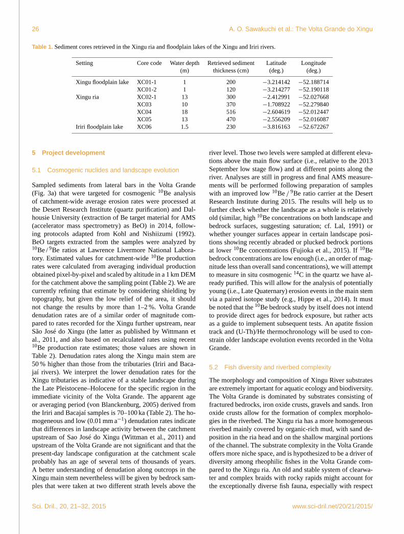
Table 1. Sediment cores retrieved in the Xingu ria and floodplain lakes of the Xingu and Iriri rivers.
Setting Core code Water depth Retrieved sediment Latitude Longitude
(m) thickness (cm) (deg.) (deg.)
Xingu floodplain lake XC01-1 1 200 −3.214142 −52.188714
XC01-2 1 120 −3.214277 −52.190118
Xingu ria XC02-1 13 300 −2.412991 −52.027668
XC03 10 370 −1.708922 −52.279840
XC04 18 516 −2.604619 −52.012447
XC05 13 470 −2.556209 −52.016087
Iriri floodplain lake XC06 1.5 230 −3.816163 −52.672267
5 Project development
5.1 Cosmogenic nuclides and landscape evolution
Sampled sediments from lateral bars in the Volta Grande
(Fig. 3a) that were targeted for cosmogenic 10Be analysis
of catchment-wide average erosion rates were processed at
the Desert Research Institute (quartz purification) and Dal-
housie University (extraction of Be target material for AMS
(accelerator mass spectrometry) as BeO) in 2014, follow-
ing protocols adapted from Kohl and Nishiizumi (1992).
BeO targets extracted from the samples were analyzed by10Be / 9Be ratios at Lawrence Livermore National Labora-
tory. Estimated values for catchment-wide 10Be production
rates were calculated from averaging individual production
obtained pixel-by-pixel and scaled by altitude in a 1 km DEM
for the catchment above the sampling point (Table 2). We are
currently refining that estimate by considering shielding by
topography, but given the low relief of the area, it should
not change the results by more than 1–2 %. Volta Grande
denudation rates are of a similar order of magnitude com-
pared to rates recorded for the Xingu further upstream, near
São José do Xingu (the latter as published by Wittmann et
al., 2011, and also based on recalculated rates using recent10Be production rate estimates; those values are shown in
Table 2). Denudation rates along the Xingu main stem are
50 % higher than those from the tributaries (Iriri and Baca-
jaí rivers). We interpret the lower denudation rates for the
Xingu tributaries as indicative of a stable landscape during
the Late Pleistocene–Holocene for the specific region in the
immediate vicinity of the Volta Grande. The apparent age
or averaging period (von Blanckenburg, 2005) derived from
the Iriri and Bacajaí samples is 70–100 ka (Table 2). The ho-
mogeneous and low (0.01 mm a−1) denudation rates indicate
that differences in landscape activity between the catchment
upstream of Sao José do Xingu (Wittman et al., 2011) and
upstream of the Volta Grande are not significant and that the
present-day landscape configuration at the catchment scale
probably has an age of several tens of thousands of years.
A better understanding of denudation along outcrops in the
Xingu main stem nevertheless will be given by bedrock sam-
ples that were taken at two different strath levels above the
river level. Those two levels were sampled at different eleva-
tions above the main flow surface (i.e., relative to the 2013
September low stage flow) and at different points along the
river. Analyses are still in progress and final AMS measure-
ments will be performed following preparation of samples
with an improved low 10Be / 9Be ratio carrier at the Desert
Research Institute during 2015. The results will help us to
further check whether the landscape as a whole is relatively
old (similar, high 10Be concentrations on both landscape and
bedrock surfaces, suggesting saturation; cf. Lal, 1991) or
whether younger surfaces appear in certain landscape posi-
tions showing recently abraded or plucked bedrock portions
at lower 10Be concentrations (Fujioka et al., 2015). If 10Be
bedrock concentrations are low enough (i.e., an order of mag-
nitude less than overall sand concentrations), we will attempt
to measure in situ cosmogenic 14C in the quartz we have al-
ready purified. This will allow for the analysis of potentially
young (i.e., Late Quaternary) erosion events in the main stem
via a paired isotope study (e.g., Hippe et al., 2014). It must
be noted that the 10Be bedrock study by itself does not intend
to provide direct ages for bedrock exposure, but rather acts
as a guide to implement subsequent tests. An apatite fission
track and (U-Th)/He thermochronology will be used to con-
strain older landscape evolution events recorded in the Volta
Grande.
5.2 Fish diversity and riverbed complexity
The morphology and composition of Xingu River substrates
are extremely important for aquatic ecology and biodiversity.
The Volta Grande is dominated by substrates consisting of
fractured bedrocks, iron oxide crusts, gravels and sands. Iron
oxide crusts allow for the formation of complex morpholo-
gies in the riverbed. The Xingu ria has a more homogeneous
riverbed mainly covered by organic-rich mud, with sand de-
position in the ria head and on the shallow marginal portions
of the channel. The substrate complexity in the Volta Grande
offers more niche space, and is hypothesized to be a driver of
diversity among rheophilic fishes in the Volta Grande com-
pared to the Xingu ria. An old and stable system of clearwa-
ter and complex braids with rocky rapids might account for
the exceptionally diverse fish fauna, especially with respect
Sci. Dril., 20, 21–32, 2015 www.sci-dril.net/20/21/2015/

A. O. Sawakuchi et al.: The Volta Grande do Xingu 27
Table 2. Fluvial sand 10Be concentration and calculated catchment-wide average denudation rates for catchments above sampling points in
the Xingu River and the Iriri and Bacajaí tributaries. Production rates obtained by averaging pixel-by-pixel the production rates calculated
according to the Lal (1991) and Stone (2000) scaling scheme, using the global production rate in Heyman (2014). Full data set given
only for samples measured in this study. For comparison of final results, we also present the final 10Be data by Wittmann et al. (2011).
AMS 10Be / 9Be ratio for the blank: 2.019± 0.425× 10⁻¹⁵. Standard used for normalization 07KNSTD3110, with a 10Be / 9Be ratio of
2.85×10⁻¹². Samples measured after adding a Be carrier solution of density 1.013 g mL−1, at a concentration of 282 ppm Be. Carrier added
to blank: 0.825 g.
Sample location, Grain size Measured AMS Be 10Be concentration Latitude Longitude Average production Denudation rate Apparent
sample ID (µm) 10Be / 9Be carrier (105 atom g−1) (deg) (deg) rate (atom g−1 y−1) (10−3 mm y−1) (ky) age
(Lat/long) ratio (10−13) (g)
Iriri before Xingu 250–710 4.8± 0.09 0.828 2.42± 0.07 −3.823547 −52.677468 3.2± 0.2 8.49± 0.08 70.6
(XIN13-01)
Xingu before Iriri 250–710 3.6± 0.06 0.822 1.78± 0.05 −4.038006 −52.594669 3.6± 0.2 13.2± 1.26 45.6
(XIN13-07)
Xingu downstream 250–710 4.2± 0.08 0.824 2.1± 0.06 −3.362553 −51.733718 3.5± 0.2 10.7± 1.0 55.9
Bacajaí (XIN13-20C)
Bacajaí 250–710 6.9± 0.13 0.818 3.45± 0.095 −3.588783 −51.763820 3.03± 0.2 6± 0.57 108.7
(XIN13-26)
Wittmann et al. (2011) (Value
sample location recalculated)
Xingu near São José 125–250 – – 2.55± 0.19 −10.763321 −53.099340 5.1± 0.3 13± 1.2 46.1
do Xingu
Xingu near São José 250–500 – – 2.32± 0.19 −10.763321 −53.099340 5.1± 0.3 14± 1.3 42.0
do Xingu
Xingu near São José 250–500 – – 2.25± 0.96 −10.763321 −53.099340 5.1± 0.3 15± 1.4 40.5
do Xingu
to lithophilic and rheophilic species like loricarid catfishes
(Fig. 4). Furthermore, the clarity of the water may enhance
the effects of substrate composition and coloration on the
color patterns of fishes, especially lithophilic species. Thus,
the concentration of suspended sediments and its variation
due to changes in hydrology and vegetation cover may play
an important role in fish evolution and ecology. Changes in
riverbed complexity and fish diversity will be monitored dur-
ing operation of Belo Monte dams. Digital elevation mod-
els (DEMs) such as SRTM (Farr et al., 2007) and ASTER
GDEM (Tachikawa et al., 2011) and bathymetric surveys will
provide information for morphometric analysis (Grohmann,
2004; Grohmann et al., 2007) of the Volta Grande region and
correlation with niche segregation among fishes.
5.3 Core description and sampling
To date, two sediment cores (XC01-2 and XC05) have been
opened for description and sub-sampling. Sediment core
XC01-2 was collected in a floodplain lake under 1 m wa-
ter depth, and it consists of ∼ 123 cm of sediments (Ta-
ble 1). The lowermost portion (123–78 cm) presents medium
to coarse sand with an overall fining upward pattern. Fine-
grained muddy sediments with colors varying from dark gray
(78–29 cm) to brown (29–0 cm) cover the sandy unit (Fig. 5).
Three samples of wood sediments for radiocarbon dating and
three samples for OSL dating were retrieved from the muddy
and sandy beds, respectively. The XC05 sediment core was
Figure 4. Diversity of sucker mouth armored catfishes (Loricari-
idae) in the Xingu River, with emphasis on lithophilous species.
Clockwise from upper left: Peckoltia vittata, Parancistrus nudiven-
tris, Panaque armbrusteri, Scobinancistrus sp., Scobinancistrus au-
reatus, Squaliforma sp., Leporacanthicus heterodon, Ancistrusra-
nunculus. Center upper: Baryancistrus xanthellus. Center lower:
Spectracanthicus zuanoni.
collected in the middle portion of the Xingu ria under a water
depth of 13 m and comprises a sediment column of∼ 470 cm
(Table 1). This sediment core is characterized by dark gray
to brown muds with rare fragments of plant material (Fig. 5).
www.sci-dril.net/20/21/2015/ Sci. Dril., 20, 21–32, 2015

28 A. O. Sawakuchi et al.: The Volta Grande do Xingu
Figure 5. (a) Retrieving of the XC03 core during November of
2014. (b) Sampling of the XC05 core (470 cm) for magnetic anal-
ysis. This core is composed of homogenous organic muddy sed-
iments. (c) Sediment column of the XC01-2 core, with a bottom
sand layer covered by dark gray to brown muds.
Sediment samples for measurements of CH4 concentration
were collected at 10 cm intervals immediately (4–5 h) follow-
ing coring, to avoid CH4 oxidation. Samples for quartz OSL
dating and for radiocarbon dating of particulate organic mat-
ter were collected at intervals of 30 to 40 cm. Samples for
pollen/spore, diatoms, magnetic minerals, and organic and
inorganic sediment geochemistry analyses were collected at
2 cm intervals.
5.4 OSL and 14C dating
The samples at 120 and 84 cm depth from core XC01-
2 were prepared for quartz OSL dating in the Lumines-
cence and Gamma Spectrometry Laboratory of the In-
stitute of Geosciences of the University of São Paulo.
These samples represent the sand bed (bar top) underly-
ing muddy sediments of the floodplain lake. Equivalent
doses (De) were estimated using the single-aliquot regen-
erative (SAR) dose protocol (Murray and Wintle, 2003)
in multigrain aliquots (180–250 µm grain size). Equivalent
doses were calculated using 24 aliquots per sample and
the Central Age Model (Galbraith et al., 1999). Radia-
tion dose rates were calculated through radionuclide con-
centrations measured using high-resolution gamma spec-
trometry. Samples at 120 and 84 cm presented sediment
deposition ages of 6987± 513 years (De= 5.89± 0.20 Gy;
dose rate= 0.843± 0.055 Gy ka−1) and 4318± 278 years
(De= 3.58± 0.10 Gy; dose rate= 0.829± 0.048 Gy ka−1),
respectively. Thus, sediment core XC01-2 records sediment
deposition since the Middle Holocene, with the floodplain
lake established approximately 4318± 278 years ago.
5.5 Magnetic analysis
Environmental magnetism techniques are used to investi-
gate the formation, transportation, and depositional and post-
depositional alterations of magnetic minerals in sediments
(Thompson and Oldfield, 1986; Evans and Heller, 2003).
Changes in the concentration, grain size and shape of mag-
netic minerals are related to climate through processes affect-
ing sediment composition and texture, such as weathering
conditions, vegetation type and erosion rates in the sediment
source areas.
Magnetic susceptibility measurements of core XC05 were
performed at the Paleomagnetic Laboratory of the Insti-
tute of Astronomy, Geophysics and Atmospheric Sciences,
University of São Paulo (IAG/USP). Paleomagnetic speci-
mens from the XC05 sediment core were collected using cu-
bic plastic boxes (8 cm3) placed side-by-side continuously
with orientation to the top–bottom, totaling 194 specimens
(Fig. 5b). Low-field magnetic susceptibility of each spec-
imen was measured using a Kappabridge MFK1-FA sys-
tem (AGICO Ltd) with two different frequencies of 976 and
15 616 Hz in a 200 A m−1 field at room temperature (Dear-
ing et al., 1996). Magnetic susceptibility values vary from
∼ 2.8× 10⁻⁸ to∼ 1.8× 10⁻⁷ m3 kg−1 (Fig. 6). Some strong
variations (peaks) may indicate variations in sedimentation
rate or different magnetic minerals present in the XC05 core.
Additional magnetic analyses will be applied to determine
the magnetic carriers and their nature.
5.6 CH4 production and emission
The Xingu ria has lake-like sedimentary dynamics and
thereby serves as an analogous setting for the future of Belo
Monte’s reservoirs. Many insights about future changes in
GHG emissions can be obtained through the study of CH4
and CO2 dissolved in the water and within the sediments of
the Xingu ria. To this end, we measured natural emissions
of GHG and collected gas samples extracted from pore wa-
ter of the XC05 core to evaluate the effect of sediment texture
and composition on the production and flux of CH4 and CO2.
CH4 and CO2 flux measurements from rivers were performed
according to Sawakuchi et al. (2014) using simultaneously
five floating chambers. At the same time, surface waters were
collected to determine gas concentration in the water after
headspace extraction. Dissolved gas concentration was cal-
culated using Henry’s law adjusted for temperature (Wiesen-
burg and Guinasso, 1979). Fluxes from soils were measured
using static chambers and procedures similar to the used by
Neu et al. (2011). Gas samples were analyzed on a Picarro
Cavity Ring Down Spectroscopy Analyzer (model G2201-
i). The CH4 concentration in pore waters from the XC05
core ranged from 0.1 to 24.5 % (Fig. 6). The stable carbon
Sci. Dril., 20, 21–32, 2015 www.sci-dril.net/20/21/2015/

A. O. Sawakuchi et al.: The Volta Grande do Xingu 29
Figure 6. Low-field magnetic susceptibility by mass normalized of
sediments and concentration CH4 (vol-%) and stable carbon iso-
topes δ13C [CH4] ‰ PDB in pore waters of XC05 sediment core.
Data plotted as a function of depth.
isotopes ratio (δ13C) in CH4 varied from −70.4 to −56.9,
pointing to a biogenic origin. More positive values of δ13C
in CH4 are related to higher magnetic susceptibility, suggest-
ing a relationship between methane oxidation and concentra-
tion of magnetic minerals. Intervals with higher δ13C in CH4
could be related to oxygen-enriched pore waters, favoring the
formation of authigenic iron oxides and increasing magnetic
susceptibility. However, additional studies for characteriza-
tion of magnetic mineral types are necessary to explain the
relationship between CH4 oxidation and magnetic suscepti-
bility. Figure 6 shows the CH4 and magnetic susceptibility
data obtained for the XC05 core.
5.7 Palynology and diatom analysis
Analyses of pollen, spores (plants and algae), diatoms, sedi-
mentary pigment degradation units (SPDU) and charred mi-
croparticles will be employed from the Xingu sediments as
proxies for the identification of climatic forcing on forest dy-
namics versus human manipulation of the local vegetation
in close interval sampling in the sediments. Diatom analy-
sis in conjunction with SPDU will provide an indirect mea-
surement of former lake levels, as well as determine possi-
ble episodes of marine water incursions into the ria system.
Changes in river dynamics and vegetation will be studied
through a proxy approach applied to the organic particles
(charcoal, pollens, spores and diatoms) in sediment cores.
Samples for palynological and diatom analysis were col-
lected in intervals of 2 cm. Establishment of vegetation dy-
namics as influenced by global patterns of climatic change
and local human manipulation of forest elements will also
help to trace local surface processes, as they share a common
temporal sequence. Lake levels, inferred from diatom and
SPDU profiles, will allow for a better understanding of water
depth variation in the lake system, and will provide means
for a better interpretation of pollen and spore signals in lake
sediments. In general, the combination of different biological
proxies will permit the evaluation of human impact on the lo-
cal Late Holocene landscape and the possible occurrence of
cultural forests, which in turn may help explain the distribu-
tion pattern of Terra Preta de Índio sites in central Amazonia.
Pollen analysis and associated biological indicators will re-
sult in a high-resolution paleocological record, which is lack-
ing for the Xingu region. Preliminary palynological analy-
ses of cores XC01-2 and XC05 indicate an abundant repre-
sentation of arboreal taxa such as Cecropia, Cedrela, Cor-
dia, Euphorbiaceae, Genipa, Fabaceae, Lecythidaceae, Mau-
ritia, Melastomataceae, Moraceae, Myrtaceae and Pouteria
and herbs belonging to the Cyperaceae and Poaceae fami-
lies. Typical taxa of open vegetation are found in low per-
centages and concentration. Regarding diatoms, sediment
cores XC01-2 and XC05 present well-preserved frustules
with species variation along the core. Core XC01-2 presents
at the base (122–98 cm) species of the genus Aulacoseira (A.
granulata, A. ambigua, A. granulata var. australiensis), indi-
cating a turbulent water environment. Diatoms are absent be-
tween 98 and 70 cm in depth, suggesting a dry period. Great
variability of genera such as Cyclotella, Discostella, Pinnu-
laria, Encyonema, Staurosira, Aulacoseira and Eunotia is
observed towards the core top (68–0 cm). Core XC05 shows
diatoms throughout the entire retrieved sediment column, but
with little variation among genera, pointing to a more uni-
form slack water environment. Representatives of the genera
Surirella, Diploneis, Aulacoseira, Placoneis, Gomphonema,
Encyonema and Eunotia were observed throughout this core.
5.8 Geochemistry
A comprehensive suite of geochemical analyses will be ap-
plied to sediment cores XC01-2 (floodplain lake site) and
XC05 (southern Xingu ria site) in order to infer patterns of
environmental change for the Xingu region. Downcore vari-
ability in organic and inorganic sedimentary components are
commonly paired with biological proxy information (e.g.,
from pollen, diatoms, benthic invertebrates, and fish fossils)
in the study of evolving floodplain lake systems (McGlue et
al., 2012; Moreira et al., 2013). Together, these data demon-
strate how climate or human activities may influence water
levels, hydrochemistry, marine connectivity, and ecological
relationships. For cores XC01-2 and XC05, inorganic geo-
chemistry will utilize carbonate coulometry and energy dis-
persive X-ray fluorescence (XRF) measurements collected
at a 2 cm interval. Considering sedimentation rates expected
for the coring sites, the 2 cm sampling interval is sufficient
www.sci-dril.net/20/21/2015/ Sci. Dril., 20, 21–32, 2015

30 A. O. Sawakuchi et al.: The Volta Grande do Xingu
to capture transitions in depositional processes that may be
responding to natural or human modification of the sur-
rounding land surface in the decadal to millennial timescales.
XRF provides both major and trace element sediment chem-
istry, which allows a robust mineralogical model to be con-
structed and potentially affords new insights into dynamic
Holocene limnological processes. Organic geochemistry will
focus on elemental analysis and stable isotopes of carbon
and nitrogen, which will be used to deduce trends in pri-
mary productivity, organic matter preservation, and prove-
nance. The synthetic multi-proxy approach we have adopted
will greatly expand paleo-record development for the region,
which may hold promise for predicting the response of this
unique aquatic ecosystem to future disturbances (Gell and
Reid, 2014).
6 Future activities
A workshop is planned for 2016 to integrate and discuss
results of environmental proxies in core sediments, cosmo-
genic nuclides, thermochronology data, greenhouse gases,
and geological correlations with fish diversity. In addition to
its unique ecological-landscape character, the Volta Grande
do Xingu is also the first clearwater river threatened by the
new round of hydropower expansion in the Brazilian Ama-
zon. Thus, lessons from the Volta Grande act as a reference
for evaluation of hydropower projects planned for other anal-
ogous rivers like the Tapajós River. Environmental impacts
of the Belo Monte dams on the Volta Grande were evaluated
based on sedimentation data for short time intervals (a few
years), considering the size and complexity of the ecologi-
cal system. Understanding past changes in hydrology, sedi-
mentation and vegetation in decadal to millennial timescales
will support more reliable predictions of future ecological
scenarios. The major challenge of the project that will be
addressed in the workshop is the integration among studies
dealing with different timescales, from the geological evo-
lution of the Volta Grande and its role in fish diversity to
modern and future influence of anthropogenic activities on
river substrates and GHG emissions. To extend the age of
environmental reconstructions, future drilling to obtain deep
sediment cores in the Xingu ria system will be discussed.
Researchers and students interested in the Xingu project are
welcome to join the workshop.
Author contributions. H. O. Sawakuchi and D. J. Bertassoli
performed greenhouse gas sampling and analyses. J. L. Antinao
contributed to rock and sediment sampling for cosmogenic nu-
clides analyses and is performing analysis of 10Be. M. Parra con-
tributed to riverbed rock sampling and thermochronology analysis.
L. M. Sousa and M. H. Sabaj Pérez contributed to fish collection and
characterization of fish diversity and river substrate. P. E. Oliveira,
R. A. Santos and V. B. Medeiros are contributing to palynology
analysis and core description. G. A. Hartmann and J. F. Savian are
contributing to magnetic analysis and 14C dating. F. N. Pupim and
C. H. Grohmann are contributing to geomorphological analysis and
maps. F. N. Pupim and A. O. Sawakuchi are contributing to OSL
dating. D. C. Bicudo and S. B. Faustino are contributing to diatom
analysis. M. McGlue is contributing to geochemical analysis (XRF,
C and N). A. O. Sawakuchi and G. A. Hartmann organized the cor-
ing collection and organized the writing of the manuscript, with
contributions of all authors.
Acknowledgements. We are very grateful for the outstanding
support of divers Dani and Ronca, boat pilots Tonho and Nelson
and cook Ilma during the field surveys. We thank the Editor
Thomas Wiersberg and the reviewers, Antje Schwalb and Hella
Wittmann-Oelze, for comments that substantially improved this
paper. A. O. Sawakuchi thanks the FAPESP (grant no. 2011/06609-
1). G. A. Hartmann thanks CAPES (grant AUXPE 2043/2014) and
CNPq (grant 454609/2014-0). F. N. Pupim thanks FAPESP (grant
no. 2014/23334-4). C. H. Grohmann is a research fellow of CNPq
(306294/2012-5) and is co-funded by a collaborative Dimensions
of Biodiversity BIOTA grant supported by grant no. 2012/50260-6,
São Paulo Research Foundation (FAPESP), the National Science
Foundation (NSF DEB-1241066), and the National Aeronautics
and Space Administration (NASA). M. Sabaj Pérez and fieldwork
were supported in part by the iXingu project, NSF DEB-1257813.
J. F. Savian thanks CNPq (grant 457802/2014-6) and FAPERGS
(grant 2329-2551/14-1).
Edited by: T. Wiersberg
Reviewed by: A. Schwalb and H. Wittmann-Oelze
References
Acselrad, H., Antonaz, D., Baines, S. G., Birindelli, J. L. O.,
Buckup, P. A., Castro, E., Couto, R. C. S., Cunha, M. A. F.,
Fearnside, P. M., Gorayeb, I., Hernández, F. M., Lima, F. C. T.,
Magalhães, A. C., Magalhães, S. B., Marin, R. A., Medeiros, H.
F., Mello, C. C. A., Molina, J., Ravena, N., Santos, G. M., Silva,
J. M., Sevá Filho, A. O., Sousa Júnior, W. C., and Vainer, C. B.:
Painel de Especialistas: Análise Crítica do Estudo de Impacto
Ambiental do Aproveitamento Hidrelétrico de Belo Monte, Or-
ganizado por Sônia Maria Simões Barbosa Magalhães Santos e
Francisco del Moral Hernandez, Belém, 29 Outubro 2009, 230
pp., 2009.
Almeida, R. M., Barros, N., Cole, J. J., Tranvik, L., and Roland,
T.: CORRESPONDENCE: Emissions from Amazonian dams,
Nature Climate Change, 3, p. 1005, doi:10.1038/nclimate2049,
2013.
Bahia, R. B. C., Faraco, M. T. L., Monteiro, M. A. S., and Oliveira,
M. A. O.: Folha SA.22-Belém, in: Carta Geológica do Brasil
ao Milionésimo. Sistema de Informações Geográficas. Programa
Geologia do Brasil, edited by: Schobbenhaus, C., Gonçalves,
J.H., Santos, J.O.S., Abram, M. B., Leão Neto, R., Matos, G.
M. M., Vidotti, R. M., Ramos, M. A. B., and Jesus, J. D. A. de,
CPRM, Brasilia, CD-ROM, 2004.
Bush, M. B., McMichael, C., Raczka, M. F., Toledo, M. B., Power,
M. J., Mayle, F. E., and de Oliveira, P. E.: The Holocene of
the Amazon, in: Paleoclimas – Série Paleontologia: Cenários de
Vida, Ed: Interciência, 5, 369–385, 2014.
Sci. Dril., 20, 21–32, 2015 www.sci-dril.net/20/21/2015/

A. O. Sawakuchi et al.: The Volta Grande do Xingu 31
Camargo, M. and Ghilardi Jr., R.: Entre a terra, as águas e os
pescadores do médio rio Xingu: uma abordagem ecológica,
Belém, PA, 329 pp., 2009.
Camargo, M., Giarrizzo, T., and Isaac, V.: Review of the geo-
graphic distribution of fish fauna of the Xingu River Basin,
Brazil, Ecotropica, 10, 123–147, 2004.
Dearing, J. A., Dann, R. J. L., Hay, K., Lees, J. A., Loveland, P. J.,
Maher, B. A., and O’Grady, K.: Frequency-dependent suscepti-
bility measurements of environmental materials, Geophys. J. Int.,
124, 228–240, 1996.
Evans, M. E. and Heller, F.: Environmental Magnetism: Principles
and Applications of Enviromagnetics, Academic, San Diego,
California, 299 pp., 2003.
Farr, T. G., Rosen, P. A., Caro, E., Crippen, R., Duren, R., Hens-
ley, S., Kobrick, M., Paller, M., Rodriguez, E., Roth, L., Seal, D.,
Shaffer, S., Shimada, J., Umland, J., Werner, M., Oskin, M., Bur-
bank, D., and Alsdorf, D.: The shuttle radar topography mission,
Rev. Geophys., 45, RG2004, doi:10.1029/2005RG000183, 2007.
Fearnside, P. M.: Dams in the Amazon: Belo Monte and Brazil’s
hydroelectric development of the Xingu River Basin, Environ.
Manage, 38, 16–27, 2006.
Fujioka, T., Fink, D., Nanson, G., Mifsud, C., and Wende, R.:
Flood-flipped boulders: In-situ cosmogenic nuclide modeling of
flood deposits in the monsoon tropics of Australia, Geology, 45,
43–46, 2015.
Galbraith, R. F., Roberts, R. G., Laslett, G. M., Yoshida, H., and Ol-
ley, J. M.: Optical dating of single and multiple grains of quartz
from Jinmium rock shelter, northern Australia: part I, experimen-
tal design and statistical models, Archaeometry, 41, 339–364,
1999.
Gell, P. and Reid, M.: Assessing change in floodplain wetland con-
dition in the Murray Darling Basin, Australia, Anthropocene, 8,
39–45, 2014.
Grohmann, C. H.: Morphometric analysis in Geographic Informa-
tion Systems: applications of free software GRASS and R, Com-
puters & Geosciences, 30, 1055–1067, 2004.
Grohmann, C. H., Riccomini, C., and Alves, F. M.: SRTM-based
morphotectonic analysis of the Pocos de Caldas Alkaline Massif,
southeastern Brazil, Computers & Geosciences, 33, 10–19, 2007.
Heckenberger, M. J., Kuikuro, A., Kuikuro, U. T., Russell, J. C.,
Schimidt, M., Fausto, C., and Franchetto, B.: Amazonia 1492:
Pristine Forest or Cultural Parkland?, Science, 301, 1710–1714,
doi:10.1126/science.1086112, 2003.
Heyman, J.: Paleoglaciation of the Tibetan Plateau and surround-
ing mountains based on exposure ages and ELA depression esti-
mates, Quaternary Sci. Rev., 91, 30–41, 2014.
Hippe, K., Ivy-Ochs, S., Kober, F., Zasadni, J., Wieler, R., Wacker,
L., Kubik, P. W., and Schlüchter, C.: Chronology of Lateglacial
ice flow reorganization and deglaciation in the Gotthard Pass
area, Central Swiss Alps, based on cosmogenic 10Be and in situ
14C, Quat. Geochronol., 19, 14–26, 2014.
Kohl, C. P. and Nishiizumi, K.: Chemical isolation of quartz
for measurement of in situ-produced cosmogenic nuclides,
Geochim. Cosmochim. Ac., 56, 3583–3587, 1992.
Lal, D.: Cosmic ray labeling of erosion surfaces; in situ nuclide
production rates and erosion models, Earth Planet. Sc. Lett., 104,
424–439, 1991.
McGlue, M. M., Silva, A., Zani, H., Corradini, F. A., Parolin, M.,
Abel, E., Cohen, A. S., Assine, M. L., Ellis, G. S., Trees, M. A.,
Kuerten, S., Gradella, F., and Rasbold, G. G.: Lacustrine records
of Holocene flood pulse dynamics in the Upper Paraguay River
watershed (Pantanal wetlands, Brazil), Quaternary Res., 78, 285–
294, 2012.
McMichael, C., Piperno, D. R., Bush, M. B., Silman, M. R., Zim-
merman, A. R., Raczka, M. F., and Lobato, L. C.: Sparse pre-
Columbian human habitation in western Amazonia, Science,
336, 1429–1431, 2012a.
McMichael, C., Bush, M. B., Piperno, D., Silman, M. R., Zimmer-
man, A. R., and Anderson, C.: Scales of pre-Columbian distur-
bance associated with western Amazonian lakes, The Holocene,
22, 131–141, 2012b.
Moreira, L. S., Moreira-Turcq, P., Turcq, B., Cordeiro, R. C.,
Kim, J.-H., Caquineau, S., Magloire, M.-Y., Macario, K. D., and
Sinninghe-Damsté, J. S.: Palaeohydrological controls on sed-
imentary organic matter in an Amazon floodplain lake, Lake
Maracá (Brazil) during the late Holocene, The Holocene, 23,
1903–1914, 2013.
Murray, A. S. and Wintle, A. G.: The single aliquot regenerative
dose protocol: potential for improvement in reliability, Radiat.
Meas., 37, 377–381, 2003.
Neu, V., Neill, C., and Krusche, A. V.: Gaseous and fluvial carbon
export from an Amazon forest watershed, Biogeochemistry, 105,
133–147, 2011.
Nogueira, C., Buckup, P. A., Menezes, N. A., Oyakawa,
O. T., Kasecker, T. P., Ramos Neto, M. B., and Silva,
J. M. C. da: Restricted-range fishes and the conserva-
tion of Brazilian freshwaters, PLoS ONE, 5, e11390,
doi:10.1371/journal.pone.0011390, 2010.
Ometto, J. P., Cimbleris, A. C. P., Santos, M. A., Rosa, L. P., Abe,
D., Tundisi, J. G., Stech, J. L., Barros, N., and Roland, F.: Car-
bon emission as a function of energy generation in hydroelec-
tric reservoirs in Brazilian dry tropical biome, Energ. Policy, 58,
109–116, 2013.
Sabaj Pérez, M.: Where the Xingu Bends and Will Soon Break, Am.
Sci., 103, 395–403, doi:10.1511/2015.117.395, 2015.
Sawakuchi, H. O., Bastviken, D., Sawakuchi, A. O., Krusche,
A. V., Ballester, M. V. R., and Richey, J.: Methane emis-
sions from Amazonian Rivers and their contribution to the
global methane budget, Glob. Change Biol., 20, 2829–2840,
doi:10.1111/gcb.12646, 2014.
Silva, F. A. and Rebellato, L.: Use space and formation of Terra
Preta: the Asurini do Xingu case study, in: Amazonian dark
earths: explorations in space and time, edited by: Lehmann, J.,
Kern, D., Galser, B., and Woods, W. I., New York, Springer, 159–
168, 2003.
Sioli, H.: Amazônia: Fundamentos de Ecologia da Maior Região de
Florestas Tropicais, EditoraVozes, Petrópolis, 72 pp. 1985.
Sousa, W. C. and Reid, J. B.: Uncertainties in Amazon hydropower
development: Risk scenarios and environmental issues around
the Belo Monte dam, Water Alternatives, 3, 249–268, 2010.
Stickler, C. M., Coe, M. T., Costa, M. H., Nepstad, D. C., McGrath,
D. G., Dias, L. C. P., Rodrigues, H. O., and Soares-Filho, B. S.:
Dependence of hydropower energy generation on forests in the
Amazon basin at local and regional scales, P. Natl. Acad. Sci.
USA, 110, 9601–9606, 2013.
Stone, J. O.: Air pressure and cosmogenic isotope production, J.
Geophys. Res.-Sol. Ea., 105, 23753–23759, 2000.
www.sci-dril.net/20/21/2015/ Sci. Dril., 20, 21–32, 2015

32 A. O. Sawakuchi et al.: The Volta Grande do Xingu
Tachikawa, T., Hato, M., Kaku, M., and Iwasaki, A.: Characteristics
of ASTER GDEM version 2, Geoscience and Remote Sensing
Symposium (IGARSS), 2011 IEEE International, 3657–3660,
2011.
Thompson, R. and Oldfield, F.: Environmental Magnetism, London,
Allenand Unwin., doi:10.1007/978-94-011-8036-8, 1986.
von Blanckenburg, F.: The control mechanisms of erosion and
weathering at basin scale from cosmogenic nuclides in river sed-
iment, Earth Planet. Sc. Lett., 237, 462–479, 2005.
Wiesenburg, D. A. and Guinasso, N. L.: Equilibrium solubilities
of methane, carbon-monoxide, and hydrogen in water and sea-
water, J. Chem. Eng. Data, 24, 356–360, 1979.
Wittmann, H., von Blanckenburg, F., Maurice, L., Guyot, J.-L., Fil-
izola, N., and Kubik, P. W.: Sediment production and delivery in
the Amazon River basin quantified by in situ–produced cosmo-
genic nuclides and recent river loads, Geol. Soc. Am. Bull., 123,
934–950, 2011.
Wohl, E. E. and Merritt, D. M.: Bedrock channel morphology, Geol.
Soc. Am. Bull., 113, 1205–1212, 2001.
Zuanon, J.: História natural da ictiofauna de corredeiras do Rio
Xingu, na região de Altamira, Pará, Unpublished Ph.D. disser-
tation, Instituto de Biologia da Universidade Estadual de Camp-
inas, 183 pp., 1999.
Sci. Dril., 20, 21–32, 2015 www.sci-dril.net/20/21/2015/