thematic history - high ground consulting · thematic history of the former coonabarabran shire 2...
TRANSCRIPT
Thematic History of the former
Coonabarabran Shire
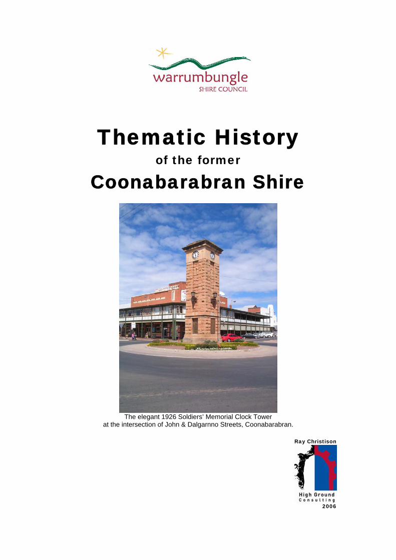
The elegant 1926 Soldiers’ Memorial Clock Tower
at the intersection of John & Dalgarnno Streets, Coonabarabran.
Ray Christison
2006
Thematic history of the former Coonabarabran Shire 2
Contents Section Page Introduction 4 1. Tracing the evolution of the Australian environment 6 1.1 Environment: Naturally evolved ……………………… 6 2. Peopling Australia 8 2.1 Aboriginal cultures and interactions with other cultures ………. 8 2.2 Convict ………………………………………………. 13 2.3 Ethic influences ………………………………………………. 14 2.4 Migration ………………………………………………. 17 3. Developing local, regional and national economies 21 3.1 Agriculture ………………………………………………. 21 3.2 Commerce ……………………………………………….. 23 3.3 Communication ……………………………………………….. 26 3.4 Environment – Cultural landscape ……………………….. 27 3.5 Events ……………………………………………….. 28 3.6 Exploration ……………………………………………….. 29 3.7 Fishing ……………………………………………….. 30 3.8 Forestry ……………………………………………….. 30 3.9 Health ……………………………………………….. 33 3.10 Industry ……………………………………………….. 35 3.11 Mining ……………………………………………….. 36 3.12 Pastoralism ……………………………………………….. 36 3.13 & 3.14 Science & Technology ……………………………….. 41 3.15 Transport ……………………………………………….. 43 4. Building settlements, towns and cities 49 4.1 Accommodation ……………………………………………….. 49 4.2 Land Tenure ……………………………………………….. 50 4.3 Towns, suburbs and villages ……………………………….. 51 4.4 Utilities ……………………………………………….. 54 5. Working 58 5.1 Labour ……………………………………………….. 58 6. Educating 63 6.1 Education ……………………………………………….. 63 7. Governing 66 7.1 Defence ……………………………………………….. 66 7.2 Government and administration ……………………………… 66 7.3 Law and order ……………………………… 68 7.4 Welfare ……………………………… 69
Ray Christison Version 1 17.7.06
Thematic history of the former Coonabarabran Shire 3
Contents Section Page 8. Developing Australia’s cultural life 72 8.1 Creative endeavour ………………………………. 72 8.2 Domestic life ………………………………. 73 8.3 Leisure ………………………………. 74 8.4 Religion ………………………………. 76 8.5 Social institutions ………………………………. 78 8.6 Sport ………………………………. 79 9. Marking the phases of life 82 9.1 Birth and death ………………………………... 82 9.2 Persons ………………………………… 84 10. References 89
Ray Christison Version 1 17.7.06
Thematic history of the former Coonabarabran Shire 4
Introduction The thematic history of the former Coonabarabran Shire Locally based researchers and historians have very ably recorded many aspects of the story of the Coonabarabran district through a series of historical narratives, reminiscences and oral histories. Published histories include Joy Pickette and Mervyn Campbell’s history of Coonabarabran prior to 1900, Robyn Bull’s pictorial history of Binnaway, Margaret Somerville’s collection of oral histories of the people of Burrabeedee, John Whitehead’s precise analyses of the exploratory journeys of Oxley and Evans, Eric Rolls’ account of the development and metamorphosis of the Pilliga, Elva Shumack’s warm and engaging account of post World War II soldier settlement in the Goolhi area and Russell Bright’s memoirs of life on the railway. Local history resources include much other published and unpublished research. This thematic history has been prepared as part of a community based heritage study undertaken in the former Coonabarabran Shire in 2005-2006. It gratefully acknowledges the work of local researchers in recording the development of the region. Published and unpublished local history resources, and national reference materials, have been referred to in the preparation of this history, and as far as possible the recollections of current and former residents of the shire have been included in the study. This is not intended to be a comprehensive history of the former Coonabarabran Shire. Those who are seeking more detailed explanations of people, places and events are encouraged to refer to the works cited in the reference list that is included in Section 10 References. Where gaps have existed in existing narratives attempts have been made to provide a more detailed analysis. This particularly applies to the story of local government in the 20th century. Special thanks for assistance with preparing and editing this history should go to Jewell Toynton and the workers of the Coonabarabran DPS Local and Family History Group Inc who provided access to oral histories and valuable information on the development of Coonabarabran and surrounding districts, Judith Hadfield of Baradine who researched and supplied information on the Baradine district and the timber industry of the Pilliga and Colin Millard of Lithgow who provided reference materials on the development of the railway through the area. This history should not be treated as a definitive history. Other researchers are encouraged to add to the written record of the vast, complex and unfolding story of the Coonabarabran region. The Australian Historic Themes This thematic history is designed to tell the story of the former Coonabarabran Shire within a consistent national framework. This framework was designed by the Australian Heritage Commission to organise information on the history of places into areas of activity.
By emphasising the human activities that produced the places we value, and the human response to Australia’s natural environment, places are related to
Ray Christison Version 1 17.7.06
Thematic history of the former Coonabarabran Shire 5
the processes and stories associated with them, rather than the type of function or place … Themes are not intended to follow a chronological order. Rather, they are generic, and designed to be applied and interlinked, regardless of the period or place. They embrace prehistory to the modern period and a multiplicity of human activities.1
This history has been organised within each National Historic Theme under the relevant New South Wales Historic Themes. The New South Wales themes are dealt with in alphabetical order under the general heading of the national themes.
1 Australian Historic Themes Framework, 2001.
Ray Christison Version 1 17.7.06
Thematic history of the former Coonabarabran Shire 6
1. Australian Historical Theme: Tracing the evolution of the Australian environment
The environment exists apart from being a construct of human consciousness. However, a thematic approach recognises the human factor in the natural environment, and how our understanding and appreciation of the environment has changed over time.2 1.1 NSW Historical Theme: Environment – naturally evolved The entire Warrumbungle Shire, containing the former Coonabarabran and Coolah Shires, sits within the Darling Plains Heritage Region. This region was defined in 19963. The Heritage Office briefly defined the Darling Plains region as follows:
Broken country separates New England from the level Darling Plain to the west. Defined by aridity on its western boundary, signified by the shift from woodland to scrub and bushland, it extends over the plains draining rivers to the Darling, including subregions such as Liverpool Plains and the Pilliga Scrub.4
This area is included in the Brigalow Belt South Biodiversity Region5. The geology and biodiversity of the region have been described in the Brigalow Belt South, NSW Bioregional Conservation Assessment Scoping Report. The geology of the Warrumbungles and Pilliga State Forests have also been adequately described by Whitehead in his work on the path of explorers Oxley and Evans6. The landforms of the area can be generally described as follows:
• Liverpool Plains … extensive black soil plains punctuated by low sedimentary and volcanic hills. The grasslands and open woodlands on the alluvial plains and foot slopes of the hills have been mainly cleared and are used for cropping.
• Pilliga Outwash … a gently undulating plain of deep sandy soils formed by outwash from the sandstone hills to the east. Some of the more productive soils around the margins … have been cleared for agriculture but most of the higher areas remain covered by State forests.
• Pilliga … contains extensive sandstone hills with areas of higher basalt peaks and has predominantly sandy soils. Much of the forest has been cleared, but there are large areas of State forest, especially on lands with rockier or shallower soils.7
The entire area is a cultural landscape that shows clear evidence of management by human beings for thousands of years. One of the most amazing stories of the area lies in the transformation of the Pilliga since its appropriation by European settlers. The first European explorers described an open, slightly wooded landscape. This 2 Australian Historic Themes Framework, 2001. 3 Heritage Office, 1996. Regional Histories. p.13 4 Heritage Office, 1996. Regional Histories. p.15 5 Brigalow Belt South, NSW Bioregional Conservation Assessment Scoping Report. pp.9-13 6 Whitehead, J., 2004. Tracking & Mapping the Explorers Vol. 2. pp.176-177 & 193-194 7 Brigalow Belt South, NSW Bioregional Conservation Assessment Scoping Report. pp.12-13
Ray Christison Version 1 17.7.06
Thematic history of the former Coonabarabran Shire 7
landscape had been created by Aboriginal land management practices and the presence of seed eating kangaroo rats. Early European settlers had a saying that one could gallop a horse through the Pilliga on a moonlit night. Changes in land management practice brought in by these settlers eventually led to the dramatic re-forestation of the area in the late 19th century. This process is described in more detail in Section 3.8 Forestry. The Warrumbungle Range is the outstanding natural feature of the region and dominates the horizon of many parts of the shire. Much of the range has been declared as national park. The park encapsulates the major features of the former massive Warrumbungle volcano that is believed to have been active around 17 million years ago. It is one element of the impact of the movement of the Indo-Australian Plate over a stationary hot spot in the earth’s crust over tens of millions of years.8 The modern landscape is the result of:
Thirteen million years of rain, wind and ice (that) have eaten away at the structure, stripping off successive layers of ash and lava to expose the volcano’s inner workings … (creating) the dramatic landscape of today’s Warrumbungle Range.9
Significant natural sites within the former Coonabarabran Shire include the Warrumbungle National Park, Mow Rock, Scabby Rock and the Chalk Mountain Area. The clear, dark skies of the area have made it an ideal location for astronomy. The Siding Springs Observatory that has been developed since 1965 is a significant site in the development of Australian astronomy.
8 Fox, P., 1996. Warrumbungle National Park. pp.10-11 9 Fox, P., 1996. Warrumbungle National Park. p.13
Ray Christison Version 1 17.7.06
Thematic history of the former Coonabarabran Shire 8
2. Australian Historical Theme: Peopling Australia This theme group recognises the pre-colonial occupations of Indigenous people, as well as the ongoing history of human occupation from diverse areas.10 2.1 NSW Historical Theme: Aboriginal cultures and interactions with other cultures The area covered by the former Coonabarabran Shire sits at the convergence of the territories of three Aboriginal language groups, the Gamilaraay to the northeast, the Wiradjuri to the south and the Wayilwan to the west11. Archaeological evidence suggests that Aboriginal people have occupied the land to the east of Coonabarabran for up to 25,000 years and in the Warrumbungle Ranges for up to 17,000 years12. Numerous cultural sites testify to the complexity of Aboriginal culture and the people’s relationship with the land.
The inextricable bond between life and land is a fundamental premise of Aboriginal existence. All features of the landscape, and all life within it, was created during a creation period by ancestral creatures; some human, some animal, some neither. This period … is present in the landscape itself, and the stories and relationships form an integral part of the traditional law that guides all life. This relationship to the land extends to an in-depth knowledge of the incredible wealth of resources available in the local area, including foodstuffs and raw materials for tool and implement manufacture.13
Josephine Flood has noted that “if a time scale of human occupation of Australia were represented by one hour on a clock, Aboriginal society would occupy over fifty-nine and a half minutes, European society less than half a minute”14. Despite the fact that the story of the Aboriginal people is “the longest continual cultural history in the world”15 Somerville notes that “the threads of the story have been broken” 16. Fragments of the past must be drawn together to attempt to understand the history of the first people of this region. Specific Aboriginal sites around Coonabarabran that have been identified and studied include Kawambarai Cave, Crazy Man Cave, the cave containing the ‘girl with the dilly bag’17, Tara Cave and many other rock shelters, open campsites and scarred trees18. Some caves in the Warrumbungle Ranges contain hand stencils and engravings19 and bora grounds are located in a number of places. Grinding grooves are evident on the rocks of the Castlereagh River at Willow Vale, close to the centre of Coonabarabran. 10 Australian Historic Themes Framework, 2001. 11 Somerville, M. et al, 1994. The Sun Dancin’, People and Place in Coonabarabran. pp.46-47 12 Fox, P., 1996. Warrumbungle National Park. p.52 13 Fox, P., 1996. Warrumbungle National Park. p.48 14 Flood, J., Archaeology of the Dreamtime, p.15 15 Flood, J., Archaeology of the Dreamtime, p.15 16 Somerville, M. et al, 1994. The Sun Dancin’, People and Place in Coonabarabran. p.25 17 Somerville, M. et al, 1994. The Sun Dancin’, People and Place in Coonabarabran. pp.28-43 18 Fox, P., 1996. Warrumbungle National Park. pp.50-51 19 Fox, P., 1996. Warrumbungle National Park. p.51
Ray Christison Version 1 17.7.06
Thematic history of the former Coonabarabran Shire 9
In her account of the Aboriginal people of Coonabarabran Somerville quoted from Police Sergeant Ewing’s diary recordings of the tales he had learned as a child from Jinnie Griffin. These recordings include an account of a battle between the local Aboriginal people and a raiding party from the area now known as Cassilis. The raiding party was chased by the men of the local group to caves above the present day Coonabarabran and slaughtered. 20 This story contains many elements of what is considered to be the traditional pattern of warfare between Aboriginal groups, the aim of which was ‘to continually assert the superiority of one’s groups over neighbouring groups’.21 Ewing recorded other reminiscences of Aboriginal people, including accounts of raiding parties that were later used by author Ion Idress in developing works of historical fiction such as The Red Chief of the Gunnedah Tribe. Ewing’s papers include the following description of the Coonabarabran group:
They are numerous that Coonabarabran tribe and have their camps large ones miles apart – but there are small parties camped in numerous places – some within a day’s walk of here up in the mountains there Warrumbungles there are many many caves – great ones that our whole tribe could fill – up there in the daylight you could see a man coming up the mountain a half day before he could get up to you. … we came down to the scrubby land and day after day watched parties of women and children leave camp to go fishing – musselling in creeks and rivers and hunting small game.22
The first European record of the Aboriginal people of the district comes from the journals of John Oxley who passed through in August 1818. Oxley, apparently depressed by the difficulty of his passage through ‘these desolate wilds’23, refers a number of times to ‘the fires of the natives’ who ‘attend on our motions pretty closely’24 and ‘the natives who continue in our vicinity unheeded and unheeding’.25 As squatters began to move into the country from the 1830s (refer to Section 3.12 Pastoralism), starting a struggle for resources, tensions began to be recorded. Connor recounts a series of incidents in 1837 that led to a punitive expedition by the NSW Mounted Police.
Kamilaroi (Gamilaraay) women were being abducted by stockmen and this probably led Kamilaroi men to kill Frederick Harrington in June at Charles Purcell’s station in the Warrumbungles. On 21 September Lieutenant George Cobban of the 50th Regiment, commanding the Hunter River division of the Mounted Police, was ordered to look for Harrington’s killers.26
20 Somerville, M. et al, 1994. The Sun Dancin’, People and Place in Coonabarabran. pp.54-55 21 Connor, J., 2002. The Australian Frontier Wars 1788-1838, p.2 22 Carmichael, D., 1991. Timor Valley, p.7 23 Whitehead, J., 2005. Tracking and Mapping the Explorers Vol. 2. p.184 24 Whitehead, J., 2005. Tracking and Mapping the Explorers Vol. 2. p.179 25 Whitehead, J., 2005. Tracking and Mapping the Explorers Vol. 2. p.184 26 Connor, J., 2002. The Australian Frontier Wars. p.107
Ray Christison Version 1 17.7.06
Thematic history of the former Coonabarabran Shire 10
The expedition travelled hundreds of kilometres from its base at Jerry’s Plains without finding a culprit. In 1838 a more serious expedition, reminiscent of the pattern of earlier British military expeditions against the Darug on the Hawkesbury, the Wiradjuri on the Cudgegong and the Wonnarua on the Hunter, Major James Nunn of the Mounted Police led an expedition to the Peel, Gwydir and Namoi Rivers. This party surrounded a Gamilaraay camp on Waterloo Creek, southwest of the present day Moree around 26 January 1838. In a brief battle possibly 50 Aboriginal people were killed.27 This event caused alarm in government circles but response to it was overwhelmed by the Myall Creek massacre later in the same year and an escalation of conflict around the Port Phillip District.28 Aboriginal people of the region resisted incursions into their land, loss of resources and sexual exploitation. The loss of societal cohesion and impact of disease among Aboriginal people has been recorded in a number of places. These severely hampered the society’s capacity to resist occupation of their lands, but it is clear that resistance continued for an extended period. In response to a situation of escalating violence on this and other frontiers of the colony Governor Gipps established the Native Police in 1839. Originally intended to protect all interests this force was allowed:
… to operate to protect settlers. White officers in charge of Aboriginal troopers, had substantial independence of the local magistracies and operated in accordance with the tradition of the punitive expedition, which was common enough in establishing colonies.29
The violent suppression of Aboriginal peoples was one aspect of this period of colonisation. During the same period Aboriginal people began to work on the properties being developed by the settlers. Mary Cain, who was born at Toorawindi in 1844, recalled that, during the gold rushes of the 1850s, European workers left the pastoral stations to head to the goldfields. She noted that James Orr and Robert Campbell of Borah station tried labour from India. This was unsuccessful and Orr later employed Chinese workers. These were more successful but Aboriginal people ‘made the best servants … and were kindly treated’.30 Ebenezer Orr leased a number of properties around Yaminbah Creek. He readily employed Aboriginal people and particularly favoured women whom he dressed in red flannel. He lived with at least two of these shepherdesses in a house he built on Yaminba Creek31. Mary Cain was born amidst the apparent frontier chaos of the 1840s. She has been described as a ‘larger-than-life-figure’32 who grew to create a unique legacy for the Aboriginal people of Coonabarabran. She was born to Jinnie and Eugene Griffin and grew up to be a shepherd. Jinnie was described by Sergeant Ewing as ‘the consort of
27 Connor, J., 2002. The Australian Frontier Wars. p.107-111 28 Connor, J., 2002. The Australian Frontier Wars. p.113 29 Rowley, C.D., 1978. The Destruction of Aboriginal Society. p.39 30 Cain, M. 1923. ‘Coonabarabran in the ‘Sixties’. p.370 31 Rolls, E., 1982. A Million Wild Acres. p.171 32 Somerville, M. et al, 1994. The Sun Dancin’, People and Place in Coonabarabran. p.51
Ray Christison Version 1 17.7.06
Thematic history of the former Coonabarabran Shire 11
King Cutttabush of the Coonabarabran blacks, a small scattered wandering band that is still represented at Burrabeedee Mission Station’33. Mary married George Cain, a shearer, and by 1892 was living with George and their five children at Forky Mountain north of Coonabarabran. She had agitated for recognition of ownership of the 400 acres of land that she and George had taken up and were developing as a farm. Forked Mountain Station was gazetted on 6 February 189234.
The story of Burrabeedee is quite a different one from the usual story of Aboriginal people being forced into reserves and missions and governed by officialdom beyond their control. In Mary Jane’s case, she claimed the land on behalf of her family, and people came from all around the district when they heard ‘she had made a reserve for the dark people’.35
The grant of land at Forky Mountain appears to have occurred under the auspices of the NSW Aborigines Protection Board that had been founded in 1883. This board had granted 114 reserves to Aboriginal people by 1895 ‘and of these 72 had been as a direct result of Aboriginal initiative and pressure’.36 Mary Cain not only founded Burrabeedee but also was an influential and respected citizen of Coonabarabran from whom other civic leaders sought advice. Burrabeedee has stood as an early example of Aboriginal people taking responsibility for their own wellbeing within a colonial economy. Maynard notes that this was not uncommon, with over 80 per cent of Aboriginal people in NSW being self-sufficient by the beginning of the 20th century, ‘combining European farming with traditional methods of food production’. After World War I revocation of Aboriginal farms commenced and there was a ‘sudden acceleration of taking Aboriginal children from their families’37. Burrabeedee was subsumed into the government controlled welfare system and the buildings eventually sold off (refer to Section 7.4 Welfare). The government was empowered to take direct control of Burrabeedee under the provisions of the NSW Aborigines Protection Act that had been passed by the NSW Parliament in 1909. According to Faith Bandler this legislation:
… was an Act that denied equality to the Aboriginal people, that made them second-class citizens. It meant that their lives could be dominated by station managers, that their homes could be entered by police, that if a friend asked them to share a quiet drink they could be arrested and gaoled.38
The provisions of the Aborigines Protection Act included a ban on the supply or consumption of alcohol. This ban lasted until the 1960s and was one of many small
33 Somerville, M. et al, 1994. The Sun Dancin’, People and Place in Coonabarabran. p.53 34 Somerville, M. et al, 1994. The Sun Dancin’, People and Place in Coonabarabran. p.76 35 Somerville, M. et al, 1994. The Sun Dancin’, People and Place in Coonabarabran. pp.76-77 36 Maynard, J. For Liberty and Freedom: Fred Maynard and the Australian Aboriginal Progressive Association. 37 Maynard, J. For Liberty and Freedom: Fred Maynard and the Australian Aboriginal Progressive Association. 38 Bandler, F & Fox, L. (eds), 1983. The Time was Ripe.
Ray Christison Version 1 17.7.06
Thematic history of the former Coonabarabran Shire 12
injustices that created resentment among the Aboriginal community. May Mead recalled the discrimination which occurred to her father after his service in World War I:
Dad was in the war and his (five) other brothers , so there was three of them came home. The others were killed. Their names are on the town clock here in Coonabarabran … that’s about all they did … because when they came back from the war they were never allowed in a hotel. And they didn’t have rights to their country or anything else. If there was something on for the soldiers, the returned soldiers, they could go but they felt like outsiders, yet they fought for their country and to me that was very, very wrong.39
A number of Aboriginal men from the district had served in the Australian Imperial Force in World War I. These included Tommy Fuller of Baradine who was wounded at Passchendaele in 1917 and Bill Chatfield who served in the Light Horse40. The Aborigines Protection Board took over the management of Burrabeedee. A number of houses were built on the settlement, however it appears that administration and maintenance were chronically under-resourced. Living conditions on many Aboriginal reserves administered by the Board were described as ‘very low indeed’41. During the 1940s the Coonabarabran Shire Council had cause on more than one occasion to formally express its concern to the Aborigines Protection Board about the poor condition of the houses at Burrabeedee and request that the Board invest resources into maintenance42. The recollections of the people of Burrabeedee indicate that living conditions were better than on many Aboriginal missions. The people maintained livestock, grew fruit and vegetables and gathered bush tucker to ensure a balanced diet. Houses were kept neat and tidy and the strength of community can be recognised in the many gatherings and celebrations that were held there. The strength of Burrabeedee lay in the fact that those who lived there had chosen it as their place of residence and they maintained a strong sense of ownership despite the restrictions placed on them by the Aborigines Protection Act. During the 1950s the official policy of governments changed from protection to assimilation. Changes in administration encouraged the residents of Burrabeedee to move into Coonabarabran. In 1954 the school at Burrabeedee closed down and over succeeding years the settlement was gradually dismantled by the government. Some houses and the school were sold off and moved on to various properties around Coonabarabran43. An ‘Aborigines Reserve’ was set aside in Portion 47 of the Town of Coonabarabran between North, Namoi and White Streets44. The church from Burrabeedee was relocated to the new Aboriginal housing project in Coonabarabran known as Gunnedah Hill.45
39 Somerville, M. et al, 1994. The Sun Dancin’, People and Place in Coonabarabran. pp.137-138 40 Huggonson, D., 1993. ‘Aboriginal Diggers of the 9th Brigade, first AIF’. pp.218&225 41 Bandler, F & Fox, L. (eds), 1983. The Time was Ripe. 42 Minutes of Coonabarabran Shire Council, 1942 43 Somerville, M. et al, 1994. The Sun Dancin’, People and Place in Coonabarabran. pp.188-193 44 Local Government, Dept. of. (undated). Town of Coonabarabran – map. 45 Somerville, M. et al, 1994. The Sun Dancin’, People and Place in Coonabarabran. pp.188-193
Ray Christison Version 1 17.7.06
Thematic history of the former Coonabarabran Shire 13
Not all Aboriginal people lived at Burrabeedee. Many families lived and worked in the townships of the shire, including Baradine and Coonabarabran. Somerville recounted the recollections of some of these people who experienced life on the fringes of the community. Others lived within the township of Coonabarabran. 2.2 NSW Historical Theme: Convict Many of the first European settlers in the region were assigned convicts who worked as shepherds and labourers for the squatters.
The normal fate of the well-behaved convict was assignment to private service. … the British government encouraged it, for it saved money by taking the prisoner off the government’s hands. … It scattered men throughout the colony, which broke up their ‘evil associations’, it taught the convicts those ‘habits of labour’ whose absence had so often started them on their criminal career, and it gave them experience, which would make it easier for them to gain useful employment when their sentence expired.46
Writing in 1839 Charles Campbell indicated that the shepherd’s life was excellent for reforming the behaviour of criminals:
He who leads it has constant but not laborious employment, enjoys the light of heaven and … is secluded from the company of the drunken and dissolute.47
Assignment created a cheap labour force that assisted many early free settlers to prosper. Convicts were sent with flocks of sheep beyond the limits of the colony (refer Section 4.2 Land Tenure) to become the vanguard of European settlement in areas such as those surrounding the Warrumbungle Mountains. Convicts and ex-convicts were in many cases the first Europeans with whom Aboriginal people had substantial contact. Colonial governments encouraged assignment of convicts as it was a far cheaper method of keeping them than maintaining them in penitentiaries or on road gangs. In 1837 it cost £17 per year to keep a convict on a chain gang. A convict on assignment cost £4.48 Landholders reaped the benefit of the cheap labour force provided by assigned convicts to build up their fortunes. In his return of 2 June 1839 Lands Commissioner Graham Hunter stated that 115 free men and 10 convicts were working on Bomera station. The 1841 Census recorded 21 single males living at Bomera. All had arrived in the colony as convicts. At the time of the census 10 were free, two had tickets of leave and nine were privately assigned. 10 of these men were working as shepherds. Of these men four nominated their denomination as Church of England, one as Church of Scotland and 16 as Roman Catholic.49 Political unrest in Ireland and the desire of English courts to clear criminals from the areas around London ensured that many convicts came from these areas. 46 Shaw, A., 1977. Convicts and the Colonies. p.217 47 Shaw, A., 1977. Convicts and the Colonies. p.217 48 Shaw, A., 1977. Convicts and the Colonies. p.254 49 Cameron, R. The Village Town with the Big Heart. p.97
Ray Christison Version 1 17.7.06
Thematic history of the former Coonabarabran Shire 14
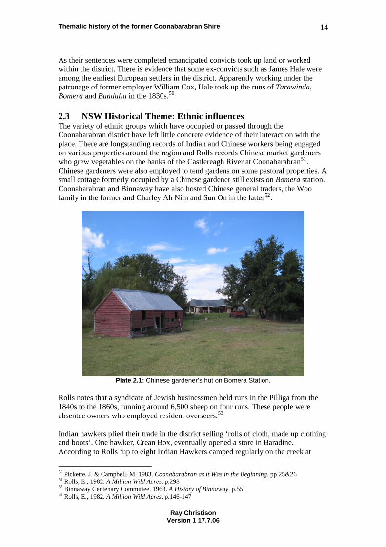
As their sentences were completed emancipated convicts took up land or worked within the district. There is evidence that some ex-convicts such as James Hale were among the earliest European settlers in the district. Apparently working under the patronage of former employer William Cox, Hale took up the runs of Tarawinda, Bomera and Bundalla in the 1830s.50 2.3 NSW Historical Theme: Ethnic influences The variety of ethnic groups which have occupied or passed through the Coonabarabran district have left little concrete evidence of their interaction with the place. There are longstanding records of Indian and Chinese workers being engaged on various properties around the region and Rolls records Chinese market gardeners who grew vegetables on the banks of the Castlereagh River at Coonabarabran51. Chinese gardeners were also employed to tend gardens on some pastoral properties. A small cottage formerly occupied by a Chinese gardener still exists on Bomera station. Coonabarabran and Binnaway have also hosted Chinese general traders, the Woo family in the former and Charley Ah Nim and Sun On in the latter52.
Plate 2.1: Chinese gardener’s hut on Bomera Station.
Rolls notes that a syndicate of Jewish businessmen held runs in the Pilliga from the 1840s to the 1860s, running around 6,500 sheep on four runs. These people were absentee owners who employed resident overseers.53 Indian hawkers plied their trade in the district selling ‘rolls of cloth, made up clothing and boots’. One hawker, Crean Box, eventually opened a store in Baradine. According to Rolls ‘up to eight Indian Hawkers camped regularly on the creek at
50 Pickette, J. & Campbell, M. 1983. Coonabarabran as it Was in the Beginning. pp.25&26 51 Rolls, E., 1982. A Million Wild Acres. p.298 52 Binnaway Centenary Committee, 1963. A History of Binnaway. p.55 53 Rolls, E., 1982. A Million Wild Acres. p.146-147
Ray Christison Version 1 17.7.06
Thematic history of the former Coonabarabran Shire 15
Bugaldie. They brought fowl for a communal meal … cooked chapatis over an open fire in folding gridirons …Then all dipped into the same big pot of curried chicken’54. An Indian hawker named Nordean supplied ‘clothing, haberdashery and food’ to the workers of Pilliga timber mills in the 20th century55. German migrants are known to have cultivated vineyards in the area. In the 19th century it was common for immigrants from Germany seek out opportunities for the establishment of vineyards to supply the local wine trade. The most durable ethnic influences exist in the from of churches and the headstones of cemeteries. The various sections of the Coonabarabran General Cemetery contain headstones that stand as a testament to the ethnic origins of the occupants of the graves. The Golden Sea Dragon Chinese Restaurant is the most outstanding example of ethnic influence in modern Coonabarabran. This building on John Street is a strong statement of Chinese identity and contains a spectacularly carved wooden interior. 2.3.1 Italian prisoners of war 1943-1946 Following the spectacular military successes of British Empire forces in North Africa in 1940 British authorities were saddled with responsibility for 130,000 Italian prisoners of war. The majority of these prisoners were transported to camps in Australia, India, South Africa and Ceylon (Sri Lanka). Initially Italian prisoners sent to Australia were housed in large prisoner of war camps. Soldiers below the rank of officer were given farming and construction tasks in various areas. By 1943 Australia was experiencing a deteriorating supply of manpower. At this time British authorities in India requested that Australia consider taking an additional 20,000 prisoners of war to assist in overcoming this problem. The Australian government considered this matter and in April 1943 gave approval for small groups of Italian prisoners of war to be employed on individual farms. The prisoners were to be paid by the employing farmers and provided with accommodation and food. To administer this program Prisoner of War Control Centres were established in regional centres. Each Control Centre was operated by:
… an army complement of seven whose task was to supply prisoners with their needs, maintain supervision and deal with employers’ complaints and liaise with police in the event of a POW running away. Up to 200 Italians were to be placed with private employers on farms within a radius of 40 kilometres from each Control Centre.56
Initial Prisoner of War Control Centres were established at Parkes, Coonabarabran and Orange in June 1943 with the first of these being established at Coonabarabran. The Coonabarabran Control Centre operated until January 1946. It was in operation
54 Rolls, E., 1982. A Million Wild Acres. p.295 55 Hadflield, J., 2006. Wooleybah Sawmill. 56 Fitzgerald, A. 1981. The Italian Farming Soldiers. p.33
Ray Christison Version 1 17.7.06
Thematic history of the former Coonabarabran Shire 16
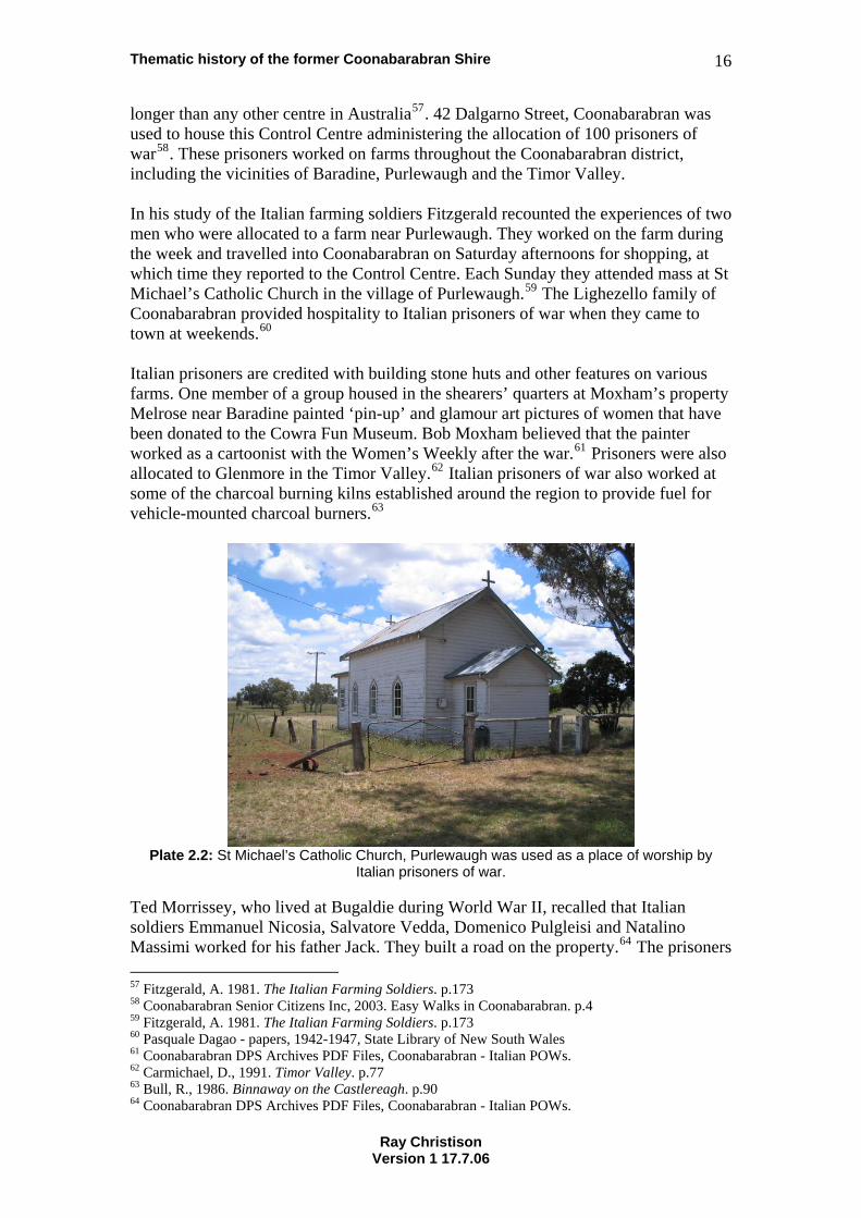
longer than any other centre in Australia57. 42 Dalgarno Street, Coonabarabran was used to house this Control Centre administering the allocation of 100 prisoners of war58. These prisoners worked on farms throughout the Coonabarabran district, including the vicinities of Baradine, Purlewaugh and the Timor Valley. In his study of the Italian farming soldiers Fitzgerald recounted the experiences of two men who were allocated to a farm near Purlewaugh. They worked on the farm during the week and travelled into Coonabarabran on Saturday afternoons for shopping, at which time they reported to the Control Centre. Each Sunday they attended mass at St Michael’s Catholic Church in the village of Purlewaugh.59 The Lighezello family of Coonabarabran provided hospitality to Italian prisoners of war when they came to town at weekends.60 Italian prisoners are credited with building stone huts and other features on various farms. One member of a group housed in the shearers’ quarters at Moxham’s property Melrose near Baradine painted ‘pin-up’ and glamour art pictures of women that have been donated to the Cowra Fun Museum. Bob Moxham believed that the painter worked as a cartoonist with the Women’s Weekly after the war.61 Prisoners were also allocated to Glenmore in the Timor Valley.62 Italian prisoners of war also worked at some of the charcoal burning kilns established around the region to provide fuel for vehicle-mounted charcoal burners.63
Plate 2.2: St Michael’s Catholic Church, Purlewaugh was used as a place of worship by
Italian prisoners of war.
Ted Morrissey, who lived at Bugaldie during World War II, recalled that Italian soldiers Emmanuel Nicosia, Salvatore Vedda, Domenico Pulgleisi and Natalino Massimi worked for his father Jack. They built a road on the property.64 The prisoners 57 Fitzgerald, A. 1981. The Italian Farming Soldiers. p.173 58 Coonabarabran Senior Citizens Inc, 2003. Easy Walks in Coonabarabran. p.4 59 Fitzgerald, A. 1981. The Italian Farming Soldiers. p.173 60 Pasquale Dagao - papers, 1942-1947, State Library of New South Wales 61 Coonabarabran DPS Archives PDF Files, Coonabarabran - Italian POWs. 62 Carmichael, D., 1991. Timor Valley. p.77 63 Bull, R., 1986. Binnaway on the Castlereagh. p.90 64 Coonabarabran DPS Archives PDF Files, Coonabarabran - Italian POWs.
Ray Christison Version 1 17.7.06
Thematic history of the former Coonabarabran Shire 17
of war developed close relationships with their employers and their families. In many cases links were maintained well after World War II ended. Ted also recounted his memories of the end of World War II:
On 15th August 1945 I had the four POWs over at Slippery Hill filling in bog holes with rocks when Bob my brother came over to tell us that the war was over and we stopped work. Then the Italians got a bit hard to handle, they wanted to go home straight away but first they wanted to be discharged in Australia. In January 1946 I took them to Coona Railway Station. They had a special train for POWs and what annoyed me was, when a bloke called Sgt. Tanner(?) … soon as my Italian friends got off the truck they were issued with orders cursin’ and swearin’ and told where to sit and Sgt Tanner had a six shooter in his hand , a big revolver and he said: “Which one of you bastards will make a run for it so I can take a shot at him?” I said: “Put the bloody thing away before you shoot yourself in the foot.” Agh Agh. Well I said: “Look, you’ve had stacks of time to go over to bloody New Guinea and have a go at the Japs. What was holdin’ you back?” Well he never said any more then. He walked away. I think he felt a bit self conscious and a bit over wrought, and the Italians were sent back to Cowra and didn’t leave ‘til October 1946.65
2.4 NSW Historical Theme: Migration The first migrations of Europeans into the Coonabarabran region occurred from the 1820s. Within a fairly short time of John Oxley’s first journey through the district in 1818 (refer Section 3.6 Exploration) squatters were moving mobs of sheep and cattle from the Liverpool Plains and the Bowenfels-Bathurst region. This movement is covered in Section 3.12 Pastoralism. Rolls notes that Biamble, James Walker’s main sheep station employed over 60 men and no women in 1839. Outstations of Biamble such as Goorianawa and Baradine were operated for years by two men.66 It appears that Chinese workers were present in the region from as early as the 1830s. Andrew Brown’s diaries noted that he was employing Chinese stockmen and labourers on the Castlereagh at this time67. The cessation of transportation of convicts in the 1840s created a shortage of cheap labour in New South Wales. This led to an increase in the ‘numbers of Chinese people arriving as indentured labourers to work as shepherds and irrigation experts’. It appears that all of these workers came from Fujian province. Some may have been kidnapped.68 A number of authors have also noted attempts to bring Indian workers into the area. Attempts were made from the 1840s to supplement a shortage of convict and free labour with workers brought in from India. By all accounts this experiment failed. Chinese workers were found to be more adaptable69. Andrew Brown continued to engage Chinese shepherds and hutkeepers during the labour shortages of the 1850s 65 Coonabarabran DPS, Ted Morrissey – memories of Coonabarabran. 66 Rolls, E., 1982. A Million Wild Acres. p.122 67 Wilton, J., 2004. Golden threads. p.11 68 Williams, M., 1999. Chinese Settlement in NSW a thematic history. p.4 69 Cain, M. 1923. ‘Coonabarabran in the ‘Sixties’. p.370
Ray Christison Version 1 17.7.06
Thematic history of the former Coonabarabran Shire 18
gold rushes70. Rolls records how Charles Taylor of Dinby used Chinese labourers in the 1880s to build a dam on Dinby Creek, ‘using picks, shovels and wheelbarrows’71. After the gold rush era great effort was put into clearing large tracts of land to foster pasture growth. Gangs of Chinese labourers were employed across the west to ringbark trees and carry out the three to four years of sucker bashing required to ensure no regrowth occurred. These gangs travelled from property to property, generally camping near a source of water.72 Restrictions on land ownership by immigrants from China encouraged their pursuit of opportunities not dependent upon access to land and established a long association with retail and commercial enterprise. This trend was reinforced by a narrowing of employment opportunities for Chinese people after 1901 that saw a ‘dramatic collapse of the NSW rural population in the early years of the 20th century’73. In the late 19th and early 20th centuries some Chinese migrants established ‘stores and other businesses to supply … customers throughout’ the colony74. The Woo family has operated commercial enterprises in Coonabarabran until the present time. In Binnaway Sun On traded as a vegetable gardener and store owner, selling this business to W. H. Guy in 1917. The Guy family continued to trade in Binnaway throughout the 20th century.75 Greek immigrants created another long held tradition in regional retailing. In 1916 there were reputed to be 625 Greek shops in Australia76. Greek cafes and fish shops are a legendary phenomenon throughout regional New South Wales. The former Boronia and Sunshine Cafes in Coonabarabran are remembered locally as two remnants of this phenomenon. The mid 19th century saw an exodus of people from German states affected by the conflict and famines of the 1840s and 1850s. A number of these emigrants came to Australia, many seeking out opportunities to establish vineyards and small farms. Jacob and Anna Veronica Halter established their property Winegarden at Gundi in the Timor Valley in 1873. Their grape growing efforts were apparently futile, yielding only sour wine.77 Wilhelm Opferkuch, stonemason, and his wife Christina selected land in the Binnaway district in the early 1870s. Opferkuch had come to the district to cut stone for David Innes Watt’s homestead at Ulinda and worked on the construction of the Coonabarabran Court House.78 Swiss born builder Albert Zimmerli arrived in the Binnaway district in the early 1920s, having lived in Australia since 1884. He was responsible for the construction
70 Rolls, E., 1982. A Million Wild Acres. p.155 71 Rolls, E., 1982. A Million Wild Acres. p.196 72 Buxton, G., 1967. The Riverina 1861-1891 An Australian Regional Study, pp.247-248 73 Williams, M., 1999. Chinese Settlement in NSW a thematic history. p.36 74 Williams, M., 1999. Chinese Settlement in NSW a thematic history. p.20 75 Bull, R., 1986. Binnaway on the Castlereagh. p.53 76 Turnbull, C. & Valiotis, C., 2001. ‘Beyond the Rolling Wave’ A thematic history of Greek settlement in New South Wales. p.19 77 Carmichael, D., 1991. Timor Valley. pp.34-35 78 Bull, R., 1986. Binnaway on the Castlereagh. p.14
Ray Christison Version 1 17.7.06
Thematic history of the former Coonabarabran Shire 19
of many buildings in the town and organised relief work for unemployed men during the Great Depression.79 The Anglo-Celtic population of the area grew after certainty was applied to land titles from the late 1830s and station owners began to move into the district with their families. As development and trade increased people moved from other parts of New South Wales. Moves towards closer settlement ensured that this inward movement of population continued well into the 1950s. Free selection and later soldier settlement saw people moving into the area from other farming areas that were undergoing rural restructuring. In his memoir of Darouble and Napier Albert Young noted that his family had moved from Victoria to the Curlewis area via the Riverina. This movement of people was an outcome of processes that had commenced after the 1850s gold rushes in Victoria. As the dynamic of the goldfields moved towards reef mining and employment was available for fewer people settlers had moved north, seeking land in the pastoral districts of New South Wales. Many of these people, taking advantage of the New South Wales Free Selection system were forced onto marginal lands within the colony. Young noted that the families who had moved to Curlewis later moved westwards to farm in the Ulamambri-Purlewaugh district. Musician Frank Bourke’s family followed the path of many itinerant workers, moving from place to place in search of work, until his mother demanded to settle in one place, that place being on a selection near Binnaway. Elva Shumack’s account of the development of Goolhi after World War II covers the immigration into the district of soldier settlers from many parts of rural New South Wales. Russell Bright’s account of his time on the railways also indicates that this enterprise brought people into the district from all over the state. The period after World War II saw new patterns of migration. Newly settled migrants from Europe moved into many regional areas and made their mark. Former Forest Foreman Buster Davies recalled European migrants who worked in the Pilliga forests after the war:
Many of these migrants were told, when they arrived in Sydney, that there was work in the forests out west. So they immediately caught a train and arrived in the Pilliga to begin work as soon as possible. They were good workers, but found the heat difficult to bear. People were tolerant and accepting of these migrants, especially the Poles, and Yugoslavs. Buster, however, found the ‘Ukrainians were hard to get along with’.80
Peter and Tryn Zordrager are notable among post-war migrants who made an impact on the region. They emigrated from the Netherlands in 1950, moving to Ulamambri and later Coonabarabran. After purchasing 40 acres of the W. E. Conn estate in the Timor Valley in 1970 the Zordragers established the Miniland tourism complex. Opened in 1972 this attraction received a number of national tourism awards ‘in
79 Bull, R., 1986. Binnaway on the Castlereagh. p.68 80 Curby, P. & Humphreys, A., 2002. Non-Indigenous Cultural Heritage Study. p.43
Ray Christison Version 1 17.7.06
Thematic history of the former Coonabarabran Shire 20
recognition of outstanding achievement in the development and promotion of tourism in NSW’.81 The post-war era also saw dramatic population movements within New South Wales. New infrastructure projects encouraged the movement of workers and established employers such as the railway complex at Binnaway ensured that trainees and other workers seeking career progression moved into the area. The demise of steam locomotion on the New South Wales railways and the gradual decline of rail services have been accompanied by reduced economic activity in the rail centre of Binnaway. Similarly ongoing downturns in the levels of labour required in the agricultural, pastoral and forestry industries have led to slow but inevitable reductions in the population of many outlying areas.
81 Carmichael, D., 1991. Timor Valley. pp.64-67
Ray Christison Version 1 17.7.06
Thematic history of the former Coonabarabran Shire 21
3. Australian Historical Theme: Developing local, regional and national economies While Geoffrey Blainey conceived of Australian history as dominated by ‘the tyranny of distance’ this concept is alien to Indigenous Australians. Eighteenth and 19th century developments in technology made it possible to link the continent to distant marketplaces, and the incentive for almost every expedition by the first European ‘explorers’ was the search for valuable resources. Much subsequent Australian history has revolved around the search for a staple on which to base regional economic development.82 3.1 NSW Historical Theme: Agriculture James Weston is credited as being the first agriculturalist in the Coonabarabran district. Weston was an ex-convict who had worked as a ploughman in England. He was assigned to Alexander Busby who held land at Cassilis. Weston and his wife Lucy lived in the Coolah/Cassilis area. Some time after being granted his freedom in 1843 he took over the Coolabarbyan run and began to undertake improvements. Among other things he started cultivating 20 acres of wheat on the southern bank of the Castlereagh River in the area now that now includes Neilson Park. Pickette and Campbell note that the scarcity of wheat in the outlying districts of the colony at that time would have ensured a premium price for his crops.83 The period 1860 to 1880 saw a movement of wheat growing away from the coastal areas of New South Wales to the inland. This resulted from the combination of closer settlement encouraged by the Robertson Land Acts and outbreaks of rust in coastal wheat crops.84 Ongoing government moves to develop closer settlement in the northwest of New South Wales were accompanied by efforts to encourage more wheat growing. Most early selectors tended to grow small acreages of wheat that provided flour for their own consumption. Any surplus could also be sold. Wheat was taken to Robert Neilson’s or McIntyre’s mills at Coonabarabran (refer to Section 3.10 Industry) for processing85. Farmers in the north western districts appear to have been slow to take up innovations in agricultural practice. The distance from commercial markets, difficulties with transport and the unavailability of suitable strains of wheat possibly worked as a disincentive to large-scale cultivation. Into the early 20th century farmers persisted with the ancient and difficult Scottish plough designs, crops were generally sown and harvested by hand, and wheat winnowed and threshed by teams of labourers.86 New technology was gradually introduced from other areas. American built McCormick horse-drawn harvesters were available in the late 19th century. A contractor at Binnaway had two of these and travelled the northwest working crops at harvest time. New, rust resistant varieties of wheat such as Federation were introduced at the beginning of the 20th century. These made farming more viable in
82 Australian Historic Themes Framework, 2001. 83 Pickette, J. & Campbell, M. 1983. Coonabarabran as it Was in the Beginning. pp.37 & 38 84 Godwin, L., 1983. The Life and Death of a Flourmill: McCrossin’s Mill, Uralla. pp.67 & 68 85 Rolls, E., 1982. A Million Wild Acres. p.211 86 Rolls, E., 1982. A Million Wild Acres. pp.211-213
Ray Christison Version 1 17.7.06
Thematic history of the former Coonabarabran Shire 22
the inland areas. Around 1908 the Australian built H. V. McKay & Co harvester was first demonstrated in Coonabarabran.87 These technological developments, and the coming of the railway from 1917, encouraged broader cultivation of wheat from early in the 20th century. Soldier settlement schemes and other ongoing closer settlement also encouraged increases in the cultivation of crops. Grain elevators were constructed along the railway lines of New South Wales from 192888. These structures facilitated the storage and transport of bulk quantities of cereals, gradually replacing the tedious and labour intensive processes of bagging wheat and other crops for transport. Despite this some farmers continued to bag wheat well into the 1960s89. Section 5.1 Labour contains further information about the handling of bagged wheat. Market gardens were established in a few locations on the banks of watercourses with a regular supply of water. Two Scotsmen grew vegetables near the Aloes in the Pilliga Forest and vegetables were also grown commercially at Bugaldie. Market gardens were also established for a brief period at Merebene. Chinese market gardens were established in Coonabarabran. The operators of these gardens drew water from the Castlereagh River by means of:
… a horse driven device of their own making… A wide endless belt of greased canvas with wooden slats nailed on at intervals ran under the water and up through a wooden channel.90
Vegetable gardening was not the exclusive domain of Chinese settlers. Conditions in a number of the river and creek valleys of the district proved to be quite suitable for vegetable growing and many selectors grew vegetables to supplement their incomes from other farming activities. Ted Morrissey recalled his father, Robert Morrissey’s decision to commence vegetable growing:
The moment of truth came for Dad in early 1923 when he was in the Australian Bank of Commerce to deposit two weeks’ rabbiting cheque for £10 when Bill Young, the Chinese market gardener came in to bank his takings for the week. He and Dad were friends. He told Dad he had £25 in cash to bank. Dad decided on the spot to try growing vegetables on the land his sister, Kathleen, had left to him.91
Robert Morrissey obtained seed from the Herbert J. Rumsey seed company92 and by 1939 he signed a seed-growing contract with the company93. During World War II the company formed a ‘vegetable seed committee’ with other seed merchants in Sydney to help overcome a vegetable seed shortage. Ted Morrissey recalled that in 1942 ‘the
87 Rolls, E., 1982. A Million Wild Acres. p.213-214 88 Ryan, K., 1990. Storing the Golden Grain. 89 Rolls, E., 1982. A Million Wild Acres. p.220 90 Rolls, E., 1982. A Million Wild Acres. p.298 91 Morrissey, Memories of Coonabarabran. p.11 92 Morrissey, Memories of Coonabarabran. p.11 93 Morrissey, Memories of Coonabarabran.
Ray Christison Version 1 17.7.06
Thematic history of the former Coonabarabran Shire 23
army came up and button-holed dad and told him to increase seed production. The army offered land army women to supplement his labour force. Instead he accepted an offer of Italian Prisoners of War ‘because of the lifting of a bushel and a half cases onto trucks.94 As in many other areas of Australia viticulture was first practiced in the Coonabarabran district by German immigrants. Frederick Liebentritt and his wife owned a vineyard on the Timor Road in the 1870s95. 3.2 NSW Historical Theme: Commerce The earliest commercial undertakings in the region appear to have been inns and hostelries. These were established at suitable points close to river crossings or on specific transport routes. On more popular transport routes these inns were often combined with general stores. William Field and James Weston developed such establishments on either side of the Castlereagh River in the 1840s. Weston’s Castlereagh Inn was ‘on the north side of Dalgarno Street, (mid way between John and Robertson Streets), Field’s (Traveller’s Home) just east of Nandi Mountain’96. In the days of horse transport facilities for blacksmiths, farriers and the repair of livery were as important as inns and general stores. Benjamin Plant established a smithy at a place near the Castlereagh Inn that later became the corner of Dalgarno and Robertson Streets97. These establishments marked the beginning of Coonabarabran. The first bank trading in Coonabarabran was the Australian Joint Stock Bank that opened a branch in the 1860s98. As the town grew William Field eventually transferred his licence from the Traveller’s Home to the Royal Hotel in Dalgarno Street99. Other establishments developed and new faces saw the opportunities presented by the brash frontier town. Robert Neilson moved to Coonabarabran in 1870, purchased the now defunct Castlereagh Inn in partnership with Thomas Cadell, and established a store that traded as Robert Neilson & Co. Neilson also established a steam flourmill (refer to Section 3.10 Industry).100 Robert Neilson & Co. grew to become one of the major business houses of the town. The company’s main premises were constructed in Dalgarno Street. These buildings were destroyed by fire in 1920 and the existing store built in their place101. Neilson became an active leader of the Coonabarabran community in the late 19th century (refer to Section 9.2 Persons). Jethro White was another retailer who prospered and became a prominent citizen. He moved to Coonabarabran in the 1860s to operate a branch of the Coonamble based A. Wilmott & Co. He eventually purchased the retail establishment and prospered102. In the 1880s he built a new brick store that is still in existence. Like Neilson his name
94 Morrissey, Memories of Coonabarabran. 95 Pickette, J. & Campbell, M. 1983. Coonabarabran as it Was in the Beginning. p.101 96 Pickette, J. & Campbell, M. 1983. Coonabarabran as it Was in the Beginning. pp.49-50 97 Pickette, J. & Campbell, M. 1983. Coonabarabran as it Was in the Beginning. p.52 98 Pickette, J. & Campbell, M. 1983. Coonabarabran as it Was in the Beginning. pp.98 & 101 99 Pickette, J. & Campbell, M. 1983. Coonabarabran as it Was in the Beginning. p.92 100 Pickette, J. & Campbell, M. 1983. Coonabarabran as it Was in the Beginning. pp.93-94 101 Pickette, J. & Campbell, M. 1983. Coonabarabran as it Was in the Beginning. p.111 102 Pickette, J. & Campbell, M. 1983. Coonabarabran as it Was in the Beginning. pp.80-81
Ray Christison Version 1 17.7.06
Thematic history of the former Coonabarabran Shire 24
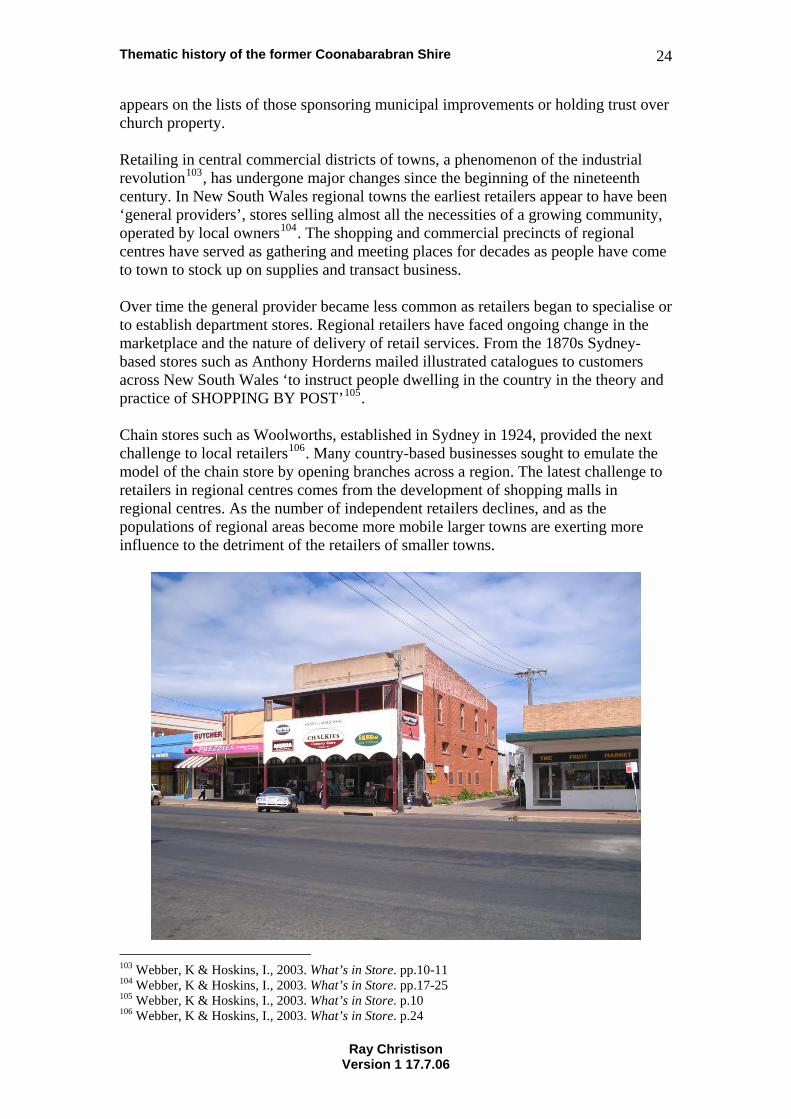
appears on the lists of those sponsoring municipal improvements or holding trust over church property. Retailing in central commercial districts of towns, a phenomenon of the industrial revolution103, has undergone major changes since the beginning of the nineteenth century. In New South Wales regional towns the earliest retailers appear to have been ‘general providers’, stores selling almost all the necessities of a growing community, operated by local owners104. The shopping and commercial precincts of regional centres have served as gathering and meeting places for decades as people have come to town to stock up on supplies and transact business. Over time the general provider became less common as retailers began to specialise or to establish department stores. Regional retailers have faced ongoing change in the marketplace and the nature of delivery of retail services. From the 1870s Sydney-based stores such as Anthony Horderns mailed illustrated catalogues to customers across New South Wales ‘to instruct people dwelling in the country in the theory and practice of SHOPPING BY POST’105. Chain stores such as Woolworths, established in Sydney in 1924, provided the next challenge to local retailers106. Many country-based businesses sought to emulate the model of the chain store by opening branches across a region. The latest challenge to retailers in regional centres comes from the development of shopping malls in regional centres. As the number of independent retailers declines, and as the populations of regional areas become more mobile larger towns are exerting more influence to the detriment of the retailers of smaller towns.
103 Webber, K & Hoskins, I., 2003. What’s in Store. pp.10-11 104 Webber, K & Hoskins, I., 2003. What’s in Store. pp.17-25 105 Webber, K & Hoskins, I., 2003. What’s in Store. p.10 106 Webber, K & Hoskins, I., 2003. What’s in Store. p.24
Ray Christison Version 1 17.7.06
Thematic history of the former Coonabarabran Shire 25
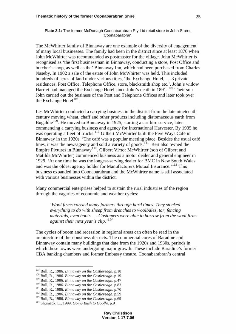
Plate 3.1: The former McDonagh Coonabarabran Pty Ltd retail store in John Street, Coonabarabran.
The McWhirter family of Binnaway are one example of the diversity of engagement of many local businesses. The family had been in the district since at least 1876 when John McWhirter was recommended as postmaster for the village. John McWhirter is recognised as ‘the first businessman in Binnaway, conducting a store, Post Office and butcher’s shop, as well as the’ Binnaway Inn, which had been purchased from Charles Naseby. In 1902 a sale of the estate of John McWhirter was held. This included hundreds of acres of land under various titles, ‘the Exchange Hotel, … 3 private residences, Post Office, Telephone Office, store, blacksmith shop etc.’. John’s widow Harriet had managed the Exchange Hotel since John’s death in 1891. 107 Their son John carried out the business of the Post and Telephone Offices and later took over the Exchange Hotel108. Les McWhirter conducted a carrying business in the district from the late nineteenth century moving wheat, chaff and other products including diatomaceous earth from Bugaldie109. He moved to Binnaway in 1925, starting a car-hire service, later commencing a carrying business and agency for International Harvester. By 1935 he was operating a fleet of trucks.110 Gilbert McWhirter built the Five Ways Café in Binnaway in the 1920s. ‘The café was a popular meeting place. Besides the usual café lines, it was the newsagency and sold a variety of goods.111 Bert also owned the Empire Pictures in Binnaway112. Gilbert Victor McWhirter (son of Gilbert and Matilda McWhirter) commenced business as a motor dealer and general engineer in 1929. ‘At one time he was the longest-serving dealer for BMC in New South Wales and was the oldest agency holder for Manufacturers Mutual Insurance.’113 This business expanded into Coonabarabran and the McWhirter name is still associated with various businesses within the district. Many commercial enterprises helped to sustain the rural industries of the region through the vagaries of economic and weather cycles:
‘Wool firms carried many farmers through hard times. They stocked everything to do with sheep from drenches to woolbales, tar, fencing materials, even boots. … Customers were able to borrow from the wool firms against their next year’s clip.’114
The cycles of boom and recession in regional areas can often be read in the architecture of their business districts. The commercial cores of Baradine and Binnaway contain many buildings that date from the 1920s and 1930s, periods in which these towns were undergoing major growth. These include Baradine’s former CBA banking chambers and former Embassy theatre. Coonabarabran’s central
107 Bull, R., 1986. Binnaway on the Castlereagh. p.18 108 Bull, R., 1986. Binnaway on the Castlereagh. p.19 109 Bull, R., 1986. Binnaway on the Castlereagh. p.47 110 Bull, R., 1986. Binnaway on the Castlereagh. p.83 111 Bull, R., 1986. Binnaway on the Castlereagh. p.70 112 Bull, R., 1986. Binnaway on the Castlereagh. p.59 113 Bull, R., 1986. Binnaway on the Castlereagh. p.69 114 Shumack, E., 1999. Going Bush to Goolhi. p.9
Ray Christison Version 1 17.7.06
Thematic history of the former Coonabarabran Shire 26
business district contains many commercial buildings that were constructed from the 1940s to the 1960s. In the early and mid 20th centuries many small landholders and pastoral workers supplemented their incomes by trapping rabbits and selling their pelts. Skin buyer’s shops were an important element of local economies. A wool hide and skin merchant operated in John Street Coonabarabran from a building on the site of the existing newsagency115. Ted Morrissey recalled his father gathering and selling rabbits, foxes, dead wool and horse’s tails to sell ‘to keep the pot boiling’116. 3.3 NSW Historical Theme: Communication The story of communication in the Coonabarabran district is tied to the developments that occurred in the technology of communications during the 19th and 20th centuries. Postal services were supplemented by telegraphic communication, then the introduction of telephone services and ongoing developments in electronic communication. At various times posts have been carried by horses, horse drawn coaches, trains and motor vehicles. In 1849 James Weston was appointed the first postmaster in the district. He conducted postal business from his inn. By 1861 David Cockburn was operating as postmaster from his house near the Castlereagh River crossing, having taken over from Campbell Pegus. Since 1856 Cockburn had operated a mail run to Wee Waa.117 On Cockburn’s death his wife, Julia, took over the post office and a mail contract from Coonabarabran to Gulligal118. Julia held this position until 1874 when she resigned after an adverse report from a postal inspector. Robert Neilson took over the postal duties until a new postmaster could be appointed.119 By the mid 1870s a telegraph line had been constructed from Coolah by way of Weetalibah, Box Ridge, Byrnong and Ulamambri. This line was still in use in the 1930s. In May 1875 the offices of Postmaster and Telegraph Master were combined. Fred Fowler from Coolah was appointed Telegraph Master and his wife Annie became Postmistress.120 In 1861 the first courthouse and lock up were constructed in weatherboard on the site of the present post office. After construction of the new stone courthouse in 1878 (refer to Section 7.3 Law and Order) the original courthouse was demolished and a post and telegraph office constructed in 1879. The first occupants of the new Post and Telegraph Office were Thomas Ryan and his wife Ellen who had come from Coonamble.121 Coach runs had been established from 1875 to connect to other towns in the region (refer Section 3.15 Transport) and carried mails as well as passengers. Their
115 Morrissey, John Street Coonabarabran 116 Morrissey, Memories of Coonabarabran. p.11 117 Pickette, J. & Campbell, M. 1983. Coonabarabran as it Was in the Beginning. p.62 118 Pickette, J. & Campbell, M. 1983. Coonabarabran as it Was in the Beginning. p.85 119 Pickette, J. & Campbell, M. 1983. Coonabarabran as it Was in the Beginning. p.99 120 Pickette, J. & Campbell, M. 1983. Coonabarabran as it Was in the Beginning. pp.99-100 121 Pickette, J. & Campbell, M. 1983. Coonabarabran as it Was in the Beginning. p.101
Ray Christison Version 1 17.7.06
Thematic history of the former Coonabarabran Shire 27
journeys started and ended at the post office. Three horseback mails continued to operate in the 1880s:
They went to Coolah by way of Binnaway, to Tambar Springs by Bradley’s at Baby Creek, Clay Holes and Saltwater Creek, and to Narrabri by Dandry, Sandbank, Yaminbah, Borah and Rocky Glen.122
Richard Henry Evans started publishing Coonabarabran’s first newspaper, the ‘Bligh Watchman’ in 1877. The newspaper was later sold to Kenneth Murchison, local auctioneer and commission agent.123 In 1910 Maurice Hennessy retired from teaching and established a second newspaper, the ‘Clarion’. He used the nom de plume of ‘Old Ned’ In 1927 the ‘Bligh Watchman’ and ‘Clarion’ were amalgamated to form the ‘Coonabarabran Times’.124 The newspaper maintains premises in Dalgarno Street. 3.4 NSW Historical Theme: Environment – Cultural landscape The environment of the area is described in Section 1.1 Environment – naturally evolved. The volcanic outcroppings of the Warrumbungle Mountains are one of the principal features impacting on the development of the cultural landscape of the former Coonabarabran Shire. This range and its extending ridges are the source of the Castlereagh River and many creeks whose presence have influenced the pattern of Aboriginal interactions with the land and European settlement. River and creek geography has influenced the placement and growth of the area’s principal towns and has also had a major impact on the density of settlement. The Warrumbungle ranges continue to impact on the economy of the region through the presence of the Warrumbungle National Park and the Siding Springs Observatory. Former volcanic activity has created unique places that have influenced the pattern of development of the region. Chalk mountain at Bugadlie is one of many unique natural features in the regional landscape. A large deposit of diatomaceous earth, or chalk, present near the top of the mountain was mined from the 1920s by Davis Gelatine. This deposit contains many fossilised fish and other marine creatures:
The site is the type locality for the fossil MACCULLOCHELLA MACQUARIENSIS (the Murray cod) which is known from only one other site in New South Wales (and there less abundantly). Sediments associated with the diatomite exhibit large scale sheared recumbent folds, believed to result from loading by subsequent lava flows.125
The unique nature of this place has led to its listing on the Register of the National Estate. The Pilliga forest is also a most prominent and influential feature of the cultural landscape of the Coonabarabran region. It is a landscape which represents the impact of various methods of human land management over thousands of years. Section 3.8 Forestry deals with the changes that have occurred in this forest since the coming of Europeans in the 1820s.
122 Pickette, J. & Campbell, M. 1983. Coonabarabran as it Was in the Beginning. p.118 123 Pickette, J. & Campbell, M. 1983. Coonabarabran as it Was in the Beginning. p.107 124 Pickette, J. & Campbell, M. 1983. Coonabarabran as it Was in the Beginning. p.125 125 Register of the National Estate Listing Place ID 451
Ray Christison Version 1 17.7.06
Thematic history of the former Coonabarabran Shire 28
Within the forest are cultural landscape features that have had their own impacts on life and behaviour in the region. These include the Salt Caves near Baradine which wee described by Rolls as follows:
One could walk thirty metres into the old caves. The salt hung in columns like stalactites from the roof. Wild horses, wild cattle, and kangaroos went there to lick it. Women from the Rocky Creek sawmill pulled off columns and took them away in bags for curing meat. Picnic parties began driving in by car in 1926. There was no road. They picked their way through the open forest. The caves collapsed during the 1930s and left no sign of salt.126
In other parts of the shire forestry, land clearing, pastoralism and agriculture have created landscapes of open pasture broken by ribbons of remnant bushland along waterways and the ridges and rocky places. 3.5 NSW Historical Theme: Events A number of grand memorials and numerous honour boards week to memorialise people from the district who have served their country in war. These include the handsome clock tower erected at the intersection of John and Dalgarno Streets in Coonabarabran and the Baradine Memorial Hall. Australia’s traumatic experience of Wold War I led to spontaneous community action to create memorials. Government regulation limited fundraising for the construction of memorials until after the end of hostilities in 1918. During and after the war there was much debate about the role of memorials. Public opinion was divided between the desirability of pure monument and the creation of memorials that served a civic purpose127. The utilitarian point of view seems to have prevailed in the Coonabarabran district with the erection of a memorial hall in Baradine in 1925 and a clock tower in Coonabarabran in 1926. The Baradine Memorial Hall was dedicated as the ‘Baradine and district Soldiers Memorial’ and the Coonabarabran memorial to ‘Perpetuate the memory of the men of the Coonabarabran District who served the Empire in the Great War’. The cessation of World War II saw the establishment government incentives that encouraged fundraising for utilitarian memorials. The post World War II period saw the extension of the Baradine Memorial Hall in 1953, ‘In memory of the men and women of this town and district who served in the Second World War’, and construction of swimming pool at Coonabarabran in the same year. The Coonabarabran swimming pool is dedicated to ‘those who served in war’. A memorial swimming pool was also constructed at Baradine ‘in memory of the men and women of Baradine district who paid the supreme sacrifice’. Honour rolls remembering those who served in both wars hang on the walls of community halls throughout the district. Other expressions of memory and gratitude exist in form of memorial plantings, including the Kurrajong tree and flagpole planted by the children of the Rocky Glen School as a memorial to former student Peter John Keay who was killed in action in 1943 while serving with the RAAF.
After World War II memorials throughout the country more readily acknowledged the service of women than had been the case after World War I. The memorials of the
126 Rolls, E., 1982. A Million Wild Acres. p.315 127 Inglis, K.S., 2001. Sacred Places: War Memorials in the Australian Landscape. pp.138-144
Ray Christison Version 1 17.7.06
Thematic history of the former Coonabarabran Shire 29
Coonabarabran district reflect this trend. More inclusive expressions of recognition of service are also present. The World War II honour roll from the former Long Ridge School, now located in the Purlewaugh Mechanics Institute Hall, includes the name of one local who served in the munitions industry.
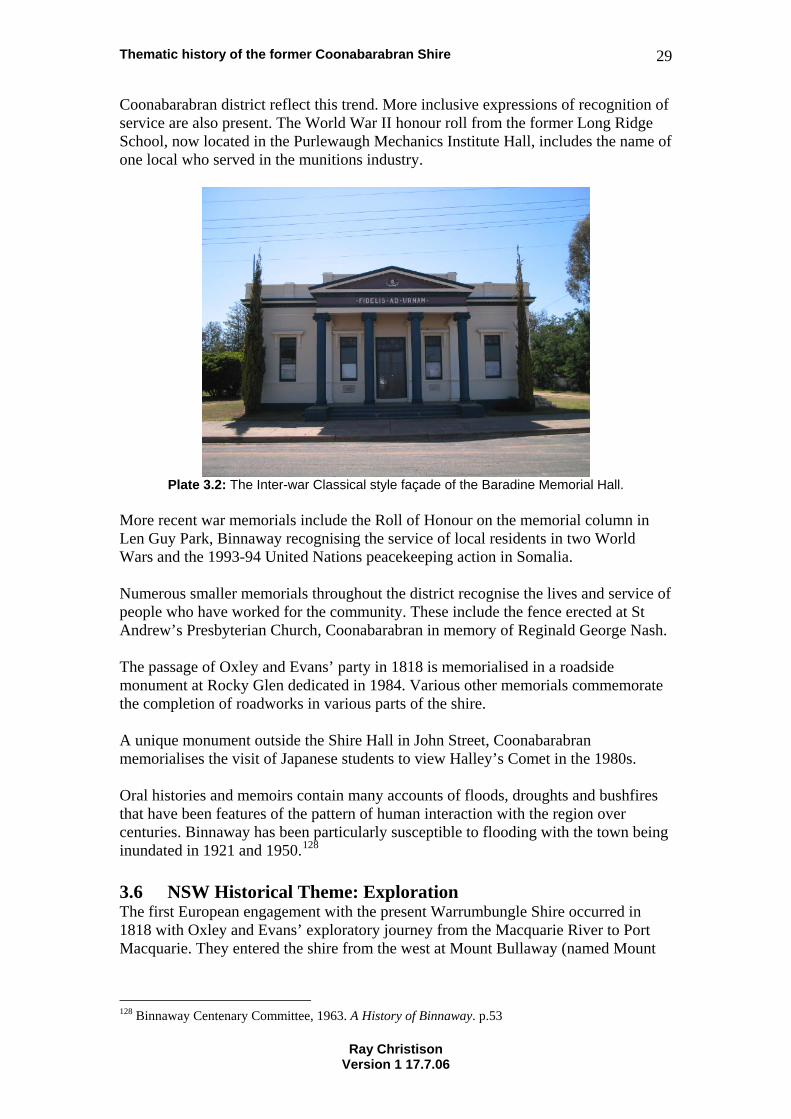
Plate 3.2: The Inter-war Classical style façade of the Baradine Memorial Hall.
More recent war memorials include the Roll of Honour on the memorial column in Len Guy Park, Binnaway recognising the service of local residents in two World Wars and the 1993-94 United Nations peacekeeping action in Somalia. Numerous smaller memorials throughout the district recognise the lives and service of people who have worked for the community. These include the fence erected at St Andrew’s Presbyterian Church, Coonabarabran in memory of Reginald George Nash. The passage of Oxley and Evans’ party in 1818 is memorialised in a roadside monument at Rocky Glen dedicated in 1984. Various other memorials commemorate the completion of roadworks in various parts of the shire. A unique monument outside the Shire Hall in John Street, Coonabarabran memorialises the visit of Japanese students to view Halley’s Comet in the 1980s. Oral histories and memoirs contain many accounts of floods, droughts and bushfires that have been features of the pattern of human interaction with the region over centuries. Binnaway has been particularly susceptible to flooding with the town being inundated in 1921 and 1950.128 3.6 NSW Historical Theme: Exploration The first European engagement with the present Warrumbungle Shire occurred in 1818 with Oxley and Evans’ exploratory journey from the Macquarie River to Port Macquarie. They entered the shire from the west at Mount Bullaway (named Mount
128 Binnaway Centenary Committee, 1963. A History of Binnaway. p.53
Ray Christison Version 1 17.7.06
Thematic history of the former Coonabarabran Shire 30
Exmouth by Oxley) on 8 August 1818129. From Mount Bullaway Oxley observed the Warrumbungle range that he named Arbuthnot’s Range. He also described the area covered by the current Pilliga Scrub130. Oxley’s group had a very difficult passage through the Goorianawa Valley and the area around Bugaldie in a very wet year. Their horses struggled and sank in the soft, sandy soils of the Pilliga. As they passed through the Pilliga to the north of the Warrumbungles the party travelled via Black Mountain, Goorianawa, Ulindi, Bugaldie Creek, Yearinan Creek, Dandry Creek, Yaminbah Creek, Borah Creek, Rocky Glen and Garrawilla. John Whitehead has identified various campsite locations used by Oxley and Evans’ party. A monument on the Oxley Highway near Rocky Glen commemorates their difficult journey and the route taken.131 This monument consists of a large slab of Pilliga sandstone ‘upstanding on a platform of Pilliga sandstone rocks topped by a layer of black magnetic rocks from Black Mt. … The magnetic rocks of Mt. Black … caused Oxley’s compass to deviate from correct NS reading”132. Oxley’s journey was followed up by the private exploratory journeys of a number of pastoralists and their agents. George Cox recorded viewing the Warrumbungles from the south in 1821133 and others began to explore north from Bathurst and Wallerawang and east from the Hunter Valley. The stories of these pastoralist explorers are covered in Section 3.12 Pastoralism. 3.7 NSW Historical Theme: Fishing Fishing has played a minor role in the story of the former Coonabarabran Shire. 3.8 NSW Historical Theme: Forestry The introduction of sheep and cattle into the Pilliga region in the 1830s, combined with accompanying disruption of the patterns of traditional Aboriginal land management, led to remarkable and unforseen consequences. When John Oxley moved through the Pilliga in 1818 he noted:
The appearance of the country passed over the most desolate and forbidding, but quite open, interspersed with miserable rocky crags, on which grew the cypress and eucalyptus. On the more level portions of the country a new and large species of eucalyptus and another of its genus (the iron bark) were the principal if not the only trees.134
Rolls described how sheep and cattle quickly ate out many grasses, changed the soil structure and soil chemistry. This, combined with the cessation of regular burning of the area by Aboriginal people and the displacement of the seed eating kangaroo rats, created the conditions for the re-colonisation of the savannah woodland by cypress and eucalyptus. Previous land management practices had confined these varieties to the shaggy ridges. ‘By the 1880s the Pilliga was a vast forest of pine, with ironbark 129 Whitehead, J. 2004. Tracking & Mapping the Explorers Vol. 2. p.170 130 Whitehead, J. 2004. Tracking & Mapping the Explorers Vol. 2. p.175 131 Whitehead, J. 2004. Tracking & Mapping the Explorers Vol. 2. pp.170-236 132 Coonabarabran DPS Archives PDF Files, Oxley Monument 133 Rolls, E., 1982. A Million Wild Acres. p.50 134 Whitehead, J., 2004. Tracking and Mapping the Explorers, Volume 2, p.191
Ray Christison Version 1 17.7.06
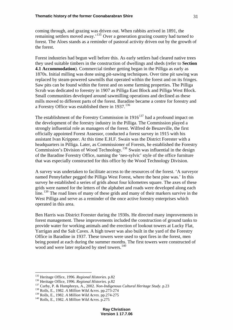
Thematic history of the former Coonabarabran Shire 31
coming through, and grazing was driven out. When rabbits arrived in 1891, the remaining settlers moved away.’135 Over a generation grazing country had turned to forest. The Aloes stands as a reminder of pastoral activity driven out by the growth of the forest. Forest industries had begun well before this. As early settlers had cleared native trees they used suitable timbers in the construction of dwellings and sheds (refer to Section 4.1 Accommodation). Commercial timber getting began in the Pilliga as early as 1870s. Initial milling was done using pit-sawing techniques. Over time pit sawing was replaced by steam-powered sawmills that operated within the forest and on its fringes. Saw pits can be found within the forest and on some farming properties. The Pilliga Scrub was dedicated to forestry in 1907 as Pilliga East Block and Pilliga West Block. Small communities developed around sawmilling operations and declined as these mills moved to different parts of the forest. Baradine became a centre for forestry and a Forestry Office was established there in 1937.136 The establishment of the Forestry Commission in 1916137 had a profound impact on the development of the forestry industry in the Pilliga. The Commission played a strongly influential role as managers of the forest. Wilfred de Beuzeville, the first officially appointed Forest Assessor, conducted a forest survey in 1915 with his assistant Ivan Krippner. At this time E.H.F. Swain was the District Forester with a headquarters in Pilliga. Later, as Commissioner of Forests, he established the Forestry Commission’s Division of Wood Technology.138 Swain was influential in the design of the Baradine Forestry Office, naming the ‘neo-sylvic’ style of the office furniture that was especially constructed for this office by the Wood Technology Division. A survey was undertaken to facilitate access to the resources of the forest. ‘A surveyor named Pennyfather pegged the Pilliga West Forest, where the best pine was.’ In this survey he established a series of grids about four kilometres square. The axes of these grids were named for the letters of the alphabet and roads were developed along each line.139 The road lines of many of these grids and many of their markers survive in the West Pilliga and serve as a reminder of the once active forestry enterprises which operated in this area. Ben Harris was District Forester during the 1930s. He directed many improvements in forest management. These improvements included the construction of ground tanks to provide water for working animals and the erection of lookout towers at Lucky Flat, Yarrigan and the Salt Caves. A high tower was also built in the yard of the Forestry Office in Baradine in 1937. These towers were used to spot fires in the forest, men being posted at each during the summer months. The first towers were constructed of wood and were later replaced by steel towers.140
135 Heritage Office, 1996. Regional Histories. p.82 136 Heritage Office, 1996. Regional Histories. p.82 137 Curby, P. & Humphreys, A., 2002. Non-Indigenous Cultural Heritage Study. p.23 138 Rolls, E., 1982. A Million Wild Acres. pp.273-274 139 Rolls, E., 1982. A Million Wild Acres. pp.274-275 140 Rolls, E., 1982. A Million Wild Acres. p.275
Ray Christison Version 1 17.7.06
Thematic history of the former Coonabarabran Shire 32
Plate 3.3: Yarrigan Fire Tower dominates the surrounding countryside.
Cypress was cut and milled for house frames, weatherboard cladding and floorboards whilst hardwoods were logged for railway sleepers, fence posts and bridge components. Products were railed out of Gwabegar, Kenebri, Baradine, Coonabarabran and Ulamambri. Sawmills established in the forest supported small but thriving communities. Wooleybah Sawmill sits within a village of houses built for its mill workers. The coming of the railway to the district in the early 20th century encouraged the development of sleeper cutting as a local industry. It was possible to make 12/- a day sleeper cutting at a time when farm labourers were receiving 6/- per day.141 Sleeper cutters lived a more transient existence, moving camps to access the hardwoods from which railway sleepers were fashioned. May Mead recalled the working conditions of members of her family who cut sleepers in the forest:
The men were sleeper cutters in those times and they used to cut sleepers up in the mountains and forest… They had to walk to find the ironbark trees so you were doin’ a lot of walkin’… They didn’t have much, the men, because sleeper cutters only get paid once a month. You had flour, sugar, tea, then you’d catch your own rabbits or goats or whatever for the meat part of it, and buy onions and potatoes which weren’t as dear as they are today. They’d set traps.142
The nature of sawmills and the transport of logs within the forest meant that these enterprises tended to relocate at various times. The machinery of Underwood’s large Rocky Creek sawmill moved closer to Kenebri to become the foundation of what is now known as Underwood’s mill, and the Milawindi Mill was moved by the Pinchams to Baradine. A series of severe bush fires finally drove many of the sawmills out of the forest in 1951. From that time logs were milled at sites on the fringes of the forest.143 141 Bull, R., 1986. Binnaway on the Castlereagh. p.58 142 Somerville, M. et al, 1994. The Sun Dancin’, People and Place in Coonabarabran. pp.131-132 143 Heritage Office, 1996. Regional Histories. p.82
Ray Christison Version 1 17.7.06
Thematic history of the former Coonabarabran Shire 33
Baradine, Kenebri and Gwabegar thrived on the trade generated by the forest industries. The railway to Gwabegar created a transport corridor through which supplies came into the forest communities and timber was transported out. General merchants in these places received a lot of business from the people who drew their living from the forest. There is little trace in the forest of the Rocky Creek mill and Euligal mill. Little remains of the Ceelnoy Mill on Ceelnoy Road. Surviving sawmill sites within the former Coonabarabran Shire include Pincham’s Mill at Baradine, Underwood’s Mill at Kenebri , Wooleybah Mill and Ceelnoy Mill. The log dump of Wangmann’s Mill near Kenebri is the only surviving evidence of the Wangmann family’s logging legacy. The magnificent interior of the Baradine Forestry Office testifies to the richness and quality of the timbers of the Pilliga Forests. 3.9 NSW Historical Theme: Health As with other services, colonial society depended largely on the family unit to provide medical care. Over centuries Aboriginal people had developed remedies to illnesses and injuries and the Europeans brought with them folk remedies from their countries of origin. There appeared to be some exchange of information and the application of the wisdom of different cultures to specific medical emergencies. The paper park and clay poultice applied by two Aboriginal women to the lacerated neck of Mrs Lovell at the Box Ridge Inn is a spectacular example of this. As the European occupation of the area consolidated formally trained medical practitioners moved into the region to provide health care. John Cockburn, Coonabarabran’s first doctor, was resident in the area in the 1850s144. He died in 1865 and his untrained wife carried on his work. In emergencies trained doctors were brought from as far away as Narrabri and Coonamble. In 1876 a Medical Guarantee Committee was established to secure the services of a doctor for Coonabarabran. Dr J. C. Souter established a practice in the town in 1879.145 Over time private hospitals were established in areas where population had consolidated. A private hospital was operated by Matron Smith in Dalgarno Street Coonabarabran in the late 1800s and the Gunyah Hospital on the south-east corner of John and Cassilis Streets operated well into the 20th century. Moves were made in the 1880s to establish a public hospital in Coonabarabran. Construction started in 1892 and the hospital opened in 1893.146 The hospital was opened on 6 April by Mrs J. McMaster who was presented the gold key used in the ceremony by Mrs Jethro White on behalf the hospital committee147. The hospital committee, comprised of prominent local residents, oversaw the operation of the establishment. By 1899 this committee was expressing concern about the lack of accommodation at the hospital for women. By 1921 the Hospital Board moved to allocate four beds in the Coonabarabran Hospital to local doctors for private patients. These patients were to pay £4/4/- per
144 Pickette, J. & Campbell, M. 1983. Coonabarabran as it Was in the Beginning. pp.55-56 145 Pickette, J & Campbell. M., 1983. Coonabarabran as it Was in the Beginning. pp.102-104 146 Pickette, J. & Campbell, M. 1983. Coonabarabran as it Was in the Beginning. p.139 147 Minutes of the Coonabarabran Hospital Board. 1893.
Ray Christison Version 1 17.7.06
Thematic history of the former Coonabarabran Shire 34
week. Patients in general wards payed £3/3/- per week and doctors’ fees for attendance in these wards was set at £80 per year.148 The hospital committee was later established as a Board to conduct the affairs of the Coonabarabran Hospital. This Board oversaw the planning and implementation of extensions to the Coonabarabran Hospital in 1935. These extensions were opened on 28 October 1935 by the Governor of New South Wales. A guard of honour was formed by local scouts and a civic reception held in the Council chambers afterwards.149 Hospital committees worked in other communities to establish public health facilities. In 1937 the community of Binnaway, fearing the loss of its town doctor, established a committee to develop a hospital. Plans for the proposed Binnaway hospital were considered by the Coonabarabran Hospital Board in 1938150 and the Binnaway Subsidiary Hospital was subsequently opened on 26 February 1941.151 The Coonabarabran Hospital Board also took control of the Baradine Hospital in February 1939152. This hospital had been constructed two years previously by the Country Women’s Association153. Further information relating to the role of the Country Women’s Association in improving health services in regional areas is contained in Section 8.5 Social Institutions. By 1951 the Coonabarabran District Hospital appears to have been in urgent need of renewal and extension. The Board moved in August that year to ask the local member of the Legislative Assembly, Jack Renshaw, to make representations regarding a new hospital to the Minister for Health. By this time the District Hospital was the only one operating in the town, was ‘out of date and likely to collapse’.154 Representations continued throughout the 1950s and 1960s. A planning committee for a new hospital was formed in 1971 and a new hospital was eventually opened in 1985.155 The Langley Private Hospital, operated by Nurse Taylor, was an institution in Coonabarabran for decades. Mary Ellen Taylor was one of seven children of Catherine Jane Taylor (nee Pearson) and Mark Taylor who farmed in the Bugaldie district during the late 19th century. She was born on 31 July 1883 and died on 3 April 1978. Philosophies of scientific parenting lead in the 20th century to an increasing amount of government involvement in teaching mothering skills and monitoring the health of babies. During the mid 20th century numerous baby health centres were established across New South Wales. In smaller communities these were often combined with other facilities. The Baradine CWA rooms were built in 1961 as a multi-function centre that included CWA facilities, women’s rest rooms and a baby health centre.
148 Minutes of the Coonabarabran Hospital Board. 1921 149 Minutes of the Coonabarabran Hospital Board. 1935. 150 Minutes of the Coonabarabran Hospital Board. 1938. 151 Bull, R., 1986. Binnaway on the Castlereagh. p.92 152 Minutes of the Coonabarabran Hospital Board. 1939. 153 Minutes of the Coonabarabran Hospital Board. 1938. 154 Minutes of the Coonabarabran Hospital Board. 1951. 155 Minutes of the Coonabarabran Hospital Board. 1951-1985
Ray Christison Version 1 17.7.06
Thematic history of the former Coonabarabran Shire 35
3.10 NSW Historical Theme: Industry The Coonabarabran district has hosted a number of industries which were directly linked to the pastoral and agricultural pursuits of the district. James Weston’s water powered flourmill was quite possibly the first industrial undertaking established in the district. This appears to have been constructed some time in the 1840s to mill the produce of Weston’s wheat fields. For most of the 19th century flour milling was the largest user of waterpower in the Australian colonies. New South Wales possessed a total of 45 such mills which operated at various times.156 Weston’s mill was overtaken by Robert Neilson and Thomas Cadell’s large steam driven flourmill which was located in John Street. The Town and Country Journal described the mill as follows:
… a prosaic square edifice with wall of weatherboard and roof of iron, with mysterious automats, named elevators; a grimy engineer, and a sad faced individual in spectacles, who calls himself ‘the miller’ … Within the roomy walls of the mill were stored large quantities of miscellaneous merchandise – chiefly ironmongery – the overflow of the general store of the firm. All and every newest invention connected with the machinery of the mills has been availed of, and the way in which these marvellous automats, the elevators, pick up, transfer, shake, silk dress, sift, separate, and finally lodge in the ultimate flour-bag of commerce, the imprisoned and perhaps passively astonished wheat, makes one think of a benevolent Troll or strange enchanter lost from Arabian Night-land.157
Many flour mills in New South Wales were driven out of business by supplies of cheaper South Australian milled flour from the 1880s onwards. The expansion of the railway network tended to facilitate the movement of cheaper imports into many areas of the colony. In many cases this tended to drive local industrial undertakings into bankruptcy and caused a restructuring of local economies. The relatively late arrival of the railway into the Coonabarabran Shire meant that this impact was somewhat diminished. Nielson’s mill was modernised with roller milling technology in the late 19th century and still operating well after World War I.158 Other flour mills operated in Coonabarabran. The Mcintyre family constructed a large flour mill adjacent to the railway line in the early 1920s. This large corrugated iron clad structure was destroyed by fire in 1928.159 P. J. Garland operated a cordial factory in Coonabarabran until 1899 when it was sold.160 The buildings of a Clare’s cordial factory are evident in King Street, between Charles and Cowper Streets. After World War II Coonabarabran Shire Council investigated the establishment of a brickworks in the town161. The railway also had a positive impact on the development of industry in the region. During the 1920s a freezing works was established in Coonabarabran by the Lachlan
156 Pearson, W., 1997. Water-Powered Flourmills in 19th-Century Tasmania. pp. 67 & 68 157 Pickette, J. & Campbell, M. 1983. Coonabarabran as it Was in the Beginning. p.94 158 Coonabarabran DPS Books & Documents, McIntyre’s Flour Mill 159 Coonabarabran DPS Books & Documents, McIntyre’s Flour Mill 160 Pickette, J. & Campbell, M. 1983. Coonabarabran as it Was in the Beginning. p.150 161 Minutes of Ordinary Meeting of Coonabarabran Shire Council, 15 November 1950
Ray Christison Version 1 17.7.06
Thematic history of the former Coonabarabran Shire 36
Ltd. Freezing Co.162 This was located on land at the corner of Essex and Cowper Streets serviced by a siding from the railway yards and was used for at least part of its operational life to freeze rabbits. A turkey freezing works was also established near the railway at Coonabarabran by Bill Hadfield who had a turkey farm at Willarene.163 The rabbit plague of the 1890s led to the establishment of freezing works around the district. Binnaway Freezing Works, a branch of Curtis and Curtis, ‘could handle at least 3,000 pairs of rabbits’. This complex operated until 1946. Freezing works such as this also supplied ice for residential and commercial use. 164 Other industries of the district have included the substantial timber milling industries of the Baradine and Kenebri districts. The story of these undertakings is covered in Section 3.8 Forestry. 3.11 NSW Historical Theme: Mining Aboriginal people were engaged in mining for centuries before the European occupation of Australia. Minerals were extracted to make stone tools and in some places ochres and clays were also mined. Minerals commonly used for toolmaking were quartz, silcrete, flint, obsidian, chalcedony and quartzite165. Many of these minerals were traded long distances. The presence of silcrete deposits in the Warrumbungle Ranges was noted by geologist G. H Dury in his 1969 study of volcanic crusts166. Given the geology of the region it is anticipated that mining of siliceous materials would have occurred in a number of places. The Coonabarabran area has experienced very little mining activity since European settlement. One quite unusual mining enterprise was established in the 1920s by Davis Gelatine167. This company reclaimed diatomaceous earth from a site near the top of Rundle Mountain near Bugaldie. Diatomaceous earth ‘is the remaining deposit of algae and water animals that lived in a hot warm body of water such as a lake which existed during the volcanic activities in the creation of the Warrumbungle Volcanic Shield’. It was used in the chemical industry and in swimming pool filters.168 Some quarrying activity has been undertaken around Coonabarabran with quarries operating at various times at the western end of Dalgarno Street, on the riverbank near the northern end of Cowper Street and in other parts of the town.169 3.12 NSW Historical Theme: Pastoralism The 1820s and 1830s in New South Wales were characterised by a push for new grazing lands beyond the Limit of Location established by Governor Darling. This was largely driven by growth in the colonial economy and increasing trade with Britain. The discovery of easy passes over the Liverpool ranges opened paths for squatters to move mobs of cattle and sheep into the rich Liverpool Plans. As these 162 Wallace, I., 1992. To Coonabarabran & Return. pp. 30 & 51 163 Information provided by Coonabarabran DPS 164 Bull, R., 1986. Binnaway on the Castlereagh. p.78 165 Mulvaney, J. & Kamminga, J., 1999. Prehistory of Australia, pp.213-214 166 Langford-Smith, T., 1978. Silcrete in Australia, p.9 167 Rolls, E., 1982. A Million Wild Acres. p.332 168 Whitehead, J., 2004. Tracking & Mapping the Explorers Vol.2. p.186 169 Local Government Dept of, (undated). Town of Coonabarabran – map.
Ray Christison Version 1 17.7.06
Thematic history of the former Coonabarabran Shire 37
groups were moving out of the Hunter Valley others were moving livestock north-west from the Lithgow and Bathurst regions to establish runs along the Castlereagh. Andrew Brown of Cooerwull, Bowenfels (at the western end of the Lithgow valley) is credited to be the first European to squat on the Castlereagh River. Brown spent the years around 1830 scouting runs for himself and his employer, James Walker of Wallerawong. Around the same time squatters such as the Cox brothers, Rouse brothers and representatives of William Lawson’s extended family were moving into the region from the east and south170. Other early squatters in the region included Sir John Jamison171 who, in a move similar to Brown and Walker, used grazing lands along the Namoi and in the Pilliga to fatten sheep and cattle. Brown, Walker and Jamison’s sheep were driven to their properties at Bowenfels, Wallerawang and Capertee for shearing each year. It was easier in those times to move living animals than dead loads of wool. When Charles Darwin visited the Wallerawong in 1836 he noted that:
The sheep were some 15,000 in number, of which the greater part were feeding under the care of different shepherds, on unoccupied ground, at the distance of more than a hundred miles, and beyond the limits of the colony.172
From 1833 early settlers in the Liverpool Plains region were pushed further north and westward after appropriation of substantial landholdings by the government supported Australian Agricultural Company173. During this period squatters were displaced and herds moved through newly discovered country in a game which Rolls described as having:
… rules more complicated than chess. And it was a rough game that extended outside the law of the land and often outside any moral laws. But few men stayed on the board for long. Flood, drought, depression, land laws kept bumping the board and many slid off.174
William Cox took up holdings at Nombi. Charles Purcell established his run Girriwillie (now Garawilla) north-east of the present day Coonabarabran. George Druitt, whose principal landholding was in Sydney’s Cumberland Plain, grazed sheep and cattle along Yaminba and Borah Creeks in the Pilliga. Edward Cox “formed adjacent sheep stations, Urabribble and Ulamanbri just east of the present Coonabarabran.”175 To the east of Cox’s holdings James Hale, an ex-convict who appears to have prospered under the patronage of William Cox and Sir John Jamison, took up runs at Tarawinda, immediately to the east of Ulamambri, Booballa (later Uliman) Bomera.
170 Rolls, E., 1982. A Million Wild Acres. p.83 171 Rolls, E., 1982. A Million Wild Acres. p.103 172 Darwin, C., A Journey to Bathurst in January, 1836. p.42 173 Rolls, E., 1982. A Million Wild Acres. pp.100-101 174 Rolls, E. 1982. A Million Wild Acres. p.65 175 Rolls, E., 1982. A Million Wild Acres. pp.107-109
Ray Christison Version 1 17.7.06
Thematic history of the former Coonabarabran Shire 38
Hale was apparently one of the first to apply for a licence to depasture stock beyond the limits of the colony in 1837.176 Pickette and Campbell gave the following account of Hale’s life:
Hale was born in Monmouth, England in 1795. At the age of twenty he was sentenced to seven years transportation for stealing goods from a parson. He arrived on the ‘Manner’ in 1816. After obtaining his ticket of leave, he worked for William Cox as an overseer… He became a successful and respected contractor to the Government for the supply of stores, firewood and cartage for the local survey parties at Windsor. Already he had 60 acres of land. Within three years he increased his holding to 2,000 acres.177
The general pattern of these early incursions into the region appears to have involved the identification of suitable pastures and the movement of cattle or sheep into the areas identified. Convict labourers, indentured servants or employees were left in small groups in isolated situations to tend the herds and flocks. By all accounts they generally lived in miserable circumstances deprived of decent food and in constant fear of attacks by Gamilaraay groups or bushrangers who had moved beyond the reach of the law. Governor Brisbane’s mounted police kept some order, although often squatters and their servants took the law into their own hands. A few punitive military expeditions had been mounted on the fringes of the region to establish the rule of British law. These had included Morisset’s expedition against the Wiradjuri around Mudgee and the upper Macquarie in 1824 and Nunn’s 1836 military expedition to the Gwydir and Namoi178. Policing of the frontier was taken over in the 1830s by the feared and hated Border Police. (Refer to Section 2.1 Aboriginal cultures and interactions with other cultures) In 1836 Governor Bourke established regulations which legalised squatting beyond the limits of the Nineteen Counties179. The ensuing period, which coincided with the height of the economic boom of the 1830s, saw the consolidation of many landholdings around the Castlereagh and Pilliga. During 1836-1837 the Coxes established a station, Cooleburebarun, on the Castlereagh. This later became Coonabarabran. Sydney merchant J.B. Bettington expanded his holdings down Teridgerie Creek on the northern side of the Warrumbungles. Here he established Teredgere. Andrew Brown extended his and James Walker’s holdings, finding a long waterhole on Baradine Creek he established Barradean and also Curianawa in the Goorianawa valley. They had previously established properties between the Warrumbungles and the site of Mendooran. These were Briambil and Cuigan. From 1834, with the assistance of James Walker’s nephew David Archer, and the guidance of the local Aboriginal people, Andrew Brown explored around and beyond the Warrumbungles, establishing stations on the watering
176 Cameron, R. The Little Town with the Big Heart. p.97 177 Pickette, J. & Campbell, M. 1983. Coonabarabran as it Was in the Beginning. p.25 178 Connor, J., 2002. The Australian Frontier Wars 1788-1838. pp. 59-61, 102-112 179 Morrisey, S. 1978, ‘The Pastoral Economy 1821-1850’. p.59
Ray Christison Version 1 17.7.06
Thematic history of the former Coonabarabran Shire 39
points of Yarragrin, Gundy, Bidden, Mogie Melon, Wallumburawang, Tooraweenah and Nullen.180 The economic downturn of the early 1840s impacted hard on pastoral runs at the fringes of settlement. Many squatters suffered severe losses and the pastoral industry was generally saved by the wholesale slaughter and boiling down of livestock. Their reduced fats were sold to Britain at a higher value than that of the animals’ meat, hides or fleeces. Increases in the price of wool in the late 1840s led to changes in land use and an increasing rise to dominance by sheep farming in the west of New South Wales. The fortunes of pastoralists were given an additional boost by the gold rushes of the early 1850s, which created an increase in demand for meat, and the American Civil War (1860-1864), which increased the English textile mills demand for wool. The gold rushes also led to shortages of labour on pastoral runs. Despite attempts to establish closer settlement in the late 19th century much of the region around Coonabarabran continued to be characterised by large cattle and sheep runs. Droughts, floods and adverse market conditions combined to drive many smaller and more marginal property holders off the land. According to Rolls:
By 1884 … the Pilliga forest area was encircled and engulfed by eight big holdings. Gholendaadi on the east had swallowed up Namoi Hut and Henriendi … it stretched down Coxs Creek from the present village of Mullaley to the Namoi, took in the towns of Boggabri, and joined Baan Baa south opposite the junction of Maules Creek and the Namoi… On the south Girriwillie and Nombi had run together as Garawilla, a rich property. Selectors had begun to come on to Goorianawa which had not extended though it was still one of the biggest holdings. On the west of Goorianawa, old Teridgerie had combined with several other runs and become the lovely Calga of the Ryder brothers… South of the travelling stock route between Coonamble and Baradine three runs only extended the seventy kilometres between the Castlereagh River and Baradine Creek, Warrena, Calga and Goorianawa, and north of the stock route three other runs extended the distance, Nebea, Urawilkie and Charles Colwell’s Bimble. On the central part of Baradine Creek, Mrs Catherine MacKenzie’s Wangen sprawled over fifty thousand hectares of Wangen, Wangen Back, Bulluwi and Erinbri.181
The second half of the 19th Century was also characterised by the encroachment of the Pilliga Forest into lands which had previously been used for grazing. By 1870 the acacia and cypress trees of the Pilliga had begun to invade land which had been used for grazing since the 1830s.
180 Rolls, E., 1982. A Million Wild Acres. pp.116-119 181 Rolls, E., 1982. A Million Wild Acres. pp.188-189
Ray Christison Version 1 17.7.06
Thematic history of the former Coonabarabran Shire 40
During the 19th century a network of travelling stock routes was established to facilitate the movement of stock around the colony. In many places stock routes traversed pastoral holdings. As stock was moved along these routes landholders had to be warned 24 hours in advance that stock would cross their boundaries.
This notice had to be given by hand, so that he could have time to shift his stock off the route and avoid getting them mixed up with the travelling mob. This was known as ‘boxing up.’ If this happened, the stock would have to be taken to the nearest yards and drafted out, and this might take several days. If the fault was with the drover he would have to pay the cost of drafting…182
The last two decades of the 19th century saw the movement of settlers into country that had been ignored by the earlier pastoralists. Allan Young noted that large stations were formed on the black soil plains of the Curlewis region to run sheep and cattle. The early settlers ignored the heavily timbered red soil country. Eventually farmers from Victoria and southern New South Wales bought blocks of previously unimproved land ‘very cheap’. Some of the land around Purlewaugh was subdivided for soldier settlers after World War I. 183 Ned Doel’s Ulan and Mary Rogers’ Napier were sold for soldier settler development around 1921184, and Ulamamabri station was subdivided in 1926.185 The fortunes of most post World War II soldier settlers in the region were supported by the wool boom of the 1950s. Demand for wool, partly created by the Korean War, encouraged wool agents to advance credit for purchase of much needed equipment to these settlers who were in many cases ‘as free of money as a frog is of feathers’ and lacking security to arrange bank loans.186 The 20th century saw substantial changes in land management practices and pastoralism. The wool boom of the 1950s saw substantial investment in many rural properties with homesteads and woolsheds being modernised, modified or replaced. Closer settlement reduced the viability of many of the larger homestead and woolshed complexes.187 The wool crisis of the 1970s and subsequent problems in the wool industry led to the abandonment of wool growing on many properties and a re-emergence of cattle raising as the principal pastoral industry of the region. Woolsheds such as Uliman and Bomera have not seen shearing since the 1970s. The farming of sheep and cattle continue to be major contributors to the economy of the region. Many stations contain the infrastructure of a pastoral industry that has developed over a period of 180 years. These include Bomera, Uliman, Oakleigh, Goorianawa, and the shearing shed at Pilton.
182 Tritton, H.P. (Duke). 1964. Time Means Tucker. p.26 183 Young, A., 1992. From the top of the hill. p.8 184 Young, A., 1992. From the top of the hill. pp.6&23 185 Young, A., 1992. From the top of the hill. p.17 186 Shumack, E., 1999. Going Bush to Goolhi. P.10 187 Sowden, H., 1972. Australian Woolsheds. p.29
Ray Christison Version 1 17.7.06
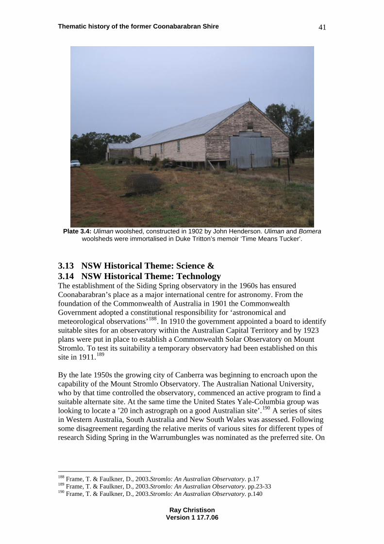
Thematic history of the former Coonabarabran Shire 41
Plate 3.4: Uliman woolshed, constructed in 1902 by John Henderson. Uliman and Bomera
woolsheds were immortalised in Duke Tritton’s memoir ‘Time Means Tucker’.
3.13 NSW Historical Theme: Science & 3.14 NSW Historical Theme: Technology The establishment of the Siding Spring observatory in the 1960s has ensured Coonabarabran’s place as a major international centre for astronomy. From the foundation of the Commonwealth of Australia in 1901 the Commonwealth Government adopted a constitutional responsibility for ‘astronomical and meteorological observations’188. In 1910 the government appointed a board to identify suitable sites for an observatory within the Australian Capital Territory and by 1923 plans were put in place to establish a Commonwealth Solar Observatory on Mount Stromlo. To test its suitability a temporary observatory had been established on this site in 1911.189 By the late 1950s the growing city of Canberra was beginning to encroach upon the capability of the Mount Stromlo Observatory. The Australian National University, who by that time controlled the observatory, commenced an active program to find a suitable alternate site. At the same time the United States Yale-Columbia group was looking to locate a ’20 inch astrograph on a good Australian site’.190 A series of sites in Western Australia, South Australia and New South Wales was assessed. Following some disagreement regarding the relative merits of various sites for different types of research Siding Spring in the Warrumbungles was nominated as the preferred site. On
188 Frame, T. & Faulkner, D., 2003.Stromlo: An Australian Observatory. p.17 189 Frame, T. & Faulkner, D., 2003.Stromlo: An Australian Observatory. pp.23-33 190 Frame, T. & Faulkner, D., 2003.Stromlo: An Australian Observatory. p.140
Ray Christison Version 1 17.7.06
Thematic history of the former Coonabarabran Shire 42
12 May 1962 ANU Vice-Chancellor Leonard Huxley announced that Siding Spring would become the observatory’s (Mount Stromlo’s) permanent field station.191 During 1965-66 a 40-inch reflector telescope and a 16-inch reflector telescope were installed at Siding Spring. These were followed by ‘a 24-inch instrument with a rotatable tube to facilitate polarisation observations’.192 The observatory has continued to be upgraded. In 1981, in response to the increase of light pollution around Mount Stromlo, the ANU moved the Uppsala Schmidt Camera to Siding Spring193. Frame and Faulkner summarised the development of Siding Spring as follows:
At the time it was not apparent just how important this decision would become in the development of Australian astronomy. It was expected that, although Siding Spring was to serve the ANU’s field station needs, continued Australia-wide testing would probably locate a better site for the eventual development of a very large reflector. In the event it was decided to build an Anglo-Australian 150-inch reflector at Siding Spring, followed by a British 48-inch Schmidt camera. With the further construction there of the ANU’s 2.3-metre Advanced Technology Telescope, and the transfer of the Uppsala Schmidt, Siding Spring Observatory has become one of the foremost international optical observatories in the world.194
The Anglo-Australian Observatory is funded equally by the British and Australian Governments. It was founded after representations to the Australian and British Governments in the 1960s, formal agreements to construct a large optical telescope being established in 1971. Construction of the Anglo-Australian Telescope commenced in 1972 and it was opened by His Royal Highness Prince Charles on 16 October 1974. The Anglo-Australian Observatory has pioneered the use of optical fibres in astronomy and currently leads the world in this work.195
The Anglo Australian Telescope is one of the most precise telescopes in the world, and astronomers use it to study the faintest and most distant objects in the Universe. The AAT has a mirror 3.9 m in diameter, the largest in Australia. Its excellent optics, combined with its state-of-the-art instrumentation and detectors puts it in the forefront of astronomical research.196
In addition to the world famous 3.9 metre Anglo Australian Telescope the Anglo Australian Observatory hosts the UK Schmidt Telescope. This is a specialised telescope with a very wide field of view. Telescopes of this type have been used since the installation of the first Schmidt telescope on Mount Palomar, USA in the 1950s to carry out complete photographic surveys of large sections of sky. When the Anglo Australian Telescope was being developed it was decided to install a Schmidt
191 Frame, T. & Faulkner, D., 2003.Stromlo: An Australian Observatory. pp.141-143 192 Frame, T. & Faulkner, D., 2003.Stromlo: An Australian Observatory. p.144 193 Frame, T. & Faulkner, D., 2003.Stromlo: An Australian Observatory. p.204 194 Frame, T. & Faulkner, D., 2003.Stromlo: An Australian Observatory. p.144 195 Anglo Australian Observatory [Online] 196 Anglo Australian Observatory 1999.
Ray Christison Version 1 17.7.06
Thematic history of the former Coonabarabran Shire 43
telescope at Siding Spring. The telescope was constructed under the direction of the Royal Observatory Edinburgh (ROE) and was formally opened in August 1973. It commenced service on 3 September that year. In 1988 the telescope officially became part of the Anglo Australian Observatory. The UK Schmidt Telescope has undertaken a major photographic survey of the southern sky.197
… the resulting Atlas has been distributed to some 170 institutions around the world. This atlas is now also widely available in digital form. The UK Schmidt also carried out a photographic near infrared survey of the Milky Way which has been widely distributed as an atlas made in the ROE Photolabs, and a new atlas of the equatorial strip of sky is now being produced. 198
The Anglo Australian Observatory is one of the foremost observatories in the world and has been responsible for a number of advances in modern astronomy. It is used by scientists from all over the world. ‘Competition for time on the telescope is intense, and only the projects with the most valuable scientific content are allocated time.’199 Following the destruction of the Mount Stromlo Observatory in the January 2003 bushfires Siding Spring became the ANU’s principal centre of astronomical research200. 3.15 NSW Historical Theme: Transport The earliest transport in the region was on foot. The Aboriginal people moved about this way, as did the early shepherds who moved at the same pace as the sheep they cared for. European settlers brought the horse and bullock drays or horse drawn wagons for heavy transport. As settlement developed in the area horse tracks developed. Some of these later developed into roads for heavier vehicles. Early road routes tended to follow the lines of creeks and rivers, and the easier passes over ridgelines. By the 1860s a series of wool roads and tracks connected Coonabarabran to Coonamble, Mendooran, Maitland, Quirindi, Mullaley and Wee Waa201. In his memoir, Time Means Tucker, Duke Tritton, renowned swaggie, shearer and bush balladist, described the work of the bullocky. He noted two Coonabarabran region bullockies who were working in the early 20th century. Ned Inglis of Baradine, aged almost 70 in 1905, had been driving bullocks all of his adult life. Before the railway was constructed over the Blue Mountains in the 1860s he had carted ‘wool from Tondeburine to Circular Quay. His father had two teams and Ned at fifteen was driving one’202. While fencing the boundary between Gumin and Goorianawa Tritton met Billy Harlow, ‘a professor in the art of bullock driving’203. He described how Harlow cared for his bullocks and how he drove his teams.
He never used a whip though he had one tied under the dray, and seldom spoke to his team above a normal voice. If he got into a tight place he would
197 UK Schmidt Telescope [Online] 198 UK Schmidt Telescope [Online] 199 Anglo Australian Observatory 1999. 200 Frame, T. & Faulkner, D., 2003.Stromlo: An Australian Observatory. p.275 201 Pickette, J. & Campbell, M. 1983. Coonabarabran as it Was in the Beginning. pp.42-43 202 Tritton, H.P. (Duke). 1964. Time Means Tucker. p.68 203 Tritton, H.P. (Duke). 1964. Time Means Tucker. p.55
Ray Christison Version 1 17.7.06
Thematic history of the former Coonabarabran Shire 44
say in a reproving manner, “Well, what a useless lot of cows a man’s stuck with,” straighten them up and say, “Now then, you blanky blankards, show us what you can do.” And I never saw them let him down.204
Tritton noted that ‘poor, patient bullocks … played a mighty part in making Australia a good place to live in’205. Bullock teams handled bulk transportation around the country well into the 20th century. Tritton, who spent years on the roads in the early 20th century, also recounted a journey between shearings at two woolsheds by a group of shearers:
Dave had a sulky and Jack a bicycle and both had pens at Guntawang. … So we put all the swags in the sulky and I rode with Dave. Jack rode the bike a few miles then leaned it against a tree and started walking. Dutchy ran behind the sulky till he came to the bike. Then he mounted it and rode past Jack. When he caught him up he got in the sulky and I ran behind, till we came to the bike. Then Jack took over and the performance was repeated. This method of travelling was used a lot in the bush. Two men with one bike could do fifty miles a day without much trouble.206
A weekly mail service to Mendooran was established in 1875. In that year Thomas Cheshire of Mudgee was granted a contract to carry mail in a two or three horse coach. This coach travelled via Luckey’s, Caigan, Mobla and Belar to Mendooran. Cobb & Co. bought out Cheshire’s contract in 1876.207 Robert Nowland commenced a coach service to Gunnedah via Garrawilla, Goolhi and Ghoolendaddy. Nowlandcontinued to use this route after the construction of a new road through Rocky Glen and Mullaley in 1880. By 1882 he had diverted his coach service to the new road.
208 As late as the 1870s the roads of the district were still being referred to as ‘bush tracks’. A programme of government road building resulted in improvements in the condition of roads and the creation of new road routes. These included the new road to Gunnedah referred to above and a road via Warkton and Merrygoen to Mendooran. A road bridge, constructed over the Castlereagh River in 1885, created an all weather crossing. The main route to Coolah was via Purlewaugh Road. The road gangs employed to construct and maintain these roads helped to expand the population of the district.209 As railways snaked out across the colony from the 1850s onwards they both revolutionised and supplanted earlier transport options. Coaching lines modified routes and opened new routes to adjust to the development of new rail termini. Coach operators appear to have been keen to establish routes to railheads developed under the ambitious 1879 railway expansion program of the Parkes-Robertson government.210
204 Tritton, H.P. (Duke). 1964. Time Means Tucker. p.55 205 Tritton, H.P. (Duke). 1964. Time Means Tucker. p.55 206 Tritton, H.P. (Duke). 1964. Time Means Tucker. p.65 207 Pickette, J. & Campbell, M. 1983. Coonabarabran as it Was in the Beginning. p.101 208 Pickette, J. & Campbell, M. 1983. Coonabarabran as it Was in the Beginning. p.116 209 Pickette, J. & Campbell, M. 1983. Coonabarabran as it Was in the Beginning. pp.115-116 210 Lee, R., 1988. The Greatest Public Work. p.97
Ray Christison Version 1 17.7.06
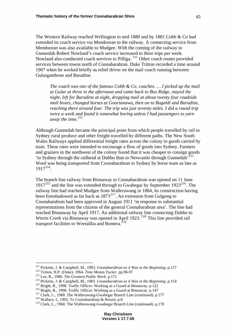
Thematic history of the former Coonabarabran Shire 45
The Western Railway reached Wellington in mid 1880 and by 1881 Cobb & Co had extended its coach service via Mendooran to the railway. A connecting service from Mendooran was also available to Mudgee. With the coming of the railway to Gunnedah Robert Nowland’s coach service increased to three trips per week. Nowland also conducted coach services to Pilliga. 211 Other coach routes provided services between towns north of Coonabarabran. Duke Tritton recorded a time around 1907 when he worked briefly as relief driver on the mail coach running between Gulargambone and Baradine.
The coach was one of the famous Cobb & Co. coaches. … I picked up the mail at Gular at three in the afternoon and came back to Box Ridge, stayed the night, left for Baradine at eight, dropping mail at about twenty four roadside mail boxes, changed horses at Goorianawa, then on to Bugaldi and Baradine, reaching there around four. The trip was just seventy miles. I did a round trip twice a week and found it somewhat boring unless I had passengers to yarn away the time.212
Although Gunnedah became the principal point from which people travelled by rail to Sydney rural produce and other freight travelled by different paths. The New South Wales Railways applied differential freight rates across the colony to goods carried by train. These rates were intended to encourage a flow of goods into Sydney. Farmers and graziers in the northwest of the colony found that it was cheaper to consign goods ‘to Sydney through the railhead at Dubbo than to Newcastle through Gunnedah’213. Wool was being transported from Coonabarabran to Sydney by horse team as late as 1917214. The branch line railway from Binnaway to Coonabarabran was opened on 11 June 1917215 and the line was extended through to Gwabegar by September 1923216. The railway line had reached Mudgee from Wallerawang in 1884, its construction having been foreshadowed as far back as 1873217. An extension from Gulgong to Coonabarabran had been approved in August 1911 ‘in response to substantial representations from the citizens of the general Coonabarabran area’. The line had reached Binnaway by April 1917. An additional railway line connecting Dubbo to Werris Creek via Binnaway was opened in April 1923. 218 This line provided rail transport facilities to Weetaliba and Bomera.219
211 Pickette, J. & Campbell, M., 1983. Coonabarabran as it Was in the Beginning. p.117 212 Tritton, H.P. (Duke). 1964. Time Means Tucker. pp.96-97 213 Lee, R., 1988. The Greatest Public Work. p.171 214 Pickette, J. & Campbell, M., 1983. Coonabarabran as it Was in the Beginning. p.154 215 Bright, R., 1998. Traffic Officer: Working as a Guard at Binnaway. p.122 216 Bright, R., 1998. Traffic Officer: Working as a Guard at Binnaway. p.147 217 Clark, L., 1968. The Wallerawang-Gwabegar Branch Line (continued). p.177 218 Wallace, I., 1992. To Coonabarabran & Return. p.8 219 Clark, L., 1968. The Wallerawang-Gwabegar Branch Line (continued). p.178
Ray Christison Version 1 17.7.06
Thematic history of the former Coonabarabran Shire 46
Plate 3.5: Binnaway Locomotive Drivers’ Rest House with a wheat wagon in the foreground.
The coming of the railway had a significant impact on the economy of the Upper Castlereagh and Pilliga regions and on the lives of the people who lived in those areas. The bulk transportation capability of the railway supported the growth of the wheat industry and also facilitated massive growth in the timber industry. When the timber industry was in its heyday in the 1920s and 1930s hundreds of sleeper cutters worked in the forests and in the 1950s thousands of sleepers were railed out of Gwabegar, Kenebri and Baradine each month. Max Clare, formerly of Gwabegar recalled the railway bringing the circus to towns along the line and the railmotor which, during the years of World War II, ran a special service to carry people from as far away as Gwabegar into Coonabarabran to attend the annual Masonic Ball. ‘The Clares remember the rail motor, driven by well-known Binnaway driver Ben Wakeling, stopping along the line to pick up people and pick flowers alongside the line.’220 The darker side of rail and transport is exemplified in the level crossing smash that occurred at Bugaldie on 9 November 1935. A lorry loaded with sleeper cutters who had spent the week working at Kenebri, and Mrs Ellen Presnell of Bugaldie and her three grandchildren, was travelling to Coonabarabran. Seven of the thirteen people riding on the truck were killed when it was struck by the locomotive of a passenger train travelling to Baradine.221 In the mid 1950s rail traffic along the Binnaway to Gwabegar line typically consisted of the following:
• Coal for Binnaway, • Drummed fuel for Murrawal and Coonabarabran,
220 Bright, R., 1998. Traffic Officer: Working as a Guard at Binnaway. p.147 221 McDonald, J., 2004. Level Crossing Smash Bugaldie 9th November 1935. pp.2-9
Ray Christison Version 1 17.7.06
Thematic history of the former Coonabarabran Shire 47
• Bulk fuel for Coonabarabran, • Bulk superphosphate for Deringulla, • Wheat shipped from Binnaway, Ulamambri, Bugaldie and Baradine, • Wool shipped from Binnaway, Ulamambri, Coonabarabran, Baradine and
Kenebri, • Stock shipped from Binnaway, Deringulla, Ulamambri, Coonabarabran,
Bugaldie and Baradine, • Live turkeys and geese shipped out of Murrawal • Milled cypress shipped from Ulamambri, Baradine and Kenebri, • Sleepers shipped from Baradine and Kenebri, • Diatomaceous earth shipped from Bugaldie.222
Service on the railway line gradually declined from the 1960s. Rail passenger services to Coonabarabran were replaced by a road coach in 1980 and Coonabarabran and Binnaway railway stations were closed in 1990223. By 1997 very little railway station infrastructure remained on the Gwabegar line beyond Binnaway. Places such as Murrawal, Deringulla, Ulamambri Yearinan, Bugaldie, Wittenbra, Baradine and Kenebri contained only remnants of their former railway installations224. In 2005 the line was closed beyond Coonabarabran, the last wheat train working from Baradine being on 23 August 2005. Roads were continually improved during the 20th century with ongoing advances in road construction techniques and funding for road improvements. The 1885 bridge over the Castlereagh River at Coonabarabran was replaced by the current bridge in 1926225. The existing timber bridge over the Baradine Creek at Baradine was constructed some time around 1923. A developmental road between Coonabarabran and Narrabri was proposed in 1929226 and funding provided in the late 1930s. The Oxley Highway was upgraded to carry motor vehicle traffic between 1928 and 1937. The 1937 Yaminbah Creek Bridge on this road was one of more than 1,000 bridges built in New South Wales by the Department of Main Roads between 1925 and 1940. It provides evidence of the adaptation of concrete technology to improve the suitability of main roads for motor vehicles.227 In 1929 the Department of Defence advised that it would provide assistance in identifying the site of an aerodrome. At this time Council moved to reserve a block of land on the western side of the racecourse for this purpose.228 In 1932 Coonabarabran Shire Council commenced development of an aerodrome on the outskirts of the town of Coonabarabran. Development of this project was progressed as an unemployment relief scheme in the Great Depression and subsequent Commonwealth funding allowed for its upgrade229.
222 Bright, R., 1998. Traffic Officer: Shunting at Dubbo and Binnaway. p.90 223 Bright, R., 2004. Traffic Officer: Station Master at Coonabarabran. pp.96 & 98 224 Wallace, I., The Line to Gwabegar. pp.108-109 225 Pickette, J. & Campbell, M. 1983. Coonabarabran as it Was in the Beginning. p.116 226 Minutes of Ordinary Meeting Coonabarabran Shire Council. 8 February 1929 227 Burns and Roe Worley and Heritage Assessment And History (HAAH), 2004. Yaminba Creek Bridge. 228 Minutes of Ordinary Meeting Coonabarabran Shire Council. 8 February 1929 229 Minutes of Ordinary Meeting Coonabarabran Shire Council. 9 November 1937
Ray Christison Version 1 17.7.06
Thematic history of the former Coonabarabran Shire 48
In the late 1950s Council considered expanding its aerodrome to accommodate commercial airlines. The development of a new airport on the Nandi Plateau was considered and approaches made to Ansett Airlines and Airlines of New South Wales regarding the possibility of establishing a regular airline service. In February 1960 Airlines of New South Wales advised that they would be interested in commencing a five-day per week service if a suitable airport was developed.230 Parallel representations were made to the Department of Civil Aviation regarding the selection of a suitable site and the Shire Engineer also prepared estimates for the construction of an airstrip capable of carrying commercial aircraft.231 It is now one of the most significant pieces of transport infrastructure in the area. An unusual use of the district’s roads occurred in September 1957. After searching throughout Australia C.O.R. (Commonwealth Oil Refineries) and BP chose a stretch of road between Wittenbra and Baradine to hold speed trials. The road was closed for two days with Ted Gray winning competition in a Lou Abrahams Tornado. First prize was £275. This event raised funds towards the construction of homes for seniors in Coonabarabran (refer Section 7.4 Welfare)232
230 Minutes of Ordinary Meeting Coonabarabran Shire Council. 16 February 1960 231 Minutes of Ordinary Meeting Coonabarabran Shire Council. 21 July 1959 & 21 June 1960 232 Grey, J. 1988. Speed Trials and the Smith Family Homes, p.19
Ray Christison Version 1 17.7.06
Thematic history of the former Coonabarabran Shire 49
4. Australian Historical Theme: Building settlements, towns and cities Although many people came to Australia in search of personal gain, the realised the need to co-operate in the building of safe, pleasant urban environments. Australian urbanisation and suburbanisation have special characteristics which set them apart from similar phenomena elsewhere in the world.233 4.1 NSW Historical Theme: Accommodation The district has numerous examples of the dwelling places of the Aboriginal people. Caves and rock shelters have been recorded in a number of places (refer to Section 2.1 Aboriginal cultures and interactions with other cultures). Some of the early European settlers also utilised caves as living or storage spaces. The most celebrated of these is Ebenezer Orr of Yaminbah who lived in a cave with his Aboriginal “shepherdesses”. Many of the early settlers built huts of bark and shingle, split slabs or wattle and daub. Rolls described the process of curing bark and setting it as roofing material:
When the sheet of bark was lifted off (the tree) it immediately rolled up. Two men straightened it and held it to soften over a low fire. Then they spread it flat and weighted it to dry. The overlapped sheets were held on the roof by crossed saplings known as ‘outriggers’ or ‘over purlins’ lashed to the purlins… On earlier roofs they were lashed with greenhide. Sometimes they were pegged down with wooden pegs. Ironbark pegs, round or square, dried slowly over a fire were almost as long lasting as nails.234
Many early houses were roofed or clad in shingles. The development of corrugated galvanised iron in 1847 revolutionised building design and construction in Australia. Cash constrained selectors, however continued to build houses of traditional materials well into the 20th century. In some communities materials for houses were scrounged from the refuse of the developing industrial economies of Britain and Australia. Packaging materials such as wooden crates and kerosene tins were used to build the houses of the poorest well into the 20th century. Marie Dundas described the house her family built behind the showground after they left Burrabeedee and moved to Coonabarabran:
We built the house of whatever we could find … If we had a piece of good tin, we’d think we was the best kids in the scrub. Cardboard – we built it out of tin first – then they’d go chop the poles… then the tin on the roof, then we’d go down to Billy Neilson’s at the goods shed and get every cardboard box ‘e ‘ad, then buy a packet of tacks, that’s our walls, cardboard walls … if it rained too much we had to throw the walls away and go down the goods shed and get more walls.235
233 Australian Historic Themes Framework, 2001. 234 Rolls, E., 1982. A Million Wild Acres. p.292 235 Somerville, M. et al, 1994. The Sun Dancin’, People and Place in Coonabarabran. pp.151-152
Ray Christison Version 1 17.7.06
Thematic history of the former Coonabarabran Shire 50
As the post industrial revolution world impacted more and more on the Coonabarabran district housing styles grew to reflect national and international trends. The towns of the area tend to reflect the patterns of house construction that have prevailed across Australia at various times, although regional variations are quite strong. Baradine contains many houses built and lined with the fine timber products of the Pilliga. Coonabarabran and Binnaway contain many examples of a distinctly regional style of timber house. These houses of Edwardian style are characterised by walls clad in rusticated weatherboards that are set as drop panels. Many have narrow bay windows surmounted by a flying gable. Commercial and civic examples of this style of construction include the West End Bakery in Dalgarno Street, the former Bugaldie Catholic Church and the Warkton School of Arts. Much housing in Binnaway reflects the impact of the development of the railway and locomotive depot. Streets of similar, railway pattern cottages characterise many parts of that town. Published histories contain many accounts of the types and standard of accommodation in the district. Elva Shumack’s history of soldier settlement at Goolhi describes the settlers originally making-do in the group accommodation afforded by the old Goolhi homestead, later moving into sheds, caravans, tents or rough shelters and eventually building houses on their selected blocks. Many of the settlers purchased pre-cut homes.236 Some vignettes of domestic life are covered in Section 8.2 Domestic life. 4.2 NSW Historical Theme: Land Tenure Prior to European settlement land tenure across Australia ‘was based upon birth and kinship rights subtly melded into a complete cosmology of life, birth, death and existence, which did not depend on separating land from person’.237 European settlers envisaged a totally different relationship to the land. They came with doctrines that saw land as a resource to be used for profit. The first pastoralists moved sheep and cattle into the area, beyond the boundaries of the colony to supplement the pastures of their landholdings in other areas. Some of these people never saw the land on which their stock were pastured. In 1836 Governor Brisbane legalised squatting beyond the limits of the 19 Counties238. The following decades saw a transition in the economy and governance of New South Wales. The first steps to responsible government were taken under the Constitution Act of 1842, transportation of convicts ceased and land ownership laws were amended to allow for the purchase of improved crown lands. These and subsequent changes saw an increase in the occupation of smaller landholdings and, in areas such as the upper Castlereagh, a gradual increase in the number of pastoral properties owned and occupied by families.
236 Shumack, E., 1999. Going Bush to Goolhi. pp.46-63 237 Kass, T., 2003 A Thematic History of the Central West. p.52 238 Morrisey, S. 1978, ‘The Pastoral Economy 1821-1850’. p.59
Ray Christison Version 1 17.7.06
Thematic history of the former Coonabarabran Shire 51
Various legislative actions by the New South Wales Parliament during the late 19th century attempted to break the hegemony of the squatters over pastoral land and break the large landholdings of this group. The Robertson Land Acts of 1861 allowed for the selection of blocks of land from 40 to 320 acres239. This legislation was intended to encourage immigration and create a class of landed yeomanry similar to that which existed in England. Many squatters used dummy purchasers to secure parts of properties over which they already held leases. The Crown Lands Resumption Act of 1884 was another government sponsored attempt to break up large landholdings. It required the halving of large properties leased from the Crown. Many large runs were broken up and portions subdivided for sale.240 Selection of land continued into the 20th century. This was supplemented after World War I and World War II by the soldier settlement schemes that continued the process of closer settlement. Soldier settlement schemes in the district included the post World War I schemes at Ulamambri, Purlewaugh and Rocky Glen and the post World War II scheme at Goolhi. The difficulties experienced by many of the post World War I soldier settlers is revealed in the ongoing saga of rates arrears brought before the Coonabarabran Shire Council. A report of February 1929 noted arrears owed on 53 soldier settler properties across the shire. These arrears totalled £2,100.241 The situation was worsened by the Great Depression with ongoing representations being made by returned solders’ organisations on behalf of these persons during the 1930s. 4.3 NSW Historical Theme: Towns, suburbs and villages 4.3.1 Coonabarabran Coonabarabran developed around a crossing of the Castlereagh River as a trading and administrative centre. Initial development included stores and inns which serviced the pastoralists of the district. Rolls notes that the first building in Coonabarabran was a “roughly built hotel” erected by James Weston in the 1850s242. A police station was established here by 1857. About the same time James Weston sold his pastoral and run hotel to Alfred Croxon. Croxon rebuilt the hotel as the Travellers’ Inn243. The Village of Coonabarabran was gazetted on 2 May 1860244. In that year ‘the first town land was sold, and a courthouse built’245. In her reminiscences published in the Journal of the Royal Australian Historical Society in 1923 Mary Jane Cain, formerly of Toorawandi, recalled that James Weston had also built a “water mill on the river, in which he ground his own wheat”. After the sale of town lots Robert Nelson (or Neilson), from Mordavale, established a large store in Coonabarabran. He later built a second hotel. According to Cain “Robert Neilson and Mr. Caddell” purchased and extended the Travellers’ Inn and also built a
239 Pickette, J. & Campbell, M. 1983. Coonabarabran as it Was in the Beginning. p.74 240 Pickette, J. & Campbell, M. 1983. Coonabarabran as it Was in the Beginning. p.119 241 Minutes of Finance Committee Coonabarabran Shire Council. 8 February 1929 242 Rolls, E., 1982. A Million Wild Acres. p.160 243 Rolls, E., 1982. A Million Wild Acres. p.173 244 Pickette, J. & Campbell, M., 1983. Coonabarabran as it Was in the Beginning. p.62 245 Heritage Office, 1996. Regional Histories. p.82
Ray Christison Version 1 17.7.06
Thematic history of the former Coonabarabran Shire 52
“large flour mill” near the police station. 246 Given the period of the mill’s construction and its location it may have been a steam driven mill.
Mary Cain also made the following observations about the development of the town in the 1860s:
There was not a lock up in the place then, but drunks were fastened with bullock-chains to a large gum-tree. Police court cases were tried in Croxon’s hotel parlour, and delinquents under short sentences were sent to Nandi, about one and a half miles away, where William Field had a store, hotel, and stable, and the last was used as a lock-up. After two prisoners escaping from such a weak stronghold a log building was erected as a gaol by Wm. Grose and Mr Smith on the spot where the present post-office stands. After this the town grew rapidly.247
The built environment of Coonabarabran reflects the steady but unspectacular development of the town since the 1890s. The central business district around John Street between Cassilis Street and the Castlereagh River provides evidence of the impact of a series of economic booms through the 20th century. Buildings such as the Hotel Royal and McDonagh’s Store testify to the confidence of the post Federation era and the strong economic conditions of the 1920s are represented by buildings such as Neilson’s in Dalgarno Street, Crane’s Building on the corner of John and Cassilis Streets, the Boronia Café and the former Union Bank (now The Jolly Cauli café). The former Bank of New South Wales (now the Coonabarabran Community Centre) and Savoy Theatre (now Hi Fi Fashions), and the reconstructed Imperial Hotel provide a record of the improving business confidence of the late 1930s. The commercial activity of the late 1930s also has expression in the imposing banking chambers set on opposite corners of John and Dalgarno Streets. The post-war building boom is evident in the reconstructed Coonabarabran Hotel and various smaller retail buildings. The domestic architecture of the town tells much the same story. Housing styles represent a substantial amount of building in the Federation era and ongoing development through the 20th century. A wide varieties of 20th century housing styles is evident in the town. These range from a regional Federation style of domestic construction, to Californian Bungalows and Post-war Austerity style houses. The influence of modernism is also strong in some properties spread throughout the town. 4.3.2 Baradine European occupation of the area around Baradine commenced in the 1830s when a run was established in the area by Andrew Brown on behalf of James Walker of Wallerawong. Brown named this run Barradean. It operated as an outstation of Goorianawa248. The Walker family held the run until 1867 when it was sold to Edward King Cox. Other early settlers in the Baradine area included Charles Fitsimmons at Bugaldie Yaminginba and James Evans at Dandry in the 1840s249.
246 Cain, M. 1923. ‘Coonabarabran in the ‘Sixties’. pp.370-371 247 Cain, M. 1923. ‘Coonabarabran in the ‘Sixties’. p.371 248 Rolls, E., 1982. A Million Wild Acres. p.117 249 Howlett, J. They Came to Baradine. 1965
Ray Christison Version 1 17.7.06
Thematic history of the former Coonabarabran Shire 53
In the early 1860s a village was surveyed at the convergence of a number of tracks which connected local pastoral stations. This point was on James Walker’s Barradean run. A 40 acre township was gazetted in 1862 and the first blocks sold in 1865. By 1866 30 people were living in the village of Baradine250. Henry Border established the first hotel in Lachlan Street in the 1860s251. The settlement must have been reasonably exposed at this time as Border’s hotel was held up at least twice by bushrangers. With a gradual growth in population came demand for services. A post office was established in 1867 and a telegraph office in 1876. A school was built from slabs in 1876. This was possibly a private venture which was supplemented or replaced by a public school in 1877. By 1885 the town boasted a population of 80 and had a court house and police station252. Land was reserved in Narren Street for a Mechanics’ Institute in 1896. This site remained vacant until 1925 when a Memorial Hall was constructed on the site253. This hall was extended in 1953 and remains as a prominent feature of the Baradine townscape. Baradine was a centre for the forestry industries which developed in the northern and western Pilliga. Timbergetters and sleeper cutters used Baradine as a base. In her account of life around the Coonabarabran district May Mead recalled how her family lived in Baradine while her father, a sleeper cutter, worked out in the forests254. As the forest industries developed after World War I Baradine grew accordingly. The inter-war period saw rapid development of the town and its institutions. All of the town’s churches and many of its existing commercial buildings were constructed during this period. 4.3.3 Binnaway A settlement developed close to crossings of the Castlereagh River during the mid to late 19th century. Larger pastoral runs, established in the Binnaway area in the 1820s and 30s began to be broken up from the 1860s after the passing of the Robertson Land Acts. Free selectors such as Charles Naseby began taking up blocks along the Castlereagh River from 1869. In 1876 Naseby lodged a subdivision plan ‘for the Private Village of Binnaway’. 255 By 1877 the population of the area was agitating for a school256, and a post office and police station had been established prior to the 1880s. A Sydney Morning Herald article described the village in February 1887:
The place is situated on the Castlereagh River, and is worthy of notice as being the centre of a most fertile country … The population of Binnaway is rather scattered, but boasts a store, post-office, accommodation house and a
250 Howlett, J. They Came to Baradine. 1965 251 Pickette, J. & Campbell, M. 1983. Coonabarabran as it Was in the Beginning. p.88 252 Howlett, J. They Came to Baradine. 1965 253 Howlett, J. They Came to Baradine, 1965 254 Sullivan, M. et al, 1994. The Sun Dancin’, People and Place in Coonabarabran. pp.131-132 255 Bull, R., 1986. Binnaway on the Castlereagh. p.5 256 Bull, R., 1986. Binnaway on the Castlereagh. p.25
Ray Christison Version 1 17.7.06
Thematic history of the former Coonabarabran Shire 54
most prolific orchard, the property of Mr McWhirter. The chief obstacle to the prosperity of the place appears to consist in the difficulty of getting there. When one arrives within three miles of the post town there are only two ways of reaching Binnaway: one is through a black sticky bog of considerable depth; the other down and up dangerous precipitous tracks … The public school has been erected in a central position, but stands isolated at a distance from the township. A few hundreds of pounds spent judiciously in improving the roads and fords would increase the prosperity of Binnaway.257
In 1904 David Innes Watt surrendered 100 acres of his property Ulindah, adjoining Naseby’s subdivision, for the establishment of a village. The village boundaries of Binnaway were proclaimed on 10 June 1909 and 42 allotments sold in November of that year.258 The construction of the railway line from Mudgee in 1917 appears to have been a major catalyst for the development of the town. Commercial establishments sprang up in the town in anticipation of the coming of the railway and the railway also encouraged the development of wheat growing in the area. With the completion of a cross-country railway line from Dubbo to Werris Creek in 1923 Binnaway was established as an important railway junction. A locomotive barracks was built in the town in 1925.259 Much of the current built heritage of the town relates to the development created by the expansion of the railway.
4.4 NSW Historical Theme: Utilities 4.4.1 Water During the early years of the settlement of the Coonabarabran water for drinking and domestic use was obtained from rivers or creeks or from barrels or tanks that collected rainwater. On properties or in settlements located away from regularly flowing watercourses wells were sunk. These were generally lined with timber to keep the water free of silt. The well in Neilson Park, Coonabarabran was originally sunk by James Weston to supply water to his house. Early government efforts to provide water included tanks and wells established on stock routes to provide water for travelling stock. Rolls described a government well on a stock route near Baradine that was fitted with a horse-drawn whim that operated two large buckets of 180 litres capacity each260. Most settlements were established on the side of watercourses from which water could be obtained. These same watercourses were dumping grounds for sewage and domestic waste. They were also watering points for increasing numbers of livestock. By the 1890s the quality of the Coonabarabran water supply had deteriorated greatly. A typhoid epidemic late in that decade created concern about water drawn from the river. In 1901 G. E. Wright sunk a well on a reserve on the northern side of the Castlereagh River. He advertised the supply of ‘pure’ water ‘in place of the germ infested water of the river’.261
257 Bull, R., 1986. Binnaway on the Castlereagh. p.6 258 Bull, R., 1986. Binnaway on the Castlereagh. p.36 259 Wallace, I., 1992. To Coonabarabran & Return. pp.8&33 260 Rolls, E., 1982. A Million Wild Acres. p.298 261 Pickette, J. & Campbell, M., 1983. Coonabarabran as it Was in the Beginning. p.139
Ray Christison Version 1 17.7.06
Thematic history of the former Coonabarabran Shire 55
Wells continued to be sunk in and around Coonabarabran during the early 20th century. By 1932, in a debate on funding a reticulated water supply, Councillor Deans reported to Council that ‘private owners have … installed £18,000 worth of bores’262. Council had also established public water supply tanks in Baradine, Binnaway and Coonabarabran. Problems with water supplies continued and much Council attention was directed towards managing public watering places and assuring clean water supply to towns and villages. During the 1920s problems were continually encountered with wandering stock fouling the Bugaldie water supply. Coonabarabran Shire Council first investigated the development of a reticulated water supply for the town of Coonabarabran in 1928. In that year it received assurances from the New South Wales Department of Works that allowance for such a scheme would be included in its 1929 budget.263 Interests in the town and within the ranks of elected Councillors, including Councillor Deans, appear to have been opposed to a reticulated water supply and lobbied unsuccessfully over an extended period for a public poll to be held on this matter. In considering options regarding the installation of a town water supply in 1932 Council sought funding of £20,000 under existing unemployment relief and infrastructure schemes. It was hoped that such a scheme would provide employment for those out of work during the worst period of the Great Depression.264 In August 1932 the Council voted 3 to 2 to accept an offer from the New South Wales Public Works Department to construct a water supply scheme for the town of Coonabarabran at an estimated cost of £21,000265. Following rejection of their proposal for a community ballot dissenting councillors lobbied the Minister for Works to stop the development pending the conduct of a poll. These actions led to some heated debate in the council chamber.266 Development of a reticulated water supply was commenced in Coonabarabran in 1932 with water being supplied from a weir constructed on the Castlereagh River near Robertson Street. Pumps installed in the Coonabarabran Power House raised water from the river to reservoirs. In the summer of 1941 Council’s Electrical Engineer estimated that 80% of the town’s water consumption was used for gardening purposes.267 In 1949 the area upstream from Council’s weir was declared as a catchment. Increases in demand led to plans being developed for a larger water storage upstream from the Robertson Street weir. The Timor Dam was constructed in 1960 upstream from Timor Rock.268 This dam continues to supply Coonabarabran. 4.4.2 Sewerage After its establishment in 1906 the Coonabarabran Shire Council began moves to improve the general health standards of the community. By May 1907 the council was
262 Minutes of Ordinary Meeting Coonabarabran Shire Council. 6 May 1932 263 Minutes of Meeting Coonabarabran Shire Council. 21 December 1928 264 Minutes of Ordinary Meeting Coonabarabran Shire Council. 6 May 1932 265 Minutes of Ordinary Meeting Coonabarabran Shire Council. 5 August 1932 266 Minutes of Ordinary Meeting Coonabarabran Shire Council. 9 September 1932 267 Minutes of Ordinary Meeting Coonabarabran Shire Council. 20 January 1941 268 Carmichael, D., 1991. Timor Valley. pp.96-99
Ray Christison Version 1 17.7.06
Thematic history of the former Coonabarabran Shire 56
debating the best ways to support improved health management and in doing so moved to declare Coonabarabran an Urban Area. The town was also declared as a Sanitary Area269. In December 1907 council sought estimates for the cost of a night soil removal service and began moves to establish a site for rubbish tips and a night soil depot270. Contracts were later arranged for night soil removal and cleaning of pans in Coonabarabran, Binnaway and Baradine. During the 1920s septic tanks were becoming common in urban areas with many commercial premises installing and gradually upgrading septic systems. Problems of overflow of septic systems seemed to occur regularly. A sewerage plant driven by windmill had been installed in Baradine by the 1930s271. 4.4.3 Electricity The 1920s saw an ongoing expansion of New South Wales’ electricity supply network. Before 1950 electricity generation and supply in the state were the responsibility of local councils. In some areas power generating plant built for large industries or mines was used to supply local towns. In Coonabarabran, with the absence of major industries, it fell to the Council to provide an electricity supply. In 1929 the Coonabarabran Shire Council voted an amount of £5,218/13/4 for the purchase of power generating plant, switchboards, transformers and electricity supply installations for the town of Coonabarabran272. Council also acquired land in Castlereagh Street to construct a power station. An electricity supply was available to parts of the town by 1930. The generators installed in the Coonabarabran Power House were driven by diesel engines. By 1937 the Coonabarabran Shire Council electricity supply had been extended to Baradine and Binnaway. Increasing demand, including the connection of the Binnaway Railway system led Council to approve the purchase of additional generating plant in June 1938.273 World War II created some interesting challenges for the Council and its Electrical Engineer. Council’s decision to purchase new generating equipment in 1938 was set against the backdrop of uncertainties of supply of equipment from Europe due to the worsening political situation in that continent. The decision to buy at this time was made with the knowledge that a delay in making the decision could seriously compromise the capacity of the local electrical supply. During the war Council resolved to release power house workers for service in the armed forces. This led to problems in staffing the plant at a time of increased demand. The power station truck and Station Engineer’s car were modified to burn gassified coal and Council voted in 1942 to give permission for the use of the truck to transport men of the 6th Volunteer Defence Corps Battalion for training purposes. Council also took steps in the same year to camouflage the power house.274
269 Minutes of Coonabarabran Shire Council. 5 July 1907 270 Minutes of Coonabarabran Shire Council. 6 December 1907 271 Minutes of Ordinary Meeting Coonabarabran Shire Council. 4 August 1932 272 Minutes of Coonabarabran Shire Council, 8 November 1929 273 Minutes of Ordinary Meeting of Coonabarabran Shire Council, 15 June 1938 274 Minutes of Ordinary Meeting of Coonabarabran Shire Council, 10 March 1942
Ray Christison Version 1 17.7.06
Thematic history of the former Coonabarabran Shire 57
From 1943 onwards Council made ongoing attempts to obtain a reliable bulk electricity supply from a major coal fired generating station. Options included Lithgow, Tamworth and Ulan power stations. Pressure on Council’s electricity supply grew during the immediate post-war years as outlying communities and newly created soldier settler areas clamoured for extension of electricity supplies. This situation was exacerbated by ongoing representations from communities such as Gwabegar and Mendooran in surrounding shires for Council to provide an electricity supply. In the face of these pressures Council resolved on 18 March 1948 to support the establishment of a proposed County Council as it was considered that this would facilitate an expansion of supply and lowering of electricity costs.275 On 17 June 1948 Council formally resolved to petition the Governor to constitute the Ulan County Council which was to include the Municipality of Mudgee, Shires of Coolah, Coonabarabran, Cudgegong and Gulgong, “A” Riding of the Shire of Cobbora and “C” Riding of the Shire of Merriwa.276 Ulan County Council was established during 1948 and formally came into existence on 1 January 1949. Coonabarabran County Council’s electricity generation and supply assets were transferred to the new County Council.277 Expansion of the electricity supply network continued with some outlying settlements not receiving an electricity supply until the 1960s.
275 Coonabarabran Shire Council Special Meeting, 18 March 1948, Shire President’s Minute. 276 Minutes of Ordinary Meeting of Coonabarabran Shire Council, 17 June 1948 277 Minutes of Ordinary Meeting of Coonabarabran Shire Council, 15 September 1948
Ray Christison Version 1 17.7.06
Thematic history of the former Coonabarabran Shire 58
5. Australian Historical Theme: Working Although a lot of what we call work is related to the economy, most of it is not undertaken for profit. A great deal of the work is done in the home is neither paid nor counted as part of the national economy. Some of the most interesting recent social history written about Australia concerns work and workplaces.278 5.1 NSW Historical Theme: Labour The diversity of work in a regional area is as diverse as the industries and communities that reside in that district. The former Coonabarabran Shire is home to a wide range of occupations linked to the land and servicing the industries that rely on the land, whether these are pastoral, agricultural, forestry, the sciences or tourism. The transport infrastructure of the region has also required labour for maintenance and operations. Road maintenance workers once were engaged to maintain particular sections of roads and railway fettlers lived along the lines they were engaged to maintain. Others experiences of the transport industry are covered in Section 3.15 Transport. A number of writers have documented historical experiences of work in the Coonabarabran district. The accounts of these writers have been drawn upon to provide a sketch of labour in the region for this thematic history. Life and work in the pastoral regions of Australia are governed by the rhythms of the seasons and the cycles of rain and drought that affect the southern continent. The demands of work vary with the growth of pasture and growth of wool. Patterns of obtaining labour for rural work varied throughout the 19th and 20th centuries. Many of the early squatters were able to access the relatively cheap labour available through the system of assigning convicts to settlers. From the 1840s free labour replaced the virtual slavery of the convict system and squatters started to seek other workforces. In various parts of New South Wales in the 1840s squatters experimented with workers from India, China and the South Pacific with varying degrees of success279. In many areas Aboriginal people proved to be the most reliable workers280. Each pastoral station maintained its core staff members who undertook or oversaw maintenance or domestic work on the property. The ongoing employment of these people, overseers, shepherds, cooks, gardeners, domestic staff, stable hands etc depended on the prosperity of the station. One local example is Uliman Station which, for much of its existence up to the 1970s, maintained a broad range of staff who lived on the property. Uliman’s infrastructure included provision for accommodation of these people and for the itinerant workers who undertook shearing, mustering and other duties. During the 20th century, and possibly in the 19th, the homestead area included stables, breaking yards, workshops including a blacksmith’s shop, a huge vegetable garden, orchards, cultivation paddocks, chook houses, butchery, laundry and a merchandise store at which locals could buy provisions. All of these required staff to operate them. 278 Australian Historic Themes Framework, 2001. 279 Buxton, G., 1967. The Riverina 1861-1891 An Australian Regional Study, p.19 280 Cain, M. 1923. ‘Coonabarabran in the ‘Sixties’. pp.370-371
Ray Christison Version 1 17.7.06
Thematic history of the former Coonabarabran Shire 59
The rural labour force was supplemented at various times of the year by itinerant workers who tramped between stations following the flow of work. Duke Tritton, who spent years on the roads of the New South Wales northwest in the early 20th century as an itinerant worker, left detailed accounts of the life of the travelling bush worker. He recalled that stations issued travellers’ rations to these itinerants ‘as a means to ensure a plentiful supply of casual labour’. The travellers’ rations prescribed by the Pastoralists’ Union consisted of ‘ten pounds of flour, ten of meat, two of sugar and a quarter of a pound of tea’. Most squatters added extras such as ‘a tin of jam or baking powder, sometimes a plug of tobacco or, in the case of a sick man, some of the rough medicines of the period’. Pastoralists noted as providers of generous handouts were popular and, according to Tritton, always had a plentiful supply ‘of men to choose from, but the tight ones were always avoided by any self-respecting swagman.281 The various tasks required to undertake a successful shearing were allocated before a shed started. The workers would elect an A.W.U. representative and then ‘put in’ a cook who then nominated his assistants. Other tasks around the shed, as described by Tritton, included:
• The “penner-up” was an important man in a shed. When the musterers brought the sheep from the paddocks to the shed, the penner-up took charge of them and was responsible for keeping the catching pens full.
• Pickers-up took the fleece as it fell on the board and spread it skin-side down on the wool table.
• Wool-rollers, two at each table, would strip three inches of skirting around it, roll the fleece, throw it in a bin where the classer would examine it and place it in a bin according to its class. The skirting went to another table where the piece-pickers would sort it into grades, clean, stained and burry.
• The pressers were kept busy. They worked on a contract system at so much per bale, and the rules of the shed did not apply to them in regard to working hours. It was not unusual to see them working long after the shearers had finished for the day.
• “The expert” is another important man in the shed. He is responsible for the smooth running of the machinery and has to have a thorough knowledge of everything mechanical in the shed.282
The late 19th and early 20th centuries saw many changes in the working lives of shearers. The change from hand to machine shearing changed the atmosphere of the sheds. Tritton described the last season of blade shearing at Conimbla station on the Castlereagh in 1905:
After the noise of the machines it was very quiet. Contrary to general opinion and well known song, shears do not click. The gullets of the hand-grips are filled with soft wood or sometimes cork. This stops the heels of the blades from meeting, so the sound is a soft “chop, chop” … The machines of the time were no faster than the blades but they cut closer and a fleece would weigh up to two pounds heavier…. There seemed to be more rhythm in a “blade-shed”,
281 Tritton, H.P. (Duke). 1964. Time Means Tucker. pp.19-20 282 Tritton, H.P. (Duke). 1964. Time Means Tucker. p.40
Ray Christison Version 1 17.7.06

Thematic history of the former Coonabarabran Shire 60
possibly because of the lack of noise. A big “machine-shed” sounds like ten thousand locusts on a hot day, with the whirring of the machines and the hum of the overhead gear and friction wheels. 283
Shearers worked bent over with heavy strain placed on their backs. ‘It was not unusual to see a man making his way on his hands and knees to his bunk. No one offered assistance as it was a point of honour to be able to reach one’s bunk under one’s own steam.’284 Prior to the beginning of the 20th century shearers worked on terms dictated by the squatter. Terms were harsh and the squatter had complete control over judging the quality of shearing and consequently the level of pay received by the shearers. A shearer not completing his contract was ‘liable to a fine or even imprisonment’285. Shearers began organising by the 1880s to achieve improved conditions. The Australian Shearers’ Union began staging strikes from 1888 and by 1891 were in full-scale conflict with the pastoralists and colonial governments286. The drought and economic downturn of the 1890s, Federation in 1901 and a large-scale shearers’ strike in 1902 created circumstances leading to improvements in working conditions. By the early 20th century pastoralists were required to provide improved accommodation for their shearers. In the 19th century ‘accommodation was rotten .. huts built of bark or slabs, with leaking roofs, no windows, earth floors, bunks in three tiers and bare boards to sleep on’287. Following the Shearers’ Agreement stations set about building better quarters. Small landholders, taking up the increasing number of blocks opened up for closer settlement during the late 19th and early 20th centuries, provided a more stable labour source for many large properties. Many free selectors found their small properties alone could not provide a sustainable living for a family and were forced to seek outside employment. Selectors along Rocky Creek and in other places provided a ready source of labour for adjoining properties. Roger Bourke, father of farmer and musician Frank Bourke, started his working life as an itinerant shearer. After starting a family with his wife Henrietta Bourke responded to the need for a family home when his wife exclaimed, ‘I’m sick and tired of moving about, Roger. I don’t care where it is, or what it is like, so long as we can stay in one place.’288 They selected land near Binnaway and later moved to a better block on Greenbah Creek. The whole family worked to clear land, plant crops of potatoes and corn and grow vegetables. Like other selectors they faced a ‘never-ending task of clearing: ringbarking, sucker bashing and stump grubbing. And there was fencing to be erected, cows to milk and rabbits to be trapped’.289 On top of these tasks the women worked hard to keep the household functioning:
283 Tritton, H.P. (Duke). 1964. Time Means Tucker. p.47 284 Tritton, H.P. (Duke). 1964. Time Means Tucker. p.41 285 Freeman, P., 1980. The Woolshed: A Riverina Anthology. p.60 286 Freeman, P., 1980. The Woolshed: A Riverina Anthology. p.60 287 Tritton, H.P. (Duke). 1964. Time Means Tucker. p.39 288 Meredith, J., 1986. King of the Dance Hall. p.11 289 Meredith, J., 1986. King of the Dance Hall. p.13
Ray Christison Version 1 17.7.06
Thematic history of the former Coonabarabran Shire 61
There was the weekly wash – water to be fetched from the well, a fire lit under the copper clothes boiler and a small mountain of soiled clothes to be rubbed and scrubbed by hand in the big zinc washing tubs, the hanging out and taking in, the problem of getting clothes dry enough to wear in rainy weather, and the nightly toil of pressing them with flat-irons in front of the fire.290
Itinerant workers and selectors sought other work when the sheds weren’t shearing. Duke Tritton recounted bouts of rabbiting, dingo hunting, tent boxing, gold prospecting and fencing the boundary between Gumin and Goorianawa:
At Box Ridge we met two brothers, Alf and Bill Freeman, who wanted a couple of mates on a fencing contract. The fence was part of the boundary between Gumin and Goorianawa. … Starting on the flat country at Goorianawa we climbed a watershed and followed it to the top of Mount Bulaway (sic.), the second highest peak in the Warrumbungles. There was no surveyed line … we had to pick our own line going from one peak to the next highest, gaining height all the way til we reached the top. When the completed job was measured we were paid for fifteen and a quarter miles; as the crow flies it would be about five. Four feet high, three foot netting, three plain and three barbed wires, it was supposed to be dingo and rabbit-proof. We had to clear the line and cut the posts as we went.291
In his books Eric Rolls provides some personal insights into work in the agricultural industries during the early and mid 20th century. This includes his description of the process of sewing and tipping wheat bags in the years before bulk handling of grains:
Until the 1960s farmers still bagged wheat on their farms. Carriers loaded the bags on their trucks and took them to the silos where contract tippers emptied them down the elevator chutes. The itinerant bag sewers … skewered the top of a loosely-filled bag with a needle thirty-five centimetres long, threaded it with a length of binder twine, drew the needle back, then tied the ends of the twine across the top of the bag. They devised quick methods for cutting the twine. Most rolled it round twenty-three litre oil drums, slashed it down one side, and tied the lengths together in bundles. They came into the paddocks about daylight, the twine dangling from keepers on their hips. They left at dark. Some sewed up to 1,200 bags a day. Bag sewing and tipping employed a lot of men in country towns. Then farmers equipped their header boxes with augers, carriers fitted bins to their trucks, and the grain was carried in bulk from paddock to ship.292
During the bumper wheat harvest of 1939-40 the Binnaway wheat silo was unable to cope with the large amount of bagged wheat received from local farmers. A special bulkhead was constructed to handle the excess wheat. Wheat lumpers were required to carry bags up a plank to pour the contents into the bulkhead. ‘The plank became so slippery with wheat that the men had to go barefoot’. Charlie Oram, the Wheat Board
290 Meredith, J., 1986. King of the Dance Hall. p.13 291 Tritton, H.P. (Duke). 1964. Time Means Tucker. p.53 292 Rolls, E., 1982. A Million Wild Acres. p.220
Ray Christison Version 1 17.7.06
Thematic history of the former Coonabarabran Shire 62
agent, was required to use 21 men in one day ‘due to men getting such sore feet that they were unable to carry on’.293 Rolls also noted the post World War II push to increase the amount of land under crops:
Farmers fitted their old tractors with rubber tyres or bought new tractors already equipped with rubbers. They fitted old generators, batteries and lights and drove night and day. The cold at seven or eight kilometres an hour on an open tractor on a frosty night is unbelievable. I’ve taken off two pairs of gloves and slapped my hands together till my fingers had enough feeling to open my penknife to cut the twine on the bags of seed. My toes pained through two pairs of socks and boots thrust inside a cocoon of wheatbags seven thick. I’ve thought of knocking off but the lights of other tractors whose drivers were braving it have kept me there. Stupefied by noise and cold we sat and spiralled round our paddocks sowing wheat.294
As noted in Section 2.4 Migration the latter half of the 20th century saw major changes in the technologies applied to work, and in the nature of local industries. These changes have had profound effects on the job skills required in the region and on the total number of persons employed. Much of the earlier seasonal work has gone with stations employing fewer hands and less opportunities for contract work. Smaller communities have consequently suffered declines in population and levels of commercial activity.
293 Bull, R., 1986. Binnaway on the Castlereagh. p.91 294 Rolls, E., 1982. A Million Wild Acres. p.220
Ray Christison Version 1 17.7.06
Thematic history of the former Coonabarabran Shire 63
6. Australian Historical Theme: Educating Every society educates its young. While European education places a great emphasis on the formal schooling system, education encompasses much more.295 6.1 NSW Historical Theme: Education Literacy and education were generally valued in societies of the British Isles from which many of the early settlers of the district came. Scotland in particular maintained quite high levels of literacy in the early 19th century. In the frontier areas of New South Wales schooling of children was often carried out by members of households. Churches also played a role in educating young people. The Sunday School movement had originally commenced in the early 19th century by evangelical sects such as the Primitive Methodists to provide basic literacy and a knowledge of the Bible296. The establishment of schools in many areas was subject to sectarian divisions and sectarianism and religion have continued to play a major role in the politics of education in New South Wales. (Refer to Section 8.4 Religion) In some instances private schools were established to educate the children of remote communities. One of the first schools in Coonabarabran appears to have been a private undertaking established by Julie Cockburn, wife of David Cockburn, at her house. Some students from properties in the region boarded at the Cockburn’s.297 As the town of Coonabarabran grew pressure mounted for the establishment of a school. One of the first suggestions for a public school came from the Reverend William Wilson, ‘the Church of England Minister who visited from Cassilis’298. Wilson proposed the construction of a building which could be used as a school during the week and for his services on Sundays. The general population of the town, not all Anglicans, applied separately in 1869 for the establishment of a vested school.
This was one where the buildings were supplied by the Council of Education and which could only be used as a school. Those who wrote were Jethro White, Presbyterian storekeeper, Owen Oxley, a Wesleyan saddler and Patrick Fitzgerald, a Roman Catholic bootmaker. They agreed to raise £110 to go towards the cost of the building. They explained that there was 35 children eligible and that the nearest school was 50 miles away.299
A school, consisting of a teaching room 22’6” x 16’, and attached four room residence were constructed of timber by John Isaac Neate for a total cost of £400. The school was opened on 31 October 1870. Alfred Davison was the first teacher appointed to the school. By 1874 enrolment had increased to 50 pupils.300 Davison was replaced by Thomas Yates who was succeeded after two years by Archibald D. McKenzie. As the school grew additional facilities were required. In the late 1870s a second classroom and wet weather sheds were constructed by George Martin at a cost of £130.
295 Australian Historic Themes Framework, 2001. 296 O, Brien, G., The Primitive Methodist Church. 297 Pickette, J. & Campbell, M., 1983. Coonabarabran as it Was in the Beginning. p.67 298 Pickette, J. & Campbell, M., 1983. Coonabarabran as it Was in the Beginning. p.83 299 Pickette, J. & Campbell, M., 1983. Coonabarabran as it Was in the Beginning. p.84 300 Pickette, J. & Campbell, M., 1983. Coonabarabran as it Was in the Beginning. pp.84-85
Ray Christison Version 1 17.7.06
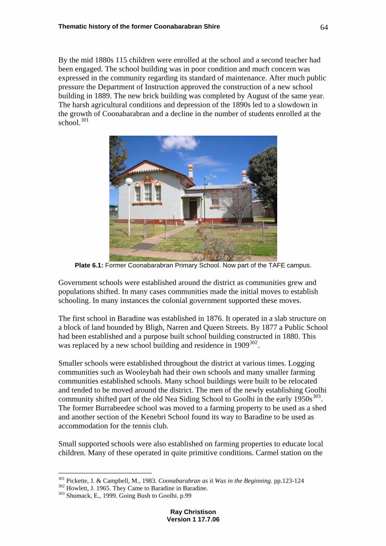
Thematic history of the former Coonabarabran Shire 64
By the mid 1880s 115 children were enrolled at the school and a second teacher had been engaged. The school building was in poor condition and much concern was expressed in the community regarding its standard of maintenance. After much public pressure the Department of Instruction approved the construction of a new school building in 1889. The new brick building was completed by August of the same year. The harsh agricultural conditions and depression of the 1890s led to a slowdown in the growth of Coonabarabran and a decline in the number of students enrolled at the school.301
Plate 6.1: Former Coonabarabran Primary School. Now part of the TAFE campus.
Government schools were established around the district as communities grew and populations shifted. In many cases communities made the initial moves to establish schooling. In many instances the colonial government supported these moves. The first school in Baradine was established in 1876. It operated in a slab structure on a block of land bounded by Bligh, Narren and Queen Streets. By 1877 a Public School had been established and a purpose built school building constructed in 1880. This was replaced by a new school building and residence in 1909302. Smaller schools were established throughout the district at various times. Logging communities such as Wooleybah had their own schools and many smaller farming communities established schools. Many school buildings were built to be relocated and tended to be moved around the district. The men of the newly establishing Goolhi community shifted part of the old Nea Siding School to Goolhi in the early 1950s303. The former Burrabeedee school was moved to a farming property to be used as a shed and another section of the Kenebri School found its way to Baradine to be used as accommodation for the tennis club. Small supported schools were also established on farming properties to educate local children. Many of these operated in quite primitive conditions. Carmel station on the
301 Pickette, J. & Campbell, M., 1983. Coonabarabran as it Was in the Beginning. pp.123-124 302 Howlett, J. 1965. They Came to Baradine in Baradine. 303 Shumack, E., 1999. Going Bush to Goolhi. p.99
Ray Christison Version 1 17.7.06
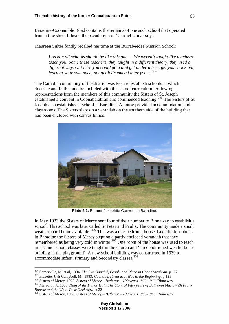
Thematic history of the former Coonabarabran Shire 65
Baradine-Coonamble Road contains the remains of one such school that operated from a tine shed. It bears the pseudonym of ‘Carmel University’. Maureen Sulter fondly recalled her time at the Burrabeedee Mission School:
I reckon all schools should be like this one … We weren’t taught like teachers teach you. Some these teachers, they taught in a different theory, they used a different way. Out here you could go a and get under a tree, get your book out, learn at your own pace, not get it drummed inter you …304
The Catholic community of the district was keen to establish schools in which doctrine and faith could be included with the school curriculum. Following representations from the members of this community the Sisters of St. Joseph established a convent in Coonabarabran and commenced teaching.305 The Sisters of St Joseph also established a school in Baradine. A house provided accommodation and classrooms. The Sisters slept on a verandah on the southern side of the building that had been enclosed with canvas blinds.
Plate 6.2: Former Josephite Convent in Baradine.
In May 1933 the Sisters of Mercy sent four of their number to Binnaway to establish a school. This school was later called St Peter and Paul’s. The community made a small weatherboard home available. 306 This was a one-bedroom house. Like the Josephites in Baradine the Sisters of Mercy slept on a partly enclosed verandah that they remembered as being very cold in winter.307 One room of the house was used to teach music and school classes were taught in the church and ‘a reconditioned weatherboard building in the playground’. A new school building was constructed in 1939 to accommodate Infant, Primary and Secondary classes.308
304 Somerville, M. et al, 1994. The Sun Dancin’, People and Place in Coonabarabran. p.172 305 Pickette, J. & Campbell, M., 1983. Coonabarabran as it Was in the Beginning. p.125 306 Sisters of Mercy, 1966. Sisters of Mercy – Bathurst – 100 years 1866-1966, Binnaway 307 Meredith, J., 1986. King of the Dance Hall: The Story of Fifty years of Ballroom Music with Frank Bourke and the White Rose Orchestra. p.22 308 Sisters of Mercy, 1966. Sisters of Mercy – Bathurst – 100 years 1866-1966, Binnaway
Ray Christison Version 1 17.7.06
Thematic history of the former Coonabarabran Shire 66
7. Australian Historical Theme: Governing This theme group is as much about self-government as it is about being governed. It includes all the business of politics, including hostility to acts of government.309 7.1 NSW Historical Theme: Defence The Coonabarabran district does not occupy a strategic geographic position in Australia and has not been a place where defence works, fortifications or defence manufacturing have played a prominent role. Memorials and honour boards throughout the district remember people from the towns, villages and properties of the area who served in Australia’s conflicts. Soldier Settlement communities throughout the district also recognise this service. The area has been involved in preparations for the defence of Australia. Local rifle clubs have long held an ancillary role in defence preparations310. In 1929 the Department of Defence offered the Coonabarabran Shire Council assistance with the identification of a site for an aerodrome and in the 1930s the same department provided funding to commence construction. During World War II Coonabarabran Shire Council applied to have a militia training camp established in the area311. Coonabarabran hosted the 6th Volunteer Defence Corps Battalion to whom Council provided the use of its power station truck. Council also camouflaged its power station against air attack312 The role of the Coonabarabran Power Station is covered further in Section 4.4.3 Electricity. In the difficult and worrying period after entry into Japan into World War II Coonabarabran Shire Council put in place plans for civil defence. In early 1942 Air Raid Wardens were appointed in the towns of Coonabarabran, Baradine and Binnaway and evacuation plans developed to cope with the eventuality of enemy attack313. Council also constructed bomb shelters in the yard of the council depot314. One of the most significant events to occur in Coonabarabran during World War II was the hosting of Italian prisoners of war on local farms (refer to Section 2.3.1 Italian Prisoners of War). Local people also remember motor vehicles fitted with gas producer units to reduce dependence on oil which was a precious strategic resource. 7.2 NSW Historical Theme: Government and administration The earliest forms of government administration in the district came through the Commissioners of Crown Lands who controlled the occupancy of rural properties and administered justice along the frontier from 1839. The Commissioner:
… was in charge of the Border Police. His duties were also to collect the fees, check on the boundaries of the runs and settle disputes. He was generally to
309 Australian Historic Themes Framework, 2001. 310 Carmichael, D., 1991. Timor Valley. p.16 311 Minutes of Ordinary Meeting of Coonabarabran Shire Council, 9 September 1941 312 Minutes of Ordinary Meeting of Coonabarabran Shire Council, 10 March 1942 313 Minutes of Ordinary Meeting of Coonabarabran Shire Council, 27 February 1942 314 Minutes of Ordinary Meeting of Coonabarabran Shire Council, 27 February 1942
Ray Christison Version 1 17.7.06
Thematic history of the former Coonabarabran Shire 67
see the smooth running of the affairs in his district. The powers given to these men were very wide. They had the right to grant licences or terminate them at any time. In their district their word was law.315
Graham ‘King’ Hunter was the first Commissioner appointed to the Land District of Bligh. In 1839 he cancelled the depasturing licence of the Cox brothers’ superintendent Roger Heenan, and cancelled the ticket of leave of one of their employees for taking an Aboriginal woman at gunpoint. He is also known to have cancelled the licence of a man named Pearce for ‘living in adultery with a white woman’ and to have given ‘the middle of one of James Walker’s lightly stocked runs to somebody else because he found no stock there’316. As the European settlements developed during the 19th century increasing numbers of government services moved into the district. These included policing and courts (Section 7.3 Law and Order), postal and telegraphic services (Section 3.3 Communication), education (Section 6.1 Education) and health (Section 3.9 Health). Other services such as Aboriginal welfare (Sections 2.1 Aboriginal cultures and interactions with other cultures and 7.4 Welfare) and forestry management (Section 3.8 Forestry) The Coonabarabran Shire Council was formed in 1906. In that year an interim council meeting in the Coonabarabran Court House made arrangements for the conduct of a council election for representatives of three ridings. The designated polling places for this election provide interesting information regarding the distribution of population within the shire at this time. Polling places were as follows:
‘A’ Riding – Erinbri, Wagga, Baradine, Bugaldi (sic), Warkton, Belar Creek, Mollyann, Coonabarabran. ‘B’ Riding – Tambar Springs, Rocky Glen, Mullaley, Purlewaugh, Coonabarabran. ‘C’ Riding – Binnaway, The Flags, Coonabarabran, Warkton, Purlewaugh, Mollyann.
From its first meeting on 7 December 1906 the council dealt with the minutiae of the regulation of animal slaughter, nuisances and road maintenance. As the Council developed it set about decades of what can best be described as nation building. During the middle years of the 20th century the Coonabarabran Shire Council developed the local road network, arranged the construction of new bridges and presided over the development of local utilities including a reticulated water supply, power generating plant and electricity supply network, sanitation systems and an airport. These schemes were envisaged in the 1920s at a time when local entrepreneur Robert Neilson was Mayor of Coonabarabran. They are further explored in sections on Transport (Section 3.15 Transport) and Utilities (Section 4.4 Utilities).
315 Pickette, J. & Campbell, M., 1983. Coonabarabran as it Was in the Beginning. pp.22-23 316 Rolls, E., 1982. A Million Wild Acres. pp.131-132 & 150
Ray Christison Version 1 17.7.06
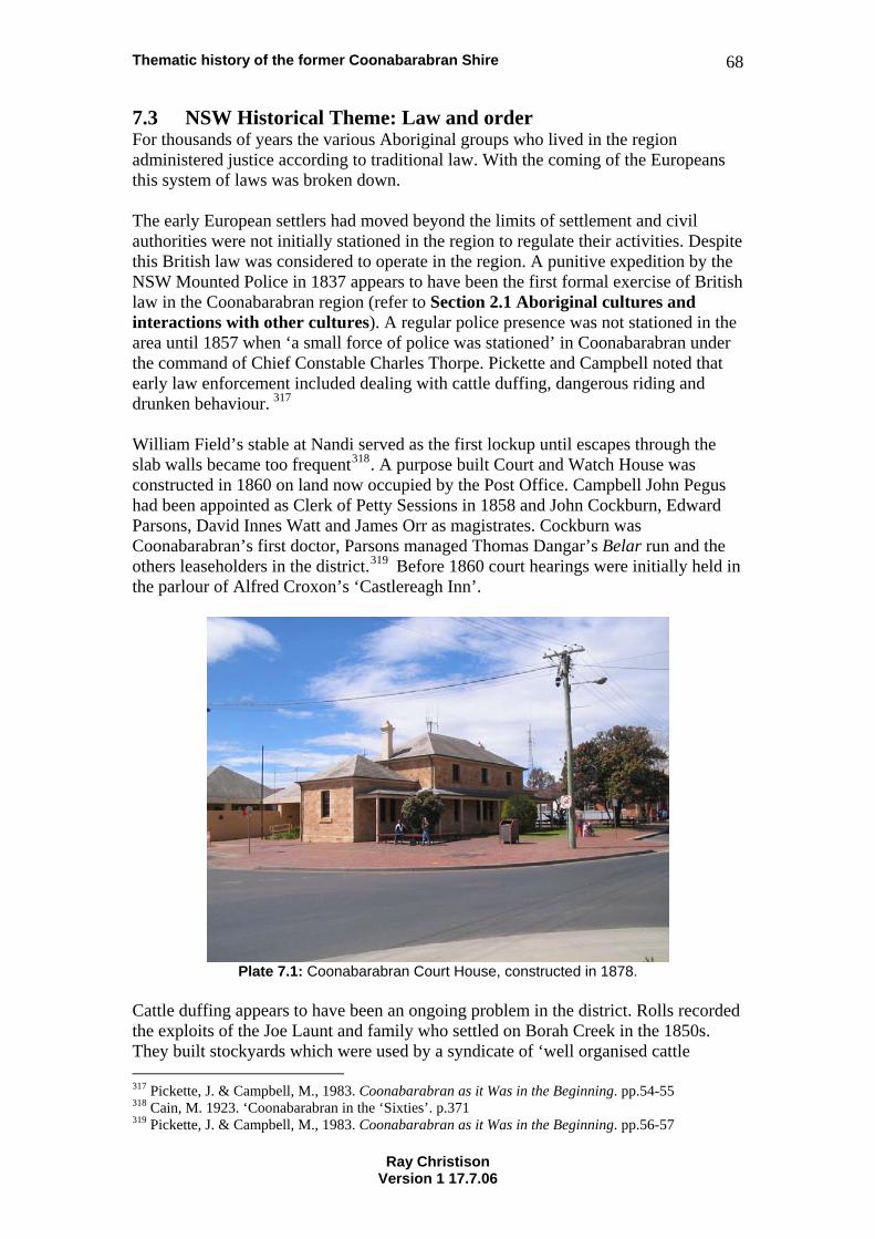
Thematic history of the former Coonabarabran Shire 68
7.3 NSW Historical Theme: Law and order For thousands of years the various Aboriginal groups who lived in the region administered justice according to traditional law. With the coming of the Europeans this system of laws was broken down. The early European settlers had moved beyond the limits of settlement and civil authorities were not initially stationed in the region to regulate their activities. Despite this British law was considered to operate in the region. A punitive expedition by the NSW Mounted Police in 1837 appears to have been the first formal exercise of British law in the Coonabarabran region (refer to Section 2.1 Aboriginal cultures and interactions with other cultures). A regular police presence was not stationed in the area until 1857 when ‘a small force of police was stationed’ in Coonabarabran under the command of Chief Constable Charles Thorpe. Pickette and Campbell noted that early law enforcement included dealing with cattle duffing, dangerous riding and drunken behaviour. 317 William Field’s stable at Nandi served as the first lockup until escapes through the slab walls became too frequent318. A purpose built Court and Watch House was constructed in 1860 on land now occupied by the Post Office. Campbell John Pegus had been appointed as Clerk of Petty Sessions in 1858 and John Cockburn, Edward Parsons, David Innes Watt and James Orr as magistrates. Cockburn was Coonabarabran’s first doctor, Parsons managed Thomas Dangar’s Belar run and the others leaseholders in the district.319 Before 1860 court hearings were initially held in the parlour of Alfred Croxon’s ‘Castlereagh Inn’.
Plate 7.1: Coonabarabran Court House, constructed in 1878.
Cattle duffing appears to have been an ongoing problem in the district. Rolls recorded the exploits of the Joe Launt and family who settled on Borah Creek in the 1850s. They built stockyards which were used by a syndicate of ‘well organised cattle 317 Pickette, J. & Campbell, M., 1983. Coonabarabran as it Was in the Beginning. pp.54-55 318 Cain, M. 1923. ‘Coonabarabran in the ‘Sixties’. p.371 319 Pickette, J. & Campbell, M., 1983. Coonabarabran as it Was in the Beginning. pp.56-57
Ray Christison Version 1 17.7.06
Thematic history of the former Coonabarabran Shire 69
rustlers operating between Victoria and … Queensland’. After suffering their depredations Ebenezer Orr led a police party, including Constables Ward and Gill, and an Aboriginal tracker named Tommy to follow the Launts. Joe Launt was captured and sentenced to two years’ hard labour in Bathurst Gaol. He vowed revenge on Orr and, after his release, was arrested on Garrawilla ‘with squares of fresh scabby sheepskin in his saddlebags… (he) was the first man tried under the … Scab Act of 1864’. 320 A number of police were killed in the district in the line of duty. Senior Constable John Ward was shot somewhere in the Mudgee District by the bushranger Sam Poo in 1865321. The Coonabarabran General Cemetery contains the grave of Mounted Constable David Peter Thompson who ‘died from injuries received on duty at Binnaway’ in June 1880. Following Ward’s death John Peter Ewing took charge of the police station at Coonabarabran. He held this role for 20 years, moving to Gunnedah in 1884.322 By the mid 1870s the original weatherboard Court House was proving to be woefully inadequate. It was replaced by the present fine sandstone building on the corner of John and Dalgarno Streets in 1878. Bushranging continued to be a problem in the region for some decades. Border’s hotel at Baradine was held up by bushrangers on at lest two occasions323. The most notorious of the bushrangers of the region were the Governor brothers who, using their exceptional bush skills, and evidently the assistance of the Aboriginal population of the region324, led police on a frantic chase back and forth across the region in 1900. 7.4 NSW Historical Theme: Welfare The concept of welfare as a function of government developed from liberal and socialist philosophies of the 19th century. The desire to create a society characterised by fairness and a just allocation of resources was one of the defining notions of the federated nation that was established on the Australian continent in 1901. This was a utopian notion that, in the eyes of many, failed to eventuate. During the 19th century and much of the early 20th century welfare was provided by benevolent institutions, the churches and friendly societies such as the Order of Oddfellows. During the 20th century government became increasingly involved in the provision of welfare services. Aboriginal Australians experienced one of the earliest exercises of a government sponsored welfare system. The NSW Aborigines Protection Board was established in 1883. This was the instrument of a philosophy that encouraged separation of Aboriginal people from mainstream society. The Board established Aboriginal reserves such as the settlement at Forky Mountain. Aboriginal people were provided with rations if they were resident in such reserves325 and were provided with separate 320 Rolls, E., 1982. A Million Wild Acres. pp.172-174 321 Pickette, J. & Campbell, M., 1983. Coonabarabran as it Was in the Beginning. p.69 322 Pickette, J. & Campbell, M., 1983. Coonabarabran as it Was in the Beginning. pp.69-70&122 323 Pickette, J. & Campbell, M., 1983. Coonabarabran as it Was in the Beginning. p.88 324 Somerville, M. et al, 1994. The Sun Dancin’, People and Place in Coonabarabran. p.116 325 Somerville, M. et al, 1994. The Sun Dancin’, People and Place in Coonabarabran. pp.135-136
Ray Christison Version 1 17.7.06
Thematic history of the former Coonabarabran Shire 70
schooling. This system has been described by Aboriginal people as a way of putting people away ‘out of sight and out of mind’326. This was a system of control. Aboriginal people were not permitted to drink in hotels and a curfew applied to their visits to towns such as Coonabarabran. Young people such as Julia Robinson were sent away to ‘dormitories’ (in her case at Brewarrina) ‘to learn how to work. We was apprenticed out to people and we had to stay four years before we came ‘ome’. After training at Brewarrina Julia worked ‘on various properties at Warkton, Narrabri and Brewarrina’.327 From the mid 20th century this system of exclusion and separation was gradually broken down as prevailing government philosophies changed. From the late 1940s the system was altered to encourage Aboriginal people to move to town. At Burrabeedee the school was closed down in 1954 and children were required to travel into Coonabarabran for their education. Leading figures in the mission community such as Queenie Robinson moved into town so they could be eligible for an aged pension because. ‘… at every turn the people were manipulated by government policy.’328 As the people moved away the Burrabeedee Mission was closed down and buildings and stock sold off by the government. The school building and houses still exist on properties around Coonabarabran. A housing estate was established on Gunnedah Hill and houses built for Aboriginal people. The church from Burrabeedee was moved to this area and converted into a pre-school. This building was eventually broken up for firewood. The Great depression, which began in 1929 and led to massive unemployment across the country, led governments to develop systems for the delivery of social welfare and to utilise unemployed people on infrastructure projects. Local councils were actively involved in the delivery of ‘emergency relief work in lieu of the dole’. Council began applying for grants to fund relief work on local roads early in 1930329. Following representations from members of the Unemployed Movement in March 1932 seeking ‘work for the unemployed to carry them over Easter’ the Coonabarabran Shire Council sought information from the Unemployed Relief Council on the number of unemployed in the district and asked for ‘£200 immediately for Easter Relief work’330. In the same year Council sought £20,000 from the Commonwealth Government for a water supply scheme ‘to absorb the unemployed about Coonabarabran. By 1933 the Coonabarabran Shire Council was arranging for work to be undertaken on a number of public facilities including Coonabarabran streets, the aerodrome, the Mechanics’ Institute, Court House, rifle range, public school and showground. Council gangers supervised work under these programs and Council received funding through the Department of Local Government. 331 Council took an active interest in relief work during the depression with the Coonabarabran town water supply being a major local initiative. Despite the fact that
326 Somerville, M. et al, 1994. The Sun Dancin’, People and Place in Coonabarabran. p.172 327 Somerville, M. et al, 1994. The Sun Dancin’, People and Place in Coonabarabran. pp.120-121 328 Somerville, M. et al, 1994. The Sun Dancin’, People and Place in Coonabarabran. p.189 329 Minutes of Ordinary Meeting Coonabarabran Shire Council. 3 January 1930 330 Minutes of Ordinary Meeting Coonabarabran Shire Council. 4 March 1932 331 Minutes of Ordinary Meeting Coonabarabran Shire Council. 1 September 1933
Ray Christison Version 1 17.7.06
Thematic history of the former Coonabarabran Shire 71
this scheme was being undertaken by the Public Works Department Councillors lobbied for better conditions for men employed on the water scheme and in late 1932 sought to have additional men employed to provide some Christmas relief. The Council also sought funding of £150 to progress the development of the Coonabarabran aerodrome and absorb ‘30 unemployed who are not accommodated on the water works’332. The regional community has continued to play an important role in the provision of welfare through a variety of community-based organisations. In 1957 representatives of the Coonabarabran Hospital Board, concerned about the need for housing for seniors, approached the organisers of the C.O.R.(Commonwealth Oil Corporation)-BP speed trials to arrange a controlled spectator area beside the Wittenbra-Baradine to raise funds for new housing333. This fundraising promotion was quite successful in rasing money for the Coonabarabran Branch of the Smith Family to purchase land in Charles Street. With matched Federal funding a group of homes for pensioners was constructed in 1960 at a cost of £5,966. A second stage was constructed in 1972 for $26,000.334
332 Minutes of Ordinary Meeting Coonabarabran Shire Council. 2 December 1932 333 Grey, J., 1988. Speed Trials and the Smith Family Homes, p.19 334 Grey, J., 1988. Speed Trials and the Smith Family Homes, p.22
Ray Christison Version 1 17.7.06
Thematic history of the former Coonabarabran Shire 72
8. Australian Historical Theme: Developing Australia’s cultural life Australians are more likely to express their sense of identity in terms of a way of life rather than allegiance to an abstract political ideal. One of the achievements of this society has been the creation of a rich existence away from the workplace. While some of the activities encompassed in this theme are pursued for profit – horse racing and cinema for instance – the reason for being is the sheer enjoyment of spectators. While many people could not pursue careers in art, literature, science, entertainment or the church without being paid, those activities do not fit easily into categories of economy or workplace.335 8.1 NSW Historical Theme: Creative endeavour Creativity has no formal boundary. Our society generally recognises a divide between the professionally creative and amateurs. In the working communities of regional areas creativity has often been expressed as an extension of daily life. Some residents of these areas have followed creative professions while many members of the community have worked beyond their normal occupations to provide pleasure and entertainment to others. Section 8.3 Leisure includes description of community activities such as dances and balls which involved creative endeavour. Binnaway’s nationally acclaimed Frank Bourke and his White Rose Orchestra are the most celebrated entertainers of the district. The Big Piano in Binnaway stands as a monument to this musical phenomenon. The district hosted many other dance bands and musical groups from the time of its first settlement by Europeans. Other local dance bands of the mid 20th century were Fred Hawkins’ Black Cat Orchestra which had it origins in Baradine and later moved to Coonabarabran, and Binnaway’s Railway Band and Stan Guy’s Rhythm Rascals336. Some members of these bands also played with the White Rose Orchestra. Frank Bourke was a great innovator who is credited with starting the concept of the circuit dance337. He also established a successful recording studio at his property Killara at Binnaway338. The Bourke brothers’ first drum kit, constructed from sections of a 44 gallon drum, the skins of kangaroos shot and cured on their family farm Killarney, hoops made from local willow branches, the converted rear vision mirror of an old truck339 represents the ultimate convergence of bush craftsmanand musiciansh
ship ip.
Binnaway was also the place in which the original 1957 movie version of D’Arcy Niland’s 1955 novel ‘The Shiralee’ was filmed. The movie, starring Peter Finch and Dana Wilson, included many scenes in and around the Royal Hotel.
335 Australian Historic Themes Framework, 2001. 336 Meredith, J., 1986. King of the Dance Hall: The Story of Fifty years of Ballroom Music with Frank Bourke and the White Rose Orchestra. pp.52&82 337 Meredith, J., 1986. King of the Dance Hall: The Story of Fifty years of Ballroom Music with Frank Bourke and the White Rose Orchestra. p.39 338 Meredith, J., 1986. King of the Dance Hall: The Story of Fifty years of Ballroom Music with Frank Bourke and the White Rose Orchestra. p.67 339 Meredith, J., 1986. King of the Dance Hall: The Story of Fifty years of Ballroom Music with Frank Bourke and the White Rose Orchestra. p.26
Ray Christison Version 1 17.7.06
Thematic history of the former Coonabarabran Shire 73
The woolsheds at Goorianawa hold a strong association with Australian folk song. The Australian folk classic ‘Click Go the Shears’ is reputed to have been written at Goorianawa and the station is itself the subject of the 19th century lyric of ‘Goorianawa’. Banjo Paterson’s 1892 ballad ‘Travelling Down the Castlereagh’ succinctly captures the massive changes that occurred in rural work patterns in the late 19th century. As in many areas the women of the district combined the need to manage meagre household budgets with high levels of creativity to fashion domestic objects. Oral histories, including Somerville’s ‘The Sun Dancin’, contain many examples of domestic creativity. Pilliga Pottery, located near the Pilliga Nature Reserve, is a modern example of creative endeavour operating in the district. 8.2 NSW Historical Theme: Domestic Life A number of histories of the region recall the rhythms of domestic life and the recurring task required to maintain a household. These rhythms swing around the relentless battles to feed families and maintain an acceptable level of cleanliness and hygiene. Scientific discoveries of the 19th century highlighted the need for domestic cleanliness to fight disease or the possibility of disease. During that century cleanliness came to be associated with moral virtue. The most despised in society were most often assessed in terms of perception of their cleanliness with ‘moral sensibility’ being presumed to be ‘governed by the same mechanisms a physiological health’. Under this paradigm ‘a poor or sick person’ was considered ‘likely to be a evil person’340. The antithesis of this was the notion that ‘cleanliness next to godliness’. Regardless of circumstances most women took great pride in the presentation of their houses. The women involved in the research of Somerville’s history of Burrabeedee had many memories of the daily routine of washing bedclothes, scrubbing floors and scrubbing tables. Children were co-opted to assist in tasks that contributed to domestic maintenance. Women in the Pilliga collected naturally occurring sodium carbonate from the soda plains to use as a cleaning agent. Rolls noted that ‘Mrs Cormie’s floors at Cumble were so white that visitors hesitated before walking on them’. He also noted that women in the Rocky Creek area collected salt from the Salt Caves to cure meat. 341 There are many accounts of cooking with camp ovens on open fires well into the 20th century. Relative prosperity translates into the sophistication of domestic working arrangements. The wealthy have always employed servants or contractors to handle difficult or unpleasant domestic tasks. Retailers have long prospered selling appliances to reduce the drudgery of domestic toil. The advent of electricity in the 1930s created markets for newer innovations and introduced much of the gadgetry of the 20th century to the area.
340 Upton, D., 1992 ‘The City as Material Culture’. p.61 341 Rolls, E., 1982. A Million Wild Acres. p.315
Ray Christison Version 1 17.7.06
Thematic history of the former Coonabarabran Shire 74
Much analysis of gendered spaces within homes has been undertaken in recent decades. Whilst informative many of these analyses seem to come from an upper class perspective that failed to recognise the role of the back door as the ‘normal’ entrance to most Australian homes or the importance of the kitchen as a gathering place. Sound archaeological analyses of the use of space within the homes of working people recognise the importance of the kitchen as a place of warmth in winter and a place of light for all kinds of close work.342 In most Australian homes the front door was a place to meet the representatives of authority, the policeman or the minister and the parlour or lounge was only used to entertain such figures, or to lay out the bodies of the newly deceased. The introduction of the radio, whether powered by mains electricity or a car battery, tended to reinforce the role of the kitchen as a gathering place. Over time the radio tended to move into the living room and television, when introduced, was often regarded as such a status symbol that it was given pride of place in the living room. House design in the 20th century tended to alter to reflect the advantages of domestic innovations. Kitchens moved into the main building and by the 1920s housing designers were promoting the ‘servantless’ house that included the modern innovations of electric or gas hot water and cooking, and electric house cleaning. The Californian Bungalow of the same era invariably included the innovation of a low-walled sleepout or sleeping porch to facilitate the Australian practice of sleeping on camp beds outside an oppressively overheated house on hot summer nights.343 8.3 NSW Historical Theme: Leisure Much of the recorded local history of the Coonabarabran district recognises the importance of leisure activities that were often communal occasions. Such activities included picnics, sporting events (refer Section 8.6 Sport), amateur theatricals and dances. In the days before mass media people tended to make their own entertainments that were often seasonal or planned around specific events such as Christmas, Queen Victoria’s Birthday (later Empire Day) or community organised carnivals. Balls and dances played an important role in bringing communities together. Pickette and Campbell note that in the 19th century dances and balls were the most popular forms of entertainment.
They were held in any hall in the district that was big enough to have room for dancing. Alex Deans and George Harper loved to play their music at these dances. They rode miles across the countryside with their instruments strapped to their horses.344
The published histories of the area all tell of dances where the participants danced all night to the sound of local musicians. Well into the 20th century groups of musicians 342 Casey, M., 2004. ‘Falling through the Cracks: Method and Practice at the CSR Site, Pyrmont’. pp.35-40 343 Butler, G., 1997. The Californian Bungalow in Australia. pp.18-19 344 Pickette, J. & Campbell, M., 1983. Coonabarabran as it Was in the Beginning. p.138
Ray Christison Version 1 17.7.06
Thematic history of the former Coonabarabran Shire 75
would gather to play for dances and other entertainments. Emily Chatfield recalled the wedding of Clive Rutley and Frieda Madden at Burrabeedee after World War II:
It was a beautiful wedding. They danced all night. We used to dance all night. One old fella had a violin accordion, old Jack Bates. He come from Coonabarabran but used t come out there and play that. Another fellow had a concertina And another fella named old Ned Fuller, he used to play the violin. They’d dance all night. And Toady, he was the best mouth organ player you ever heard.345
Dances and community events were held in all kinds of venues, including halls, shearing sheds and in houses. Queenie Robinson of Burrabeedee had a house with:
a big fireplace as wide as the kitchen. It was a dance hall, it was the kitchen, it was where every wedding was held. They used to snig a log in with a draught horse to put on the fire and she’d have the coals and a camp oven. It was lovely, lovely days they were.346
Rolls described dances in ‘a little old barn at Bugaldie’ or the sandstone floor at Rocky Glen where Wilf Watkins ‘wore out a new pair of shoes’ dancing all night.
Where there were no floors they danced on the ground in the open air. They spent weeks preparing the site. Grass was chipped and the ground was swept, watered and tamped until it was smooth and hard.347
Many of the recorded leisure activities were held to raise money for the hospital or other community ventures. At the Ulamambri Shearers’ ball, held in November 1899 an attendance of 80 men (the 30 ladies present being admitted free of charge) paying 2/6 each raised £10 for the hospital348. Former residents of Burrabeedee recall sporting events arranged by Queenie Robinson to raise money for the hospital349. The Mechanics Institute in Coonabarabran was ‘the centre for many of the entertainments to take place in the town350. Brass bands were also very popular in the 19th century with most towns boasting at least one brass or silver band. The first Coonabarabran Town Band played under the baton of Bill Sutch351. Community and memorial halls were used for a variety of social diversions and activities. The memorial hall in Binnaway became the local picture theatre, replacing a previous outdoor cinema. In the 1920s the cinema operator, Arthur Manser, would finish the evening by placing enough petrol in the cinema generator to allow ten minutes of operation. ‘He had erected light poles along Bullinda Street to give his
345 Somerville, M. et al, 1994. The Sun Dancin’, People and Place in Coonabarabran. pp.99-100 346 Somerville, M. et al, 1994. The Sun Dancin’, People and Place in Coonabarabran. p.96 347 Rolls, E., 1982. A Million Wild Acres. pp.296-297 348 Pickette, J. & Campbell, M., 1983. Coonabarabran as it Was in the Beginning. p.135 349 Somerville, M. et al, 1994. The Sun Dancin’, People and Place in Coonabarabran. p.98 350 Pickette, J. & Campbell, M., 1983. Coonabarabran as it Was in the Beginning. p.138 351 Pickette, J. & Campbell, M., 1983. Coonabarabran as it Was in the Beginning. p.139
Ray Christison Version 1 17.7.06
Thematic history of the former Coonabarabran Shire 76
patrons light on their way home, which would go out when the petrol engine ran out’.352 In Baradine the Embassy cinema, constructed in 1930, replaced the rather small memorial hall as the venue for social dances.
As the building was larger than the public hall in the town it was regularly in demand as a venue for social functions such as wedding receptions, concerts, and balls, which were very popular during those years when the theatre was available for hire. However should a ball be planned for the same night that the 'Pictures' were scheduled to take place, the 'Pictures' took priority and were shown at the usual time while the dancers would gather at the Memorial Hall, and socialise until the show was over; then the theatre seats were hurriedly pushed back against the walls and the ball goers moved down the street to the Embassy to dance the rest of the night away.353
8.4 NSW Historical Theme: Religion At the end of the 19th century religion in regional New South Wales was generally an identifier of the place from which individuals had emigrated, or in which their parents were born. ‘… Scots tended to be Presbyterians, the English Anglicans and the Welsh, Methodist while 70 per cent of the Irish were Catholics, the remainder being Anglican or Presbyterian. Some Germans were Catholics, some Lutheran.’354 Old enmities from reformation era Europe and from the English conquests of the British Isles tended to create a Protestant-Catholic divide that lasted well into the 20th century.
Various denominations worked to create their own education structures to reinforce their doctrinal position to young adherents (refer to Section 6.1 Education). Perhaps the most successful of these was the Catholic education system which relied heavily on the sacrificial service of members of the teaching orders such as the Sisters of Mercy and Sisters of St Joseph. In celebrating the centenary of the work of the Sisters of Mercy in the Catholic Diocese of Bathurst in 1966 Bishop Albert Thomas said:
The pattern has not varied much, the duties have always been the same and the performance of the duties likewise the same. Children to be taught the Love of God, adults to be brought back from the wayward path, charity expressed for the love of Christ – these were and still are the purposes why the Sisters came, why they worked …355
In the 19th century and though much of the 20th century the practice of Christianity was considered by many to be a vital aspect of citizenship. Much effort was made to bring Aboriginal people and immigrants from non-Christian countries under the influence of Christian teaching. Former residents of Burrabeedee remember the Misses Knight and Barnett who arrived in a horse and sulky in 1924 and lived in the community for 30 years. The people of Burrabeedee, including Mr Marny, built a church where Sunday School and church services were held on Sundays and sewing classes conducted on other days of the week. Misses Knight and Barnett encouraged
352 Bull, R., 1986. Binnaway on the Castlereagh. p.73 353 Hadflield, J., 2006. Notes on the history of the Embassy Theatre, Baradine. 354 Cremin, A., 2001. 1901 Australian Life at Federation: An Illustrated Chronicle, p.74 355 Sisters of Mercy, 1966. Sisters of Mercy – Bathurst 100 years – 1866-1966, Foreword
Ray Christison Version 1 17.7.06
Thematic history of the former Coonabarabran Shire 77
the children of Burrabeedee to make clothes ‘for the little kids overseas’ and donate money to be sent to ‘blind boys and girls overseas’356 Traditional aboriginal belief systems and practices demonstrated an inextricable link between land, people and belief. As mentioned in Section 2.1 Aboriginal cultures and interactions with other cultures these links were largely broken during the period of European colonisation of the area. ‘In many cases, white settlers and missionaries actively expunged Gamilaroi (Gamilaraay) cultural traditions in an attempt to ‘civilise’ and ‘assimilate’ Aboriginal people into white society.’357 Special missions were established in Western New South Wales to bring Christianity to Chinese immigrants. In the late 19th century the Methodist, Presbyterian and Anglican churches appointed Chinese-speaking ministers to carry out missionary tours throughout the colony.358 The existence of places to worship was of equal, if not greater, importance to many of the people of New South Wales. As communities were established moves were made to create spaces and buildings for the practice of religious observances. Early settlers experienced isolation from the clergy of all Christian denominations. The first clergyman to visit the Castlereagh region was the Presbyterian Rev. Colin Stewart who made regular visits from his home in the Lithgow Valley from 1839359. As Stewart was under the patronage of Andrew Brown of Cooerwull it is not surprising that he included the Brown and Walker properties of the Castlereagh on his itinerary. Roman Catholics were first visited in the 1840s by Father Dunphy from Bathurst. From 1852 Father Rigney visited from Singleton and ‘a French priest, Father Castenog, who said Mass at Field’s Hotel’. In 1861 Reverend R. Bird of the Church of England visited the district. His work was later followed up by the Reverend William Wilson who was based in Cassilis.360 The Church of England was the first to establish a full-time presence in the district and to build a church, which was completed in 1874 on a site in Robertson Street. Land for a Roman Catholic Church was dedicated in 1873 and for a Wesleyan Chapel in 1874.The Presbyterians obtained land for a church in 1875 but did not build one until 1914.361 In smaller communities the protestant denominations often joined together to build combined places of worship or ‘Union’ churches. A Union Church was constructed in Binnaway in 1926362. This church can still be seen in Bullinda Street. Coonabarabran Shire Council had given approval for the building of this church at a cost of £444 in 1926363.
356 Somerville, M. et al, 1994. The Sun Dancin’, People and Place in Coonabarabran. pp.102-105 357 Fox, P., 1996. Warrumbungle National Park. p.48 358 Wilton, J., 2004. Golden Threads: The Chinese in Regional New South Wales 1850-1950, pp.99-101 359 Pickette, J & Campbell. M., 1983. Coonabarabran as it Was in the Beginning. p.95 360 Pickette, J & Campbell. M., 1983. Coonabarabran as it Was in the Beginning. p.96 361 Pickette, J & Campbell. M., 1983. Coonabarabran as it Was in the Beginning. pp.96-97 362 Binnaway Centenary Committee, 1963. A History of Binnaway. p.50 363 Minutes of Ordinary Meeting of Coonabarabran Shire Council, 3 September 1926
Ray Christison Version 1 17.7.06
Thematic history of the former Coonabarabran Shire 78
A Union church had been built in Baradine some time around 1899. Early church services in Baradine had been held in private homes. It served for worship and also as a school for many years. The Anglican and Presbyterian churches of Baradine were built during the years between 1920 and 1940. Small churches were built in outlying communities and in some instances community halls such as that at Goolhi were used for church services. The built heritage of the former Coonabarabran Shire reflects the ascendancy of Christianity in its towns and villages. Each of the larger towns has its collection of Anglican, Catholic, Methodist and Presbyterian Churches that were built by public subscription and community effort. Small church buildings, such as St Michael’s Catholic Church at Purlewaugh and St Paul’s Anglican Church in Kenebri, dot the rural landscape. Coonabarabran also features places of worship of non-conformist Protestant denominations. The tiny Assembly of God Hall in Cowper Street is a neat example of such buildings. 8.5 NSW Historical Theme: Social Institutions Australian communities share common threads of community endeavour. Social organisation, social services and social cohesion have long been supported by societies established for the good of their members and/or the good of the community. Volunteer effort drives and sustains many of these institutions. The built environment is studded with buildings, monuments and works which stand as testament to the development and impact of these organisations. One of the most enduring of these is the Country Women’s Association which was founded in New South Wales in April 1922. Formed to foster the ‘community spirit’ and a sense of ‘self help’364, the CWA has branches in almost all communities and is active in providing a focus for the women of the country. Early campaigns of the CWA included ongoing lobbying and agitation to improve women’s health services and create maternity and mother care facilities in public health facilities365. CWA Branches continue to raise money for charities and community projects, as well as catering for social functions. The CWA established in Coonabarabran in the mid 1920s, and at Baradine366 and Binnaway367 in 1928. Freestanding CWA halls exist in the larger towns and include the 1961 Baradine CWA Rooms that were constructed as a meeting place and a women’s health centre. In smaller communities the CWA facilities are combined with the community hall. Purlewaugh’s Mechanics Institute is built next to and connected with the CWA Hall. At Goolhi the Progress Association and CWA function in one building. The CWA played a major role in fundraising for the Goolhi Hall368 and still uses the hall as its base. In other locations such as Rocky Glen and Purlewaugh the CWA share facilities with other community organisations. The Manchester Unity Order of Oddfellows (MUIOOF) operated in Coonabarabran. In the days before large-scale government funded social welfare organisation such as 364 Kingston, B. (ed.), 1977. The World Moves Slowly. p.36 365 Kingston, B. (ed.), 1977. The World Moves Slowly. p.36 366 Hadfield, J., 2006. Notes on the history of the Baradine CWA Rooms. 367 Bull, R., 1986. Binnaway on the Castlereagh. p.74 368 Shumack, E., 1999. Going Bush to Goolhi. pp.92-93
Ray Christison Version 1 17.7.06
Thematic history of the former Coonabarabran Shire 79
this provided health and sickness benefits to its members. It was also a point of social networking for people moving between communities. Lodge members often found referrals for employment or other assistance through the Oddfellows. A Lodge of the MUIOOF was formed in Coonabarabran in 1878369 and held its first ball in 1881. This continued as an annual event until World War I. The society built a hall in Cowper Str 370eet.
The Freemasons were also active in the area, establishing lodges in the larger communities. The Lodge Timor No.274 built a substantial hall in Cassilis Street in 1923 and Lodge St Andrew was constructed in Baradine in 1956. A Mechanics Institute was formed in Coonabarabran and held its first monthly entertainment in June 1876. The social activities of this organisation were popular. They acquired the block of land on John Street between Cassilis and King Streets. A hall, containing a library ‘and a large room where concerts, dances and public meetings could be held’ was built in 1877. A new brick building was erected adjacent to the original hall in the early 20th century.371 The Coonabarabran Club was established in 1951 to provide an in-town facility for people from properties who travelled to Coonabarabran to transact business372. The Club purchased a house in Cassilis Street for the use of its members and continues to provide a meeting place on these premises. 8.6 NSW Historical Theme: Sport Human beings have always engaged in competitive activities that have been designed to train members of society for work or war. Team sports have also been used to enhance social cohesion and redirect individual attention away from social or economic hardships. In regional areas sports have provided opportunities for communities to connect with neighbours and with persons in other communities. Tennis provides a powerful example of the role of sports in community development within the former Coonabarabran Shire. Tennis courts, and the remnants of tennis courts, dot the landscapes of almost all current and former communities. It is also unusual for pastoral properties to be without a tennis court. Tennis was particularly popular from the 1920s to the 1970s. The large courts complexes at Goolhi and Baradine are examples of the community effort applied to the development of communal courts. Cricket has long been popular with communal cricket grounds being developed in many places. The atmospheric cricket pitch in a bush clearing at Purlewaugh is a fine example of the facilities developed for those described by Kipling as ‘flannelled fools.’ Horse racing has long been popular with the first formally recorded event being held in 1867373. Pickette and Campbell described district race meetings in the 1890s:
369 Pickette, J & Campbell. M., 1983. Coonabarabran as it Was in the Beginning. p.112 370 Pickette, J & Campbell. M., 1983. Coonabarabran as it Was in the Beginning. p.134 371 Pickette, J & Campbell. M., 1983. Coonabarabran as it Was in the Beginning. pp.104-106 372 Coonabarabran Senior Citizens, 2003. Easy Walks in Coonabarabran. 373 Pickette, J. & Campbell, M. 1983. Coonabarabran as it Was in the Beginning. p.82
Ray Christison Version 1 17.7.06
Thematic history of the former Coonabarabran Shire 80
Race meetings were not only held in the town, but also in the smaller settlements and on the big stations of the district. Sometimes they lasted as long as four days. The publicans all made sure to be there so that the winners could celebrate and the losers drown their sorrows. Upwards of three hundred race enthusiasts usually turned up. The horses had to be brought here days before the races… The frivolities did not stop when the horses had been stabled for the night. Music and dancing and the odd “nip” or two, was available at any of the hotels on race nights. On the most favourable night, the Jockey Club held its Race Ball.374
Cycling was popular from the 1890s with a club being formed in Coonabarabran. They held meetings at the showground that were large enough to be supplied with spirits by the local hotels.375 Rifle shooting has long been popular. This activity was supported by colonial and Commonwealth governments as part of the country’s defence infrastructure. The Coonabarabran Rifle Club was founded some time around 1901 and had established a rifle range on the Timor Road by 1909. In the early 20th century ‘Interclub shoots were conducted with Binnaway, Tooraweenah and Coonamble’.376 Other sports have been more closely linked to the skills required on the land or in the forests. Horse-pulls, wood chopping, camp drafts and polocrosse have all provided opportunities to demonstrate skills and abilities linked to the occupations of the contestants. These sports have grown beyond the occupational area to become pastimes in their own right. There were also other motivations for organising sports. Rolls noted that for many years cockfighting was carried out on Sundays ‘on a vacant corner block in Baradine’377. The Centenary History of Baradine, published in 1963 listed tennis, rifle shooting, football, golf, cricket and bowls as being popular in the town378. The late 20th century saw the development of swimming facilities with war memorial swimming pools being constructed in Coonabarabran between 1953 and 1957, Baradine in 1961 and Binnaway in 1965. Prior to the construction of these pools swimming holes in local creeks and rivers were popular places to cool off. Willow Vale was a much-frequented spot in Coonabarabran. The people of Binnaway frequented the deep hole at Greenbah and the length of river around the cement bridge379. In 1940 the Coonabarabran Chamber of Commerce proposed the development of a swimming pool by construction of a weir in the bed of the Castlereagh River at the Nandi Reserve. At the request of Council the Shire Health Inspector investigated the proposal and advised Council that:
374 Pickette, J & Campbell. M., 1983. Coonabarabran as it Was in the Beginning. pp.133-134 375 Pickette, J & Campbell. M., 1983. Coonabarabran as it Was in the Beginning. p.133 376 Carmichael, D., 1991. Timor Valley. pp.16-18 377 Rolls, E., 1982. A Million Wild Acres. p.296 378 Binnaway Centenary Committee, A History of Binnaway. pp.37-49 379 Bull, R. 1986. Binnaway on the Castlereagh. p.66
Ray Christison Version 1 17.7.06
Thematic history of the former Coonabarabran Shire 81
• Access would be dangerous, • The depth of the water at the weir would be ‘insufficient … for the purposes of
diving’, • The water retained by the weir would be subject to pollution from surface
drainage, organic growths and bathers. The pool would no have no means of sterilisation.380 (Coonabarabran Shire Council, 1941)
Council did not support the Chamber of Commerce proposal but agitation for a community pool must have continued throughout the 1940s. Council considered a proposal for a children’s swimming pool in Neilson Park. This was to include showers and concrete slabs for adults and children.381 (Coonabarabran Shire Council, 1942)
380 Minutes of Ordinary Meeting of Coonabarabran Shire Council, 13 January 1941 381 Minutes of Ordinary Meeting of Coonabarabran Shire Council, 10 February 1942
Ray Christison Version 1 17.7.06
Thematic history of the former Coonabarabran Shire 82
9. Australian Historical Theme: Marking the phases of life
Although much of the experience of growing up and rowing old does no readily relate to particular heritage sites, there are places that can illustrate this important theme. Most of the phases of life set out below are universal experiences.382 9.1 NSW Historical Theme: Birth and death Birth and death mark the beginning and end of life. The rituals and beliefs surrounding both are makers of culture. During the period since the European occupation of the Coonabarabran district birthing practices have changed dramatically with a shift from home birthing guided by the wisdom of midwives to 20th century notions of assisted and medically supervised birth. The presence of some birthing hospitals in the region is covered in Section 3.9 Health. The isolation of many women in regional areas, and the distances from which help had to be called, led to the death of many women due to the complications of childbirth or post-natal crises. Local histories contain many tragic stories of early female deaths associated with childbirth. Country women, led by the Country Women’s Association, began to agitate in the 1920s for improved birthing facilities and mothercare support to ‘save the babies for Australia’. The Association asserted:
… that five hundred nursing mothers were lost in 1924 in New South Wales through the lack of proper accommodation and nursing … ‘Women are no more born mothers than they are born lamplighters,’ says a prominent worker of the Association. ‘All women need to be taught to be good mothers. The city provides ample facilities, and it is the Country Women’s Association’s aim to provide suitable enlightenment to the women of the west.’383
Specific sites in the former Coonabarabran Shire associated with birth include Nurse Taylor’s Hospital in Cassilis Street, Coonabarabran and the Baradine CWA Hall. Located within the area are a number of Aboriginal sites associated with the transition from childhood to adulthood. These include the bora ground adjacent to Nandi Hill and the bora ground at Hickeys Falls. The former Coonabarabran Shire contains many sites in which the dead have been interred or remembered. These range from Aboriginal burial sites, including the cave burial of the girl with the dillybag recorded by Somerville, to isolated European graves such as the lonely pair at The Aloes in the Pilliga, the Carlow family graves on Dandry, the unique cemetery of Burrabeedee, village cemeteries such as that at Bugaldie and the Victorian era cemeteries of larger towns such as Baradine, Binnaway and Coonabarabran. Small cemeteries and isolated graves dot the region, providing testament to the practices of burial prevalent during the 19th and early 20th centuries.
382 Australian Historic Themes Framework, 2001. 383 Kingston, B. (ed.), 1977. The World Moves Slowly. p.36
Ray Christison Version 1 17.7.06
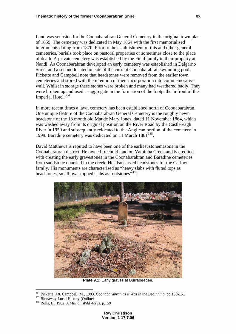
Thematic history of the former Coonabarabran Shire 83
Land was set aside for the Coonabarabran General Cemetery in the original town plan of 1859. The cemetery was dedicated in May 1864 with the first memorialised internments dating from 1870. Prior to the establishment of this and other general cemeteries, burials took place on pastoral properties or sometimes close to the place of death. A private cemetery was established by the Field family in their property at Nandi. As Coonabarabran developed an early cemetery was established in Dalgarno Street and a second located on site of the current Coonabarabran swimming pool. Pickette and Campbell note that headstones were removed from the earlier town cemeteries and stored with the intention of their incorporation into commemorative wall. Whilst in storage these stones were broken and many had weathered badly. They were broken up and used as aggregate in the formation of the footpaths in front of the Imperial Hotel.384 In more recent times a lawn cemetery has been established north of Coonabarabran. One unique feature of the Coonabarabran General Cemetery is the roughly hewn headstone of the 13 month old Maude Mary Jones, dated 11 November 1864, which was washed away from its original position on the River Road by the Castlereagh River in 1950 and subsequently relocated to the Anglican portion of the cemetery in 1999. Baradine cemetery was dedicated on 11 March 1881385. David Matthews is reputed to have been one of the earliest stonemasons in the Coonabarabran district. He owned freehold land on Yaminba Creek and is credited with creating the early gravestones in the Coonabarabran and Baradine cemeteries from sandstone quarried in the creek. He also carved headstones for the Carlow family. His monuments are characterised as “heavy slabs with fluted tops as headstones, small oval-topped slabs as footstones”386.
Plate 9.1: Early graves at Burrabeedee.
384 Pickette, J & Campbell. M., 1983. Coonabarabran as it Was in the Beginning. pp.150-151 385 Binnaway Local History (Online) 386 Rolls, E., 1982. A Million Wild Acres. p.159
Ray Christison Version 1 17.7.06
Thematic history of the former Coonabarabran Shire 84
Early in the life of the Aboriginal community at Forky Mountain (later Burrabeedee) those who had passed away were buried at the foot of Forky Mountain387. A small formal cemetery was later established near the base of the mountain. Many of the older graves in this cemetery are decorated with flowers, glass and fragments of china.388 Later Sam Smith of Burrabeedee carved many of the headstones, carrying blocks of sandstone on his back from Porcupine Cave. He fashioned these headstones ‘with a crosscut saw and a chisel and a hammer’.389 Former residents of Burrabeedee recounted their memories of the rituals that accompanied the passing on of a family member. Bodies were laid out in the front room on a table. All pictures were removed from the room and candles burned constantly. And members of the community would take turns sitting up with the deceased. The women would sew shrouds of calico. Wreaths were made by the women and children from wildflowers.390 9.2 NSW Historical Theme: Persons A number of prominent citizens of the former Coonabarabran Shire have been listed in this section in alphabetical order. Accounts of these persons are taken from previously published sources. There are may more people who have made significant contributions to the region. Some are mentioned in other sections of this history. Frank Bourke OAM, born in 1923 as the youngest son of shearer and free selector Roger Bourke from Merriwa and his wife Henrietta Brooks from Belar Creek, is perhaps the most highly acclaimed of the residents of the Coonabarabran district. He grew up with a passion for music that led him into a career as a dance band leader and songwriter. From the 1930s to the 1960s Frank Bourke and his White Rose Orchestra played at dances all over western New South Wales and up into Queensland. They became famous for their original music and highly disciplined rhythm. The precision of their playing ensured that they were called upon to play at the most prestigious balls from Lithgow to Bourke. Frank’s innovative style and business sense led to the establishment of a regular radio show that was aired throughout the west of the state. He also established the concept of the circuit dance whereby the band booked halls throughout a region, playing each night of the week. His promotional ability eventually led to the establishment of Frank Bourke Records and the construction of a recording studio on his property Killara at Binnaway. He was also an active member of the community, serving as a Councillor of Coonabarabran Shire and Ulan County Council, local government representative on the Regional Advisory Council, member of the Warrumbungle National Park Trust, President of the Binnaway Branch of the Australian Labour Party, the Binnaway Show Society and the New Mollyann Hall Committee in Binnaway.391 Mary Jane Cain, the daughter of Jinnie and Eugene Griffin, was born at Toorawindi in 1844. She grew to become a shepherd and eventually took on the role of ‘Queen of the Aborigines’. Her mother Jinnie had been a consort of King Cuttabush (refer to Section 2.1) and it has been assumed that she carried some authority from this 387 Somerville, M. et al, 1994. The Sun Dancin’, People and Place in Coonabarabran. p.86 388 Somerville, M. et al, 1994. The Sun Dancin’, People and Place in Coonabarabran. p.2 389 Somerville, M. et al, 1994. The Sun Dancin’, People and Place in Coonabarabran. p.205 390 Somerville, M. et al, 1994. The Sun Dancin’, People and Place in Coonabarabran. p.86 391 Meredith, J., 1986. King of the Dance Hall: The Story of Fifty years of Ballroom Music with Frank Bourke and the White Rose Orchestra. p.64
Ray Christison Version 1 17.7.06
Thematic history of the former Coonabarabran Shire 85
relationship. She clearly held a high level of personal authority to whom ‘even Mr Neilson and them [government authorities]’ listened to. A very capable woman Mary arranged a landholding at Forky Mountain for herself and her family. This place became a refuge and Aboriginal people came there from all over the northwest392. She died in Coonabarabran in 1929393, an article in the Coonabarabran Times describing the high regard in which she was held throughout the region:
Mrs Cain was known and loved by all from a very great distance around this district and outside it, and a word against her, had anyone been foolish enough to utter it, would have evoked the undying hostility of the oldest and most respected families of the North Western slopes and Central West. Many of today’s most powerful scions of the House of Merino were nursed or fondled by her in their young days and entertain feelings of fierce and belligerent affection it would be good not to challenge.394
Dr Eric Corry of Binnaway was awarded an MBE in 1961 ‘in recognition of his humanitarian work amongst the people of this district for almost 50 years’. He purchased the medical practice in Binnaway from Dr. Castleden on 7 April 1925. Born in Victoria and educated in England as a medical student he served in the Royal Navy in World War I before emigrating to New Zealand and then Australia. He practiced medicine from a surgery in the main street of Binnaway and then later from his home. In addition to his contribution to the life and amenity of Binnaway Dr Corry was a keen sports person. A member of the Cooma and Coolah Acclimatisation Societies he advocated the propagation of native fish species. He was also a member of the British Falconry Club who wrote articles on the subject of falconry and exported young birds collected from the cliff face of Mowrock.395 Dr Corry was recognised as being responsible for the tree plantings in the main streets of Binnaway.396 Robert Neilson came to Coonabarabran from Gulgong in 1870. In Gulgong he had worked as a bookkeeper for the Rouse family on Biranganbil station, having previously worked in the post office at Windsor. He had apparently identified an opportunity for the establishment of a retail store in Coonabarabran and commenced trading in a ‘structure of hessian and bark’. In partnership with Thomas Cadell, a relative of his mother, he purchased James Weston’s Castlereagh Inn in Dalgarno Street. The inn was demolished and a new retail establishment constructed. This traded as Robert Neilson & Co. He also constructed a steam flour mill on the corner of John and Dalgarno Streets (refer Section 3.10)397. The mill was a prominent feature of John Street for many years.
As well as the store and flour mill Neilson owned the Tradesman’s Arms Hotel which was later changed to the Club House. This establishment was located next to Neilson’s store and leased to various licencees.398
392 Somerville, M. et al, 1994. The Sun Dancin’, People and Place in Coonabarabran. p.52 393 Somerville, M. et al, 1994. The Sun Dancin’, People and Place in Coonabarabran. p.51 394 Somerville, M. et al, 1994. The Sun Dancin’, People and Place in Coonabarabran. p.66 395 Bull, R., 1986. Binnaway on the Castlereagh. pp.61&109 396 Bull, R., 1986. Binnaway on the Castlereagh. p.79 397 Pickette, J & Campbell. M., 1983. Coonabarabran as it Was in the Beginning. pp.93-94 398 Pickette, J & Campbell. M., 1983. Coonabarabran as it Was in the Beginning. pp.94,123,148
Ray Christison Version 1 17.7.06
Thematic history of the former Coonabarabran Shire 86
Neilson was an active member of the Coonabarabran community. His name appears on the list of members of the school board and the 1875 list of trustees of the Presbyterian Church399. He also made his premises available for the third concert arranged by the Mechanics Institute400. Neilson Park at the bottom of John Street was named for Robert Neilson in 1935 in honour of his role in developing Coonabarabran. Neilson’s store burnt down in 1920 and a new store was constructed. The store operated until the 1990s. The name of the Pincham family became synonymous with sawmilling in the Baradine district. The precise date at which the family became involved in the industry has been long forgotten by their descendants, but what is known that Jim Pincham and his brother Bill owned and operated a sawmill in Coonabarabran for some years prior to Jim's death with typhoid in 1896. What happened next is uncertain, but it seems that Jim's wife, Sarah, and her brother in law did not get on, and for the next several years the main source of income for Sarah and her family was what she made by dressmaking and later running a boarding house in Coonabarabran.401 However Jim and Sarah's eldest son, Alf, apparently worked in the Coonabarabran mill so that when, probably in 1909, Sarah managed to buy her brother in law's share and have the mill moved to a property near Baradine, Alf was able to help her to operate it. Her other sons, Bruce and Roy (otherwise known as Gollagher) worked with him as they were old enough.402 After setting up the mill a couple of times on private property the Pincham family moved north into the scrub, and in 1930 bought part of Kenebri from John Miller where they established themselves more permanently. Called Milliwindi, the mill remained in operation there for many years. The family firm continued to expand, first buying an existing mill about two miles north of Baradine, then setting up a more substantial sawmill on the outskirts of the town. This was the first sawmill in the district to be run by electricity. The extension of the electricity scheme to the township if Baradine, first envisaged in 1935, was finally achieved by May 1938, and Sarah Pincham and her family saw it as the practical way to go. According to Norman Pincham, Sarah's Grandson, freezing works were also established on the mill site, providing ice for both individual customers and the local stores.403 John Brophy Renshaw (Jack) Renshaw, Premier of New South Wales from April 1964 to May 1965 was a long time resident of Binnaway. He was born in Wellington in 1909 and educated Binnaway Central School, Patrician Brothers School, Orange and Holy Cross College, Ryde404. In 1933 with his brothers he opened J. R. Renshaw
399 Pickette, J & Campbell. M., 1983. Coonabarabran as it Was in the Beginning. p.97 400 Pickette, J & Campbell. M., 1983. Coonabarabran as it Was in the Beginning. p.104 401 Hadfield, J., 2006. Notes on the history of Pincham’s Sawmill in Baradine. 402 Hadfield, J., 2006. Notes on the history of Pincham’s Sawmill in Baradine. 403 Hadfield, J., 2006. Notes on the history of Pincham’s Sawmill in Baradine. 404 John Brophy Renshaw, Mr (Online)
Ray Christison Version 1 17.7.06
Thematic history of the former Coonabarabran Shire 87
and Co. This firm operated a butchery, stock and station agency and oil and fuel depot405. An active member of the Australian Labor Party from 1930 Jack Renshaw was elected as a Councillor of Coonabarabran Shire in 1937 and served as Shire President in 1939 and 1940.406 He was elected Member of the Legislative Assembly for Castlereagh in 1940 and retained the seat until 1980. He was a member of the North Executive Wheat Growers’ Union until 1940 and held a number of branch, regional and state roles in the Labor Party, including New South Wales leader from 1964 to 1968.407 Renshaw served as Premier of New South Wales from 30 April 1964 to 13 May 1965. During his time in parliament he also served in the following portfolios:
• Secretary for Lands - 1950 to 1952, • Secretary for Public Works and Assistant Minister for Local Government -
1952 to 1953, • Secretary for Public Works and Minister for Local Government – 1953-1956, • Minister for Local Government and Minister for Highways – 1956-1959, • Deputy Premier and Treasurer – 1959-1962, • Minister for Lands – 1960-1961, • Minister for Agriculture – 1961-1962, • Deputy Premier, Treasurer and Minister for Industrial Development and
Decentralisation – 1962-1964, • Treasurer and Minister for Industrial Development and Decentralisation –
1964-1965 • Treasurer – 1976-1980
Jack Renshaw died at Northbridge on 18 July 1987408. Gerald John Sullivan, Member of the NSW Legislative Assembly for Wollongong for two terms from 1991, was born in Binnaway in 1943. He attended Binnaway Central School and Coonabarabran Intermediate High School before moving to Sydney to complete a teacher’s certificate.409 David Innes Watt was born in 1855, the son of David Watt and Jane McMaster. David Watt Snr. obtained occupancy of the properties of Mowabla and Ulindah in 1863. He was a Magistrate in the Binnaway district. On the death of his father in 1879 David Innes Watt purchased Ulindah. He later purchased Gowang, Kerbin and Yarragrin. He married Emmaline Blackman in 1885 and together they raised eight children.410 In 1900 Watt gave up much of the river frontage of Ulindah for closer settlement411, and in 1904 surrendered 100 acres, which was reserved for village purposes. This, combined with land previously subdivided by Charles Naseby, became the basis of 405 Bull, R., 1986. Binnaway on the Castlereagh. p.114 406 Alexander, J. (ed), 1950. Who’s Who in Australia XIVth Edition, p.603 407 John Brophy Renshaw, Mr (Online) 408 John Brophy Renshaw, Mr (Online) 409 Death of Gerald James Sullivan, NSW Legislative Assembly Hansard, 08/08/2000 410 Bull, R., 1986. Binnaway on the Castlereagh. p.9 411 Bull, R., 1986. Binnaway on the Castlereagh. p.9
Ray Christison Version 1 17.7.06
Thematic history of the former Coonabarabran Shire 88
the town of Binnaway412. His legacy to the town is celebrated in the names of David Street, Innes Street, Watt Street and Ulinda Street. David Innes Watt was active in the community as President of the Coonabarabran Amateur Race Club for 20 years, a golf and polo champion, member of the Pastures Protection Board and Councillor of Coonabarabran Shire Council. He died in 1924.413 John Anderson , although not a Coonabarabran Shire resident, has represented the area in the Commonwealth parliament. He was born on 14 November 1956 and educated at King’s School, Parramatta. He then studied at the University of Sydney, residing at St Paul’s College. John graduated as Master of Arts. John is a well known farmer and grazier in the region. He married Julia Robertson in 1987 and together they have three daughters and two sons. A member of the Nationals and resident of Warrumbungle Shire John represented the Federal seat of Gwydir from 1989. He served in various ministerial portfolios including Transport and Regional Services and Primary Industries and Energy. From 1999 to 2005 John was leader of the Nationals and Deputy Prime Minister of Australia.414
412 Bull, R., 1986. Binnaway on the Castlereagh. p.36 413 Coonabarabran DPS Local & Family History Group, David Innes Watt - Ulinda 414 Pearce, S. & Herd, M. (eds.), 2006. Who’s Who in Australia 2006. p.139
Ray Christison Version 1 17.7.06
Thematic history of the former Coonabarabran Shire 89
10. References Alexander, J., 1950.
Who’s Who in Australia XIVth Edition. Melbourne, Colorgravure Publications Anglo Australian Observatory, 1999. Information sheet. Epping, Anglo Australian Observatory. Anglo-Australian Observatory [Online]. Available: http://www.aao.gov.au/about/abouttheaao.html (2006, February 1) Apperly, R., Irving, R. & Reynolds, P., 1995.
A Pictorial Guide to Identifying Australian Architecture, Pymble, Angus & Robertson.
Australian Heritage Commission, 2001.
Australian Historic Themes: A framework for use in heritage assessment and management. Canberra, Commonwealth of Australia.
Bandler, F. & Fox, L. (eds), 1983. The Time was Ripe. Extract 15 [Online]. Available: http://www.arts.monash.edu.au/ncas/teach/unit/his/His21o1a/Assets/docs/bandler.html (2005, December 21) Binnaway Centenary Committee, 1963.
A History of Binnaway, Mudgee, Mudgee Guardian Print. Binnaway Local History [Online]. Available: http://www.nnsw.com.au/binnaway/history/html. (2005, December 21) Brigalow Belt South, NSW Bioregional Conservation Assessment Scoping Report [Online]. Available: http://www.nationalparks.nsw.gov.au/PDFs/SBS_bbs_scope_all.pdf (2005, November 29) Brigalow Belt South – regional history. [Online]. Available: http://www.nationalparks.nsw.gov.au/npws.nsf/Content/Brigalow+Belt+South+-+regional+…29/11/2005 (2005, November 29) Bright, R., 1998.
Traffic Officer: Shunting at Dubbo and Binnaway. In Dunn, I., Love, R. & Wallace, I. (eds.) Byways of Steam 14, Matraville, Eveleigh Press.
Bright, R., 1999.
Traffic Officer: Working as a Guard at Binnaway. In Dunn, I., Love, R. & Wallace, I. (eds.) Byways of Steam 16, Matraville, Eveleigh Press.
Bright, R., 2004.
Traffic Officer: Station Master at Coonabarabran. In Dunn, I., Love, R. & Wallace, I. (eds.) Byways of Steam 22, Matraville, Eveleigh Press.
Ray Christison Version 1 17.7.06

Thematic history of the former Coonabarabran Shire 90
Bull, R., 1986. Binnaway on the Castlereagh. Binnaway, R. J. Bull.
Butler, G., 1997.
The Californian Bungalow in Australia. Port Melbourne, Lothian Books Burns and Roe Worley and Heritage Assessment And History (HAAH), 2004. Yaminba Creek Bridge [Online] www.rta.nsw.gov.au (2006, June 10) Buxton, G. L., 1967.
The Riverina 1861-1891: An Australian Regional Study, Melbourne, Melbourne University Press.
Cain, M., 1923.
‘Coonabarabran in the ‘Sixties’ in The Royal Australian Historical Society Journal and Proceedings Volume VIII Supplement, Sydney, The Royal Australian Historical Society.
Cameron, R., (draft) The Little Village with the Big Heart. Carmichael, D., 1991.
Timor Valley. A journey through the valley from Coonabarabran to the Warrumbungle National Park, Coonabarabran, Dorothy Carmichael.
Casey, M., 2004
‘Falling through the cracks: Method and Practice at the CSR Site, Pyrmont’, in Australasian Historical Archaeology Vol. 22. Sydney, Australasian Society for Historical Archaeology.
Clark, L., 1968.
The Wallerawang-Gwabegar Branch Line (continued) 2. Mudgee- Gwabegar. In The Australian Railway Historical Society Bulletin No. 370, Sydney, The Australian Railway Historical Society
Connell Wagner, 1996. Castlereagh River Bridge Coonabarabran Heritage Report. Roads & Traffic Authority. Connor, J. 2002.
The Australian Frontier Wars 1788-1838. Sydney, University of New South Wales Press.
Conomy, G., undated. Full Circle: The Story of NX38835 Corporal Ronald Eugene Sullivan, Coonabarabran DPS Local & Family History Group Coonabarabran DPS Local & Family History Group Archives PDF Files:
McIntyre’s Flour Mill
Ray Christison Version 1 17.7.06
Thematic history of the former Coonabarabran Shire 91
Coonabarabran DPS Local & Family History Group Archives PDF Files: Goorianawa Station Coonabarabran - Italian POWs Oxley Memorial
Coonabarabran DPS Local & Family History Group Books and Documents:
David Innes Watt - Ulinda Coonabarabran Hospital Board. Minutes. Coonabarabran DPS Local & Family History Group. Coonabarabran Senior Citizens Inc, 2003. Easy Walks in Coonabarabran. Funded by Department of Ageing Disability and Home Care. Coonabarabran Shire Council Minute Books, 1906-1907, 1911-1912, 1928-30, 1937, 1938, 1939, 1940, 1942, 1943, 1944, 1947, 1948, 1949, 1950. Warrumbungle Shire Council. Corris, P. 1980.
Lords of the Ring. A History of Prize Fighting in Australia. North Ryde, Cassell Australia Ltd.
Cremin, A. (ed), 2001.
1901 Australian Life at Federation: An Illustrated Chronicle. Sydney, University of New South Wales Press
Curby, P. & Humphreys, A., 2002.
Non-indigenous Cultural Heritage Study, NSW Western Regional Assessments, Brigalow Belt South Bioregion (Stage 2). Sydney, Resource and Conservation Assessment Council, Crown Copyright.
Darwin, C., 1836.
A Journey to Bathurst in January, 1836. In Mackaness, G., (ed.) 1951. Fourteen Journeys Over The Blue Mountains of New South Wales 1813-1841, Sydney, D. S. Ford Printers.
Death of Gerald James Sullivan, A Former Member of the Legislative Assembly – 08/08/2000. [Online] Available: http://www.parliament.nsw.gov.au/prod/parlment/hansard.nsf/V3Key/LA20000808036 (2005, December 21) Fitzgerald, A. 1981.
The Italian Farming Soldiers: Prisoners of War in Australia 1941-1947, Melbourne, Melbourne University Press.
Flood, J., 1994.
Archaeology of the Dreamtime, Sydney, Angus and Robertson.
Ray Christison Version 1 17.7.06
Thematic history of the former Coonabarabran Shire 92
Fox, P., 1996. Warrumbungle National Park, Hurstville, The Beaten Track Press & NSW National Parks & Wildlife Service.
Frame, T. & Faulkner, D., 2003.
Stromlo An Australian Observatory, Crows Nest, Allen & Unwin. Freeman, P., 1980.
Woolshed: A Riverina Anthology. Melbourne, Oxford University Press. Godwin, L., 1983.
The Life and Death of a Flourmill: McCrossin’s Mill, Uralla. In Connah, G. (ed.) The Australian Journal of Historical Archaeology Vol. 1, Sydney, The Australian Society for Historical Archaeology.
Grey, J., 1988. Speed Trials and the Smith Family Homes in Carmichael, Carmichael, D. (ed.) Coonabarabran District Historical Society Notes, Journal of the Coonabarabran District Historical Society Volume No.3, Coonabarabran, Coonabarabran District Historical society.
Hadfield, J., 2006.
Notes on the history of the Baradine CWA Rooms. Notes on the history of the Embassy theatre, Baradine. Notes on the history of Pincham’s Sawmill in Baradine. Notes on the history of Wooleybah Sawmill.
Heritage Office and Department of Urban Affairs and Planning, 1996.
Regional Histories – Regional Histories of New South Wales. Sydney. Crown Copyright.
Howlett, J., 1965. They Came to Baradine in Baradine Centenary Committee (eds) Baradine Centenary 1865-1965. Souvenir Booklet Programme. Coonabarabran, McKean & Son. Huggonson, J., 1993.
‘Aboriginal Diggers of the 9th Brigade , first AIF’ in Fletcher, B., Sherington, G. & Garton, S. (eds.) Journal of the Royal Australian Historical Society. Sydney, Royal Australian Historical Society.
Inglis, K. S., 2001.
Sacred Places: War Memorials in the Australian Landscape. Melbourne, Melbourne University Press.
Irving, T. H., 1977.
‘1850-70’ in Crowley, F. K., ed. A New History of Australia, Melbourne, William Heinemann Australia.
John Brophy Renshaw, Mr. [Former Member] [Online] http://www.parliament.nsw.gov.au/prod/parliament/members.nsf/1fb6ebed995667c2ca256e1… (2006, June 8)
Ray Christison Version 1 17.7.06
Thematic history of the former Coonabarabran Shire 93
Jones, J. A. & D. R., 2005.
Coonabarabran General Cemetery. Headstone Inscriptions. Gosford, Central Coast Family History Society.
Kass, T., 2003.
A Thematic History of the Central West. Parramatta, NSW Heritage Office Kingston, B. (ed.), 1977.
The World Moves Slowly. a documentary history of Australian women. Stanmore, Cassell Australia Ltd.
Langford-Smith, T., 1978.
Silcrete in Australia. Armidale, Department of Geography, University of New England
Lee, R., 1988.
The Greatest Public Work: The New South Wales Railways, 1848 to 1889, Sydney, Hale & Iremonger Pty Ltd
Local Government, Dept. of, Town and Country Planning Branch. (undated). Town of
Coonabarabran – map. Love, R. 2001. The Crew Barracks at Binnaway NSW. Emco Building Consultants McDonald, J., 2004.
Level Crossing Smash Bugaldie 9th November 1935, Downer, John McDonald Manifold, J., 1973.
The Penguin Australian Songbook. Ringwood, Penguin Books Australia Maynard, J., 2004. For Liberty and Freedom: Fred Maynard and the Australian Aboriginal Progressive Association. [Online]. Available: http://www.historycouncilnsw.org.au/download_docs/John%Maynard%Presentation.pdf [2005, August 26]. Meredith, J., 1986.
King of the Dance Hall: The Story of Fifty Years of Ballroom Music with Frank Bourke and the White Rose Orchestra. Kenthurst, Kangaroo Press
Morrissey, S., 1978. ‘The Pastoral Economy 1821-1850’ in Griffin, J. (ed.), 1978,
Essays in Economic History of Australia, Milton, The Jacaranda Press. Morrissey, Ted. Memories of Coonabarabran, Coonabarabran. DPS Local & Family History Group, Coonabarabran Morrissey, Ted. John Street Coonabarabran, DPS Local & Family History Group, Coonabarabran
Ray Christison Version 1 17.7.06

Thematic history of the former Coonabarabran Shire 94
Mulvaney, J. & Kamminga, J., 1999. Prehistory of Australia, St Leonards, Allen & Unwin
National Parks & Wildlife Service, 1996. Warrumbungle National Park New Plan of Management. O’Brien, G., The Primitive Methodist Church [Online]. Available:http://www.kingsey.vic.edu.au/glenobrien/historylecture2.htm [2005, May 14] Pasquale Dagao – papers, 1942-1947, State Library of New South Wales Pearce, S. & Herd, M. (eds), 2006.
Who’s Who in Australia 2006 XLII Edition 2006. North Melbourne, Crown Content Pty Ltd.
Pearson, W., 1997.
Water-Powered Flourmills in 19th-Century Tasmania. In Australasian Historical Archaeology Vol.15. Sydney, The Australasian Society for Historical Archaeology.
Pesman, R, & Kevin, C., 1998.
A History of Italian Settlement in New South Wales, Parramatta, NSW Heritage Office
Pickette, J. & Campbell, M., 1983.
Coonabarabran as it Was in the Beginning: A History of Coonabarabran to 1900. Dubbo, Macquarie Publications
Rolls, E., 1982.
A Million Wild Acres: 200 Years of Man and an Australian Forest. Melbourne, Thomas Nelson Australia
Rowley, C. D., 1978.
The Destruction of Aboriginal Society, Harmondsworth, Penguin Books Ltd. Ryan, K. 1990.
Storing the Golden Grain in Australian Model Railway Magazine, Matraville, Eveleigh Press.
Shaw, A., 1977.
Convicts and the Colonies. Carlton, Melbourne University Press Shumack, E., 1999.
Going Bush to Goolhi, Gunnedah, Elva Shumack. Sisters of Mercy, 1966
Sisters of Mercy – Bathurst 100 years – 1866-1966, Bathurst, The Sisters of Mercy.
Ray Christison Version 1 17.7.06
Thematic history of the former Coonabarabran Shire 95
Somerville, M., Dundas, M., Mead, M., Robinson, J. & Sulter, M., 1994 The Sun Dancin, People and Place in Coonabarabran, Canberra, Aboriginal Studies Press.
Sowden, H., 1972.
Australian Woolsheds, Melbourne, Cassell Australia Ltd. Tritton, H.P. (Duke), 1964.
Time Means Tucker, Sydney, Shakespeare Head Press Turnbull, C. & Valiotis, C., 2001.
‘Beyond the Rolling Wave’ a thematic history of Greek settlement in New South Wales. Centre for Community History, University of New South Wales, for the New South Wales Heritage Office, under the direction of Professor Alan Tyrrell.
The UK Schmidt Telescope [Online] Available: http://www.aao.gov.au/ukst/hist.html (2006 July 17) Upton, D., 1992.
‘The City as Material Culture’, in Yentsch, E.A. & Beaudry, M. C. (eds.) The Art and Mystery of Historical Archaeology: Essays in Honor of James Deetz, Boca Raton, CRC Press.
Wallace, I., 1992.
To Coonabarabran and Return. In Dunn, I., Love, R. & Wallace, I. (eds.) Byways of Steam 5, Matraville, Eveleigh Press
Wallace, I., 1998.
The Line to Gwabegar. In Dunn, I., Love, R. & Wallace, I. (eds.) Byways of Steam – Encore, Matraville, Eveleigh Press
Warkton Bi-Centennial Project, 1988.
Warkton: The Growth of a Community, Warkton Bi-Centennial Project Webber, K. & Hoskins, I., 2003.
What’s in Store: A History of Retailing in Australia. Haymarket, Powerhouse Publishing.
Whitehead, J. 2005.
Tracking and Mapping the Explorers Volume 2: The Macquarie River, Warrumbungle Mountains, Pilliga Scrub, Liverpool Plains Apsley Falls, Hastings River, Port Macquarie 1818 Oxley and Evans. Lismore, John Whitehead.
Williams, M., 1999.
Chinese Settlement in NSW a thematic history. Parramatta, NSW Heritage Office
Ray Christison Version 1 17.7.06
Thematic history of the former Coonabarabran Shire 96
Wilton, J., 2004. Golden threads: The Chinese in Regional New South Wales 1850-1950. Armidale, New England Regional Art Museum.
Young, A.W., 1992. From the top of the hill: The story of ‘Darouble’ & ‘Napier’, Coonabarabran. DPS Local & Family History Group, Coonabarabran
Ray Christison Version 1 17.7.06