thermal flying snippet
TRANSCRIPT
8/12/2019 Thermal Flying snippet
http://slidepdf.com/reader/full/thermal-flying-snippet 1/12
8/12/2019 Thermal Flying snippet
http://slidepdf.com/reader/full/thermal-flying-snippet 2/12
8/12/2019 Thermal Flying snippet
http://slidepdf.com/reader/full/thermal-flying-snippet 3/12
8/12/2019 Thermal Flying snippet
http://slidepdf.com/reader/full/thermal-flying-snippet 4/12
8/12/2019 Thermal Flying snippet
http://slidepdf.com/reader/full/thermal-flying-snippet 5/12
8/12/2019 Thermal Flying snippet
http://slidepdf.com/reader/full/thermal-flying-snippet 6/12
8/12/2019 Thermal Flying snippet
http://slidepdf.com/reader/full/thermal-flying-snippet 7/12
8/12/2019 Thermal Flying snippet
http://slidepdf.com/reader/full/thermal-flying-snippet 8/12
WHAT CAN WE LEARN ABOUT THEWEATHER FROM OBSERVING THE
WIND? As a supplement to personal weather forecasting
the winds can give important hints as well.
In the Alps, low clouds coming from the south
and high clouds from the northwest indicate a
warm-weather spell.
The opposite situation, with low clouds from the
northwest and high from southwest, indicate a
cold spell.
During high-pressure spells along the northern
perimeter of the Alps it is common to have winds
gusting with variable strength from the east. If
these winds prevail during the entire day the
high-pressure will remain in place, but if the wind
direction turns to west a period of changeable
conditions ensue. A decreasing easterly wind at
night is a good sign.
During high-pressure days the valley winds will
characterise the mountain regions and the sea
breeze the coast.
If the wind in the northern hemisphere turns left
during the day the weather is about to change to
the worse. If the skies clear during this process
the situation is defined as an intermediary high-
pressure, which rarely lasts very long.
WHEN WE KNOW WHERE THE WINDIS COMING FROM WE CAN ALSOFORM AN OPINION ABOUT WHERETHE AIRMASS IS COMING FROM ANDUSE IT FOR OUR OWN FORECAST The wind strength increases with altitude due to
wind gradient. The Coriolis effect causes the wind
to turn to the right (northern Hemisphere), by as
much as 30-40 degrees in the mountains and
15-20 degrees in the flats.
So when the wind is turning right, from west tonorthwest, it means that there is drier air arriving
and the skies are about to clear.
If the wind turns even further, from northwest to
north to northeast, we get cool dry air from the
Russian steppes. Prolonged periods of nice,
flyable weather!
Further turning to the right, from east to south,
means the intrusion of humid Mediterranean
air. The clear spell is drawing to an end and the
cloud base sinks.
From south to west means the air is coming from
the Atlantic again. Humid air and rain.
Strengthening wind from the west tell of the arrival
of the next frontal system.
If during prolonged periods of rain the wind
suddenly increases, the weather is just about to
improve.
NOTE: All these tips are for Alpine pilots. There is a
good chance that something similar is observable at
your home sites, all you need to do is pay attention,
take notes and maybe discuss things with more
experienced pilots.
78 CROSS COUNTRY | EDITION 116 THERMAL FLYING
[THERMALFLYING]
THERMAL FLYINGPART 5: THE WIND
A series of choice cuts from Burkhard Martens’ new technique book on everything you need
to know about cross country flying
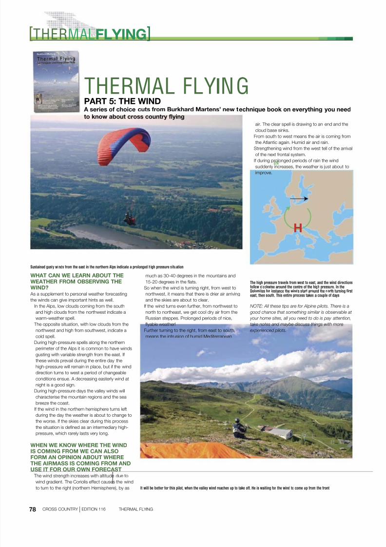
Sustained gusty winds from the east in the northern Alps indicate a prolonged high pressure situation
It will be better for this pilot, when the valley wind reaches up to take off. He is waiting for the wind to come up from the front
H
The high pressure travels from west to east, and the wind directions
follow clockwise around the centre of the high pressure. In the Dolomites for instance the winds start around the north turning first
east, then south. This entire process takes a couple of days
8/12/2019 Thermal Flying snippet
http://slidepdf.com/reader/full/thermal-flying-snippet 9/12
8/12/2019 Thermal Flying snippet
http://slidepdf.com/reader/full/thermal-flying-snippet 10/12
8/12/2019 Thermal Flying snippet
http://slidepdf.com/reader/full/thermal-flying-snippet 11/12
8/12/2019 Thermal Flying snippet
http://slidepdf.com/reader/full/thermal-flying-snippet 12/12