this report summarises the - new forest national park
TRANSCRIPT

This report summarises the European site interest features for the New Forest’s
internationally designated conservation sites which are the New Forest Special Protection
Area (SPA), the New Forest Special Area of Conservation (SAC) and the New Forest Ramsar
site. It considers the impacts of recreation on these features and the potential for mitigation.
The report has been commissioned by Test Valley Borough Council on behalf of a partnership
which also includes Eastleigh Borough Council, New Forest District Council, The New Forest
National Park Authority, Southampton City Council and Wiltshire Council.
There are many benefits of recreation, including health and well-being and connectedness to
nature. However, there are also potential impacts on the environment. These can
summarised under the following broad headings:
• Disturbance (avoidance of breeding habitat, physiological impacts, reduced
breeding success);
• Fire (resulting in direct mortality, removal of breeding habitat, long term changes
to vegetation structure);
• Contamination (including litter; nutrient enrichment through dog fouling; pollution
from dogs entering water courses; spread of alien species and pathogens;
greywater from campervans, etc);
• Trampling/wear (soil compaction, erosion, direct damage to breeding or wintering
sites, expansion of path networks, churning up sediment in water bodies);
• Harvesting (e.g. collection of wood, fungi);
• Grazing issues (impacts on grazing animals, e.g. from feeding, worrying by dogs,
open gates, road traffic accidents)
• Visitor expectation including pressure for facilities and public perceptions of
management resulting in difficulties achieving necessary habitat and species
protection.
Issues associated with recreation in the New Forest have long been a cause for concern, and
some Local Planning Authorities have implemented detailed mitigation strategies. However,
the challenge to balance recreation provision with conservation management and protection
of the European site interest continues to grow. Increases in housing around the
SAC/SPA/Ramsar site in the coming years will exacerbate the issues and result in a marked
increase in use. The pressure is particularly around the periphery of the SAC/SPA/Ramsar site.
Working with the steering group, we have listed and reviewed a range of mitigation options.
These are aligned with some of the strategic actions identified to in the recent update to the
New Forest National Park Recreation Management Strategy 2010-2030. The options fall under
the following broad headings:

• Alternative recreational greenspace sites and routes outside the New Forest
SAC/SPA/Ramsar;
• Access management within the New Forest SAC/SPA/Ramsar;
• Educational and communications activities, both within and outside the New
Forest SAC/SPA/Ramsar;
• Monitoring; and
• Other (siting of development to avoid/reduce impacts).
Together, the measures identified could form a ‘package’ of avoidance and mitigation
measures that should resolve the cumulative impacts from recreation associated with
housing growth around the New Forest. Such a package should enable Local Authorities to be
able to rule out adverse effects on integrity to the New Forest SAC/SPA/Ramsar as a result of
increased recreation associated with Local Plans. The measures will however not necessarily
be easy to establish and will require significant impetus to achieve. Given the broad
geographic scope and need for measures to dovetail, it will be important that there is a
strategic, proportionate and co-ordinated approach, which will require partnership working
across a range of local authorities and stakeholders.
The alignment with the update to the Recreation Management Strategy is important as
mitigation measures to resolve impacts from new housing will need to fit with existing
recreation management approaches and intended future management within the New Forest;
indeed, one of the strategic actions in the Strategy is to ‘Develop a coordinated approach among
planning authorities in and around the New Forest to mitigate the impacts of new housing on
protected areas’. The mitigation measures will however represent a legal obligation by which
local planning authorities ensure compliance with the relevant legislation.
Heathland breeding species ....................................................................................................... 10
Breeding raptors ......................................................................................................................... 13
Hen Harrier .................................................................................................................................. 13
Wood Warbler .............................................................................................................................. 13
Breeding waders .......................................................................................................................... 16
SAC habitats ................................................................................................................................. 18
SAC species ................................................................................................................................... 23
Species .......................................................................................................................................... 26
General principles ....................................................................................................................... 31
Impacts ......................................................................................................................................... 31
Types of access ............................................................................................................................ 32
Identifying vulnerable species .................................................................................................... 33
Legislative context ....................................................................................................................... 52

Wider context ............................................................................................................................... 53
Existing recreation management measures and HRA findings ............................................. 54
Benefits of a strategic approach ............................................................................................... 55
Insights from the survey results................................................................................................. 59
Insights from the survey results................................................................................................. 64
Insights from the survey results................................................................................................. 74
Insights from the survey results................................................................................................. 75
This report was commissioned by Test Valley Borough Council on behalf of a number of different local
authorities. We are grateful to Karen Eastley (Test Valley Borough Council) for overseeing the work and
our thanks to other members of the steering group that included: Richard Burke (Forestry
Commission), Adam Egglesfield (Hampshire County Council), Louise Evans (New Forest District Council),
David Illsley (New Forest National Park Authority), Dawn Heppell (Eastleigh Borough Council and
Southampton City Council), Louisa Kilgallen (Wiltshire Council), Nigel Matthews (New Forest National
Park Authority), Graham Smith (Test Valley Borough Council) and Nick Squirrell (Natural England).
Our thanks to Keith Betton (Hampshire Ornithological Society) for the provision of bird data. The
habitat GIS data were provided by Forestry England and we are grateful to Leanne Sargeant and Lisa
Macher for sharing the data. We are very grateful to a range of people for very helpful discussion and
provision of background information, including Keith Betton (Hampshire Ornithological Society), Clive
Chatters, Tony Davis, Nigel Matthews (New Forest National Park Authority), Lord Willie Manners and
Leanne Sargeant (Forestry England). We also draw on information from discussions and contributions
from a wide range of people involved in a workshop in Brockenhurst in July 2019. Our thanks to all who
attended and contributed to the discussions on a very warm afternoon.
This report, commissioned by a partnership of local authorities with funding from
central government, is part of a series that relates to understanding the impacts of
recreation (arising from new housing development) on the New Forest
international nature conservation designations. The various studies are intended
to inform necessary mitigation approaches.
In this report we summarise information on the interest features of the relevant
conservation designations, consider the potential impacts of recreation and
consider the potential options for avoidance and mitigation.
The designation, protection and restoration of key wildlife sites is embedded in the
Conservation of Habitats and Species Regulations 2017 (as amended), which are
commonly referred to as the ‘Habitats Regulations.’ These Regulations are in place
to transpose European legislation set out within the Habitats Directive (Council
Directive 92/43/EEC), which affords protection to plants, animals and habitats that
are rare or vulnerable in a European context, and the Birds Directive (Council
Directive 2009/147/EC), which originally came into force in 1979, and which
protects rare and vulnerable birds and their habitats. These key pieces of
European legislation seek to protect, conserve and restore habitats and species
that are of utmost conservation importance and concern across Europe. European
sites include Special Areas of Conservation (SACs) designated under the Habitats
Directive and Special Protection Areas (SPAs) classified under the Birds Directive.
Ramsar sites, those wetlands of international importance that are listed in the
Ramsar Convention are, through government policy, are also treated as European
sites.
Public bodies, including local planning authorities, have specific duties in terms of
avoiding deterioration of habitats and species for which sites are designated or
classified, and stringent tests have to be met before plans and projects can be
permitted. Importantly, the combined effects of individual plans or projects must
be taken into account. For local planning authorities, this means that the combined
effect of individual development proposals needs to be assessed collectively for
their cumulative impact, as well as on an individual basis.
The New Forest is one of the largest tracts of semi natural vegetation in the
country, and as such is one of our most important wildlife sites. The area hosts
three international wildlife site designations and is closely located to other
international wildlife sites such as the Solent and Southampton Water.
The New Forest is classified as an SPA for its breeding and overwintering bird
species of European importance, in accordance with the European Birds Directive.
The designation relates to internationally significant breeding populations of
Dartford Warbler Sylvia undata, Nightjar Caprimulgus europaeus, Woodlark Lullula
arborea, Honey Buzzard Pernis apivorus, Hobby Falco subbuteo and Wood Warbler
Phylloscopus sibilatrix and over-wintering Hen Harrier Circus cyaneus.
The New Forest is also designated as an SAC for its habitats and non-avian species
of European importance, in accordance with the European Habitats Directive. This
designation reflects the unique mosaic of habitats across the New Forest, which
includes eight Annex 1 heathland, grassland, woodland, wetland, bog and open
water habitats, together with three Annex 2 species, Stag Beetle Lucanus cervus,
and Southern Damselfly Coenagrion mercuriale, and Great Crested Newt Triturus
cristatus.
Also relevant is the New Forest’s listing as a Ramsar site, under the Ramsar
Convention. This recognises the international importance of the site as a wetland,
supporting wetland flora and fauna of international importance, and adding to the
global network of Ramsar listed wetlands.
A challenging issue for UK nature conservation is how to respond to increasing
demand for access without compromising the integrity of protected wildlife sites.
Areas that are important for nature conservation are often important for a range
of other services, including the provision of space for recreation for an increasing
population. Such recreation space can be used for a wide variety of activities,
ranging from the daily dog walks to competitive adventure and endurance sports.
There is now a strong body of evidence showing how increasing levels of access
can have negative impacts on wildlife. Visits to the natural environment have
shown a significant increase in England as a result of the increase in population
and a trend to visit more (O’Neill, 2019). The issues are particularly acute in
southern England, where population density is highest. Issues are varied and
include disturbance, increased fire risk, contamination and damage (for general

reviews see: Liley et al., 2010; Lowen, Liley, Underhill-Day, & Whitehouse, 2008;
Ross et al., 2014; Underhill-Day, 2005).
The issues are not however straightforward. It is now increasingly recognised that
access to the countryside is crucial to the long term success of nature conservation
projects, for example through enforcing pro-environmental behaviours and a
greater respect for the world around us (Richardson, Cormack, McRobert, &
Underhill, 2016). Access also brings wider benefits to society that include benefits
to mental/physical health (Keniger, Gaston, Irvine, & Fuller, 2013; Lee &
Maheswaran, 2011; Pretty et al., 2005) and economic benefits (ICF GHK, 2013; ICRT,
2011; Keniger et al., 2013; The Land Trust, 2018). Nature conservation bodies are
trying to encourage people to spend more time outside and government policy is
also promoting countryside access in general (e.g. through enhancing coastal
access).
There are two statutory purposes for national parks in England and Wales. The
first is to conserve and enhance natural beauty, wildlife and cultural heritage and
the second is to promote opportunities for the understanding and enjoyment of
the special qualities of national parks by the public. This second purpose includes
opportunities for open air recreation. However, if it appears that there is a conflict
between the two National Park purposes, the Environment Act 1995 requires
greater weight to be attached to the purpose of conserving and enhancing the
natural beauty, wildlife and cultural heritage of the National Park (this is known as
the Sandford Principle1). When national parks carry out these purposes, they also
have the duty to encourage the social and economic well-being of local
communities within the national park.
There is therefore, a significant challenge: to avoid or mitigate potential negative
impacts associated with recreation so as to comply with legislation without
compromising the ability of people to be outside enjoying sites for recreation.
This report has been commissioned to summarise the European site interest
features and review the various pathways and mechanisms by which recreation
may impact them. These findings then lead to consideration of the implications in
terms of mitigation or avoidance measures. This provides context for the visitor
survey work conducted in parallel (see and will provide the basis for future
appropriate assessment and consideration of future approaches to resolve issues
associated with recreation pressure from new housing.
1 Named after Lord Sandford, who chaired the 1974 National Parks Policy Review Committee.

The work forms part of a series of reports that relates to understanding the
impacts of new development on the New Forest international nature conservation
designations. The project as a whole involves visitor surveys combined with work
to understand the impacts of recreation and relevant mitigation approaches.
Other reports, produced in parallel with this one, include:
• Recreation use of the New Forest SAC/SPA/Ramsar: New Forest
visitor survey 2018/19 - results of on-site face-face interviews with
visitors conducted at formal car parks and other locations across the
New Forest SAC/SPA/Ramsar;
• Recreation use of the New Forest SAC/SPA/Ramsar: New Forest
vehicle counts 2018/19 – results of vehicle counts across the New Forest
SAC/SPA/Ramsar car parks, counting all parked vehicles on a range of
different dates over a year;
• Recreation use of the New Forest SAC/SPA/Ramsar: Results of a
telephone survey with people living within 25km - the results of a
telephone survey with 2,000 residents living within a 25km radius of the
woodland/heathland areas of the New Forest SAC/SPA/Ramsar;
• Recreation use of the New Forest SAC/SPA/Ramsar: Overview of
visitor results and implications of housing change on visitor
numbers - a summary of the visitor survey results, drawing the findings
from the telephone survey, on-site survey and vehicle counts together
and making predictions for change in recreation as a result of new
housing.

The SPA qualified for designation under Article 4.1 of the Birds Directive as it is
used regularly by 1% or more of the Great Britain population of three heathland
species (Dartford Warbler Sylvia undata, Woodlark Lullula arborea and Nightjar
Caprimulgus europaeus) and Honey Buzzard Pernis apivorus (all breeding) and Hen
Harrier Circus cyaneus (wintering). The SPA also qualifies under Article 4.2 for
breeding Hobby Falco subbuteo and Wood Warbler Phylloscopus sibilatrix. While not
qualifying species, the SPA citation also highlights the notable populations of
breeding waders and breeding Redstart Phoenicurus phoenicurus.
Heathland breeding species
At the time of classification (in 1992), the SPA supported 300 Nightjar territories
(estimated to be at least 15% of the UK population at the time); 51-54 pairs of
Woodlarks (24% of the UK population) and 454 pairs of Dartford Warblers (75% of
the UK population).
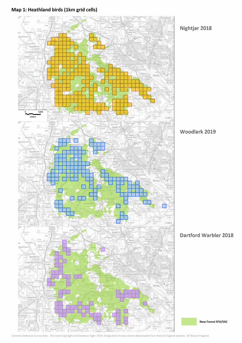
Bird counts over time are summarised by the National Park Authority (2016) and
recent surveys (undertaken by the Hampshire Ornithological Society HOS) have
been commissioned by the Verderers as part of the Higher Level Stewardship
Agreement. Plots showing changes in bird numbers for the three species over time
are shown in Figure 1, and Map 1 shows recent distribution (occupied km squares).
These counts indicate that numbers of all three species have previously been
higher and in the case of Nightjar and Dartford Warbler, a decline is evident.
The 2018 survey (Jackson, 2018) showed a decline in the number of Nightjar
compared to 2004/5 and to 2013, with a reduction in the number of territories
across the whole of the New Forest. The results from the 2018 survey of Dartford
Warblers (Clements, 2019) suggests numbers were at an all-time low, albeit after
two spells of severe cold weather late in the winter. However, the data for
population changes for these three species do not mirror those of nearby Dorset
heathland sites (Liley & Fearnley, 2014; Panter & Caals, in prep). For example,
Dartford Warbler numbers remained broadly stable over the period 1990 -2009
across the Dorset Heaths as a whole (Liley & Fearnley, 2014) and Nightjar numbers
have increased at multiple sites in recent years (Panter & Caals, in prep).
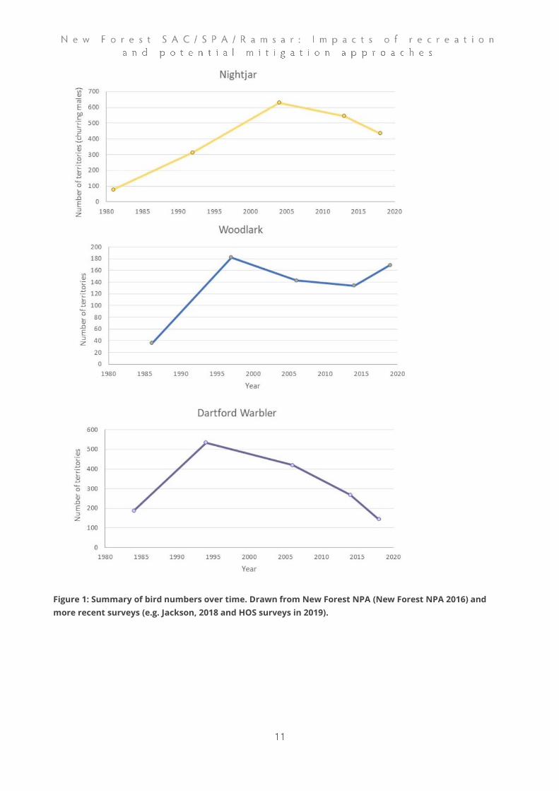
Figure 1: Summary of bird numbers over time. Drawn from New Forest NPA (New Forest NPA 2016) and
more recent surveys (e.g. Jackson, 2018 and HOS surveys in 2019).

Breeding raptors
Both Honey Buzzard and Hobby have exhibited large national range expansions
and population increases (the latter +144% and +133%, respectively) over the 25
years up to 2016 (Holling & Rare Breeding Birds Panel, 2018), with the New Forest
comprising a key site historically for both species. The Honey Buzzard population
within the New Forest SAC/SPA/Ramsar has remained stable (or possibly slightly
increased) since the classification of the SPA (at classification the site supported 2
pairs, around 7% of the UK population), with high levels of productivity also
recorded (Hampshire Ornithological Society, 2015a). There were thought to be 4-5
pairs in 2019 (Betton pers. comm.).
Contrastingly, and despite having a sizeable and healthy population across
Hampshire as a whole, there are indications of a decline in the New Forest Hobby
population (Hampshire Ornithological Society, 2015a), potentially linked to changes
in prey availability and colonisation by predatory Goshawk Accipiter gentilis. At
classification the SPA was estimated to support 25 pairs of Hobby (3% of the UK
population), while the conservation objectives (supplementary advice) suggests a
total of just 6 pairs in 20162. More recently the breeding totals are perhaps around
4 pairs (Hampshire Ornithological Society, 2018).
Hen Harrier
Hen Harriers are only present within the New Forest SAC/SPA/Ramsar as winter
visitors, during which the species uses communal roosts at traditional localities.
The winter distribution of the species across Hampshire as a whole has increased
in recent decades, although the number of individuals recorded has continued to
decline (Hampshire Ornithological Society, 2015a) and numbers using the New
Forest SAC/SPA/Ramsar during the winter are now very low, with just lone birds
recorded in recent winters (Keith Betton pers. comm.). There has been a continuing
downward annual trend in the number of wintering individuals between 2013 and
2015 (Hampshire Ornithological Society, 2015b, 2015c, 2016). The New Forest
however still has the greatest density of records of this scarce and declining winter
visitor within the county (Hampshire Ornithological Society, 2015a).
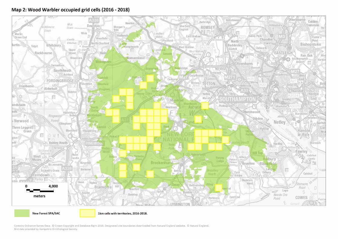
Wood Warbler
Within Hampshire, breeding Wood Warbler is now confined to the New Forest
(Hampshire Ornithological Society, 2015a), with the breeding range of the species
within the county declining by 76% between 1986 - 1991 and 2007 - 2012.
2 Natural England: European Site Conservation Objectives: Supplementary advice on conserving and
restoring site features - New Forest Special Protection Area (SPA) Site code: UK9011031

Numbers within the New Forest itself have continued to decrease, in line with a
well-documented national range contraction and population decline (Balmer et al.,
2013) and the species is in real danger of becoming extinct as a breeding species
within the next few years within the New Forest (T. Davis, pers comm.). Comparison
of breeding populations in Wales (a relatively stable population), Devon (a
declining population) and the New Forest (declining population) found high rates
of nest predation for the New Forest, but not at the Devon site (P. Bellamy, 2015; P.
E. Bellamy et al., 2018). There is a suggestion that demographics in other parts of
their breeding range or in their wintering areas are likely reasons for local
population declines (P. Bellamy, 2015; Mallord, Smith, Bellamy, Charman, &
Gregory, 2016).
Breeding waders
Breeding waders are not an interest feature of the SPA but are mentioned in the
SPA citation. They are a distinctive and notable feature of the New Forest. Key
species are Lapwing Vanellus vanellus, Snipe Gallinago gallinago, Curlew Numenius
arquata and Redshank Tringa totanus. There have been very marked declines over
the last two decades and possibly longer (e.g. Goater, Houghton, & Temple, 2004;
HOS, 2019; Wyn & Page, 2018). Recent estimates for the New Forest for 2019 (HOS,
2019) are for around 40 pairs of Curlew, 48 pairs of Lapwing and just 7 Redshank
territories. The most recent data for Snipe were 102 drumming males in 2014 (RPS,
2014). Recent distribution data from the period 2016-18, provided by the
Hampshire Ornithological Society are summarised in Map 3.


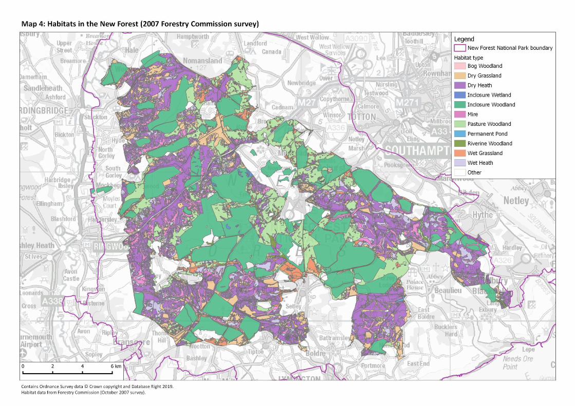
SAC habitats
The New Forest SAC is unique in the extent and natural dynamism of its semi-
natural habitats. It is characterised by a fluctuating mosaic of habitat types that
were once common across lowland western Europe but are now generally highly
fragmented. Woodlands include ancient wood pasture, inclosure woodland and
smaller areas of riverine woodland and bog woodland. Heathlands comprise
extensive dry and wet heaths intersected by valley mires and streams with pools,
temporary ponds and dry and wet grassland. Thirteen Annex I habitats are
represented, included two priority habitats. Veteran trees and dead wood mean
the New Forest SAC is of exceptional importance for its saprophytic invertebrate
fauna and lichen and bryophyte flora while the heathlands, grasslands and
wetlands support vegetation communities and species reflective of the long
continuous history of livestock grazing. Habitats are listed and described in Table
1. Map 4 shows the habitat data.
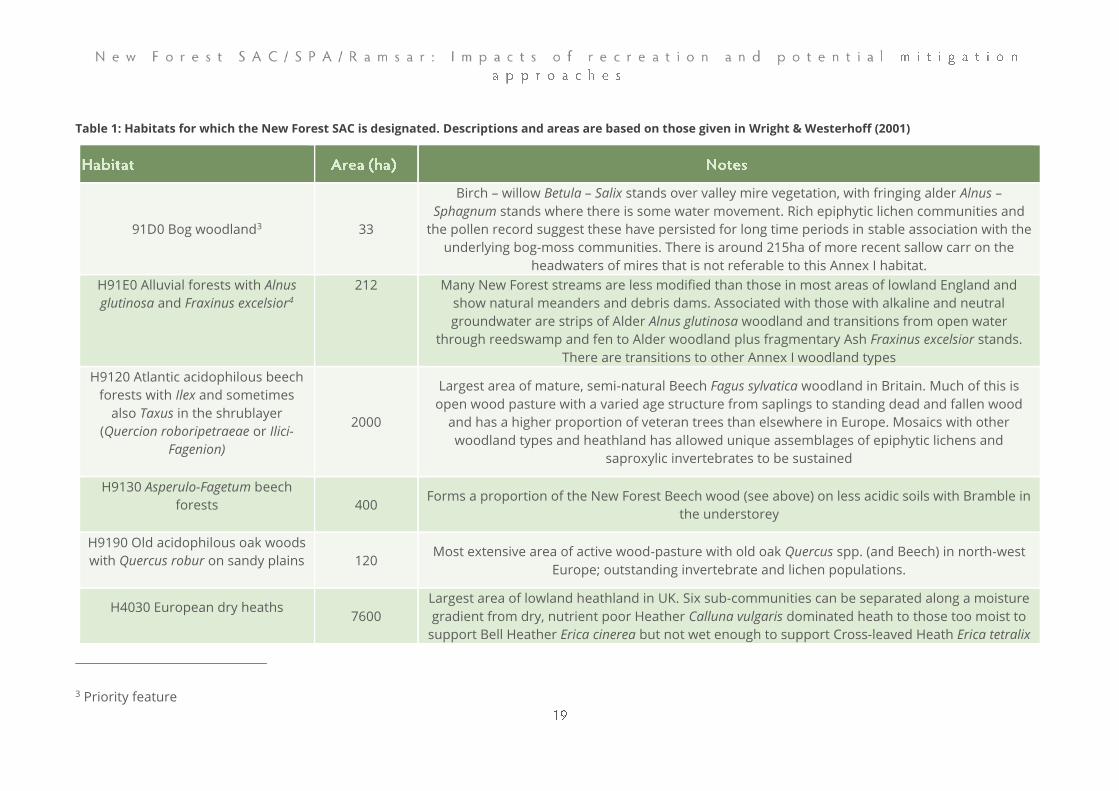
Table 1: Habitats for which the New Forest SAC is designated. Descriptions and areas are based on those given in Wright & Westerhoff (2001)
91D0 Bog woodland3 33
Birch – willow Betula – Salix stands over valley mire vegetation, with fringing alder Alnus –
Sphagnum stands where there is some water movement. Rich epiphytic lichen communities and
the pollen record suggest these have persisted for long time periods in stable association with the
underlying bog-moss communities. There is around 215ha of more recent sallow carr on the
headwaters of mires that is not referable to this Annex I habitat.
H91E0 Alluvial forests with Alnus
glutinosa and Fraxinus excelsior4
212 Many New Forest streams are less modified than those in most areas of lowland England and
show natural meanders and debris dams. Associated with those with alkaline and neutral
groundwater are strips of Alder Alnus glutinosa woodland and transitions from open water
through reedswamp and fen to Alder woodland plus fragmentary Ash Fraxinus excelsior stands.
There are transitions to other Annex I woodland types
H9120 Atlantic acidophilous beech
forests with Ilex and sometimes
also Taxus in the shrublayer
(Quercion roboripetraeae or Ilici-
Fagenion)
2000
Largest area of mature, semi-natural Beech Fagus sylvatica woodland in Britain. Much of this is
open wood pasture with a varied age structure from saplings to standing dead and fallen wood
and has a higher proportion of veteran trees than elsewhere in Europe. Mosaics with other
woodland types and heathland has allowed unique assemblages of epiphytic lichens and
saproxylic invertebrates to be sustained
H9130 Asperulo-Fagetum beech
forests
400 Forms a proportion of the New Forest Beech wood (see above) on less acidic soils with Bramble in
the understorey
H9190 Old acidophilous oak woods
with Quercus robur on sandy plains
120 Most extensive area of active wood-pasture with old oak Quercus spp. (and Beech) in north-west
Europe; outstanding invertebrate and lichen populations.
H4030 European dry heaths
7600
Largest area of lowland heathland in UK. Six sub-communities can be separated along a moisture
gradient from dry, nutrient poor Heather Calluna vulgaris dominated heath to those too moist to
support Bell Heather Erica cinerea but not wet enough to support Cross-leaved Heath Erica tetralix
3 Priority feature
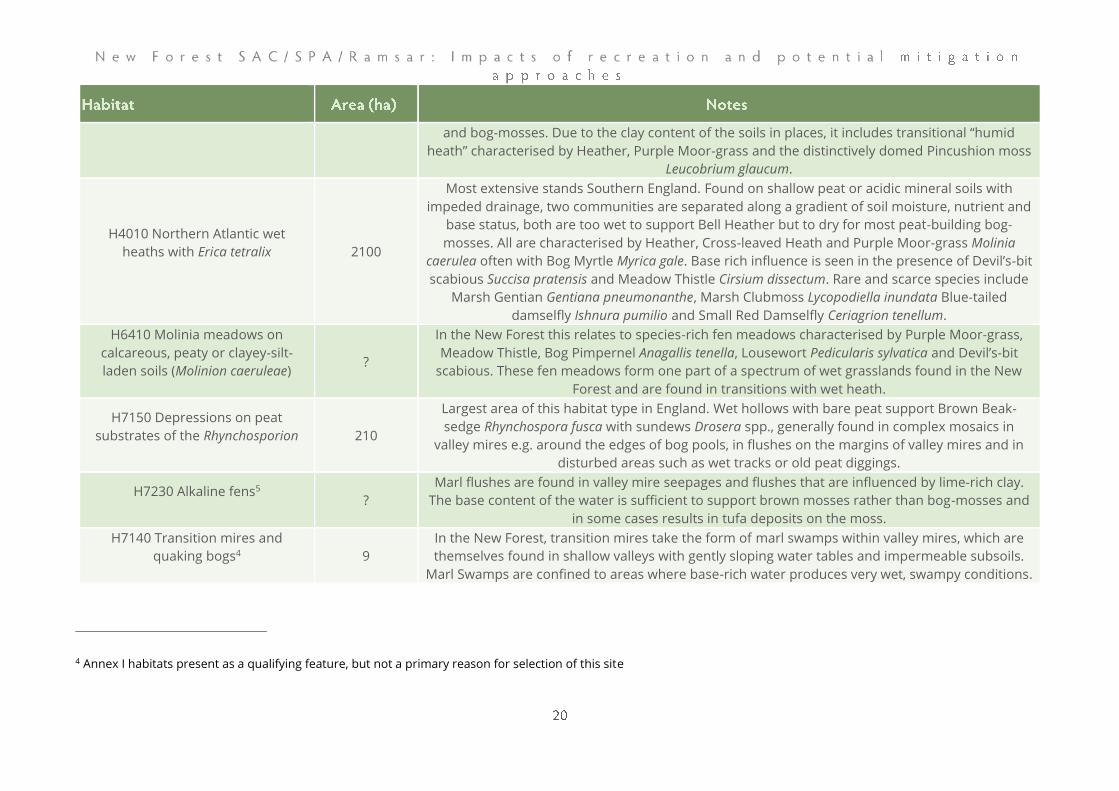
and bog-mosses. Due to the clay content of the soils in places, it includes transitional “humid
heath” characterised by Heather, Purple Moor-grass and the distinctively domed Pincushion moss
Leucobrium glaucum.
H4010 Northern Atlantic wet
heaths with Erica tetralix
2100
Most extensive stands Southern England. Found on shallow peat or acidic mineral soils with
impeded drainage, two communities are separated along a gradient of soil moisture, nutrient and
base status, both are too wet to support Bell Heather but to dry for most peat-building bog-
mosses. All are characterised by Heather, Cross-leaved Heath and Purple Moor-grass Molinia
caerulea often with Bog Myrtle Myrica gale. Base rich influence is seen in the presence of Devil’s-bit
scabious Succisa pratensis and Meadow Thistle Cirsium dissectum. Rare and scarce species include
Marsh Gentian Gentiana pneumonanthe, Marsh Clubmoss Lycopodiella inundata Blue-tailed
damselfly Ishnura pumilio and Small Red Damselfly Ceriagrion tenellum.
H6410 Molinia meadows on
calcareous, peaty or clayey-silt-
laden soils (Molinion caeruleae)
?
In the New Forest this relates to species-rich fen meadows characterised by Purple Moor-grass,
Meadow Thistle, Bog Pimpernel Anagallis tenella, Lousewort Pedicularis sylvatica and Devil’s-bit
scabious. These fen meadows form one part of a spectrum of wet grasslands found in the New
Forest and are found in transitions with wet heath.
H7150 Depressions on peat
substrates of the Rhynchosporion
210
Largest area of this habitat type in England. Wet hollows with bare peat support Brown Beak-
sedge Rhynchospora fusca with sundews Drosera spp., generally found in complex mosaics in
valley mires e.g. around the edges of bog pools, in flushes on the margins of valley mires and in
disturbed areas such as wet tracks or old peat diggings.
H7230 Alkaline fens5
?
Marl flushes are found in valley mire seepages and flushes that are influenced by lime-rich clay.
The base content of the water is sufficient to support brown mosses rather than bog-mosses and
in some cases results in tufa deposits on the moss.
H7140 Transition mires and
quaking bogs4
9
In the New Forest, transition mires take the form of marl swamps within valley mires, which are
themselves found in shallow valleys with gently sloping water tables and impermeable subsoils.
Marl Swamps are confined to areas where base-rich water produces very wet, swampy conditions.
4 Annex I habitats present as a qualifying feature, but not a primary reason for selection of this site
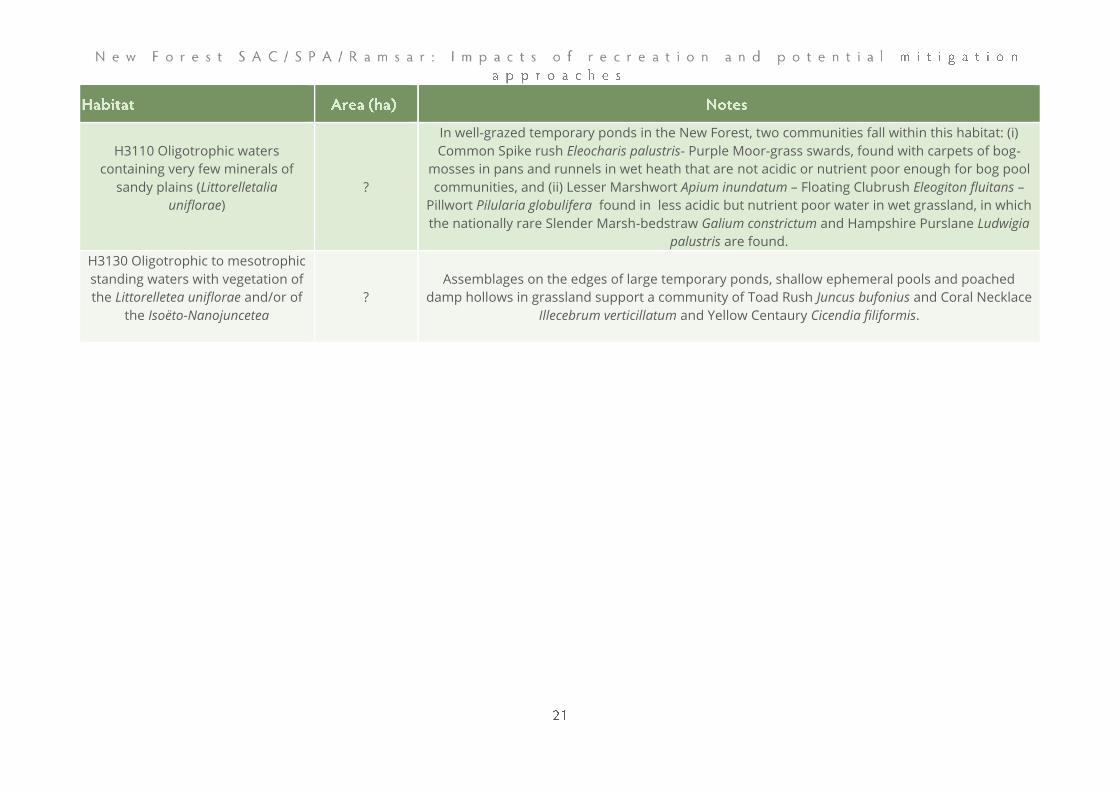
H3110 Oligotrophic waters
containing very few minerals of
sandy plains (Littorelletalia
uniflorae)
?
In well-grazed temporary ponds in the New Forest, two communities fall within this habitat: (i)
Common Spike rush Eleocharis palustris- Purple Moor-grass swards, found with carpets of bog-
mosses in pans and runnels in wet heath that are not acidic or nutrient poor enough for bog pool
communities, and (ii) Lesser Marshwort Apium inundatum – Floating Clubrush Eleogiton fluitans –
Pillwort Pilularia globulifera found in less acidic but nutrient poor water in wet grassland, in which
the nationally rare Slender Marsh-bedstraw Galium constrictum and Hampshire Purslane Ludwigia
palustris are found.
H3130 Oligotrophic to mesotrophic
standing waters with vegetation of
the Littorelletea uniflorae and/or of
the Isoëto-Nanojuncetea
?
Assemblages on the edges of large temporary ponds, shallow ephemeral pools and poached
damp hollows in grassland support a community of Toad Rush Juncus bufonius and Coral Necklace
Illecebrum verticillatum and Yellow Centaury Cicendia filiformis.

SAC species
Two species on Annex II of the Habitats Directive are primary features of the site:
Great Crested Newt is also a qualifying feature of the site, but not a primary reason
for its designation.
Stag Beetles require broad-leaved tree stumps, or fallen trees in contact with the
ground, within which their larvae can develop over a period of 3 to 4 years. They
are the largest, and arguably the most spectacular, of the terrestrial British
Coleoptera, and the New Forest SAC comprises a key stronghold for the species
within the UK (and forms a core unit within the species’ main Hampshire/Sussex
population centre). The New Forest SAC as a whole has been recognised for its
importance to saproxylic invertebrate species, including species such as the Stag
Beetle. A summary of the species’ distribution across the New Forest (data from
1999 onwards) are shown in Map 5.
Great Crested Newts are present in a large number of ponds, primarily distributed
around the perimeter of the New Forest SAC. The species uses these freshwater
habitats during the breeding season, with eggs laid amongst aquatic vegetation in
the early spring and the resulting juveniles emerging from the breeding ponds in
late summer/early autumn, following an aquatic development phase. Both adult
and juvenile newts spend extended periods living and foraging within terrestrial
environments, and the availability of suitable terrestrial habitat (as well as
breeding sites) is therefore of key importance for the species.
Southern Damselflies are widespread across the New Forest SAC, which is the
major population centre for the species in Britain, with nearly 20 populations and
1,800 males recorded in 2015/16 (Panter, Lake & Liley 2016). Distribution data
(from Panter, Lake & Liley) are summarised in Map 5. It is found in shallow, well-
vegetated, base-rich funnels and flushes with gently flowing, well-oxygenated
water on wet heaths or in valley mires. Females lay eggs on submerged plants and
the larvae, which remain in the runnels, and take two years to mature. The species
is therefore susceptible to drought, freezing and deterioration in water quality. The
UK population is thought to be a major European stronghold of the species.
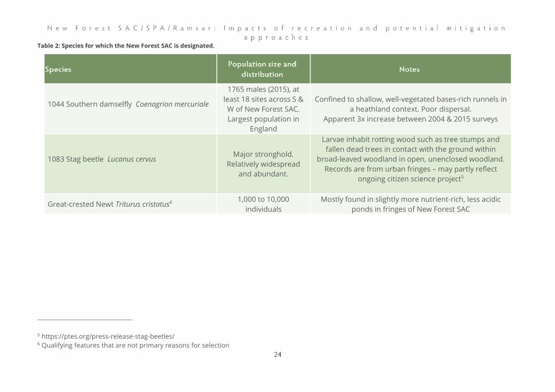
Table 2: Species for which the New Forest SAC is designated.
1044 Southern damselfly Coenagrion mercuriale
1765 males (2015), at
least 18 sites across S &
W of New Forest SAC.
Largest population in
England
Confined to shallow, well-vegetated bases-rich runnels in
a heathland context. Poor dispersal.
Apparent 3x increase between 2004 & 2015 surveys
1083 Stag beetle Lucanus cervus
Major stronghold.
Relatively widespread
and abundant.
Larvae inhabit rotting wood such as tree stumps and
fallen dead trees in contact with the ground within
broad-leaved woodland in open, unenclosed woodland.
Records are from urban fringes – may partly reflect
ongoing citizen science project5
Great-crested Newt Triturus cristatus6 1,000 to 10,000
individuals
Mostly found in slightly more nutrient-rich, less acidic
ponds in fringes of New Forest SAC
5 https://ptes.org/press-release-stag-beetles/ 6 Qualifying features that are not primary reasons for selection

The New Forest Ramsar site is described as complex, with examples of semi-
natural habitats essential to the genetic and ecological diversity of southern
England.
Habitat features of the New Forest Ramsar overlap with the SAC (see Table 1) and
are therefore not described again here.
Species
Overlap between SPA, SAC and Ramsar site designated features include the
nationally important breeding population of Dartford Warbler and wintering
population of Hen Harrier, and internationally important populations of both
Southern Damselfly and Stag Beetle (see SPA and SAC information above).
Additional nationally important species recorded from the site include Great
Crested Newt, Bullhead Cottus gobio, and Brook Lamprey Lampetra planeri.
The site is of particular importance for its rare invertebrate assemblage, with 159
Red Data Book species listed on the site’s citation, in addition to a further 21 non-
designated habitat specialists. Several of the species listed (e.g. Arctosa fulvolineata;
a wolf spider species) are saltmarsh specialists associated with coastal habitats on
the periphery of the New Forest Ramsar. Nevertheless, the majority of the species
listed specialise upon, or are primarily associated with, the New Forest’s heathland,
broad-leaved woodland (including dead wood and veteran tree micro-habitats),
and wetland habitats.
The 159 species listed can largely be categorised by the habitat/s within which they
specialise. These key habitat types are provided below, along with examples of the
Red Data Book invertebrate species they support:
• Heathland/heather specialists (e.g. Heath Grasshopper Chorthippus
vagans, Shoulder-striped Clover Heliothis maritima (a moth), Coniocleonus
nebulosus (a weevil), Mottled Bee-fly Thyridanthrax fenestratus, and
Halpodrassus umbratilis (a spider));
• Established broad-leaved woodland/saproxylic species (e.g. Euplectus
punctatus (a short-winged mould beetle), Procraerus tibialis (a click beetle),
The Triangle Heterogenea asella (a moth), and Pocota personata (a hoverfly));
• Bog and mire specialists (e.g. Large Marsh Grasshopper Stethophyma
grossum, Sundew Plume Buckleria paludum (a moth), Pachybrachius luridus (a
ground bug), and Bagous frit (a sloth weevil)), and;
• Wetland, pool, and stream specialists (e.g. Medicinal Leech Hirudo
medicinalis, Donacia bicolora (a leaf beetle), and Agabus brunneus (a water
beetle)).
The noteworthy flora within the Ramsar sites includes several species. Many of
these are associated with disturbed, seasonally wet ground. They are listed here by
microhabitat (note some may be found in more than one):
• Wet valley mire & bog pool species: Bog Orchid Hammarbya paludosa,
Brown Beak-sedge Rhynchospora fusca, Slender Cottongrass Eriophorum
gracile Intermediate Bladderwort Utricularia intermedia,
• Species associated with damp bare ground (e.g. track ruts, seasonal
pools, winter-wet hollows): Marsh Clubmoss Lycopodiella inundata,
Yellow Centaury Cicendia filiformis, Three-lobed Water Crowfoot
Ranunculus tripartitus Mousetail Myosurus minimus, Pennyroyal Mentha
pulegium, Coral Necklace Illecebrum verticillatum, Brown Beak-sedge,
Small Fleabane Pulicaria vulgaris, Bog Hair-grass Deschampsia setacea,
Slender Marsh-bedstraw Galium constrictum (debile),
• Pond margins Hampshire-purslane Ludwigia palustris, Six-stamened
Waterwort Elatine hexandra, Needle spike-rush Eleocharis acicularis,
Pillwort Pilularia globulifera, Slender Marsh-bedstraw
• Wet heath species: Marsh Gentian Gentiana pneumonanthe
• Wet woodland (carr): Marsh Fern Thelypteris palustris
• New Forest lawns: Slender Marsh-bedstraw
• Other: Annual Beard-grass Polypogon monspeliensis (coastal grassland,
disturbed ground), Yellow Bartsia Parentucellia viscose (damp acid
grassland), Soft-leaved Sedge Carex montana (bracken/grass heath),
Dwarf spike-rush Eleocharis parvula (saltmarsh pans, brackish pool),
Corky-fruited water-dropwort Oenanthe pimpinelloides (meadows)
Touch-me-not-Balsam Impatiens noli-tangere is listed in the noteworthy flora but
has not been recorded since 1986 and is considered extinct in the New Forest
(Rand & Mundell, 2011).
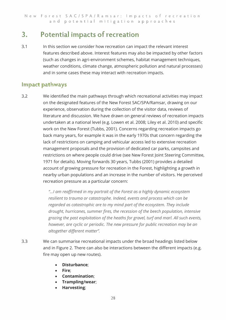
In this section we consider how recreation can impact the relevant interest
features described above. Interest features may also be impacted by other factors
(such as changes in agri-environment schemes, habitat management techniques,
weather conditions, climate change, atmospheric pollution and natural processes)
and in some cases these may interact with recreation impacts.
We identified the main pathways through which recreational activities may impact
on the designated features of the New Forest SAC/SPA/Ramsar, drawing on our
experience, observation during the collection of the visitor data, reviews of
literature and discussion. We have drawn on general reviews of recreation impacts
undertaken at a national level (e.g. Lowen et al. 2008; Liley et al. 2010) and specific
work on the New Forest (Tubbs, 2001). Concerns regarding recreation impacts go
back many years, for example it was in the early 1970s that concern regarding the
lack of restrictions on camping and vehicular access led to extensive recreation
management proposals and the provision of dedicated car parks, campsites and
restrictions on where people could drive (see New Forest Joint Steering Committee,
1971 for details). Moving forwards 30 years, Tubbs (2001) provides a detailed
account of growing pressure for recreation in the Forest, highlighting a growth in
nearby urban populations and an increase in the number of visitors. He perceived
recreation pressure as a particular concern:
“…I am reaffirmed in my portrait of the Forest as a highly dynamic ecosystem
resilient to trauma or catastrophe. Indeed, events and process which can be
regarded as catastrophic are to my mind part of the ecosystem. They include
drought, hurricanes, summer fires, the recession of the beech population, intensive
grazing the past exploitation of the heaths for gravel, turf and marl. All such events,
however, are cyclic or periodic. The new pressure for public recreation may be an
altogether different matter”.
We can summarise recreational impacts under the broad headings listed below
and in Figure 2. There can also be interactions between the different impacts (e.g.
fire may open up new routes).
• Disturbance;
• Fire;
• Contamination;
• Trampling/wear;
• Harvesting;

• Grazing issues
• Visitor expectation.
They are reviewed in a national context in various sources and a previous review
(Fearnley, Hoskin, Liley, White, & Lake, 2012) considered some of the issues from a
New Forest perspective. Here we summarise the activities involved in each
pathway and the conservation features likely to be impacted in the New Forest
SAC/SPA/Ramsar.
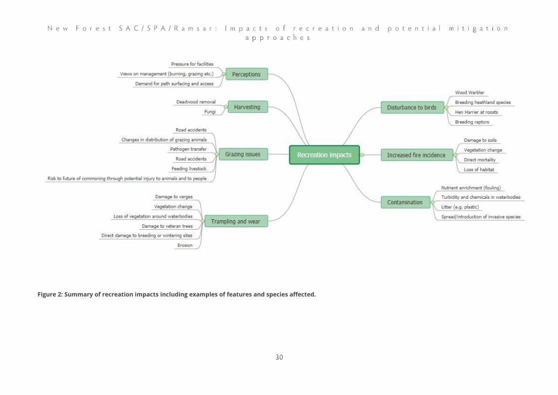
Figure 2: Summary of recreation impacts including examples of features and species affected.

Disturbance occurs where human activity influences an animal’s behaviour or
survival. By far the majority of the literature (and there are thousands of studies),
focuses on birds (Brawn, Robinson, & III, 2001; Hill et al., 1997; for general reviews
see Hockin et al., 1992; Lowen et al., 2008; Showler, 2010; Steven, Pickering, & Guy
Castley, 2011; Whitfield, Ruddock, & Bullman, 2008). Disturbance can also affect
mammals, herptiles (see Edgar, 2002 for review) and invertebrates.
General principles
The presence of people in the countryside will influence wildlife in many ways. For
many species, the people or their pets (e.g. dogs) are a potential threat and as
such it is to be expected that the response will be to modify behaviour, for
example fleeing. The relative trade-off as to when to change behaviour and
respond to the threat will relate to the perceived scale of the threat and the costs
involved (e.g. lost foraging time). This perspective can be used to understand the
behavioural responses to people and led one author to describe human
disturbance as predation-free predators (Beale & Monaghan, 2004).
With people (and their pets) viewed as potential predators, there is clearly a
greater threat posed (and therefore a greater behavioural response) when, for
example, there are more people, in larger groups (Beale & Monaghan, 2004, 2005)
or when people approach directly (Smith-Castro & Rodewald, 2010) or faster
(Bellefleur, Lee, & Ronconi, 2009).
The presence of people may also draw particular predators, for example a study in
America showed the Crow (corvid) populations were centred around campgrounds
(Marzluff & Neatherlin, 2006) while Kays et al. (2017) used camera traps to show a
range of predators actively selected human-made paths. As such the presence of
people may also influence the distribution and abundance of predators with a
knock-on effect for potential prey species.
Impacts
Disturbance can therefore have a range of different impacts, potentially affecting
distribution, breeding success and health. Impacts can be chronic, for example
otherwise suitable nesting habitat being completely avoided (e.g. Liley &
Sutherland, 2007) or more short-term in nature, for example birds becoming alert
and then resuming the initial activity (e.g. Fernandez-Juricic, Jimenez, & Lucas,
2001). Birds might be temporarily displaced from particular locations and such
behavioural responses will have some energetic costs, even if only very short term
in duration. Impacts can also include indirect mortality, for example through
increased predation associated with disturbance (e.g. Brambilla, Rubolini, &
Guidali, 2004). There are also examples of direct predation by pet dogs, for
example dogs were recorded as predators of nests and incubating adult Ringed
Plovers Charadrius hiaticula on Lindisfarne (Pienkowski, 1984). Some studies have
shown evidence of accidental trampling of nests and young, including herptiles
(Edgar, 2002) and birds (Durwyn Liley & Sutherland, 2007). Much harder to
measure and record are physiological effects, for example related to stress, and
these may in turn affect fitness. While studies are limited, there is evidence of
physiological effects in terms of increased heart rate (Ellenberg, Mattern, &
Seddon, 2013) and stress-hormones (Thiel, Jenni-Eiermann, Palme, & Jenni, 2011).
As such the presence of people may affect birds and other wildlife in a range of
ways that are not always easy to measure or record. Many people simply assume
disturbance to relate to birds taking flight or fleeing, but in reality these
behavioural responses are likely to be only part of a much wider picture.
Types of access
Disturbance has been shown to occur with a range of different types of activities,
for example Steven et al. (2011), in their review of disturbance impacts to birds
listed the following activities and research findings:
• Standing/observing: 15 studies, 14 showing negative effects of
disturbance;
• Touring/walking/hiking: 51 studies, 45 showing negative effects of
disturbance;
• Running: 6 studies, 6 showing negative effects of disturbance
• Cycling/Mountain bike riding: 3 studies, 3 showing negative effects of
disturbance;
• Canoeing: 3 studies, 3 showing negative effects of disturbance;
• Dog walking: 11 studies, 11 showing negative effects of disturbance;
• Horse riding: 0 studies, 0 showing negative effects of disturbance.
More recent studies have highlighted emerging activities such as drones (Mulero-
Pázmány et al., 2017).
It is often difficult to separate different types of activities as at many sites multiple
activities tend to overlap in space and time. Nonetheless, dogs are often identified
as having a disproportionate effect (Banks & Bryant, 2007; Cavalli, Baladrón, Isacch,
Biondi, & Bó, 2016; Lafferty, 2001; D. Liley & Fearnley, 2012; Taylor, Green, &
Perrins, 2007; Thomas, Kvitek, & Bretz, 2003); dogs are likely to be perceived as a
greater threat (i.e. as a predator), will actively chase birds and are able to track
wildlife by smell.
Identifying vulnerable species
Virtually all bird species will respond negatively to the presence of people if
approached too closely and the conservation objectives (supplementary advice) for
the SPA recognise the risk of disturbance for each of the interest features.
In particular, we would highlight:
• Ground-nesting birds as nests will be vulnerable to trampling and chicks
to predation by dogs and there is a risk of flushing and predation
associated with disturbance;
• Breeding raptors as large birds tend to flush at bigger distances and
raptors can often be sensitive to people around the nest;
• Breeding birds of all relevant species are likely to avoid areas with high
levels of access;
• Hen Harriers at roost sites, as disturbance may cause displacement and
prevent birds from roosting;
• Very rare species, as there is a greater risk of local extinction for species
with small population sizes;
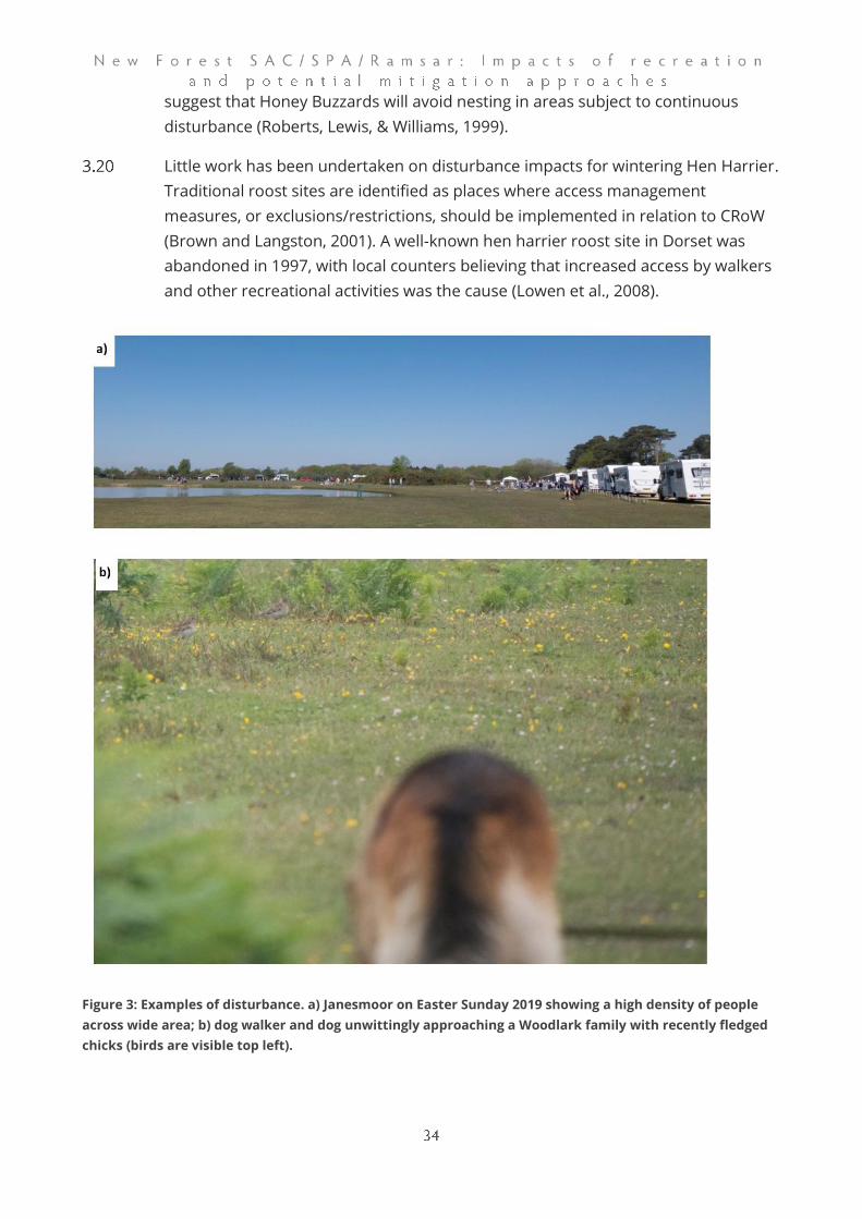
High levels of access (e.g. Figure 3a) will deter breeding birds and render otherwise
suitable habitat unavailable. For both Nightjar and Woodlark studies have shown
recreation use affects the distribution of birds within sites, such that busy areas
are avoided (Liley et al. 2006; Mallord et al. 2007; Lowe, Rogers & Durrant 2014).
For Dartford warblers, breeding productivity is lower in heather-dominated
territories where access levels are high (Murison et al. 2007), this is because
disturbed birds nest later in the season. For Nightjar there is also evidence of
breeding success being lower on busier sites and busier parts of sites (Murison
2002). For woodlarks (Figure 3b) at least, there are clear population-level impacts
as a result of the presence of people on the heaths (Mallord et al. 2007).
Previous analyses of predicted visitor distributions and heathland breeding bird
distributions in the New Forest SAC/SPA/Ramsar (Sharp, Lowen, & Liley, 2008)
found some evidence (particularly for Woodlark) that areas with high levels of
recreation use were avoided.
Wood Warblers are also ground nesting and can nest on banks, even those
alongside tracks (Tony Davis pers. comm.). Recreation impacts are however thought
to be relatively minor although nest monitoring in the New Forest has recorded
two nests predated by domestic dogs (Tony Davis pers comm.).
Disturbance is known to be an issue for Hobby when nesting and has been
associated with breeding failure, even on areas with limited public access
(Messenger & Roome, 2007). Breeding Honey Buzzards are widely considered
highly susceptible to disturbance, and although some authors contest this they still
suggest that Honey Buzzards will avoid nesting in areas subject to continuous
disturbance (Roberts, Lewis, & Williams, 1999).
Little work has been undertaken on disturbance impacts for wintering Hen Harrier.
Traditional roost sites are identified as places where access management
measures, or exclusions/restrictions, should be implemented in relation to CRoW
(Brown and Langston, 2001). A well-known hen harrier roost site in Dorset was
abandoned in 1997, with local counters believing that increased access by walkers
and other recreational activities was the cause (Lowen et al., 2008).
Figure 3: Examples of disturbance. a) Janesmoor on Easter Sunday 2019 showing a high density of people
across wide area; b) dog walker and dog unwittingly approaching a Woodlark family with recently fledged
chicks (birds are visible top left).
Wildfire is a much greater issue on heathland than in wet habitats and woodland,
as these are less flammable. The incidence of wildfire has been shown to increase
with proximity to housing (Tantram, Boobyer, & Kirby, 1999). It tends to be most
common in the summer months (Rose & Clarke, 2005) when it is most harmful.
Uncontrolled fires can kill many reptiles, and on heathland sites re-colonisation
from adjacent unburnt areas can take from 5–25 years (see Underhill-Day, 2005).
Similarly, the impact on invertebrates can last many years (see Underhill-Day,
2005). On heathlands, fire can result in the loss of shallow peat soils (see review in
Liley et al. 2010). Depending on the vegetation type and burn intensity, wildfires
may result in a temporary shift from heathers to grasses (Bullock & Webb, 1995) or
to birch woodland soils (see review in Liley et al. 2010). Summer wildfires also
remove breeding and foraging habitat for a range of species. Fires can also open
up new access routes by reducing the height of vegetation.
Wildfire may decrease nutrient build up through the removal of the organic litter
layer, but this is done more constructively during controlled burns carried out in
winter for habitat management purposes.
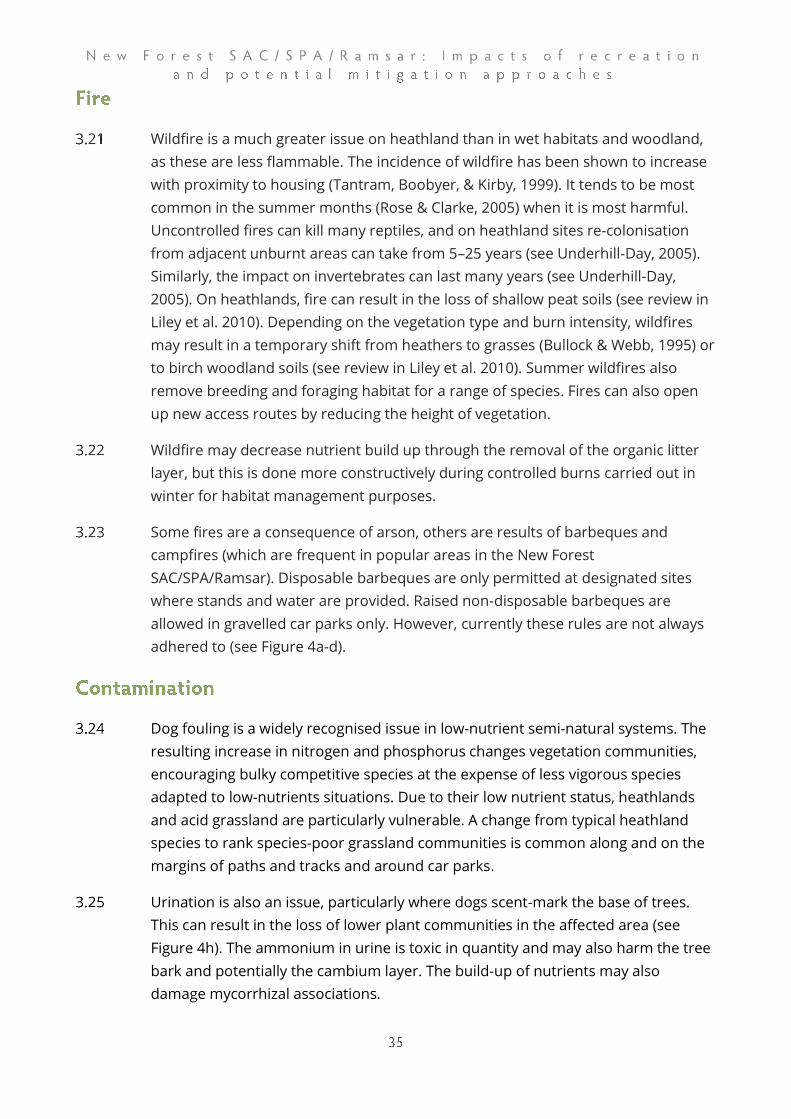
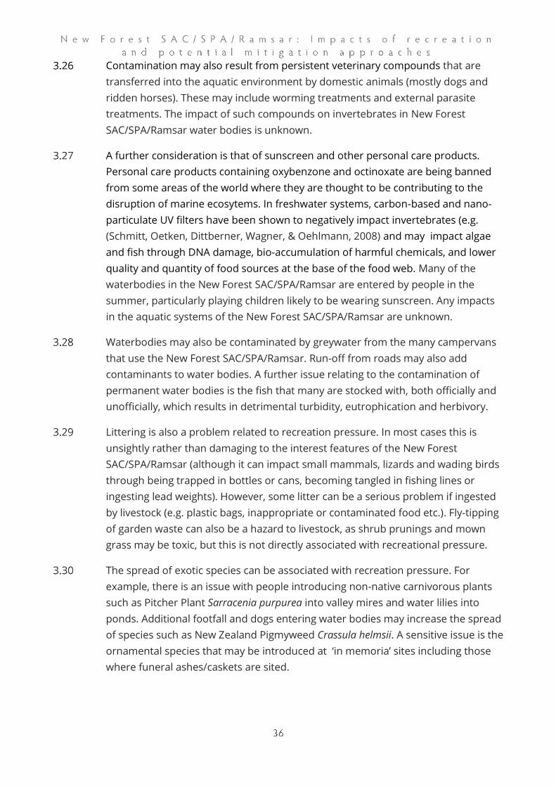
Some fires are a consequence of arson, others are results of barbeques and
campfires (which are frequent in popular areas in the New Forest
SAC/SPA/Ramsar). Disposable barbeques are only permitted at designated sites
where stands and water are provided. Raised non-disposable barbeques are
allowed in gravelled car parks only. However, currently these rules are not always
adhered to (see Figure 4a-d).
Dog fouling is a widely recognised issue in low-nutrient semi-natural systems. The
resulting increase in nitrogen and phosphorus changes vegetation communities,
encouraging bulky competitive species at the expense of less vigorous species
adapted to low-nutrients situations. Due to their low nutrient status, heathlands
and acid grassland are particularly vulnerable. A change from typical heathland
species to rank species-poor grassland communities is common along and on the
margins of paths and tracks and around car parks.
Urination is also an issue, particularly where dogs scent-mark the base of trees.
This can result in the loss of lower plant communities in the affected area (see
Figure 4h). The ammonium in urine is toxic in quantity and may also harm the tree
bark and potentially the cambium layer. The build-up of nutrients may also
damage mycorrhizal associations.
Contamination may also result from persistent veterinary compounds that are
transferred into the aquatic environment by domestic animals (mostly dogs and
ridden horses). These may include worming treatments and external parasite
treatments. The impact of such compounds on invertebrates in New Forest
SAC/SPA/Ramsar water bodies is unknown.
A further consideration is that of sunscreen and other personal care products.
Personal care products containing oxybenzone and octinoxate are being banned
from some areas of the world where they are thought to be contributing to the
disruption of marine ecosytems. In freshwater systems, carbon-based and nano-
particulate UV filters have been shown to negatively impact invertebrates (e.g.
(Schmitt, Oetken, Dittberner, Wagner, & Oehlmann, 2008) and may impact algae
and fish through DNA damage, bio-accumulation of harmful chemicals, and lower
quality and quantity of food sources at the base of the food web. Many of the
waterbodies in the New Forest SAC/SPA/Ramsar are entered by people in the
summer, particularly playing children likely to be wearing sunscreen. Any impacts
in the aquatic systems of the New Forest SAC/SPA/Ramsar are unknown.
Waterbodies may also be contaminated by greywater from the many campervans
that use the New Forest SAC/SPA/Ramsar. Run-off from roads may also add
contaminants to water bodies. A further issue relating to the contamination of
permanent water bodies is the fish that many are stocked with, both officially and
unofficially, which results in detrimental turbidity, eutrophication and herbivory.
Littering is also a problem related to recreation pressure. In most cases this is
unsightly rather than damaging to the interest features of the New Forest
SAC/SPA/Ramsar (although it can impact small mammals, lizards and wading birds
through being trapped in bottles or cans, becoming tangled in fishing lines or
ingesting lead weights). However, some litter can be a serious problem if ingested
by livestock (e.g. plastic bags, inappropriate or contaminated food etc.). Fly-tipping
of garden waste can also be a hazard to livestock, as shrub prunings and mown
grass may be toxic, but this is not directly associated with recreational pressure.
The spread of exotic species can be associated with recreation pressure. For
example, there is an issue with people introducing non-native carnivorous plants
such as Pitcher Plant Sarracenia purpurea into valley mires and water lilies into
ponds. Additional footfall and dogs entering water bodies may increase the spread
of species such as New Zealand Pigmyweed Crassula helmsii. A sensitive issue is the
ornamental species that may be introduced at ‘in memoria’ sites including those
where funeral ashes/caskets are sited.
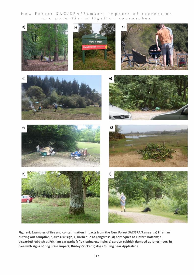
Figure 4: Examples of fire and contamination impacts from the New Forest SAC/SPA/Ramsar. a) Fireman
putting out campfire, b) fire risk sign, c) barbeque at Longcross; d) barbeques at Linford bottom; e)
discarded rubbish at Fritham car park; f) fly-tipping example; g) garden rubbish dumped at Janesmoor; h)
tree with signs of dog urine impact, Burley Cricket; i) dogs fouling near Appleslade.
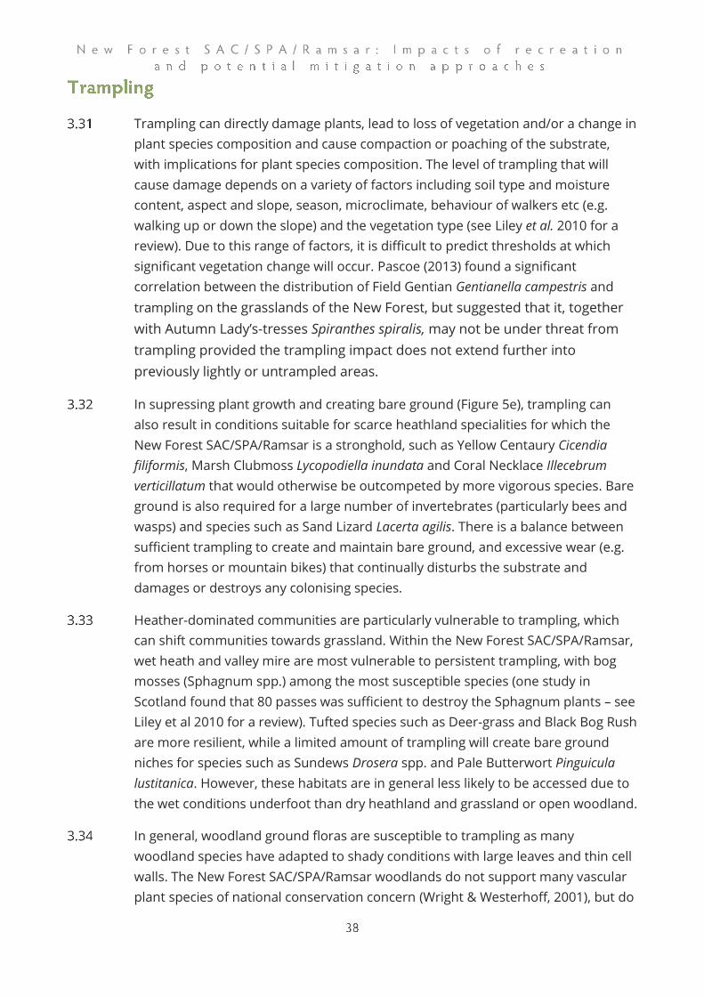
Trampling can directly damage plants, lead to loss of vegetation and/or a change in
plant species composition and cause compaction or poaching of the substrate,
with implications for plant species composition. The level of trampling that will
cause damage depends on a variety of factors including soil type and moisture
content, aspect and slope, season, microclimate, behaviour of walkers etc (e.g.
walking up or down the slope) and the vegetation type (see Liley et al. 2010 for a
review). Due to this range of factors, it is difficult to predict thresholds at which
significant vegetation change will occur. Pascoe (2013) found a significant
correlation between the distribution of Field Gentian Gentianella campestris and
trampling on the grasslands of the New Forest, but suggested that it, together
with Autumn Lady’s-tresses Spiranthes spiralis, may not be under threat from
trampling provided the trampling impact does not extend further into
previously lightly or untrampled areas.
In supressing plant growth and creating bare ground (Figure 5e), trampling can
also result in conditions suitable for scarce heathland specialities for which the
New Forest SAC/SPA/Ramsar is a stronghold, such as Yellow Centaury Cicendia
filiformis, Marsh Clubmoss Lycopodiella inundata and Coral Necklace Illecebrum
verticillatum that would otherwise be outcompeted by more vigorous species. Bare
ground is also required for a large number of invertebrates (particularly bees and
wasps) and species such as Sand Lizard Lacerta agilis. There is a balance between
sufficient trampling to create and maintain bare ground, and excessive wear (e.g.
from horses or mountain bikes) that continually disturbs the substrate and
damages or destroys any colonising species.
Heather-dominated communities are particularly vulnerable to trampling, which
can shift communities towards grassland. Within the New Forest SAC/SPA/Ramsar,
wet heath and valley mire are most vulnerable to persistent trampling, with bog
mosses (Sphagnum spp.) among the most susceptible species (one study in
Scotland found that 80 passes was sufficient to destroy the Sphagnum plants – see
Liley et al 2010 for a review). Tufted species such as Deer-grass and Black Bog Rush
are more resilient, while a limited amount of trampling will create bare ground
niches for species such as Sundews Drosera spp. and Pale Butterwort Pinguicula
lustitanica. However, these habitats are in general less likely to be accessed due to
the wet conditions underfoot than dry heathland and grassland or open woodland.
In general, woodland ground floras are susceptible to trampling as many
woodland species have adapted to shady conditions with large leaves and thin cell
walls. The New Forest SAC/SPA/Ramsar woodlands do not support many vascular
plant species of national conservation concern (Wright & Westerhoff, 2001), but do

have a rich flora of characteristic species. Excessive trampling by people, for
example at honeypots and along tracks (e.g. Figure 5d), can result in the localised
loss of ground flora and this has been well documented within the New Forest
(Cox, 1996b, 1996a, cited in ; Tubbs, 2001). The New Forest SAC/SPA/Ramsar is of
particular significance for its veteran trees, which can be negatively affected by
trampling. Trampling resulting in compaction around the roots will have a
detrimental effect on roots and associated soil fungi and can lead to tree death in
veteran trees, which may be preferentially approached. Climbing of trees may also
lead to damage.
Trampling can also be an issue in and around waterbodies, including permanent,
ephemeral and seasonal pools and running waters. Water bodies such as Hatchet
Pond, Janesmoor Pond, Cadnam’s Pool, Longcross Pond, Setley Pond, Ocknell
Pond, the Lymington River at Puttles Bridge, Ivy Wood, and Brockenhurst Splash
Bridge tend to be targeted as visitor destinations. Although a degree of trampling
in the margins of pools can create ideal conditions for species such as Pillwort
Pilularia globulifera, continued trampling (for example from dogs, horses and
people on the bankside or entering the water) can stir up the sediment, reducing
water quality and damaging aquatic plants. Excessive trampling will result in the
loss of fringing vegetation and the creation of worn, compacted edges (e.g. Figure
5c) – this has resulted in the complete loss of the transition from aquatic to
terrestrial vegetation at, for example, Cadnam’s Pool and reaches of the running
water sites listed above (C. Chatters pers. comm.).
Soil compaction and erosion issues are not only related to footfall. Bicycles can
damage soils and vegetation more than foot passage (Martin, Butler, & Klier, 2018)
and the impact of a horse plus rider is even greater in terms of ground pressure
(see Liddle, 1997 for review). Vehicles parking on road verges (e.g. Figure 5a) are a
particular issue, leading to localised damage alongside some roads (e.g. Figure 5b).
Repeated wear will result in bare edges and a loss of vegetation, likely to be of
particular concern for those verges with specialist flora such as small fleabane.
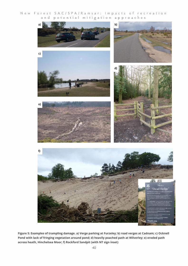
Figure 5: Examples of trampling damage. a) Verge parking at Furzeley; b) road verges at Cadnam; c) Ocknell
Pond with lack of fringing vegetation around pond; d) heavily poached path at Wilverley; e) eroded path
across heath, Hinchelsea Moor; f) Rockford Sandpit (with NT sign inset)
Livestock grazing is an integral part of the traditional management of the New
Forest and plays a key role in shaping habitats. There are several pathways
through which recreational pressure can impact on grazing livestock: worrying,
road accidents (although many may not be due to recreation), transfer of diseases,
feeding and petting livestock, damage to infrastructure and visitor perceptions and
expectations of the New Forest SAC/SPA/Ramsar as an area for recreation.
Increased visitor pressure in combination with increases in the numbers of
animals turned out on the Forest, is likely to exacerbate all of these.
Livestock worrying is generally considered to be a particular issue with sheep, but
young calves and foals are also vulnerable to dog attacks and fatal attacks are
reported7 each year. Dogs will approach and chase all livestock (e.g. Figure 6d) and
this can be dangerous, for example when animals run onto the road or towards
people. Where young animals are killed, injured or threatened, adult livestock may
be more likely to react badly to the presence of dogs, endangering both dogs and
people. It also has implications for the sustainability of livestock grazing, as, if
aggressive individuals cannot be identified, entire herds may have to be removed
from the Forest8. Attacks may be carried out by dogs escaping from properties in
or directly adjacent to the Forest in addition to those being exercised in the Forest.
Dogs are also an issue for the welfare of livestock through the transfer of
pathogens such as Neospora from dogs to cattle through dog faeces. Neospora
causes abortion in infected cattle.
While dogs are a particular issue, other activities can also alarm livestock. In
addition to increasing the potential for accidents, this can interfere with livestock
management.
The New Forest SAC/SPA/Ramsar is bisected by numerous roads, bringing cars and
livestock into proximity (e.g. Figure 6f). Road traffic accidents involving livestock are
also a regular occurrence in the New Forest – for example the Verderers reported
63 animals killed or put down due to the severity of their injuries in 2018, with a
further 26 animals injured. Parking on verges (e.g. Figure 6a) rather than in car
parks can limit drivers’ view of livestock, adding to the risk. Parking in gateways can
prevent access by livestock keepers. Depending on the management of parking,
this could increase with a rise in visitor numbers.
7 https://www.advertiserandtimes.co.uk/new-forest-dog-attack 8 https://www.advertiserandtimes.co.uk/new-forest-cows-slaughtered
Feeding and petting ponies is an issue in the New Forest SAC/SPA/Ramsar (e.g.
Figure 6b, c, e). Visitors enjoying the interaction with free-roaming ponies and
donkeys are often tempted to feed them. This can attract them to locations where
they are more vulnerable to traffic accidents or dog attacks, such as roadsides (see
Figure 6h) and car parks and influence the distribution of livestock within the New
Forest SAC/SPA/Ramsar. It can also result in incidents of aggression, as it increases
the number of interactions between equines and people, and ponies learn to
expect food and may respond aggressively if it is not forthcoming. It may also
result in the livestock being fed inappropriate foodstuffs.
Recreational pressure can also result in the displacement of livestock with, for
example, reports of incidents such as livestock being driven away from a pond to
allow model power boating.
There is a link between fire risk and grazing, as grazing can reduce fuel loads on
heathlands and therefore the risk of major wildfires (e.g. Cavan & McMorrow,
2009; Legg & Davies, 2009). Any future marked reductions in grazing (e.g. as a
result of the challenges of grazing alongside high levels of access) could have
knock on effects for fire risk across the Forest.
The New Forest SAC/SPA/Ramsar is a pastoral system – the nature conservation
features for which it is designated are dependent on the maintenance of
appropriate grazing. The various issues arising from interactions between
recreation pressure and livestock highlighted above potentially jeopardise the
future of commoning, the long-standing land-use system that has allowed the
continuation of extensive grazing within the New Forest. These impacts should be
considered in the context of a suite of issues currently impacting on commoning in
the New Forest (see Chatters & Kernohan 2013) .

Figure 6: Examples of grazing issues. a) verge parking near Furzeley to view ponies; b) pony being fed; c)
pony and ice cream van; d) dog approaching pony at Wilverley; e) pony approaching family barbeque at
Stoney Cross; f) car and pony, near Janesmoor; g) mountain biker approaching ponies near Stoney Cross; h)
abandoned carrots at Stoney Cross.
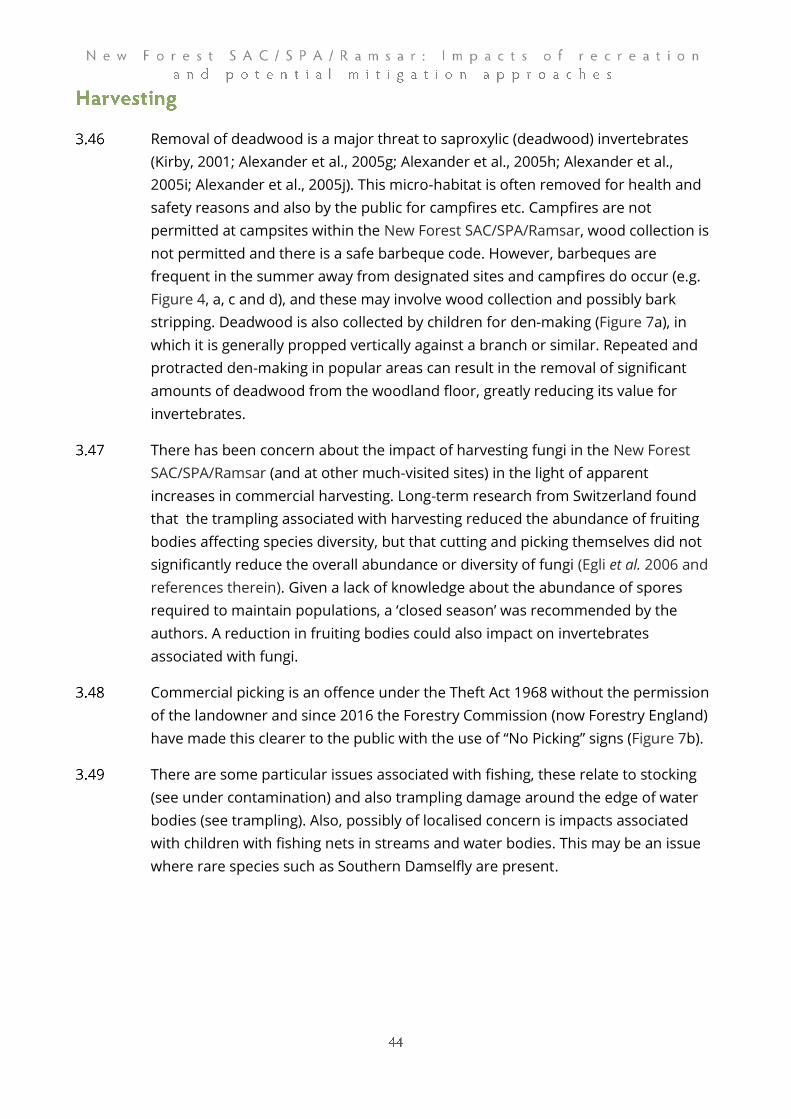
Removal of deadwood is a major threat to saproxylic (deadwood) invertebrates
(Kirby, 2001; Alexander et al., 2005g; Alexander et al., 2005h; Alexander et al.,
2005i; Alexander et al., 2005j). This micro-habitat is often removed for health and
safety reasons and also by the public for campfires etc. Campfires are not
permitted at campsites within the New Forest SAC/SPA/Ramsar, wood collection is
not permitted and there is a safe barbeque code. However, barbeques are
frequent in the summer away from designated sites and campfires do occur (e.g.
Figure 4, a, c and d), and these may involve wood collection and possibly bark
stripping. Deadwood is also collected by children for den-making (Figure 7a), in
which it is generally propped vertically against a branch or similar. Repeated and
protracted den-making in popular areas can result in the removal of significant
amounts of deadwood from the woodland floor, greatly reducing its value for
invertebrates.
There has been concern about the impact of harvesting fungi in the New Forest
SAC/SPA/Ramsar (and at other much-visited sites) in the light of apparent
increases in commercial harvesting. Long-term research from Switzerland found
that the trampling associated with harvesting reduced the abundance of fruiting
bodies affecting species diversity, but that cutting and picking themselves did not
significantly reduce the overall abundance or diversity of fungi (Egli et al. 2006 and
references therein). Given a lack of knowledge about the abundance of spores
required to maintain populations, a ‘closed season’ was recommended by the
authors. A reduction in fruiting bodies could also impact on invertebrates
associated with fungi.
Commercial picking is an offence under the Theft Act 1968 without the permission
of the landowner and since 2016 the Forestry Commission (now Forestry England)
have made this clearer to the public with the use of “No Picking” signs (Figure 7b).
There are some particular issues associated with fishing, these relate to stocking
(see under contamination) and also trampling damage around the edge of water
bodies (see trampling). Also, possibly of localised concern is impacts associated
with children with fishing nets in streams and water bodies. This may be an issue
where rare species such as Southern Damselfly are present.
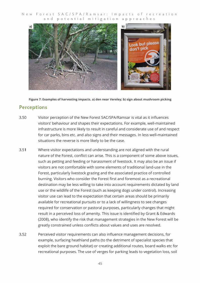
Figure 7: Examples of harvesting impacts. a) den near Vereley; b) sign about mushroom picking
Visitor perception of the New Forest SAC/SPA/Ramsar is vital as it influences
visitors’ behaviour and shapes their expectations. For example, well-maintained
infrastructure is more likely to result in careful and considerate use of and respect
for car parks, bins etc. and also signs and their messages. In less well-maintained
situations the reverse is more likely to be the case.
Where visitor expectations and understanding are not aligned with the rural
nature of the Forest, conflict can arise. This is a component of some above issues,
such as petting and feeding or harassment of livestock. It may also be an issue if
visitors are not comfortable with some elements of traditional land-use in the
Forest, particularly livestock grazing and the associated practice of controlled
burning. Visitors who consider the Forest first and foremost as a recreational
destination may be less willing to take into account requirements dictated by land
use or the wildlife of the Forest (such as keeping dogs under control). Increasing
visitor use can lead to the expectation that certain areas should be primarily
available for recreational pursuits or to a lack of willingness to see changes
required for conservation or pastoral purposes, particularly changes that might
result in a perceived loss of amenity. This issue is identified by Grant & Edwards
(2008), who identify the risk that management strategies in the New Forest will be
greatly constrained unless conflicts about values and uses are resolved.
Perceived visitor requirements can also influence management decisions, for
example, surfacing heathland paths (to the detriment of specialist species that
exploit the bare ground habitat) or creating additional routes, board walks etc for
recreational purposes. The use of verges for parking leads to vegetation loss, soil

compaction and, as such sites become more widely used, the creation of unofficial
car parks.
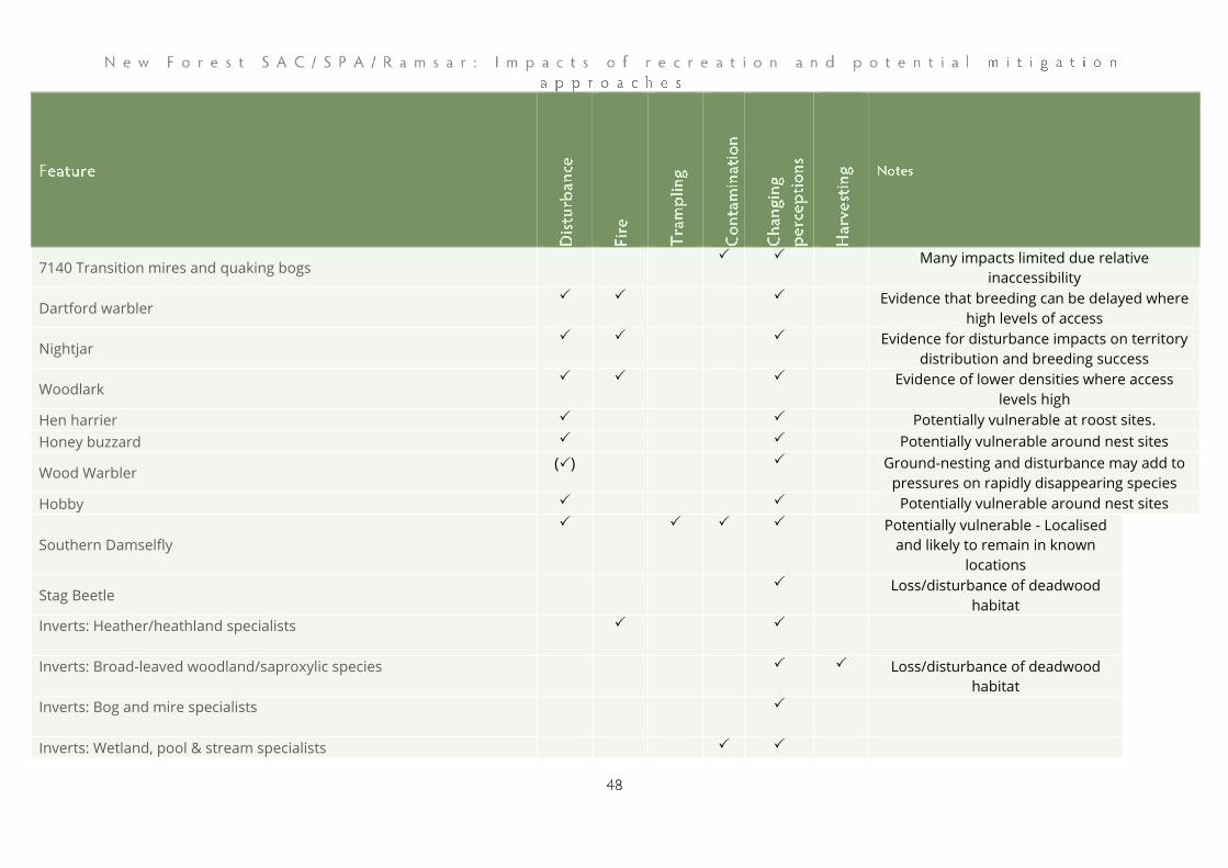
In Table 3 we provide an overview of the different impact pathways and the
interest features that are potentially vulnerable to that impact. Clearly the impacts
identified vary in severity, likelihood of occurrence (risk) and some affect particular
interest features while others are more general. While there are some marked
differences between the issues raised (den building is perhaps of less concern
compared to access fundamentally undermining the long-term future of the
traditional grazing), we have refrained from ranking or scoring them. This is
because some issues are likely to vary in their severity or risk in both time and
space, for example wildfires are only likely to start in particular weather conditions.
Some impacts will depend on the status of the species concerned. With Wood
Warbler being on the verge of extinction in the New Forest SAC/SPA/Ramsar, any
impact of disturbance on the species will be of concern. Furthermore, some of the
issues might, on their own, be considered of relatively little consequence when
broken down and discussed on an individual basis, as a single occurrence in one
part of the New Forest SAC/SPA/Ramsar. Yet it is the overall impact of all the issues
in synergy that needs to be considered, in the context of how access is spread
across the New Forest SAC/SPA/Ramsar, all year round.
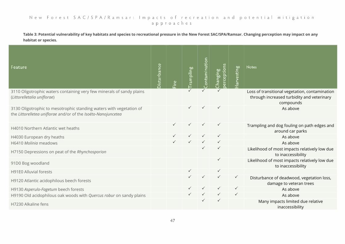
Table 3: Potential vulnerability of key habitats and species to recreational pressure in the New Forest SAC/SPA/Ramsar. Changing perception may impact on any
habitat or species.
3110 Oligotrophic waters containing very few minerals of sandy plains
(Littorelletalia uniflorae)
Loss of transitional vegetation, contamination
through increased turbidity and veterinary
compounds
3130 Oligotrophic to mesotrophic standing waters with vegetation of
the Littorelletea uniflorae and/or of the Isoëto-Nanojuncetea
As above
H4010 Northern Atlantic wet heaths Trampling and dog fouling on path edges and
around car parks
H4030 European dry heaths As above
H6410 Molinia meadows As above
H7150 Depressions on peat of the Rhynchosporion Likelihood of most impacts relatively low due
to inaccessibility
91D0 Bog woodland Likelihood of most impacts relatively low due
to inaccessibility
H91E0 Alluvial forests
H9120 Atlantic acidophilous beech forests Disturbance of deadwood, vegetation loss,
damage to veteran trees
H9130 Asperulo-Fagetum beech forests As above
H9190 Old acidophilous oak woods with Quercus robur on sandy plains As above
H7230 Alkaline fens Many impacts limited due relative
inaccessibility
7140 Transition mires and quaking bogs Many impacts limited due relative
inaccessibility
Dartford warbler Evidence that breeding can be delayed where
high levels of access
Nightjar Evidence for disturbance impacts on territory
distribution and breeding success
Woodlark Evidence of lower densities where access
levels high
Hen harrier Potentially vulnerable at roost sites.
Honey buzzard Potentially vulnerable around nest sites
Wood Warbler () Ground-nesting and disturbance may add to
pressures on rapidly disappearing species
Hobby Potentially vulnerable around nest sites
Southern Damselfly
Potentially vulnerable - Localised
and likely to remain in known
locations
Stag Beetle Loss/disturbance of deadwood
habitat
Inverts: Heather/heathland specialists
Inverts: Broad-leaved woodland/saproxylic species
Loss/disturbance of deadwood
habitat
Inverts: Bog and mire specialists
Inverts: Wetland, pool & stream specialists
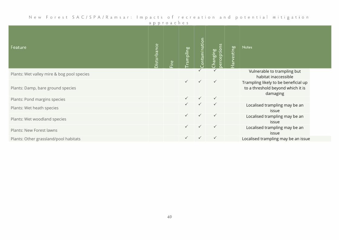
Plants: Wet valley mire & bog pool species Vulnerable to trampling but
habitat inaccessible
Plants: Damp, bare ground species
Trampling likely to be beneficial up
to a threshold beyond which it is
damaging
Plants: Pond margins species
Plants: Wet heath species Localised trampling may be an
issue
Plants: Wet woodland species Localised trampling may be an
issue
Plants: New Forest lawns Localised trampling may be an
issue
Plants: Other grassland/pool habitats Localised trampling may be an issue
Natural England’s site improvement plan from 2014 identifies a range of
pressures and threats to the condition of the New Forest SAC and SPA, and
in particular highlights:
• A significant long-term reduction in grazing pressure through loss
of commoning. This would lead to a dramatic change in the flora
and fauna of the New Forest and the impoverishment of the
special features for which is was designated.
• Impacts of recreation including disturbance to qualifying Natura
2000 species and compaction, abrasion and other modifications to
vegetation, soils and watercourses.
• Historic drainage of wetlands which leads to a loss of extent of
wetland habitats such as wet heath, mire, riverine and bog
woodland.
• Sylviculture plantations with recognisable remnants of SAC Annex
1 habitats such as heathland, mire, lawn, riverine and bog
woodland.
• Loss of traditional management practices which can lead to a loss
of extent and diversity of open habitats.
The SSSI condition assessment9 records that 54.4% of the SSSI is in
favourable condition, 41.9% is in unfavourable recovering condition, 2.1% is
unfavourable no change and 1.4% unfavourable declining.
It is important to note that the SSSI condition assessments are not
necessarily designed to pick up and record recreation impacts and are based
on a single visit by a Natural England officer. Issues such as bird disturbance
are unlikely to be picked up or systematically recorded. Many of the units are
very large, and if recreation issues are only in a part of the unit, they may not
necessarily be picked up. Nonetheless, recreation impacts (or possible
recreation impacts) are identified in the condition assessment for 18
different SSSI units, with comments covering topics such as trampling,
disturbance, vehicular damage, dead wood removal and littering. Some of
the units with issues are in favourable condition. We have included selected
extracts from the condition assessments in Appendix 1. Some units clearly
have very marked recreation issues, for example at Hollands Wood
Campsite:
9 Accessed from the Natural England website on 22/10/19

“The whole area is subject to very high visitor pressure and high levels of
trampling, removal of dead wood and disturbance of wildlife. There are
numerous indications of damaging impacts on the special interest features.”
At Balmer Lawn:
“In places there are indicators that recreational use is having a negative effect on
diversity especially close to the campsite from trampling and BBQ’s”
At Hatchet Pond:
“high levels of recreational disturbance have left much of the bank closest to the
car park bare and compacted”
Using estimates of possible housing levels over the period 2018-2036 and
the visitor survey results (see visitor survey summary report) we estimate
that there will be an increase in the level of access of around 11%, solely
from new housing within a 25km radius. There will be further increases
above this as a result of tourism (staying visitors from a wide geographic
spread) and day visits from people living beyond 25km. Previous sections
highlight the current condition and status of the interest features and
potential risks from recreation. While there are clearly a range of factors
influencing the status and distribution of relevant interest features, many
species are not doing well in the New Forest. More visitors will increase the
pressure in general, exacerbate the current issues and there is the potential
for further impacts. In this section of the report we consider the options for
mitigation.
Each planning authority should have a well-informed and articulated
mitigation scheme, commensurate with the distribution of proposed
development in relation to the New Forest SAC/SPA/Ramsar. Ideally these
schemes would aim to achieve similar outcomes, through a single joined-up
approach. In other parts of the UK10, strategic approaches to mitigation have
been established where multiple local authorities fund a series of consistent,
agreed and implementable measures carefully designed to resolve the in-
combination impacts associated with local development. In this section we
consider the kinds of measures which might be applicable to the New Forest
SAC/SPA/Ramsar and the benefits of a proportionate and co-ordinated
strategic, approach.
Legislative context
Relevant European and domestic legislation is cited in the introduction and
these provide strict protection to our most important nature conservation
sites, such as the New Forest. The application of the European legislation
needs to be made with regard for the way in which the protective
requirements should be secured by public bodies. The legislation requires
10 For example the Dorset Heaths, the Thames Basin Heaths, South-east Devon, Cannock Chase
and the Solent
public bodies to be proactive, rather than reactive. The overarching objective
is to maintain sites and their interest features in an ecologically robust and
viable state, able to sustain and thrive into the long term, with adequate
resilience against natural influences. This requires public bodies to put
measures in place to prevent deterioration of European sites, not to wait
until there is harm occurring that needs to be rectified. Where European
sites are not achieving their potential, the focus of attention by public bodies
should be on restoration.
Public bodies are referred to as ‘competent authorities’ within the legislation.
The duties set out within the Habitats Regulations in relation to the
consideration of plans and projects are applicable in situations where the
competent authority is undertaking or implementing a plan or project, or
authorising others to do so. The assessment process is called a Habitats
Regulations Assessment (‘HRA’) and it is the HRAs of local plans relating to
the areas within and adjacent to the New Forest that have identified the
issue of increased recreation pressure on European sites as a result of
housing development and the associated increased population. The
European legislation is founded on the ‘precautionary principle’, i.e. it is
necessary to demonstrate that impacts will not occur, rather than have proof
that they will.
Wider context
It is relevant to note that there is an existing strategic approach to recreation
issues from housing around the Solent, which includes the shoreline within
the New Forest National Park. In addition, looking west, there is a strategic
mitigation approach for the Dorset Heaths. As such there are established
approaches to mitigation and there is likely to be some overlap, as people
may well visit both the heath/woodland areas and the coast.
Within the New Forest SAC/SPA/Ramsar site access to many areas is a legal
right, with open access to many areas. There are in excess of 30,000ha of
unenclosed land where people can walk freely (NFNPA, 2010) and this
includes the heaths, woodlands and commons managed by the Forestry
England, National Trust, Hampshire County Council and others.
The second statutory purpose of the English National Parks (including the
New Forest) is to promote opportunities for the understanding and
enjoyment of the special qualities of the area by the public. The
Government's recent Landscapes Review (Glover, 2019) has proposed a
further strengthening of this so that people have better opportunities to
experience our nationally protected landscapes. It has however long been
recognised that there can be potential conflicts between balancing
recreation and nature conservation in National Parks. The Sandford
Principle11 recognises that if there is a conflict between protecting the
environment and people enjoying the environment, that can't be resolved by
management of a National Park, then protecting the environment takes
precedent.
Existing recreation management measures and HRA findings
Recreation has been managed in the New Forest for many years (see NFNPA,
2010 for background). It was in 1972, following the conservation plan (New
Forest Joint Steering Committee, 1971) that the current network of car parks
was created and cars were stopped from driving across the lawns and open
land. In the early 1990s the 40mph speed limit on unfenced roads was
introduced within the Perambulation of the Forest. The Recreation
Management Strategy (RMS) set out a strategic direction for the
management of outdoor recreation in the New Forest National Park from
2010 – 2030 (NFNPA, 2010). More recently it has been recognised that the
strategy needs updating. Forestry England, Natural England, Hampshire
County Council, New Forest District Council, Test Valley Borough Council, the
Verderers and the New Forest National Park Authority have been working
together on that update, which included a Future Forest consultation in 2017
and further public consultation in 2018.
The update12 has identified 22 strategic actions which fall under seven
broader objectives:
• Convey the things that make the New Forest National Park special
to both visitors and local people in more consistent and effective
ways, so that they enjoy it, come to value it, want to care for it and
do not inadvertently damage it;
• Address significant and/or widespread negative impacts caused by
recreation in the most appropriate, proportionate and effective
ways;
• Reduce the barriers that limit participation in beneficial outdoor
recreation among those who need it most;
11 Named after Lord Sandford, who chaired the 1974 National Parks Policy Review Committee. 12 May 2019 update, https://www.newforestnpa.gov.uk/app/uploads/2019/07/Recreation-
Management-Strategy-Strategic-Actions.pdf
• Protect and enhance the New Forest’s working and natural
landscape, and improve the recreational experience, by influencing
where recreation takes place;
• Increase the level of funding available for recreation management
so that it is sufficient to address both existing and upcoming
needs;
• Collate data and evidence to help inform the ongoing management
of recreation;
• Regularly review progress against agreed recreation management
actions and adapt forward plans to protect the special qualities of
the National Park and enable people to enjoy and benefit from
them.
The Recreation Management Strategy therefore plays a wider role than that
required to mitigate the impacts of recreation on the SPA/SAC arising from
new development (the focus of this study). The Recreation Management
Strategy is much broader in its aims and relates to people visiting from
anywhere, including people on holiday.
HRA work at plan level has identified recreation issues and the New Forest
SAC/SPA/Ramsar site for a number of local authorities surrounding the New
Forest SAC/SPA/Ramsar. In order to rule out adverse effects on integrity for
existing plan documents, a range of mitigation measures and approaches
have been established in policy. For example, the New Forest District
Council, the New Forest National Park Authority and Test Valley Borough
Council each have an established approach for mitigation delivery that
includes measures such as rangers, provision of alternative greenspace and
improvements to public rights of way.
Benefits of a strategic approach
The measures developed for the Recreation Management Strategy are likely
to help mitigate impacts on the designated sites, but there remains a key
role for a mitigation strategy focused on the impacts of planned new
development. Where impacts relate to the cumulative, in-combination
effects of development over a wide area, effective mitigation is very difficult
to deliver on a dwelling by dwelling basis. A broad ‘package’ of mitigation
measures is likely to prove the most effective, potentially involved visitor
engagement, access management within the New Forest SAC/SPA/Ramsar
site and provision of new green infrastructure. These can only be funded and
established through some kind of partnership approach. A strategic
approach is built on the principle that by putting together a suite of
interrelated measures, that work collectively to target key mitigation areas
such as visitor education, dedicated staff, visitor infrastructure
improvements or providing alternative locations for some aspects of
recreation, a robust multi-layered strategy can give certainty in effectiveness.
By working together, local authorities can ensure consistency and allow
measures to spill across their respective boundaries.
There are benefits for developers as mitigation measures that would
otherwise be undeliverable can be secured and established up front, by the
local authority. The costs are transparent, known in advance and the
developer avoids the risk of development being refused due to impacts to
the New Forest SAC/SPA/Ramsar from recreation. With a consistent
approach there is less chance of development in one location being subject
to different costs and mitigation requirements to another location just over a
local authority boundary.
There is also the potential for additional benefits. Proportionate and co-
ordinated strategic mitigation allows ambitious programmes of green
infrastructure to be carefully planned, bringing benefits to local
communities. There can also be opportunities to provide biodiversity net
gain through the creation of new green spaces (even if managed primarily
for access).
Working closely with the steering group and drawing on the results of the
visitor survey work undertaken in parallel with this report, we have identified
a number of potential mitigation options. These fit with the strategic actions
identified through the work to update the New Forest National Park
Recreation Management Strategy 2010-2030 and are also intended to guide
relevant authorities’ approach to mitigating future housing growth in
compliance with Habitats Regulations.
These mitigation options are set out below under different headings that
include alternative greenspace, access management within the designated
sites and education and awareness raising. Under each heading we list the
options as a series of bullet points and then summarise key points that arose
from a workshop, held in July 2019, with a range of stakeholders including
Verderers, commoners, local authority staff, representatives from the
National Park, Natural England and conservation NGOs. As relevant, we then

discuss the options in more depth, drawing on the visitor survey results to
consider how they might inform some of the measures.
All options are then summarised together at the end of the report.
These approaches are off-site, away from the New Forest SAC/SPA/Ramsar
site and involve measures to accommodate recreation in more robust areas,
including (in no particular order):
• Improvements to existing greenspaces to attract and
accommodate increased use (more people or/and increased dwell
time)
• Provision of new greenspaces within or adjoining residential
development sites to provide appropriate alternative recreational
facilities ‘on the doorstep’ of residents of those new housing
developments.
• New ‘destination’ greenspaces (e.g. country parks) designed to
attract people from surrounding towns and villages
• Designated locations for off-lead dog walking/training and ‘bike
parks’ (could be a commercial venture on private land)
• Improved rights of way (public footpaths and bridleways) to
increase usage (through higher levels of maintenance, enhanced
signage and/or interpretation)
At the workshop held in July 2019, key points relating to alternative
greenspace sites included:
• Overall support for all options, ranging from large country parks to
the minor improvements to local footpaths, as part of a ‘toolkit’ for
mitigation;
• Any greenspaces need to have attractive features, targeted at the
relevant site user groups, such as dog walkers, and be of a high
quality.
• Important to provide a choice of greenspace for the needs of
‘locals’ vs. ‘tourists’ which seek different experiences. Locals need
closer, convenient sites for more regular use.
• The provision of a new large country park was the one identified
potential measure currently missing from the mitigation packages
already being implemented by local planning authorities. The
pooling of developer contributions from development across the
identified catchment area would assist in funding such provision.
• There are some clear examples of large country parks which work
well e.g. Upton, Moors Valley (but may already be capacity issues at
these). Cost and space are the main issue for these parks but
capacity could be increased by working across local
authorities/partners.
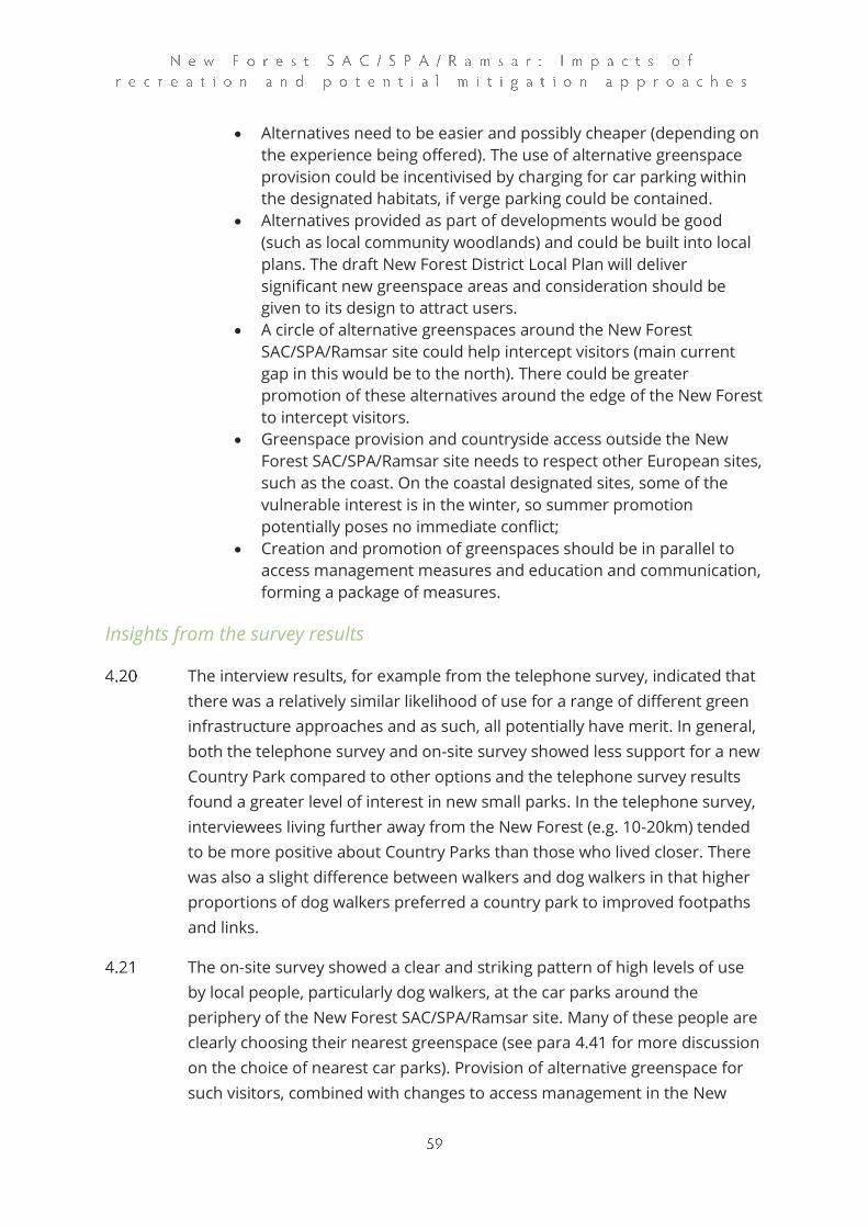
• Alternatives need to be easier and possibly cheaper (depending on
the experience being offered). The use of alternative greenspace
provision could be incentivised by charging for car parking within
the designated habitats, if verge parking could be contained.
• Alternatives provided as part of developments would be good
(such as local community woodlands) and could be built into local
plans. The draft New Forest District Local Plan will deliver
significant new greenspace areas and consideration should be
given to its design to attract users.
• A circle of alternative greenspaces around the New Forest
SAC/SPA/Ramsar site could help intercept visitors (main current
gap in this would be to the north). There could be greater
promotion of these alternatives around the edge of the New Forest
to intercept visitors.
• Greenspace provision and countryside access outside the New
Forest SAC/SPA/Ramsar site needs to respect other European sites,
such as the coast. On the coastal designated sites, some of the
vulnerable interest is in the winter, so summer promotion
potentially poses no immediate conflict;
• Creation and promotion of greenspaces should be in parallel to
access management measures and education and communication,
forming a package of measures.
Insights from the survey results
The interview results, for example from the telephone survey, indicated that
there was a relatively similar likelihood of use for a range of different green
infrastructure approaches and as such, all potentially have merit. In general,
both the telephone survey and on-site survey showed less support for a new
Country Park compared to other options and the telephone survey results
found a greater level of interest in new small parks. In the telephone survey,
interviewees living further away from the New Forest (e.g. 10-20km) tended
to be more positive about Country Parks than those who lived closer. There
was also a slight difference between walkers and dog walkers in that higher
proportions of dog walkers preferred a country park to improved footpaths
and links.
The on-site survey showed a clear and striking pattern of high levels of use
by local people, particularly dog walkers, at the car parks around the
periphery of the New Forest SAC/SPA/Ramsar site. Many of these people are
clearly choosing their nearest greenspace (see para 4.41 for more discussion
on the choice of nearest car parks). Provision of alternative greenspace for
such visitors, combined with changes to access management in the New
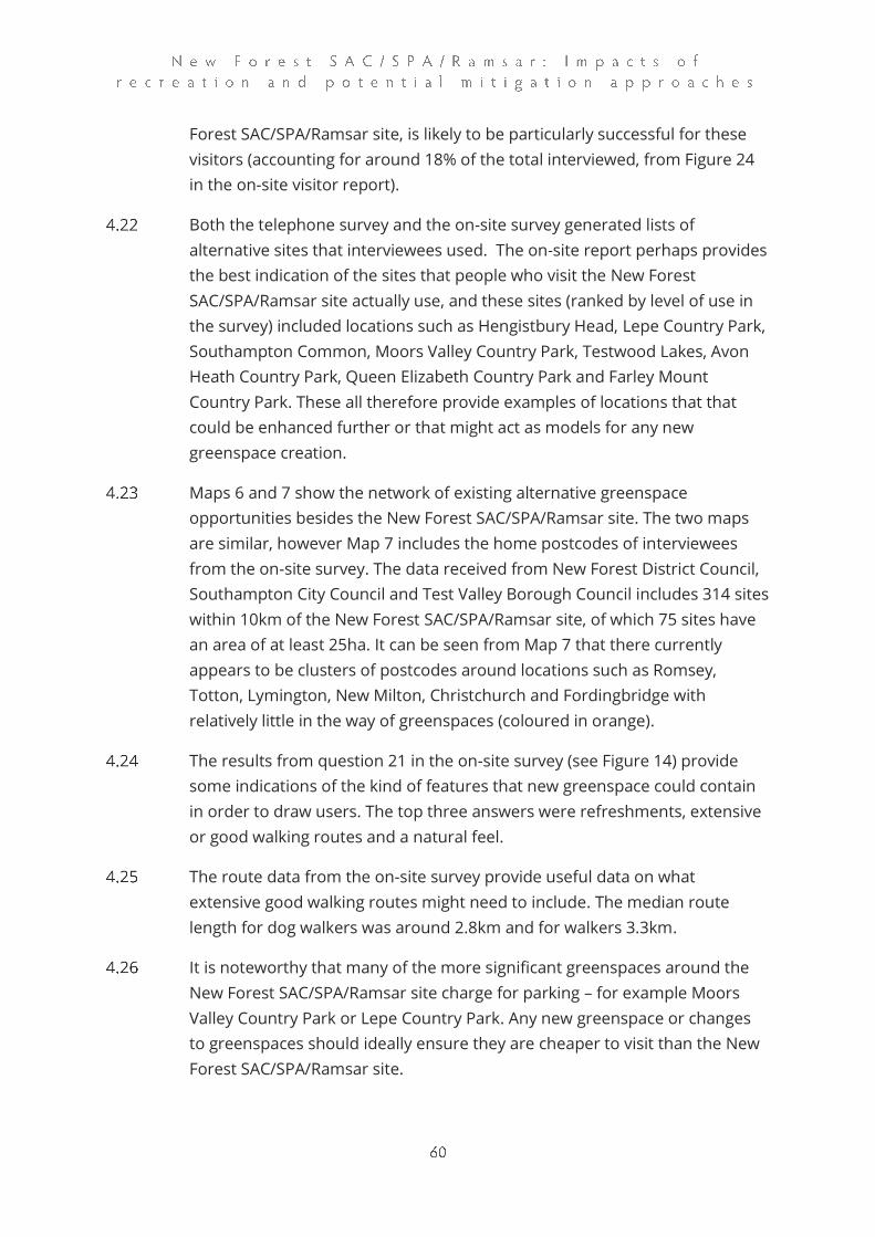
Forest SAC/SPA/Ramsar site, is likely to be particularly successful for these
visitors (accounting for around 18% of the total interviewed, from Figure 24
in the on-site visitor report).
Both the telephone survey and the on-site survey generated lists of
alternative sites that interviewees used. The on-site report perhaps provides
the best indication of the sites that people who visit the New Forest
SAC/SPA/Ramsar site actually use, and these sites (ranked by level of use in
the survey) included locations such as Hengistbury Head, Lepe Country Park,
Southampton Common, Moors Valley Country Park, Testwood Lakes, Avon
Heath Country Park, Queen Elizabeth Country Park and Farley Mount
Country Park. These all therefore provide examples of locations that that
could be enhanced further or that might act as models for any new
greenspace creation.
Maps 6 and 7 show the network of existing alternative greenspace
opportunities besides the New Forest SAC/SPA/Ramsar site. The two maps
are similar, however Map 7 includes the home postcodes of interviewees
from the on-site survey. The data received from New Forest District Council,
Southampton City Council and Test Valley Borough Council includes 314 sites
within 10km of the New Forest SAC/SPA/Ramsar site, of which 75 sites have
an area of at least 25ha. It can be seen from Map 7 that there currently
appears to be clusters of postcodes around locations such as Romsey,
Totton, Lymington, New Milton, Christchurch and Fordingbridge with
relatively little in the way of greenspaces (coloured in orange).
The results from question 21 in the on-site survey (see Figure 14) provide
some indications of the kind of features that new greenspace could contain
in order to draw users. The top three answers were refreshments, extensive
or good walking routes and a natural feel.
The route data from the on-site survey provide useful data on what
extensive good walking routes might need to include. The median route
length for dog walkers was around 2.8km and for walkers 3.3km.
It is noteworthy that many of the more significant greenspaces around the
New Forest SAC/SPA/Ramsar site charge for parking – for example Moors
Valley Country Park or Lepe Country Park. Any new greenspace or changes
to greenspaces should ideally ensure they are cheaper to visit than the New
Forest SAC/SPA/Ramsar site.
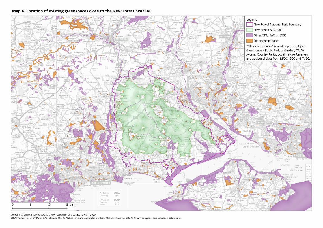
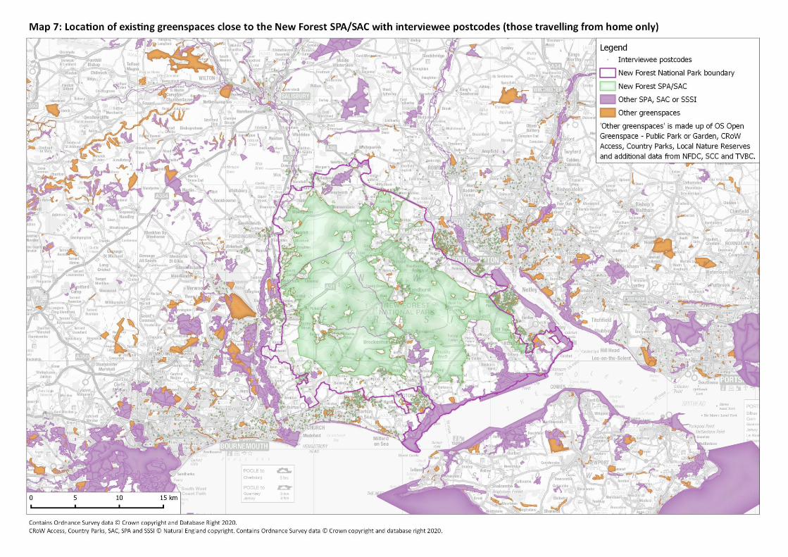
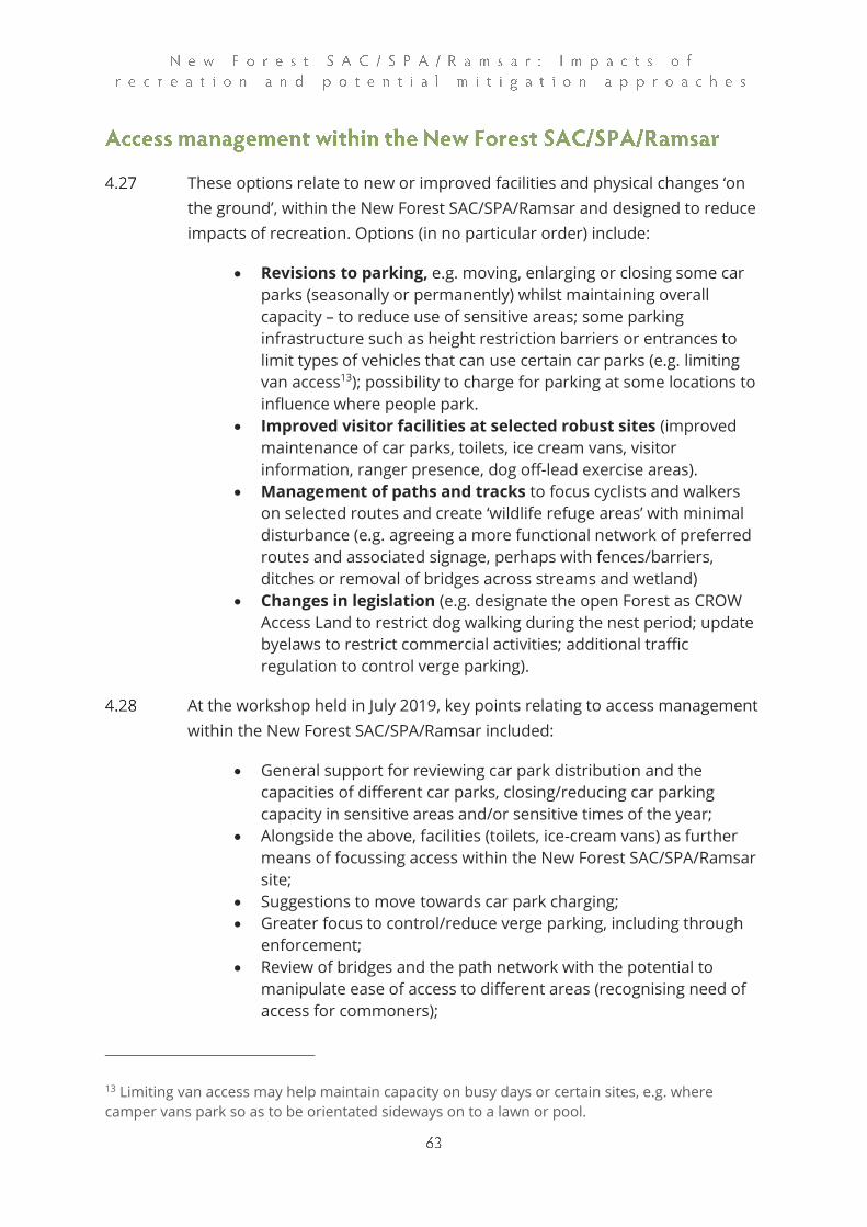
These options relate to new or improved facilities and physical changes ‘on
the ground’, within the New Forest SAC/SPA/Ramsar and designed to reduce
impacts of recreation. Options (in no particular order) include:
• Revisions to parking, e.g. moving, enlarging or closing some car
parks (seasonally or permanently) whilst maintaining overall
capacity – to reduce use of sensitive areas; some parking
infrastructure such as height restriction barriers or entrances to
limit types of vehicles that can use certain car parks (e.g. limiting
van access13); possibility to charge for parking at some locations to
influence where people park.
• Improved visitor facilities at selected robust sites (improved
maintenance of car parks, toilets, ice cream vans, visitor
information, ranger presence, dog off-lead exercise areas).
• Management of paths and tracks to focus cyclists and walkers
on selected routes and create ‘wildlife refuge areas’ with minimal
disturbance (e.g. agreeing a more functional network of preferred
routes and associated signage, perhaps with fences/barriers,
ditches or removal of bridges across streams and wetland)
• Changes in legislation (e.g. designate the open Forest as CROW
Access Land to restrict dog walking during the nest period; update
byelaws to restrict commercial activities; additional traffic
regulation to control verge parking).
At the workshop held in July 2019, key points relating to access management
within the New Forest SAC/SPA/Ramsar included:
• General support for reviewing car park distribution and the
capacities of different car parks, closing/reducing car parking
capacity in sensitive areas and/or sensitive times of the year;
• Alongside the above, facilities (toilets, ice-cream vans) as further
means of focussing access within the New Forest SAC/SPA/Ramsar
site;
• Suggestions to move towards car park charging;
• Greater focus to control/reduce verge parking, including through
enforcement;
• Review of bridges and the path network with the potential to
manipulate ease of access to different areas (recognising need of
access for commoners);
13 Limiting van access may help maintain capacity on busy days or certain sites, e.g. where
camper vans park so as to be orientated sideways on to a lawn or pool.

• Dead-hedging and use of cut material, brash etc. provides a further
means to subtly divert access;
• Face-face (ranger) presence another means to direct access and
promote good behaviour;
• There was a suggestion that the inclosures could be promoted and
access more concentrated in these areas, particularly dog walking;
• Support for a mechanism to ensure dogs on leads could be
enforced, potentially through designating the open Forest as
CROW14 Access Land to restrict dog walking during the nest period.
Insights from the survey results
The visitor survey results provide some information which will help to target
and tailor on-site management.
Around 8% of interviewees in the on-site survey chose to visit the interview
location that day because of the choice of routes available. Around 2% of
interviewees chose locations based on the quality of the paths and avoiding
mud.
The route data, as mapped from the on-site survey, provide information on
where people went during their visit. There is scope to interrogate these data
at individual access points to review options for managing the path network
at specific locations.
Cyclists are a group where use of designated routes is of interest. The cycle
routes are shown in Map 6 in the on-site report: this shows all those who
were cycling and this indicates cycle use much more focussed along
particular routes than the maps for the other activities. The same route data
for cyclists are also shown in Map 8 (below), here using red lines, with the
intensity of the red colour reflecting levels of use. These are shown on top of
the road network (white) and National Cycle Routes/approved cycle routes15
in yellow. This allows us to visualise where cyclists have been recorded away
from dedicated routes (i.e. where red lines are over the green background)
and therefore where there could be opportunities for measures to be put in
place. These locations include just north of Denny Wood, Beaulieu Heath,
Wilverley Plain and the northern corner, south of the B3078 and north of
Abbotswell/Fritham.
14 The Countryside and Rights of Way Act 2000 15 Note this does not include bridleways.

95% of interviewees who were off road cyclists/ mountain bikers used the
National Cycle Routes or other approved cycle routes at some point (for on
road cyclists this was 86%). Other key groups who used these routes were:
runners (70%); horse riders (58%); Duke of Edinburgh groups (57%) and
walkers (57%). The average length of route for those who used the approved
cycle routes was 9,171 m for off road cyclists/ mountain bikers and 6,568 m
for road cyclists. Using the total route length across all interviewees, roughly
63% of the off-road cyclists’/mountain bikers’ route length was on the cycle
routes, while this was no more than 39% for any other categories, including
35% for on road cycling.
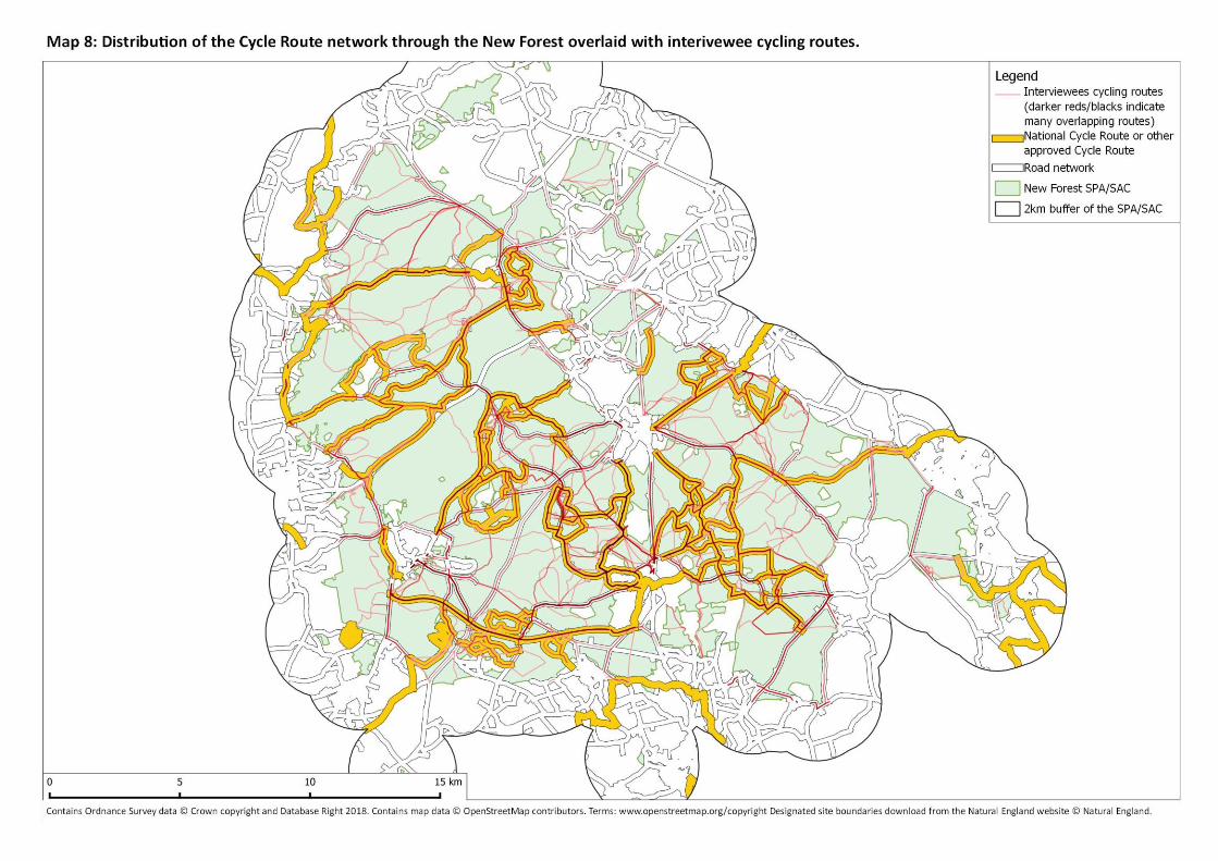

Mitigation options relating to car parks could include changing the
distribution of car parks, modifying capacity at different locations, additional
infrastructure (height restriction bars, measures to influence how people
orientate the vehicles), charging etc. Such measures need to be carefully
reviewed, selected and supported by evidence, but there is clearly potential
to change the distribution and volume of visitor pressure at different
locations through changes to parking. Reducing the overall volume of cars
would be beneficial for a wide range of reasons.
Many of the greenspaces around the SAC/SPA/Ramsar site charge for
parking. Furthermore, there is a charge to park in the town and village centre
car parks within the New Forest. As such, the SAC/SPA/Ramsar site is
relatively unique in offering free parking to visitors. The lack of parking
charges may help instil in visitors a sense that the open Forest is a free for
all, and that there are no restrictions.
As part of the preparatory work to undertake the vehicle counts, we collated
GIS data on the number of parking locations providing access to the New
Forest SAC/SPA/Ramsar. This included all formal parking locations and lay-
bys, gateways and other informal parking areas that were clearly used for
parking. While this doesn’t include the town centre car parks, the lay-bys on
the A31, camp-sites and other parking linked to holiday accommodation and
open verges where people stop at random, it represents the majority of the
parking available for day-visitors.
We estimate the overall parking capacity to be 270 locations and 4,813
spaces. 147 of the locations (54%) are formal car parks and these account for
around 4,442 spaces (92%). Looking at the count data from the vehicle
surveys, the Easter Sunday count provided an exceptionally high count on a
day when warm sunshine coincided with the bank holiday weekend. Such
spikes in visitor numbers, at a time when many species of bird are settling on
territory or just starting to incubate may have particular implications for bird
disturbance.
On that busy Easter Sunday we counted 2,908 parked vehicles, this was
around 60% of the available parking capacity. Notably, that Easter peak was
around 10x that of the previous count and indicates the very marked spikes
in access that can occur. Even with such peaks, it is interesting to note that
there is apparently some further capacity still available and therefore
potentially more parking spaces than are necessary. However, it is important
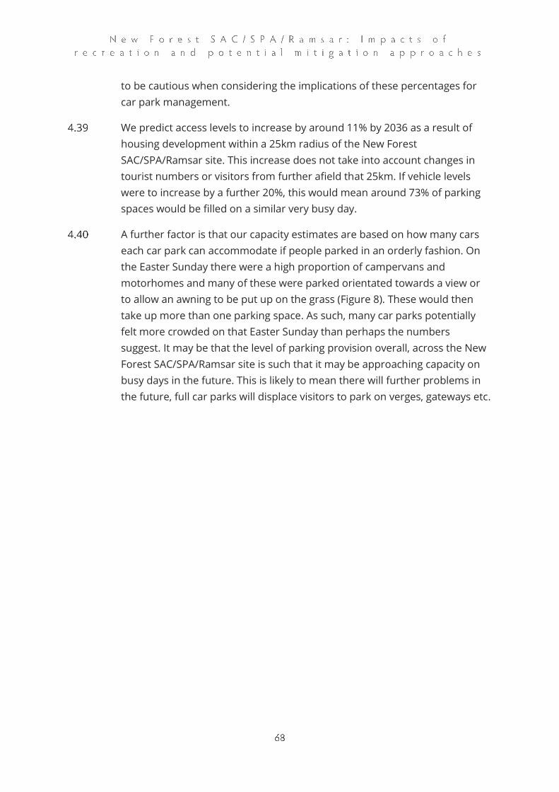
to be cautious when considering the implications of these percentages for
car park management.
We predict access levels to increase by around 11% by 2036 as a result of
housing development within a 25km radius of the New Forest
SAC/SPA/Ramsar site. This increase does not take into account changes in
tourist numbers or visitors from further afield that 25km. If vehicle levels
were to increase by a further 20%, this would mean around 73% of parking
spaces would be filled on a similar very busy day.
A further factor is that our capacity estimates are based on how many cars
each car park can accommodate if people parked in an orderly fashion. On
the Easter Sunday there were a high proportion of campervans and
motorhomes and many of these were parked orientated towards a view or
to allow an awning to be put up on the grass (Figure 8). These would then
take up more than one parking space. As such, many car parks potentially
felt more crowded on that Easter Sunday than perhaps the numbers
suggest. It may be that the level of parking provision overall, across the New
Forest SAC/SPA/Ramsar site is such that it may be approaching capacity on
busy days in the future. This is likely to mean there will further problems in
the future, full car parks will displace visitors to park on verges, gateways etc.
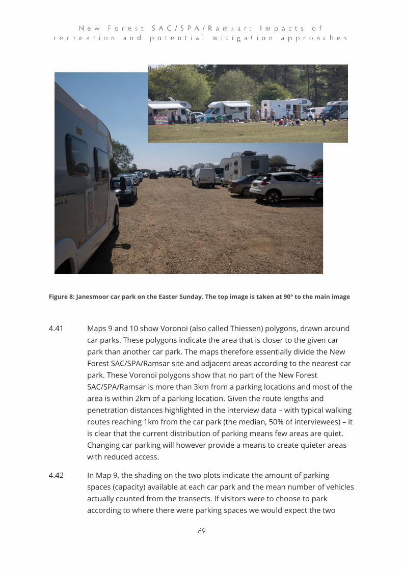
Figure 8: Janesmoor car park on the Easter Sunday. The top image is taken at 90° to the main image
Maps 9 and 10 show Voronoi (also called Thiessen) polygons, drawn around
car parks. These polygons indicate the area that is closer to the given car
park than another car park. The maps therefore essentially divide the New
Forest SAC/SPA/Ramsar site and adjacent areas according to the nearest car
park. These Voronoi polygons show that no part of the New Forest
SAC/SPA/Ramsar is more than 3km from a parking locations and most of the
area is within 2km of a parking location. Given the route lengths and
penetration distances highlighted in the interview data – with typical walking
routes reaching 1km from the car park (the median, 50% of interviewees) – it
is clear that the current distribution of parking means few areas are quiet.
Changing car parking will however provide a means to create quieter areas
with reduced access.
In Map 9, the shading on the two plots indicate the amount of parking
spaces (capacity) available at each car park and the mean number of vehicles
actually counted from the transects. If visitors were to choose to park
according to where there were parking spaces we would expect the two
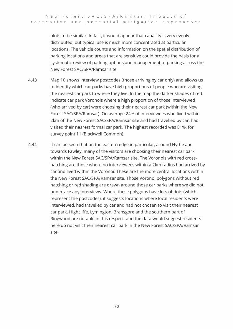
plots to be similar. In fact, it would appear that capacity is very evenly
distributed, but typical use is much more concentrated at particular
locations. The vehicle counts and information on the spatial distribution of
parking locations and areas that are sensitive could provide the basis for a
systematic review of parking options and management of parking across the
New Forest SAC/SPA/Ramsar site.
Map 10 shows interview postcodes (those arriving by car only) and allows us
to identify which car parks have high proportions of people who are visiting
the nearest car park to where they live. In the map the darker shades of red
indicate car park Voronois where a high proportion of those interviewed
(who arrived by car) were choosing their nearest car park (within the New
Forest SAC/SPA/Ramsar). On average 24% of interviewees who lived within
2km of the New Forest SAC/SPA/Ramsar site and had travelled by car, had
visited their nearest formal car park. The highest recorded was 81%, for
survey point 11 (Blackwell Common).
It can be seen that on the eastern edge in particular, around Hythe and
towards Fawley, many of the visitors are choosing their nearest car park
within the New Forest SAC/SPA/Ramsar site. The Voronois with red cross-
hatching are those where no interviewees within a 2km radius had arrived by
car and lived within the Voronoi. These are the more central locations within
the New Forest SAC/SPA/Ramsar site. Those Voronoi polygons without red
hatching or red shading are drawn around those car parks where we did not
undertake any interviews. Where these polygons have lots of dots (which
represent the postcodes), it suggests locations where local residents were
interviewed, had travelled by car and had not chosen to visit their nearest
car park. Highcliffe, Lymington, Bransgore and the southern part of
Ringwood are notable in this respect, and the data would suggest residents
here do not visit their nearest car park in the New Forest SAC/SPA/Ramsar
site.
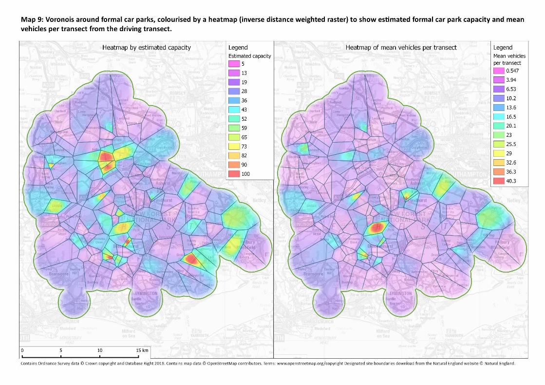
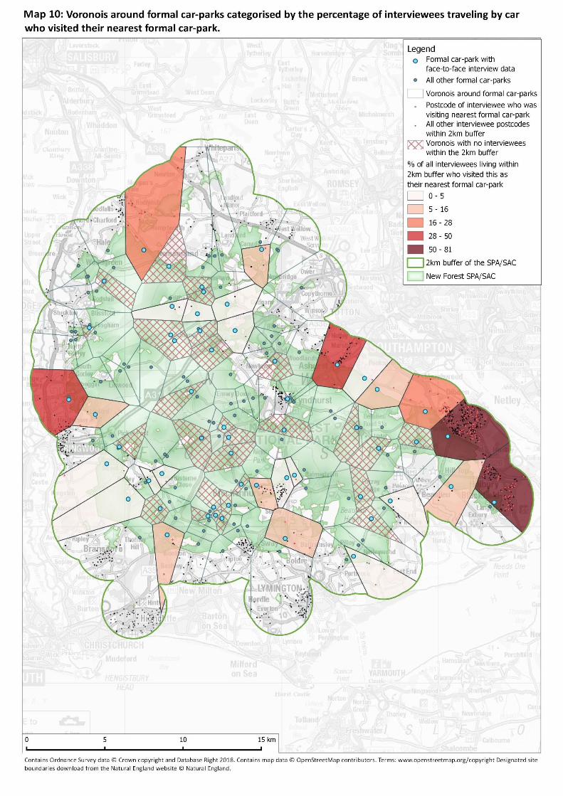

These types of measures encourage responsible recreation, e.g. through
websites, social media, leaflets and other publications, posters and signage,
exhibitions, film, art, face-to-face communication and enforcement. Options
include:
• Better information and interpretation about the things that
make the designated sites special (especially wildlife and the vital
role of commoning) and their vulnerability to harm from
recreation. This could include the promotion of agreed key,
consistent messages by people and organisations that actively
promote the New Forest as a destination.
• Guided walks and themed events and activities run by local
knowledgeable people to give local people and visitors authentic
experiences and first-hand contact with wildlife and the working
Forest
• Promotion of walking routes in robust locations (e.g. circular
routes outside of designated sites, or seasonal promotion to draw
people away from more sensitive areas)
• Activities and projects to encourage health-enhancing and
responsible outdoor recreation close to where people live, e.g.
walking for health, health volunteering and outdoor therapy
• Face-to-face, on site contact with an increased number of
rangers (including apprentices and seasonal staff), other staff that
work ‘in the field’, trained volunteers and well-informed local
people
• Appropriate and proportionate enforcement (to address illegal
recreation-related activities including parking on open Forest
verges, dropping litter, flying of drones where this is not allowed,
wild camping, lighting fires, commercial fungi picking, parking in
car parks overnight, cycling off the permitted network and out of
control dogs)
• Well designed and coordinated educational campaigns
(including with local schools and colleges) to address the most
significant and widespread negative impacts such as disturbance
of ground nesting birds, feeding ponies and donkeys, animal
accidents on unfenced roads and litter
• Improved management of commercial activities, organised
activities and larger events (including use of voluntary charters
and updated permissions and licencing systems)
• Activities that inspire young people to respect and care for the
Forest by creating opportunities for them to learn about, get
involved with and benefit from the National Park (e.g. through local
schools and colleges, wild play sites and countryside events, youth
groups, training and creative, jointly-run schemes and awards).
At the workshop held in July 2019, key points relating education and
communication included:
• A mixed approach of measures is important;
• Education programmes should be targeted towards the different
user groups (e.g. daily/local versus less regular/longer distance
visitors);
• Use of on-the-ground rangers at key locations/peak periods to
promote desirable behaviours/routes amongst users, potentially
comprising a core of full-time staff alongside seasonal volunteers
(building on the ranger resource in the New Forest National Park
(NFNP) including that already funded through financial
contributions from development in the National Park Authority and
New Forest District Council areas);
• Reinforcement of the special nature of the NFNP as visitors enter
the New Forest, using signs that highlight the biodiversity (rather
than amenity) value of the site;
• Changes in the language and message used on signage and
education material to give greater emphasis to the nature
conservation importance, for example minimising emphasis or use
of the word “park” and increasing recognition of the international
importance of NFNP habitats;
• Positive reinforcement of good behavioural practices, and clear
and consistent messaging, across any signage or interpretation
boards;
• Enforcement of existing byelaws.
• Use of social media, especially for visitors.
Insights from the survey results
In general, the visitor survey results seem to indicate that the concerted
efforts over recent years to raise awareness of ground-nesting birds and
disturbance issues have been effective to some extent. Only 22% of
interviewees in the on-site survey were not aware of any wildlife habitats or
species that could be affected by people and 67% named a species or
habitat. Around 40% of interviewees mentioned breeding birds or ground-
nesting birds. Regular visitors were more ‘aware’ than less regular visitors.
Reviewing the data for dogs on leads – at least as seen by the surveyor while
conducting the interview – indicates that there were a significantly higher
proportion of interviewees seen with dogs on leads during the spring (when
43% of dogs on leads) and summer (45% on leads) compared to the winter
(35% on leads) (Χ22=32.28, p<0.001). This would suggest that the relatively
high awareness, at least to some extent, also translates to a change in
behaviour.
This relatively high level of awareness would suggest that communication
and awareness raising approaches used to date have – at least to some
extent - been successful. It is interesting to note that relatively few
interviewees indicated that they had used information to plan their visit (see
table 9 in the visitor survey report). For example, maps were the most
frequently cited information source, used by 15% of interviewees. This
perhaps highlights the key role that an on-site information can play, such as
signage and the presence of on-site staff. Signage is used relatively widely in
the New Forest (e.g. Figure 7b) and there are existing ranger teams that work
together in the New Forest. There is scope for both approaches to be
further expanded as mitigation. There is much local experience and
expertise in such approaches as mitigation, for example education and
awareness raising are key components of the mitigation approach for the
Solent (with 7 rangers employed by Bird Aware Solent over the winter
2019/20).
One approach to avoiding impacts would be to limit the overall levels of new
housing close to the New Forest SAC/SPA/Ramsar site, through policy
identifying areas where there is a presumption against development. This
would need to be considered through the Local Plan-making process
undertaken by the respective planning authorities. As the modelling work
shows, small numbers of houses within the first kilometre or two from the
New Forest SAC/SPA/Ramsar site boundary have a disproportionate effect in
terms of increased recreation use.
Insights from the survey results
The modelling work considered the change in housing around the surveyed
access points and the implication of that change for those survey points
only. That modelling predicted that one dwelling in the 0-1km band around a
given access point will, on average, generate a similar number of visits (to
that access point) as 10 dwellings at 5km or over 90 dwellings at 10km.
Furthermore, development very close to the European site boundary will be
much harder to mitigate. With development in close proximity it is harder to
deflect access with alternative greenspace, as there is little scope to intercept
visitors or provide significant alternatives. Mitigation approaches such as
access management and wardening are likely to be less relevant as it is
harder to intercept visitors who enter from multiple informal access points
and are likely to use the heath at a wide range of times of day (and even
during the night). Such use will be by people who have the greenspace
literally on their doorstep – their de facto space to use and potentially seen
as an extension to their garden. That will differ from the use by people who
travel to the site and make an effort to visit, potentially driving and arriving
at a main car park.
Monitoring is important to help inform measures and pick-up issues as they
emerge. Monitoring is an important component of mitigation as it can pick-
up emerging issues and help target resources efficiently. Strategic mitigation
in other areas such as Dorset and the Solent have monitoring strategies
which review existing monitoring and identify future monitoring actions that
are aligned to the mitigation (e.g. D. Liley, Stillman, Austin, & Panter, 2016;
Panter & Liley, 2017). Monitoring options in the New Forest SAC/SPA/Ramsar
site include:
• Regular vehicle counts (as conducted for this project or
alternatively through the use of automated counters), to check
changes in use and redistribution of vehicles;
• Regular counts of people, dogs, dogs off-leads, horses and
cycles at carefully selected locations, potentially undertaken
through direct observation or automated counters;
• Repeat/targeted questionnaire work to identify awareness of
different issues and effectiveness of messaging;
• Incident monitoring which would provide systematic data (such
that year on year trends can be identified) on fire occurrence,
incidents with dogs and livestock, water quality (checking for
particular contaminants), dog fouling etc;
• Ecological monitoring to ensure information available on the
distribution of key species and any emerging issues.
Given the scale of the New Forest SAC/SPA/Ramsar site and the numbers of
people, large surveys are complex to organise and costly. The monitoring
necessary as part of a mitigation package does not need to be overly

complex, for example targeted questionnaire work could focus on particular
locations and a set number of interviews in order to gather feedback on
different messaging. The vehicle counts undertaken as part of this study
used 5 surveyors and took around 3-4 hours to complete. As such total
counts of parked vehicles across the New Forest can be gathered relatively
easily. A regular programme of such snapshot counts could be
supplemented with automated counters to generate more detailed counts
from selected locations.
Ecological monitoring need not cover all interest features across all areas
and instead could be targeted to selected species and particular issues or
areas. Such monitoring would need to track trends in key species so that
issues with recreation can be picked up and any particularly sensitive
locations (which may shift in time and space) are identified. Ground-nesting
birds are clearly important and knowing the distribution and trends for these
will be one monitoring element. Other ecological monitoring could include
Southern Damselfly, perhaps at selected locations (such as around Hatchet
Pond or Mill Lawn), verge condition on key verges, spread and occurrence of
relevant alien species and scoring/checks of deadwood at selected locations.
Fixed point photographs and checks of habitat structure and condition may
be useful at some locations.
Issues associated with recreation in the New Forest SAC/SPA/Ramsar site
have long been a cause for concern and the challenge continues to grow to
balance recreation provision with protection of rare species and habitats. In
the absence of significant mitigation measures increases in housing around
the SAC/SPA/Ramsar site in the coming years will exacerbate the issues and
result in a marked increase in use and potential impacts on the protected
sites.
In order to be confident of resolving the issues it will be necessary for local
authorities, alongside other key stakeholders involved in the management of
the New Forest SAC/SPA/Ramsar site, to establish a co-ordinated,
proportionate, strategic approach to mitigation. Working with the steering
group, we have listed a range of mitigation options which fit with the
strategic actions identified as part of the work by the National Park Authority
and partners to update the Recreation Management Strategy. Such
measures could provide the foundation for a strategic approach to
mitigation. Many of the measures complement each other and as such they

potentially form a package; none of them would provide effective mitigation
if delivered in isolation. The success of a mitigation package is likely to be
ensured by having a range of approaches that will maximise the reach of
particular messages, reinforce the messages and ensure different user
groups and types of activities are included. Most would be necessary as
components in a final package and this will require further work by partners
and stakeholders to bring together and agree a co-ordinated and
proportionate approach.
The alignment with the Recreation Management Strategy is important as
mitigation measures will need to fit with existing recreation management
and the Recreation Management Strategy provides a framework to help with
implementation and delivery. The mitigation measures also represent a legal
obligation by which local authorities ensure compliance with the regulations.
As such the mitigation must relate to resolving impacts from new housing, fit
for purpose and not just recreation management that would be undertaken
anyway.
We summarise measures in Table 4, providing an overview of the previous
sections of the report. The table includes all the measures identified in bullet
points above, with the exception of monitoring, and measures are scored
based on some simple categories and metrics. The intention is to show the
measures in the round and help highlight those that are likely to be the most
effective.
One of the scorings reflects cost, indicating those that will be particularly
expensive. Many require detailed work to plan and design, let alone
implement. Given the scale of the New Forest SAC/SPA/Ramsar site, the
range of issues and the number of stakeholders, a prolonged period is likely
to be required before many can be established. We therefore differentiate
measures based on timing, highlighting those that are short-term, medium
term or long-term in their implementation. Short-term measures are those
that can be established promptly – ‘quick wins’ whereas the long-term ones
are those that require considerable work to establish. Positive measures are
those that enhance access and are likely to be well received by visitors, by
contrast negative ones are likely to be opposed and not welcomed by visitors
and user groups. Measures are also differentiated based on whether they
are potentially best delivered on a per-development basis, at a local
authority scale or in a more joined-up strategic approach involving multiple
local authorities.

We have also scored effectiveness. We have drawn on expert scores as given
in Ross et al. (2014) and also from other published sources, as available.
Further information, as relevant, is given in the commentary section of the
table. It is important to note that while measures can be ranked and scored,
the work by Ross et al. did highlight that many interventions have worked in
some areas and not others and that expert scores vary markedly based on
their particular experiences. Effectiveness is likely to vary for a range of
reasons, for example in relation to the level of resources or the personalities
involved. Furthermore, it is often hard to view the effectiveness of a
particular measure in isolation. Measures such as rangers, signage,
interpretation, education / awareness raising initiatives and changes to
access infrastructure to some extent all go hand-in-hand. They reinforce
each other and effectiveness will relate to the overall approach and the
messages conveyed.
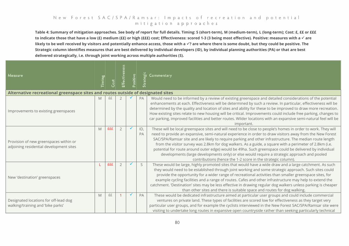
Table 4: Summary of mitigation approaches. See body of report for full details. Timing: S (short-term), M (medium-term), L (long-term); Cost: £, ££ or £££
to indicate those that have a low (£) medium (££) or high (£££) cost; Effectiveness: scored 1-3 (3 being most effective). Positive: measures with a ✓ are
likely to be well received by visitors and potentially enhance access, those with a ✓? are where there is some doubt, but they could be positive. The
Strategic column identifies measures that are best delivered by individual developers (ID), by individual planning authorities (PA) or that are best
delivered strategically, i.e. through joint working across multiple authorities (S).
Alternative recreational greenspace sites and routes outside of designated sites
Improvements to existing greenspaces
M ££ 2 ✓ PA Would need to be informed by a review of existing greenspace and detailed considerations of the potential
enhancements at each. Effectiveness will be determined by such a review. In particular, effectiveness will be
determined by the quality and location of sites and ability for these to be improved to draw more recreation.
How existing sites relate to new housing will be critical. Improvements could include free parking, changes to
car parking, improved facilities and better routes. Wilder locations with an expansive semi-natural feel will be
important.
Provision of new greenspaces within or
adjoining residential development sites
M £££ 2 ✓ ID,
PA
These will be local greenspace sites and will need to be close to people’s homes in order to work. They will
need to provide an expansive, semi-natural experience in order to draw visitors away from the New Forest
SAC/SPA/Ramsar site and are likely to require parking and other infrastructure. The median route length
from the visitor survey was 2.8km for dog walkers. As a guide, a square with a perimeter of 2.8km (i.e.
potential for route around outer edge) would be 49ha. Such greenspace could be delivered by individual
developments (large developments only) or else would require a strategic approach and pooled
contributions (hence the 1-2 score in the strategic column).
New ‘destination’ greenspaces
L £££ 2 ✓ S These would be large, highly promoted sites that would have a wide draw and a large catchment. As such
they would need to be established through joint working and some strategic approach. Such sites could
provide the opportunity for a wider range of recreational activities than smaller greenspace sites, for
example cycling facilities and a range of routes. Cafes and other infrastructure may help to extend the
catchment. ‘Destination’ sites may be less effective in drawing regular dog walkers unless parking is cheaper
than other sites and there is suitable space and routes for dog walking.
Designated locations for off-lead dog
walking/training and ‘bike parks’
M ££ 1 ✓ PA These would be dedicated infrastructure aimed at particular user groups and could include commercial
ventures on private land. These types of facilities are scored low for effectiveness as they target very
particular user groups, and for example the cyclists interviewed in the New Forest SAC/SPA/Ramsar site were
visiting to undertake long routes in expansive open countryside rather than seeking particularly technical
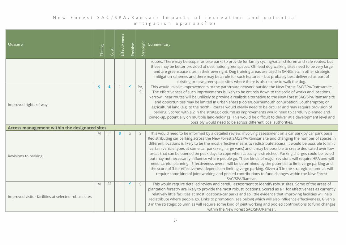
routes. There may be scope for bike parks to provide for family cycling/small children and safe routes, but
these may be better provided at destination greenspaces. Off-lead dog walking sites need to be very large
and are greenspace sites in their own right. Dog training areas are used in SANGs etc in other strategic
mitigation schemes and there may be a role for such features – but probably best delivered as part of
existing or new greenspace sites where there is also scope to walk the dog.
Improved rights of way
S £ 1 ✓ PA,
S
This would involve improvements to the path/route network outside the New Forest SAC/SPA/Ramsarsite.
The effectiveness of such improvements is likely to be entirely down to the scale of works and locations.
Narrow linear routes will be unlikely to provide a realistic alternative to the New Forest SAC/SPA/Ramsar site and opportunities may be limited in urban areas (Poole/Bournemouth conurbation, Southampton) or
agricultural land (e.g. to the north). Routes would ideally need to be circular and may require provision of
parking. Scored with a 2 in the strategic column as improvements would need to carefully planned and
joined-up, potentially on multiple land-holdings. This would be difficult to deliver at a development level and
possibly would need to be across different local authorities.
Access management within the designated sites
Revisions to parking
M ££ 3 x S This would need to be informed by a detailed review, involving assessment on a car park by car park basis.
Redistributing car parking across the New Forest SAC/SPA/Ramsar site and changing the number of spaces in
different locations is likely to be the most effective means to redistribute access. It would be possible to limit
certain vehicle types at some car parks (e.g. large vans) and it may be possible to create dedicated overflow
areas that can be opened on peak days to cope when capacity is stretched. Parking charges could be levied
but may not necessarily influence where people go. These kinds of major revisions will require HRA and will
need careful planning. Effectiveness overall will be determined by the potential to limit verge parking and
the score of 3 for effectiveness depends on limiting verge parking. Given a 3 in the strategic column as will
require some kind of joint working and pooled contributions to fund changes within the New Forest
SAC/SPA/Ramsar.
Improved visitor facilities at selected robust sites
M ££ 1 ✓ S This would require detailed review and careful assessment to identify robust sites. Some of the areas of
plantation forestry are likely to provide the most robust locations. Scored as a 1 for effectiveness as currently
relatively little facilities at most locations/car parks and so little evidence that improving facilities will help
redistribute where people go. Links to promotion (see below) which will also influence effectiveness. Given a
3 in the strategic column as will require some kind of joint working and pooled contributions to fund changes
within the New Forest SAC/SPA/Ramsar.

Management of paths and tracks
S £ 1 ✓? S Scope to add further routes and seek to disperse access. Scored as 1 for effectiveness and it may serve to
simply add more infrastructure and draw more visitors. There may be opportunities in specific locations
where such approaches may work well, for example through the removal of crossing points on streams and
dead-hedging etc., but there would then be a need careful checks and monitoring to ensure paths and desire
lines do not become re-established.
Changes in legislation
M £ 2 x S Depends entirely on the legislation and how enforced, hence the score of 2 for effectiveness. A new traffic
regulation/verge protection order that was able to restrict verge parking would be likely to make a major
difference. Legislation relating to dogs on leads may be difficult to establish.
Educational and communications activities
Better information and interpretation
S £ 2 ✓ S This could be provided in a range of ways, including face-face, on-line or physical infrastructure such as
interpretation panels or signs. Effectiveness will be dependent on the quality and scale of provision. Likely to
be important as a component of any mitigation approach in order to ensure visitors understand the need to
behave in a particular way or the reasoning behind particular interventions. Scored as a 2 for effectiveness as
relatively little evidence that effective in isolation (e.g. Byers 2003, cited in Williams et al., 2019a).
Guided walks and themed events and activities
S £ 1 ✓ S Events etc may draw more visitors and therefore any programme needs to be carefully promoted and
targeted. Face-face contact likely to work well to convey tailored messages and events most likely to work
well with particular audiences (e.g. dog walkers).
Promotion of walking routes in robust locations
S £ 2 ✓ S Effectiveness will depend on finding suitable robust locations, how many robust locations are promoted, how
well the promotion works and the relevant take-up. The visitor survey data provides some insights into the
likely scale, lengths of routes and current route selection (at least at the survey locations).
Activities and projects to encourage health-
enhancing and responsible outdoor recreation
close to where people live
S £ 1 ✓ PA Health-enhancing activities doesn’t necessarily equate to mitigation. Nonetheless, activities and events that
are targeted to existing and new greenspaces may help to raise awareness about these sites and help deflect
access. Effectiveness will depend on the locations, the activities, promotion and likely to be best utilised as
part of a package with other measures (such as the creation/enhancement of green infrastructure).
Face-to-face, on site contact with an increased
number of rangers
S ££ 3 ✓? S Rangers are a fundamental element in other strategic mitigation approaches and widely accepted as a
means to influence and manage visitor behaviour. Ranger time can be focussed at locations with particular
sensitivities or issues and there is scope for wide coverage (Dhanjal‐Adams, Mustin, Possingham, & Fuller,
2016). Rangers can fulfil a range of roles, including watching for fires, promoting responsible access, directing
visitors and showing visitors wildlife. Cost and effectiveness will depend on the number of rangers.
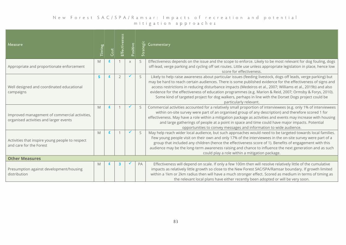
Appropriate and proportionate enforcement
M £ 1 x S Effectiveness depends on the issue and the scope to enforce. Likely to be most relevant for dog fouling, dogs
off-lead, verge parking and cycling off set routes. Little use unless appropriate legislation in place, hence low
score for effectiveness.
Well designed and coordinated educational
campaigns
S £ 2 ✓ S Likely to help raise awareness about particular issues (feeding livestock, dogs off leads, verge parking) but
may be hard to reach certain audiences. There is some published evidence for the effectiveness of signs and
access restrictions in reducing disturbance impacts (Medeiros et al., 2007; Williams et al., 2019b) and also
evidence for the effectiveness of education programmes (e.g. Marion & Reid, 2007; Ormsby & Forys, 2010).
Some kind of targeted project for dog walkers, perhaps in line with the Dorset Dogs project could be
particularly relevant.
Improved management of commercial activities,
organised activities and larger events
M £ 1 ✓ S Commercial activities accounted for a relatively small proportion of interviewees (e.g. only 1% of interviewees
within on-site survey were part of an organised group of any description) and therefore scored 1 for
effectiveness. May have a role within a mitigation package as activities and events may increase with housing
and large gatherings of people at a point in space and time could have major impacts. Potential
opportunities to convey messages and information to wide audience.
Activities that inspire young people to respect
and care for the Forest
M £ 1 ✓ S May help reach wider local audience, but such approaches would need to be targeted towards local families.
Few young people visit on their own and only 17% of the interviewees in the on-site survey were part of a
group that included any children (hence the effectiveness score of 1). Benefits of engagement with this
audience may be the long-term awareness raising and chance to influence the next generation and as such
could play a role within a mitigation package.
Other Measures
Presumption against development/housing
distribution
M £ 3 ✓ PA Effectiveness will depend on scale. If only a few 100m then will resolve relatively little of the cumulative
impacts as relatively little growth so close to the New Forest SAC/SPA/Ramsar boundary. If growth limited
within a 1km or 2km radius then will have a much stronger effect. Scored as medium in terms of timing as
the relevant local plans have either recently been adopted or will be very soon.

Balmer, D. E., Gillings, S., Caffrey, J. M., Swann, B., Downie, I., & Fuller, R. (2013). Bird Atlas
2007-11 the breeding and wintering birds of Britain and Ireland. Thetford, Norfolk:
BTO.
Banks, P. B., & Bryant, J. V. (2007). Four-legged friend of foe? Dog-walking displaces
native birds from natural areas. Biology Letters, 3(6), 611–613.
Beale, C. M., & Monaghan, P. (2004). Human disturbance: people as predation-free
predators? Journal of Applied Ecology, 41(2), 335–343.
Beale, C. M., & Monaghan, P. (2005). Modeling the Effects of Limiting the Number of
Visitors on Failure Rates of Seabird Nests. Conservation Biology, 19, 2015–2019.
Bellamy, P. (2015). Can’t see the wood for the trees! Understanding woodland bird declines
(Case Study No. 17). Sandy, Beds.: RSPB Centre for Conservation Science.
Bellamy, P. E., Burgess, M. D., Mallord, J. W., Cristinacce, A., Orsman, C. J., Davis, T., …
Charman, E. C. (2018). Nest predation and the influence of habitat structure on
nest predation of Wood Warbler Phylloscopus sibilatrix, a ground-nesting forest
passerine. Journal of Ornithology, 159(2), 493–506. doi: 10.1007/s10336-017-1527-
7
Bellefleur, D., Lee, P., & Ronconi, R. A. (2009). The impact of recreational boat traffic on
Marbled Murrelets (Brachyramphus marmoratus). Journal of Environmental
Management, 90(1), 531–538. doi: 10.1016/j.jenvman.2007.12.002
Brambilla, M., Rubolini, D., & Guidali, F. (2004). Rock climbing and Raven Corvus corax
occurrence depress breeding success of cliff-nesting Peregrines Falco
peregrinus. Ardeola, 51(2), 425–430.
Brawn, J., Robinson, S., & III, F. T. (2001). The role of disturbance in the ecology and
conservation of birds. Annual Review of Ecology and Systematics, 32(2001), 251–
276.
Bullock, J. M., & Webb, N. R. (1995). Responses to severe fires in heathland mosaics in
Southern England. Biological Conservation, 73(3), 207–214. doi: 10.1016/0006-
3207(94)00110-C
Cavalli, M., Baladrón, A. V., Isacch, J. P., Biondi, L. M., & Bó, M. S. (2016). Differential risk
perception of rural and urban Burrowing Owls exposed to humans and dogs.
Behavioural Processes, 124, 60–65. doi: 10.1016/j.beproc.2015.12.006

Cavan, G., & McMorrow, J. (2009). Interdisciplinary Research on Ecosystem Services: Fire and
Climate Change in UK Moorlands and Heaths. Summary report prepared for Scottish
Natural Heritage. SNH.
Chatters, C., & Kernohan, R. (2031). Avon Water Studies: Two studies of land-use and land
ownership change in the New Forest National Park. Hampshire and Isle of Wight
Wildlife Trust.
Clements, R. (2019). Dartford Warbler study 2018. In Hampshire Bird Report 2018 (pp.
216–219). Hampshire Ornithological Society.
Cox, J. (1996a). A preliminary assessment of proposed changes in camping and car park
provision in the New Forest [Unpublished report for the New Forest Association
and the Hampshire Wildlife Trust].
Cox, J. (1996b). New Forest Rivers: Policies and Issues [Unpublished report for the
Hampshire and Isle of Wight Wildlife Trust].
Dhanjal‐Adams, K. L., Mustin, K., Possingham, H. P., & Fuller, R. A. (2016). Optimizing
disturbance management for wildlife protection: the enforcement allocation
problem. Journal of Applied Ecology, 53(4), 1215–1224. doi: 10.1111/1365-
2664.12606
Edgar, P. (2002). The effects of public access on amphibians and reptiles. an assessment of
the potential effects of increased public access due to the introduction of the
countryside and rights of way act 2000. Retrieved from CCW Contract Science
website:
file:///S:/reports%20%26%20pdfs/Papers%20linked%20to%20Endnote/Edgar,%2
0public%20access%20on%20Amphibians%20and%20Reptiles%20(CS_478).pdf
Egli, S., Peter, M., Buser, C., Stahel, W., & Ayer, F. (2006). Mushroom picking does not
impair future harvests – results of a long-term study in Switzerland. Biological
Conservation, 129(2), 271–276. doi: 10.1016/j.biocon.2005.10.042
Ellenberg, U., Mattern, T., & Seddon, P. J. (2013). Heart rate responses provide an
objective evaluation of human disturbance stimuli in breeding birds.
Conservation Physiology, 1(1), cot013–cot013. doi: 10.1093/conphys/cot013
Fearnley, H., Hoskin, R., Liley, D., White, J., & Lake, S. (2012). Urban development and the
New Forest SPA. Footprint Ecology/ New Forest National Park Authority.
Fernandez-Juricic, E., Jimenez, M. D., & Lucas, E. (2001). Alert distance as an alternative
measure of bird tolerance to human disturbance: implications for park design.
Environmental Conservation, 3, 263–269.
Glover, J. (2019). Landscapes review: National Parks and AONBs [Independent review
commissioned by the Department for the Environment, Food and Rural Affairs].
DEFRA.
Goater, R. D., Houghton, D., & Temple, C. (2004). The New Forest Breeding Waders Survey
2004; a survey of breeding waders in the New Forest Valley Mires, Hampshire. RSPB /
New Forest LIFE partnership.
Grant, M. J., & Edwards, M. E. (2008). Conserving idealized landscapes: past history,
public perception and future management in the New Forest (UK). Vegetation
History and Archaeobotany, 17(5), 551–562. doi: 10.1007/s00334-007-0100-3
Hampshire Ornithological Society. (2015a). Hampshire Bird Atlas 2007-2012 (J. Eyre, Ed.).
Hampshire Ornithological Society.
Hampshire Ornithological Society. (2015b). Hampshire Bird Report 2013. Hampshire
Ornithological Society.
Hampshire Ornithological Society. (2015c). Hampshire Bird Report 2014. HAMPSHIRE
ORNITHOLOGICAL.
Hampshire Ornithological Society. (2016). Hampshire Bird Report 2015.
Hampshire Ornithological Society. (2018). Hampshire Bird Report 2017. Dorchester.
Hampshire Ornithological Society. (2020). Woodlark Survey 2019. Unpublished report by
the Hampshire Ornithological Society for the Verderers of the New Forest.
Hill, D., Hockin, D., Price, D., Tucker, G., Morris, R., & Treweek, J. (1997). Bird disturbance:
Improving the quality and utility of disturbance research. Journal of Applied
Ecology, 34((2)), 275–288.
Hockin, D., Ounsted, M., Gorman, M., Hill, D., Keller, V., & Barker, M. A. (1992).
Examination of the effects of Disturbance on birds with reference to its
importance in Ecological Assessments. Journal of Environmental Management, 36,
253–286.
Holling, M., & Rare Breeding Birds Panel. (2018). Rare breeding birds in the UK in 2016.
British Birds, 111(November), 644–694.
HOS. (2019). Wader Survey 2019. Unpublished report by the Hampshire Ornithological
Society for the Verderers of the New Forest.
ICF GHK. (2013). The economic impact of Natural England’s National Nature Reserves
(Natural England Commissioned Report No. NECR131).
ICRT. (2011). The Economic Potential of Nature Tourism in Eastern Yorkshire (p. 61).
Retrieved from http://mediafiles.thedms.co.uk/Publication/YS-
EY/cms/pdf/YNT%20ICRT%20Report,%20Nature%20Tourism%20in%20Eastern%2
0Yorkshire.pdf
Jackson, S. (2018). Survey and assessment of Nightjar Caprimulgus europaeus status in the
New Forest. Unpublished report by Arcadian Ecology for the Verderers of the New
Forest.
Kays, R., Parsons, A. W., Baker, M. C., Kalies, E. L., Forrester, T., Costello, R., … McShea, W.
J. (2017). Does hunting or hiking affect wildlife communities in protected areas?
Journal of Applied Ecology, 54(1), 242–252. doi: 10.1111/1365-2664.12700
Keniger, L. E., Gaston, K. J., Irvine, K. N., & Fuller, R. A. (2013). What are the Benefits of
Interacting with Nature? International Journal of Environmental Research and Public
Health, 10(3), 913–935. doi: 10.3390/ijerph10030913
Lafferty, K. (2001). Birds at a Southern California beach: seasonality, habitat use and
disturbance by human activity. Biodiversity and Conservation, 10(11), 1949–1962.
Lee, A. C. K., & Maheswaran, R. (2011). The health benefits of urban green spaces: a
review of the evidence. Journal of Public Health, 33(2), 212–222. doi:
10.1093/pubmed/fdq068
Legg, C. J., & Davies, M. (2009). What determines fire occurrence, fire behaviour and fire
effects in heathlands? Proceedings of the 10th National Heathland Conference -
Managing Heathlands in the Face of Climate Change, 45–55. York: Natural England
Commissioned Report NECR014.
Liddle, M. J. (1997). Recreation Ecology. London: Chapman & Hall.
Liley, D., & Fearnley, H. (2012). Poole Harbour Disturbance Study. Footprint Ecology /
Natural England.
Liley, D., & Fearnley, H. (2014). Trends in Nightjar, Woodlark and Dartford Warbler on the
Dorset Heaths 1991-2013. Footprint Ecology / Birds of Poole Harbour.
Liley, D., Lake, S., Underhill-Day, J., Sharp, J., White, J., Hoskin, R., … Fearnley, H. (2010a).
Welsh Seasonal Habitat Vulnerability Review. Footprint Ecology / CCW.
Liley, D., Lake, S., Underhill-Day, J., Sharp, J., White, J., Hoskin, R., … Fearnley, H. (2010b).
Welsh Seasonal Habitat Vulnerability Review. Footprint Ecology / CCW.
Liley, D., Stillman, R., Austin, G., & Panter, C. (2016). Advice on how to evaluate the
effectiveness of the Solent Recreation Mitigation Strategy (Unpub. No. 288).
Footprint Ecology / Solent Recreation Partnership.
Liley, Durwyn, & Sutherland, W. J. (2007). Predicting the population consequences of
human disturbance for Ringed Plovers Charadrius hiaticula: a game theory
approach. Ibis, 149(s1), 82–94. doi: doi:10.1111/j.1474-919X.2007.00664.x
Lowen, J., Liley, D., Underhill-Day, J., & Whitehouse, A. T. (2008). Access and Nature
Conservation Reconciliation: supplementary guidance for England. Retrieved from
internal-pdf://NECR013 Access and N C Reconciliation - Supp Guidance-
2802587904/NECR013 Access and N C Reconciliation - Supp Guidance.pdf
Mallord, J. W., Smith, K. W., Bellamy, P. E., Charman, E. C., & Gregory, R. D. (2016). Are
changes in breeding habitat responsible for recent population changes of long-
distance migrant birds? Bird Study, 63(2), 250–261. doi:
10.1080/00063657.2016.1182467
Marion, J. L., & Reid, S. E. (2007). Minimising Visitor Impacts to Protected Areas: The
Efficacy of Low Impact Education Programmes. Journal of Sustainable Tourism,
15(1), 5–27. doi: 10.2167/jost593.0
Martin, R. H., Butler, D. R., & Klier, J. (2018). The influence of tire size on bicycle impacts
to soil and vegetation. Journal of Outdoor Recreation and Tourism, 24, 52–58. doi:
10.1016/j.jort.2018.08.002
Marzluff, J. M., & Neatherlin, E. (2006). Corvid responses to human settlements and
campgrounds: causes, consequences and challenges for conservation. Biological
Conservation, 130, 301–314.
Medeiros, R., Ramosa, J. A., Paivaa, V. H., Almeidac, A., Pedroa, P., & Antunes, S. (2007).
Signage reduces the impact of human disturbance on little tern nesting success
in Portugal. Biological Conservation, 135(1), 99–106.
Messenger, A., & Roome, M. (2007). The breeding population of the Hobby in
Derbyshire. British Birds, 100, 594–608.
Mulero-Pázmány, M., Jenni-Eiermann, S., Strebel, N., Sattler, T., Negro, J. J., & Tablado, Z.
(2017). Unmanned aircraft systems as a new source of disturbance for wildlife: A
systematic review. PLOS ONE, 12(6), e0178448. doi:
10.1371/journal.pone.0178448
New Forest Joint Steering Committee. (1971). Conservation of the New Forest.
New Forest npa. (2016). New Forest State of the Park Report 2016. New Forest National
Park Authority.
NFNPA. (2010). New Forest National Park Recreation Management Strategy 2010-2030. New
Norest National Park Authority.
Ormsby, A. A., & Forys, E. A. (2010). The Effects of an Education Campaign on Beach
User Perceptions of Beach-Nesting Birds in Pinellas County, Florida. Human
Dimensions of Wildlife, 15(2), 119–128. doi: 10.1080/10871200903428366
Panter, C., & Caals, Z. (in prep). Urban Heaths Partnership Annual Monitoring Report 2018-
19. Unpublished report for the Urban Heaths Partnership.
Panter, C., Lake, S., & Liley, D. (2016). Southern Damselfly monitoring results 2015 and
2016. Footprint Ecology/Natural England.
Panter, C., & Liley, D. (2017). Update on the Dorset Heathland Implementation Group
Monitoring Framework. Footprint Ecology on behalf of the Urban Heaths
Partnerhsip.
Pascoe, C. (n.d.). Factors Affecting the Distribution of Spiranthes spiralis and Gentianella
campestris on Wilverley Plain in the New Forest (BSc). University of Reading,
Reading UK.
Pienkowski, M. J. (1984). Breeding biology and population dynamics of Ringed Plovers
Charadrius hiaticula in Britain and Greenland: nest predation as a possible factor
limiting distribution and time of breeding. Journal of the Zoological Society of
London, 202, 83–114.
Pretty, J., Griffin, M., Peacock, J., Hine, R., Selens, M., & South, N. (2005). A countryside for
health and well-being: the physical and mental health benefits of green exercise.
Countryside Recreation, 13(1), 2–7.
Rand, M., & Mundell, A. R. G. (2011). Hampshire Rare Plant Register. Trollius Publications.
Richardson, M., Cormack, A., McRobert, L., & Underhill, R. (2016). 30 Days Wild:
Development and Evaluation of a Large-Scale Nature Engagement Campaign to
Improve Well-Being. PLOS ONE, 11(2), e0149777. doi:
10.1371/journal.pone.0149777
Roberts, S. J., Lewis, J. M. S., & Williams, I. T. (1999). Breeding European Honey buzzards
in Britain. British Birds, 92(7), 326–345.
Rose, R., & Clarke, R. (2005). Urban impacts on Dorset heathlands: Analysis of the heathland
questionnaire survey and heathland fires incidence data sets. Peterborough: English
Nature.
Ross, K., Liley, D., Austin, G., Clarke, R. T., Burton, N. H., Stillman, R. A., … Underhill-Day, J.
(2014). Housing development and estuaries in England: developing methodologies for
assessing the impacts of disturbance to non-breeding waterfowl. Footprint Ecology,
unpublished report for Natural England.
RPS. (2014). New Forest National Park breeding wader survey [Unpublished report for the
New Forest National Park Authority].
Sandifer, P. A., Sutton-Grier, A. E., & Ward, B. P. (2015). Exploring connections among
nature, biodiversity, ecosystem services, and human health and well-being:
Opportunities to enhance health and biodiversity conservation. Ecosystem
Services, 12, 1–15. doi: 10.1016/j.ecoser.2014.12.007
Schmitt, C., Oetken, M., Dittberner, O., Wagner, M., & Oehlmann, J. (2008). Endocrine
modulation and toxic effects of two commonly used UV screens on the aquatic
invertebrates Potamopyrgus antipodarum and Lumbriculus variegatus.
Environmental Pollution, 152(2), 322–329. doi: 10.1016/j.envpol.2007.06.031
Sharp, J., Lowen, J., & Liley, D. (2008). Changing patterns of visitor numbers within the New
Forest National Park, with particular reference to the New Forest SPA [Footprint
Ecology / New Forest National Park Authority].
Showler, D. (2010). What is the impact of public access on the breeding success of ground-
nesting and cliff-nesting birds (Systematic Review; Completed Review Report No.
CEE 05-10). Retrieved from Collaboration for Environmental Evidence, Bangor
University website: http://www.environmentalevidence.org/Documents/SR16.pdf
Smith-Castro, J. R., & Rodewald, A. D. (2010). Behavioral responses of nesting birds to
human disturbance along recreational trails. Journal of Field Ornithology, 81(2),
130–138. doi: 10.1111/j.1557-9263.2010.00270.x
Steven, R., Pickering, C., & Guy Castley, J. (2011). A review of the impacts of nature based
recreation on birds. Journal of Environmental Management, 92(10), 2287–2294. doi:
10.1016/j.jenvman.2011.05.005
Tantram, D., Boobyer, M., & Kirby, J. (1999). Monitoring heathland fires in Dorset: Phase 2.
Northampton: Report to DETR.
Taylor, E. C., Green, R. E., & Perrins, J. (2007). Stone-curlews Burhinus oedicnemus and
recreational disturbance: developing a management tool for access. Ibis, 149, 37–
44. doi: 10.1111/j.1474-919X.2007.00645.x
The Land Trust. (2018). The Economic Value of Greenspaces. The Land Trust.
Thiel, D., Jenni-Eiermann, S., Palme, R., & Jenni, L. (2011). Winter tourism increases stress
hormone levels in the Capercaillie Tetrao urogallus. Ibis, 153(1), 122–133. doi:
10.1111/j.1474-919X.2010.01083.x
Thomas, K., Kvitek, R. G., & Bretz, C. (2003). Effects of human activity on the foraging
behavior of sanderlings Calidris alba. Biological Conservation, 109(1), 67–71. doi:
10.1016/S0006-3207(02)00137-4
Tubbs, C. R. (2001). The New Forest: History, Ecology and Conservation. Lyndhurst,
Hampshire: New Forest Ninth Centenary Trust, New Forest Museum.
Underhill-Day, J. C. (2005). A literature review of urban effects on lowland heaths and their
wildlife. Retrieved from English Nature website: internal-pdf://EN RR 623, John
Day literature review of urban effects-3794804480/EN RR 623, John Day literature
review of urban effects.pdf
Whitfield, D. P., Ruddock, M., & Bullman, R. (2008). Expert opinion as a tool for
quantifying bird tolerance to human disturbance. Biological Conservation, 141(11),
2708–2717.
Williams, D. R., Child, M. F., Dicks, L. V., Ockendon, N., Pople, R. G., Showler, D. A., …
Sutherland, W. J. (2019a). Raise awareness amongst the general public through
campaigns and public information. In What works in Conservation. Retrieved from
https://www.conservationevidence.com/actions/309
Williams, D. R., Child, M. F., Dicks, L. V., Ockendon, N., Pople, R. G., Showler, D. A., …
Sutherland, W. J. (2019b). Use signs and access restrictions to reduce disturbance
at nest sites. In What works in Conservation. Retrieved from
https://www.conservationevidence.com/actions/309
Wright, R. N., & Westerhoff, D. V. (2001). New Forest SAC management plan. Lyndhurst:
English Nature.
Wynn, R., & Page, A. (2018). New Forest Curlew Project: 2018 Results.
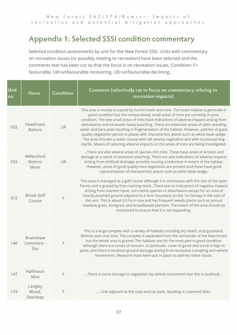
Selected condition assessments by unit for the New Forest SSSI. Units with commentary
on recreation issues (or possibly relating to recreation) have been selected and the
comments text has been cut so that the focus is on recreation issues. Condition: F=
favourable, UR=unfavourable recovering, UD=unfavourable declining,
032 Deadmans
Bottom UR
This area is mostly occupied by humid heath and mire. The heath habitat is generally in
good condition but the comparatively small areas of mire are currently in poor
condition. The two small areas of mire have indications of adverse impacts arising from
disturbance and excessive heavy poaching. There are extensive areas of open standing
water and bare peat resulting in fragmentation of the habitat. However, patches of good
quality vegetation persist in places with characteristic plants such as white beak-sedge.
The area includes a water course with tall swamp vegetation and with occasional bog
myrtle. Means of reducing adverse impacts on the areas of mire are being investigated.
033
Millersford
Bottom
Mires
UR
…There are also several areas of species-rich mire. These have areas of erosion and
damage as a result of excessive poaching. There are also indications of adverse impacts
arising from artificial drainage, possibly causing a reduction in extent of the habitat.
However, areas of good quality mire vegetation are present and these have good
representation of characteristic plants such as white beak-sedge.
072 Brook Golf
Course F
This area is managed as a golf course although it is continuous with the rest of the open
Forest and is grazed by free-roaming stock…There are no indications of negative impacts
arising from nutrient input, non-native species or disturbance except for an area of
heavily poached ground adjacent to a farm boundary on the 1st fairway in the east of
the unit. This is about 0.5 ha in size and has frequent weedy plants such as annual
meadow grass, knotgrass and broadleaved plantain. The extent of the area should be
monitored to ensure that it is not expanding.
146
Bramshaw
Commons -
Dry
F
This is a large complex with a variety of habitats including dry heath, acid grassland,
Molinia lawn and mire. The complex is separated from the remainder of the New Forest
but the whole area is grazed. The habitats are for the most part in good condition
although there are issues of concern. In particular, cover of gorse and scrub is high in
parts, and there is localised ground damage arising from excessive trampling and vehicle
movements. Measures have been put in place to address these issues.
147 Halfmoon
Mire F …There is some damage to vegetation by vehicle movements but this is localised….
174
Langley
Wood,
Deerleap
F …. Unit adjacent to the road and car park, resulting in scattered litter.
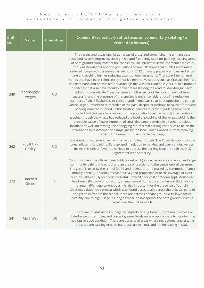
249 Mockbeggar
Verges UD
The verges and occasional larger areas of grassland comprising the unit are best
described as semi improved, close grazed and frequently used for parking, causing areas
of bare ground along most of the roadsides. The interest is in the chamomile which is
frequent throughout and the populations of small fleabane that in 2014 were much
reduced compared to a survey carried out in 2012. In many places brambles and scrub
are encroaching further reducing extent of open grassland. There are 2 ephemeral
ponds that have been colonised by invasive non-native species such as Crassula helmsii ,
still dominant, and parrots feather although this was not evident in 2014. Also a number
of ditches that also have monkey flower at least along the road to Mockbeggar Farm.
Solutions to eradicate Crassula helmsii in other parts of the forest have not been
successful and the presence of this species is under consideration. The reduction in
numbers of small fleabane is of concern and in one particular spot opposite the garage
where large numbers were recorded in the past, despite or perhaps because of frequent
parking, none were found. In this location barriers to prevent parking have been
installed and this may be a reason for the population crash. A reduction in livestock
grazing through the village has reduced the level of poaching of the verges which is the
probable cause of lower numbers of small fleabane recorded in all other previous
locations as well. Increasing use of hogging for informal parking continues to be on the
increase despite information campaigns by the local Parish Council, further reducing
extent. Unit remains unfavourable declining.
262 Royal Oak
Gorley UD
Linear unit of settlement lawn with a road running through. The Royal Oak pub uses the
area adjacent for parking. Bare ground in relation to parking and over-running verges
makes this unit unfavourable. Need to address the parking issue through the HLS
agreement with Somerley.
273 Hatchett
Green F
This unit covers the village green (with cricket pitch) as well as an area of woodland edge
community behind the school and an area of grassland to the south west of the green.
The green is used by the school for PE and recreation, and grazed by commoners’ stock
(mostly ponies).The acid grassland has a good proportion of herbs (average of 47%),
such as Cat’s-ear (Hypochaeris radicata), Hawkbit species (Leontodon spp), Mouse-ear
hawkweed (Pilosella officinarum), Sheep’s sorrel (Rumex acetosella) and Buck’s-horn
plantain (Plantago coronopus). It is also important for the presence of Upright
Chickweed (Moenchia erecta) which was found occasionally across the unit. On parts of
the green in front of the school, there are patches of bare ground with low species
diversity due to high usage. As long as these do not spread, the bare ground is within
target over the unit as whole.
341 Ma 5 Wet UR
….There are no indications of negative impacts arising from nutrient input, excessive
disturbance or trampling and current grazing levels appear appropriate to maintain the
habitats in good condition. There are occasional areas where recreational and grazing
pressure are causing erosion but these are minimal and not increasing in scale.
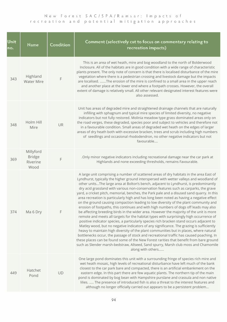
343 Highland
Water Mire F
This is an area of wet heath, mire and bog woodland to the north of Bolderwood
Inclosure. All of the habitats are in good condition with a wide range of characteristic
plants present. The only note of concern is that there is localised disturbance of the mire
vegetation where there is a pedestrian crossing and livestock damage but the impacts
are localised. …….The erosion of the mire is confined to a small area in the upper reach
and another place at the lower end where a footpath crosses. However, the overall
extent of damage is relatively small. All other relevant designated interest features were
also assessed.
348 Holm Hill
Mire UR
Unit has areas of degraded mire and straightened drainage channels that are naturally
infilling with sphagnum and typical mire species of limited diversity, no negative
indicators but not fully restored. Molinia meadow type grass dominated areas only on
the road verges, these degraded, species poor and subject to vehicles and therefore not
in a favourable condition. Small areas of degraded wet heath on the edges of larger
areas of dry heath both with excessive bracken, trees and scrub including high numbers
of seedlings and occasional rhododendron, no other negative indicators but not
favourable….
369
Millyford
Bridge
Riverine
Wood
F .Only minor negative indicators including recreational damage near the car park at
Highlands and none exceeding thresholds, remains Favourable.
374 Ma 6 Dry F
A large unit comprising a number of scattered areas of dry habitats in the area East of
Lyndhurst, typically the higher ground interspersed with wetter valleys and woodland of
other units…The large area at Bolton’s bench, adjacent to Lyndhurst, is predominantly
dry acid grassland with various non-conservation features such as carparks, the grave
yard, a cricket pitch, memorial, benches, the Park pale and a disused sand quarry. In this
area recreation is particularly high and has long been noted as having a negative effect
on the ground causing compaction leading to low diversity of the plant community and
erosion of footpaths, this continues and with high numbers of dogs off leads may also
be affecting breeding birds in the wider area. However the majority of the unit is more
remote and meets all targets for the habitat types with surprisingly high occurrence of
positive indicator species, a particularly species rich bracken stand occurs adjacent to
Matley wood, but no negative indicators of any significance. The grazing is sufficiently
heavy to maintain high diversity of the plant communities but in places, where natural
bottlenecks occur, the passage of stock and recreational traffic has caused poaching. In
these places can be found some of the New Forest rarities that benefit from bare ground
such as Slender marsh-bedstraw, Allseed, Sand spurry, Marsh club moss and Chamomile
along with others……
449 Hatchet
Pond UD
One large pond dominates this unit with a surrounding fringe of species rich mire and
wet heath mosaic, high levels of recreational disturbance have left much of the bank
closest to the car park bare and compacted, there is an artificial embankment on the
eastern edge. In this part there are few aquatic plants. The northern tip of the main
pond is dominated by bog bean with Hampshire purslane and crassula and non native
lilies. ….. The presence of introduced fish is also a threat to the interest features and
although no longer officially carried out appears to be a persistent problem…

480 Balmer
Lawn F
The majority of the unit is open lawn with standard or scattered trees and shrubs in
places especially to the South towards Jacks Wood; considered as site fabric, scrub has
been reduced recently and all add structure. The area is the best example of the tussock
mounds common throughout the New Forest and considered to be remnants of wet
heath that are particularly dense in places here... In places there are indicators that
recreational use is having a negative effect on diversity especially close to the campsite
from trampling and BBQs…
529 Malborough
Deeps UR
…… There is a small area of wet Molinia meadow in the South East that is currently little
more than a wide ride due to the frequent willows that are collapsing into the open
space. This in combination with the very wet ground has led to high levels of poaching
and disturbance. There is a good range of positive indicator species of Molinia Meadow
and no other negative indicators. The water course draining from the adjacent enclosure
unit 538 appears to have been modified in the past but is naturalising well but past spoil
banks are affecting the hydrology and exacerbating the poaching on the adjacent
grassland. Unit remains unfavourable due to the high levels of poaching caused by the
willows narrowing the main ride and high recreational use.
571
Hollands
Wood
Campsite
UD
This area of extensively grazed broadleaved woodland is largely occupied by a heavily
used campsite with associated toilet, waste disposal & kitchen facilities provided on site.
The whole area is subject to very high visitor pressure and high levels of trampling,
removal of dead wood and disturbance of wildlife. There are numerous indications of
damaging impacts on the special interest features. The nature conservation value of the
area is consequently low. The canopy of the woodland is predominantly mature oak.
There are few signs of young trees or natural regeneration despite the open canopy.
There are also a large number of mature birch. There is very little dead wood present.
The understory is poorly developed and consists of widely scattered sallow, hawthorn
and holly. The ground layer has widely spaced patches of bramble and bracken but is
otherwise dominated by grasses tolerant of heavy trampling and ruderal species. There
are very few nectar sources. The majority of the area is subject to heavy trampling and
compaction, and there is a lot of bare ground. The ground vegetation in the open areas
is heavily modified and has few of the species typically associated with New Forest lawns
or acid grassland. In addition to the above, all additional designated features have been
considered and assessed.