thomson river basin may 2013 - srw
TRANSCRIPT

Introduction
Southern Rural Water is the water corporation responsible for administering and enforcing the Thomson River Basin Local Management Plan (LMP).
The purpose of the Thomson River Basin LMP is to: • document the management objectives for the system • explain to licence holders (and the broader community) the specific management
objectives and arrangements for their water resource and the rules that apply to them as users of that resource
• clarify water sharing arrangements for all users and the environment, including environmental flow requirements
• document any limits, including water use caps, permissible consumptive volumes or extraction limits that apply to the system.
Management objectives
The objective of the LMP is to ensure the equitable sharing of water between users and the environment and the long-term sustainability of the resource.
Water systems covered
The LMP covers all the rivers and creeks located within the Thomson River Basin, which includes:
Thomson Catchment Macalister Catchment Avon Catchment
Aberfeldy River Carters Creek Avon River
Back Creek Newry Creek Freestone Creek
Boggy Creek Macalister River Upper Nuntin Creek
Coopers Creek Stony Creek Perry River
Lavers Creek Wellington River Valencia Creek
Stringers Creek
Wickhams Creek
Thomson River Basin May 2013

The Thomson River Basin is shown in the map below.

Catchment information
The Thomson Basin which consists of the Thomson, Latrobe and Avon River catchments contains some of Victoria’s most significant river systems and the demand on these freshwater resources is considerable. Located in the Gippsland region of Victoria, these three river systems form the total catchment of Lake Wellington, the western-most of the Gippsland Lakes. The nation’s largest pulp and paper mill, most of the State’s power industry, much of Melbourne’s water supply and the State’s second largest irrigation district fall within their boundaries.
The Thomson River system has two major branches: the Thomson and the Macalister Rivers. With a combined catchment area of 3660km2, it constitutes approximately 17% of the total catchment of the Gippsland Lakes. The Thomson catchment has a temperate climate. Rainfall ranges from 500 to 600mm on the coastal plains to greater than 1400mm in the steep mountain and hill regions of the divide.
The Avon River catchment has a surface area of approximately 2000km2, which comprises about 9.6% of the total catchment area of the Gippsland Lakes. The Avon River rises on the slopes of Mount Wellington in the eastern highlands and flows south to Lake Wellington. The major tributaries of the Avon River include Valencia Creek and Freestone Creek. The Perry River is a minor tributary that joins the Avon River just before it flows into Lake Wellington. Mean annual rainfall varies from more than 1400mm in the highland parts of the catchment to about 600mm around Stratford and Lake Wellington.
Water entitlements
Licence allocations in the Thomson River Basin, which includes the Thomson River Catchment, Macalister River Catchment and the Avon River Catchment are:
Licence Type Number of Licences Volume (ML)
Irrigation* - direct 272 16,006.3
Irrigation - winterfill 10 108.7
Registration** 113 3,145.2
Domestic and Stock 44 103.4
Commercial / Industrial 11 3,423.5
Dairy 2 8.8
Total 452 22,795.9
* Includes amalgamated D&S and Commercial licences **Includes Dairy and Commercial licence

General rules
Licences in the Thomson River Basin are managed in accordance with the Water Act 1989 and Policies for Managing Take and Use Licences. A copy of these policies can be found at:
http://waterregister.vic.gov.au/Public/TakeAndUseLicences.aspx
The general rules for licences in the Thomson River Basin are as follows:
New licences
• The Thomson River Basin is fully allocated, so no new licences can be issued. • The permissible consumptive volume for the Thomson Basin is 460,430ML.
Metering
• Diversions are metered and licence holders must not use more than their licensed volume.
• Meters are installed on all active licences of 10ML or greater or all new licences regardless of the volume.
• Meters are read at least twice per year or upon request.
Restrictions
• Take and use licences allow for Southern Rural Water to roster and restrict extraction during periods of low water availability. Restrictions will be applied by Southern Rural Water as required. Notifications will be provided to licence holders in advance of their implementation.
Transfers
• Temporary transfers of a licence (or part of a licence) can be for up to 5 years, and conclude at the end of the water season (30 June).
• Permanent or temporary transfers of a direct stream (all-year licence) may only be approved if:
o the licence will be transferred to a downstream user, or o the licence is issued to the buyer as a winterfill licence
• A winterfill licence cannot be transferred to be a direct stream (all-year licence).
Renewals
• Licences are renewed in accordance with the Water Act 1989 and Policies for Managing Take and Use Licences.
The general rules apply to all licences in the Thomson River Basin, unless otherwise stated in the system specific rules.

System specific rules
Some systems within the Thomson River Basin require more specific management rules that address rostering, restrictions and trade. In the Avon River Catchment specific rules exist for the following systems:
• Avon River - refer to appendix 1 • Valencia Creek - refer to appendix 2
Annual reporting
Southern Rural Water produces Local Water Reports for each river basin. These reports include information on licences, water use and seasonal conditions. A copy is sent to each licence holder each year.
Consultation and review
SRW will consult with licence holders and relevant stakeholders before making changes to the Local Management Plan, other than administrative changes or clarifications.
The Local Management Plan will be reviewed every 5 years, unless an update is required sooner.
References
• Department Primary Industries – Victorian Resources Online • Victorian Water Accounts
Contact details
For general information call or visit
1300 139 510
www.srw.com.au

Appendix 1 Avon River Rules
Area Description
These rules apply to all Avon River irrigation licence holders downstream of the Channels Gauge Site, as shown below.

Licences
Licence Type Number of Licences Volume (ML)
Direct Pumping 73 7605.6
Conditional 29 2036.4
Winterfill 5 709.6
Commercial 1 2.0
Dairy 1 6.6
Domestic & Stock 18 39.6
Management of Licences
The Avon River is currently divided into four independent sections to assist with management, as flows within the River can vary significantly from the top of the catchment to the bottom, depending on inflows. The river is divided into the following:
Section No. Section Description Gauging
Station Used
1 Upper Avon catchment, including the Valencia Creek, to the Low Level Bridge at the township of Valencia Creek.
Channels
2 Between the Low Level Bridge and the Bushy Park Bridge, including the Freestone Creek.
Stratford
Highway
Bridge
3A Between the Bushy Park Bridge and the Highway Bridge at Stratford.
Stratford
Highway
Bridge
3B Downstream of the Highway Bridge, including the Perry River.
Stratford
Highway
Bridge

Southern Rural Water utilises the Channels Gauging Station to manage Section 1 of the Avon River and the Stratford Highway Bridge Gauging Station to manage Sections 2, 3A and 3B.
Avon River Section 1 - Restriction triggers for each stage of restriction
Restriction Stages
Trigger Value for Introduction of Next Stage of Restriction
(Channels Gauging Station)
Percentage Reduction
Stage 1 (Roster)
30ML per day 0%
Stage 2 20ML per day 25%
Stage 3 15ML per day 50%
Stage 4 10ML per day 75%
Ban <5 ML per day 100%
Avon River Sections 2, 3A & 3B - Restriction triggers for each stage of restriction
Restriction Stages
Trigger Value for Introduction of Next Stage of Restriction
(Stratford Highway Bridge Gauging Station)
Percentage Reduction
Stage 1 (Roster)
30ML per day 0%
Stage 2 25ML per day 25%
Stage 3 20ML per day 50%
Stage 4 15ML per day 75%
Ban <10 ML per day 100%
Irrigator’s rosters are updated as required and are posted or emailed out to each irrigator in early September each year. When rosters and restrictions are introduced (usually commencing from October through to May) an initial phone call is made to each irrigator advising them that rosters & restrictions have commenced. From then on it is the irrigator’s

responsibility to phone the 1300 654 043 telephone hotline on a daily basis to confirm restriction levels. Any changes to restriction levels on the hotline are made by 9am.
Compliance Points
Southern Rural Water currently manages the Avon River using the following Gauging Stations:
Gauge Site Name Site No. Used for
Channels 225224 Rosters & Restrictions for Section 1
Millers 225255 Only used to monitor flow
Stratford 225201 Rosters & Restrictions for Sections 2, 3A & 3B
Transfers
• Temporary transfers of a licence (or part of a licence) can be for up to 5 years, and conclude at the end of the water season (30 June).
• Permanent or temporary transfers of a direct stream (all-year licence) may only be approved if:
o the licence will be transferred to a downstream user, or o the licence is issued to the buyer as a winterfill licence
• A winterfill licence cannot be transferred to be a direct stream (all-year licence).
Consultation
Southern Rural Water liaises with the customers from the catchment as the need arises.
Review
These rules will be reviewed every five years, unless an update is required sooner.

Appendix 2 Valencia Creek Rules
Area Description
These rules apply to all Valencia Creek irrigation licence holders downstream of the Gillios Road Gauge Site, as shown below.
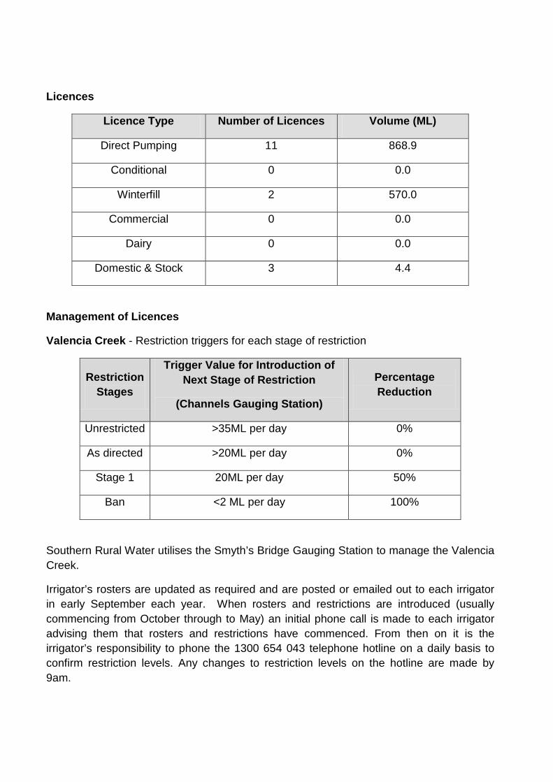
Licences
Licence Type Number of Licences Volume (ML)
Direct Pumping 11 868.9
Conditional 0 0.0
Winterfill 2 570.0
Commercial 0 0.0
Dairy 0 0.0
Domestic & Stock 3 4.4
Management of Licences
Valencia Creek - Restriction triggers for each stage of restriction
Restriction Stages
Trigger Value for Introduction of Next Stage of Restriction
(Channels Gauging Station)
Percentage Reduction
Unrestricted >35ML per day 0%
As directed >20ML per day 0%
Stage 1 20ML per day 50%
Ban <2 ML per day 100%
Southern Rural Water utilises the Smyth’s Bridge Gauging Station to manage the Valencia Creek.
Irrigator’s rosters are updated as required and are posted or emailed out to each irrigator in early September each year. When rosters and restrictions are introduced (usually commencing from October through to May) an initial phone call is made to each irrigator advising them that rosters and restrictions have commenced. From then on it is the irrigator’s responsibility to phone the 1300 654 043 telephone hotline on a daily basis to confirm restriction levels. Any changes to restriction levels on the hotline are made by 9am.

Compliance Points
Southern Rural Water currently manages the Valencia Creek using the following Gauging Stations;
Gauge Site Name Site No. Used for
Gillios Rd 225223 Only used to monitor flow
Smyth’s Rd 225249 Rosters & Restrictions for
all Licences
Transfers
• Temporary transfers of a licence (or part of a licence) can be for up to 5 years, and conclude at the end of the water season (30 June).
• Permanent or temporary transfers of a direct stream (all-year licence) may only be approved if:
o the licence will be transferred to a downstream user, or o the licence is issued to the buyer as a winterfill licence
• A winterfill licence cannot be transferred to be a direct stream (all-year licence).
Consultation
Southern Rural Water liaises with the customers from the catchment as the need arises.
Review
These rules will be reviewed every five years, unless an update is required sooner.