thunderstorms 1. three conditions are needed: 1) abundant source of moisture in the lower atmosphere...
TRANSCRIPT

Thunderstorms
1

Three Conditions are needed:• 1) Abundant source of moisture in the lower atmosphere
• 2) Moisture condenses, releasing latent heat. Latent heat keeps the cloud warmer.
• then the air around it. Keeps the upward motion going to the
• inside of the cloud.• 3) Portions of the atmosphere needs to be unstable.
2

Limits to Growth
Three conditions need to meet:• · Air keeps rising• · More moisture condensing and releases latent heat
• · Continues until rising air reaches stable air and growth stops
• *Most cumulonimbus clouds grow to the height of 18,000 meters.
• *Most thunderstorms last 20 - 30 minutes with a diameter of 24
• kilometers
3

Air Mass Thunderstorm
• Classification by the lift mechanisms. • Air lifted upward due to the unequal heating of the earth within one air mass. •Maximum heating occurs during mid-afternoon - optimum time for those storms.
4

Air Mass Thunderstorm
5

Air Mass Thunderstorm
6
Two common thunderstorms
1) Mountain thunderstorms - air mass rises over mountains (orographic lifting)
7

Sea breeze thunderstorm
• - local air mass thunderstorm caused by the temperature - the difference between land and water
8

Frontal Thunderstorms• Produced by advancing cold front and they meet the warm fronts. Upward motion produces a line of thunderstorms.
• Initial lift comes from the cold front, why? Air is not dependent on day time heating - occurs at night!
9

Formation of frontal Thunderstorm
10

Frontal Thunderstorm
11

Uplifting
12

Warm Fronts
• Can develop thunderstorms. When the warm front slides up and over a cold front within stable air -
• mild thunderstorm.
13
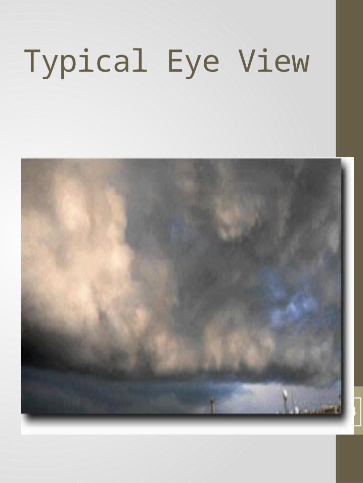
Typical Eye View
14

Warm Front
15

Sea Breezes can cause thunderstorms
16

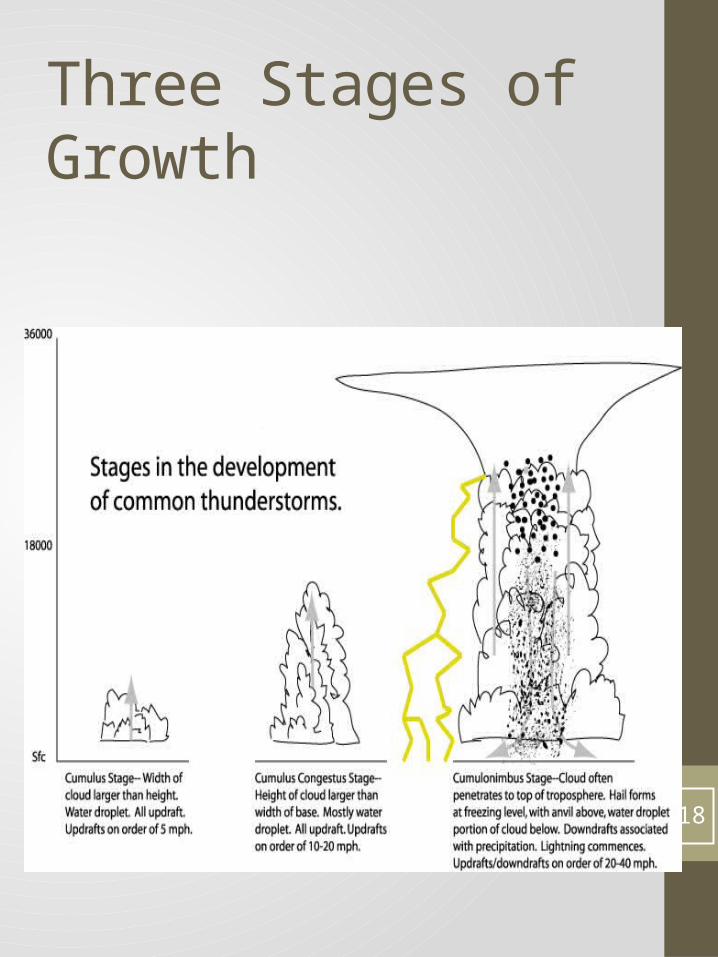
Thunderstorm development• Three stages of development - Stages classified by the direction of air movement
17
Three Stages of Growth
18

Cumulus Stage
• 1) a. Begins with thermals created by insulating heating in the g r ground or winds blowing over terrain
• b. Winds force moisture upward• c. Moisture begins to cool and forms tiny droplets of H2O
• d. Water droplets accumulate and forms cumulus clouds
• e. Condensation process releases heat into surrounding air
• f. Heat causes updrafts and creates low pressure under cloud
• • •
19

Mature Stage
• a. Air cannot rise any farther• b. Cumulus clouds become cumulonimbus clouds.
• c. H2O droplets increase in size. Air cools around it.
• d. Rain falls quickly-creating downdrafts.• e. Updrafts and downdrafts create convection cells that turn into gusty winds.
•
20

Dissipating Stage
• Downdrafts - thunderstorms undoing the convection cells that only exist with a supply of warm air.
• Once the warm air supply is gone, downdrafts continue until it runs out of raindrops.
•
21

Severe Thunderstorm
• Characteristics of a severe thunderstorm• 1) Hail• 2) Swirling tornadoes• 3) 160 mph winds• • How do they form? • Cold air moves over warm land that provides a steady supply of moisture.
22

Super Cells
• Super Cells• Thunderstorms with large temperature gradients that exist between the upper and lower atmosphere of the storm.
• · Air becomes more unstable producing stronger updrafts and downdrafts.
• · Cold fronts more with low pressure systems with pockets of cold air - creates super cell.
• · Super cells have intense updrafts (rotating ) can reach speeds of 240 km/hr. Only 10% of 100,000 thunderstorm reach that level
23

Super Cells
24

Super cell structure
25

Super cells
26

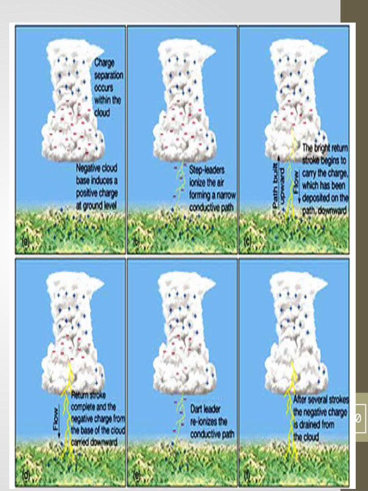
Lightning
• Electrical discharge caused by rapid movement of air with in a cumulonimbus cloud Friction between updrafts of air and of downdrafts cause the airs to lose e- forming Ions. These are (+) and (-) charged particles.
27

• • •
• • • Creates and electrical imbalance which in turn creates an invisible channel of negative charged air between the cloud and the ground
• • The channel meets the (+) charge round in close areas - return strike is upward towards the cloud - lightning
•
28

29
30

• Lightning bolts heat the air surrounding it to 30,000°C
• • Thunder - rapid expansion and contraction of air, caused by intense heat.
• • Know safety tips - Table 13.1 p 336
31

Downburst
• Violent downdraft in small areas• · Areas that are 5 km wide are called macrobursts - last 30
• minutes wind speed - 200 mph• · Areas less than 3 km wide are called microbursts - 10
• minutes or less - wind speeds 250 mph - can cause
• extensive damage but difficult to detect•
32

Microburst
33
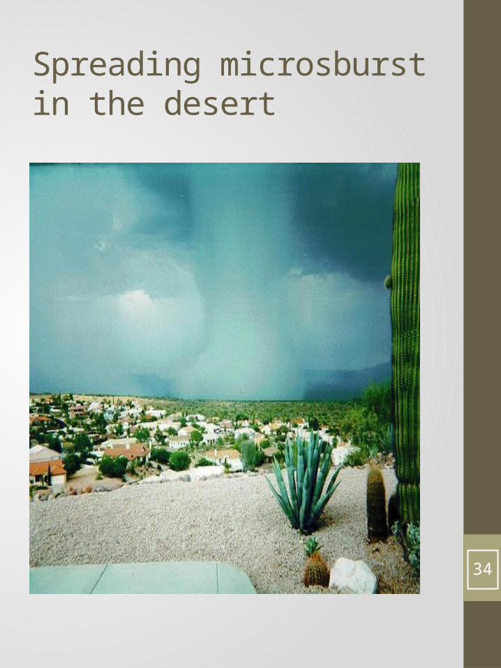
Spreading microsburst in the desert
34

Wind Shear
• When wind changes speed, direction and magnitude quickly and/or violently
•
35

36

Wind Shear Damage
37

• Hail - Precipitation that falls as ice balls - occurs interior section of the U.S. -spring
• Two Conditions for hail:• · Droplets in upper atmosphere reach temperature below
• freezing - become ice pellets• · Strong updrafts and downdrafts carry the pellets up and down with other super- cooled water droplets added on. The balls of ice fall to the ground because of the pull of gravity
38

Hail Formation
39

Hail Storm
40

Baseball Size Hail usually in Oklahoma
41
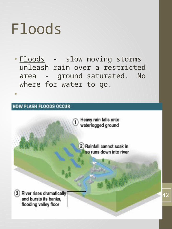
Floods
• Floods - slow moving storms unleash rain over a restricted area - ground saturated. No where for water to go.
•
42

Flash Flood from melting snow
43
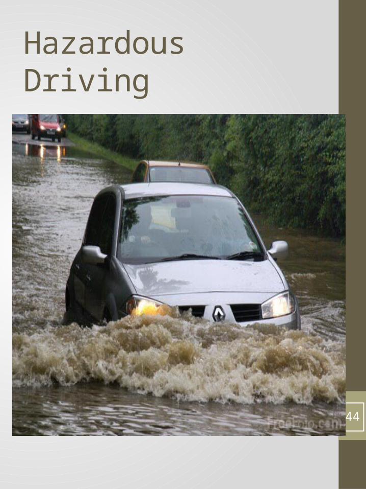
Hazardous Driving
44

Characteristics of Floods
45

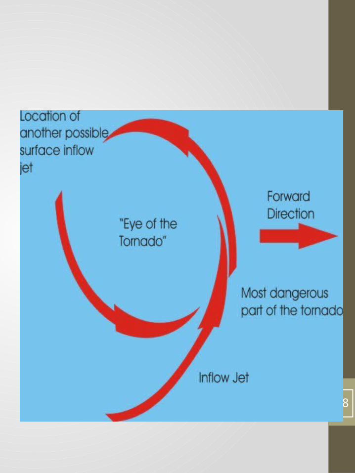
Tornados
• Violent whirling column of wind in the air - called funnel clouds -sparked by super cells. When winds’ speed and direction changes quickly with height.
• There are an average of 800 tornados nationwide per year.
• Tornadoes are made visible by debris.•
46

47
48

Damage
49
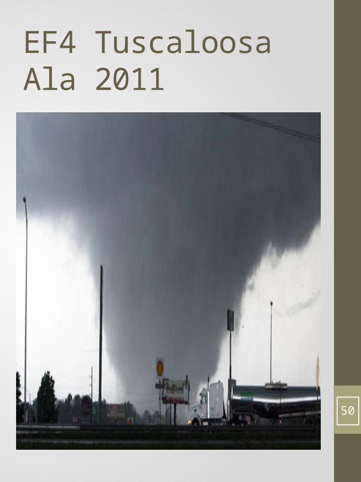
EF4 Tuscaloosa Ala 2011
50

Tuscaloosa tornado Damage 2011• Click on Link beloe]w
• http://video.search.yahoo.com/video/play;_ylt=A0S00MrywPlQhBgARHj7w8QF;_ylu=X3oDMTBvcXNvNnBqBHNlYwNzcgRzbGsDdmlkBHZ0aWQDVjEzMw--?p=tornado+damage+in+tuscaloosa+ala&vid=14e2bc9e81f5f643c29a32662c125a3b&l=00%3A13&turl=http%3A%2F%2Fts1.mm.bing.net%2Fth%3Fid%3DV.5007017859481864%26pid%3D15.1&rurl=http%3A%2F%2Fwww.youtube.com%2Fwatch%3Fv%3DTeUw-IZ7Kqk&tit=Tuscaloosa+Tornado+Damage+4-29-11&c=11&sigr=11au0jv3e&b=31&tt=b
51

EF5 Joplin Missouri 20011
52

Joplin Video Damage
53

Narrow Vortex
54

Wide Vortex
55

56

What can happen before a tornado hits an area?• 1. Hail tumbles to the ground.• 2. Erie silence, still motionless• 3. Green like sky• 4. Train sound• 5. Cloud of debris• 6. Sight of a Funnel cloud• 7. Calm behind a storm.Night time tornados are invisible so the train sound is evident
Man made warning: a long siren Check with the area you live in to see what their tornado warning system is.
57

Tornado sounds
• Click on link below• http://www.youtube.com/watch?v=2A3BYtc00I8
• Click on link below• http://video.search.yahoo.com/video/play;_ylt=A0S00MnLuflQj1kANjz7w8QF;_ylu=X3oDMTBvcXNvNnBqBHNlYwNzcgRzbGsDdmlkBHZ0aWQDVjEzMw--?p=tornado+sounds+in+a+rainstorm&vid=055ba555fc8fa60f7761b8a888ab2e85&l=&turl=http%3A%2F%2Fts2.mm.bing.net%2Fth%3Fid%3DV.4684822355181625%26pid%3D15.1&rurl=http%3A%2F%2Fwww.youtube.com%2Fwatch%3Fv%3D4tnwJe6vvrE&tit=Rain+Storm+and+the+sounds+of+a+Tornado&c=0&sigr=11af4js5n&fr=yfp-t-701&tt=b
58

Tornado Alley No other country in the world receives more tornadoes than the United States.
States in the south central area of the United States experience the greatest number of tornadoes, thus the name “Tornado Alley.”
Conditions for the violent windstorms in this region are often time ideal.
When cool, dry air from the north meets warm, moist air from the Gulf of Mexico, tornadoes are frequently the result of this meeting.• • •
59

60
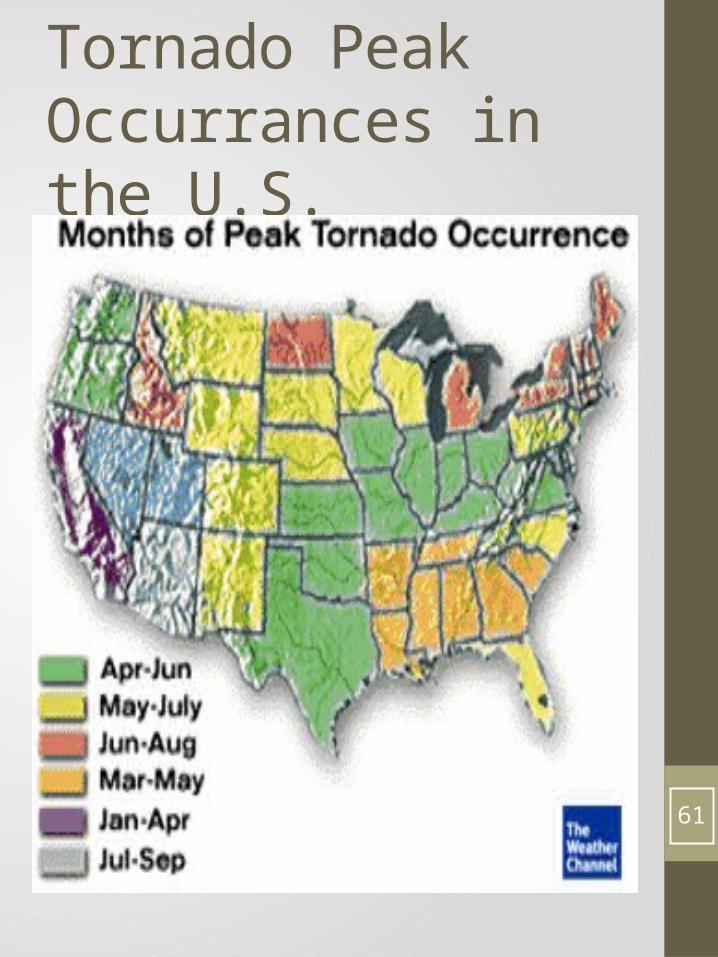
Tornado Peak Occurrances in the U.S.
61

Weather Patterns
62

63

Tornado Siren
• http://video.search.yahoo.com/video/play;_ylt=A0S00Mn0vvlQyGoA3Oj7w8QF;_ylu=X3oDMTBvcXNvNnBqBHNlYwNzcgRzbGsDdmlkBHZ0aWQDVjEzMw--?p=tornado+warning+siren&vid=4f3626062a53c0560eaeb43035ad6043&l=00%3A15&turl=http%3A%2F%2Fts3.mm.bing.net%2Fth%3Fid%3DV.4810879608488038%26pid%3D15.1&rurl=http%3A%2F%2Fwww.youtube.com%2Fwatch%3Fv%3Dnuu2iNisoQc&tit=Tornado+Siren&c=1&sigr=11atm4k29&fr=yfp-t-701&tt=b
64

Shelter
65

Fujita Scale• Tornadoes are classified into five categories, F-0 through F-5. F-0 tornadoes are the mildest. F-5 tornadoes are the most dangerous (and the rarest).
• F-0 40-72 mph, Light damage, chimney damage, tree branches broken
• F-1 73-112 mph, Moderate damage, mobile homes pushed off foundation or flipped over
• F-2 113-157 mph, Considerable damage, mobile homes demolished, trees uprooted
• F-3 158-205 mph, Severe damage, roofs and walls torn down, trains overturned, cars thrown around
• F-4 207-260 mph, Devastating damage, well-constructed walls leveled
• F-5 261-318 mph, Violent damage, homes lifted off foundation and carried considerable distances, autos thrown as far as 100 meters.
66

Water Spout
• Intense column vortex that occurs over a body of water, connected to a cumuliform cloud.
• Non super cell tornado over water.• They do not suck up water. The water seen is droplets formed by condensation,
• 2 kilometers wide. • Weaker than a tornado
67

Waterspout
• Five part life cycle• 1. Formation of a dark spot on the water surface
• 2. spiral pattern on the water surface• 3. formation of a spray ring• 4. development of the visible condensation funnel
• 5. Ultimately decay.
68

Where do they occur?
• Locations in higher latitude within the temperate zones
• Reports in Europe and the Great Lakes, Florida etc.
69

Waterspout Diagram
70

3 spouts on Lake Huron 1999
71

Tornadic water spout from a thunderstorm.They travel from land to water.
72

Tropical Cyclones
• Tropical Cyclones - large rotating low pressure system
• Season - summer and fall • Origin - sunny tropics• Energy - from the amount of energy of warm moist tropical ocean water
73

• • U.S. Hurricanes• Indian Ocean: Cyclones• West Pacific: Typhoons• • Development: water evaporates from ocean surface. Latent heat is released when air rises and H2O vapor condenses into clouds and rain falls - created a low pressure system.
•
74

Coriolis Effect and Low Pressure Center• This causes the system to turn counter clock-wise in the N.H. (Northern Hemisphere) as moving air is added it begins to rotate faster. System increases in speed and more energy is released through condensation. Air usually rises because of a disturbance in the Tropics along the ITCZ. Pressure decreases in the center.
• Surface Winds - speeds can increase and exceed 240 km/hr
•
75

Hurricane Formation
• Conditions:• 1) abundant supply of warm moist air• 2) Disturbance to lift air• 3) Air keeps rising• • Found in all oceans except the South Atlantic and Pacific Ocean west of South America. Why? Cooler bodies of H2O and ITCZ is farther north.
• • Movement - wind currents guide them• Tropics - home to subtropical high pressure systems - move west, then towards the poles on the edges of high pressure systems. Here the prevailing westerlies guide the movement - unpredictable.
76

Hurricane
77

What does a Hurricane Need?
78

90% of the deaths are from drowning
79

Weather disturbances
• Eye forms - calm center• Eye walls - have the strongest winds - 40 to 80 km wide
80

Saffir-Simpson hurricane scale Classifies hurricanes:
81

82
• Hurricanes last until they run our of energy; if they run on land, they lose energy hurricanes have: thunderstorms; tornadoes and rain.
• •
83

• Hurricane Hazards - winds that are more than 60km/hr . can be as far as 400 km from the eye; storm surges are driven by hurricane force winds that force large amounts of ocean water onto the coastal areas.
• • Northern Hemisphere - right side of the hurricane has the strongest winds. floods can occur. National Hurricane center tracks these storms; observes 36 hours in advance; gives warning - 24 hours in advance. Advises position, strength, movement.
• Hurricanes are named due to the excessive number of storms being tracked at one
• time. 84

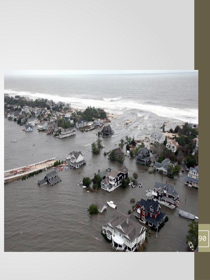
Hurricane Sandy
85

Storm Surge
86

87

Water logged soils
88

Jersey Boardwalk
89
90

Satellite picture Sandy
91

Frankenstorm?
• 1. Largest in Atlantic History• 2. Gale force winds 1040 miles wide• 3. Ocean temps 5 degrees above normal. • 4. Transitioned from a warm core hurricane onto an extra low tropical pressure system, a classic Nor easter
• 5, High pressure blocking pattern near Greenland• Major cause Global warming!
92