thursday, april 15 2020 04:00 pm - 05:00 pm cest
TRANSCRIPT

Drone Inspections: How to Manage Data for All Stakeholders InvolvedThursday, April 15 202004:00 PM - 05:00 PM CEST10:00 AM - 11:00 AM EST

DRONE INSPECTION WEBINAR SERIES—WEBINAR 5 OF 6—
PRESENTED IN PARTNERSHIP WITH MFE

PANELISTS
Zacc DukowitzContent Marketing Manager
—Flyability—
MODERATOR
Dustin WallerSenior UAS Analyst
—Occidental Petroleum—
Danny Landry VP Of Business Development
& Marketing—Premium Inspection &
Testing—

WEBINAR ENGAGEMENT
Ask questions during the webinar.
REPLAY
The recording of this webinar will be sent to you afterward.

1 5’ Introduction
2. 25’ Dustin Waller, Occidental PetroleumDrone inspections: How to manage data for all stakeholders involved—an end user’s perspective
3. 25’ Danny Landry, Premium Inspections & Testing Drone inspections: How to manage data for allstakeholders involved—an inspection serviceprovider’s perspective
4. 20’ Q&AAudience questions answered live
AGENDA

Dustin Waller Senior UAS Analyst
Drone Inspections: How to Manage Data for All Stakeholders Involved—An End User’s Perspective

Oxy UAS Program Overview
Legacy Anadarko
• 2016: Began flying (FAA Part 107)• 2016-2017: Slowly began integrating drones into
the field for special projects• 2018: Anadarko Drone Team formally created• 2018-2019: Built internal flight management
systems and data workflows• 2019: ~40 certified drone pilots & 30 drones
Legacy Oxy
• 2016: Began flying (FAA Part 107)• 2016-2018: Slowly began integrating drones into
the field for special projects• 2019: Oxy Drone Team formally created• 2019: ~20 certified drone pilots & 20 drones in the
field
2019: Oxy acquires Anadarko
Post Acquisition Oxy (2020+)
• 44 Current/Proposed Pilots• 47 Operational Drones• > 1,000 flights flown• > 44,000 acres mapped• Internal Training Program• Fully Automated Data Workflow• Internal Project and Flight Management
Systems• DroneDeploy API Integration

Project Request
Drone Team Review
Request Assigned to
Pilot
Completes Flight
RequestRequest
Approved
Process Workflow
Export Generated
Trigger
Notification Received and Flight Request Updated
Nightly Python Script
QC and Notifications
Data Available in
all ESRI Platforms
Arrives at Project
Location
Completes Pre-Flight Checklist
Flies Mission
Uploads Collected
Data to DroneDeplo
y
Processing Complete
Trigger
All Employees
Drone Team
Drone Pilot
DroneDeploy API
Office 365
Python

Flight Request Form
Key Features
• ArcGIS JS API 4.x• Feature services from Portal and FAA ArcGIS Online• Facility Name lookup using SAP service• Facility Location (lat/lon) auto populated by SAP, GIS
Facility Search, or mouse click• Automatic NOTAM info population• Automatic Flight Request Approval (based on conditions
built into form)• DroneDeploy Project/Map Template creation based on type
of flight• WMTS layer of all historical drone imagery
DroneDeploy AOI

DroneDeploy Triggers
MapPlan: Complete
• Fires once the map has completed processing• Initiates the export creation for the Orthomosaic, DTM,
and Plant Health.
Function to initiate exports
(GraphQL)
Processing Complete
Generate 3Exports
Export: Complete
• Fires once each export has been generated• Initiates the creation of the csv file in Microsoft Flow
Microsoft Flow generates csv file
(OneDrive)
Export Complete
CSV FileName:• ProjectName_MapPlanID_datetimeContains: • DownloadURL• FlightReqID• RequestorEmail• ExportType
• AssetArea• FlightType• ProjLatLng

Completing the Workflow
ArcPy
Script runs every night at 10pm performing the following steps:
• Downloads and exports processed zip files to archive folder
• Downloads all photos, panoramic images, and videos and stores in SharePoint Document Library
• Generates point features representing the downloaded media and adds attribution to each (date, facility name, type, link, flight request ID)
• Generates PDF of imagery and a direct link to Portal
• Notifies the Drone team that a new project has been completed and a quick QC of the data is performed
• Once verified, a notification email is sent to initial requestor with PDF, link to Portal, and project information
Portal for ArcGIS
• WMTS Layer coming directly from DroneDeploy• Point Feature Class containing all additional media information• Available to entire company• Operations Dashboard to manage special projects (flare inspection, power
pole, etc…)• Project specific web maps displaying contours, DTMs, vegetation analysis,
etc…
SharePoint Online
• Flight Request contains various project attribute information• DroneDeploy information like project specific web tile layer URL,
DroneDeploy project ID, direct ortho download path, etc…• Drone Data Library pulls all “Completed” projects from SharePoint Flight
Request list and displays in a searchable table that is connected to an ArcGIS JS Map. Each project has the ortho, DTM, vegetation data, Panos, single images, PDF, videos, and project information

Drone Data Library

Imagery Comparison Tool

Project Request Map

Danny LandryVP Of Business Development & Marketing
Drone Inspections: How to Manage Data for All Stakeholders Involved—An Inspection Service Provider’s Perspective

17
Drone Data Workflow
o Data Management as a Contractoro Data security is #1 priorityo Value of data
o Data Collectiono Data Delivery
18
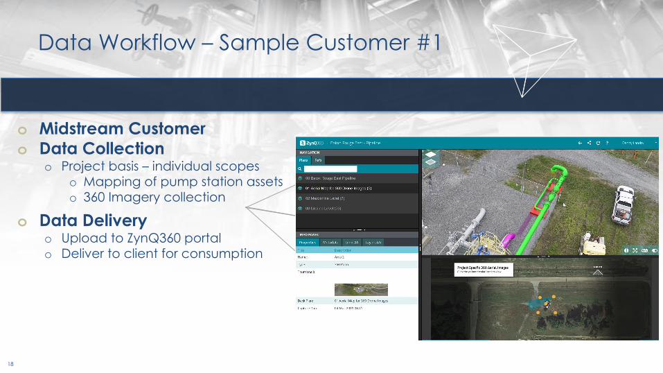
o Midstream Customero Data Collection
o Project basis – individual scopeso Mapping of pump station assetso 360 Imagery collection
o Data Deliveryo Upload to ZynQ360 portalo Deliver to client for consumption
Data Workflow – Sample Customer #1

19
o Utility Customero Data Collection
o Specific to procedure/scopeo ROW Vegetationo Comprehensiveo Storm Response
o Data naming systemo Simple but critical
o Data Deliveryo Upload to customer portalo Back up secondary copy on in-house
server
Data Workflow – Sample Customer #2

20
o Refinery Customero Data Collection
o Emergency flare outageo Focus on quick actionable data
o Data Deliveryo API inspector builds out PDF report and
provides recommendations
Data Workflow – Sample Customer #3

21
o Refinery Customer Infraredo Data Collection
o Inspector requests inspection
o Data Deliveryo Data is collected and uploaded into
customer GAVIS portal
Data Workflow – Sample Customer #4

22
o Major Capital Project - Greenfield
o Data Collectiono Mapping and 3D modeling of the siteo Customer has the goal of visualizing
change through a cloud-based portal
o Data Deliveryo Data is collected, processed and
delivered through the Pix4D Platform
Data Workflow – Sample Customer #5

23
o Refinery Customer – Post-Stormo Data Collection
o Mapping and External Close Visual Inspection of 100% of the Refinery following major hurricane
o Documentation of post storm conditions
o Data Deliveryo Data is delivered with a hybrid
approach; real time through live stream, hard drive delivery daily and through Zynq360 system
Data Workflow – Sample Customer #6

DRONE INSPECTIONS WEBINAR SERIES—PRESENTED BY FLYABILITY AND MFE—
Thursday, February 1110:00 AM EST / 4:00 PM CEST
Thursday, February 2510:00 AM EST / 4:00 PM CEST
Thursday, March 1810:00 AM EST / 4:00 PM CEST
Thursday, April 110:00 AM EST / 4:00 PM CEST
Webinar 1 of 6—The Benefits of Drone Inspections: How Inspectors Are Using Drones to Improve Safety and Save Millions
● Joe Grelewicz, Middough, Inc.● Mike Vanovermeir, MFE Rentals
Webinar 2 of 6—Drone Inspections: Insourcing vs. Outsourcing Your Drone Inspection Program
● Nick Hardwood, MISTRAS Group, Inc.● Zacc Dukowitz, Flyability
Webinar 3 of 6—Indoor Drone Inspections: Case Studies & Best Practices from the Field● Nick Hardwood, MISTRAS Group, Inc.● Zacc Dukowitz, Flyability
Webinar 4 of 6—Outdoor Drone Inspections: Case Studies & Best Practices from the Field● Courtland Penk, Osprey Integrity, Ltd. ● Zacc Dukowitz, Flyability
UPCOMING WEBINARSThursday, April 2910:00 AM EST / 4:00 PM CEST
Webinar 6 of 6—Drone Inspections: The Importance of Data Localization● Simon Kumm, InspecDrone● Geoffroy le Pivain, Flyability
LEARN MORE & REGISTER: https://www.flyability.com/events-and-webinars

MFE—NORTH AMERICAN LOCATIONS—
MFE Canada● Edmonton, AB● Toronto, ON
MFE U.S.● Benicia, CA● Huntington Beach, CA● Denver, CO● Austin, TX● Houston, TX● Baton Rouge, LA● Chicago, IL● Atlanta, GA
MFE Mexico● Boca del Rio, VC

Need drone inspection services in the U.S.?
Get in touch with Danny.
Send an email to [email protected]
● Include scope of work (as possible)● General consultations for inspection work also available● Feel free to email with questions about the presentation!
Danny LandryPremium Inspection & TestingVP Of Business Development & Marketing

Q&A
Send your follow-up questions to:Dustin Waller, Occidental Petroleum—[email protected]
Danny Landry, Premium Inspection & Testing—[email protected]
Johan Mlouka, Flyability—[email protected]
Zacc Dukowitz, Flyability—[email protected]