tidal benthic monitoring database: version 4 to support the document the tidal benthic monitoring...
TRANSCRIPT

TIDAL BENTHIC MONITORING DATABASE: Version 4.0 DATABASE DESIGN DOCUMENTATION AND DATA DICTIONARY
30 July 2010
Prepared for:
United States Environmental Protection Agency Chesapeake Bay Program
410 Severn Avenue Annapolis, Maryland 21403
Prepared By: Interstate Commission on the Potomac River Basin
51 Monroe St., PE-08 Rockville, Maryland 20850.
i
Prepared for United States Environmental Protection Agency Chesapeake Bay Program 410 Severn Avenue Annapolis, MD 21403 www.chesapeakebay.net 1-800-968-7229 By Jacqueline Johnson Interstate Commission on the Potomac River Basin To receive additional copies of the report please call or write: Chesapeake Bay Program Funds to support the document The Tidal Benthic Monitoring Database: Version 4.0; Database Design Documentation and Data Dictionary were provided by the US Environmental Protection Agency Grant CB-97339105. Disclaimer The opinion expressed are those of the authors and should not be construed as representing the U.S. Government, the US Environmental Protection Agency, the several states or the signatories or Commissioners to the Interstate Commission on the Potomac River Basin: Maryland, Pennsylvania, Virginia, West Virginia or the District of Columbia.

ii
Table of Contents Background ....................................................................................................................................................... 1 Introduction........................................................................................................................................................ 1
The Tidal Benthic Monitoring Data ................................................................................................................ 1 Relational Data Concepts.............................................................................................................................. 2 Relational Database Structure....................................................................................................................... 2
Benthic Database Structure .............................................................................................................................. 5 Primary Data Tables...................................................................................................................................... 5
TAB_EVENT .............................................................................................................................................. 5 TAB_BIOTA_SAMPLING........................................................................................................................... 6 TAB_BIOMASS.......................................................................................................................................... 7 TAB_IBI_METRICS ................................................................................................................................... 8 TAB_PHOTO_ANALYSIS.......................................................................................................................... 8 TAB_PHOTO_EVENT ............................................................................................................................... 9 TAB_SEDIMENT_ANALYSIS.................................................................................................................. 10 TAB_TAXONOMIC_COUNT ................................................................................................................... 10 TAB_WQ_DATA ...................................................................................................................................... 11
Principal Look-Up Tables ............................................................................................................................ 12 TAB_CBP_MASTER................................................................................................................................ 12 TAB_FIPS ................................................................................................................................................ 14 TAB_G_METHOD.................................................................................................................................... 16 TAB_HUCS_8.......................................................................................................................................... 18 TAB_IBI_BOTTOM_TYPE....................................................................................................................... 20 TAB_IBI_PARAMETER ........................................................................................................................... 20 TAB_IBI_SALZONE................................................................................................................................. 21 TAB_LIFE_STAGE .................................................................................................................................. 21 TAB_LL_DATUMS................................................................................................................................... 24 TAB_METHODS_BIO.............................................................................................................................. 25 TAB_METHODS_IBI................................................................................................................................ 25 TAB_METHODS_SEDIMENT ................................................................................................................. 26 TAB_METHODS_WQ.............................................................................................................................. 27 TAB_PARAMETERS_BIO....................................................................................................................... 29 TAB_PARAMETERS_SD_WQ................................................................................................................ 29 TAB_PELLETS ........................................................................................................................................ 30 TAB_PHOTO_PARAMETER................................................................................................................... 30 TAB_PHOTO_QUALIFIERS.................................................................................................................... 31 TAB_PROGRAM ..................................................................................................................................... 31 TAB_PROJECT ....................................................................................................................................... 32 TAB_SAMPLE_TYPES............................................................................................................................ 32 TAB_SAMPLING_GEAR ......................................................................................................................... 33 TAB_SAMPLING_STRATA ..................................................................................................................... 34 TAB_SEDIMENT_TYPE.......................................................................................................................... 35 TAB_SEGS_2003 .................................................................................................................................... 36 TAB_SITE_TYPE..................................................................................................................................... 37 TAB_SOURCE......................................................................................................................................... 37 TAB_TUBE_CODES................................................................................................................................ 38 TAB_VALUE_TYPE................................................................................................................................. 38
SECONDARY LOOK-UP TABLES.............................................................................................................. 39 TAB_BAY_CRUISE ................................................................................................................................. 39 TAB_PI_SPECIES_TABLE...................................................................................................................... 39
DATA LOADING PROCEDURES................................................................................................................... 41 MARYLAND AND VIRGINIA BENTHIC DATA LOADING PROTOCOL..................................................... 41
BENTHIC EVENT DATA.......................................................................................................................... 41 BENTHIC BIOTA EVENT DATA.............................................................................................................. 42
iii
BENTHIC WATER QUALITY DATA ........................................................................................................ 43 BENTHIC SEDIMENT DATA................................................................................................................... 44 BENTHIC TAXONOMIC DATA................................................................................................................ 45 BENTHIC BIOMASS DATA ..................................................................................................................... 47 BENTHIC INDEX OF BIOTIC INTEGRITY DATA ................................................................................... 48
THE ENTITY RELATIONSHIP DIAGRAM...................................................................................................... 50
Tidal Benthic Monitoring Database: Version 4.0
1
Background
In 1996, the Chesapeake Executive Counsel adopted the "Strategy for Increasing Basin-wide Public Access to Chesapeake Bay Information". This strategy calls for the Chesapeake Bay Program (CBP) partners to develop the Chesapeake Bay Information Management System (CIMS). CIMS will electronically link a variety of information sources about the Bay and tributary rivers and make this information available to anyone—from students, to scientists, to citizens groups—electronically through the Internet and World Wide Web. The information targeted by CIMS includes technical and public information, educational material, environmental indicators, policy documents and scientific data. As a result of the CIMS initiative, CBP is working to establish a system of distributed data bases. In the ideal system, a CBP database would be created and managed by the data originator, reside with the data originator, and made directly available from the data originator’s institution on an Internet server. This system has several advantages over the traditional single data repository. Primarily, the people with the most expertise and knowledge about the data, the originators, will manage the data. Additional advantages include reduced cost due to elimination of intermediate data handling at a central repository, and decreased time between collection and release of the data. The key to the success of a distributed data management system lies in the willingness of the data generators to take responsibility for the quality and maintenance for their data as well as and in their adherence to the established data standards. As part of the implementation of CIMS, the Living Resources Data Management program designed a series of relational database structures for managing various types of Chesapeake Bay related monitoring data. Once developed, these database designs are populated with the existing data. They are intended to be turned over to the data generators for long term maintenance. The advantage of this implementation scheme is that the data generators of like data types will be running databases of identical structure. The use of these identical database structures will facilitate implementing search engines and XML data exchanges between multiple sources. The design of these databases is done as a joint effort between the data generators and the CBP technical staff. Participation of the data generators in this process provides critical expertise about the data and its usage, producing a better database. The original Tidal Benthic Monitoring Data base was designed as a joint effort between CBP Data Center Staff and the monitoring program Principal Investigators in 1997 using Microsoft Access. The database was migrated in to Microsoft SQL server in July 2010. During this migration, minor modifications were made to tables and fields to accommodate SQL Server and maintain continuity where possible with the CBP Tidal Water Quality Monitoring Database. This updated document is not intended to provide a complete discussion of the concepts of a relational database. Instead, this document describes in detail the Tidal Benthic Monitoring Database's revised structural design.
Introduction The Tidal Benthic Monitoring Data
The study of tidal benthic communities in Chesapeake Bay is an ongoing process. Benthic
monitoring studies were in progress before the signing of the 1983 Chesapeake Bay Agreement. In Virginia, much of the historical research focused on documenting the condition and dynamics of benthic communities. In Maryland, a series Power Plant monitoring studies were conducted which had significant benthic components. In 1983, the Chesapeake Bay Agreement was signed laying the ground work for the current EPA Chesapeake Bay Environmental Monitoring Program. The current long-term benthic community monitoring programs are run by the states of Maryland and Virginia, have been instrumental in development of the CBP Benthic Restoration Goals and the Chesapeake Bay Index of Benthic Integrity.
Chesapeake Bay benthic monitoring programs have historically collected diverse data types using multiple data collection protocols. This trend is anticipated to continue as technology and scientific knowledge about the benthos evolves. Therefore, the final database design has to be suitable for storing data from historic studies and current monitoring programs and have the flexibility to accommodate future data forms. The data housed in the current benthic database includes species abundance and composition
Tidal Benthic Monitoring Database: Version 4.0
2
counts, biomass determinations, sediment and water quality analyses and photographic images and other multimedia material. Method codes are used to distinguish different collecting methods and gear types.
Relational Data Concepts The various benthic monitoring data are stored in a relational database structure where data are
stored in tables related to one another by several common fields. These common fields are set as primary and/or foreign keys. The creation of relationships between tables using key fields allows for the enforcement of referential integrity. Referential integrity prohibits the data manager from entering records into a “child” table containing a foreign key for which there is not an associated primary key in the “parent” table. This database structure also employs the use of auto-generated key field. An auto generated key field cannot be edited; it is a unique, sequential or random number automatically assigned to each new record added to the table. In the case of this database, auto-generated keys are assigned to unique records based on a combination of fields. The auto-generated key is then added to a child table as part of its primary key. The principle advantage of an auto-generated key is that once assigned a table can be indexed and linked on one field instead of the combination of fields used to determine a unique record. This serves to increase the efficiency of the database and decrease data recovery time.
The following chapters describe the relational database structure for the tidal benthic data including the primary data tables and the numerous lookup or secondary tables required to define in detail the codes contained in the primary tables. Primary data tables contain the bulk of the actual data stored in a data base while secondary tables store reference information. The seven primary tables in the tidal benthic database are TAB_EVENT, TAB_BIOMASS, TAB_BIOTA_SAMPLING, TAB_IBI_METRICS, TAB_PHOTO_ANALYSIS, TAB_PHOTO_EVENT, TAB_SEDIMENT_ANALYSIS, TAB_TAXONOMIC_COUNT, AND TAB_WQ_DATA. The remaining associated look-up tables in the data base contain information supports the referential integrity of the database.
Relational Database Structure
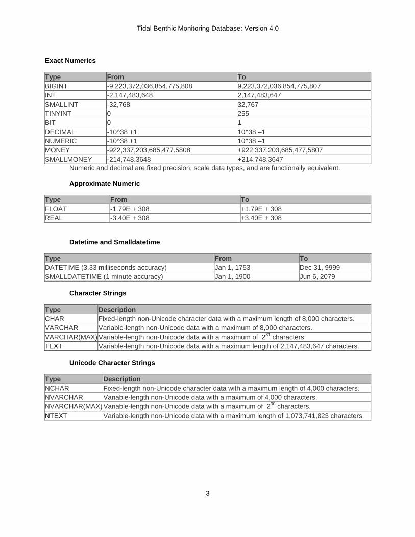
Fields in the related tables of the database have specific attributes which ensure data consistency and integrity. The various tables provided in this document contain descriptions of the database attributes. The columns in these documentation tables and their information codes are described below. FIELD - This column contains the field name in the database table as well as the designation of the field as either a primary key (PK), a foreign key (FK), a not null (NN) field, a unique field (U) or a auto-generated key field (AK). Primary, foreign and auto-generated key fields, by definition, are not null fields. However, primary and foreign keys may contain zero length value fields. Fields, which are neither primary nor foreign key fields, but which have been designated as not null or unique are those fields deemed essential to certain applications of the database. In the case of auto generated primary keys there must be a unique clustered index (CI) for the table. DESCRIPTION - This column contains a definition of the database table field. TYPE (FORMAT) - This column specifies the field type as character, number, or date/time; it also includes the format of the field and the precision of the text value where appropriate. Currently accepted data types in Microsoft SQL server 2005 used in the CBP database include the following.
Tidal Benthic Monitoring Database: Version 4.0
3
Exact Numerics Type From To BIGINT -9,223,372,036,854,775,808 9,223,372,036,854,775,807 INT -2,147,483,648 2,147,483,647 SMALLINT -32,768 32,767 TINYINT 0 255 BIT 0 1 DECIMAL -10^38 +1 10^38 –1 NUMERIC -10^38 +1 10^38 –1 MONEY -922,337,203,685,477.5808 +922,337,203,685,477,5807 SMALLMONEY -214,748.3648 +214,748.3647
Numeric and decimal are fixed precision, scale data types, and are functionally equivalent.
Approximate Numeric
Type From To FLOAT -1.79E + 308 +1.79E + 308 REAL -3.40E + 308 +3.40E + 308
Datetime and Smalldatetime
Type From To DATETIME (3.33 milliseconds accuracy) Jan 1, 1753 Dec 31, 9999 SMALLDATETIME (1 minute accuracy) Jan 1, 1900 Jun 6, 2079
Character Strings
Type Description CHAR Fixed-length non-Unicode character data with a maximum length of 8,000 characters. VARCHAR Variable-length non-Unicode data with a maximum of 8,000 characters. VARCHAR(MAX) Variable-length non-Unicode data with a maximum of 231 characters. TEXT Variable-length non-Unicode data with a maximum length of 2,147,483,647 characters.
Unicode Character Strings
Type Description NCHAR Fixed-length non-Unicode character data with a maximum length of 4,000 characters. NVARCHAR Variable-length non-Unicode data with a maximum of 4,000 characters. NVARCHAR(MAX) Variable-length non-Unicode data with a maximum of 230 characters. NTEXT Variable-length non-Unicode data with a maximum length of 1,073,741,823 characters.
Tidal Benthic Monitoring Database: Version 4.0
4
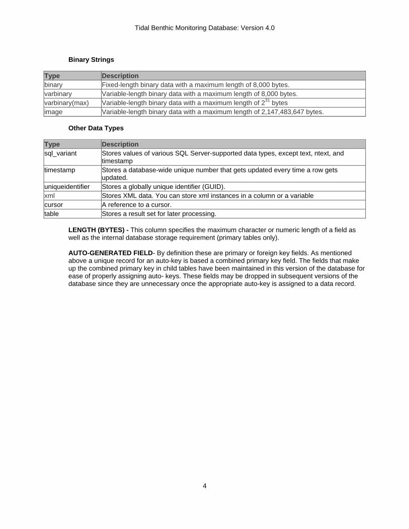
Binary Strings
Type Description binary Fixed-length binary data with a maximum length of 8,000 bytes. varbinary Variable-length binary data with a maximum length of 8,000 bytes. varbinary(max) Variable-length binary data with a maximum length of 231 bytes image Variable-length binary data with a maximum length of 2,147,483,647 bytes.
Other Data Types
Type Description sql_variant Stores values of various SQL Server-supported data types, except text, ntext, and
timestamp timestamp Stores a database-wide unique number that gets updated every time a row gets
updated. uniqueidentifier Stores a globally unique identifier (GUID). xml Stores XML data. You can store xml instances in a column or a variable cursor A reference to a cursor. table Stores a result set for later processing.
LENGTH (BYTES) - This column specifies the maximum character or numeric length of a field as well as the internal database storage requirement (primary tables only). AUTO-GENERATED FIELD- By definition these are primary or foreign key fields. As mentioned above a unique record for an auto-key is based a combined primary key field. The fields that make up the combined primary key in child tables have been maintained in this version of the database for ease of properly assigning auto- keys. These fields may be dropped in subsequent versions of the database since they are unnecessary once the appropriate auto-key is assigned to a data record.

Tidal Benthic Monitoring Database: Version 4.0
5
Benthic Database Structure Primary Data Tables
Within the current design, the primary tables are the TAB_EVENT, TAB_BIOMASS, TAB_BIOTA_SAMPLING, TAB_IBI_METRICS, TAB_PHOTO_ANALYSIS, TAB_PHOTO_EVENT, TAB_SEDIMENT_ANALYSIS, TAB_TAXONOMIC_COUNT, AND TAB_WQ_DATA.. The TAB_EVENT table contains all sampling event data for all types of sample collection events. It also contains fields specifying both the type and origin of the data. It places the occurrence of a sampling event in space and time. The BIOTA_SAMPLING_TABLE contains all sampling event data collected and analyzed for biologic content. This table was determined to be necessary due to the multiple instances where sampling events occurred and water quality, sediment and other parameters were measured but were not analyzed for biota content. The remaining table all store data of the type designated in the table name. Future version of this database may include modifications of the TAB_TAXONOMIC_COUNT and TAB_SEDIMENT_ANALYSIS to store data derived from long-core benthic samples.
TAB_EVENT
Field Name Description Data Type Length EVENT_ID (AK,PK,)
PRIMARY_ID KEY-(STATION+SAMPLE_DATE_TIME+SOURCE)
Integer
STATION (CI,NN)
SAMPLING STATION-Sampling Station identifier Varchar 15
SAMPLE_ DATE_TIME (CI,NN)
SAMPLING DATE-Date of sample collection Small Date/Time
STRATUM (FK, NN)
SAMPLING STRATUM CODE-Code describing sampling stratum
Char 6
SITE_TYPE_ CODE (FK,NN)
SAMPLING SITE TYPE-Station Sampling Site Type Code
Char 2
SOURCE (CI,FK,NN)
DATA GENERATING AGENCY-Code identifying data generator
Char 6
LATITUDE (NN)
STATION LATITUDE-Station Latitude in decimal degrees
Decimal 9,6
LONGITUDE (NN)
STATION LONGITUDE-Station Longitude in negative decimal degrees
Decimal 9,6
LL_DATUM LL_DATUM-Geographic Datum for Latitude and Longitude
char 5
FIPS (FK) FIPS CODE-Federal Information Processing System code.
Char 5
CBSEG_2003 Chesapeake Bay Program 2003 Segment Designation Char 6 HUC8 (FK) 8 DIGIT USGS HYDROLOGIC UNIT CODE Char 8 PROJECT (FK) STATE MONITORING PROJECT-Code identifying
State Monitoring Project Char 10
PROGRAM (FK) STATE MONITORING PROGRAM-Code identifying State Monitoring Program
Char 10
TOTAL_DEPTH (NN)
TOTAL STATION DEPTH-Total Station Depth in Meters Decimal 8,2
R_DATE (NN)
DATA VERSION DATE-Date denoting when data records were entered in to database
SmallDateTime
Tidal Benthic Monitoring Database: Version 4.0
6
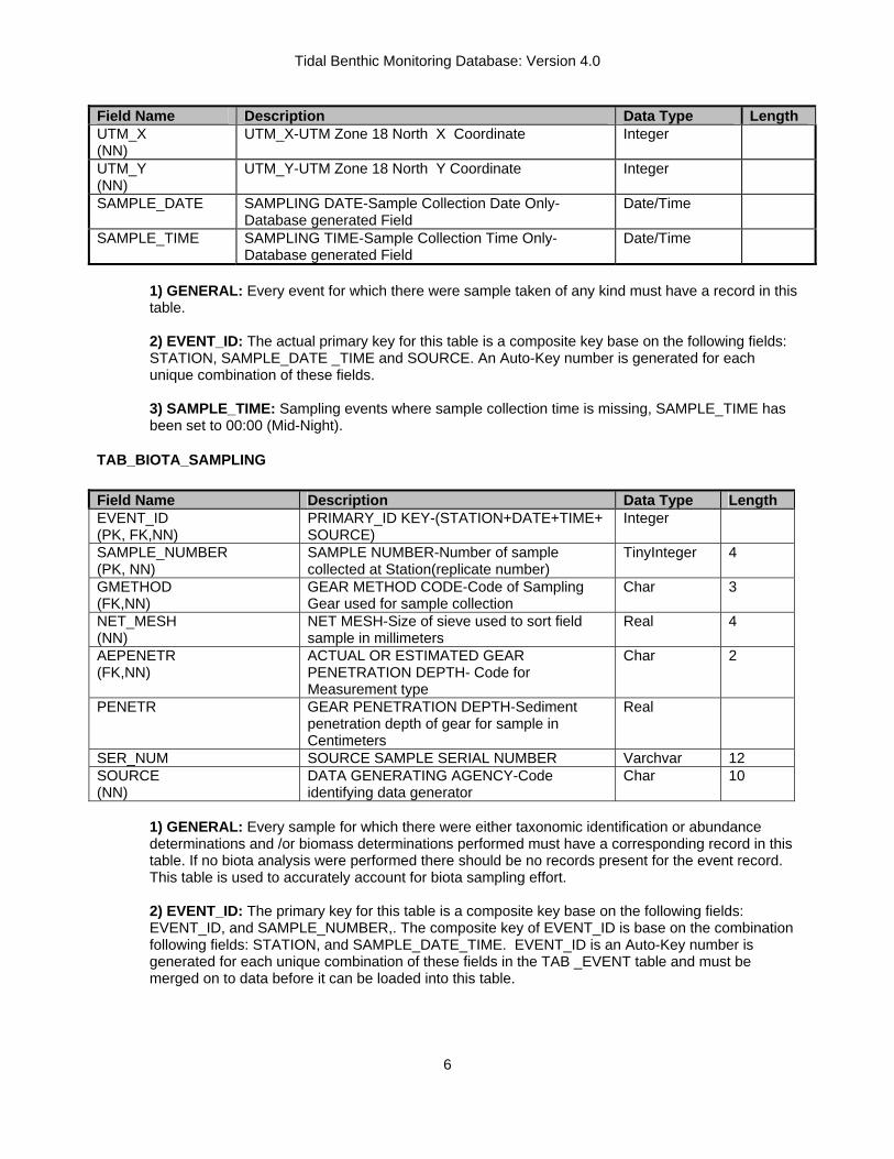
Field Name Description Data Type Length UTM_X (NN)
UTM_X-UTM Zone 18 North X Coordinate Integer
UTM_Y (NN)
UTM_Y-UTM Zone 18 North Y Coordinate Integer
SAMPLE_DATE
SAMPLING DATE-Sample Collection Date Only- Database generated Field
Date/Time
SAMPLE_TIME SAMPLING TIME-Sample Collection Time Only- Database generated Field
Date/Time
1) GENERAL: Every event for which there were sample taken of any kind must have a record in this table. 2) EVENT_ID: The actual primary key for this table is a composite key base on the following fields: STATION, SAMPLE_DATE _TIME and SOURCE. An Auto-Key number is generated for each unique combination of these fields. 3) SAMPLE_TIME: Sampling events where sample collection time is missing, SAMPLE_TIME has been set to 00:00 (Mid-Night).
TAB_BIOTA_SAMPLING Field Name Description Data Type Length EVENT_ID (PK, FK,NN)
PRIMARY_ID KEY-(STATION+DATE+TIME+ SOURCE)
Integer
SAMPLE_NUMBER (PK, NN)
SAMPLE NUMBER-Number of sample collected at Station(replicate number)
TinyInteger 4
GMETHOD (FK,NN)
GEAR METHOD CODE-Code of Sampling Gear used for sample collection
Char 3
NET_MESH (NN)
NET MESH-Size of sieve used to sort field sample in millimeters
Real 4
AEPENETR (FK,NN)
ACTUAL OR ESTIMATED GEAR PENETRATION DEPTH- Code for Measurement type
Char 2
PENETR GEAR PENETRATION DEPTH-Sediment penetration depth of gear for sample in Centimeters
Real
SER_NUM SOURCE SAMPLE SERIAL NUMBER Varchvar 12 SOURCE (NN)
DATA GENERATING AGENCY-Code identifying data generator
Char 10
1) GENERAL: Every sample for which there were either taxonomic identification or abundance determinations and /or biomass determinations performed must have a corresponding record in this table. If no biota analysis were performed there should be no records present for the event record. This table is used to accurately account for biota sampling effort.
2) EVENT_ID: The primary key for this table is a composite key base on the following fields: EVENT_ID, and SAMPLE_NUMBER,. The composite key of EVENT_ID is base on the combination following fields: STATION, and SAMPLE_DATE_TIME. EVENT_ID is an Auto-Key number is generated for each unique combination of these fields in the TAB _EVENT table and must be merged on to data before it can be loaded into this table.

Tidal Benthic Monitoring Database: Version 4.0
7
TAB_BIOMASS Field Name Description Data Type Length EVENT_ID (PK, FK,NN)
PRIMARY_ID KEY-(STATION+DATE_TIME+SOURCE)
Integer 4
SAMPLE_NUMBER (PK)
SAMPLE NUMBER-Replicate Number of sample collected at Station
Tinyint 4
BIOMASS_VALUE_TYPE (FK,NN)
ACTUAL OR ESTIMATED VALUE TYPE CODE-Code for measurement type
Char 3
TSN (PK,FK,NN)
TAXON SERIAL NUMBER- ITIS Serial Number for Species Identification
Char 7
LIFESTAGE_CODE (PK,FK,NN)
SPECIES LIFE STAGE-Additional species identifier
Char 3
REPORTING_PARAMETER (FK)
REPORTING PARAMETER-Name identifying parameter
Varchar 15
REPORTING_VALUE (NN)
REPORTED PARAMETER VALUE Real 8
REPORTING_UNITS (FK,NN)
REPORTING UNITS OF PARAMETER Varchar 15
SPEC_CODE SOURCE INHOUSE SPECIES CODE Varchar 15 SAMPLE_TYPE (FK,) SAMPLE COLLECTION TYPE CODE Char 1 BIO_METHOD CBP BIOLOGICAL METHOD CODE Char 6
1) GENERAL: This table stores information relating to measurements of benthic biomass. This database uses the Interagency Taxonomic Identification System (ITIS) Taxon Serial Numbers (TSN) for species identification within the database. For species with no TSN values temporary Chesapeake Bay TSNs are generated until a species can be submitted to ITIS for recognition. If a sample was NOT examined for species abundance and composition, there should be no records present for that sample in this table. Samples which were analyzed for biota content, but no organisms were found are denoted by the presence of a “Empty Sample Record” denoted by a TSN value of BAY0291. AN UNMATCHED RECORD QUERY SHOULD NOT BE USED TO DETERMINE SAMPLES WITH NO BIOTA PRESENT. AN UNMATCHED RECORD QUERY COMPARING THE BIOTA_TABLE AND THE BIOMASS_TABLE WILL PRODUCE A LIST OF EVENTS WHERE BIOTA CONTENT WAS EXAMINED BUT BIOMASS WAS NOT DETERMINED. This table assumes that all biomass information is derived from sediment surface grab samples. A Parameter’s SAMPLE_DEPTH is assumed to be TOTAL_DEPTH from the TAB_EVENT. (See Beginning of Primary Table section for details.) 2) EVENT_ID: The primary key for this table is a composite key base on the following fields: EVENT_ID, TSN, LIFE_STAGE_CODE and SAMPLE_NUMBER,. The composite key of EVENT_ID is base on the combination following fields: STATION, and SAMPLE_DATE_TIME. EVENT_ID is an Auto-Key number is generated for each unique combination of these fields in the TAB _EVENT table and must be merged on to data before it can be loaded into this table.

Tidal Benthic Monitoring Database: Version 4.0
8
TAB_IBI_METRICS Field Name Description Data Type Length EVENT_ID (PK,FK)
PRIMARY_ID KEY-(STATION+DATE_TIME+SOURCE)
Integer
SAMPLE_NUMBER (PK,NN)
SAMPLE NUMBER-Replicate Number of sample collected at Station
TinyInteger
IBI_PARAMETER (PK,FK)
IBI PARAMETER-Name identifying IBI Metric Varchar 15
IBI_VALUE IBI METRIC VALUE Real IBI_SCORE IBI METRIC SCORE Real IBI_SALZONE (FK,NN)
IBI SITE SALINITY ZONE CLASSIFCIATION Char 2
IBI_BOTTOM_TYPE (FK,NN)
IBI SITE BOTTOM TYPE CLASSIFICATION Char 1
IBI_METHOD (FK,NN)
INDICATES SOURCE OF IBI CALULATIONS Char 6
R_DATE (NN)
DATA VERSION DATE-Date denoting when data records were entered in to database
Small DateTime
1) GENERAL: This table stores calculated Benthic Index of Biotic Integrity (BIBI) metrics and scored values. The BIBI’s are calculated based on the published in An Estuarine Benthic Index of Biotic Integrity for Chesapeake Bay (Estuaries 20(1): 149-158 (1997)). For more details on the calculation programs included in the database see section on IBI Metric Calculation Program. 2) EVENT_ID: The primary key for this table is a composite key base on the following fields: EVENT_ID, SAMPLE NUMBER and IBI_PARAMETER. The composite key of EVENT_ID is base on the combination following fields: STATION, and SAMPLE_DATE_TIME. EVENT_ID is an Auto-Key number is generated for each unique combination of these fields in the TAB _EVENT table and must be merged on to data before it can be loaded into this table.
TAB_PHOTO_ANALYSIS Field Name Description Data Type Length EVENT_ID (PK,FK,NN)
PRIMARY_ID KEY-(STATION+DATE+TIME+ SOURCE)
Integer
SAMPLE_NUMBER (PK,NN)
SAMPLE NUMBER-Number of sample collected at Station(replicate number)
Smallinteger
PHOTO_ANALYSIS_ PARAMETER (PK,FK, NN)
PHOTO_ANALYSIS_PARAMETER-Name identifying parameter
Varchar 20
REPORTED_VALUE (NN)
REPORTED PARAMETER VALUE Real
REPORTING_UNITS REPORTING UNITS OF PARAMETER Varchar 20 PHOTO_QUALIFIER (FK) PARAMETER VALUE QUALIFIER Char 2 TYPE (NN)
TYPE-Descriptor further describing parameter and value
Varchar 100
1) GENERAL: This table stores information derived from analysis of images from the SEDIMENT PROFILE CAMERA IMAGE DATA SETS.

Tidal Benthic Monitoring Database: Version 4.0
9
2) EVENT_ID: The primary key for this table is a composite key base on the following fields: EVENT_ID, SAMPLE NUMBER and PHOTO_ANALYSIS_PARAMETER. EVENT_ID is an Auto-Key number is generated for each unique combination of these fields in the TAB _EVENT table and must be merged on to data before it can be loaded into this table.
TAB_PHOTO_EVENT Field Name Description Data Type Length EVENT_ID (PK,FK,NN)
PRIMARY_ID KEY-(STATION+DATE+TIME+ SOURCE)
Integer
SAMPLE_NUMBER (PK,FK,NN)
SAMPLE NUMBER-Number of sample collected at Station(replicate number)
Smallinteger
PHOTO_CD_NUMBER (PK,,NN)
CD IDENTIFIER-Identification number of photo CD containing image
Varchar 15
CD_IMAGE_NUMBER (PK,NN)
IMAGE DESIGNATION-Name of image on photo CD
Varchar 50
SEDIMENT_TYPE (FK,NN)
SEDIMENT TYPE-Wentworth Sediment Classification
Varchar 15
SURFACE_FAUNA SURFACE FAUNA DESCRIPTION-Characterization of any observed surface fauna
Varchar 50
TUBES (FK,NN)
TUBE COUNT-Descriptor of abundance of worm tubes observed in image
Varchar 8
PELLETS (FK,NN)
PELLET COUNT-Descriptor of abundance of worm fecal pellets observed in image
Varchar 10
COMMENTS COMMENT-General comment about image Varchar 150
1) GENERAL: This table stores pointer to the actual images and some gross characterizations of the images from the SEDIMENT PROFILE CAMERA IMAGE DATA SETS. 2) EVENT_ID: The primary key for this table is a composite key base on the following fields: EVENT_ID, SAMPLE NUMBER, PHOTO_CD_NUMBER AND CD_IMAGE_NUMBER. EVENT_ID is an Auto-Key number is generated for each unique combination of these fields in the TAB _EVENT table and must be merged on to data before it can be loaded into this table.

Tidal Benthic Monitoring Database: Version 4.0
10
TAB_SEDIMENT_ANALYSIS Field Name Description Data Type Length EVENT_ID (PK, FK,NN)
PRIMARY_ID KEY (STATION+DATE+TIME+SOURCE)
Integer
SAMPLE_NUMBER (PK,NN)
SAMPLE NUMBER-Number of sample collected at Station (replicate number)
Smallinteger
REPORTING_PARAMETER (PK,FK,NN)
REPORTING_PARAMETER-Sediment Reporting parameter
Varchar 15
REPORTED_VALUE (NN)
PARAMETER VALUE Real
REPORTING_UNITS (FK,NN)
REPORTING UNITS OF PARAMETER Varchar 15
SEDIMENT_METHOD (FK,NN)
METHOD CODE- Method code identifying field/laboratory analysis procedure
Char 6
SAMPLE_TYPE (FK,NN)
SAMPLE COLLECTION TYPE CODE Char 5
1) GENERAL: This table stores information relating to measurements of benthic sediment characterization. This table assumes that all sediment information is derived from sediment surface grab samples. A Parameter’s SAMPLE_DEPTH is assumed to be TOTAL_DEPTH from the TAB_EVENT. (See Beginning of Primary Table section for details.) If no sediment analysis was performed on a sampling station, there should be no records present for that station in this table. 2) EVENT_ID: The primary key for this table is a composite key base on the following fields: EVENT_ID, SAMPLE NUMBER and REPORTING_PARAMETER. EVENT_ID is an Auto-Key number is generated for each unique combination of these fields in the TAB _EVENT table and must be merged on to data before it can be loaded into this table.
TAB_TAXONOMIC_COUNT Field Name Description Data Type Length EVENT_ID (PK, FK,NN)
PRIMARY KEY- (STATION+DATE+TIME+SOURCE)
Integer
SAMPLE_NUMBER (PK, FK,NN)
SAMPLE NUMBER-Number of sample collected at Station (replicate number)
Smallinteger
TSN (PK, FK,NN)
TAXON SERIAL NUMBER- ITIS Serial Number for Species Identification
Char 7
LIFE_STAGE_CODE (PK, NN)
SPECIES LIFE STAGE-Additional species identifier
Char 3
REPORTING_PARAMETER (PK, FK,NN)
PARAMETER-Name identifying parameter Varchar 15
REPORTING_VALUE (NN)
PARAMETER VALUE Smallinteger 4
REPORTING_UNITS (FK,NN)
REPORTING UNITS OF PARAMETER Varchar 10
SPEC_CODE SOURCE INHOUSE SPECIES CODE Varchar 14 BIO_METHOD BIO_METHOD-Biological Enumeration
Method Char 6
SAMPLE_TYPE (FK,NN) SAMPLE COLLECTION TYPE CODE Char 1 SKIP SKIP-Denotes fragement or other items to be
excluded from taxa count Varchar 5

Tidal Benthic Monitoring Database: Version 4.0
11
1) GENERAL: This table stores information relating to measurements of benthic species abundance and composition. This database uses the Interagency Taxonomic Identification System (ITIS) Taxon Serial Numbers (TSN) for species identification within the database. For species with no TSN values temporary Chesapeake Bay TSNs are generated until a species can be submitted to ITIS for recognition. If no taxonomic analysis was performed on a sample, there should be no records present for that sample in. this table. Samples which were analyzed for biotic content but no organisms were found are denoted by the presence of a “Empty Sample Record” denoted by a TSN value of BAY0291. This table assumes that all taxonomic information is derived from sediment surface grab samples. A Parameter’s SAMPLE_DEPTH is assumed to be TOTAL_DEPTH from the TAB_EVENT. (See Beginning of Primary Table section for details.) 2) EVENT_ID: The primary key for this table is a composite key base on the following fields: EVENT_ID, SAMPLE NUMBER TSN, LIFE_STAGE, REPORTING_PARAMETER. EVENT_ID is an Auto-Key number is generated for each unique combination of these fields in the TAB _EVENT table and must be merged on to data before it can be loaded into this table.
TAB_WQ_DATA Field Name Description Data Type Length EVENT_ID (PK, FK,NN)
PRIMARY_ID KEY (STATION+DATE+TIME+SOURCE)
Integer
SAMPLE_NUMBER (PK,NN)
SAMPLE NUMBER-Number of sample collected at Station (replicate number)
Smallinteger
SAMPLE_DEPTH (PK,NN)
SAMPLE COLLECTION DEPTH Depths in METERS
Real
REPORTING_PARAMETER (PK,NN)
PARAMETER-Name identifying parameter Varchar 15
REPORTING_VALUE (NN)
PARAMETER VALUE Real 8
REPORTING_UNITS (FK,NN)
REPORTING UNITS OF PARAMETER Varchar 10
WQ_METHOD (FK,NN)
METHOD CODE- Method code identifying field/laboratory analysis procedure
Char 4
SAMPLE_TYPE (FK,NN)
SAMPLE COLLECTION TYPE CODE
Char 3
1) GENERAL: This table stores information relating to measurements of ambient water quality at sampling time. If no water quality sampling was performed on a sampling station, there should be no records present for that station in this table. 2) EVENT_ID: The primary key for this table is a composite key base on the following fields: EVENT_ID, SAMPLE NUMBER, SAMPLE_DEPTH and REPORTING_PARAMETER. EVENT_ID is an Auto-Key number is generated for each unique combination of these fields in the TAB _EVENT table and must be merged on to data before it can be loaded into this table.

Tidal Benthic Monitoring Database: Version 4.0
12
Principal Look-Up Tables
The primary tables have many fields containing codes that are described or defined in detail in related lookup tables. By creating one-to-many relationships between lookup tables and the primary data tables and enforcing referential integrity, data managers are restricted to entering only valid lookup table values into the primary data tables. Again, this provides an automatic layer of quality assurance that will improve the utility of the database for all users.
TAB_CBP_MASTER Field Name Description Data Type Length TSN_NUM TAXON SERIAL NUMBER-ITIS Serial
Number for Species Identification (defined as a numeric value)
Integer
TSN (PK,NN)
TAXON SERIAL NUMBER-ITIS Serial Number for Species Identification (defined as a fixed 7 character value with leading zeros)
Char 7
NODCCODE NATIONAL OCEANOGRAPHIC DATA CENTER TAXONOMIC CODES
Varchar 12
SYN SYNONYM FLAG-Chesapeake Bay Program flag denoting species with synonymous name/ accepted name (S= synonym, SA= synonym-accepted name)
Varchar 2
LATIN_NAME(NN) SPECIES LATIN NAME-SpeciesLatin/Scientific Name
Varchar 45
LEVEL PHYLOGENIC CLASSIFICATION-Denotes Phylogenic Level (phylum, class, order, etc)
Varchar 6
COMMON_NAME COMMON NAME-Species Common Name Varchar 40 R_DATE (NN) DATA VERSION DATE-Date denoting when
data records were entered in to database Small Date/Time
1) GENERAL: This table stores information in relating to the identification of species in the BIOMASS_TABLE and the TAXONOMIC_TABLE. The list includes listings for all types of organisms, benthic and non-benthic. This database uses the Interagency Taxonomic Identification System (ITIS) Taxon Serial Numbers (TSN) for species identification within the database. For species with no TSN values temporary Chesapeake Bay TSNs are generated until a species can be submitted to ITIS for recognition. The use of the standardized TSN codes among all Bay Program databases will allows for queries by species from multiple State and National biological databases. 2) TNS: Each species has been given its ITIS Taxonomic Serial Number (TSN). The ITIS (Interagency Taxonomic Information System) is a partnership of federal agencies working together to improve the organization of, and access to, standardized nomenclature. As part of this system a national, easily accessible database with reliable information on species names and their hierarchical classification has been established. The database is reviewed periodically to ensure high quality with valid classifications, revisions, and additions of newly described species. As part of this effort all Federal agencies have been asked to adopt the use of TSN code which assigns each recognized species a permanent number. The TSN allows a species to be tracked over time regardless of changes in name and taxonomic classification. TSN also provides a uniform key field for database development and species identification across multiple organizations. When used in conjunction with the NODC, the TSN overcomes the problem of numeric changes in the NODC code whenever species are reclassified. Temporary codes are assigned to taxa that are recognized in the scientific literature but have not been assigned an NODC Code and a TSN. The value

Tidal Benthic Monitoring Database: Version 4.0
13
bayxxxx has been assigned to all taxa without TSN. A temporary NODC code is developed for each unassigned taxon based on its known taxonomy and its species name. For example, the beginning couplets of the NODC code which reflect the known phylogeny of an unassigned taxon are combined with letters from its species name to form a temporary code. 3) NODCCODE: All species on the list have been assigned at least partial National Oceanographic Data Center (NODC) Taxon Codes (Version 8.0). The NODC Taxon Code is a hierarchical system of numerical codes used to represent the scientific names and phylogeny of organisms. The code links the Linnean system of biological nomenclature to a numerical schema that facilitates modern methods of computerized data storage and retrieval. An NODC code contains a maximum of 12 digits partitioned into 2-digit couplets. Each couplet represents one or more levels of the taxonomic hierarchy. For example, Digit Represents 1-2 Phylum 3-4 Class and/or Order 5-6 Family 7-8 Genus 9-10 Species 11-12 Subspecies One drawback of the NODC code is it changes over time to reflect current changes in taxonomic classifications and stopped being updated with Version 8.0. However, it provides data analysts with a very useful tool for sorting organisms into taxonomic groups. 4) SYN: Synonymous species are denoted in the table TAB_CBP_MSTR by a flag field named SYN. A code of S means a name is an ITIS recognized synonym and SA indicates the name is the accepted name for the taxa. Synonymous species will have identical NODC Taxon Codes. 5) TAXON_LEVEL: The phylogentic levels for all taxa in the TAB_CBP_MSTR are denoted not only by NODC_CODE but also a TAXON_LEVEL code. Taxon levels are assigned through the Linnean system of biological nomenclature as implemented in ITIS. Currently accepted TAXON_LEVELS and DESCRIPTION designations are as follows: TAXON_LEVEL DESCRIPTION CLS CLASS DIV DIVISION FAM FAMILY GEN GENUS GRP GROUP HYB HYBRED IFC INFRA-CLASS IFO INFRA-ORDER NON NON SPECIFIC LEVEL ORD ORDER PHY PHYLUM SBC SUB-CLASS SBF SUB-FAMILY SBO SUB-ORDER SBP SUB-PHYLUM SGEN SUB-GENUS SPC SUPER-CLASS SPE SPECIES SPO SUPER-ORDER SSP SUB-SPECIES TRI TRIBE VAR VARIETY
Tidal Benthic Monitoring Database: Version 4.0
14
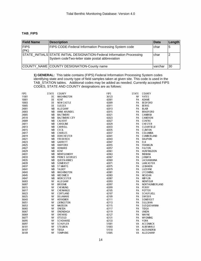
TAB_FIPS Field Name Description Data
TLength
FIPS (PK)
FIPS CODE-Federal Information Processing System code char 5
STATE_INITIALS STATE INITIAL DESIGNATION-Federal Information Processing System codeTwo-letter state postal abbreviation
char 2
COUNTY_NAME COUNTY DESIGNATION-County name varchar 30
1) GENERAL: This table contains (FIPS) Federal Information Processing System codes identifying state and county type of field samples taken at given site. This code is used in the TAB_STATION tables. Additional codes may be added as needed. Currently accepted FIPS CODES, STATE AND COUNTY designations are as follows:
FIPS STATE COUNTY 11001 DC WASHINGTON 10001 DE KENT 10003 DE NEW CASTLE 10005 DE SUSSEX 24001 MD ALLEGANY 24003 MD ANNE ARUNDEL 24005 MD BALTIMORE 24510 MD BALTIMORE CITY 24009 MD CALVERT 24011 MD CAROLINE 24013 MD CARROLL 24015 MD CECIL 24017 MD CHARLES 24019 MD DORCHESTER 24021 MD FREDERICK 24023 MD GARRETT 24025 MD HARFORD 24027 MD HOWARD 24029 MD KENT 24031 MD MONTGOMERY 24033 MD PRINCE GEORGES 24035 MD QUEEN ANNES 24039 MD SOMERSET 24037 MD ST MARYS 24041 MD TALBOT 24043 MD WASHINGTON 24045 MD WICOMICO 24047 MD WORCESTER 36003 NY ALLEGANY 36007 NY BROOME 36015 NY CHEMUNG 36017 NY CHENANGO 36023 NY CORTLAND 36025 NY DELAWARE 36043 NY HERKIMER 36051 NY LIVINGSTON 36053 NY MADISON 36065 NY ONEIDA 36067 NY ONONDAGA 36069 NY ONTARIO 36077 NY OTSEGO 36095 NY SCHOHARIE 36097 NY SCHUYLER 36101 NY STEUBEN 36107 NY TIOGA 36109 NY TOMPKINS
FIPS STATE COUNTY 36123 NY YATES 42001 PA ADAMS 42009 PA BEDFORD 42011 PA BERKS 42013 PA BLAIR 42015 PA BRADFORD 42021 PA CAMBRIA 42023 PA CAMERON 42027 PA CENTRE 42029 PA CHESTER 42033 PA CLEARFIELD 42035 PA CLINTON 42037 PA COLUMBIA 42041 PA CUMBERLAND 42043 PA DAUPHIN 42047 PA ELK 42055 PA FRANKLIN 42057 PA FULTON 42061 PA HUNTINGDON 42063 PA INDIANA 42067 PA JUNIATA 42069 PA LACKAWANNA 42071 PA LANCASTER 42075 PA LEBANON 42079 PA LUZERNE 42081 PA LYCOMING 42083 PA MCKEAN 42087 PA MIFFLIN 42093 PA MONTOUR 42097 PA NORTHUMBERLAND 42099 PA PERRY 42105 PA POTTER 42107 PA SCHUYLKILL 42109 PA SNYDER 42111 PA SOMERSET 42113 PA SULLIVAN 42115 PA SUSQUEHANNA 42117 PA TIOGA 42119 PA UNION 42127 PA WAYNE 42131 PA WYOMING 42133 PA YORK 51001 VA ACCOMACK 51003 VA ALBEMARLE 51510 VA ALEXANDRIA 51005 VA ALLEGHANY

Tidal Benthic Monitoring Database: Version 4.0
15
FIPS STATE COUNTY 51007 VA AMELIA 51009 VA AMHERST 51011 VA APPOMATTOX 51013 VA ARLINGTON 51015 VA AUGUSTA 51017 VA BATH 51019 VA BEDFORD 51023 VA BOTETOURT 51029 VA BUCKINGHAM 51031 VA CAMPBELL 51033 VA CAROLINE 51036 VA CHARLES CITY 51550 VA CHESAPEAKE CITY 51041 VA CHESTERFIELD 51043 VA CLARKE 51570 VA COLONIAL HEIGHTS 51045 VA CRAIG 51047 VA CULPEPER 51049 VA CUMBERLAND 51053 VA DINWIDDIE 51057 VA ESSEX 51059 VA FAIRFAX 51610 VA FALLS CHURCH 51061 VA FAUQUIER 51065 VA FLUVANNA 51069 VA FREDERICK 51630 VA FREDERICKSBURG 51071 VA GILES 51073 VA GLOUCESTER 51075 VA GOOCHLAND 51079 VA GREENE 51650 VA HAMPTON 51085 VA HANOVER 51087 VA HENRICO 51091 VA HIGHLAND 51093 VA ISLE OF WIGHT 51095 VA JAMES CITY 51097 VA KING AND QUEEN 51099 VA KING GEORGE 51101 VA KING WILLIAM 51103 VA LANCASTER 51107 VA LOUDOUN 51109 VA LOUISA 51680 VA LYNCHBURG 51113 VA MADISON 51115 VA MATHEWS 51119 VA MIDDLESEX 51121 VA MONTGOMERY 51125 VA NELSON 51127 VA NEW KENT 51700 VA NEWPORT NEWS 51710 VA NORFOLK 51131 VA NORTHAMPTON 51133 VA NORTHUMBERLAND 51135 VA NOTTOWAY 51137 VA ORANGE 51139 VA PAGE 51730 VA PETERSBURG 51740 VA PORTSMOUTH 51145 VA POWHATAN 51147 VA PRINCE EDWARD 51149 VA PRINCE GEORGE 51153 VA PRINCE WILLIAM 51157 VA RAPPAHANNOCK 51159 VA RICHMOND 51760 VA RICHMOND CITY 51161 VA ROANOKE 51163 VA ROCKBRIDGE 51165 VA ROCKINGHAM
FIPS STATE COUNTY 51171 VA SHENANDOAH 51177 VA SPOTSYLVANIA 51179 VA STAFFORD 51800 VA SUFFOLK 51181 VA SURRY 51810 VA VIRGINIA BEACH 51187 VA WARREN 51193 VA WESTMORELAND 51830 VA WILLIAMSBURG 51199 VA YORK 54003 WV BERKELEY 54023 WV GRANT 54027 WV HAMPSHIRE 54031 WV HARDY 54037 WV JEFFERSON 54057 WV MINERAL 54063 WV MONROE 54065 WV MORGAN 54071 WV PENDLETON
Tidal Benthic Monitoring Database: Version 4.0
16
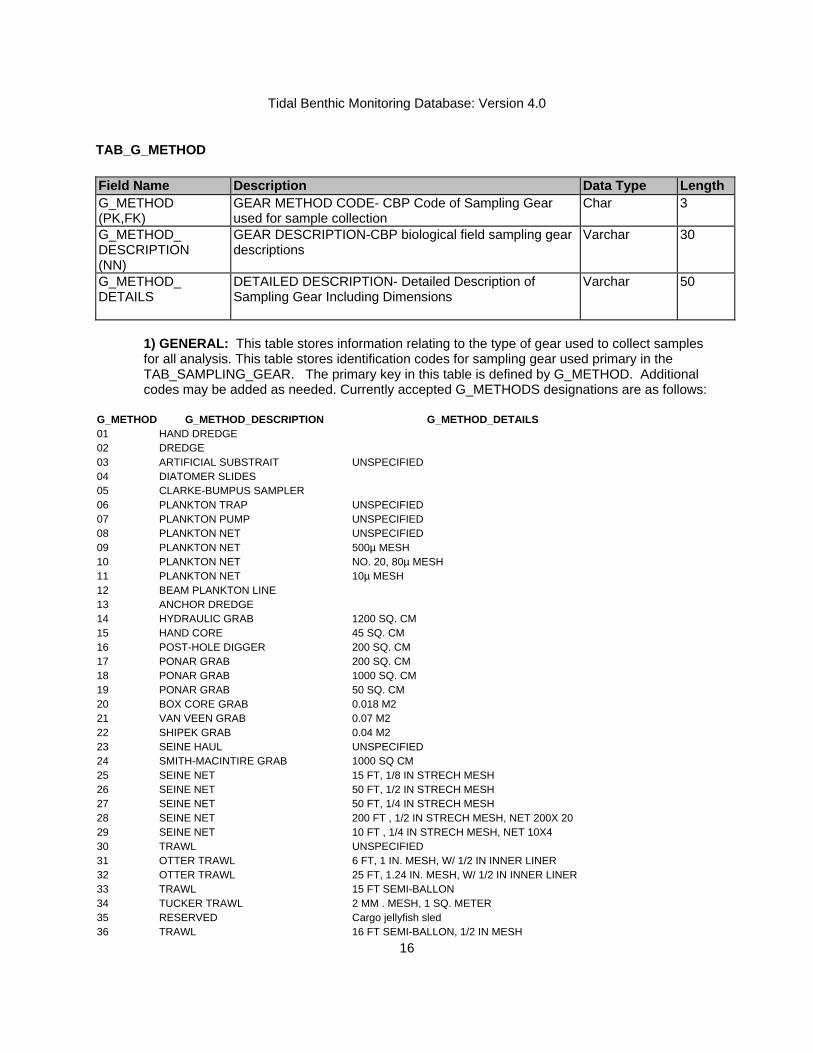
TAB_G_METHOD Field Name Description Data Type Length G_METHOD (PK,FK)
GEAR METHOD CODE- CBP Code of Sampling Gear used for sample collection
Char 3
G_METHOD_ DESCRIPTION (NN)
GEAR DESCRIPTION-CBP biological field sampling gear descriptions
Varchar 30
G_METHOD_ DETAILS
DETAILED DESCRIPTION- Detailed Description of Sampling Gear Including Dimensions
Varchar 50
1) GENERAL: This table stores information relating to the type of gear used to collect samples for all analysis. This table stores identification codes for sampling gear used primary in the TAB_SAMPLING_GEAR. The primary key in this table is defined by G_METHOD. Additional codes may be added as needed. Currently accepted G_METHODS designations are as follows:
G_METHOD G_METHOD_DESCRIPTION G_METHOD_DETAILS 01 HAND DREDGE 02 DREDGE 03 ARTIFICIAL SUBSTRAIT UNSPECIFIED 04 DIATOMER SLIDES 05 CLARKE-BUMPUS SAMPLER 06 PLANKTON TRAP UNSPECIFIED 07 PLANKTON PUMP UNSPECIFIED 08 PLANKTON NET UNSPECIFIED 09 PLANKTON NET 500µ MESH 10 PLANKTON NET NO. 20, 80µ MESH 11 PLANKTON NET 10µ MESH 12 BEAM PLANKTON LINE 13 ANCHOR DREDGE 14 HYDRAULIC GRAB 1200 SQ. CM 15 HAND CORE 45 SQ. CM 16 POST-HOLE DIGGER 200 SQ. CM 17 PONAR GRAB 200 SQ. CM 18 PONAR GRAB 1000 SQ. CM 19 PONAR GRAB 50 SQ. CM 20 BOX CORE GRAB 0.018 M2 21 VAN VEEN GRAB 0.07 M2 22 SHIPEK GRAB 0.04 M2 23 SEINE HAUL UNSPECIFIED 24 SMITH-MACINTIRE GRAB 1000 SQ CM 25 SEINE NET 15 FT, 1/8 IN STRECH MESH 26 SEINE NET 50 FT, 1/2 IN STRECH MESH 27 SEINE NET 50 FT, 1/4 IN STRECH MESH 28 SEINE NET 200 FT , 1/2 IN STRECH MESH, NET 200X 20 29 SEINE NET 10 FT , 1/4 IN STRECH MESH, NET 10X4 30 TRAWL UNSPECIFIED 31 OTTER TRAWL 6 FT, 1 IN. MESH, W/ 1/2 IN INNER LINER 32 OTTER TRAWL 25 FT, 1.24 IN. MESH, W/ 1/2 IN INNER LINER 33 TRAWL 15 FT SEMI-BALLON 34 TUCKER TRAWL 2 MM . MESH, 1 SQ. METER 35 RESERVED Cargo jellyfish sled 36 TRAWL 16 FT SEMI-BALLON, 1/2 IN MESH

Tidal Benthic Monitoring Database: Version 4.0
17
G_METHOD G_METHOD_DESCRIPTION G_METHOD_DETAILS 37 OTTER TRAWL 10 FT, 1/4 IN. MESH, W/500 µ IN INNER LINER 38 MID-WATER TRAWL 5 FT, 1/4 IN. MESH, W/500 µ IN INNER LINER 39 RESERVED 40 TRAP NET 3 x 6 FT, 1/2 IN MESH, 50 FT LEAD 41 ELECTROSHOCKER 42 ECKMAN CAGE 43 CAGE 44 CATFISH TRAP 45 CRAYFISH TRAP 46 CRAB TRAP 47 ANIMAL TRAP 48 HOOK AND LINE FISHING 49 DIP NET 50 DIVER 51 DIAPHRAGM PUMP 52 CENTRIFUGAL PUMP 53 RESERVED 54 POUND NET 55 EPIFAUNA PANELS 56 PONAR GRAB UNSPECIFIED 57 D-FRAME NET 500 MICRON MESH, 12 INCH DIAMETER 58 RETANGULAR DIP NET 0.5 METER BY 0.5 METERS 59 HAND PICK 60 ENDICO CURRENT METER 61 BRAINCON CURRENT METER 62 SEDIMENT TRAP ARRAY 6- 3"X30" CUPS {BOYTON-CBL} 63 SEINE NET 50 FT, 1/4 IN MESH, NET 100X4 FT 64 BONGO NET UNSPECIFIED 65 PURSE SEINE 66 FYKE AND HOOP NETS 67 POTS 68 BOX TRAP 69 PUSH NET 70 GREAT LAKE SHOAL 1-2 INCHES 71 GREAT LAKE SHOAL 2-4 INCHES 72 GREAT LAKE SHOAL 4-7 INCHES 73 GREAT LAKE SHOAL 7-14 INCHES 74 BEAM TRAWL 75 BONGO NET 202 µ, 20 CM OPENING, 0.76 M LENGTH 76 BONGO NET 202 µ, 50 CM OPENING, 4 M LENGTH 77 RESERVED 78 SLAT TRAP 79 RESERVED 80 GIL NETS 81 USNOL SPADE CORE 0.06 M2 SPADE BOX CORE 82 PONAR GRAB-ODU 83 DOUBLE PONAR GRAB-VA DEQ 50 SQ CM 84 RESERVED 85 MID-WATER TRAWL 86 KICK NET 23 CM x 46 CM, MESH OPEN SIZE 0.8MM BY 0.9 MM 87 KICK NET UNSPECIFIED 88 RESERVED 89 D-FRAME NET UNSPECIFIED 90 HESTER DENDY MULTIPLATE SAMPL 91 SURBER SAMPLER 92 KICK SEINE

Tidal Benthic Monitoring Database: Version 4.0
18
G_METHOD G_METHOD_DESCRIPTION G_METHOD_DETAILS 93 D-FRAME NET 600 MICRON, 12 INCH DIAMETER 94 KICK NET 600 MICRON, 1 SQUARE METER KICK SCREEN 96 HYDROLIC VAN VEEN GRAB 0.1 SQUARE METERS 97 YOUNG MODIFIED VAN VEEN GRAB 0.04 SQ M 98 PETITE PONAR GRAB 25 SQUARE CM 99 SMITH-MACINTIRE GRAB 0.3 SQUARE METER 100 SMITH-MACINTIRE GRAB 0.2 SQUARE METER
TAB_HUCS_8 Field Name Description Data Type Length HUC_8 (PK,NN)
8 DIGIT HUC CODE- Sub-Basin unit associated with the first eight digits of HUC_12
Char 8
HUC_6 (NN)
6 DIGIT HUC CODE- Basin associated with the first six digits of HUC_12
Char 6
HUC_4 (NN)
4 DIGIT HUC CODE- Sub-region associated with the first four digits of HUC_12
Char 4
HUC_2 (NN)
2 DIGIT HUC CODE-Region two digits of HUC_12 Char 8
REGION_ DESCRIPTION (NN)
REGION_DESCRIPTION-Detailed Description of Region described by first two digits of HUC code
Varchar 80
SUBREGION_ DESCRIPTION (NN)
SUBREGION_DESCRIPTION-Detailed Description of Region described by first four digits of HUC code
Varchar 80
ACCOUNTING_ DESCRIPTION (NN)
ACCOUNTING_DESCRIPTION- Detailed Description of Region described by first six digits of HUC code
Varchar 80
CATALOGING_ DESCRIPTION (NN)
CATALOGING_DESCRIPTION_ Detailed Description of Region described by first eight digits of HUC code
Varchar 80
1) GENERAL: The TAB_HUCS8 TABLE contains 8-digit USGS hydrologic unit codes and descriptions. The HUC8 code is the 8-digit USGS hydrologic unit code in which the station is located. The list that follows contains only the HUC and the associated cataloging unit description. Additional lookup tables related to this table may or may not be included in the final database design. These tables contain specific information related to the REGION, SUBREGION, ACCOUNTING_UNIT, and CATALOGING_UNIT fields. The currently accepted 8- digit HUC and CATALOGING_DESCRIPTIONS are as follows:
HUC_8 CATALOGING_UNIT_DESCRIPTION
02040303 CHINCOTEAGUE 02040304 EASTERN LOWER DELMARVA 02050101 UPPER SUSQUEHANNA 02050102 CHENANGO 02050103 OWEGO-WAPPASENING 02050104 TIOGA 02050105 CHEMUNG 02050106 UPPER SUSQUEHANNA-TUNKHANNOCK 02050107 UPPER SUSQUEHANNA-LACKAWANNA 02050201 UPPER WEST BRANCH SUSQUEHANNA 02050202 SINNEMAHONING
HUC_8 CATALOGING_UNIT_DESCRIPTION 02050203 MIDDLE WEST BRANCH SUSQUEHANNA 02050204 BALD EAGLE 02050205 PINE 02050206 LOWER WEST BRANCH SUSQUEHANNA 02050301 LOWER SUSQUEHANNA-PENNS 02050302 UPPER JUNIATA 02050303 RAYSTOWN 02050304 LOWER JUNIATA 02050305 LOWER SUSQUEHANNA-SWATARA 02050306 LOWER SUSQUEHANNA 02060001 UPPER CHESAPEAKE BAY

Tidal Benthic Monitoring Database: Version 4.0
19
HUC_8 CATALOGING_UNIT_DESCRIPTION 02060002 CHESTER-SASSAFRAS 02060003 GUNPOWDER-PATAPSCO 02060004 SEVERN 02060005 CHOPTANK 02060006 PATUXENT 02060007 BLACKWATER-WICOMICO 02060008 NANTICOKE 02060009 POCOMOKE 02060010 CHINCOTEAQUE 02070001 SOUTH BRANCH POTOMAC 02070002 NORTH BRANCH POTOMAC 02070003 CACAPON-TOWN 02070004 CONOCOCHEAGUE-OPEQUON 02070005 SOUTH FORK SHENANDOAH 02070006 NORTH FORK SHENANDOAH 02070007 SHENANDOAH 02070008 MIDDLE POTOMAC-CATOCTIN 02070009 MONOCACY 02070010 MIDDLE POTOMAC-ANACOSTIA-OCCOQUAN02070011 LOWER POTOMAC 02080101 LOWER CHESAPEAKE BAY 02080102 GREAT WICOMICO-PIANKATANK 02080103 RAPIDAN-UPPER RAPPAHANNOCK 02080104 LOWER RAPPAHANNOCK 02080105 MATTAPONI 02080106 PAMUNKEY 02080107 YORK 02080108 LYNNHAVEN-POQUOSON 02080109 WESTERN LOWER DELMARVA 02080110 EASTERN LOWER DELMARVA 02080201 UPPER JAMES 02080202 MAURY 02080203 MIDDLE JAMES-BUFFALO 02080204 RIVANNA 02080205 MIDDLE JAMES-WILLIS 02080206 LOWER JAMES 02080207 APPOMATTOX 02080208 HAMPTON ROADS 03010205 ALBEMARLE

Tidal Benthic Monitoring Database: Version 4.0
20
TAB_IBI_BOTTOM_TYPE Field Name Description Data Type Length IBI_BOTTOM_TYPE (PK,NN)
INDEX OF BIOTIC INTEGRETY BOTTOM TYPE
Char 1
IBI_BOTTOM_TYPE_ DESCRIPTION (NN)
BOTTOM TYPE DESCRIPTION Varchar 10
1) GENERAL: This table stores information identifying bottom type classifications used in the calculation of BIBI metric values. Bottom type is based on the sand to clay percentages observed in the sediment analysis from each site. The IBI_BOTTOM_TYPE codes used to classify site types as follows:
IBI_BOTTOM_TYPE IBI_BOTTOM_TYPE_DESCRIPTION
M MUD S SAND
TAB_IBI_PARAMETER Field Name Description Data Type Length IBI_PARAMETER (PK,NN)
INDEX OF BIOTIC INTEGRETY METRIC Varchar 15
IBI_PARAMETER_ DESCRIPTION (NN)
METRIC DESCRIPTION Varchar 50
1) GENERAL: This table stores information identifying BIBI metric values. Metrics are based on species abundance, biomass data from the TAB_BIOMASS and the TAB_TAXONOMIC_COUNT. IBI_PARAMETER- The current BIBI metrics calculated are as follows:
IBI_PARAMETER IBI_PARAMETER _DESCRIPTION GRAND_SCORE FIXED STATION REPLICATE AVERAGED TOTAL BENTHIC RESTORATION GOAL SCORE PCT_BIO_DP05 PERCENT TOTAL BIOMASS FOUNDGREATER THAN 5 CM BELOW SEDIMENT WATER INTERFACE PCT_CARN_OMN PERCENT CARNIVORES AND OMNIVORES PCT_DEPO PERCENT DEEP DEPOSIT FEEDERS PCT_PI_ABUND PERCENT POLLUTION INDICATIVE SPECIES ABUNDANCE PCT_PI_BIO PERCENT POLLUTION INDICATIVE SPECIES BIOMASS PCT_PI_F_ABUND PERCENT POLLUTION INDICATIVE SPECIES ABUNDANCE-FRE IBI_PARAMETER IBI_PARAMETER _DESCRIPTION PCT_PI_F_BIO PERCENT POLLUTION INDICATIVE SPECIES BIOMASS-FRESH PCT_PI_O_ABUND PERCENT POLLUTION INDICATIVE SPECIES ABUNDANCE-OLI PCT_PI_O_BIO PERCENT POLLUTION INDICATIVE SPECIES BIOMASS-OLIGO PCT_PS_ABUND PERCENT POLLUTION SENSITIVE SPECIES ABUNDANCE PCT_PS_BIO PERCENT POLLUTION SENSITIVE SPECIES BIOMASS PCT_PS_O_ABUND PERCENT POLLUTION SENSITIVE SPECIES ABUNDANCE-OLIG PCT_PS_O_BIO PERCENT POLLUTION SENSITIVE SPECIES BIOMASS-OLIGOH PCT_TANYPODINI PERCENT TANYPODINAE TO CHIRONOMIDAE SW SHANNON-WEINER SPECIES DIVERSITY INDEX TOLARANCE POLLUTION TOLARACE INDEX TOT_ABUND TOTAL SPECIES ABUNDANCE (NUMBER PER METER SQUARED) TOT_BIOMASS TOTAL SPECIES BIOMASS IN (GRAMS PER METER SQUARED) TOT_TXA_DP05 SPECIES ABUNDANCE FOUND GREATER THAN 5 CM BELOW SEDIMENT WATER INTERFACE TOTAL_SCORE TOTAL BENTHIC RESTORATION GOAL SCORE FOR SAMPLE

Tidal Benthic Monitoring Database: Version 4.0
21
TAB_IBI_SALZONE Field Name Description Data Type Length IBI_SALZONE (PK)
INDEX OF BIOTIC INTEGRETY SALINITY ZONE
Char 2
IBI_SALZONE_ DESCRIPTION (NN)
DESCRIPTION OF SALINITY ZONE Varchar 25
RANGE (NN)
SALINITY RANGE IN PSU Varchar 20
1) GENERAL: This table stores information identifying salinity classifications used in the calculation of BIBI metric values. Salinity zone is based on the observed salinity in the water quality data from each site.
IBI_SALZONE- The IBI_SALZONE codes used to classify site types as follows: IBI_SALZONE DESCRIPTION RANGE HM HIGH MESOHALINE =>12 TO 18 PPT LM LOW MESOHALINE =>5.0 TO 12 PPT O OLIGOHALINE =>0.5 TO 5.0 PPT P POLYHALINE =>18 PPT TF TIDAL FRESH <0.5 PPT
TAB_LIFE_STAGE Field Name Description Data Type Length LIFE_STAGE (PK,FK)
LIFE STAGE CODE- Chesapeake Bay Program Life Stage Code
Char 3
LIFE_STATE_ DESCRIPTION (NN)
DESCRIPTION-Detailed Life Stage code Description Carchar 50
1) GENERAL: This table stores information in relating to the identification of species life stages in the TAB_TAXONOMIC_COUNT table. The currently accepted LIFE_STAGE values and DESCRIPTIONS are as follows:
LIFE_STAGE_ CODE
LIFE_STAGE_ DESCRIPTION
0 EGG 1 YOLK SAC 2 FIN FOLD 3 POST FIN FOLD 4 YEAR CLASS O 5 YEAR CLASS 1 OR OLDER 6 JUVENILES AND ADULTS 7 LARVAE AND JUVENILES AND ADULTS 8 LARVAE AND JUVENILES 9 NAUPLII AND PERITRICHS 10 NAUPLII OR COPEPODITE 11 NAUPLII 12 COPEPODITE
LIFE_STAGE_ CODE
LIFE_STAGE_ DESCRIPTION
13 ORTHONAUPLII STAGE 1-3 14 METANAUPLII STAGE 4-6 15 COPEPODITE STAGE 1-3 16 COPEPODITE STAGE 4-6 17 CYPRIS LARVAE 18 RESERVED FOR FUTURE USE 19 COPEPOD EGG 20 NYMPH 21 PUPAE 22 PHARATE 23 INSTAR 24 NAIAD 25 HATCHERTY MARKED ORGANISM

Tidal Benthic Monitoring Database: Version 4.0
22
LIFE_STAGE_ CODE
LIFE_STAGE_ DESCRIPTION
26 YEAR CLASS 2 OR OLDER
27 AGE 0 MDDNR HATCHERTY MARKED ORGANISM
28 AGE 1 MDDNR HATCHERTY MARKED ORGANISM
29 AGE 2 OR GREATER MDDNR HATCHERTY MARKED ORGANISM
30 PREZOEA 31 ZOEA 32 METAZOEA 33 MEGALOPS 34 MALE,UNSPECIFIED AGE 35 FEMALE, ADULT 36 FEMALE,JUVENILE 37 MDDNR HATCHERTY MARKED ORGANISM 38 MALE, AGE CLASS 0 39 MALE, AGE CLASS 1 40 NAUPLII STAGE 1 41 NAUPLII STAGE 2 42 NAUPLII STAGE 3 43 NAUPLII STAGE 4 44 NAUPLII STAGE 5 45 NAUPLII STAGE 6 46 COPEPODITE STAGE 1 47 COPEPODITE STAGE 2 48 COPEPODITE STAGE 3 49 COPEPODITE STAGE 4 50 COPEPODITE STAGE 5 51 COPEPODITE STAGE 6 52 SPECIES A 53 SPECIES B 54 SPECIES C 55 SPECIES D 56 SPECIES E 57 SPECIES F 58 SPECIES A-FULL 59 SPECIES A-EMPTY 60 SPECIES B-FULL 61 SPECIES B-EMPTY 62 SPECIES C-FULL 63 SPECIES C-EMPTY 64 EMBRYO 65 NEONITES 66 MALE, AGE CLASS 2 67 FEMALE, IMMATURE AGE CLASS 0 68 FEMALE, IMMATURE AGE CLASS 1 69 FEMALE, MATURE AGE CLASS 1 70 FEMALE, MATURE AGE CLASS 2 71 FEMALE, MATURE AGE CLASS 0 72 FEMALE, IMMATURE AGE CLASS 2 73 SALPS
LIFE_STAGE_ CODE
LIFE_STAGE_ DESCRIPTION
74 MALE, ADULT 75 FEMALE,UNSPECIFIED AGE 76 GROUP 77 WITH CAP. SETAE 78 WITHOUT CAP. SETAE 79 SPP. 80 MOLTED 81 UNMOLTED 82 LARGE 83 LARGE-FULL 84 LARGE-EMPTY 85 FULL 86 EMPTY 87 MEDIUM 88 SMALL 89 NOT SPECIFIED 90 EGG- NOT VIABLE 91 SUBADULT 92 POST LARVAL 93 JUVENILE
94 TAXON WITH COUNT STORED AS VOLUME IN MILLILITERS
95 MATURE 96 IMMATURE 97 LARVAE 98 ADULT 99 NOT APPLICABLE 100 20:49UM LENGTH <20UM WIDTH 101 20:49UM LENGTH 102 20:49UM LENGTH 50:99UM WIDTH 103 20:49UM LENGTH 20:49UM WIDTH CUP 104 20:49UM LENGTH 20:49UM WIDTH CONE 105 20:49UM LENGTH 20:49UM WIDTH 106 20:49UM LENGTH >20UM WIDTH 107 >200UM LENGTH 108 20:49UM LENGTH <20UM WIDTH CONE 109 50:99UM LENGTH <20UM WIDTH 110 100:199UM LENGTH >20UM WIDTH 111 >20UM WIDTH 112 <20UM LENGTH 113 <20UM LENGTH <20UM WIDTH CUP 114 <20UM LENGTH <20UM WIDTH CONE 115 <20UM LENGTH <20UM WIDTH 116 <20UM LENGTH CONE 117 20:49UM LENGTH <20UM WIDTH CUP 118 50:99UM LENGTH EMPTY
119 SPECIES C 100:199UM LENGTH 100:199UM WIDTH
120 SPECIES B 50:99UM LENGTH 50:99UM WIDTH
121 SPECIES B 50:99UM LENGTH 20:49UM

Tidal Benthic Monitoring Database: Version 4.0
23
LIFE_STAGE_ CODE
LIFE_STAGE_ DESCRIPTION WIDTH
122 PARVULA GRP FULL 123 PARVULA GRP 124 20:49UM LENGTH FULL 125 BEROIDEA GRP
126 SPECIES C 100:199UM LENGTH 20:49UM WIDTH
127 50:99UM LENGTH 128 50:99UM LENGTH 50:99UM WIDTH CUP 129 50:99UM LENGTH 50:99UM WIDTH CONE 130 50:99UM LENGTH 20:49UM WIDTH CUP 131 50:99UM LENGTH 20:49UM WIDTH CONE 132 50:99UM LENGTH >20UM WIDTH 133 <20UM LENGTH 100:199UM WIDTH 134 <20UM LENGTH 100:199UM WIDTH CONE 135 <20UM LENGTH 100:199UM WIDTH CUP 136 <20UM LENGTH 20:49UM WIDTH 137 <20UM LENGTH 20:49UM WIDTH CONE 138 <20UM LENGTH 20:49UM WIDTH CUP 139 <20UM LENGTH 50:99UM WIDTH 140 <20UM LENGTH 50:99UM WIDTH CONE 141 <20UM LENGTH 50:99UM WIDTH CUP 142 <20UM LENGTH CUP 143 <20UM LENGTH EMPTY 144 <20UM LENGTH FULL 145 <20UM WIDTH 146 <20UM WIDTH EMPTY 147 <20UM WIDTH FULL 148 >200UM 149 >200UM EMPTY 150 >200UM FULL 151 >200UM LENGTH <20UM WIDTH 152 >200UM LENGTH <20UM WIDTH EMPTY 153 >200UM LENGTH <20UM WIDTH FULL 154 >200UM LENGTH >20UM WIDTH 155 >200UM LENGTH >20UM WIDTH EMPTY 156 >200UM LENGTH >20UM WIDTH FULL 157 >200UM LENGTH EMPTY 158 >200UM LENGTH FULL 159 >20UM WIDTH EMPTY 160 >20UM WIDTH FULL 161 100:199UM LENGTH <20UM WIDTH 162 100:199UM LENGTH <20UM WIDTH CONE 163 100:199UM LENGTH <20UM WIDTH CUP 164 100:199UM LENGTH <20UM WIDTH EMPTY 165 100:199UM LENGTH <20UM WIDTH FULL 166 100:199UM LENGTH >20UM WIDTH EMPTY 167 100:199UM LENGTH >20UM WIDTH FULL
168 100:199UM LENGTH 100:199UM WIDTH CONE
LIFE_STAGE_ CODE
LIFE_STAGE_ DESCRIPTION
169 100:199UM LENGTH 100:199UM WIDTH CUP 170 100:199UM LENGTH 20:49UM WIDTH CONE 171 100:199UM LENGTH 20:49UM WIDTH CUP 172 100:199UM LENGTH 50:99UM WIDTH CONE 173 100:199UM LENGTH 50:99UM WIDTH CUP 174 100:199UM LENGTH CONE 175 100:199UM LENGTH CUP 176 100:199UM LENGTH 177 100:199UM LENGTH EMPTY 178 100:199UM LENGTH FULL 179 20:49UM LENGTH <20UM WIDTH EMPTY 180 20:49UM LENGTH <20UM WIDTH FULL 181 20:49UM LENGTH >20UM WIDTH EMPTY 182 20:49UM LENGTH >20UM WIDTH FULL 183 20:49UM LENGTH 100:199UM WIDTH 184 20:49UM LENGTH 100:199UM WIDTH CONE 185 20:49UM LENGTH 100:199UM WIDTH CUP 186 20:49UM LENGTH 50:99UM WIDTH CONE 187 20:49UM LENGTH 50:99UM WITDH CUP 188 20:49UM LENGTH CONE 189 20:49UM LENGTH CUP 190 20:49UM LENGTH EMPTY 191 RESERVED FOR FUTURE USE 192 50:99UM LENGTH <20UM WIDTH CONE 193 50:99UM LENGTH <20UM WIDTH CUP 194 50:99UM LENGTH <20UM WIDTH EMPTY 195 50:99UM LENGTH <20UM WIDTH FULL 196 50:99UM LENGTH >20UM WIDTH EMPTY 197 50:99UM LENGTH >20UM WIDTH FULL 198 50:99UM LENGTH 100:199UM WIDTH CONE 199 50:99UM LENGTH 100:199UM WIDTH CUP 200 50:99UM LENGTH CONE 201 50:99UM LENGTH CUP 202 RESERVED FOR FUTURE USE 203 RESERVED FOR FUTURE USE 204 50:99UM LENGTH FULL 205 BEROIDEA GRP EMPTY 206 BEROIDEA GRP FULL 207 LARVAE 20:49UM LENGTH 208 PARVULA GRP EMPTY 209 SMALL EMPTY 210 SMALL FULL 211 SPECIES B 50:99UM LENGTH 212 SPECIES B 50:99UM LENGTH <20UM WIDTH
213 SPECIES B 50:99UM LENGTH 100:199UM WIDTH
214 SPECIES C 100:199UM LENGTH
215 SPECIES C 100:199UM LENGTH <20UM WIDTH
216 SPECIES C 100:199UM LENGTH 50:99UM WIDTH

Tidal Benthic Monitoring Database: Version 4.0
24
LIFE_STAGE_ CODE
LIFE_STAGE_ DESCRIPTION
217 SPECIES V 218 SPECIES W 219 SPECIES X 220 SPECIES Y 221 SPECIES Z 222 SPECIES 1 223 SPECIES 2 224 SPECIES 3 225 COMPLEX 226 SPECIES G 227 SPECIES H 228 SPECIES I 229 SPECIES J 230 SPECIES K 231 SPECIES L 232 SPECIES M 233 SPECIES N
LIFE_STAGE_ CODE
LIFE_STAGE_ DESCRIPTION
234 SPECIES O 235 SPECIES P 236 SPECIES Q 237 SPECIES R 238 SPECIES S 239 SPECIES T 240 SPECIES U 241 SPECIES 4 242 SPECIES 5 243 SPECIES 6 244 POLYPS 245 TYPE 246 VARIETY 247 IMMATURE WITH CAP. CHAETE 248 IMMATURE WITHOUT CAP. CHAETE 249 FRAGMEMTS
TAB_LL_DATUMS Field Name Description Data Type LengthLL_DATUM (PK)
GEOGRAPHIC DATUM CODE- Latitude/longitude datum code
Char 5
LL_DATUM_ DESCRIPTION (NN)
Description-definition of GEOGRAPHIC DATUM Varchar 50
1) GENERAL- This table stored geographic datum descriptions for codes in the TAB_EVENT and TAB_STATIONS tables. The LL_DATUM code defines the datum under which the latitude and longitude measurements for a particular station were calculated. The currently accepted LL_DATUM and DESCRIPTIONS are as follows:
LL_DATUM LL_DATUM_DESCRIPTION NAD27 1927 NORTH AMERICAN DATUM NAD83 1983 NORTH AMERICAN DATUM
WGS84 WORLD GEODETIC SYSTEM 1984 UNID UNKNOWN DATUM

Tidal Benthic Monitoring Database: Version 4.0
25
TAB_METHODS_BIO Field Name Description Data Type Length REPORTING_ PARAMETER (PK,NN)
REPORTING_PARAMETER-Biological Reporting parameter
Varchar 15
BIO_METHOD (PK,NN)
BIO_METHOD_CODE- Method Description code Char 6
BIO_METHOD_ TITLE (NN)
BIO_METHOD_TITLE-Bio procedure method title Varchar 100
BIO_METHOD_DESCRIPTION (NN)
BIO_METHOD_DESCRIPTION-Basic description of IBI caclucation meton
Varchar max
BIO_METHOD DETAILS
BIO_METHOD_DETAILS- additional details for method Varchar max
1) GENERAL: This table stores information related exclusively to BIO_METHOD codes in the TAB_TAXONOMIC_COUNT and TAB_BIOMASStables. This table contains descriptions of the field and laboratory methods for parameter determination. The BIO_METHOD code is used to define the field or lab procedure used to obtain the parameter value. Currently accepted BIO_METHODS designations are as follows:
REPORTING_ PARAMETER BIO_METHOD BIO_METHOD_TITLE
AFDW BM201 VERSAR BIOMASS DETERMINATION PROTOCOL AFDW BM202 VERSAR BIOMASS ESTIMATION PROTOCOL AFDW BM203 ODU BIOMASS DETERMINATION PROTOCOL AFDW BM204 VERSAR GROUP BIOMASS DETERMINATION PROTOCOLCOUNT BE201 VERSAR TAXA ENUMERATION PROTOCOL COUNT BE202 ODU TAXA ENUMERATION PROTOCOL COUNT BE203 VIMS GENERALIZED ENUMERATION PROTOCOL
TAB_METHODS_IBI Field Name Description Data Type Length IBI_METHOD (PK,FK)
IBI ANALYTICAL METHOD CODE- Method Description code
Char 6
IBI_METHOD_ TITLE
IBI_METHOD_TITLE-IBI method title Varchar 50
IBI_METHOD_ DESCRIPTION (NN)
IBI_METHOD_DESCRIPTION-Basic description of IBI caclucation meton
Varchar max
IBI_METHOD DETAILS
IBI_METHOD_DETAILS- additional details for method Varchar max
1) General: This table stores information related exclusively to IBI_METHOD codes in the TAB_IBI_METRIC table. The IBI_METHOD code is used to define the analytical procedure used to obtain the parameter value.
IBI_METHOD IBI_METHOD_TITLE
CBP CBP IMPLEMENTATION OF THE CHESAPEAKE BAY B-IBI VERSAR VERSAR IMPLEMENTATION OF THE CHESAPEAKE BAY B-IBI

Tidal Benthic Monitoring Database: Version 4.0
26
TAB_METHODS_SEDIMENT Field Name Description Data Type Length REPORTING_ PARAMETER (PK,NN)
REPORTING_PARAMETER-Biological Reporting parameter
Varchar 15
SEDIMENT_ METHOD (PK,NN)
SEDIMENT _METHOD_CODE- Method Description code Char 6
SEDIMENT_ METHOD_ TITLE (NN)
SEDIMENT _METHOD_TITLE- Sediment analysis method title
Varchar 100
BIO_METHOD_DESCRIPTION (NN)
SEDIMENT _METHOD_DESCRIPTION-Basic description of sedimetn analysis procedure
Varchar max
BIO_METHOD DETAILS
SEDIMENT _METHOD_DETAILS- additional details for method
Varchar max
1) General: This table stores information related exclusively to SEDIMENT_METHOD codes in the TAB_SEDIMENT_ANALYSIS table. This table contains descriptions of the field and laboratory methods for parameter determination. The SEDIMENT_METHOD code is used to define the field or lab procedure used to obtain the parameter value. Currently accepted SEDIMENT_METHODS designations are as follows:
REPORTING_ PARAMETER
SEDIMENT_ METHOD SEDIMENT_METHOD_TITLE
CLAY L01 FOLK SEDIMENT GRAIN SIZE ANALYSIS PROTOCOL INTSAL L02 ARMY CORP OF ENGINEERS SEDIMENT GRAIN SIZE ANALYSIS PROTOCOL KURTOSIS L01 FOLK SEDIMENT GRAIN SIZE ANALYSIS PROTOCOL MEANDIAM L01 FOLK SEDIMENT GRAIN SIZE ANALYSIS PROTOCOL MEDDIAM L02 ARMY CORP OF ENGINEERS SEDIMENT GRAIN SIZE ANALYSIS PROTOCOL MEDDIAM L03 VIMS UNDOCUMENTED MOIST L02 ARMY CORP OF ENGINEERS SEDIMENT GRAIN SIZE ANALYSIS PROTOCOL QUARTDEV L02 ARMY CORP OF ENGINEERS SEDIMENT GRAIN SIZE ANALYSIS PROTOCOL SAND L01 FOLK SEDIMENT GRAIN SIZE ANALYSIS PROTOCOL SAND L02 ARMY CORP OF ENGINEERS SEDIMENT GRAIN SIZE ANALYSIS PROTOCOL SAND L03 VIMS UNDOCUMENTED SILT L01 FOLK SEDIMENT GRAIN SIZE ANALYSIS PROTOCOL SILTCLAY L01 FOLK SEDIMENT GRAIN SIZE ANALYSIS PROTOCOL SILTCLAY L02 ARMY CORP OF ENGINEERS SEDIMENT GRAIN SIZE ANALYSIS PROTOCOL SILTCLAY L03 VIMS UNDOCUMENTED SKEWNESS L01 FOLK SEDIMENT GRAIN SIZE ANALYSIS PROTOCOL SKEWNESS L02 ARMY CORP OF ENGINEERS SEDIMENT GRAIN SIZE ANALYSIS PROTOCOL SORT L01 FOLK SEDIMENT GRAIN SIZE ANALYSIS PROTOCOL TC L02 ARMY CORP OF ENGINEERS SEDIMENT GRAIN SIZE ANALYSIS PROTOCOL TIC L02 ARMY CORP OF ENGINEERS SEDIMENT GRAIN SIZE ANALYSIS PROTOCOL TN L02 ARMY CORP OF ENGINEERS SEDIMENT GRAIN SIZE ANALYSIS PROTOCOL TOC L02 ARMY CORP OF ENGINEERS SEDIMENT GRAIN SIZE ANALYSIS PROTOCOL VOLORG L01 ODU UNDOCUMENTED METHOD

Tidal Benthic Monitoring Database: Version 4.0
27
TAB_METHODS_WQ Field Name Description Data Type Length WQ_METHOD_ ID
WQ_METHOD_ID-Autogenerated Number Integer
REPORTING_ PARAMETER (PK,NN)
REPORTING_PARAMETER-CBP Reporting Parameter Name
Varchar 15
WQ_METHOD (PK,NN)
WQ_METHOD-CBP Method Code Assignment Char 4
EPA_METHOD EPA_METHOD-EPA Storet Method code Varchar 50 WQ_TITLE WQ_TITLE-Analytical Method Title Varchar 100 WQ_ DESCRIPTION
WQ_DESCRIPTION-Analytical Method Title Varchar max
REFERENCE1 REFERENCE1-Reference for Method Varchar 900 REFERENCE2 REFERENCE2-Reference for Method Varchar 900
REFERENCE3 REFERENCE3-Reference for Method Varchar 900
REFERENCE4 REFERENCE4-Reference for Method Varchar 900
WQ_DETAILS WQ_DETAILS-additional details Varchar 50 INSTRUMENTS INSTRUMENTS-Analytical Instrumentation details Varchar 500
1) GENERAL: This table stores information related exclusively to WQ_METHOD codes in the TAB_WQ_DATA table. This table contains descriptions of the field and laboratory methods for parameter determination. The METHOD code is used to define the field or lab procedure used to obtain the parameter value. For Currently accepted WQ_METHODS designations PLEASE SEE DATABASE FOR DETAILS.
REPORTING_ PARAMETER WQ_METHOD
ACIDITY L01 AL L01 ANC L01 ANC L02 AS L01 BATT NA BIOSI L01 BOAT_SPEED NA BOD20F L01 BOD20W L01 BOD5F L01 BOD5W L01 CA L01 CD L01 CDOM_440 L01 CDOM_SLOPE L01 CHL_A L01 CHL_B L01 CHL_C L01 CHLA F01 CHLA L01 CHLA L02 CHLA L03 CLF L01
REPORTING_ PARAMETER WQ_METHOD
CLW L01 CLW L02 CLW L03 COD L01 COD L02 COD L03 COLOR L01 CR L01 CU L01 DCU L01 DIC L01 DIN D01 DIN D01A DIN D01B DIN D01D DIN D02 DIN D02A DIN D02B DIN D02D DO F01 DO F02 DO F03 DO F04 DO_SAT_M D01
REPORTING_ PARAMETER WQ_METHOD
DO_SAT_P F01 DOC L01 DOC L02 DOC L03 DON D01 DON D01A DON D01B DON D01D DON D02 DON D02A DON D02B DON D02D DON D03 DON D03A DON D03B DON D03D DOP D01 DOP D01A DOP D01B DOP D01D DZN L01 EPAR_S F01 EPARD_Z F01 EPARU_Z F01
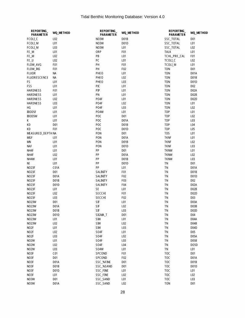
Tidal Benthic Monitoring Database: Version 4.0
28
REPORTING_ PARAMETER WQ_METHOD
FCOLI_C L02 FCOLI_M L01 FCOLI_M L03 FE_M L01 FE_M L02 FE_U L02 FLOW_AVG F01 FLOW_INS F01 FLUOR NA FLUORESCENCE NA FS L01 FSS L01 HARDNESS F01 HARDNESS L01 HARDNESS L02 HARDNESS L03 HG L01 IBOD5F L01 IBOD5W L01 K L01 KD D01 KD F01 MEASURED_DEPTH NA MGF L01 MN L01 NAF L01 NH4F L01 NH4F L02 NH4W L01 NI L01 NO23F C01A NO23F D01 NO23F D01A NO23F D01B NO23F D01D NO23F L01 NO23F L02 NO23F L03 NO23W D01 NO23W D01A NO23W D01B NO23W D01D NO23W L01 NO23W L02 NO2F L01 NO2F L02 NO2F L03 NO2W L01 NO2W L02 NO2W L03 NO3F C01 NO3F D01 NO3F D01A NO3F D01B NO3F D01D NO3F L01 NO3W D01 NO3W D01A
REPORTING_ PARAMETER WQ_METHOD
NO3W D01B NO3W D01D NO3W L01 ORP F01 PB L01 PC L01 PH F01 PH F02 PHEO L01 PHEO L02 PHEO L03 PIC L01 PIP L01 PN L01 PO4F L01 PO4F L02 PO4F L03 PO4W L01 POC D01 POC D01A POC D01B POC D01D PON D01 PON D01A PON D01B PON D01D PP D01 PP D01A PP D01B PP D01D PP L01 SALINITY F01 SALINITY F02 SALINITY F03 SALINITY F04 SE L01 SECCHI F01 SECCHI F02 SIF L01 SIF L02 SIF L03 SIGMA_T D01 SIW L01 SIW L02 SIW L03 SO4F L01 SO4F L02 SO4F L03 SO4F L04 SO4W L01 SPCOND F01 SPCOND F02 SSC_%FINE D01 SSC_%SAND D01 SSC_FINE L01 SSC_FINE L02 SSC_SAND L01 SSC_SAND L02
REPORTING_ PARAMETER WQ_METHOD
SSC_TOTAL D01 SSC_TOTAL L01 SSC_TOTAL L02 TALK L01 TCHL_PRE_CAL F01 TCOLI_C L02 TCOLI_M L01 TDN D01 TDN D01A TDN D01B TDN D01D TDN D02 TDN D02A TDN D02B TDN D02D TDN L01 TDN L02 TDP L01 TDP L02 TDP L03 TDP L04 TDP L05 TDS L01 TKNF L01 TKNF L02 TKNF L03 TKNW L01 TKNW L02 TKNW L03 TN D01 TN D01A TN D01B TN D01D TN D02 TN D02A TN D02B TN D02D TN D03 TN D03A TN D03B TN D03D TN D04 TN D04A TN D04B TN D04D TN D05 TN D05A TN D05B TN DO5D TN L01 TOC D01 TOC D01A TOC D01B TOC D01D TOC L01 TOC L02 TOC L03 TON D01
Tidal Benthic Monitoring Database: Version 4.0
29
REPORTING_ PARAMETER WQ_METHOD
TON D01A TON D01B TON D01D TON D02 TON D02A TON D02B TON D02D TON D03 TON D03A TON D03B TON D03D TOTAL_DEPTH F01 TOTAL_DEPTH F02 TOTAL_DEPTH F03
REPORTING_ PARAMETER WQ_METHOD
TOTAL_DEPTH NA TP D01 TP D01A TP D01B TP D01D TP L01 TP L02 TP L03 TP L04 TP L05 TS L01 TSS L01 TURB_FTU L01 TURB_JTU L01
REPORTING_ PARAMETER WQ_METHOD
TURB_NTU F01 TURB_NTU F02 TURB_NTU L01 TURB_NTU UNK VELOCITY F01 VELOCITY F02 VSS L01 WIDTH F01 WTEMP F01 WTEMP F02 ZN L01 ZNF L02
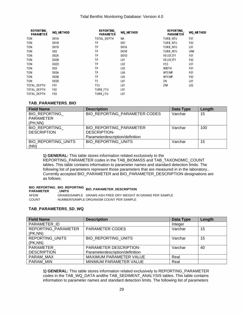
TAB_PARAMETERS_BIO Field Name Description Data Type Length BIO_REPORTING_ PARAMETER (PH,NN)
BIO_REPORTING_PARAMETER CODES Varchar 15
BIO_REPORTING_ DESCRIPTION
BIO_REPORTING_PARAMETER DESCRIPTION-Parameterdescription/definition
Varchar 100
BIO_REPORTING_UNITS (NN)
BIO_REPORTING_UNITS Varchar 15
1) GENERAL: This table stores information related exclusively to the REPORTING_PARAMETER codes in the TAB_BIOMASS and TAB_TAXONOMIC_COUNT tables. This table contains information to parameter names and standard detection limits. The following list of parameters represent those parameters that are measured in in the laboratory.. Currently accepted BIO_PARAMETER and BIO_PARAMETER_DESCRIPTION designations are as follows:
BIO_REPORTING_ PARAMETER
BIO_REPORTING _UNITS BIO_PARAMETER_DESCRIPTION
AFDW GRAMS/SAMPLE GRAMS ASH FREE DRY WEIGHT IN GRAMS PER SAMPLE COUNT NUMBER/SAMPLE ORGANISM COUNT PER SAMPLE
TAB_PARAMETERS_SD_WQ Field Name Description Data Type Length PARAMETER_ID Integer REPORTING_PARAMETER (PK,NN)
PARAMETER CODES Varchar 15
REPORTING_UNITS (PK,NN)
BIO_REPORTING_UNITS Varchar 15
PARAMETER_ DESCRIPTION
PARAMETER DESCRIPTION-Parameterdescription/definition
Varchar 40
PARAM_MAX MAXIMUM PARAMETER VALUE Real PARAM_MIN MINIMUM PARAMETER VALUE Real
1) GENERAL: This table stores information related exclusively to REPORTING_PARAMETER codes in the TAB_WQ_DATA andthe TAB_SEDIMENT_ANALYSIS tables. This table contains information to parameter names and standard detection limits. The following list of parameters

Tidal Benthic Monitoring Database: Version 4.0
30
represent those parameters that are either directly measured in the field or analyzed in the laboratory. Currently accepted REPORTING_PARAMETER and REPORTING_PARAMETER _DESCRIPTION designations are as follows:
REPORTING_ PARAMETER REPORTING_PARAMETER_ DESCRIPTION CARBNATE CARBONTATE CONTENT CARCHN CARBON CONENT-CHN ANALYZER CONDUCT SPECIFIC CONDUCTIVITY DISOXY DISSOLVED OXYGEN DO_PSAT DISSOLVED OXYGEN PERCENT SATURATION INTSAL INTERSTITIAL SALINITY KURT KURTOSIS MEANDIAM MEAN SEDIMENT DIAMETER MEDDIAM MEDIAN SEDIMENT DIAMETER MOIST MOISTURE CONTENT
NITCHN NITROGEN CONTENT-CHN ANALYZER ORP OXIDATION REDUCTION POTENTIAL PENETR GEAR PENETRATION DEPTH PH PH QUARTDEV QUARTILE DEVIATION SALINITY SALINITY SAND SAND CONTENT, PERCENT SILT SILT CONTENT, PERCENT SILTCLAY SILT CLAY CONTENT, PERCENT SKEW SKEWNESS SORT SORTING VOLORG VOLATILE ORGANIC, PERCENT WTEMP WATER TEMPERATURE, CENTEGRAGE
TAB_PELLETS Field Name Description Data Type Length PELLETS (PK,NN)
FECAL PELLET CLASSIFICATION Varchar 10
PELLETS _DESCRIPTION DESCRIPTION OF PELLET CLASSIFICATION
Varchar 50
1) GENERAL: This table stores information identifying fecal pellet abundance classifications from the Sediment Profile Camera images. The current fecal pellet density classifications are as follows:
PELLETS DESCRIPTION FEW 1 TO 6 PELLETS IND INDETERMINATE LAYER PELLETS COVER SEDIMENT WATER INTERFACE MANY GREATER THAN 18 PELLETS NA NO ANALYSIS NONE 0 PELLETS SOME 7 TO 18 PELLETS
TAB_PHOTO_PARAMETER Field Name Description Data Type Length PHOTO_ANALYSIS _ PARAMETER (PK,NN)
PHOTO_ANALYSIS PARAMETER CODES Varchar 20
PHOTO_ANALYSIS_ PARAMETER_ DESCRIPTION
PHOTO_ANALYSIS_PARAMETER DESCRIPTION-Parameter description/definition
Varchar 50
REPORTING_UNITS (NN)
PHOTO_ANALYSIS_PARAMETER REPORTING UNITS
Varchar 20
1) GENERAL: This table stores information pertaining to the image parameters observed in the Sediment Profile Camera images. The current PHOTO_PARAMETERS are as follows:

Tidal Benthic Monitoring Database: Version 4.0
31
PHOTO_ANALYSIS _PARAMETER PHOTO_ANALYSIS _DESCRIPTION REPORTING_UNITS BURROWS NUMBER OF BURROWS COUNT GAS VOID DEPTH DEPTH OF GAS VOIDS CENTIMETERS GAS VOIDS NUMBER OF GAS FILLED VOIDS COUNT INFAUNA NUMBER OF INFAUNA ORGANISMS COUNT INFAUNA DEPTH DEPTH OF INFAUNA OBSERVED CENTIMETERS PENETRATION GEAR PENETRATION DEPTH CENTIMETERS RPD REDOX POTENTIAL DISCONTINUITY LAYER DEPTH CENTIMETERS SURFACE RELIEF SURFACE RELIEF CENTIMETERS VOID DEPTH DEPTH OF WATER VOIDS CENTIMETERS WATER VOIDS NUMBER OF WATER FILLED VOIDS CENTIMETERS
TAB_PHOTO_QUALIFIERS Field Name Description Data Type Length PHOTO_ QUALIFIERS (PK,NN)
QUALIFIER CODE Parameter value qualifier code
Char 2
PHOTO_ QUALIFIERS _ DESCRIPTION (NN)
DESCRIPTION definition of QUALIFIER
Varchar 120
1) GENERAL: This table stores information related exclusively to the Qualifiers codes in the TAB_PHOTO_ANALYSIS table. The PHOTO_QUALIFIER code is used to describe the parameter value. Currently accepted QUALIFIERS and DESCRIPTION designations are as follows:
PHOTO_
QUALIFIER PHOTO_QUALIFIER
_DESCRIPTION # Trace (less than an unknown detectable value)< Less than the detection limit of the method > Greater than detection limit of method A Within Range I INDETERMINATE J Estimated value N Not detected NA Not recorded/parameter value not acceptable R RANGE OF VALUES SB SHELL BED
TAB_PROGRAM Field Name Description Data Type Length PROGRAM (PK,NN)
MONITORING PROGRAM-Code identifying State Monitoring Program
Char 10
PROGRAM_ DESCRIPTION (NN)
PROGRAM_DESCRIPTION-Detailed discription of monitoring program
Varchar 100
1) GENERAL: TAB_PROGRAM stores information related to the PROGRAM codes in TAB_EVENTS. The PROGRAM code was added to the database design because Maryland DNR has adopted a project-oriented approach to Monitoring Program data management. This approach relies upon the use of PROGRAM and PROJECT codes. Current Program codes in the data base include:
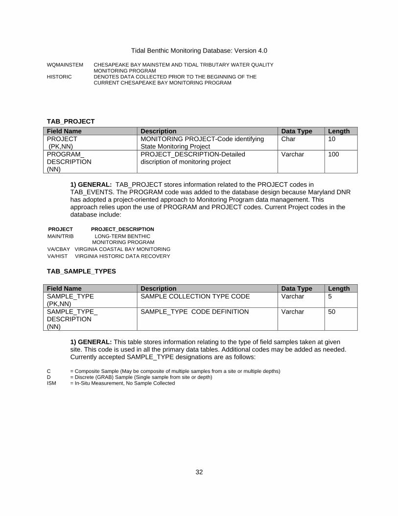
Tidal Benthic Monitoring Database: Version 4.0
32
WQMAINSTEM CHESAPEAKE BAY MAINSTEM AND TIDAL TRIBUTARY WATER QUALITY MONITORING PROGRAM
HISTORIC DENOTES DATA COLLECTED PRIOR TO THE BEGINNING OF THE CURRENT CHESAPEAKE BAY MONITORING PROGRAM
TAB_PROJECT Field Name Description Data Type Length PROJECT (PK,NN)
MONITORING PROJECT-Code identifying State Monitoring Project
Char 10
PROGRAM_ DESCRIPTION (NN)
PROJECT_DESCRIPTION-Detailed discription of monitoring project
Varchar 100
1) GENERAL: TAB_PROJECT stores information related to the PROJECT codes in TAB_EVENTS. The PROGRAM code was added to the database design because Maryland DNR has adopted a project-oriented approach to Monitoring Program data management. This approach relies upon the use of PROGRAM and PROJECT codes. Current Project codes in the database include:
PROJECT PROJECT_DESCRIPTION MAIN/TRIB LONG-TERM BENTHIC
MONITORING PROGRAM VA/CBAY VIRGINIA COASTAL BAY MONITORINGVA/HIST VIRGINIA HISTORIC DATA RECOVERY
TAB_SAMPLE_TYPES Field Name Description Data Type Length SAMPLE_TYPE (PK,NN)
SAMPLE COLLECTION TYPE CODE Varchar 5
SAMPLE_TYPE_ DESCRIPTION (NN)
SAMPLE_TYPE CODE DEFINITION Varchar 50
1) GENERAL: This table stores information relating to the type of field samples taken at given site. This code is used in all the primary data tables. Additional codes may be added as needed. Currently accepted SAMPLE_TYPE designations are as follows:
C = Composite Sample (May be composite of multiple samples from a site or multiple depths) D = Discrete (GRAB) Sample (Single sample from site or depth) ISM = In-Situ Measurement, No Sample Collected

Tidal Benthic Monitoring Database: Version 4.0
33
TAB_SAMPLING_GEAR Field Name Description Data Type Length SOURCE (PK,NN)
DATA GENERATING AGENCY-Code identifying data generator
Varchar 10
G_METHOD (PK,NN)
GEAR METHOD CODE-Code of Sampling Gear used for sample collection
Char 3
G_CONVERSION_FACT (NN)
CONVERSION FACTOR-(#/SAMPLE TO #/AREA SQUARED)
Real
G_DESCRIPTION (NN) GEAR DESCRIPTION-Description of Sampling Gear
Varchar 40
G_CONVERSION_UNITS (NN)
UNITS FOR CONVERSION FACTOR Char 9
SOURCE_G_CODE SOURCE_G_CODE-Data generator inhouse gear code
Varchar 100
1) GENERAL: This table stores information relating to the type of gear used to collect benthic samples for both biomass and taxonomic identification. This table stores not only the code identifications for sampling gear but also the necessary conversion values to convert from sample to area. These codes are used primary in TAB_BIOTA_SAMPLING. The primary key in this table is defined by G_METHOD and SOURCE since multiple agencies have identical pieces of sampling gear of differing sizes (and thus differing conversion factors). Currently accepted designations are as follows:
SOURCE G_METHOD G_CONVERSION
_FACT G_DESCRIPTION G_CONVERSION _UNITS
EA 17 14.33 PONAR GRAB (200 SQ CM) SAMPLE/M2 EA 19 6.8 PONAR GRAB (50 SQ CM) SAMPLE/M2 ODU 20 57.24 BOX CORE GRAB (UNSPECIFIED) SAMPLE/M2 ODU 82 40.4 PETITE PONAR GRAB SAMPLE/M2 ODU 83 20.2 DOUBLE PETITE PONAR GRAB (50 SQ CM) SAMPLE/M2 ODU 97 22.68 YOUNG MODIFIED VAN VEEN GRAB (0.04 SQ M) SAMPLE/M2 VERSAR 16 40 POST HOLE DIGGER (0.025 SQ M) SAMPLE/M2 VERSAR 20 45 BOX CORE GRAB (225 SQ CM) (45.45) SAMPLE/M2 VERSAR 96 10 HYDROLIC VAN VEEN GRAB (0.1 SQ METER) SAMPLE/M2 VERSAR 97 22.73 YOUNG MODIFIED VAN VEEN GRAB (0.04 SQ M) SAMPLE/M2 VERSAR 98 40 PETITE PONAR GRAB (25 SQ CM) SAMPLE/M2 VIMS 19 6.67 PONAR GRAB SAMPLE/M2 VIMS 24 10 SMITH-MACINTIRE GRAB (1 SQ M) SAMPLE/M2 VIMS 81 16.67 SPADE BOX CORE (0.06 SQ M) SAMPLE/M2 VIMSTI 99 3.33 SMITH-MACINTIRE GRAB (0.3 SQ M) SAMPLE/M2 VIMSWO 100 5 SMITH-MACINTIRE GRAB (0.2 SQ M) SAMPLE/M2

Tidal Benthic Monitoring Database: Version 4.0
34
TAB_SAMPLING_STRATA Field Name Description Data Type Length STRATUM (PK)
SAMPLING STRATUM CODE-Code describing sampling stratum
Text 6
STRATUM_DESCRIPTION SAMPLING STRATA DESCRIPTION-Physical or Geographical description of Stratum
Text 255
BASIN (NN) BASIN OR TRIBUTARY CODE-Largest drainage basin (aside from Chesapeake Bay) With which the station is associated
Text 20
BOUNDING_LATITUDE _NORTH (NN)
NORTHERN BOUNDARY-Northern most coordinate of the limit of the strata expressed in latitude in decimal degrees (NAD83)
Decimal 9,6
BOUNDING_LONGITUDE _EAST (NN)
EASTERN BOUNDARY-Eastern most coordinate of the limit of the strata expressed in longitude in decimal degrees (NAD83)
Decimal 9,6
BOUNDING_LATITUDE _SOUTH (NN)
SOUTHERN BOUNDARY-Southern most coordinate of the limit of the strata expressed in latitude in decimal degrees (NAD83)
Decimal 9,6
BOUNDING_LONGITUDE _WEST (NN)
WESTERN BOUNDARY-Western most coordinate of the limit of the strata expressed in longitude in decimal degrees (NAD83)
Decimal 9,6
1) GENERAL: This table stores information relating additional geographic attributes of sampling stations in the TAB_EVENT table. Theattributes including researcher defined habitat stratum and river basins. Note that all coordinates are currently in the NAD83 projection. Current sampling stratum are as follows
STRATUM STRATUM_DESCRIPTION 101 Calvert Cliffs 102 Calvert Cliffs 103 Calvert Cliffs 104 Holland Point 105 Holland Point 106 Bloody Point 107 Bodkin Point 108 Poole's Island 109 Turkey Point 110 Point Lookout 111 Point Lookout 112 St Clements Island 113 St Clements Island 114 Morgantown 115 Morgantown 116 Maryland Point 117 Rosier Bluff
STRATUM STRATUM_DESCRIPTION118 Todd's Point 119 Todd's Point 120 Jamaica Point 121 King's Creek 122 Piney Point 123 Frying Pan Point 124 Sparrows Point 125 Bear Creek 126 Curtis Bay 127 Middle Branch 128 Broomes Island 129 Broomes Island 130 Chalk Point 131 Jug Bay BAY Virginia Lower Bay ELZ Elizabeth River JAM James River
STRATUM STRATUM_DESCRIPTIONLAR Large Estuary MET Maryland Eastern
Tributaries MMS Maryland Mainstem MWT Maryland Western
Tributaries PAR Paradise Creek PAT Baltimore Harbor,Patapsco
River PMR Potomac River PXR Patuxent River RAP Rappahanock River SML Small Estuary TID Tidal River UPB Maryland Upper Bay VACB VIRGINIA COASTAL BAYSYRK York River
2) BASIN: Basin is defined as the largest drainage basin (aside from Chesapeake Bay) With which the station is associated. The SUBBASIN refers to the second largest drainage basin. In some cases the BASIN and SUBBASIN values will be the same. Currently accepted BASIN designations are as follows:

Tidal Benthic Monitoring Database: Version 4.0
35
CHESAPEAKE BAY PATAPSCO RIVER ELIZABETH RIVER CHESTER RIVER PATUXENT RIVER YORK RIVER CHOPTANK RIVER POTOMAC RIVER JAMES RIVER CHOPTANK RIVER RAPPAHANOCK RIVER. 3) BOUNDING COORDINATES: Refers to the limits of coverage of a data set expressed by latitude and longitude values in the order western-most, eastern-most, northern-most, and southern-most. For data sets that include a complete band of latitude around the earth, the West Bounding Coordinate shall be assigned the value -180.0, and the East Bounding Coordinate shall be assigned the value 180.0
TAB_SEDIMENT_TYPE Field Name Description Data Type Length SEDIMENT TYPE (PK,NN)
SEDIMENT TYPE CLASSIFICATION Varchar 15
SEDIMENT_TYPE_ DESCRIPTION (NN)
WENTWORTH SEDIMENT TYPE CLASSIFICATION DESCRIPTION
Varchar 50
1) GENERAL: This table stores information pertaining to the Wentworth sediment classifications for sites based on the Sediment Profile Camera images found in TAB_PHOTO_EVENT. SEDIMENT_TYPE- The current Wentworth Sediment classifications in use are as follows:
SEDIMENT TYPE DESCRIPTION CL CLAY CLMS CLAY-MEDIUM SAND CLSH CLAY-SHELL CLSI CLAY-SILT CLSI/SH CLAY-SILT-SHELL CLSIFS CLAY-SILT-FINE SAND FS FINE SAND FS/FSSI FINE SAND-FINE SANDY SILT FS/SI FINE SAND- SILT FS/SICL FINE SAND-SILTY CLAY FSCL FINE SAND-CLAY FSGR FINE SAND-GRAVEL FSMS FINE SAND-MEDIUM SAND FSMS/SI FINE SAND-MEDIUM SAND- SILT FSMSSH/SI FINE SAND-MEDIUM SAND-SHELL-SILT FSSH FINE SAND -SHELL
FSSICL FINE SAND-SILT-CLAY FSSISH FINE SAND-SILT-SHELL IND INDETERMINATE MFSCL MEDIUM FINE SAND-CLAY MS MEDIUM SAND MSC MEDIUM SAND-CLAY MSGR MEDIUM SAND-GRAVEL NA NOT AVAILABLE SA/SICL SAND-SILTYCLAY SACL SANDY CLAY SASH SAND-SHELL SASI SANDY SILT SH SHELL SHFS SHELL-FINE SAND SHFSSI/CL SHELL-FINE SAND-SILT-CLAY SHSA SHELL-SAND SHSICL SHELL-SILT-CLAY SI SILT SICL SILTY CLAY
SICL/SH SILTY CLAY-SHELL SICLFS SILTY CLAY-FINE SAND SIFS SILTY FINE SAND SIFSMS SILTY FINE SAND - MEDIUM SAND SISA SILTY SAND SISACL SILTY SANDY CLAY SISH SILTY SHELL

Tidal Benthic Monitoring Database: Version 4.0
36
TAB_SEGS_2003 Field Name Description Type Length CBSEGS_2003 (PK, NN)
2003 CHESAPEAKE BAY PROGRAM MONITORING SEGMENT CODE
CHAR 6
CBSEGS_2003_ DESCRIPTION (NN)
2003 MONITORING SEGMENT DESCRIPTION
VARCHAR 50
1) GENERAL- This table stores information relating additional geographic attributes of sampling stations in the TAB_EVENT table. The monitoring segment codes describing in which segment a station is located. It is based upon the new segmentation scheme developed in 1997, revised in 2000 and 2003. The currently accepted CBSEGS_2003 values and DESCRIPTIONS are as follows:
CBSEG_2003 CBSEG_2003_DESCRIPTION ANATF ANACOSTIA RIVER-TIDAL FRESH REGION APPTF APPOMATTOX RIVER-TIDAL FRESH REGION BACOH BACK RIVER-OLIGOHALINE REGION BIGMH BIG ANNEMESSEX RIVER-MESOHALINE REGION BOHOH BOHEMIA RIVER-OLIGOHALINE REGION BSHOH BUSH RIVER-OLIGOHALINE REGION C&DOH C&D CANAL-OLIGOHALINE REGION CB1TF CHESAPEAKE BAY-TIDAL FRESH REGION CB2OH CHESAPEAKE BAY-OLIGOHALINE REGION CB3MH CHESAPEAKE BAY-MESOHALINE REGION CB4MH CHESAPEAKE BAY-MESOHALINE REGION CB5MH CHESAPEAKE BAY-MESOHALINE REGION CB6PH CHESAPEAKE BAY-POLYHALINE REGION CB7PH CHESAPEAKE BAY-POLYHALINE REGION CB8PH CHESAPEAKE BAY-POLYHALINE REGION CHKOH CHICKAHOMINY RIVER-OLIGOHALINE REGION CHOMH1 CHOPTANK RIVER-MESOHALINE REGION 1 CHOMH2 CHOPTANK RIVER-MESOHALINE REGION 2 CHOOH CHOPTANK RIVER-OLIGOHALINE REGION CHOTF CHOPTANK RIVER-TIDAL FRESH REGION CHSMH CHESTER RIVER-MESOHALINE REGION CHSOH CHESTER RIVER-OLIGOHALINE REGION CHSTF CHESTER RIVER-TIDAL FRESH REGION CRRMH CORROTOMAN RIVER-MESOHALINE REGION EASMH EASTERN BAY-MESOHALINE REGION EBEMH EAST BRANCH ELIZABETH RIVER-MESOHALINE
REGION ELIMH ELIZABETH RIVER-MESOHALINE REGION ELIPH ELIZABETH RIVER-POLYHALINE REGION ELKOH ELK RIVER-OLIGOHALINE REGION FSBMH FISHING BAY-MESOHALINE REGION GUNOH GUNPOWDER RIVER-OLIGOHALINE REGION GUNTF GUNPOWDER RIVER-TIDAL FRESH REGION HNGMH HONGA RIVER-MESOHALINE REGION JMSMH JAMES RIVER-MESOHALINE REGION JMSOH JAMES RIVER-OLIGOHALINE REGION JMSPH JAMES RIVER-POLYHALINE REGION JMSTF JAMES RIVER-TIDAL FRESH REGION LAFMH LAFAYETTE RIVER-MESOHALINE REGION LCHMH LITTLE CHOPTANK RIVER-MESOHALINE REGION LYNPH LYNNHAVEN RIVER-POLYHALINE REGION MAGMH MAGOTHY RIVER-MESOHALINE REGION MANMH MANOKIN RIVER-MESOHALINE REGION
CBSEG_2003 CBSEG_2003_DESCRIPTION MATTF MATTAWOMAN CREEK-TIDAL FRESH REGION MIDOH MIDDLE RIVER-OLIGOHALINE REGION MOBPH MOBJACK BAY-POLYHALINE REGION MPNOH MATTAPONI RIVER-OLIGOHALINE REGION MPNTF MATTAPONI RIVER-TIDAL FRESH REGION NANMH NANTICOKE RIVER-MESOHALINE REGION NANOH NANTICOKE RIVER-OLIGOHALINE REGION NANTF NANTICOKE RIVER-TIDAL FRESH REGION NORTF NORTHEAST RIVER-TIDAL FRESH REGION PATMH PATAPSCO RIVER-MESOHALINE REGION PATTF PATAPSCO RIVER-TIDAL FRESH REGION PAXMH PATUXENT RIVER-MESOHALINE REGION PAXOH PATUXENT RIVER-OLIGOHALINE REGION PAXTF PATUXENT RIVER-TIDAL FRESH REGION PIAMH PIANKATANK RIVER-MESOHALINE REGION PISTF PISCATAWAY CREEK-TIDAL FRESH REGION PMKOH PAMUNKEY RIVER-OLIGOHALINE REGION PMKTF PAMUNKEY RIVER-TIDAL FRESH REGION POCMH POCOMOKE RIVER-MESOHALINE REGION POCOH POCOMOKE RIVER-OLIGOHALINE REGION POCTF POCOMOKE RIVER-TIDAL FRESH REGION POTMH POTOMAC RIVER-MESOHALINE REGION POTOH POTOMAC RIVER-OLIGOHALINE REGION POTTF POTOMAC RIVER-TIDAL FRESH REGION RHDMH RHODE RIVER-MESOHALINE REGION RPPMH RAPPAHANNOCK RIVER-MESOHALINE REGION RPPOH RAPPAHANNOCK RIVER-OLIGOHALINE REGION RPPTF RAPPAHANNOCK RIVER-TIDAL FRESH REGION SASOH SASSAFRAS RIVER-OLIGOHALINE REGION SBEMH SOUTH BRANCH ELIZABETH RIVER-MESOHALINE
REGION SEVMH SEVERN RIVER-MESOHALINE REGION SOUMH SOUTH RIVER-MESOHALINE REGION SUSTF SUSQUEHANNA RIVER-TIDAL FRESH REGION TANMH TANGIER SOUND-MESOHALINE REGION WBEMH WEST BRANCH ELIZABETH RIVER-MESOHALINE
REGION WBRTF WESTERN BRANCH-TIDAL FRESH REGION WICMH WICOMICO RIVER-MESOHALINE REGION WSTMH WEST RIVER-MESOHALINE REGION YRKMH YORK RIVER-MESOHALINE REGION YRKPH YORK RIVER-POLYHALINE REGION
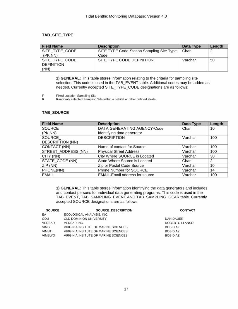
Tidal Benthic Monitoring Database: Version 4.0
37
TAB_SITE_TYPE Field Name Description Data Type Length SITE_TYPE_CODE (PK,NN)
SITE TYPE Code-Station Sampling Site Type Code
Char 2
SITE_TYPE_CODE_ DEFINITION (NN)
SITE TYPE CODE DEFINITION Varchar 50
1) GENERAL: This table stores information relating to the criteria for sampling site selection. This code is used in the TAB_EVENT table. Additional codes may be added as needed. Currently accepted SITE_TYPE_CODE designations are as follows:
F Fixed Location Sampling Site R Randomly selected Sampling Site within a habitat or other defined strata..
TAB_SOURCE Field Name Description Data Type Length SOURCE (PK,NN)
DATA GENERATING AGENCY-Code identifying data generator
Char 10
SOURCE_ DESCRIPTION (NN)
DESCRIPTION Varchar 100
CONTACT (NN) Name of contact for Source Varchar 100 STREET_ADDRESS (NN) Physical Street Address Varchar 100 CITY (NN) City Where SOURCE is Located Varchar 30 STATE_CODE (NN) State Where Source is Located Char 2 ZIP (NN) Zip or Postal Code Source Varchar 10 PHONE(NN) Phone Number for SOURCE Varchar 14 EMAIL EMAIL-Email address for source Varchar 100
1) GENERAL: This table stores information identifying the data generators and includes and contact persons for individual data generating programs. This code is used in the TAB_EVENT, TAB_SAMPLING_EVENT AND TAB_SAMPLING_GEAR table. Currently accepted SOURCE designations are as follows:
SOURCE SOURCE_DESCRIPTION CONTACT
EA ECOLOGICAL ANALYSIS, INC. ODU OLD DOMINION UNIVERSITY DAN DAUER VERSAR VERSAR INC. ROBERTO LLANSO VIMS VIRGINIA INSITUTE OF MARINE SCIENCES BOB DIAZ VIMSTI VIRGINIA INSITUTE OF MARINE SCIENCES BOB DIAZ VIMSWO VIRGINIA INSITUTE OF MARINE SCIENCES BOB DIAZ

Tidal Benthic Monitoring Database: Version 4.0
38
TAB_TUBE_CODES Field Name Description Data Type Length TUBES_CODE (PK,NN)
FAUNA TUBE ABUNDANCE CLASSIFICATION
Varchar 8
TUBE_CODE_ DESCRIPTION (NN)
CLASSIFICATION DESCRIPTION Varchar 50
1) GENERAL: This table stores information identifying Faunal Tube abundance classifications from the Sediment Profile Camera images found in TAB_PHOTO_EVENT table. The current faunal tube density classifications are as follows:
TUBES DESCRIPTION FEW 1 TO 6 TUBES IND INDETERMINATE LAYER PELLETS COVER SEDIMENT WATER INTERFACE MANY GREATER THAN 18 TUBES NA NO ANALYSIS NONE 0 TUBES SOME 7 TO 18 TUBES
TAB_VALUE_TYPE Field Name Description Data Type Length VALUE_TYPE (PK,NN)
VALUE TYPE CODE Char 3
DEFINITION VALUE_TYPE CODE DEFINITON Varchar 50
1) GENERAL: This table stores information relating to the type of measurement a parameter is. This code is used primary in the BIOMASS_TABLE and BIOTA_TABLE. Additional codes may be added as needed. Currently accepted VALUE_TYPE designations are as follows:
A = Actual Measurement of a parameter value E = Estimated Measurement of a parameter value

Tidal Benthic Monitoring Database: Version 4.0
39
SECONDARY LOOK-UP TABLES The secondary look-up tables are present in the database but are not linked to the main or primary look-up tables of the database. They can be used in queries to add additional fields exclusively to the WQ_DATA table. They include codes related to parameter names, sampling methods, and laboratory analysis of water quality samples.
TAB_BAY_CRUISE Field Name Description Data Type Length CRUISE (PK,NN)
OLD CBP CRUISE NUMBER
CHAR 6
START_DATE (U,NN)
STARTING DATE OF CRUISE SMALLDATETIME
8
END_DATE (U,NN)
ENDING DATE OF CRUISE SMALLDATETIME
8
NEWCRUISE
NEWCRUISE-1998 CBP cruise designation
CHAR 7
1) GENERAL: This table stores information relating to the time periods of water quality Monitoring Cruises. Cruise periods are a tool used as a data grouping mechanism for analysis. The field NEWCRUISE was a proposed system for reassigning cruise numbers that was never fully adapted.Please see database for complete cruise list.
TAB_PI_SPECIES_TABLE Field Name Description Data Type Length SOURCE (PK,FK,NN) DATA GENERATING AGENCY-Code
identifying data generator Char 10
SPEC_CODE (PK,NN) SOURCE IN-HOUSE SPECIES CODE Varchar 14 SOURCE_LBL (NN) SOURCE IN-HOUSE SPECIES LATIN NAME Varchar 45 LBL FULL SPECIES LABEL (INCLUDES
LIFESTAGE)-Latin Name Corrected to IT IS accepted spelling
Varchar 45
R_DATE(NN) VERSION DATE-Date denoting when data records were entered in to database
Small Date/Time
TSN(PK,FK NN) TAXON SERIAL NUMBER-ITIS Serial Number for Species Identification
Char 7
LIFE_STAGE_CODE (NN)
SPECIES LIFESTAGE-Additional species identifier
Char 3
TAXON_GROUP FUNCTIONAL TAXONOMIC GROUP-AdditionalTaxonomic information
Varchar 25
FEEDING_GROUP FUNCTIONAL FEEDING GROUP-Additional Taxonomic information
Varchar 20
SENSITIVITY POLLUTION SENSITIVITY-Additional Taxonomic information: PI-POLLUTION INDICATIVE, PS-POLLUTION SENSITIVE
Varchar 4

Tidal Benthic Monitoring Database: Version 4.0
40
1) General: This table stores information relating to the Source SPEC_CODE. This database uses the Interagency Taxonomic Identification System (ITIS) Taxon Serial Numbers (TSN) for species identification within the database. For species with no TSN values temporary Chesapeake Bay TSNs are generated until a species can be submitted to ITIS for recognition. All data generators had developed and implemented internal species coding systems prior to the development of the ITIS standard. This table is provided as a conversion table from Source in-house species codes to ITIS TSN’s prior to loading data to either the BIOMASS_TABLE or the TAXONOMIC_TABLE. Additional benthic species grouping keys have been added to this table for use in calculating Benthic Indexes of Biotic Integrity and routine calculated in the various Chesapeake Bay Water Quality and Ecosystem models.

Tidal Benthic Monitoring Database: Version 4.0
41
DATA LOADING PROCEDURES
The following procedures outline the steps for loading data into the various major database tables. These are general directions and not meant to cover every possible problem, which may arise when loading data. There is no substitute for having a skilled data manager who is knowledgeable in both environmental data and relational databases.
MARYLAND AND VIRGINIA BENTHIC DATA LOADING PROTOCOL These loading procedures assume that data to be added into the database are available in a comma delimited ASCII format in a predetermined format. All monitoring programs have been provided with PC SAS programs to the data generators to create the necessary files for loading of data into the database. Loading of tables must be performed in a predetermined order due to the referential integrity requirements of the relational database. The loading order of tables is as follows: the Benthic Event table followed by the Biota Event table. The TAB_PI_SPECIES_LIST updated and any additions that need to bemade to the TAB_CBP_MASTER species table should be done before any taxonomic or biomass data is loaded to the database. The remaining data tables may be then loaded in any order.
BENTHIC EVENT DATA 1) The comma delimited ASCII file available for data loading should contain a header row
followed by rows of data in the following format and order:
FIELD FORMAT STATION TEXT (CHAR 15)
SAMPLE_DATE DATE YYYYMMDD (May Have Date Delimiters)
STRATUM TEST(CHAR 4) LATITUDE NUMERIC (8.4) (NAD83)
LONGITUDE NUMERIC (8.4) (NAD83) SITE_TYPE TEXT(CHAR 2)
SAMPLE_TIME DATE/TIME (24 HH:MM) SOURCE TEXT (CHAR 8)
TOTAL_DEPTH NUMERIC (8.1) YEARCODE TEXT (CHAR 8) CRUISENO TEXT (CHAR 8) STAEQ85 TEXT (CHAR 8)
SITE TEXT (CHAR 8) SAMPTYPE TEXT (CHAR 8)
2) Open the database in Microsoft Access and follow the import procedure outlined as follows:
a) Next, select NEW, followed by IMPORT TABLE and click on OK. b) A common dialog box will come up. Change the File type to ASCII and select the file to import. (The CBP provided program should have named the MDBEEV.TXT). Then click on IMPORT. c) At this point the Microsoft file import wizard will come up to help you with the file import. Proceed by setting the file type to comma delimited ASCII using the control buttons and then press NEXT. d) On the next screen CLICK -FIRST LINE IS HEADER ROW BOX. Make sure the field delimiter is set correctly it should be a comma. Then press the ADVANCED button.. e) In the Advanced menu set the following formats: Date format is YMD, check four digit year and leading zeros on dates, set a hyphen (-) as the date delimiter (Note this will have to be changed if the SAS program was modified to use another delimiter or date format). Make sure the Data/Field types are set correctly (see table in step one for correct field types). The fields STATION,

Tidal Benthic Monitoring Database: Version 4.0
42
STAEQ85, SITE will need to be corrected. Once things are properly set, CLICK OK and NEXT. f) On the following screen SELECT IMPORT AS NEW TABLE, then NEXT. g) The next screen will allow you to double check each of the field types and import formats for the data set. Confirm each of the fields against the table above. You can press the advanced key to go back and modify anything that needs to be changed at this point. Then click on NEXT. h) Select NO PRIMARY KEY and FINISH. This completes the import procedure.
3) Run data quality checks for appropriate station Ids, valid STRATUM, SITE_TYPE, AND SOURCE assignments, (i.e. Stratums in the data must be in the Sampling_Strata _Table or data will not load) and other missing key/not null fields as indicated in the Survey _Table. It may be necessary to run a check for duplicate records based on key fields using built in query wizard. Your working table is named MDBEEV.
4) Append the working file to Load Survey Table Template. 5) Merge UTM_X, UTM_Y, CBSEG2003, HUC_8 and FIPS codes on to the Load Survey Table
from your GIS applications. 6) Run the query UPDATE SURVEY1. (This query will merge in some CBP required constants) 7) Run the query APPEND TO SURVEY2. (This query will add the new data to the existing
Survey_Table, provided there are no referential integrity issues. It will also assign the Survey_ID number for each sampling event.
8) Run the UPDATE EVENT_ID query. This query will merge the EVENT_ID numbers back on to the working EVENT file. This file will be used in later data processing to assign EVENT_ID numbers to all of the remaining data. (HIS-Strata need to be coded with STAEQ85 Value.)
BENTHIC BIOTA EVENT DATA 1) The comma delimited ASCII file available for data loading should contain a header row
followed by rows of data in the following format and order:
FIELD FORMAT STATION TEXT (CHAR 15)
SAMPLE_DATE DATE YYYYMMDD (May Have Date Delimiters)
SAMPLE_TIME DATE/TIME (24 HH:MM) SAMPLE_NUMB
ER NUMERIC(8.0)
GMETHOD TEXT(CHAR 5) NET_MESH NUMERIC(8.1)
PENETR NUMERIC(8.2) SER_NUM TEXT(CHAR 12) SOURCE TEXT (CHAR 8)
YEARCODE TEXT (CHAR 8) CRUISENO TEXT (CHAR 6) STAEQ85 TEXT (CHAR 8) STAEQ89 TEXT (CHAR 8)
SITE TEXT (CHAR 8). 2) Open the database in Microsoft Access and follow the import procedure outlined as follows:
a) Next, select NEW, followed by IMPORT TABLE and click on OK. b) A common dialog box will come up. Change the File type to ASCII and select the file to import.(The CBP provided program should have named the MDBEBEEV.TXT). Then click on IMPORT. c) At this point the Microsoft file import wizard will come up to help you with the file import. Proceed by setting the file type to comma delimited ASCII using the control buttons and then press NEXT. d) On the next screen CLICK THE FIRST LINE IS HEADER ROW BOX. Make sure the field delimiter is set correctly it should be a comma. Then press the ADVANCED button.

Tidal Benthic Monitoring Database: Version 4.0
43
e) In the Advanced menu set the following formats: Date format is YMD, check four digit year and leading zeros on dates, set a hyphen (-) as the date delimiter (Note this will have to be changed if the SAS program was modified to use another delimiter or date format). Make sure the Data/Field types are set correctly (see table in step one for correct field types). The fields STATION, STAEQ85, STAEQ89 ,SITE will probably need to be corrected. Once things are properly set, CLICK OK and NEXT. f) On the following screen SELECT IMPORT AS NEW TABLE, then NEXT. g) The next screen will allow you to double check each of the field types and import formats for the data set. Confirm each of the fields against the table above. You can press the advanced key to go back and modify anything that needs to be changed at this point. Then click on NEXT. h) Select NO PRIMARY KEY and FINISH. This completes the import procedure.
3) Run data quality checks for appropriate station Ids, and other missing key/not null fields as indicated in the BIOTA_EVENT _Table. Run an unmatched query between the MDBEBEEV and the MDBEEEV table. Every record in the BIOTA EVENT table must have a record in the TAB_EVENT table. It may be necessary to run a check for duplicate records based on key fields using built in query wizard. Your working table is named MDBEBEEV.
4) Append the working file to LOAD_BIOTA_EVENT Table Template. 5) Run the query APPEND TO LOAD BIOTA AND CONSTANTS. (This query will merge in
some CBP required constants and Chesapeake Bay Program sampling Gear codes.) 6) Run the UPDATE EVENT_ID_BIOTA query. This query will merge the EVENT_ID numbers
back on to the working BIOTA file. 7) Run the query APPEND TO LOAD BIOTA TO RDBMS. (This query will add the new data to
the existing TAB_BIOTA_SAMPLING, provided there are no referential integrity issues.).
BENTHIC WATER QUALITY DATA 1) The comma delimited ASCII file available for data loading should contain a header row
followed by rows of data in the following format and order:
FIELD FORMAT STATION TEXT (CHAR 15)
SAMPLE_DATE DATE YYYYMMDD (May Have Date Delimiters)
SAMPLE_TIME DATE/TIME (24 HH:MM) SAMPLE_NUMBER NUMERIC(8.0) SAMPLE_DEPTH NUMERIC (8.1)
PARAMETER TEXT (CHAR 20) VALUE NUMERIC(12.4) UNITS TEXT(CHAR 12)
INS_CODE TEXT (CHAR 8) SOURCE TEXT (CHAR 8)
LABEL TEXT (CHAR 50) YEARCODE TEXT (CHAR 8) CRUISENO TEXT (CHAR 6) STAEQ85 TEXT (CHAR 8) STAEQ89 TEXT (CHAR 8)
SITE TEXT (CHAR 8) SAMPLE_TYPE TEXT (CHAR 2)
2) Open the database in Microsoft Access and follow the import procedure outlined as follows:
a) Next, select NEW, followed by IMPORT TABLE and click on OK. b) A common dialog box will come up. Change the File type to ASCII and select the file to
import. (The CBP provided program should have named the MDBEWQ.TXT). Then click on IMPORT.
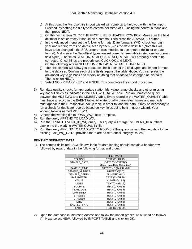
Tidal Benthic Monitoring Database: Version 4.0
44
c) At this point the Microsoft file import wizard will come up to help you with the file import. Proceed by setting the file type to comma delimited ASCII using the control buttons and then press NEXT.
d) On the next screen CLICK THE FIRST LINE IS HEADER ROW BOX. Make sure the field delimiter is set correctly it should be a comma. Then press the ADVANCED button.
e) In the Advanced menu set the following formats: Date format is YMD, check four digit year and leading zeros on dates, set a hyphen (-) as the date delimiter (Note this will have to be changed if the SAS program was modified to use another delimiter or date format). Make sure the Data/Field types are set correctly (see table in step one for correct field types). The fields STATION, STAEQ85, STAEQ89 ,SITE will probably need to be corrected. Once things are properly set, CLICK OK and NEXT.
f) On the following screen SELECT IMPORT AS NEW TABLE, then NEXT. g) The next screen will allow you to double check each of the field types and import formats
for the data set. Confirm each of the fields against the table above. You can press the advanced key to go back and modify anything that needs to be changed at this point. Then click on NEXT.
h) Select NO PRIMARY KEY and FINISH. This completes the import procedure.
3) Run data quality checks for appropriate station Ids, value range checks and other missing key/not null fields as indicated in the TAB_WQ_DATA Table. Run an unmatched query between the MDBEWQ and the MDBEEV table. Every record in the WATER_QUALITY table must have a record in the EVENT table. All water quality parameter names and methods must appear in their. respective lookup table in order to load the data. It may be necessary to run a check for duplicate records based on key fields using built in query wizard. Your working table is named MDBEWQ.
4) Append the working file to LOAD_WQ Table Template. 5) Run the query APPEND TO LOAD WQ. 6) Run the UPDATE EVENT_ID_WQ query. This query will merge the EVENT_ID numbers
back on to the working WATER QUALITY file. 7) Run the query APPEND TO LOAD WQ TO RDBMS. (This query will add the new data to the
existing TAB_WQ_DATA, provided there are no referential integrity issues.)
BENTHIC SEDIMENT DATA 1) The comma delimited ASCII file available for data loading should contain a header row
followed by rows of data in the following format and order:
FIELD FORMAT STATION TEXT (CHAR 15)
SAMPLE_DATE DATE YYYYMMDD (May Have Date Delimiters)
SAMPLE_TIME DATE/TIME (24 HH:MM) SAMPLE_NUMBER NUMERIC(8.0) SAMPLE_DEPTH NUMERIC (8.1)
PARAMETER TEXT (CHAR 20) VALUE NUMERIC(12.4) UNITS TEXT(CHAR 12)
SOURCE TEXT (CHAR 8) YEARCODE TEXT (CHAR 8) CRUISENO TEXT (CHAR 6) STAEQ85 TEXT (CHAR 8) STAEQ89 TEXT (CHAR 8)
SITE TEXT (CHAR 8) SAMPLE_TYPE TEXT (CHAR 2)
LABEL TEXT (CHAR 20) 2) Open the database in Microsoft Access and follow the import procedure outlined as follows:
a) Next, select NEW, followed by IMPORT TABLE and click on OK.

Tidal Benthic Monitoring Database: Version 4.0
45
b) A common dialog box will come up. Change the File type to ASCII and select the file to import.(The CBP provided program should have named the MDBESD.TXT). Then click on IMPORT.
c) At this point the Microsoft file import wizard will come up to help you with the file import. Proceed by setting the file type to comma delimited ASCII using the control buttons and then press NEXT.
d) On the next screen CLICK THE FIRST LINE IS HEADER ROW BOX. Make sure the field delimiter is set correctly it should be a comma. Then press the ADVANCED button.
e) In the Advanced menu set the following formats: Date format is YMD, check four digit year and leading zeros on dates, set a hyphen (-) as the date delimiter (Note this will have to be changed if the SAS program was modified to use another delimiter or date format). Make sure the Data/Field types are set correctly (see table in step one for correct field types). The fields STATION, STAEQ85, STAEQ89, SITE will probably need to be corrected. Once things are properly set, CLICK OK and NEXT.
f) On the following screen SELECT IMPORT AS NEW TABLE, then NEXT.. g) The next screen will allow you to double check each of the field types and import formats
for the data set. Confirm each of the fields against the table above. You can press the advanced key to go back and modify anything that needs to be changed at this point. Then click on NEXT.
h) Select NO PRIMARY KEY and FINISH. This completes the import procedure.
3) Run data quality checks for appropriate station Ids, acceptable range checks and other missing key/not null fields as indicated in the SEDIMENT Table. Run an unmatched query between the MDBESD and the MDBEEV table. Every record in the SEDIMENT table must have a record in the SURVEY EVENT table. All SEDIMENT parameter names and methods must appear in their respective lookup table in order to load the data. It may be necessary to run a check for duplicate records based on key fields using built in query wizard. Your working table is named MDBESD.
4) Run the query APPEND TO LOAD SEDIMENT. 5) Run the UPDATE EVENT_ID_SEDIMENT query. This query will merge the EVENT_ID
numbers back on to the working WATER QUALITY file. 6) Run the query APPEND TO LOAD SEDIMENT TO RDBMS. (This query will add the new
data to the existing SEDIMENT_TABLE, provided there are no referential integrity issues.)
BENTHIC TAXONOMIC DATA 1) The comma delimited ASCII file available for data loading should contain a header row
followed by rows of data in the following format and order:
FIELD FORMAT STATION TEXT (CHAR 15)
SAMPLE_DATE DATE YYYYMMDD (May Have Date Delimiters)
SAMPLE_NUMBER NUMERIC(8.0) TAXON TEXT (CHAR 5)
PARAMETER TEXT (CHAR 20) VALUE NUMERIC(8.0) UNITS TEXT(CHAR 12)
SER_NUM TEXT (CHAR 12) SOURCE TEXT (CHAR 8)
YEARCODE TEXT (CHAR 8) CRUISENO TEXT (CHAR 6) STAEQ85 TEXT (CHAR 8) STAEQ89 TEXT (CHAR 8)
SITE TEXT (CHAR 8) GEARCODE TEXT (CHAR 5) NETMESH NUMERIC (8.1)
SKIP TEXT (CHAR 1)
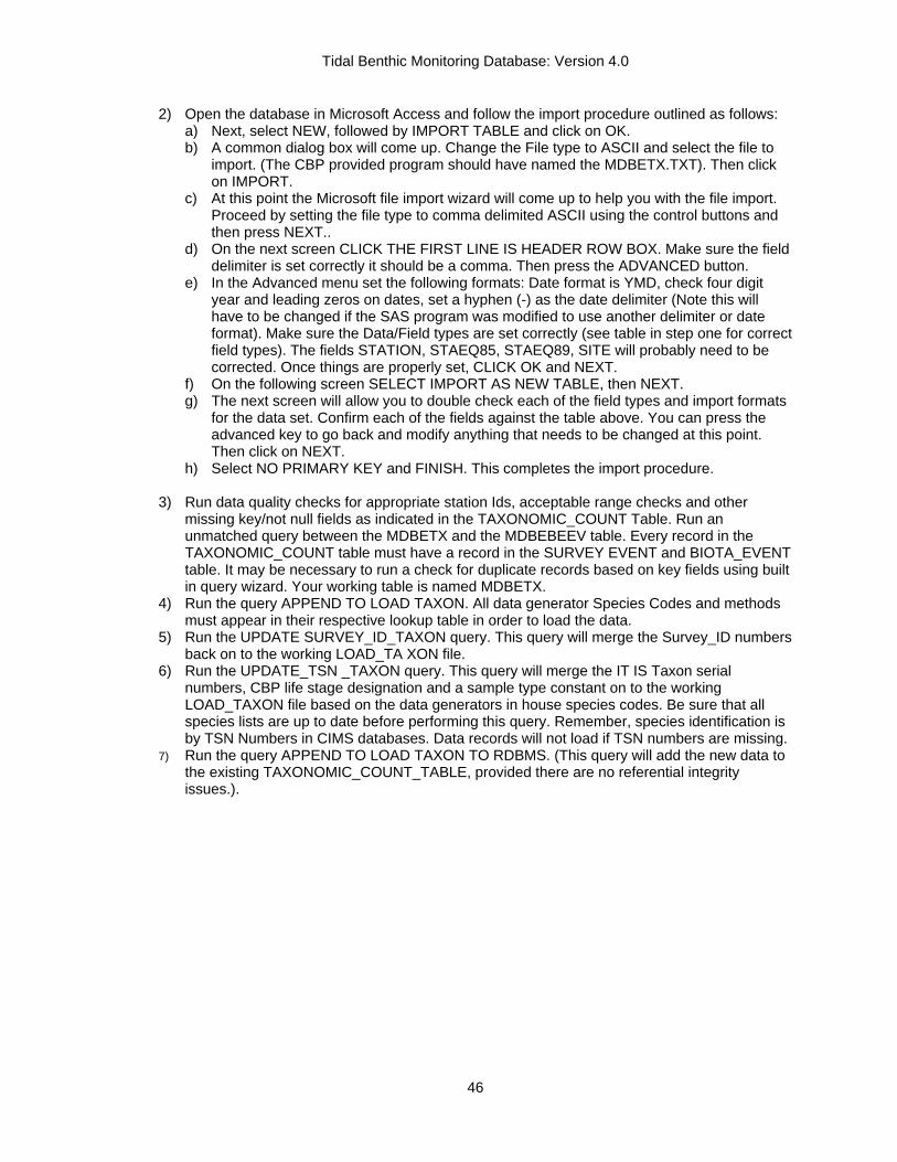
Tidal Benthic Monitoring Database: Version 4.0
46
2) Open the database in Microsoft Access and follow the import procedure outlined as follows: a) Next, select NEW, followed by IMPORT TABLE and click on OK. b) A common dialog box will come up. Change the File type to ASCII and select the file to
import. (The CBP provided program should have named the MDBETX.TXT). Then click on IMPORT.
c) At this point the Microsoft file import wizard will come up to help you with the file import. Proceed by setting the file type to comma delimited ASCII using the control buttons and then press NEXT..
d) On the next screen CLICK THE FIRST LINE IS HEADER ROW BOX. Make sure the field delimiter is set correctly it should be a comma. Then press the ADVANCED button.
e) In the Advanced menu set the following formats: Date format is YMD, check four digit year and leading zeros on dates, set a hyphen (-) as the date delimiter (Note this will have to be changed if the SAS program was modified to use another delimiter or date format). Make sure the Data/Field types are set correctly (see table in step one for correct field types). The fields STATION, STAEQ85, STAEQ89, SITE will probably need to be corrected. Once things are properly set, CLICK OK and NEXT.
f) On the following screen SELECT IMPORT AS NEW TABLE, then NEXT. g) The next screen will allow you to double check each of the field types and import formats
for the data set. Confirm each of the fields against the table above. You can press the advanced key to go back and modify anything that needs to be changed at this point. Then click on NEXT.
h) Select NO PRIMARY KEY and FINISH. This completes the import procedure.
3) Run data quality checks for appropriate station Ids, acceptable range checks and other missing key/not null fields as indicated in the TAXONOMIC_COUNT Table. Run an unmatched query between the MDBETX and the MDBEBEEV table. Every record in the TAXONOMIC_COUNT table must have a record in the SURVEY EVENT and BIOTA_EVENT table. It may be necessary to run a check for duplicate records based on key fields using built in query wizard. Your working table is named MDBETX.
4) Run the query APPEND TO LOAD TAXON. All data generator Species Codes and methods must appear in their respective lookup table in order to load the data.
5) Run the UPDATE SURVEY_ID_TAXON query. This query will merge the Survey_ID numbers back on to the working LOAD_TA XON file.
6) Run the UPDATE_TSN _TAXON query. This query will merge the IT IS Taxon serial numbers, CBP life stage designation and a sample type constant on to the working LOAD_TAXON file based on the data generators in house species codes. Be sure that all species lists are up to date before performing this query. Remember, species identification is by TSN Numbers in CIMS databases. Data records will not load if TSN numbers are missing.
7) Run the query APPEND TO LOAD TAXON TO RDBMS. (This query will add the new data to the existing TAXONOMIC_COUNT_TABLE, provided there are no referential integrity issues.).
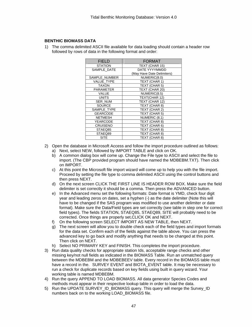
Tidal Benthic Monitoring Database: Version 4.0
47
BENTHIC BIOMASS DATA 1) The comma delimited ASCII file available for data loading should contain a header row
followed by rows of data in the following format and order:
FIELD FORMAT STATION TEXT (CHAR 15)
SAMPLE_DATE DATE YYYYMMDD (May Have Date Delimiters)
SAMPLE_NUMBER NUMERIC(8.0) VALUE_TYPE TEXT (CHAR 1)
TAXON TEXT (CHAR 5) PARAMETER TEXT (CHAR 20)
VALUE NUMERIC(8.5) UNITS TEXT(CHAR 12)
SER_NUM TEXT (CHAR 12) SOURCE TEXT (CHAR 8)
SAMPLE_TYPE TEXT (CHAR 2) GEARCODE TEXT (CHAR 5) NETMESH NUMERIC (8.1)
YEARCODE TEXT (CHAR 8) CRUISENO TEXT (CHAR 6) STAEQ85 TEXT (CHAR 8) STAEQ89 TEXT (CHAR 8)
SITE TEXT (CHAR 8) 2) Open the database in Microsoft Access and follow the import procedure outlined as follows:
a) Next, select NEW, followed by IMPORT TABLE and click on OK. b) A common dialog box will come up. Change the File type to ASCII and select the file to
import. (The CBP provided program should have named the MDBEBM.TXT). Then click on IMPORT.
c) At this point the Microsoft file import wizard will come up to help you with the file import. Proceed by setting the file type to comma delimited ASCII using the control buttons and then press NEXT.
d) On the next screen CLICK THE FIRST LINE IS HEADER ROW BOX. Make sure the field delimiter is set correctly it should be a comma. Then press the ADVANCED button.
e) In the Advanced menu set the following formats: Date format is YMD, check four digit year and leading zeros on dates, set a hyphen (-) as the date delimiter (Note this will have to be changed if the SAS program was modified to use another delimiter or date format). Make sure the Data/Field types are set correctly (see table in step one for correct field types). The fields STATION, STAEQ85, STAEQ89, SITE will probably need to be corrected. Once things are properly set,CLICK OK and NEXT.
f) On the following screen SELECT IMPORT AS NEW TABLE, then NEXT. g) The next screen will allow you to double check each of the field types and import formats
for the data set. Confirm each of the fields against the table above. You can press the advanced key to go back and modify anything that needs to be changed at this point. Then click on NEXT.
h) Select NO PRIMARY KEY and FINISH. This completes the import procedure. 3) Run data quality checks for appropriate station Ids, acceptable range checks and other
missing key/not null fields as indicated in the BIOMASS Table. Run an unmatched query between the MDBEBM and the MDBEBEEV table. Every record in the BIOMASS table must have a record in the. SURVEY EVENT and BIOTA_EVENT table. It may be necessary to run a check for duplicate records based on key fields using built in query wizard. Your working table is named MDBEBM.
4) Run the query APPEND TO LOAD BIOMASS. All data generator Species Codes and methods must appear in their respective lookup table in order to load the data.
5) Run the UPDATE SURVEY_ID_BIOMASS query. This query will merge the Survey_ID numbers back on to the working LOAD_BIOMASS file.

Tidal Benthic Monitoring Database: Version 4.0
48
6) Run the UPDATE_TSN _BIOMASS query. This query will merge the IT IS Taxon serial numbers, CBP life stage designation and a sample type constant on to the working LOAD_BIOMASS file based on the data generators in house species codes. Be sure that all species lists are up to date before performing this query. Remember, species identification is by TSN Numbers in CIMS databases. Data records will not load if TSN numbers are missing.
7) Run the query APPEND TO LOAD BIOMASSTO RDBMS. (This query will add the new data to the existing BIOMASS_TABLE, provided there are no referential integrity issues.)
BENTHIC INDEX OF BIOTIC INTEGRITY DATA Beginning in January 2005, the data providers submitted calculated Benthic Index of Biotic
Integrity indices. IBI Metrics (developed by Weisberg et.al. (1997), modified by Alden et.al. (2002)) are calculated using the protocol described in the document Methods for Calculating the Chesapeake Bay Benthic Index of Biotic Integrity This index data is currently caculated by the data generators using the protocol : http://www.esm.versar.com/Vcb/Benthos/docs/ChesBayBIBI.PDF.
1) The comma delimited ASCII file available for data loading should contain a header row followed by rows of data in the following format and order:
FIELD FORMAT
STATION TEXT(CHAR 15) SAMPLE_DATE DATE YYYYMMDD
(May Have Date Delimiters) SAMPLE_NUMBER NUMERIC(8.0) IBI_PARAMETER TEXT (15)
VALUE NUMERIC(8.4) SCORE NUMERIC(8.2)
IBI_SALZONE TEXT(CHAR 15) IBI_BOTTOM_TYPE TEXT(CHAR 15)
R_DATE DATE YYYYMMDD (May Have Date Delimiters)
2) Open the database in Microsoft Access and follow the import procedure outlined as follows:
a) Next, select NEW, followed by IMPORT TABLE and click on OK. b) A common dialog box will come up. Change the File type to ASCII and select the file
to import. (The CBP provided program should have named the MDBEIBI.TXT). Then click on IMPORT.
c) At this point the Microsoft file import wizard will come up to help you with the file import. Proceed by setting the file type to comma delimited ASCII using the control buttons and then press NEXT.
d) On the next screen CLICK THE FIRST LINE IS HEADER ROW BOX. Make sure the field delimiter is set correctly it should be a comma. Then press the ADVANCED button.
e) In the Advanced menu the select the import template specific for the data provider laboratory (VERSAR or ODU) and data type (IBI). Check to make sure the following formats are correct: Date format is YMD, check four digit year and leading zeros on dates, set a hyphen (-) as the date delimiter (Note this will have to be changed if the SAS program was modified to use another delimiter or date format). Make sure the Data/Field types are set correctly (see table in step one for correct field types). CLICK OK and NEXT.

Tidal Benthic Monitoring Database: Version 4.0
49
f) Run data quality checks for appropriate station Ids, value range checks and other missing key/not null fields as indicated in the TAB_IBI_METRICS Table. Run an unmatched query between the MDBEWQ and the MDBEEV table. Every record in the WATER_QUALITY table must have a record in the EVENT table. All water quality parameter names and methods must appear in their. respective lookup table in order to load the data. It may be necessary to run a check for duplicate records based on key fields using built in query wizard. Your working table is named MDBEIBI.
3) Run of data range checks are performed on the IBI_Parameter Values ranges found in the
TAB_IBI_PARAMETER. If data values are found to not meet accepted data ranges shown in table 18 and do not have explanatory documentation from the laboratory, data are returned to the data provider for correction or minimally written explanation of problem.
4) A series of overall QA QC routines are run over the data. These checks include: Queries to
look for duplicate records. If a station had biological data sampled and enumerated during a reporting period, were IBI data calculated for each sample replicate. If errors are found, data is returned to the data provider for correction or documentation.
5) Append the working file to LOAD_IBI Table Template. 6) Run the query APPEND TO LOAD IBI. Run the UPDATE EVENT_ID_IBI query. This query will merge the EVENT_ID numbers back on to the working IBI file.Run the query APPEND TO LOAD IBI TO RDBMS. (This query will add the new data to the existing TAB_IBI_METRICS, provided there are no referential integrity issues.)

50
THE ENTITY RELATIONSHIP DIAGRAM
Note Major Tables Only

51