tinker preserve management plan - yarmouth, maine27541806-6670-456d-9204...management decision that...
TRANSCRIPT

1
Tinker Preserve Management Plan
2017
In memory of Steward and Contributor David Adams
with support from Yarmouth Parks & Lands Committee Members
and Town of Yarmouth Staff

2
Table of Contents
1. Executive Summary
a. Statement
b. Location map
c. Aerial image
2. Description and History
a. Description
b. Land use history
c. Parcel acquisitions
d. Deed restrictions
e. Stakeholders
3. Resource Inventory
a. Natural resources
i. Geology & soils
ii. Topography and hydrology
iii. Vegetation
iv. Habitat/Wildlife
b. Cultural resources
c. Recreational resources
i. Public access
ii. Trails
iii. Active recreation
iv. Scenic vistas
v. Amenities
4. Park and Land Use
a. Current use
b. Allowable use
c. Restricted use
d. Conflicting use
e. Potential and/or recommended use
5. Management
a. Guiding summary of management goals and strategies
i. Vegetation and invasive species
ii. Trails/Recreation
iii. Habitat
iv. Scenic vistas
6. Implementations and Recommendations
7. Appendices

3
1. Executive Summary
1.a. Statement
In 1970 Katherine Prescott Tinker donated this 15.4 acre property on Cousins Island to The Nature Conservancy
(TNC) who, in turn, donated the fee-simple to the Town of Yarmouth subject to deed restrictions. The
dominant conservation goals include education, conservation and wildlife habitat preserve. The Protected
Property is the site of a farm that dates from the mid 1700’s. After the original grantors life tenancy expired, the
farm house and barns were removed and the property was “…left as a relatively natural area to be used by
individuals and groups, such as schools and youth and adult organizations.”
The Property is bisected by Seal Lane, within the Right-of-Way defined in an easement.
Significant physical features of the Protected Property include ½ mile of trails, small parking lot off Seal Lane,
a cemetery, remnants of the former home and farm site, stone walls, and a memorial plaque to the original
grantor of the conservation values of this property to the public. Ground cover is 90% mixed mature hardwood
and white pine forest and 10% open field. The open field feels dominant to the user because of this proximity to
the road and the location throughout the middle of the property. Despite its small area being surrounded by the
present island suburb, it offers a surprising and welcoming experience, increasingly rare, of rural solitude.
The meadow areas are mowed monthly during the growing season to encourage native plant to replace the
recently dominant Asiatic bittersweet. Modifying the property to conform to a desired educational use shall be
subject to the discretion of the “Superintending School Committee” of the town of Yarmouth.
1.b. Location Map
Katherine P. Tinker Preserve

4
1.c. Aerial Image
2. Description and History
2.a. Property Description
This 15.4 acre parcel of land located on Cousins Island is a natural resource asset to the town and of particular
value to the residents of the Cousins and Little John Islands. Consistent with the deeded intention of a
‘sanctuary to protect and preserve plant and animal species,’ the property offers natural beauty that residents
frequently enjoy while walking, jogging, hiking, picnicking, or snowshoeing.
The majority of the property is on level terrain, with a small portion of a moderately steep slope on the
southwest corner of the lot. The soil here is a deep, well-drained gravelly sandy loam, formed as water-sorted
material. A small dirt road provides access into the property from Cousins Road.
5
The terrain and soil of this property supports various woody shrubs and dominant tree species of pines, oaks,
and some poplars. Some old apple trees persist from the days when a home was located on the property, which
adds an aesthetic feature. Some invasive species of vegetation have established themselves, specifically
staghorn sumac and bittersweet. The bittersweet began dominating the other plant species, and following the
removal by a contracted company, it is now being managed by the town. Although a native species, it is a
management decision that the town also clears the sumac.
The protected and vegetated property offers a safe and abundant habitat for various small animals, such as
squirrels, raccoons, and chipmunks, some larger animals such as deer, and many bird species.
Centrally located on Cousins Island and accessible from the main street on the island, the property is amid a
residential area.
The property is subject to certain prior conveyances including a 50 foot right-of-way in common (Seal Lane) to
lot owners (currently 4) at the northwesterly end of the property. There are also utility easements granted to
CMP and the Yarmouth Water District which cross the property.
There is a small cemetery on the easterly bound of the property which is maintained by the Cousins Island
Cemetery Association. It has not been determined if that cemetery was separately and previously conveyed to
the Town and/or the Cemetery Association or if it is merely a feature of the Tinker parcel.
2.b. Land Use History
In 1780, Daniel Drinkwater lived in a home in the approximate location of the current remnant foundation. It
was subsequently occupied by descendants, followed by William Weeks, Eleazer and Hannah Hill, and as late
as 1890 Elizer Hill in her 80’s from “Cousins and Littlejohn Islands 1645-1893” by Katherine Prescott Kaster
[Tinker].
Dr. Katherine Prescott (Kaster) Tinker (1901-1980) grew up summering on Littlejohn Island where she married
her second husband, a soldier stationed on Cousins Island and who was subsequently killed during WWII. She
acquired the property from Raymond Talbot in 1946 but sold off much of the bordering lots over the years.
She was a professor of astronomy at Vassar College in New York. Island legend is that she lived in the house
in her later years but when it deteriorated she moved to the barn. Her writings and records filled the structures
but were largely lost upon her death.
Tinker Preserve has long been a favorite place for walking and quiet contemplation for Cousins Island residents,
particularly for dogs and their owners. There is now a well-worn trail around its entire perimeter as well as the
inviting rural character of Seal Lane.
During the last quarter of the 20th Century a very thick infestation of Oriental Bittersweet invaded the entire
Preserve, both its cleared portions and its forests. By 2004, a substantial portion of the trees were in the process
of being dragged down and choked to death while the grass lands were in large part completely replaced by this
scourge. Since then an aggressive eradication program has been carried out annually under the direction of
Yarmouth’s Parks and Lands Committee through citizen volunteer work days particularly by school groups and
island residents and through annual Yarmouth Community Services budgets for contract cutting and bush
hogging. The results have been quite successful (see before and after comparison photos from 2004 and 2009).

6
2.c. Parcel Acquisitions
This conservation parcel was acquired in a single phase. The parcel boundary and area (15.4±ac) remains
unchanged from the transfer from Katherine Prescott Tinker to The Nature Conservancy and subsequently to
the Town of Yarmouth.
2.d. Deed Restrictions
The fee-simple ownership of the Preserve is held by the Town of Yarmouth donated by The Nature
Conservancy via Quit-Claim Deed (CCRD3129/11) subject to deed restrictions including a clause restoring fee
ownership to The Nature Conservancy should use of the parcel conflict with the terms of the conservation goals.
In 1970, Dr. Tinker conveyed the current acreage to The Nature Conservancy which after conveying it to the
Town with the following conservation restrictions (portions of the deed quoted here in part)—the property “may
be left as a relatively natural area to be used by individuals and groups, such as schools and youth and adult
organizations…for:
1. Scientific research in ecology and related fields;
2. Conservation and environmental management activities and experiments, including outdoor classes,
field trips, and investigations;
3. A sanctuary to protect and preserve plant and animal species.”

7
“The described uses shall be subject to the discretion of the super-intending School Committee of the Town of
Yarmouth so long as the title to said property remains in the inhabitants of the Town of Yarmouth…This
conveyance is made subject to the express condition and limitation that the premises conveyed shall forever be
held for the uses here in set forth, and a breach there of shall cause title…to revert to the…Grantor” (The Nature
Conservancy).
2.e. Stakeholders
• Town of Yarmouth; fee-simple holder, routine mechanical maintenance
• The Nature Conservancy; deed restriction enforcement
• Town of Yarmouth School Committee; may authorize and approve educational, conservation and
environmental activities
• Volunteer Stewards; monitoring, maintenance
3. Resource Inventory
3.a. Natural Resources
i. Geology & Soils
Appendix B depicts the soils limitations of the Property, showing a rough approximation of the six (6) soil
types found. They are as follows:
• Paxton fine sandy loam
• Scantic silt loam
• Hinckley gravely sandy loam
• Walpole fine sandy loam
• Swanton fine sandy loam
• Deerfield loamy sand
ii. Topography and Hydrology
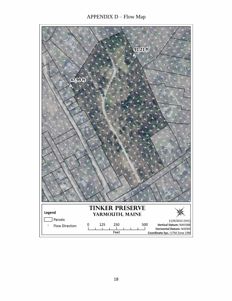
Tinker Preserve straddles the main ridge that runs along the north-south axis of Cousins Island. The high
point within the Preserve measures 91 feet NAVD88 and is located near the northern property boundary
where a well-established trail exits the property. From this location, very low rolling hills, swales, and
terraces radiate away to the northeast, east, southeast, and south with slopes rarely exceeding 5%. The land
descends more steeply to the southwest, with slopes exceeding 10% in several areas. The low point of the
Preserve measures 48 feet and is located at the southwestern corner of the property on the steep, southwest-
facing slope. A perimeter trail begins at 74 feet elevation at the parking area and climbs over two terraces
before reaching the summit of the property and dropping quickly to a low elevation of 57 feet whereupon
the trail climbs back to the parking area. A topographical map is available in Appendix C.

8
Figure 1. 3D rendition of Tinker Preserve with the perimeter trail shown in red and the parking area indicated by the
yellow arrow.
Figure 2. Profile of perimeter trail starting and ending at the parking area and following a counter-clockwise direction.
Tinker Preserve is a headwater with very little evidence of overland flow through natural channel networks on
the actual property. Seal Lane and the four driveways it services create localized topographic breaklines that
serve to route overland runoff through constructed ditches and other conveyances. The majority of the soil units
on the property are sandy loams and drain well, but the soils along the northern and eastern boundaries are finer
and drain poorly. Higher soil water content is evident in areas where these poorly drained soils coincide with
topographic convergences. A flow map is available in Appendix D.
iii. Vegetation
Vegetation is described as trees and shrubs of apple, chokecherry, and juniper; stands of aspen, white pine,
American ash, balsam fir, beech, grey birch, red maple, red oak, and white birch. Previously logged areas
host native grasses, goldenrod, Queen Anne’s Lace, steeplebush, wild rose, wild raspberry, staghorn,
sumac, shadbush, willow, spirea, bayberry, and rare concentrations of milkweed. A large dense patch of
day lilies, and occasional asparagus are remnants of gardening in the past century.
iv. Habitat/Wildlife Animal inhabitants shared with the rest of Cousins Island are squirrels, chipmunks, a rare porcupine,
raccoons, foxes, and deer. Bird life includes wild turkeys, crows, blue jays, woodpeckers, gulls, mourning
doves, cardinals, hummingbirds, and many native smaller birds. Raptors include Coopers and sharp-

9
shinned hawks, ospreys, and bald eagles. There are no occupied raptor nests to be seen currently.
Monarch butterflies enjoy the milkweed patches.
3.b. Cultural Resources
At this time, there is no information known about the Tinker Preserve parcel that might be of significant interest
to archeological or historical resources.
3.c. Recreational Resources
The recreational resources of the Preserve are a combination of low impact passive use, consisting primarily of
walking the trail and road, with enjoyment of the beauty of the varying habitat.
i. Public Access
Public access to the Tinker Preserve is primarily via Cousins Street to Seal Lane. A small parking lot is
situated on Seal Lane approximately 50 yards from the entrance to the Preserve.
ii. Trails
The property has approximately ½ mile loops of trails throughout the property. Trail access can be found
from Seal Lane and the small parking area.
iii. Active Recreation
Active recreation is limited to use of the trails and roadway. There are no ball fields or additional
scheduled activities at this site. The park’s roadway and trails are used primarily by neighboring residents
for morning walks with their dogs. As with many open spaces, the Town of Yarmouth’s Municipal Code,
Chapter 309: Dog Control Ordinance “provide[s] regulations in addition to those contained in Title 7,
M.R.S.A. with respect to controlling dogs throughout the Town of Yarmouth in the interest of the health,
safety and general welfare of its residents.”
Bicycle traffic and through uses by bicycles are discouraged, as transportation to additional areas on
Cousins Island may be accessed via the paved safety path alongside Cousins Street.
iv. Scenic Vistas Small open fields bounded by established oak wood lots provide a limited vista. A cemetery, remnant of
the former home and farm site, stone walls, and a memorial plaque to the original grantor of the
conservation values of this property to the public. There is no water access or views from this landlocked
property.
v. Amenities In 2016, a Story Walk was completed by a Yarmouth Eagle Scout featuring page-like signs for
environmental and recreational exploration.
4. Park and Land Use
4.a. Current use
A multi-use, wooded trail (± 1km) near north property boundary, from the Seal Lane parking area to the
cemetery near the (N/F) Drinkwater boundary is maintained by volunteers and neighbors. The Tinker Property
trail sees light, low-impact recreational use often including bird watching, natural observation, and dog walking.

10
The dominant user group seems to be the Cousins Island community who access the preserve by foot. The
Town discourages public use of any private properties that are adjacent to Tinker Property.
4.b. Allowable Use
The Tinker Preserve was conveyed to be left as a relatively natural area and to be used by individuals and
groups such as schools and youth and adult organizations, and providing specifically for:
1. Scientific research in ecology and related fields;
2. Conservation and environmental management activities and experiments, including the development
and manipulation of demonstration areas and habitats such as ponds, fields, etc;
3. Conservation and environmental education learning experiences, including outdoor classes, field
trips, and investigations.
4. A sanctuary to protect and preserve plant and animal species.
The uses described in Doc. 8041 shall be subject to the discretion of the Superintending School Committee of
the Town of Yarmouth so long as the title to said property remains in the Inhabitants of the Town of Yarmouth.
4.c. Restricted Use
Use of this property is prohibited for uses not identified in the deed.
4.d. Conflicting Use
As of late 2015, there is low impact pedestrian and bicycle recreational use, residential and associated traffic
along Seal Lane, active invasive upland plant management, and meadow management allowing for growth of
milkweed as habitat. The Parks and Lands Committee will continue to discourage bicycle use on trails within
the property boundaries at Tinker Preserve.
4.e. Potential and/or Recommended Use
Some municipal uses such as a community garden or outdoor education center are possible, but otherwise the
property has very limited development potential.
5. Management
5.a. Guiding Summary of Management Goals and Strategies
Although the USDA report suggested the potential creation of two small fresh water ponds, no similar large
scale revisions to the Preserve are being contemplated—the rationale being that the present facility serves the
citizens of Yarmouth very well. Certainly the current program of aggressive bittersweet suppression will
continue to be of critical importance. A very localized application of the herbicide, Glyphosate, to the parts of
the stone wall and building foundation within the field has had lasting effectiveness but will probably need to be
repeated every few years. Its only application was in 2011 when it was realized that pulling and cutting was not
effective for bittersweet protected deep within the wall and foundation.
While connectivity is a goal at all the open spaces within Yarmouth, this property is currently land-locked by
private abutters. Discussions and future opportunities may be brought to the Parks and Lands Committee as
land owners change or when additional conversations allow for partnerships, easements, or ownership of
contiguous lands.

11
Finally, as the deeds from Dr. Tinker and The Nature Conservancy state, the guiding principle for what the
Tinker Preserve should be in the future, as in the past, is that it be left as much as possible in its natural state.
This was the conclusion of a 2004 questionnaire of Cousins Island and Littlejohn Island Association members,
though a few responses favored creation of a community garden. In 2001 and again in 2008 paving of Seal
Lane was proposed but abandoned in the face of opposition to this perceived move away from a natural state
concept.
i.Vegetation and Invasive Species
Biodiversity through management of dominant invasive species compliment the goal of creating habitat
edges between meadow and forest.
ii.Trails/Recreation:
Trails are allowed and may be framed in the context of recreational
access or scientific exploration and education. (Please see insert at
right.)
iii.Habitat
The deed allows for the construction of ponds to develop habitat and/or
for scientific endeavors.
iv.Scenic Vistas
The open meadow allows for short vistas horizontal to the ground,
creating opportunities for wildlife observation. The limited
topographical relief of this protected property does not create the
opportunity for long vistas or horizon views.
6. Implementations and Recommendations
• This property is protected in perpetuity by a deed with restrictions from the grantor The Nature Conservancy
to the Town of Yarmouth (CCRD 3129/11). TNC or a volunteer steward should continue to monitor and report
on their findings of that visit annually. A copy of these monitoring reports should be circulated to the Town.
• Prepare and maintain a photographic record of the extent of invasive species infestation and document and
map the methods used and results from various control efforts, updated at least annually, to provide a historical
basis for assessing effectiveness of control efforts.
• Designate/recruit a Tinker Preserve Steward. Parks & Lands Committee member and Cousins Island resident,
David Adams volunteered for many years to support this property along with current Cousins Island resident,
Bill Hoffman.
• Identify specific projects and organize seasonal work parties, taking advantage of volunteer labor, such as
“friends” of the Preserve, Scouts, Yarmouth High School service volunteers, civic organizations, etc, as
appropriate and needed.
• Identify additional signage to address concerns or problems that arise in the future regarding property use or
illegal activities. Be alert to possible future acquisitions and/or additions to the Preserve, noting any

12
conclusions or observations as part of the annual reports to the Parks and Lands Committee. These could be for
varying purposes.
• Promoting new or additional goals or values – none identified at this time.
• Enhancing existing values – an example is the addition of the Story Walk along the trail within the Preserve,
which provides an educational component at Tinker Preserve.

13
7. Appendices APPENDIX A – Cumberland County Registry of Deeds Book 3129 / Page 11

14

15

16
APPENDIX B – Soils Map

17
APPENDIX C – Elevation Map
18
APPENDIX D – Flow Map