title 17: zoning - planning, administration, fees, …-+title+17+zoning.pdf · title 17: zoning...
TRANSCRIPT
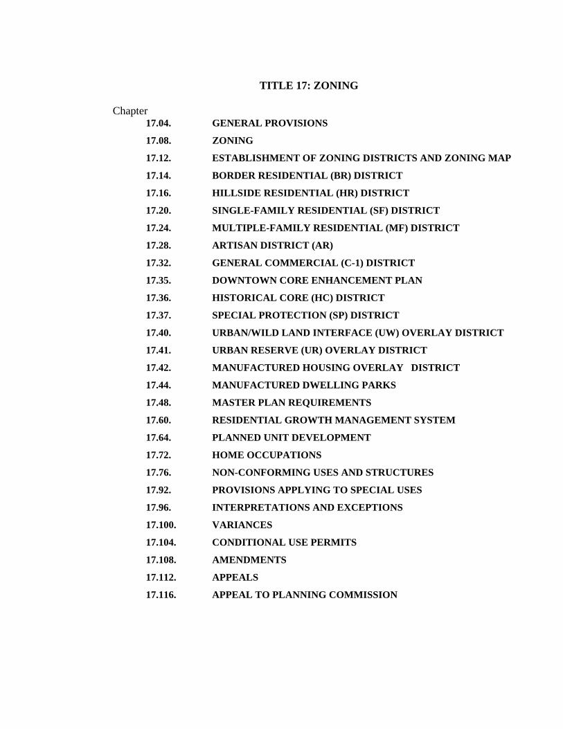
TITLE 17: ZONING
Chapter 17.04. GENERAL PROVISIONS
17.08. ZONING
17.12. ESTABLISHMENT OF ZONING DISTRICTS AND ZONING MAP
17.14. BORDER RESIDENTIAL (BR) DISTRICT
17.16. HILLSIDE RESIDENTIAL (HR) DISTRICT
17.20. SINGLE-FAMILY RESIDENTIAL (SF) DISTRICT
17.24. MULTIPLE-FAMILY RESIDENTIAL (MF) DISTRICT
17.28. ARTISAN DISTRICT (AR)
17.32. GENERAL COMMERCIAL (C-1) DISTRICT
17.35. DOWNTOWN CORE ENHANCEMENT PLAN
17.36. HISTORICAL CORE (HC) DISTRICT
17.37. SPECIAL PROTECTION (SP) DISTRICT
17.40. URBAN/WILD LAND INTERFACE (UW) OVERLAY DISTRICT
17.41. URBAN RESERVE (UR) OVERLAY DISTRICT
17.42. MANUFACTURED HOUSING OVERLAY DISTRICT
17.44. MANUFACTURED DWELLING PARKS
17.48. MASTER PLAN REQUIREMENTS
17.60. RESIDENTIAL GROWTH MANAGEMENT SYSTEM
17.64. PLANNED UNIT DEVELOPMENT
17.72. HOME OCCUPATIONS
17.76. NON-CONFORMING USES AND STRUCTURES
17.92. PROVISIONS APPLYING TO SPECIAL USES
17.96. INTERPRETATIONS AND EXCEPTIONS
17.100. VARIANCES
17.104. CONDITIONAL USE PERMITS
17.108. AMENDMENTS
17.112. APPEALS
17.116. APPEAL TO PLANNING COMMISSION

2
CHAPTER 17.04: GENERAL PROVISIONS
Section
17.04.010 Planning Commission established 17.04.020 Planning Commission interpretations
§ 17.04.010 PLANNING COMMISSION ESTABLISHED. A planning commission is hereby established to be constituted and have the powers and duties as set forth in ORS 227.010 to 227.150, which is adopted by reference and made a part of this section together with all amendments which now or hereafter may be enacted thereto. § 17.04.020 PLANNING COMMISSION INTERPRETATIONS. In applications where the Unified Development Code is unclear or subject to multiple interpretations, the planning commission is hereby authorized and empowered to render a definitive interpretation of the Unified Development Code buy majority vote. Such an interpretation must then be applied consistently to all subsequent applications. (ORD. 547, passed 5-17-2005)

3
CHAPTER 17.08: ZONING
Section
17.08.010 Repeal of ordinances 17.08.020 Title 17.08.030 Purpose 17.08.040 Enactment and effect 17.08.050 Compliance with title provisions 17.08.060 Definitions for uses 17.08.070 Authorization of Similar Uses
§ 17.08.010 REPEAL OF ORDINANCES. [Repealed--Zoning Ordinance #90 (and subsequent amendments thereto), Ordinance #93, Ordinance #121, Ordinance #168, Ordinance #169, Ordinance #171, Ordinance #173, and Ordinance #182; and amending parts of Ordinance 281 §II(part), 1982 and Ordinance455 (part), 1996, of the city of Jacksonville, Oregon, dated this 5th day of March, 2002]. § 17.08.020 TITLE. This document and its provisions are the Zoning Regulations of the City of Jacksonville and are part of the larger "Unified Development Code." § 17.08.030 PURPOSE. The purpose of this title is to classify, designate, and regulate the location and use of buildings, structures and land for residential, commercial, industrial or other uses in appropriate places and for said purpose to divide the city into districts of such number, shape and area as may be deemed best suited to carry out these regulations and provide for their enforcement; to encourage the most appropriate use of land; to conserve and stabilize the value of property; to provide adequate open spaces for light and air and prevention of fires; to prevent undue concentrations of population; to lessen congestion of streets; to facilitate adequate provisions for community utilities such as transportation, water, sewer, schools, parks, and other public requirements; and in general to promote the health, safety and welfare of the citizens and visitors of Jacksonville; all of which are in accordance with and in implementation of the comprehensive plan of the city. § 17.08.040 ENACTMENT AND EFFECT. This title is enacted and placed into effect as a result of its adoption by the city council of Jacksonville the 19th day of October, 1982. 17.08.050 COMPLIANCE WITH TITLE PROVISIONS.

4
No buildings or other structures shall be constructed, improved or altered, enlarged or moved, nor shall any use or occupancy of premises within the city be commenced or changed, nor shall any condition of or upon real property be caused or maintained, after the effective date of the ordinance codified in this title, except in conformity with conditions prescribed for each of the several zones established hereunder. It shall be unlawful for any person, firm or corporation to erect, construct, establish, move into, alter, enlarge or use, or cause to be used, any building, structure, improvement or use of premises located in any zone described in this title contrary to the provisions of this title. Where this title imposes greater restrictions than those imposed or required by other rules or regulations or ordinances, the provisions of this title shall control. § 17.08.060 DEFINITIONS FOR USES. Definitions for Uses:
1. Residential.
(a) Single-family
SINGLE-FAMILY: A single-family detached dwelling. This category shall also include manufactured homes not located in a mobile home park and detached homes in self-contained parks or villages (including those for senior citizens). Boarding houses, rooming houses, etc. with five (5) or fewer bedrooms shall be considered to be a SFR. If any of the rooms have kitchen facilities, then they shall be considered to be a separate dwelling unit and shall be charged under the "multi-family" category. If the building or facility contains more than five (5) bedrooms, then it shall be charged under the "Hotel/Motel" category.
(b) Multi-family
REGULAR: A building that is divided into more than one dwelling unit for the purpose of renting or single-family ownership (such as condominiums). Mobile home parks shall be included in this category. Facilities may include recreation rooms, swimming pools and laundry facilities. These facilities shall not be categorized separately unless they are used primarily by persons other than those who reside in the mobile home park, or apartment/ condo/ townhouse complex. BOARDING, LODGING, ROOMING HOUSES, ETC: with five (5) or fewer bedrooms shall be classified as SFRs; if more than five (5) bedrooms, they shall be classified under "Hotel/Motel". If rooms contain kitchen facilities, then they shall be considered "Multi-family". SENIOR HOUSING FACILITY: A facility that will be eighty-five percent (85%) occupied by persons fifty-five (55) years of age or older and which contains residential units similar to apartments or condominiums, and may be self-contained villages. They may contain special services such as medical facilities, dining facilities and some limited supporting retail facilities.

5
This category would include, but not be limited to, retirement communities, congregate care facilities and elderly housing (attached). Although each of these may include medical abilities, the intent of this category is to include only those housing facilities considered to be providing independent living for the elderly. Detached elderly housing shall be considered to be in the Single-family category. (2) Commercial. (a) Truck/Bus Terminal TRUCK TERMINAL: A truck terminal is where goods are transferred between trucks, trucks and railroads, or trucks and ports, and includes all maintenance and office facilities and all land used by a commercial transportation company. A bus terminal includes all passenger loading and/or maintenance and storage areas used by a commercial bus company. TRUCKS: The focus of the ITE Manual's definition is the transfer of goods. It is not a facility whose primary use is by the general public. It serves primarily as a business-to-business carrier. BUS TERMINAL: includes the entire improved area of a commercial bus company's facility that is used for passenger loading and/or maintenance and storage areas.
(b) Retail This category includes such business establishments as those selling building materials, hardware, garden supply, mobile home dealers, general merchandise stores, food stores, car dealers, gas stations, apparel and accessory stores, eating and drinking places, and miscellaneous retail as outlined in the 1987 edition of the Standard Industrial Classification Manual. This category is intended to cover establishments which are primarily engaged in selling merchandise for personal or household consumption and rendering services which are incidental to the sale of the goods. Some of the important characteristics of Retail establishments include engaging in activities to attract the general public to buy; they may process their products, but such processing is incidental or subordinate to selling, they sell to customers for personal or household use. The exceptions to the general rule of selling to the general public for personal or household use are lumber yards, paint, glass, and wallpaper stores; typewriter stores, stationery stores, and gasoline service stations. These are classified as Retail by the SIC manual and can be sold to both the general public and to businesses. However, establishments which sell products only to institutional or industrial users and to other wholesalers and establishments that sell similar merchandise for use exclusively by business establishments should be considered to be wholesale activities. Such establishments will be classified under the "Other Commercial/ Industrial" category. Establishments primarily engaged in selling such merchandise as plumbing equipment, electrical supplies, used automobile parts, and office furniture shall be classified as "Retail" if the higher proportions of their customers are the general public. This rule is contrary to the statement in the Retail section of the SIC manual. Establishments at which sales people are based, but who do their selling through visitations to the general public at other sites, shall be classified as "Retail". If these sales are to institutions,

6
retailers, contractors, or other businesses, then they shall be considered to be a wholesale activity and shall be classified under "Other Commercial/Industrial". Processing that is incidental or subordinate to selling often is conducted at retail establishments. For example, restaurants prepare meals, meat markets cut meat, bakeries bake bread. Separate establishments which sell merchandise for personal or household consumption which has been manufactured or assembled by another establishment of the same company shall be classified as Retail. Anything classified under Division G (Retail) of the SIC manual shall be categorized as Retail. An exception is Industry No. 5961-Catalogue and Mail Order Houses. These shall be categorized under the "Other Commercial/Industrial" category. A facility which houses a business, the primary nature of which is to sell goods and which consists of a showroom or sales area, office, and a material supply or storage area for goods sold by said business, shall not be considered to be partially a warehouse. These material-supply, or stock areas, are to be considered as an integral part of the business and shall not constitute a basis for consideration as a separate category of use. This does not imply that a development or building cannot be classified under more than one Category-of-Use under other circumstances. (c) Services HOTEL/MOTEL: A commercial lodging facility providing sleeping accommodations to the general public. All establishments which fall under Industry No. 7011 of the SIC code manual shall be classified under this category. Restaurants or restaurant/lounges which are associated with these establishments and are open to the general public will be classified separately as "Retail".
BOARDING HOUSES, ROOMING HOUSES, ETC: consisting of six (6) or more bedrooms shall be classified here also. Bedrooms with kitchen facilities shall be considered separate dwelling units and shall be classified under "Multi-family".
PROFESSIONAL, PERSONAL AND REPAIR SERVICES: Establishments primarily engaged in providing a wide variety of services for individuals, businesses and government establishments, and other organizations. Services such as financial, insurance, real estate, engineering, accounting, research, management, legal, medical, repair, recreational and amusement services, except as specifically listed under other categories. It also includes museums, art galleries and utility customer service centers.

7
This category includes all those establishments listed in the SIC code manual under Division H (Finance, Insurance and Real Estate), Division I (Services), Major Group 07 (Agricultural Services) and Industry 4215 (Courier Services), except for the following:
7992 Public Golf Courses See Golf Course 8051 Skilled Housing Care Facilities See Health Serv. 8052 Intermediate Care Facilities See Health Serv. 8059 Nursing and Personal Care Fac's. See Health Serv. 806 Hospitals See Health Serv. 821 Elementary and Secondary Schools See Ed. Services 822 Colleges, Universities, Professional Schools and Junior Colleges See Ed. Services (Prof. Schools to remain as a "Prof. Service") 8351 Child Day Care See Ed. Services 8361 Residential Care See SFR, Multi-fam. or Hlth. Ser. 8399 Other Social Services See Non-Profit 8641 Fraternal Organizations Church/Fraternal See Non-Profit 8661 Religious Organizations See Non-Profit 7011 Hotels/Motels See Hotel/Motel
(d) Division H: Financial, Insurance and Real Estate Services. Finance includes depository institutions, non-depository credit institutions, holding companies, other investment companies, brokers and dealers in securities and commodity contracts. Insurance covers carriers of all types of insurance and insurance agents and brokers. Real Estate includes real estate operators (property management), real estate agents and managers, title companies and developers. (e) Division I: Services (General) This includes establishments providing personal, business, repair and amusement services; certain types of health services; legal, engineering and other professional services; certain kinds of educational services; membership organizations (except fraternal); and other miscellaneous services shall be included. Establishments which provide specialized services closely allied to, or incidental to, activities in other categories shall be included in those categories rather than Services. Customer service centers of utility companies shall be classified under "Professional Services". CEMETERY: A place for burying the dead, including accessory buildings used for funerals, mausoleum and crematorium.

8
AMUSEMENT AND RECREATION SERVICES: Generally, all amusement and recreation facilities except golf courses and public parks shall be placed under the "Professional Services" category. Seasonal outdoor recreational facilities such as miniature golf, go-carts, bumper boats, etc. shall be charged as a "Professional Service", using the gross square footage of the activity area (excluding parking but including any buildings). (f) Outdoor Recreation
(i) Golf Course - This category includes private country club and municipal golf courses. It does not include miniature golf courses. Included as accessory to the golf course shall be the putting green, pro shop, club house and lounge. Restaurant and banquet facilities shall be considered separately as "Retail". Driving ranges shall also be considered separately under "Professional Services".
(ii) Sports Park - An enclosed arena or stadium intended for sports activities. The entire area of each park shall be included in the category regardless of whether it is irrigated or not and regardless of the source of any irrigation water.
(g) Health Services
(i) Hospital - An institution where medical or surgical care is given to non-ambulatory and ambulatory patients and overnight accommodations are provided. The term 'hospital' does not, however, refer to medical clinics (facilities that provide diagnoses and outpatient care only) or to nursing homes (facilities devoted to long term care of persons unable to care for themselves). Private-practice physicians' offices (with waiting-rooms, reception areas and examination rooms) which are located in hospital buildings or on hospital-owned land shall be classified under the "Professional Service" category.
(ii) Nursing Care Services - Facilities devoted to long term care of persons unable to
care for themselves. This type of facility is characterized by residents who do little or no driving. Traffic is primarily generated by employees, visitors, and deliveries. Residents would not normally leave these premises unattended. These are facilities where provision of medical care is a major element. Facilities such as convalescent homes, nursing homes, chronic care facilities, homes for the terminally ill shall be classified here (See also Section 805 of the SIC manual). Residential care facilities with incidental nursing or medical services shall be classified under the appropriate "Residential" category. Facilities for "independent living" shall also be classified as "Residential".
(3) Educational Services.
(i) Elementary - Includes Kindergarten, elementary, middle school or junior high school with no student drivers. Day care and nursery schools with a minimum capacity of 10 students shall be included in this category.
(ii) High School - A school for students who have completed middle school or junior high school.

9
(iii) Other - Professional schools that do not normally grant an academic degree or diploma shall be classified as a "Professional Service". (iv) SDC Fee Calculation - The calculation for the Street System Development
Charge shall be based on the maximum number of students allowed in a square foot of the classroom area as determined by the latest edition of the Uniform Building Code. This shall include temporary classrooms, as well.
(4) Social Services and Membership Organizations. (a) Non-Profits, Churches and Fraternal Organizations Organizations that meet requirements of the Internal Revenue Service for charitable nonprofit income status and that are not included in any other defined category. Separate residential units will not be considered for nonprofit status but will be classified under the appropriate "Residential" category.
(i) Church - A church or synagogue is a building, or buildings, which houses an assembly hall or sanctuary, meeting rooms, classrooms and, occasionally,
dining and cooking facilities. The gross floor area of all areas combined shall be used to establish fees. If the classrooms are used on a regular, daily basis, they shall be classified as a "School", whether they are in a separate building or not. Day care centers located on church property or in church buildings shall be considered to be schools also.
(ii) Fraternal Organization - A fraternal organization or lodge building usually consists of a clubhouse with dining and drinking facilities, recreation and entertainment facilities and meeting rooms. The gross floor area of the entire facility shall be used to calculate the fees. If the dining facility is open to the general public, it may be charged as a restaurant under the "Retail" category. (iii) Non-Profit - The term non-profit refers mainly to social service agencies and
was intended to be applied to their headquarters or main administrative offices. (iv) Satellite or auxiliary facilities operated by these agencies at other sites shall not
be categorized as non-profit but shall be according to the function of that particular site. Government offices directly concerned with the delivery of social services to individuals and families shall be included in the "Government Administration" category. Social services without the IRS non-profit designation shall be classified as a "Professional Service".
(5) Government Administration. Facilities used primarily in the administration of city, county, state or federal government, including post offices (offices, courts, etc.) and some social service programs. This category includes all establishments listed under Division J (Public Administration) of the SIC code manual and all social programs operated and administered by any level of government.

10
(6) Industrial. This category includes establishments engaged in construction contracting, manufacturing, wholesale-distribution, and warehousing, as well as mail order houses, mini-warehouses, utility maintenance facilities, hangars, and furniture and carpet stores.
(i) Construction Services - This shall refer to the fixed place of business from which construction activities are managed or generally administered and shall include equipment and materials storage, and repair facilities. Installation of prefabricated building equipment or materials by general and special trade contractors shall be included in this category. Similar installation work performed as a service incidental to sale by employees of an establishment which sells prefabricated equipment and materials to the general public shall be placed in "Retail" category. An example would be the sale and installation of preassembled equipment such as major household appliances. However, if site assembly is required it should be the "Other Commercial/ Industrial" category.
(ii) Industrial - This category shall be for establishments engaged in the mechanical or chemical transformation of materials or substances into new products. These establishments are usually described as plants, factories, or mills. They characteristically use power driven machines and materials-handling equipment. Establishments engaged in assembling component parts of manufactured products are also considered manufacturing if the product is neither a structure nor other fixed improvement. Also included is the blending of materials, such as lubricating oils, plastics resins, or liquors.
The materials processed by manufacturing establishments include products of agriculture,
forestry, fishing, mining, and quarrying as well as products of other manufacturing establishments. The new product of a manufacturing establishment may be finished in the sense that it is ready for utilization or consumption, or it may be semi finished to become a raw material for another establishment engaged in further manufacturing. Manufacturing production is usually carried on for the wholesale market, for interplant transfer, or to order for industrial users, rather than for direct sale to the domestic consumer. If it is for direct sale to the domestic consumer, then it will be classified as either a "Professional Service" or "Retail". The following activities, although not always considered as manufacturing, are so classified (according to the SIC manual):
1. Milk bottling and pasteurizing. 2. Publishing (depending on the customer). 3. Ready-mixed concrete production. 4. Wood preserving. 5. Various service-type industries to the manufacturing trade, such as type-setting,
engraving, plate printing and preparing electrotyping and stereotype plates, (excluding blueprinting or photocopying services).
6. Electroplating, plating, metal heat treating, and polishing for the trade. 7. Fabricating of signs and advertising displays. 8. Boat building.

11
Some manufacturing-type activities which are performed by establishments primarily engaged in activities which are covered by another Category of Use are:
1. Breaking of bulk and redistribution into smaller lots, including packaging, re-packaging, or bottling products, such as liquors or chemicals shall be categorized as Wholesale or
retail. 2. Establishments engaged in selling, to the general public, products produced on the same premises from which they are sold, such as bakeries, candy stores or ice cream parlors shall be categorized as "Retail". 3. Tire retreading and rebuilding, sign painting and lettering shops, computer software
production and the production of motion pictures shall be classified as a "Professional Service".
4. Cabinet work on a custom basis to individual order shall be considered as a "Professional Service".
The gross floor area to be used for this category shall include all office, storage, research and other auxiliary areas that are located on the site.
(i) Wholesale-Distributor - An establishment primarily engaged in selling merchandise to
retailers; to industrial, commercial, institutional, farm, construction contractors, or professional business users; to other wholesalers; or acting as agents or brokers in buying merchandise for or selling merchandise to such persons or companies. The establishment will include any offices, storage and shipping facilities as part of the chargeable area under this category.
Establishments at which sales people are based, but who do their selling through visitations to customers, shall be considered to be "wholesale" if their customers are other than the general public.
(ii) Mail Order - Establishments primarily engaged in the sale of products by catalogue or mail-order. The product is not picked up by the customer. Orders are filled and delivered by mail.
(iii) Warehouse - A building used primarily for long-term dead storage of materials or goods. It is usually a separate facility typified by infrequent access by users. No sales, service, or repair activities are permitted on the premises.
A facility which houses a business, the primary nature of which is to sell goods, and which may consist of a showroom or sales area, office and materials supply or storage area for goods sold by said business, shall not be considered to be partially a 'warehouse'. These material-supply or stock areas are to be considered as an integral part of the business and shall not constitute a basis for consideration as a separate category of use. (i) Mini-Warehouse - A facility in which a storage unit or vault is rented for the
storage of a general line of goods. The unit is physically separated from other units.
(ii) Utility Maintenance Facility - A facility used by a utility company for maintenance and storage of maintenance materials and equipment.

12
(iii) Furniture and Carpet Stores - Stores specializing in the sale of household furniture and/or carpeting. They are generally large and include storage areas. See Sections 5712 and 5713 of the SIC Code. This does not include stores that primarily sell appliances, floor covering other than carpet, cabinets or curtains/draperies.
SIC MANUAL: Standard Industrial Classification Manual, 1987 edition. Published by Executive Office of the President - Office of Management and Budget. ESTABLISHMENT: An establishment is an economic unit, generally at a single physical location, where business is conducted or where services or industrial operations are performed. AUXILIARY ESTABLISHMENT: An establishment which is primarily engaged in performing management or support services for other establishments of the same company. According to the SIC manual, it is to be treated as a separate establishment only if it is located at a separate site. Examples of activities that might be considered auxiliary: management and other general administrative functions such as accounting, data processing, and legal services; research, development and testing; and warehousing. § 17.08.070 AUTHORIZATION OF SIMILAR USES. The planning commission may rule by resolution that a use, not specifically named in the allowed uses of a district, shall be included among the allowed uses if the use is of the same general type and is similar to the allowed uses. If a use is specifically stated as a permitted use in one zoning district but not specifically stated in the second, it is considered to be prohibited in the second. Such ruling by resolution of the planning commission shall thereafter be presented to the city council for legislative enactment to amend this title to include such use, pursuant to the procedures set forth in Chapter 17.108.

13
CHAPTER 17.12: ESTABLISHMENT OF ZONING DISTRICTS AND ZONING MAP
Section
17.12.010 Classification of zoning districts 17.12.020 Application of regulations to districts generally 17.12.030 Zoning map 17.12.040 Interpretation of district boundaries 17.12.050 Zoning of annexed areas
§ 17.12.010 CLASSIFICATION OF ZONING DISTRICTS. For the purposes of this title, the city is divided into zoning districts designated as follows:
Map Symbol & Zoning District Abbreviated Designation Hillside Residential HR Border Residential BR Single-family Residential SF Multiple-family Residential MF Planned Unit Development PUD Border Planned Unit Development B-PUD Manufactured Dwelling Park MDP Artisan District AD General Commercial GC Historic Core HC Special Protection District SP Core Enhancement Overlay District CE Urban/Wild land Interface UW Overlay District OD
§ 17.12.020 APPLICATION OF REGULATIONS TO DISTRICTS GENERALLY.
(A) No building or part thereof or other structure shall be erected, altered, added to or enlarged, nor shall any land, building, structure or premises be used for any purpose or in any manner other than is included among the uses hereinafter listed as permitted in the district in which such building, land or premises is located.
(B) No building or part thereof shall be erected, reconstructed or structurally altered to exceed in height the limit hereinafter designated for the district in which such building is located.

14
(C) No building or structure or part thereof, shall be erected, nor shall any existing building
be altered, enlarged or rebuilt or moved into any district, nor shall any open space be encroached upon or reduced in any manner, except in conformity with the yard, setback, building location, site area, and coverage requirements hereinafter prescribed with the district in which such building or open space is located.
(D) No yard or other open space provided about any building or on any building lot for the
purpose of complying with the provisions of this title shall be considered as providing a yard or other open space for any other building or any other building lot. § 17.12.030 ZONING MAP.
(A) The location and the boundaries of the districts designated in Section 17.12.010 of this title are established as shown on the map entitled "Zoning Map of the City of Jacksonville," dated with the effective date of the ordinance codified in this title, signed by the city recorder and mayor and hereafter referred to as the "zoning map."
(B) The signed copy of this map shall be maintained on file in the city recorder's office and is made a part of this title. Any revisions or replacements of said map, when duly entered, signed and filed with the city recorder as authorized by subsection A of this section is a part of this code.
(C) The signed map in the city recorder's office shall be the "official map" of the city of Jacksonville zoning districts.
(D) When the zoning of any area is changed by the city council in the manner prescribed by this title, the official zoning map shall be so revised that it accurately portrays said change, and the number of the ordinance by which the change of zone was effected shall be endorsed on the map adjacent to said revision; provided, that failure to so revise the said map shall not affect the validity of any zone change. The council may, from time to time, direct the administrative staff to replace the official zoning map, or a portion thereof, with a map, or portion thereof, which includes all lawful changes of zone and city boundaries to date. Such map, or portion thereof, filed as a replacement, shall bear the number of the ordinance authorizing the same and shall bear dated, authenticating signatures of the mayor and city recorder. Any map or portion thereof thereby replaced shall be retained in a separate file by the city recorder. §17.12.040 INTERPRETATION OF DISTRICT BOUNDARIES. In making a determination where uncertainty exists as to boundaries of any of the aforesaid districts as shown on said zoning map, the following rules shall apply:
(A) Where district boundaries are indicated as approximately following the centerline or right-of-way line of streets, alleys or highways, such lines shall be construed to be such district boundaries.

15
(B) Whenever any street, alley or other public way is vacated in the manner authorized
by law, the zoning district adjoining each side of such street, alley or public way shall be automatically extended to the centerline of the former right-of-way and all of the area included in the vacation shall then and henceforth be subject to all regulations of the extended districts.
(C) Where district boundaries are indicated as approximately following lot lines, such lot lines shall be construed to be said boundaries. If a district boundary divides a lot into two or more districts, the entire lot shall be placed in the district that accounts for the greater area of the lot by the adjustment of the district boundary, provided that the boundary adjustment is for a distance of less than twenty (25') feet. If an adjustment of more than twenty (25’) feet is required, the change in the district boundary shall be treated as an amendment.
§17.12.050 ZONING OF ANNEXED AREAS. Zoning regulations in effect in an area prior to annexation to the city shall continue to apply and shall be enforced by the city until such time as either the city council or the planning commission, on their own motions, initiate the rezoning of the subject area in conformance with the comprehensive plan designation for the area; or, rezoning is initiated by a party of interest to the property in accordance with the amendment procedures of Chapter 17.108. Photo-documentation of all conditions existing on the annexed property shall be required to be filed with the City in order to avoid disputes over non-conforming uses. An area annexed to the City shall be rezoned concurrent with annexation.

16
CHAPTER 17.14: BORDER RESIDENTIAL (BR) DISTRICT Section
17.14.010 Purpose 17.14.020 Permitted uses 17.14.030 Accessory uses 17.14.040 Conditional uses 17.14.050 Minimum lot area 17.14.060 Lot width and yard minimum setback requirements 17.14.070 Maximum building height 17.14.080 Maximum lot coverage 17.14.085 Single family dwelling design standards 17.14.090 Signs 17.14.100 Parking 17.14.110 Other required conditions
§ 17.14.010 PURPOSE. The purpose of the BR district is to stabilize and protect the residential qualities of areas which, because of their peripheral relationship to the denser village center of Jacksonville, level of services or other natural or developmental factors, are best suited to large lot sizes. These areas will likely also require greater emphasis on buffering from resource uses. § 17.14.020 PERMITTED USES. The following uses are permitted:
1. Single-family dwellings 2. Horticultural activities 3. One Ancillary Unit per lot as part of the primary unit, part of a detached garage, or as
a separate structure. An ancillary unit shall be no larger than sixty percent (60%) of the living space of the primary unit or one thousand (1,000’) square feet, whichever is less, and shall be subject to lot coverage and parking restrictions.
§ 17.14.030 ACCESSORY USES. The following accessory uses are permitted:
1. Living quarters or persons regularly employed on the premises, but not including labor camps and labor dwellings, accommodations or areas for transient labor.
2. Guest houses, not rented or otherwise conducted as a business.

17
3. Offices incidental and necessary to the conduct of a permitted use. 4. Other accessory uses and accessory buildings and structures customarily appurtenant
to a permitted use. 5. Home occupations, subject to provisions of Chapter 17.72. 6. Rooming and boarding of not more than two (2) persons.
§ 17.14.040 CONDITIONAL USES. The following conditional uses may be permitted subject to a conditional use permit:
1. Recreation uses and facilities, including country clubs, golf courses, swimming clubs, but not including such intensive commercial recreation uses as a golf driving range, race track or amusement park.
2. Churches. 3. Hospitals, rest, nursing and convalescent homes. 4. Public, private and parochial schools, including nursery schools, kindergarten and
day nurseries, but not including a business, trade, technical or similar school. 5. Governmental structures or uses, including parks and recreation facilities, fire
stations, libraries, museums, but not including storage or repair yards, warehouses or similar uses.
6. Riding instructions and academies. 7. Cemeteries, mausoleums, crematories, columbarium’s, and mortuaries within
cemeteries, provided that no mortuary or crematorium is within one hundred (100’) feet of a boundary street, or where no street borders the cemetery, within two hundred (200’) feet of a lot in a residential district.
8. Public and quasi-public halls, lodges and clubs, occupying an area of not less than five (5) acres developed to park-like recreational purposes of such nature as to enhance family living in the vicinity.
9. Within the constraints of Chapter 17.92, the keeping of domesticated farm animals, provided that no animals shall be kept on a lot less than one (1) acre in area, nor more than two (2) head may be kept on the first three (3) acres. However, one additional animal may be kept for each acre over three (3) acres, and all animals must be confined to the property, and said area of confinement shall not be located closer than one hundred twenty-five (25’) feet to a dwelling on any contiguous property; and barns, stables and other buildings and structures to house livestock shall not be located closer than fifty (50’) feet to any property line.
10. Planned unit developments subject to provisions of Chapter 17.64. 11. Utility substations or pumping stations with no equipment storage. 12. Bed and breakfast facilities, subject to the provisions of Section 17.92.120. 13. Historic building tours. 14. Agriculture. 15. Home Occupations needing a pick-up and delivery schedule which may result in
traffic greater than that attributed to normal residential uses. (ORD. 547, passed 5-17-2005)

18
§ 17.14.050 MINIMUM LOT AREA.
1. Border Residential-0.5 (BR-0.5): one half-acre lot size minimum. 2. Border Residential-1 (BR-1): one-acre lot size minimum. 3. Border Residential-2 (BR-2): two-acre lot size minimum. 4. Border Residential-5 (BR-5): five-acre lot size minimum.
Minimum lot area in the BR zone is determined based on the topographic nature, service availability, surrounding land uses and other relevant characteristics of the area. § 17.14.060 LOT WIDTH AND YARD MINIMUM SETBACK REQUIREMENTS.
Zone Average Lot Width Front Yard Side Yard Rear Yard BR 0.5 70' 20' 15' 20' BR 1 70' 20' 15' 20' BR 2 80' 20' 15' 20' BR 5 100' 20' 15' 20'
However, side yards abutting a street shall be a minimum of twenty (20’) feet in width. An exception is allowed for small appurtenances with a maximum height of no greater than eight (8’) feet, such as garden sheds, to be setback two (2’) feet from a rear property line and an intersecting side property line (not abutting a street). This exception does not apply to swimming pools. All heat pumps or similar mechanical devices must be sited a minimum of five (5’) feet from a property line. § 17.14.070 MAXIMUM BUILDING HEIGHT.
The height of all structures shall be measured vertically from the lowest data point to the uppermost point of the roof edge or peak, wall, parapet, mansard, or other feature perpendicular to that point. In order to determine the lowest data point: the lowest exposed portion of the foundation shall be the determinant if the lowest exposed portion of the foundation is below existing natural grade; existing natural grade at the lowest exposed portion of the foundation shall be the determinant if the lowest exposed portion of the foundation is at or above existing natural grade. Maximum building height shall be thirty five (35’) feet. A data point shall be set at the lowest point of exposed foundation which shall be used to verify all building height requirements prior to alterations of natural grade. This does not apply to agricultural buildings. In case of an addition or a remodel, only the new or modified portions of the structure shall be required to comply with the incremental setback requirements associated with height calculations. This shall not be construed to waive any solar setback requirements. (ORD. 547, passed 5-17-2005)
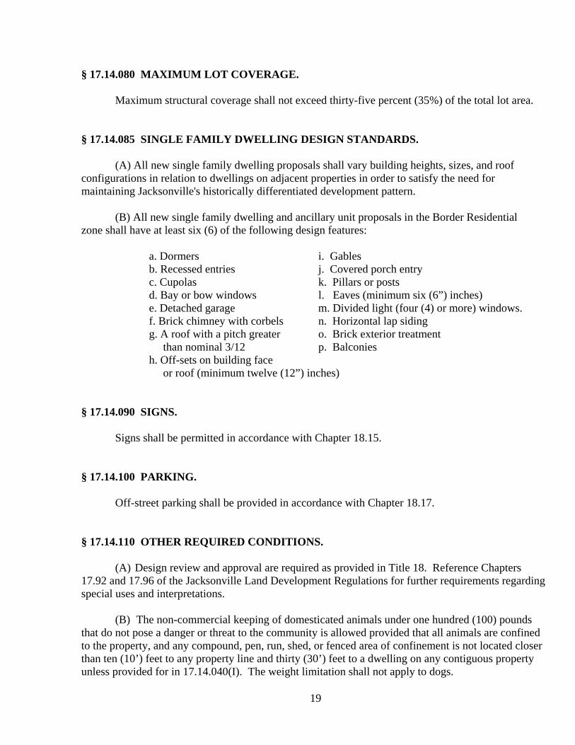
19
§ 17.14.080 MAXIMUM LOT COVERAGE. Maximum structural coverage shall not exceed thirty-five percent (35%) of the total lot area. § 17.14.085 SINGLE FAMILY DWELLING DESIGN STANDARDS. (A) All new single family dwelling proposals shall vary building heights, sizes, and roof configurations in relation to dwellings on adjacent properties in order to satisfy the need for maintaining Jacksonville's historically differentiated development pattern. (B) All new single family dwelling and ancillary unit proposals in the Border Residential zone shall have at least six (6) of the following design features: a. Dormers i. Gables
b. Recessed entries j. Covered porch entry c. Cupolas k. Pillars or posts d. Bay or bow windows l. Eaves (minimum six (6”) inches) e. Detached garage m. Divided light (four (4) or more) windows. f. Brick chimney with corbels n. Horizontal lap siding g. A roof with a pitch greater o. Brick exterior treatment than nominal 3/12 p. Balconies h. Off-sets on building face or roof (minimum twelve (12”) inches)
§ 17.14.090 SIGNS. Signs shall be permitted in accordance with Chapter 18.15. § 17.14.100 PARKING. Off-street parking shall be provided in accordance with Chapter 18.17. § 17.14.110 OTHER REQUIRED CONDITIONS.
(A) Design review and approval are required as provided in Title 18. Reference Chapters 17.92 and 17.96 of the Jacksonville Land Development Regulations for further requirements regarding special uses and interpretations.
(B) The non-commercial keeping of domesticated animals under one hundred (100) pounds that do not pose a danger or threat to the community is allowed provided that all animals are confined to the property, and any compound, pen, run, shed, or fenced area of confinement is not located closer than ten (10’) feet to any property line and thirty (30’) feet to a dwelling on any contiguous property unless provided for in 17.14.040(I). The weight limitation shall not apply to dogs.

20
(C) Development proposals shall comply with all specific Master Planning requirements found in Chapter 17.48 that are relevant to the property or properties upon which that development proposal is located or to the off-site facilities and services which are affected by that proposal.
(D) All subdivision and development proposals shall be consistent with the planned function, capacity, and level of service of any transportation facility that they may affect as identified in the TSP. Conditions may be applied by the decision making body in order to minimize impacts and protect transportation facilities, corridors, and site improvements. (E) The requirements of the Urban/Wild land Interface (Chapter 17.40), View shed Standards (Chapters 18.14) and Environmental Standards (Section 18.20.080) may be applicable to this zone, if the subject property contains natural slopes of greater than twenty percent (20%). (F) There shall be no building construction on natural slopes greater than thirty (30%), (excludes driveways and infrastructure). No driveways or infrastructure shall be permitted on natural slopes greater than thirty-five percent (35%). A “Hilfiker Wall” driveway construction technique or equivalent as determined by the City Engineer, is mandatory on natural slopes of greater than twenty percent (20%). in order to minimize cut-and-fill. (ORD. 547, passed 5-17-2005)

21
CHAPTER 17.16: HILLSIDE RESIDENTIAL (HR) DISTRICT Section
17.16.010 Purpose 17.16.020 Permitted uses 17.16.030 Accessory uses 17.16.040 Conditional uses 17.16.050 Maximum density 17.16.060 Lot width and yard minimum setback requirements 17.16.070 Maximum building height 17.16.080 Maximum lot coverage 17.16.090 Other required conditions
§ 17.16.010 PURPOSE. The purpose of the HR district is to balance, stabilize and protect the external and internal view sheds, environmental, and residential qualities of areas which, because of topography, level of services, geologic or fire hazards, or other natural or developmental factors, require special development treatments, (residential qualities being the sense of space and privacy). §17.16.020 PERMITTED USES. The following uses are permitted:
(A) Single-family dwellings.
1. One Ancillary Unit per parcel as part of the primary unit, part of a detached garage, or as a separate structure. An ancillary unit shall be no larger than sixty percent (60%) of the living space of the primary unit or one thousand (1,000’) square feet, whichever is less, and shall be subject to lot coverage and parking restrictions.
2. Planned unit developments (PUD) subject to provisions of Chapter 17.64: along with Partitions. Subdivisions without an accompanying PUD are prohibited in Hillside Residential areas.
(ORD. 547, passed 5-17-2005) 4. Management for fish and wildlife habitat, watershed, and low-impact recreation,
such as hiking and interpretive trails. § 17.16.030 ACCESSORY USES.

22
1. The following accessory uses are permitted: 2. Guest houses, not rented or otherwise conducted as a business. 3. Other accessory uses and accessory buildings and structures customarily appurtenant
to a permitted use. 4. Home occupations, subject to provisions of Chapter 17.72. 5. Rooming and boarding of not more than two (2) persons.
§ 17.16.040 CONDITIONAL USES.
1. The following conditional uses may be permitted subject to a conditional use permit: 2. Recreation uses and facilities, but not including such intensive commercial recreation
uses as a golf driving range, golf courses, swimming clubs, race-track, or amusement park.
3. Churches. 4. Hospitals, rest, nursing and convalescent homes. 5. Public, private and parochial schools, including nursery schools, kindergarten and
dancing schools, but not including a business, trade, technical or similar school. 6. Governmental structures or uses, including parks and recreation facilities, museums,
but not including storage or repair yards, fire stations, warehouses or similar uses. 7. Riding instructions and academies. 8. Public and quasi-public halls, lodges and clubs, occupying an area of not less than
five (5) acres developed to park-like recreational purposes of such nature as to enhance family living in the vicinity.
9. Within the constraints of Chapter 17.92, the keeping of domesticated farm animals provided that no such animals shall be kept on a lot less than three (3) acres in area, nor more than two (2) head may be kept on the first three (3) acres; however, one (1) additional animal may be kept for each acre over three (3) acres, and all animals must be confined to the property, and any specific area of confinement shall not be located closer than one hundred twenty-five (125’) feet to a dwelling on any contiguous property; and barns, stables and other buildings and structures to house livestock shall not be located closer than fifty (50’) feet to any property line.
10. Pumping stations with no equipment storage. 11. Bed and breakfast facilities, subject to the provisions of Section 17.92.120. 12. Historic building tours. 13. Agriculture.
(ORD. 547, passed 5-17-2005)

23
§ 17.16.050 MAXIMUM DENSITY. Maximum density in the HR zone may be two (2) dwelling units per acre (HR-.5), one (1) dwelling unit per acre (HR-1), one dwelling per two (2) acres (HR- 2), or one (1) dwelling unit per five (5) acres (HR-5) depending on the topography, service availability, surrounding land uses and other relevant characteristics of the area. The permitted ancillary units do not serve as a bonus to this density limitation. § 17.16.060 LOT WIDTH AND YARD MINIMUM SETBACK REQUIREMENTS:
Zone Average Lot Width Front Yard Rear Yard
HR-0.5 80' 20' 20'
HR-1 100' 20' 20'
HR-2 200' 20' 20'
HR-5 300' 20' 20'
Rear yard setbacks shall be a minimum of twenty (20’) feet, (plus one half (.5’) foot of setback for every foot of height of building over fifteen (15’) feet except when the requirement is waived by the decision-making body because the subject property is significantly down slope of the adjacent property to the rear). Rear yard setbacks shall be determined using the overall height of the building. Side yard setbacks shall be a minimum of ten (10’) feet, plus one half (.5’) foot of setback for every foot of height of building over fifteen (15’) feet; provided, however, that side yards abutting a street shall be a minimum of fifteen (15’) feet in width. Side yard setbacks shall be determined using the overall height of the building. An exception is allowed for small appurtenances with a maximum height of no greater than eight (8’) feet, such as garden sheds, to be setback two (2’) feet from a rear property line and an intersecting side property line (not abutting a street). This exception does not apply to swimming pools. All heat pumps or similar mechanical devices must be sited a minimum of five (5’) feet from a property line. § 17.16.070 MAXIMUM BUILDING HEIGHT.
The height of all structures shall be measured vertically from the lowest data point to the uppermost point of the roof edge or peak, wall, parapet, mansard, or other feature perpendicular to that point. In order to determine the lowest data point: the lowest exposed portion of the foundation shall be the determinant if the lowest exposed portion of the foundation is below existing natural grade; existing natural grade at the lowest exposed portion of the foundation shall be the determinant if the lowest exposed portion of the foundation is at or above existing natural grade. Maximum building

24
height shall be thirty five (35’) feet. A data point shall be set at the lowest point of exposed foundation which shall
be used to verify all building height requirements prior to alterations of natural grade. This does not apply to agricultural buildings. In case of an addition or a remodel, only the new or modified portions of the structure shall be required to comply with the incremental setback requirements associated with height calculations. This shall not be construed to waive any solar setback requirements. (ORD. 547, passed 5-17-2005) §17.16.080 MAXIMUM LOT COVERAGE. Maximum structural coverage shall not exceed thirty-five percent (35%) of the total lot area. §17.16.090 OTHER REQUIRED CONDITIONS.
(A) Design review and approval are required as provided in Title 18. Reference Chapters 17.92 and 17.96 of the Jacksonville Land Development Regulations for further requirements regarding special uses and interpretations.
(B) All requirements of the Urban/Wildland Interface (Chapter 17.40), View shed Standards (Chapter 18.14), and Environmental Standards (Section 18.20.080) shall be applicable to this zone, as determined by the decision making body.
(C) There shall be no building construction on natural slopes greater than thirty (30%) (This excludes driveways and infrastructure). No driveways or infrastructure shall be permitted on natural slopes greater than thirty-five (35%). A “Hilfiker Wall” driveway construction technique or equivalent as determined by the City Engineer is mandatory on natural slopes of greater than twenty (20%) in order to minimize cut-and-fill. (ORD. 547, passed 5-17-2005)
(D) The non-commercial keeping of domesticated animals less than one hundred (100)
pounds that do not pose a danger or threat to the community is allowed provided that all animals are confined to the property, and any compound, pen, run, shed, or fenced area of confinement is not located closer than ten (10’) feet to any property line and thirty (30’) feet to a dwelling on any contiguous property unless permitted in 17.16.040(H). The weight limitation shall not apply to dogs.
(E) Development proposals shall comply with all specific Master Planning requirements
found in Chapter 17.48 that are relevant to the property or properties upon which that development proposal is located or to the off-site facilities and services which are affected by that proposal. Off-street parking shall be required in accordance with Chapter 18.17.
(F) All subdivision and development proposals shall be consistent with the planned function, capacity, and level of service of any transportation facility that they may affect as identified in the TSP. Conditions may be applied by the decision-making body in order to minimize impacts and protect transportation facilities, corridors, and site improvements.

25

26
CHAPTER 17.20: SINGLE-FAMILY RESIDENTIAL (SF) DISTRICT
Section
17.20.010 Purpose 17.20.020 Permitted uses 17.20.030 Accessory uses 17.20.040 Conditional uses 17.20.050 Minimum lot area 17.20.060 Lot width and yard minimum setback requirements 17.20.070 Maximum building height 17.20.080 Parking 17.20.090 Other required conditions
§ 17.20.010 PURPOSE. The purpose of the SF district is to promote and encourage a suitable environment for family living and to protect and stabilize the residential characteristics of the district. The SF district is intended to provide for single-family residential homes at urban standards. § 17.20.020 PERMITTED USES. The following uses are permitted:
(A) Single-family dwellings. (B) One Ancillary Unit per lot as part of the primary unit, above a detached garage, or as a
separate structure subject to lot coverage and parking restrictions. An ancillary unit shall be no larger than sixty percent (60%) of the living space (in sq. ft.) of the primary unit or one thousand (1,000’) square feet, whichever is less.
§17.20.030 ACCESSORY USES. The following accessory uses are permitted:
1. Rooming and boarding of not more than two persons. 2. Guest houses, not rented or otherwise conducted as a business. 3. Other accessory uses, buildings and structures customarily appurtenant to a permitted
use. 4. Home occupations, subject to the provisions of Chapter 17.72.

27
§ 17.20.040 CONDITIONAL USES. The following conditional uses may be permitted subject to a conditional use permit:
1. Churches. 2. Planned unit developments subject to provisions of Chapter 17.64. 3. Horticultural Enterprises. 4. Hospitals, rest, nursing and convalescent homes. 5. Public, private and parochial schools, including nursery schools, and kindergarten,
but not including a business, dancing, trade, technical or similar school. 6. Governmental structures or uses, including parks and recreation facilities, fire
stations, libraries, museums, but not including storage or repair yards, warehouses or similar uses.
7. Bed and breakfast facilities, subject to the provisions of Section 17.92.120. 8. Historic building tours. 9. Home Occupations needing a pick-up and delivery schedule which may result in
traffic greater than that attributed to normal residential uses.
§ 17.20.050 MINIMUM LOT AREA. Minimum lot areas in the SF zone may be six thousand (6,000), eight thousand (8,000), ten thousand (10,000’) or twelve thousand (12,000’) square feet, depending upon site, public service and neighborhood characteristics. § 17.20.060 LOT WIDTH AND YARD MINIMUM SETBACK REQUIREMENTS.
Average Front Rear Maximum Zone Lot Width Yard Yard Lot Coverage SF-6 60' 20' 10' 40% SF-8 70' 20' 10' 40% SF-10 80' 20' 10' 40% SF-12 90' 20' 10' 40%
Rear yard setbacks shall be a minimum of ten (10’) feet, (plus one half (.5’) foot of setback for every foot of height of building over fifteen (15’) feet except when the requirement is waived by the body because the subject property is significantly down slope of the adjacent property to the rear). Rear yard setbacks shall be determined using the overall height of the building. Side yard setbacks shall be a minimum of five (5’) feet, plus one half (.5’) foot of setback for every foot of height of building over fifteen (15’) feet; provided, however, that side yards abutting a street shall be a minimum of fifteen (15’) feet in width. Side yard setbacks shall be determined using the overall height of the building.

28
An exception is allowed for small appurtenances with a maximum height of no greater than eight (8’) feet, such as garden sheds, to be setback two (2’) feet from a rear property line and an intersecting side property line (not abutting a street). This exception does not apply to swimming pools. All heat pumps or similar mechanical devices must be sited a minimum of five (5’) feet from a property line. § 17.20.070 MAXIMUM BUILDING HEIGHT. The height of all structures shall be measured vertically from the lowest data point to the uppermost point of the roof edge or peak, wall, parapet, mansard, or other feature perpendicular to that point. In order to determine the lowest data point: the lowest exposed portion of the foundation shall be the determinant if the lowest exposed portion of the foundation is below existing natural grade; existing natural grade at the lowest exposed portion of the foundation shall be the determinant if the lowest exposed portion of the foundation is at or above existing natural grade. Maximum building height shall be thirty-five (35’) feet. A data point shall be set at the lowest point of exposed foundation which shall be used to verify all building height requirements prior to alterations of natural grade. This does not apply to agricultural buildings. In case of an addition or a remodel, only the new or modified portions of the structure shall be required to comply with the incremental setback requirements associated with height calculations. This shall not be construed to waive any solar setback requirements. (ORD. 547, passed 5-17-2005) § 17.20.080 PARKING. Off-street parking shall be provided in accordance with Chapter 18.17. § 17.20.090 OTHER REQUIRED CONDITIONS.
(A) Design review and approval are required as provided in Title 18. Reference Chapters 17.92 and 17.96 of the Jacksonville Land Development Regulations for further requirements regarding special uses and interpretations.
(B) Within the constraints of Chapter 17.92, the non-commercial keeping of domesticated animals under one hundred (100) pounds that do not pose a danger or threat to the community is allowed provided that all animals are confined to the property, and any compound, pen, run, shed, or fenced area of confinement is not located closer than ten (10’) feet to any property line and thirty (30’) feet to a dwelling on any contiguous property. The weight limitation shall not apply to dogs.
(C) Development proposals shall comply with all specific Master Planning requirements found in Chapter 17.48 that are relevant to the property or properties upon which that development proposal is located or to the off-site facilities and services which are affected by that proposal.
(D) All subdivision and development proposals shall be consistent with the planned function,

29
capacity, and level of service of any transportation facility that they may affect as identified in the TSP. Conditions may be applied by the decision-making body in order to minimize impacts and protect transportation facilities, corridors, and site improvements.

30
CHAPTER 17.24: MULTIPLE-FAMILY RESIDENTIAL (MF) DISTRICT Section
17.24.010 Purpose 17.24.020 Permitted uses 17.24.030 Hearing and Decision-making procedures 17.24.040 Minimum lot area 17.24.050 Lot width and yard minimum setback requirements 17.24.055 Performance Standards 17.24.060 Maximum building height 17.24.070 Signs 17.24.080 Other required conditions
§ 17.24.010 PURPOSE. This district is designed to provide an environment suitable for higher-density urban residential uses. The purpose of the multi-family residential district performance review zoning standards is to buffer surrounding, less intensive uses from the potential impact of multi-family development. The MF zone is intended for residential uses, community services, appropriate professional business, and service offices. § 17.24.020 OUTRIGHT PERMITTED AND PERFORMANCE PERMITTED USES. The following are Outright Permitted uses:
1. Existing single-family dwellings 2. Multifamily dwellings, duplexes, or apartment houses 3. Townhouses which shall be applied for in accordance with Chapter 17.64 4. Rooming and boarding houses and group living 5. Offices incidental and necessary to the conduct of a permitted use 6. Off-street parking lots when appurtenant to a Permitted Use, subject to the provisions
of Chapter 18.17.
In order to grant approval for any use, the planning commission must find, based upon evidence, both factual and supportive, provided by the applicant, that:
1. The proposal is in compliance with the comprehensive plan. 2. All requirements of this Chapter are satisfied. 3. There is no outstanding code or conditional requirements on the subject property.
(Am. Ord. 579, passed 3-4-2008)

31
§ 17.24.030 HEARING AND DECISION-MAKING PROCEDURES. Performance Review is a limited land use decision and shall be conducted by the Planning Commission as prescribed in Chapter 18.05 of the Jacksonville Municipal Code. Notice shall be provided pursuant to Chapter 18.04.010.
The following Performance Permitted uses are subject to review under section 17.24.030 and 17.24.055:
(A) Necessary and incidental services such as a dining room, barber shop, beauty shop, hobby
shop, etc., included within apartment buildings, provided that the facilities are used by and services rendered to, only tenants of the buildings and their guests.
(B) Churches. (C) Bed and breakfast facilities, subject to the provisions of Section 17.92.120. (D) Hospitals, rest, nursing and convalescent homes. (E) Public, private and parochial schools, including nursery schools, kindergarten and day
nurseries, but not including a business, dancing, trade, technical or similar school. (F) Governmental structures or uses including parks and recreation facilities, fire stations,
libraries, museums, but not including storage or repair yards, warehouses or similar uses. (G) Off-street parking lots when contiguous to a less restrictive zoning district. For development
standards see Chapter 18.17. (H) Historic building tours. (I) Public and quasi-public halls, lodges and clubs. (J) Recreation uses and facilities, including country clubs, golf course and appurtenant
facilities, swimming clubs, but not including such intensive commercial recreation uses as a golf driving range not affiliated with a golf course, race track or amusement park.
(K) Manufactured Dwelling Parks pursuant to the requirements of Chapter 17.44.
(L) Senior Housing Facilities as defined in 17.08.060.
(Am. Ord. 579, passed 3-4-2008) § 17.24.040 MINIMUM LOT AREA. The minimum lot area shall be five thousand (5,000’) square feet for two-family dwellings; for each additional dwelling unit, the lot area shall be increased by two thousand-four hundred (2,400’) square feet.

32
§ 17.24.050 LOT WIDTH AND YARD MINIMUM SETBACK REQUIREMENTS.
Average Front Rear Maximum Lot Width Yard Yard Lot Coverage
50' 20' 15' 50%
Rear yard setbacks shall be a minimum of fifteen (15’) feet, (plus one half (.5’) foot of setback for every foot of height of building over fifteen (15’) feet except when the requirement is waived by the decision-making body because the subject property is significantly down slope of the adjacent property to the rear). Rear yard setbacks shall be determined using the overall height of the building. Side yard setbacks shall be a minimum of five (5’) feet, plus one half (.5’) foot of setback for every foot of height of building over fifteen (15’) feet; provided, however, that side yards abutting a street shall be a minimum of fifteen (15’) feet in width. Side yard setbacks shall be determined using the overall height of the building. All heat pumps or similar mechanical devices must be sited a minimum of five (5’) feet from a property line. Notwithstanding the above "Side Yard" requirement, common wall townhouses may be permitted subject to Fire Department approval. § 17.24.055 PERFORMANCE STANDARDS. The above-listed uses may be permitted subject to a review and a determination of compliance with the following performance standards:
(A) The proposed use shall preserve the historic integrity of and provide affirmative maintenance for structures and sites included on the Jacksonville Landmark List. For changes in all structures and sites which are on the list, a finding of compatibility must be made in accordance with the requirements of Title 18, Historic Protection Regulations.
(B) All business, services and processes shall be conducted entirely within a completely enclosed structure, except for off-street parking and loading areas, or recreation areas.
(C) All subdivision and development proposals shall be consistent with the planned function,
capacity, and level of service of any transportation facility that they may affect as identified in the TSP. Conditions may be applied by the decision-making body in order to minimize impacts and protect transportation facilities, corridors, and site improvements.
(D) The maximum lot coverage allowable on a lot shall be fifty (50’) feet and shall be subject
to the additional impervious surface requirements of Chapter 18.21. (E) Site Plan and Historical & Architectural Review Commission review shall be required as
provided in Title 18.

33
The applicant must submit a development proposal to substantiate conformance with the above performance standards. The applicant shall submit the following elements, as applicable to the proposal (Applicability shall be determined by the City Planner): Pedestrian Plan: A pedestrian circulation plan must provide adequate pedestrian access in the vicinity
and within the project. The plan must provide compacted, safely lit walkways and entrances suitable for use by the handicapped.
Traffic Plan: A traffic plan must provide adequate vehicle circulation in the vicinity of and within the
project. The traffic plan must coordinate internal and external transportation networks, including bikeways and mass transit to extent possible. Traffic noise must be minimized.
Loading Plan: A plan for loading dock or space must provide adequate room for safe truck backing and
turning movements. Open Space Plan: A plan assuring that alterations and additions to existing buildings, and new
construction, are compatible with neighboring uses in terms of the relative proportion of impervious/covered area to open space. Any landscape alterations for commercial, educational, or professional uses shall be made in accordance with the standards contained in Section 18.18.030.
Parking Plan: Off-street parking shall be provided in accordance with Chapter 18.17. Public Safety Plan: A plan must minimize the likelihood of criminal activity by eliminating areas that are
neither clearly private nor clearly public and by using landscaping that allows maximum observation while providing desired aesthetics.
Perimeter Plan: A plan for the perimeter of the project to protect adjacent properties from noise, visual
incompatibility, light glare, heat pumps, fans, or other potential nuisances. This may be accomplished through screening, setbacks, site review, or other means.
A determination of compliance may be made subject to certain conditions. In permitting a use, the Planning Commission may impose, in addition to regulations and standards expressly specified in the Unified Development Code, other conditions found necessary to protect the best interests of the surrounding property or neighborhood, or the city as a whole. These conditions may include, but not be limited to, the following:

34
1. Development of a Preservation Plan for historic sites and structures. 2. Requiring fences, walls or landscape screening and/or buffering where necessary to
reduce noise, glare and maintain the property in a character in keeping with the surrounding area.
3. Requiring landscaping and maintenance. 4. Increasing street widths, controlling the location and number of vehicular access points
to the property for ingress/egress. 5. Requiring means of pedestrian/bicycle access pathways to serve the property. 6. Increasing the number of required off-street parking, loading spaces, surfacing and
proper drainage of parking areas. 7. Limiting size, location and number of signs. 8. Limiting the location, coverage or height of buildings because of obstructions to view
and reduction of light and air to adjacent property. 9. Limiting or prohibiting openings in sides of buildings or structures. 10. Enclosure of storage areas and limitation of outside display and/or storage of
merchandise. 11. Requiring maintenance of grounds. 12. Regulation of noise, vibration, odors, etc. 13. Regulation of time for certain activities. 14. Establishing a time period within which the proposed use shall be developed. 15. The requirement of a bond for removal of such use within a specified period of time. 16. Requirements under which any future enlargement or alteration of the use shall be
reviewed by the Planning Commission and new conditions imposed. 17. Increasing required lot size, yard dimensions, open space or buffer areas. 18. And such other conditions as will make possible the development of the city in an
orderly and efficient manner and in conformity with the intent and purposes set forth in this chapter.
If a business at a previously-reviewed location is changing to a business of similar or lesser intensity (and there are no outstanding code violations on the property), any subsequent review processes may be handled administratively. Staff may refer any application that it deems necessary to the Planning Commission. (ORD. 547, passed 5-17-2005)

35
§ 17.24.060 MAXIMUM BUILDING HEIGHT.
The height of all structures shall be measured vertically from the lowest data point n to the uppermost point of the roof edge or peak, wall, parapet, mansard, or other feature perpendicular to that point. In order to determine the lowest data point: the lowest exposed portion of the foundation shall be the determinant if the lowest exposed portion of the foundation is below existing natural grade; existing natural grade at the lowest exposed portion of the foundation shall be the determinant if the lowest exposed portion of the foundation is at or above existing natural grade. Maximum building height shall be thirty five (35’) feet. A data point shall be set at the lowest point of exposed foundation which shall be used to verify all building height requirements prior to alterations of natural grade. This does not apply to agricultural buildings. In case of an addition or a remodel, only the new or modified portions of the structure shall be required to comply with the incremental setback requirements associated with height calculations. This shall not be construed to waive any solar setback requirements. (ORD. 547, passed 5-17-2005) § 17.24.070 SIGNS. Signs may be permitted in accordance with the provisions of Chapter 18.15. § 17.24.080 OTHER REQUIRED CONDITIONS.
(A) Design review and approval are required as provided in Title 18. Reference Chapters 17.92 and 17.96 of the Jacksonville Land Development Regulations for further requirements regarding special uses and interpretations.
(B) Where a site adjoins or is located across an alley from an existing residence, a solid
wall or fence, vine-covered open fence or compact evergreen hedge six (6’) feet in height shall be located on the property line, except in a required front yard area.
(C) Bicycle Parking shall be provided in accordance with Chapter 18.17, along with
pedestrian linkage to other common destinations and attractors. Secure bicycle parking shall be located in relation to key entrances so as to be no less convenient than vehicle parking.
(D) Buildings shall be oriented to face streetscape and pedestrian facilities to the maximum
extent possible. Internal pedestrian circulation in new developments shall be provided through clustering of buildings, construction of pedestrian ways, and similar techniques.
(E) Development proposals shall comply with all specific Master Planning requirements
found in Chapter 17.48 that are relevant to the property or properties upon which that development proposal is located or to the off-site facilities and services which are affected by that proposal.

36
(F) Within the constraints of Chapter 17.92, the non-commercial keeping of domesticated
animals under one hundred (100) pounds that do not pose a danger or threat to the community is allowed provided that all animals are confined to the property, and any compound, pen, run, shed, or fenced area of confinement is not located closer than ten (10’) feet to any property line and thirty (30’) feet to a dwelling on any contiguous property. The weight limitation shall not apply to dogs.
(G) All proposals shall be encouraged to maximize passive or active solar usage, conserve
water, and provide any other means of conserving energy. (Ord. 584, passed 12-2-2008)

37
CHAPTER 17.28: ARTISAN (AR) DISTRICT
Section
17.28.010 Purpose 17.28.020 Performance Permitted uses 17.28.030 Accessory uses 17.28.035 Hearing and Decision-making procedures 17.28.040 Performance Standards 17.28.050 Maximum building height 17.28.060 Signs 17.28.070 Parking 17.28.080 Other required conditions
§ 17.28.010 PURPOSE. The purpose of the Artisan District is to provide opportunity for the manufacturing of fabricated craft and artwork made onsite to be sold as retail from a property in addition to being used as a residence. The district is designed to continue protection of the historical characteristics of the City of Jacksonville. § 17.28.020 PERFORMANCE PERMITTED USES. The following uses and their accessory uses are permitted subject to a satisfactory Performance Review:
(A) Product creation or fabrication, educational and professional operations and activities. Non residential uses shall not exceed sixty-five percent (65%) of the total gross floor area and must accompany a residential structure.
(B) Residential uses, provided that at least thirty percent (30%) of the total gross floor area of
the ground floor, or at least twenty-five percent (25%) of the total lot area if there are multiple buildings shall be designated for permitted uses, excluding residential.
(C) One (1) Ancillary Unit per lot as part of the primary unit, above a detached garage, or as a
separate structure subject to lot coverage and parking restrictions. Ancillary units shall be no larger than sixty percent (60%) of the gross floor area of the primary unit, or one thousand (1,000’) square feet, whichever is less. The ancillary unit gross floor area shall not be incorporated into the related subsections A or B calculations.
(D) Rooming and boarding of not more than two (2) persons.
(E) Specialty agricultural uses and other uses including wineries and other agricultural processing facilities.

38
(F) Motion picture, television, or radio broadcasting studios.
(G) In addition to a residential use, retail uses shall be permitted provided that seventy-five percent (75%) of the retail activity shall be associated with the primary use activity on the property. In order to grant approval for any use, the planning commission must find, based upon evidence, both factual and supportive, provided by the applicant, that:
(a) The proposal is in compliance with the comprehensive plan. (b) All requirements of this Chapter are satisfied. (c) There are no outstanding codes or conditional requirements on the subject property that have not been remedied.
(Ord. 584, passed 12-2-2008)
§ 17.28.030 HEARING AND DECISION-MAKING PROCEDURES. Performance Review is a limited land use decision and shall be conducted by the Planning Commission as prescribed in Chapter 18.05 of the Jacksonville Municipal Code. Notice shall be provided pursuant to Chapter 18.04.010.
§ 17.28.040 PERFORMANCE STANDARDS. The above-listed uses may be permitted subject to a review and a determination of compliance with the following performance standards:
(A) The proposed use shall preserve the historic integrity of and provide affirmative maintenance for structures and sites included on the Jacksonville Landmark List. For changes in all structures and sites which are on the list, a finding of compatibility must be made in accordance with the requirements of Title 18, Historic Protection Regulations.
(B) All objectionable odors associated with the use shall be confined to the lot upon which the use is located, to the greatest extent feasible. For the purposes of this provision, the standard for judging "objectionable odors" shall be that of an average, reasonable person with ordinary sensibilities. Odors which are in violation of this standard include but are not limited to the following:
1. Odors from fermenting food products. 2. Odors from decaying organic substances or human or animal wastes.
(C) The use shall comply with all requirements of the Oregon Department of Environmental
Quality. (D) All business, services and processes shall be conducted entirely within a completely
enclosed structure, except for off-street parking and loading areas, outdoor dining areas, nurseries, garden shops and other similar uses.

39
(E) The maximum lot coverage allowable on a lot shall be sixty percent (60%) and shall be subject to the additional impervious surface requirements of Chapter 18.21.
(F) Site Plan and Historical & Architectural Review Commission review shall be required as
provided in Title 18. The applicant must submit a development proposal to substantiate conformance with the above performance standards. The applicant shall submit the following elements, as applicable to the proposal: (Applicability shall be determined by the City Planner).
Pedestrian Plan:
A pedestrian circulation plan must provide adequate pedestrian access in the vicinity and within the project and provide compacted, safely lighted walkways and entrances suitable for use by the handicapped.
Traffic Plan:
A traffic plan must provide adequate vehicle circulation in the vicinity of and within the project. The traffic plan must coordinate internal and external transportation networks, including bikeways and mass transit to extent possible. Traffic noise must be minimized.
Loading Plan:
A plan for loading dock or space must provide adequate room for safe truck backing and turning movements.
Criminal Prevention Plan:
A plan for minimizing the likelihood of criminal activity by eliminating areas considered to be neither clearly private nor clearly public and by using landscaping that allows maximum observation while providing desired aesthetics.
Parking Plan:
A parking plan requires adequate, convenient, well-marked and safely lit off-street parking. Include shade trees and landscaping to ameliorate the effect of paved areas using the standards contained in Section 18.18.030. Handicapped access is required. Loading areas must be safely integrated.
Perimeter Plan: A plan for the perimeter of the project to protect adjacent properties from noise, visual
incompatibility, light glare, heat pumps, fans, or other potential nuisances. This may be accomplished through screening, setbacks, site review, or other means.

40
A determination of compliance may be made subject to certain conditions. In permitting a use, the Planning Commission may impose, in addition to regulations and standards expressly specified in the Unified Development Code, other conditions found necessary to protect the best interests of the surrounding property or neighborhood, or the city as a whole. These conditions may include, but not be limited to, the following:
1. Development of a Preservation Plan for historic sites and structures. 2. Requiring fences, walls or landscape screening and/or buffering where necessary to
reduce noise, glare and maintain the property in a character in keeping with the surrounding area.
3. Requiring landscaping and maintenance. 4. Increasing street widths, controlling the location and number of vehicular access points
to the property for ingress/egress. 5. Requiring means of pedestrian/bicycle access pathways to serve the property. 6. Increasing the number of off-street parking and loading spaces required. Surfacing and
proper drainage of parking areas. 7. Limiting size, location and number of signs. 8. Limiting the location, coverage or height of buildings because of obstructions to an
identified view shed and reduction of light and air to adjacent property. 9. Limiting or prohibiting openings in sides of buildings or structures. 10. Enclosure of storage areas and limitation of outside display and/or storage of
merchandise. 11. Requiring maintenance of grounds. 12. Regulation of noise, vibration, odors, etc. 13. Regulation of time for certain activities. 14. Establishing a time period within which the proposed use shall be developed. 15. The requirement of a bond for removal of such use within a specified period of time. 16. Requirements under which any future enlargement or alteration of the use shall be
reviewed by the Planning Commission and new conditions imposed. 17. Increasing required lot size, yard dimensions, open spaces and/or buffer areas. 18. And such other conditions as will make possible the development of the city in an
orderly and efficient manner and in conformity with the intent and purposes set forth in this chapter.
If a business at a previously-reviewed location is changing to a business of similar or lesser intensity (and there are no outstanding code violations on the property), any subsequent review processes may be handled administratively. Staff may refer any application that it deems necessary to the Planning Commission.
§ 17.28.050 MAXIMUM BUILDING HEIGHT.
The height of all structures shall be measured vertically from the lowest exposed data point to the uppermost point of the roof edge or peak, wall, parapet, mansard, or other feature perpendicular to that point. In order to determine the lowest data point: the lowest exposed portion of the foundation shall be the determinant if the lowest exposed portion of the foundation is at or above existing natural grade. Maximum building height shall be thirty five (35’) feet. A data point shall be set at the lowest

41
point of exposed foundation which shall be used to verify all building height requirements prior to alterations of natural grade. This does not apply to agricultural buildings. In case of an addition or a remodel, only the new or modified portions of the structure shall be required to comply with the incremental setback requirements associated with height calculations. This shall not be construed to waive any solar setback requirements. (ORD. 547, passed 5-17-2005) § 17.28.060 SIGNS. Signs may be permitted in accordance with the provisions of Chapter 18.15. § 17.28.070 PARKING. Off-street parking and Bicycle Parking shall be provided in accordance with Chapter 18.17, along with pedestrian linkage to other key destinations and attractors. Secure bicycle parking shall be located in relation to key entrances so as to be no less convenient than vehicle parking. § 17.28.080 OTHER REQUIRED CONDITIONS.
(A) Design review and approval are required as provided in Title 18. Reference Chapters 17.92 and 17.96 of the Jacksonville Land Development Regulations for further requirements regarding special uses and interpretations.
(B) All uses are subject to the requirements that 1) mechanical equipment be either enclosed in a structure or fully screened and buffered 2) the applicant acknowledge having read and understood the applicability of the noise provisions of Chapter 9 of the Jacksonville Municipal Code to the proposed use; and 3) all outside storage areas relating to non-residential uses permitted in this zone shall be either fully enclosed or screened using fences, walls or landscape screening and/or buffering where necessary to reduce visual impact of the neighborhood.
(C) There shall be no area or width requirements except as may be required to adequately
satisfy the above Unified Development Code standards.
(D) Buildings shall be oriented to face streetscape and pedestrian facilities to the maximum extent possible.
(E) Development proposals shall comply with all specific Master Planning requirements found in Chapter 17.48 that are relevant to the property or properties upon which that development proposal is located or to the off-site facilities and services which are affected by that proposal.
(F) All proposals shall be encouraged to maximize passive or active solar usage, conserve water, and provide any other means of conserving energy.
(G) All development proposals shall be consistent with the planned function, capacity, and

42
level of service of any transportation facility that they may affect as identified in the TSP. Conditions may be applied by the decision-making body in order to minimize impacts and protect transportation facilities, corridors, and site improvements.
(H) Where a site adjoins or is located across an alley from an existing residence, a solid wall or fence, vine-covered open fence or compact evergreen hedge six (6’) feet in height shall be located on the property line, except in a required front yard area.
(I) Within the constraints of Chapter 17.92, the non-commercial keeping of domesticated
animals under one hundred (100) pounds that do not pose a danger or threat to the community is allowed provided that all animals are confined to the property, and any compound, pen, run, shed, or fenced area of confinement is not located closer than ten (10’) feet to any property line and thirty (30’) feet to a dwelling on any contiguous property. The weight limitation shall not apply to dogs. (Ord. 584, passed 12-2-2008)

43
CHAPTER 17.32: GENERAL COMMERCIAL (GC) DISTRICT
Section
17.32.010 Purpose 17.32.020 Permitted uses 17.32.030 Hearing and Decision-making procedures 17.32.040 Performance standards 17.32.050 Maximum building height 17.32.060 Signs 17.32.070 Other required conditions
§ 17.32.010 PURPOSE. This district is designed to make provisions within the city for concentrations of retailing and service commercial activities. The purpose of the general commercial district performance review zoning standards is to ensure that the intensity of development remains compatible with surrounding uses. Development within this district has historically followed the prevailing pattern in the city, which is one of differentiation and uniqueness. § 17.32.020 PERMITTED USES. The following uses are permitted in a GC general commercial district:
(A) Commercial and public uses.
(B) Residential uses, provided that at least sixty- five percent (65%) of the total gross floor area of the ground floor, or at least fifty percent (50%) of the total projected area if there are multiple buildings shall be designated for permitted uses, excluding residential.
(C) Planned unit developments subject to the provisions of Chapter 17.64 or subdivision/partitions associated with an approved planned unit development plan. (Ord. 579, passed 3-4-2008) In order to grant approval for any use, the planning commission must find, based upon evidence, both factual and supportive, provided by the applicant, that:
1. The proposal is in compliance with the comprehensive plan. 2. All requirements of this Chapter are satisfied. 3. There are no outstanding codes or conditional requirements on the subject property.

44
§ 17.32.030 HEARING AND DECISION-MAKING PROCEDURES. Performance Review is a limited land use decision and shall be conducted by the Planning Commission as prescribed in Chapter 18.05 of the Jacksonville Municipal Code. Notice shall be provided pursuant to Chapter 18.04.010. § 17.32.040 PERFORMANCE STANDARDS. The above-listed uses may be permitted subject to a review and a determination of compliance with the following performance standards:
(A) The proposed use shall preserve the historic integrity of and provide affirmative maintenance for structures and sites included on the Jacksonville Landmark List. For changes in all structures and sites which are on the list, a finding of compatibility must be made in accordance with the requirements of Title 18, Historic Protection Regulations.
(B) All objectionable odors associated with the use shall be confined to the lot upon which the
use is located, to the greatest extent feasible. For the purposes of this provision, the standard for judging "objectionable odors" shall be that of an average, reasonable person with ordinary sensibilities. Odors which are in violation of this standard include but are not limited to the following:
(a) Odors from fermenting food products. (b) Odors from decaying organic substances or human or animal wastes.
The use shall comply with all requirements of the Oregon Department of Environmental Quality.
(C) All business, services and processes shall be conducted entirely within a completely
enclosed structure, except for off-street parking and loading areas, gasoline service stations, outdoor dining entertainment or recreation areas, nurseries, garden shops, Christmas tree sales lots, and bus stations.
(D) All subdivision and development proposals shall be consistent with the planned function,
capacity, and level of service of any transportation facility that they may affect as identified in the TSP. Conditions may be applied by the decision-making body in order to minimize impacts and protect transportation facilities, corridors, and site improvements.
(E) There shall be no area or width requirements except as may be required to adequately
satisfy the above Unified Development Code standards. (F) Site Plan and Historical & Architectural Review Commission review shall be required as
provided in Title 18. The applicant must submit a development proposal to substantiate conformance with the above performance standards. The applicant shall submit the following elements, as applicable to the proposal: (Applicability shall be determined by the City Planner).

45
Pedestrian Plan: A pedestrian circulation plan must provide adequate pedestrian access in the vicinity
and within the project. The plan must provide compacted, safely lighted walkways and entrances suitable for use by the handicapped.
Traffic Plan: A traffic plan must provide adequate vehicle circulation in the vicinity of and within the
project. The traffic plan must coordinate internal and external transportation networks, including bikeways and mass transit to extent possible. Traffic noise must be minimized.
Loading Plan: A plan for loading dock or space must provide adequate room for safe truck backing and
turning movements. Open Space Plan: A plan must assure that alterations and additions to existing buildings, and new
construction, are compatible with neighboring uses in terms of the relative proportion of impervious/covered area to open space. Any landscape alterations for commercial, educational, or professional uses shall be made in accordance with the standards contained in Section 18.18.030.
Parking Plan: Off-street parking shall be provided in accordance with Chapter 18.17. Public Safety Plan: A plan must minimize the likelihood of criminal activity by eliminating areas
considered to be neither clearly private nor clearly public and by using landscaping that allows maximum observation while providing desired aesthetics.
Perimeter Plan: A plan for the perimeter of the project to protect adjacent properties from noise, visual
incompatibility, light glare, heat pumps, fans, or other potential nuisances. This may be accomplished through screening, setbacks, site review, or other means.

46
A determination of compliance may be made subject to certain conditions. In permitting a use, the Planning Commission may impose, in addition to regulations and standards expressly specified in the Unified Development Code, other conditions found necessary to protect the best interests of the surrounding property or neighborhood, or the city as a whole. These conditions may include, but not be limited to, the following:
1. Development of a Preservation Plan for historic sites and structures. 2. Requiring fences, walls or landscape screening and/or buffering where necessary to
reduce noise, glare and maintain the property in a character in keeping with the surrounding area.
3. Requiring landscaping and maintenance. 4. Increasing street widths, controlling the location and number of vehicular access points
to the property for ingress/egress. 5. Requiring means of pedestrian/bicycle access pathways to serve the property. 6. Increasing the number of off-street parking and loading spaces required. Surfacing and
proper drainage of parking areas. 7. Limiting size, location and number of signs. 8. Limiting the location, coverage or height of buildings because of obstructions to view
and reduction of light and air to adjacent property. 9. Limiting or prohibiting openings in sides of buildings or structures. 10. Enclosure of storage areas and limitation of outside display and/or storage of
merchandise. 11. Requiring maintenance of grounds. 12. Regulation of noise, vibration, odors, etc. 13. Regulation of time for certain activities. 14. Establishing a time period within which the proposed use shall be developed. 15. The requirement of a bond for removal of such use within a specified period of time. 16. Requirements under which any future enlargement or alteration of the use shall be
reviewed by the Planning Commission and new conditions imposed. 17. Increasing required lot size, yard dimensions, open spaces or buffer areas. 18. And such other conditions as will make possible the development of the city in an
orderly and efficient manner and in conformity with the intent and purposes set forth in this chapter.
If a business at previously-reviewed location is changing to a business of similar or lesser
intensity (and there are no outstanding code violations on the property), any subsequent review processes may be handled administratively. Staff may refer any application that it deems necessary to the Planning Commission. (ORD. 547, passed 5-17-2005)

47
§ 17.32.050 MAXIMUM BUILDING HEIGHT. The height of all structures shall be measured vertically from the lowest data point to the uppermost point of the roof edge or peak, wall, parapet, mansard, or other feature perpendicular to that point. In order to determine the lowest data point: the lowest exposed portion of the foundation shall be the determinant if the lowest exposed portion of the foundation is below existing natural grade; existing natural grade at the lowest exposed portion of the foundation shall be the determinant if the lowest exposed portion of the foundation is at or above existing natural grade. Maximum building height shall be thirty five (35’) feet. A data point shall be set at the lowest point of exposed foundation which shall be used to verify all building height requirements prior to alterations of natural grade. In the case of an addition or a remodel, only the new or modified portions of the structure shall be required to comply with the incremental setback requirements associated with height calculations. This shall not be construed to waive any solar setback requirements. (ORD. 547, passed 5-17-2005) § 17.32.060 SIGNS. Signs may be permitted in accordance with the provisions of Chapter 18.15. § 17.32.070 OTHER REQUIRED CONDITIONS.
(A) Where a site adjoins or is located across an alley from a residential district, a solid wall or fence, vine-covered open fence or compact evergreen hedge six (6’) feet in height shall be located on the property line, common to such districts, except in a required front yard area.
(B) Design review and approval are required as provided in Title 18. Reference Chapters
17.92 and 17.96 of the Jacksonville Land Development Regulations for further requirements regarding special uses and interpretations.
(C) All uses are subject to the requirements that 1) mechanical equipment be either
enclosed in a structure or fully screened and buffered and 2) the applicant acknowledge having read and understood the applicability of the noise provisions of Section 8.04.150 of the Jacksonville Municipal Code to the proposed use.
(D) Buildings shall be oriented to face streetscape and pedestrian facilities to the maximum
extent possible. Internal pedestrian circulation in new developments shall be provided through clustering of buildings, construction of pedestrian ways, and similar techniques.
(E) The following criteria will be used to ensure that the prevailing development pattern
described in the purpose is maintained.
1. Setbacks will be varied in relation to adjacent properties. 2. Parking must be in the rear or on the side, unless otherwise impractical. 3. If rear parking is not feasible, a landscaping plan to shield parking from street
view will be required. A landscape plan would be subject to Planning Commission approval.

48
(F) Development proposals shall comply with all specific Master Planning requirements found in Chapter 17.48 that are relevant to the property or properties upon which that development proposal is located or to the off-site facilities and services which are affected by that proposal.
(G) Bicycle Parking shall be provided in accordance with Chapter 18.17, along with
pedestrian linkage to other common destinations and attractors. Secure bicycle parking shall be located in relation to key entrances so as to be no less convenient than vehicle parking.
(H) All proposals shall be encouraged to maximize passive or active solar usage, conserve
water, and provide any other means of conserving energy.
If a business at a previously-reviewed location is changing to a business of similar or lesser intensity (and there are no outstanding code violations on the property), any subsequent review processes may be handled administratively. Staff may refer any application that it deems necessary to the Planning Commission. (Ord. 584, passed 12-2-2008)
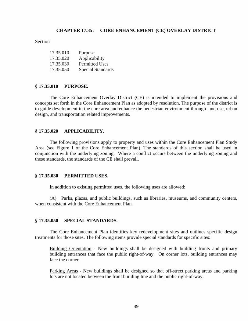
49
CHAPTER 17.35: CORE ENHANCEMENT (CE) OVERLAY DISTRICT
Section
17.35.010 Purpose 17.35.020 Applicability 17.35.030 Permitted Uses 17.35.050 Special Standards
§ 17.35.010 PURPOSE.
The Core Enhancement Overlay District (CE) is intended to implement the provisions and concepts set forth in the Core Enhancement Plan as adopted by resolution. The purpose of the district is to guide development in the core area and enhance the pedestrian environment through land use, urban design, and transportation related improvements. § 17.35.020 APPLICABILITY.
The following provisions apply to property and uses within the Core Enhancement Plan Study Area (see Figure 1 of the Core Enhancement Plan). The standards of this section shall be used in conjunction with the underlying zoning. Where a conflict occurs between the underlying zoning and these standards, the standards of the CE shall prevail. § 17.35.030 PERMITTED USES.
In addition to existing permitted uses, the following uses are allowed:
(A) Parks, plazas, and public buildings, such as libraries, museums, and community centers, when consistent with the Core Enhancement Plan. § 17.35.050 SPECIAL STANDARDS.
The Core Enhancement Plan identifies key redevelopment sites and outlines specific design treatments for those sites. The following items provide special standards for specific sites:
Building Orientation - New buildings shall be designed with building fronts and primary building entrances that face the public right-of-way. On corner lots, building entrances may face the corner. Parking Areas - New buildings shall be designed so that off-street parking areas and parking lots are not located between the front building line and the public right-of-way.

50
Design Features -
1. Metal or wood shed awnings are permitted on both sides of California Street. The
awnings shall not bisect transom windows.
2. Based upon City Council approval, pedestrian amenities, such as cafe seating and benches, are permitted in the public right-of-way when located consistent with Figure 4 of the Core Enhancement Plan.

51
CHAPTER 17.36: HISTORICAL CORE (HC) DISTRICT Section
17.36.010 Purpose 17.36.020 Permitted uses 17.36.030 Accessory uses 17.36.035 Hearing and Decision-making procedures 17.36.040 Performance Standards 17.36.050 Maximum building height 17.36.060 Signs 17.36.070 Other required conditions
§ 17.36.010 PURPOSE. This district is designed to stabilize, protect and enhance the historical characteristics of the central core of the City of Jacksonville for the enjoyment of the general public while preserving the livability and economic viability of the individual property owners. A key objective shall be to preserve the historic integrity of and provide affirmative maintenance for structures and sites included on the Jacksonville Landmark List. The historic commercial concentration between and adjacent to Main-and-'C' Streets and 1st-and-5th Streets is contained within this larger district as a sub-area, and is subject to the additional specific requirements of the 'Core Enhancement Plan' as adopted by resolution and as described in Chapter 17.35, which promotes commercial uses of land with particular emphasis upon compatibility with the unique historical character of the concentrated downtown business district. Where a conflict occurs between the standards contained herein and the specific requirements of the 'Core Enhancement Plan', the specific requirements shall prevail. § 17.36.020 PERMITTED USES. The following uses are permitted in the HC historical core district subject to a satisfactory performance review:
(A) Commercial, educational and professional operations and activities;
1. Landowners may apply for a peddler performance review allowing business to be conducted outside of a completely enclosed structure provided that:
(a) The use will not exceed two (2) days per week. The two (2) days must be consecutive (ie. Friday and Saturday or Saturday and Sunday).

52
(b) The outward historic appearance of downtown must be preserved. The following are examples of design that demonstrates historic compliance.
(i) Stainless steel or other highly reflective materials (excluding transparent glass) are not to be visible from six (6’) feet centerline of the street.
(ii) Artificial illumination is not allowed. (iii) Power cords and other wiring must not be visible from six (6’) feet centerline
of the street. (c) All materials associated with the use will be removed from the property at the close of the business on the second day and not return until the start of the next approved business day. (d) A sign may be maintained in conjunction with the use, provided it is no greater than two square (2’) feet, provided it is fabricated from materials reflecting
historic standards such as wood or canvas, and meets the standards of Title 18 Section 18.16. Graphic displays on structures associated with the peddler’s business are subject to sign code approval.
(e) Businesses shall be oriented to attract pedestrians. No increase in vehicular traffic may be expected. Applicants are subject to Parking District participation
(f) Hazardous materials (including toxic, explosive, noxious, combustible or flammable as determined by the Public Safety Department Chief beyond that normally incidental to the use is prohibited. (g) There shall be no emission of odorous, toxic or noxious matter or any use causing electrical or telecommunication interference, vibration, noise, heat or glare in such quantities as to be readily detectable at any point along or outside property lines so as to produce a public nuisance or hazard. (h) Business shall supply and maintain a refuse container with minimal visual impacts. (i) Motorized vehicles will not be sold.
(B) Residential uses. (C) Residential uses in combination with commercial and professional uses. (D) Outdoor entertainment or dancing.
(Am. ORD 579, 3-4-08) This section specifically does not include:
1. Prohibited peddlers or mobile sales stands and pushcarts. 2. Sale of liquor, beer or other alcoholic beverages for consumption on the premises without a security plan that has been approved by the City Council.
§ 17.36.030 ACCESSORY USES. Any uses in buildings customarily appurtenant to a permitted use, such as incidental storage, are permitted.

53
§ 17.36.035 HEARING AND DECISION-MAKING PROCEDURES. Performance Review is a limited land use decision and shall be conducted by the Planning Commission as prescribed in Chapter 18.05 of the Jacksonville Municipal Code. Notice shall be provided pursuant to Chapter 18.04.010. § 17.36.040 PERFORMANCE USE STANDARDS. Except in the Historic Commercial District sub-area, single-family residential uses are permitted outright without review, unless structural or site design changes are proposed. If such changes are proposed then the proposal shall be reviewed for a determination of compliance with the following performance standards. Commercial, educational, professional, and multi-family uses (and single-family residential uses in the Historic Commercial District sub-area) may be permitted subject to a review and a determination of compliance with the following performance standards:
(A) The proposed use shall preserve the historic integrity of and provide affirmative maintenance for structures and sites included on the Jacksonville Landmark List. For changes in all structures and sites which are in the district, a finding of compatibility must be made in accordance with the requirements of Title 18, Historic Protection Regulations.
(B) Uses with a precedent in Jacksonville's Historic Context (after the date of City's incorporation, October 11, 1860) shall be encouraged. For uses without such a precedent, a finding of compatibility with the Jacksonville Historic Context Statement must be made by HARC.
(C) No use shall be permitted and no process, equipment or materials shall be used which are found by the planning commission to be harmful or a public nuisance to persons living or working in the vicinity by reason of odor, fumes, dust, smoke, cinders, dirt refuse, water-carried waste, noise, vibration, illumination, glare or unsightliness, or to involve any hazard of fire or explosion.
(D) All business, services and processes shall be conducted entirely within a completely enclosed structure, except for off-street parking and loading areas; gasoline service stations; outdoor dining, entertainment, or recreation areas; nurseries; garden shops; Christmas tree sales lots; and bus stations.
(E) Participation in the downtown parking district for both automobiles and bicycles shall be required for all commercial and professional enterprises and operations in accordance with the rules set forth by the City's Parking Commission.
(F) All commercial operations, activities, and enterprises shall emphasize pedestrian or bicycle access and in the downtown parking district and shall not generate more than an average of fifteen (15) vehicle trips per day to the actual site. Trips to facilities provided through the downtown parking district shall not be included in this determination. (Am. ORD 579, 3-4-08)
(G) Instead of prescriptive setbacks, adequate fire access routes and clearances must be

54
demonstrated and maintained. Adequacy shall be determined by the Fire Chief in accordance with the most recent edition of the Uniform Fire Code. Adequate vision clearance for traffic safety shall also be provided.
(H) The maximum lot coverage allowable on a lot shall be fifty percent (50%) and shall be subject to the additional impervious surface requirements of Chapter 18.21.
(I) Site Plan and Historical & Architectural Review Commission review shall be required as provided in Title 18.
For commercial, professional, and multi-family proposals, the applicant must submit a
development proposal to substantiate conformance with the above performance standards. The applicant shall submit the following elements, as applicable to the proposal: (Applicability shall be determined by the City Planner). Pedestrian Plan: A pedestrian circulation plan must provide adequate pedestrian access in the vicinity
and within the project. The plan must provide compacted, safely lit walkways and entrances suitable for use by the handicapped.
Traffic Plan:
A traffic plan must provide adequate vehicle circulation in the vicinity of and within the project. The traffic plan must coordinate internal and external transportation networks, including bikeways and mass transit to extent possible. Traffic noise must be minimized.
Loading Plan: A plan for loading dock or space must provide adequate room for safe truck backing and
turning movements. Open Space Plan: Plans must assure that alterations and additions to existing buildings, and new
construction, are compatible with neighboring historic resources in terms of the relative proportion of impervious/covered area to open space. Any landscape alterations for commercial, educational, or professional uses shall be made in accordance with the standards contained in Section 18.18.030.A significant feature of the Historic Core area between First-and-Fifth Streets and Main-and-'C' Street was the open space areas.
Parking Plan: A parking plan must describe the impact upon the City's off-site parking pod program
for both automobiles and bicycles, and acknowledging agreement to participate in the City's Parking District, unless adequate on-site parking can be provided without damaging the historic integrity of the property.
Public Safety Plan: A plan must minimize the likelihood of criminal activity by eliminating areas that are
neither clearly private nor clearly public and by using landscaping that allows maximum observation while providing desired aesthetics.

55
Perimeter Plan: A plan for the perimeter of the project must protect adjacent properties from noise,
visual incompatibility, light glare, heat pumps, fans, or other potential nuisances. This may be accomplished through screening, setbacks, site review, or other means.
A determination of compliance may be made subject to certain conditions. In permitting a use, the Planning Commission may impose, in addition to regulations and standards expressly specified in the Unified Development Code, other conditions found necessary to protect the best interests of the surrounding property or neighborhood, or the city as a whole. These conditions may include, but not be limited to, the following:
1. Development of a Preservation Plan for historic sites and structures. 2. Requiring fences, walls or landscape screening and/or buffering where necessary to
reduce noise, glare and maintain the property in a character in keeping with the surrounding area.
3. Requiring landscaping and maintenance. 4. Increasing street widths, controlling the location and number of vehicular access points
to the property for ingress/egress. 5. Requiring means of pedestrian/bicycle access pathways to serve the property. 6. Increasing the number of off-street parking and loading spaces required. Surfacing and
proper drainage of parking areas. 7. Limiting size, location and number of signs. 8. Limiting the location, coverage or height of buildings because of obstructions to view
and reduction of light and air to adjacent property. 9. Limiting or prohibiting openings in sides of buildings or structures. 10. Enclosure of storage areas and limitation of outside display and/or storage of
merchandise. 11. Requiring maintenance of grounds. 12. Regulation of noise, vibration, odors, etc. 13. Regulation of time for certain activities. 14. Establishing a time period within which the proposed use shall be developed. 15. The requirement of a bond for removal of such use within a specified period of time. 16. Requirements under which any future enlargement or alteration of the use shall be
reviewed by the Planning Commission and new conditions imposed. 17. Increasing required lot size, yard dimensions, opens spaces or buffer areas. 18. And such other conditions as will make possible the development of the city in an
orderly and efficient manner and in conformity with the intent and purposes set forth in this chapter.
If a business at a previously-reviewed location is changing to a business of similar or lesser intensity (and there are no outstanding code violations on the property), any subsequent review processes may be handled administratively. Staff may refer any application that it deems necessary to the Planning Commission. (ORD. 547, passed 5-17-2005) § 17.36.050 MAXIMUM BUILDING HEIGHT.

56
The height of all structures shall be measured vertically from the lowest exposed data point to
the uppermost point of the roof edge or peak, wall, parapet, mansard, or other feature perpendicular to that point. In order to determine the lowest data point: the lowest exposed portion of the foundation shall be the determinant if the lowest exposed portion of the foundation is at or above existing natural grade. Maximum building height shall be thirty five (35’) feet. A data point shall be set at the lowest point of exposed foundation which shall be used to verify all building height requirements prior to alterations of natural grade. This does not apply to agricultural buildings. In case of an addition or a remodel, only the new or modified portions of the structure shall be required to comply with the incremental setback requirements associated with height calculations. This shall not be construed to waive any solar setback requirements. (ORD. 547, passed 5-17-2005) § 17.36.060 SIGNS. Signs may be permitted in accordance with the provisions of Title 18.15. § 17.36.070 OTHER REQUIRED CONDITIONS.
(A) There shall be no area or width requirements except as may be required to adequately satisfy the above performance standards. Design review and approval are required as provided in Title 18. Reference Chapters 17.92 and 17.96 of the Jacksonville Land Development Regulations for further requirements regarding special uses and interpretations.
(B) Where a site adjoins or is located across an alley from an existing residence, a solid wall or fence, vine-covered open fence or compact evergreen hedge six (6’) feet in height shall be located on the property line, except in a required front yard area.
(C) Buildings shall be oriented to face streetscape and pedestrian facilities to the maximum extent possible. Internal pedestrian circulation in new developments shall be provided through clustering of buildings, construction of pedestrian ways, and similar techniques.
(D) Development proposals shall comply with all specific Master Planning requirements found in Chapter 17.48 that are relevant to the property or properties upon which that development proposal is located or to the off-site facilities and services which are affected by that proposal.
(E) Within the constraints of Chapter 17.92, the non-commercial keeping of domesticated animals under one hundred (100) pounds that do not pose a danger or threat to the community is allowed provided that all animals are confined to the property, and any compound, pen, run, shed, or fenced area of confinement is not located closer than ten (10’) feet to any property line and thirty (30’) feet to a dwelling on any contiguous property. The weight limitation shall not apply to dogs.
(F) All proposals shall be encouraged to maximize passive or active solar usage, conserve water, and provide any other means of conserving energy.

57
CHAPTER 17.37: SPECIAL PROTECTION (SP) DISTRICT
Section:
17.37.010 Purpose 17.37.020 Permitted uses 17.37.040 Conditional uses 17.37.050 Minimum lot area 17.37.060 Yard setback requirements 17.37.070 Signs 17.37.080 Maximum Building Height 17.37.090 Other required conditions
§ 17.37.010 PURPOSE. The special protection zoning designation is intended to accomplish the following objectives:
1. To preserve and protect historic sites, parks, open spaces, scenic resources, and public and semi-public facilities such as schools, along with significant fish and wildlife habitat, watersheds and other natural resources within the city.
2. To enhance and enrich the city's urban character so as to promote the emotional and physical well-being of present and future citizens.
3. To protect the historic integrity of Jacksonville and provide the recreational and educational opportunities necessary to facilitate economic development through tourism.
§ 17.37.020 PERMITTED USES. The following are permitted:
A. Cemeteries. E. Trails/pathways for bicycle and pedestrian use. B. Parks and playgrounds. F. Existing residential uses.
C. Open space preserve. G. Historic tours. D. Wildlife and forest preserve. H. Agricultural/Horticultural activities.
Refer to the Core Enhancement Plan as adopted by resolution and Chapter 17.35, Core Enhancement District, for special treatments within that district. (ORD. 547, passed 5-17-2005)

58
§ 17.37.040 CONDITIONAL USES. The following conditional uses may be permitted subject to a conditional use permit:
1. Schools 2. Governmental facilities 3. Quasi-public and nonprofit facilities 4. Ancillary retail sales not utilizing more than fifteen percent (15%) of building area 5. Parking lot, if part of adopted city parking plan 6. Trails for equestrian use 7. Farmer’s Markets, other agricultural uses and specialty uses, including wineries and
other agricultural processing facilities 8. Churches 9. One additional single-family dwelling, if one existed on the property on the date of
Special Protection designation 10. Low-impact cell tower or other telecommunication alternatives concealed within a
historically-compatible structure affiliated with a City water reservoir structure. All tower or cell site permits shall include a clause requiring removal of abandoned structures and equipment and clear directives on whether or not permits are required for the addition of antennas
(ORD. 547, passed 5-17-2005) § 17.37.050 MINIMUM LOT AREA. The minimum lot area is determined to be the lot area on the date that the property is zoned under the special protection designation unless a finding is made by the Non-conforming that a property line adjustment or special treatment is necessary to better preserve a Statewide Goal 5 resource. § 17.37.060 YARD SETBACK REQUIREMENTS.
(A) The minimum front yard shall be twenty (25’) feet. (B) The minimum side yard shall be ten (10’) feet, except that side yards adjacent to a public
right-of-way shall be a minimum of fifteen (15’) feet. (C) The minimum rear yard shall be twenty (25’) feet. (D) The maximum lot coverage shall be forty percent (40%).
§ 17.37.070 SIGNS. Signs shall be permitted in accordance with Title 18, using the requirements for the Jacksonville zoning district which bounds the largest proportion of the subject property's boundaries. (ORD. 547, passed 5-17-2005) § 17.37.080 MAXIMUM BUILDING HEIGHT.

59
The height of all structures shall be measured vertically from the lowest data point to the
uppermost point of the roof edge or peak, wall, parapet, mansard, or other feature perpendicular to that point. In order to determine the lower data point: the lowest exposed portion of the foundation shall be the determinant if the lowest exposed portion of the foundation is below existing natural grade; existing natural grade at the lowest exposed portion of the foundation shall be the determinant if the lowest exposed portion of the foundation is at or above existing natural grade. Maximum building height shall be thirty five (35’) feet. In the case of an addition or a remodel, only the new or modified portions of the structure shall be required to comply with the incremental setback requirements associated with height calculations. This shall not be construed to waive any solar setback requirements. (ORD. 547, passed 5-17-2005) § 17.37.090 OTHER REQUIRED CONDITIONS. Design review and approval are required as provided in Title 18. Reference Chapters 17.92 and 17.96 of the Jacksonville Land Development Regulations for further requirements regarding special uses and interpretations.

60
CHAPTER 17.40: URBAN/ WILDLAND INTERFACE (UW) OVERLAY DISTRICT
Section
17.40.010 Purpose 17.40.020 Permitted uses 17.40.030 General regulations
§ 17.40.010 PURPOSE. This overlay district is intended to be applied to properties in the Urban/Wild land Interface map adopted by the City and thereby referenced herein. § 17.40.020 PERMITTED USES.
Permitted uses in the Urban/Wild land Interface include all uses permitted in the parent zone district subject to the provisions of this chapter.
§ 17.40.030 GENERAL REGULATIONS.
(A) All new public roads must have at least two (2) access points; no dead-end streets or cul-de-sacs unless no other option is available or possibly made available through the necessary alignments and dedications to provide for a second access point in the future.
(B) All driveway standards contained in Section 18.16.030 shall be complied with, unless Bridges, Culverts and other structures for vehicles shall be of the same width as the road or driveway, and must be constructed and maintained to support gross vehicle weights of 50,000 pounds.
(C) Driveways shall be built and maintained to provide a minimum fifteen (15’) foot width with a twelve (12’) foot all-weather surface capable of supporting a fire apparatus weight of twenty-four thousand (24,000) pounds per rear axle and a vertical clearance of thirteen (13’) feet and six (6”) inches.
(D) Driveways in excess of two hundred (200’) feet shall provide twenty (20’) foot wide by forty (40’) foot long passage space (turnouts) at a maximum spacing of one-half (.5) the driveway length or four hundred (400’) feet, whichever is less. Wherever visibility is limited, these distances should be reduced appropriately.
(E) Dead-end driveways are defined as dead-end roads over one hundred fifty (150’) feet in length serving a single residence. There shall be no parking for ten (10’) feet on either side of the driveway entrance. Dead-end driveways shall have a fire apparatus maneuvering area located no greater than four hundred fifty (450’) feet from a through street access which shall be a minimum of

61
twelve (12’) feet in width and thirty (30’) feet in length in the form of a hammerhead or a turn-a-round of not less than forty-eight (48’) feet radius.
(F) Driveway grades shall comply with the State of Oregon Fire Code standard for a Fire Apparatus Access Road (Section 503) with a maximum of eighteen percent (18%) on short pitches of no more than thirty (30’) feet.
(G) Driveways shall be marked with the residence's address. Letters or numbers should be a minimum of three (3”) inches in height and constructed of reflective material.
(H) Roofs must have an Underwriters Laboratory Class A or B fire resistance rating. (I) Chimneys shall have a spark arrestor with a maximum of one-half (.5”) inch holes and shall
be a minimum of two (2’) feet higher than any obstruction within eight (8’) feet with vegetation kept clear for a minimum of ten (10’) feet in every direction.
(J) At least one (1) frost-free, no flow restriction hose bib shall be required around each new residence.
(K) Before a building permit may be issued in the Interface, site plan review must determine that the development proposal satisfies the Fuel Break requirements of OAR 660-06-035, Fire Siting Standards for Dwellings and Structures and that fuel breaks are also provided between all primary and accessory buildings within the project. A balance must be struck between fuel reduction and tree preservation /planting. Uniform spacing of trees is discouraged. Extra care must be exercised in ‘clearing’ endeavors to ensure that young trees and replanting areas are not damaged. All fuel poles generated during clearing shall be chipped within eighteen (18) months.
(L) A fire break may be created at property lines. Firebreaks shall not exceed four (4’) feet in width. Their depth shall not exceed one (1”) inch of soil (not including forest duff). The goal is to scrape to bare soil so that an effective fire break is created without disturbing underlying tree roots.
(M) The filing of a fire safety plan indicating critical elements such as measures to be taken to minimize the starting and spread of fire, avenues of escape, or landscaping and building details related to retardation may be required by the Fire Chief. (ORD. 547, passed 5-17-2005; Am. ORD 579, 3-4-08)

62

63
CHAPTER 17.41: URBAN RESERVE (UR) OVERLAY DISTRICT
Section
17.41.010 Purpose 17.41.020 Establishment of UR overlay districts 17.41.030 Permitted uses 17.41.040 Amendment of UR overlay district 17.41.060 Conversion plan approval required 17.41.062 Standards for conversion plan approval 17.41.065 Plans and information required 17.41.070 Site plan committee review and approval 17.41.080 Appeals 17.41.090 Historical and Architectural Review Commission review
§ 17.41.010 PURPOSE. The urban reserve (UR) overlay district is intended to be applied to all properties of importance outside of the urban growth boundary for the future growth of the city. The purpose of the overlay district is:
1. Allowing for interim resource activities and utilization. 2. Preventing the premature division and development of land in a manner which would
preclude logical future urban development. 3. Providing for limited interim partitioning, development and use of existing parcels in
accordance with the City's External Connectivity Plan until such time the lands are needed for urban development and included within the urban growth boundary.
4. Responding to prevailing patterns of parcelization in areas of the city where the land has previously been divided to the extent that long-range urban conversion is no longer practical.
5. Responding to steep topographic constraints which make select areas of the city unsuitable for either short- or long-range urban density residential development. In areas of steep slope, the purpose of the overlay is to establish a long-range allowable housing density for areas which are incapable of supporting future urban density development, as discussed in the comprehensive plan.

64
§ 17.41.020 ESTABLISHMENT OF UR OVERLAY DISTRICTS. The urban reserve (UR) overlay district shall be depicted as an overlay zone on the official city zoning ordinance map. The UR overlay district consists of designations which overlay and supersede the allowable minimum parcel size of the parent zoning district. In cases where regulations of the UR overlay and parent zoning district conflict, the regulations of the UR overlay shall apply. Urban reserve (UR) overlay zoning shall be in force and effect on select lands within the city until such time the land is included within the urban growth boundary. Urban reserve (UR) overlay districts are established as follows:
1. Urban reserve-2.5 (UR-2.5): two and a half (2.5) acre lot size minimum. 2. Urban reserve-5 (UR-5): five (5) acre lot size minimum;
§ 17.41.030 PERMITTED USES. Permitted uses in the urban reserve (UR) overlay district include all uses permitted in the parent comprehensive plan designation subject to the provisions of this chapter. Additionally, the following uses are permitted outright in the urban reserve-5 (UR-5) overlay district and are conditionally permitted in the urban reserve-2.5 (UR-2.5) overlay district, subject to the requirements of Chapter 17.104:
1. Farm uses as defined in ORS Chapter 215. 2. The propagation or harvesting of forest products.
§ 17.41.040 AMENDMENT OF UR OVERLAY DISTRICT. The overlay designation may be changed from one UR overlay district to another consistent with the standards and procedures for amendments set forth in Chapter 17.108. At the time property governed by a UR overlay district is included within the urban growth boundary, the UR overlay district shall automatically be removed and overlay regulations shall cease to apply. § 17.41.060 CONVERSION PLAN APPROVAL REQUIRED. Building permits for uses permitted outright, conditionally or for land division, shall not be issued until approved by the city prior to the review and approval of a conversion plan in conformance with this chapter. However, nothing contained herein shall prevent the issuance of a building permit to erect a structure accessory and appurtenant to an existing use or structure. An additional optional waiver may be granted if the applicant will deed restrict the resulting parcels from further division. § 17.41.062 STANDARDS FOR CONVERSION PLAN APPROVAL.

65
The approval of conversion plans shall be based upon a factual determination of all of the standards contained in this section. Compliance with the standards contained in this section shall be based on written findings of fact to be furnished by the applicant. Standards of approval are as follows:
1. Approval of the conversion plan, as submitted, will encourage the logical future partitioning and development of the property consistent with residential housing densities and development regulations established by the parent zoning district.
2. Approval of the conversion plan, as submitted, will encourage the logical and efficient extension of public facilities and services to the property in accordance with Chapter 17.48 and the Jacksonville Comprehensive Plan.
§ 17.41.065 PLANS AND INFORMATION REQUIRED. An application for approval of a conversion plan may be filed on forms provided by the city. In addition to a completed application form, a plan shall be furnished to the city. The conversion plan shall be drawn to scale on, eighteen (18”) inch by twenty-four (24”) inch, clear print paper or Mylar and shall include the following information:
1. Dimensions, size, orientations, assessor's map and tax lot number of the parent parcel.
2. The applicant's name. 3. Locations of all buildings and structures, distinguishing between those which
currently exist and those proposed for immediate construction. 4. All public streets, sewer and water lines within a distance of three hundred (300’)
feet from the boundaries of subject property. 5. General notations of slope, drainage, and the location of any bodies of water or
watercourses on the property. 6. The location and nature of all easements located on or affecting subject property. 7. The manner in which the property is intended for long-range future urban
development at residential housing densities consistent with the minimum lot size and other development regulations specified by the parent zoning district.
At a minimum, this information shall include:
1. Future public street extensions. 2. Future property boundaries for individual lots, if applicable. 3. If future development is proposed as a planned unit development or dwelling group,
future housing site locations by an indication of the conceptual outline of all future dwellings.
4. The general routing of all future extensions of public sewer and water service lines necessary to serve the future development anticipated by the conversion plan.
5. Other information as needed to demonstrate that the intended development or land division will not adversely affect future conversion of the property to the residential housing densities prescribed by the parent zoning district.
§ 17.41.070 SITE PLAN COMMITTEE REVIEW AND APPROVAL.

66
Within forty-five (45) days after the submission of a complete conversion plan and application form, the Planning Commission, as established in Chapter 18.03, shall approve, approve with conditions or disapprove the conversion plan. Failure to render a decision within the forty-five (45) day period shall be deemed approval of the plan as submitted. In approving the plan, the committee shall find that all provisions of this Chapter have been satisfied. § 17.41.080 APPEALS. The applicant or any interested person may appeal a decision of the site plan committee on a conversion plan decision the Planning Commission in the manner prescribed by the city. Such appeal shall be filed with the city recorder within seven days of the decision of the site plan committee. The appeal shall be placed on the agenda of the planning commission at their next regular meeting after the date of the filing of the appeal. The Planning Commission shall review the site plan and approve, with conditions, or disapprove, the plan based upon the considerations listed in this chapter. § 17.41.090 HISTORICAL AND ARCHITECTURAL REVIEW COMMISSION REVIEW.
Where Historical and Architectural Review Commission review and approval are required in addition to approval of a conversion plan, the Historical and Architectural Review Commission shall have the authority to make the final decision with respect to both, after first submitting the conversion plan to the site plan committee for recommendation.

67
CHAPTER 17.42: MANUFACTURED HOUSING OVERLAY DISTRICT Section
17.42.010 Purpose 17.42.020 Design standards
§ 17.42.010 PURPOSE. The Manufactured Housing (MH) overlay district is intended to be applied to all properties outside of the National Historic Landmark District and not adjacent to a recognized historic feature. The purpose of the overlay district is to provide for a housing alternative in areas where such structures will not detract from the historic context of the City. Manufactured homes shall only be permitted in the Manufactured Home (MH) overlay district in accordance with the requirements below. § 17.42.020 DESIGN STANDARDS. Within the MH overlay district, a manufactured home shall:
(A) Be multi-sectional ("double wide" or wider) and enclose a floor area of not less than one thousand (1,000’) square feet.
(B) Be placed on an excavated and back-filled foundation, enclosed at the perimeter with no
more than twelve (12”) inches of the enclosing material exposed above grade. If the manufactured home is placed on a basement, the twelve (12”) inch limitation will not apply.
(C) Have a roof with a nominal pitch of three (3’) feet in height for each twelve (12’) feet in
width. (D) Have a garage with exterior materials matching the manufactured home; notwithstanding
the requirements of Title 18, a detached garage is required only where it is consistent with the predominant construction of immediately surrounding dwellings.
(E) Be certified by the manufacturer to have an exterior thermal envelope meeting performance
standards which reduce heat loss to levels equivalent to the performance standards required of single family dwellings constructed under the state building code as defined in ORS 455.010. (Evidence demonstrating that the manufactured home meets "Super Good Cents”: energy efficiency standards are deemed to satisfy the exterior thermal envelope certification requirement. Additional manufacturers’ certification shall not be required).
(F) Not have bare metal siding or roofing.

68

69
CHAPTER 17.44: MANUFACTURED DWELLING PARKS
Section
17.44.010 Purpose 17.44.020 Mobile home park uses 17.44.030 Residential use of mobile homes confined to parks 17.44.040 Application; new parks or extensions 17.44.050 Plot plans 17.44.060 Detail plans 17.44.070 Swimming pool 17.44.080 Professional design requirements 17.44.090 Site requirements for new mobile home parks, expansion, or major modification
of existing mobile home parks 17.44.100 Mobile home space requirements 17.44.110 Fire protection 17.44.120 Utilities 17.44.130 General regulations
§ 17.44.010 PURPOSE. The Manufactured Dwelling Park standards are intended to be applied outside of the National Historic Landmark District and not adjacent to a recognized historic feature. The purpose of the standards is to ensure that such structures will not detract from the historic context of the City. No manufactured dwelling or mobile home park shall be developed, enlarged or otherwise modified without first obtaining a development permit as required herein. § 17.44.020 MOBILE HOME PARK USES. For uses other than mobile home spaces, the specific land use proposed within the mobile home park must be approved as part of the development permit. Any changes in land use will require amendment by the Planning Commission. § 17.44.030 RESIDENTIAL USE OF MOBILE HOMES CONFINED TO PARKS. Except as provided in Chapter 17.42, Manufactured Housing, of this code, no person shall maintain, use or occupy a mobile home as a dwelling unit, or rent or offer the same for rent for that purpose at any location outside a mobile home park approved under this code.

70
§ 17.44.040 APPLICATION: NEW PARKS OR EXTENSIONS. Application for a new mobile home park or modification of an existing mobile home park shall be filed with the City and accompanied by the documents required below. No development permit shall be approved for a mobile home park unless the area for which the park is proposed is zoned to permit the same and the requirements of this chapter have been satisfied. § 17.44.50 PLOT PLANS. The application on a mobile home park shall be accompanied by the following additional information: 1) a legal description of the area to be occupied by the park. 2) a plot plan drawn at a scale of not less than one(1”) inch by forty (40’) feet for new construction or extensions, and one (1”) inch by one hundred (100’) feet for existing parks, showing the following information:
1. Name of the person who prepared the plan. 2. Name of property owners and developers. 3. Scale and north point of plan. 4. Vicinity map showing relationship of trailer park to adjacent properties. 5. Boundaries and dimensions of trailer park. 6. Location of existing and proposed buildings. 7. Location and dimension of mobile home spaces. 8. Location and width of access streets. 9. Location and width of walkways. 10. Location of recreational areas and buildings, if any. 11. Location and type of fencing. 12. Location of telephone services for the park. 13. Large plot plan of a typical mobile home space showing location of stand, patio,
storage space (if any), parking, side walk, and utility connections. 14. Location of all landscaping and/or screening. 15. Location of intended expansion.
§ 17.44.060 DETAIL PLANS. After approval of the development permit the applicant, within one (1) year shall submit detailed plans and construction drawings in substantial compliance with the approval of the preliminary plans, which final plans shall show the following:
1. Location, type and size of landscape plant materials and irrigation system. 2. New structures. 3. Water and sewer systems. 4. Electrical systems. 5. Roads, sidewalks, patio and mobile home stand construction. 6. Drainage system. 7. Recreation area improvements, if any.

71
The plans shall be submitted to the City which shall determine whether the final plans and construction drawings as submitted conform with the approved preliminary plans and with the requirements of law, and if they do, shall immediately approve the same and shall issue a development permit for the mobile home park. § 17.44.070 SWIMMING POOL. Before the construction of a swimming pool in a mobile home park, two (2) copies of the plan approved by the Oregon State Board of Health shall be filed with the City. The swimming pool shall be operated and maintained pursuant to the standards and requirements of the Oregon State Board of Health regulations. § 17.44.080 PROFESSIONAL DESIGN REQUIREMENTS. The final plans submitted for buildings shall bear the seal of a registered engineer or registered architect when required by state law; streets, utilities and other final site and construction plans shall bear the seal of a registered engineer. Landscape plans shall be prepared by a member of the landscaping profession in accordance with Section 18.18.030. Landscape plans will be reviewed and must receive approval from the Site Plan and Historical & Architectural Review Commission. § 17.44.090 SITE REQUIREMENTS FOR NEW MOBILE HOME PARKS OR EXPANSION OR MAJOR MODIFICATION OF EXISTING MOBILE HOME PARKS. The following shall be the minimum site requirements for new mobile home parks or expansion of existing mobile home parks:
1. Each mobile home space shall be connected to a public street through an access way or access ways not less than twenty-four (24’) feet wide, having a minimum paved width of twenty-four (24’) feet.
2. One motor vehicle off-street parking space shall be provided on each mobile home park space. One (1) additional parking space within the park shall be provided for each mobile home space. Off-street parking shall be designed per Section 18.17, Parking and Access Standards. Parallel parking may be used along the access way if the appropriate additional width is provided.
3. Each space shall be connected from patio to access way, by a walkway not less than three (3’) feet wide.
4. If the Planning Commission finds that the use of adjoining property may be impaired or adversely affected by the installation of any new or the expansion of any existing mobile home park, a sight-obscuring fence, hedge or screen planting not less than five (5’) feet nor more than six (6’) feet high, with no openings other than required entrances, may be required surrounding the mobile home park, except that within twenty (20’) feet of the street, the fence, or screen planting shall be not more than three (3’) feet high from the top of the curb of the street. Fences shall be maintained in good, safe and attractive condition by the operator of the park.

72
The yard between the required fence and the street shall be landscaped and maintained in safe condition by the owner. 5. The minimum total area for a mobile home park shall be three (3) acres. 6. Carports, if built, shall consist of a roof with its supports and not more than one (1)
wall, or storage enclosure substituting for a wall. 7. Outside storage. All storage in a mobile home space shall be in an enclosed building
or structure, except for automobiles, campers, travel trailers or motor homes. § 17.44.100 MOBILE HOME SPACE REQUIREMENTS.
(A) The minimum mobile home space width shall be forty (40’) feet. The minimum separation
between a mobile home and other mobile homes shall be ten (10’) feet. When a double carport or a garage is used to serve two (2) adjacent mobile homes, a minimum three (3’) foot separation shall be provided between the double carport and any adjacent structure, mobile home, or mobile home accessory structure. In lieu of the three (3’) foot separations a one-hour fire separation may be provided through the center of the carport serving adjacent mobile homes. No mobile home shall be located within ten (10’) feet of the street.
(B) No mobile home shall be permitted to extend into any required setback area or otherwise overhang or obstruct any required street, access way, or walkway.
(C) Density shall not exceed the maximum density of six (6) units per acre.
(D) All access ways providing access to a mobile home park and circulation within such mobile home park shall be constructed to specifications of the City Engineer and the requirements of this code for streets of like size and purpose. The minimum distance from curb to curb shall be twenty (24’) feet and minimum corner radii shall be twenty (24’) feet. The City Engineer shall adopt such specifications as are reasonably necessary to provide for safe and durable accommodation to the occupants of the park, which specifications may equal, but shall not exceed those imposed for public streets. § 17.44.110 FIRE PROTECTION. Every mobile home park shall be equipped at all times with fire extinguishing equipment of such design and location within the park as may be prescribed by the City Fire Marshal, which design and location shall take into consideration comparable protection afforded areas of like use and density elsewhere in the city. The water service to the park shall include fire hydrants in locations selected by the fire marshal and installed as part of the required initial improvements of the mobile home park, and located, in any event, so that no stand shall be more than five hundred (500’) feet from a fire hydrant. § 17.44.120 UTILITIES. Water Supply - Every mobile home park shall have a water supply connected to the city of
Jacksonville water system, and distribution system within the park to the various mobile homes, including connection facilities, which shall comply with regulations of the

73
Jacksonville Water Commission. The water system shall have sufficient capacity to maintain fire-flow requirements.
Sewage Disposal - Every mobile home park shall be connected to the public sewer system of
the city of Jacksonville in a manner and through such facilities which comply with all applicable laws and regulations relating to such matters.
Refuse Disposal - The operator of a mobile home park shall manage the storage, collection
and disposal of refuse within the park area in such manner that it will create no health hazard, rodent harborage, insect breeding area, accident hazard, or air pollution. All refuse shall be stored in fly-tight, water-tight, rodent-proof containers, which shall be provided in sufficient number and capacity to accommodate all refuse from the mobile home park. The operator shall provide satisfactory and adequate container racks at permanent locations convenient to the mobile home spaces, the refuse to be collected and disposed of on a regular basis of not less than one (1) time during any one (1) week.
Underground Utilities - All facilities for utility service to and within a mobile home park
shall be installed and maintained underground. Lighting - All access ways shall be illuminated with low profile lamps of not less than three
hundred (300) lumens each. Such lighting shall be located at each intersection or access way radii and along the access way not less than three hundred (300’) feet apart. Parking lots shall be so illuminated that no part shall receive less than one quarter (.75’) foot candle of lighting.
§ 17.44.130 GENERAL REGULATIONS. Permanent additions built onto or becoming a part of any mobile home in any mobile home park shall be limited to the following:
(A) Skirting: provided such skirting does not attach the mobile home permanently to the ground providing harborage for rodents or creating a fire hazard.
(B) Cabanas, patios or porches: provided that at least one (1) side must be kept open except for screening against insects.
(C) Enclosure for storage purposes: not to exceed ten percent (10%) of the square foot area of the mobile home.

74
CHAPTER 17.48: MASTER PLAN REQUIREMENTS
Section:
17.48.010 Street Plans and Connectivity 17.48.020 Functional Classifications 17.48.030 Street Standards 17.48.040 Other Plan Requirements 17.48.050 General Plan Requirements 17.48.060 Specific Gateway Standards 17.48.070 North Fifth Street Guidelines
§ 17.48.010 STREET PLANS AND CONNECTIVITY.
(A) All new or modified street layouts shall conform in general concept to the specific street plan connections found in Exhibit A of the Jacksonville Transportation System Plan.
(B) All future residential streets are required to connect with other streets, either existing or planned. Courtyards, alleys or other connectivity options are preferred. If such connectivity is not possible, cul-de-sacs may be accepted to avoid filling wetlands, damaging a historic or scenically significant feature, dramatically altering topography, or if such a connection would create a shortcut attracting a significant volume of through traffic through the subdivision. All cul-de-sacs shall have a minimum radius of forty (40’) feet with a distance no greater than four hundred fifty (450’) feet from a through street access.
(C) These facilities need to be planned to prevent conflicts between modes, such as between bicycles and automobiles, and trucks and pedestrians.
(D) The "truck routes" within the City of Jacksonville that are intended to accommodate the needs of truck traffic or direct access to areas that require truck service on a regular basis (until the construction of the Highway 238 Bypass) includes, and is limited to, Highway 238, South Stage Road, North Oregon Street, and Par-a-dice Ranch Road. (Am. ORD 579, 3-4-08)

75

76
§ 17.48.020 FUNCTIONAL CLASSIFICATIONS.
(A) The City's street system is based on a "hierarchy of streets", which means that each type of street has a particular function and relationship to other types of streets. All new or modified street layouts shall conform to the functional classifications described below.
Streets are classified to the extent that they serve two (2) main functions, to provide access and to enable movement of vehicles from one place to another. The three (3) functional street classifications are: (1) arterials, (2) collectors, and (3) local streets. The following is a description of each: Arterial: Arterial streets are designed to move traffic as efficiently as possible. Direct access for adjoining properties can be restricted and may be prohibited entirely. Arterials often are wider than the collector roads, have no on-street parking and higher speed limits. Arterial streets shall be designed to accommodate 7,500 vehicles per day or greater, and shall be maintained at a minimum acceptable level of service of D. Collector: A street that is designed to gather and disperse traffic between local neighborhoods, businesses, industries, and arterial streets. Collector streets provide some access, but are also intended to move traffic. The collector is usually wider than local streets, may not provide for on-street parking, has a moderate speed limit, and has more stop signs than arterial streets. Collector streets shall be designed to accommodate from 1,500 to 7,500 vehicles per day, and shall be maintained at a minimum acceptable level of service of D. Local: A public street designed to provide access to the properties that adjoin it and move local traffic onto collectors. Local roads are designed primarily to provide access. Such streets usually have two lanes with parking on each side, very low speed limits, and frequent stops. Local streets shall be constructed to an A, B, or C standard, as shown in Appendix B of the Jacksonville Transportation System Plan, shall be designed to accommodate 1,500 vehicles per day or less, and shall be maintained at a minimum acceptable level of service of C.
(B) In order to discourage excessive speeds, local streets shall be designed with curves, changes in alignment, short lengths, and "T-intersections" with "all-way stop signs"; and not be designed to be wider than is necessary.
(C) All subdivisions and development proposals shall be consistent with the planned function, capacity and level of service of any transportation facility that they may affect. Conditions may be applied to development proposals by the decision-making body in order to minimize impacts and protect transportation facilities, corridors, and sites.
(D) The functional classifications identified for specific Jacksonville streets are described below:

77
1. Jacksonville Hwy. (ORE 238) Arterial 2. Proposed Jacksonville Hwy. (ORE 238) bypass route Arterial 3. South Stage Road easterly from California Street Arterial 4. Oregon Street from California Street north Arterial 5. Oregon Street - Applegate Rd. south of California St. Arterial 6. Third Street from California Street south Collector 7. 'E' Street from North Oregon east Collector 8. 'F' Street from North Oregon east to 5th Collector 9. Hueners Lane from Blackstone Alley east Collector 10. 'G' Street from 5th to Hueners Lane Collector 11. 'D' Street from 5th east Collector 12. Shafer Lane from 5th east Collector 13. Wells Fargo from South Stage Road south Collector § 17.48.030 STREET STANDARDS.
(A) All new or modified street layouts shall conform to the street design standards as described below and in Exhibit B and Appendix B of the Jacksonville Transportation System Plan. The following sets forth general standards, criteria and guidelines for the three Special Area Districts:
Special Area #A This area consists of the majority of Jacksonville where existing widths and grades of the pavement should be maintained to retain the unique historic character of the area. This area should also be precluded from any standard curb, gutter and sidewalk requirements other than alternative treatments aiding in drainage control and proper vehicular and pedestrian/bicycle traffic flow and control. Striping should be minimized. In the northwest sector of the City (the Westmont area), and any adjacent Border Residential areas annexed in the future, the alternate Street Standard A shall be used.”
(ORD. 547, passed 5-17-2005) Special Area #B This area consists of lands which are characterized by steep slopes, hills, rolling uplands, or other drainage concerns. Street standards for this area should recognize that much of it constitutes the scenic and aesthetic backdrop for the city. Geologic and soils testing data should be required for streets proposed for development within this fragile soils area. Allowance should be made for split level streets for more steeply contoured areas where normal grading would be impractical or would otherwise require massive and visually disruptive cuts and fills. Provisions should also be made to allow encroachment of trees and other foliage onto the rights-of-way in a manner which will not threaten public safety. pecial Area #C Street standards in this area will generally be the more standard street design criteria through the utilization of curb, gutter, pavement and sidewalks. New subdivision streets should be developed with a concern for erosion control and concentration of storm water

78
runoff. Adequate drainage facilities shall be provided underground, as well as all utilities, including but not limited to electricity, communications, street lighting and cable television.
(B) In all areas, arterials and collectors should be designed to accommodate traffic at peak periods of demand and should have a higher level of design standards (no chip seal, minimal number of curves, etc.). Drive-through facilities such as fast-food restaurants and banks where automobiles stand and idle while waiting for service on private property are not be permitted due to their lack of compatibility with the historic context of the City. (See: Appendix B and Exhibit B, pg. 77)
79

80

81

82
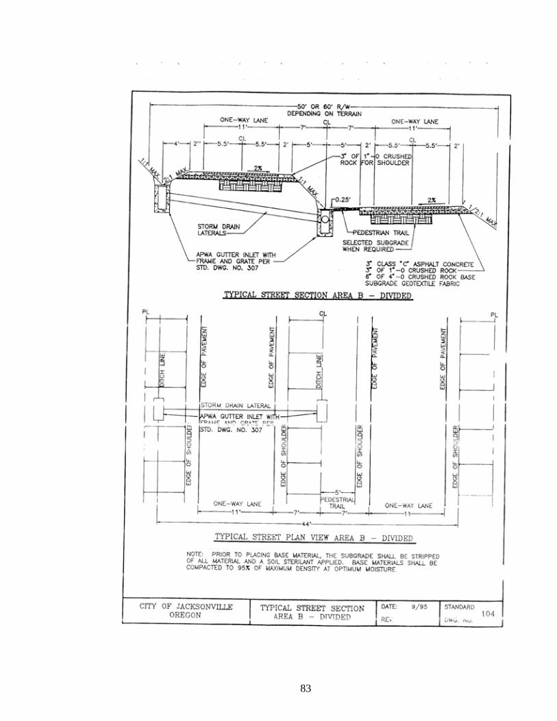
83

84

85

86
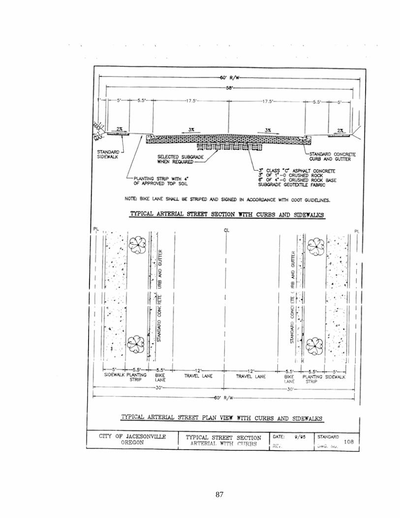
87

88

89

90
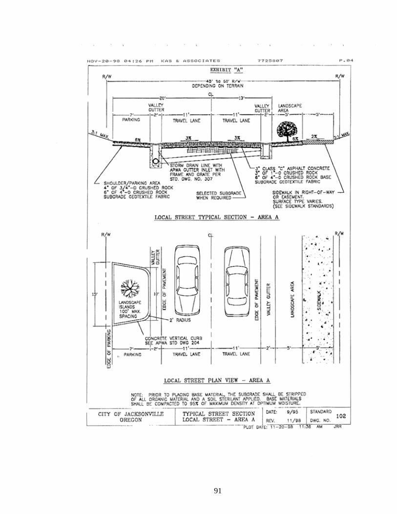
91

92
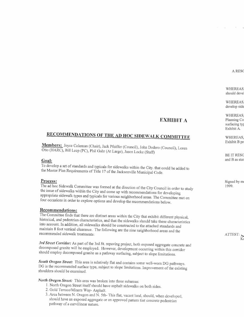
93

94

95
§ 17.48.040 OTHER PLAN REQUIREMENTS.
(A) All new development proposals shall provide a network of pedestrian and cycle paths, tracks and linkages that conform to the general routing concepts contained in Exhibit C. In order to provide a complete exercise system for our residents and an attraction for our visitors, bicycle and pedestrian paths shall tie into the Woodlands System, wherever possible, and shall be separated but interlace with each other through a tree-lined corridor. No development that would prohibit stream corridors from being utilized for trails in accordance with those concepts are allowed. Pedestrian facilities shall be constructed in conformance with City Council resolution containing standards and surface types. (Am. ORD 579, 3-4-08)
(B) All new development proposals shall establish, where possible, trails along non-urbanized sections of stream corridors, ensuring that stream ecology and any residences are protected. Preservation may also be accomplished through acquisition, easements or other means that secure flood plain areas for native trails, foot paths or as natural, aquatic and wildlife habitat preserves.
(C) Traffic generators such as schools, churches, or neighborhood shops within residential areas should be considered in the local circulation pattern and visitors should be directed to clearly marked parking areas. Where possible, hours of operation should be shifted to off-peak periods to avoid congestion.
(D) Access onto Cemetery Road shall be restricted to Cemetery use only due to topography and the gated historic nature of the road.

96

97
§ 17.48.050 GENERAL PLAN PROVISIONS.
(A) The design of the entrance sign, to be located in the unused area near the MID canal and the Royal Mobile Estates Bridge, is subject to a shared review process between the HARC and Planning Commission’s for mutual agreement.
(B) If adjacent property owners are agreeable, locate the entrance sign outside the Right-of-Way (ROW) in order to avoid all the ODOT breakaway standards.
(C) Bus stops/pullouts in the Gateway should be located in the ROW near the south end of the Motel, and generally across the Highway in front of the proposed assisted care facility on private property, if possible.
(D) A mid-block crosswalk should be located generally in front of the Financial Office (if accesses are consolidated).
(E) The Fifth and ‘G’ Street intersection should have four (4) crosswalks (connecting each corner) due to the ever-increasing mix of commercial/residential/school activity.
(F) The Fifth and Shafer Intersection should have three (3) crosswalks (across Shafer, the westerly private point of access, and the north side of the Highway portion of the intersection).
(G) All crosswalks should be striped rather than textured n this area of town.
(H) Pedestrians need to be invited to both existing and future businesses on the southeast side of the highway where masses of asphalt presently exist. However, that area should have a five (5’) foot surfacing to match the sidewalk across the highway rather a six (6’) foot width (from in front of Gary West Meat’s to the Motel).
(I) A petition should be filed with the State of Oregon to reduce highway speed through the Gateway to twenty-five (25) miles per hour (MPH).
(J) The concept of a tree-lined corridor outside the City should be forwarded as a recommendation to the State of Oregon and Jackson County.
(K) Tree plantings in the Gateway area should not be linear and uniform, but rather should be clustered. Clusters should be primarily incorporated as part of private development plans. An incentive program should be explored such as relief of certain fees of regulatory standards.
(L) At least six (6) tree clusters should be developed (three per side of road): 1. One on the westerly property near the intersection of Fifth and Shafer. 2. One on the vacant commercial property near the east leg of the Medford Irrigation District (MID) canal. 3. One on the Shafer Lane Right Of Way (ROW) north of the Motel. 4. One on the westerly property near the inside curve of Highway 238.

98
5. A small one on the westerly property approximately one hundred (100’) feet from
‘G’ Street. 6. One near the easterly property line approximately one hundred (100’) feet from “G’
Street. The clusters are not limited to these six (6) areas. Calling out specific tree types should be avoided on all but the City ROW cluster where Big Leaf Maple or other historically appropriate species should be planted if well separated from the road/sidewalk and root barrier/sub-surface planting techniques are used. Let the selections (deciduous & conifers) be made from the Community Forestry Plan.
(M) The design of the street light standards shall be selected by HARC. The four (4) corners of the intersections shall be lit to slow traffic. No other street furniture such as benches or waste cans, (other than at the bus stops an along the greenway), should be employed.
(N) Identify any specific opportunities for undergrounding and locations for utility conduits.
(O) Develop a conceptual special treatment plan for the southeast side of the bend in Fifth Street where three existing businesses currently have un-permitted parking that backs onto the Highway. Continue to refine the concept graphic into a detail design that will be adopted by Resolution. Consider offering some expanded signage incentives and parallel parking along Fifth Street, if a shared program is utilized, (this does not preclude the utilization of the code allowances for signage on the individual properties). A low landscape frontage treatment will make this area more attractive to residents and customers. The City shall solicit Oregon Department of Transportation’s (ODOT) approval for any parking in the excess ROW in this area.
(P) Accept the additional four (4’) foot of ROW that has been proposed for dedication on the southwest corner of the Shafer Lane intersection since it will be needed where sidewalk is required on both sides of Highway 238. A sidewalk is not required on the east side north of the Shafer Lane intersection, since this only leads to the orchard.
(Q) Promote the consolidation of the two private accesses on the northwest side of the Shafer/Fifth Street intersection through the elimination of the southerly gas station access in favor of its connection with a shared private access that creates a proper alignment with Shafer Lane.
(R) Strive to complete the Jackson Creek Greenway pedestrian connection up to the Royal Mobile Estates.
(S) Encourage ODOT to install a left lane into the Royal Mobile Estates for northbound traffic.

99
§ 17.48.060 SPECIFIC GATEWAY STANDARDS. (A) Circulation and Access Standards. 1. Street Standards, General. (a) Except for specific transportation facilities identified in the Gateway Plan
the following street dimensional standards shall apply for all development:
Street Types
Right-of-Way
Travel Lane Parking Bike lane Park Strip Side-walk
Major Street (North
5th)
60’ 12’ No Yes 6’ 6’ NW 5’ SE
Minor Street
(narrow) 40’ 10’ or 11’ 7’ One side No 6’ 5’
(easement)
Alleyway 24’ 8’ No No No No
2. Public Access way Standards. (a) Pedestrian access ways and greenways shall be provided as needed, to
supplement pedestrian routes along public streets. (b) Public street, driveway, loading areas and surface parking lot crossings shall
be clearly marked and dwell-designed. 3. Other. (a) Whether publicly or privately owned, an access way or greenway shall
conform to the section design specified for its functional classification and remain accessible to the public at all times.
(b) Pedestrian crossings of streets, driveways, surface parking lots and loading areas shall be designed to be consistent with the other provisions of this section.
4. Right-of-Way and Building Interface Design. (a) Sidewalks shall be designed with enough room to place pedestrian
amenities and street furniture out of the walking zone. (b) All streets shall incorporate pedestrian scale lighting at a level sufficient to
provide a safe walking environment.

100
5. On Site Pedestrian and Bicycle Circulation. (a) Maintain an attractive access route for pedestrian travel where a public
right-of-Way exists or has existed. (b) Reduce distances between destinations or activity areas such as public right
of way. (c) Provide an attractive, convenient pedestrian access way to building
entrances. (d) Bridge across barriers and obstacles by connecting pedestrian pathways
with clearly marked crossings and appropriate sidewalk design. (e) Integrate signage and lighting system that offer interest and safety for
pedestrians. (B) Sight Design Standards. 1. Respect for On-site features. (a) Adjustments shall be made during land division and site design to improve
the overall relationship of a development or an individual building to the surrounding context.
(b) Structures shall be clustered to preserve natural areas or to enhance solar exposure, for instance, rather than place in the center of each lot.
(c) Adjusting the massing of individual buildings shall be considered to preserve important views, benefiting new and existing occupants and surrounding neighborhoods.
2. Natural Features. (a) Buildings shall be sited to preserve significant or important trees. (b) Buildings shall be sited to avoid or lessen the impact of development on
environmentally critical areas such as stream corridors. 3. Parking and Vehicle Access. (a) Minimize number and width of driveways and curb cuts, and, when
possible, consolidate driveways. (b) There shall be no vehicle areas between the building and the street in
commercial zones. If a site has two frontages, this guideline applies to both frontages.
4. Lighting. (a) Pedestrian scale street lighting shall be provided along arterials. (b) Pedestrian street lights shall be no taller than twenty (20’) feet. (c) Additional Pedestrian-oriented site lighting including step lights, well lights and bollards are encouraged. (d) Fixture height and lighting levels shall be commensurate with their

101
intended use and function and shall assure compatibly with neighboring land uses. Baffles shall be incorporated to minimize glare and to focus lighting on its intended area. (e) Light poles shall not exceed twenty (20’) feet in height.
(f) Maximum lighting levels shall not exceed six (6’) foot candles at intersections or one and one-half (1.5’) foot-candles in parking areas.
(g) Metal-halide or lamps with similar color, temperature and efficiency ratings shall be used for general lighting at building exteriors, parking areas, and urban spaces. Sodium based lamp elements are not allowed.
(h) In addition to lighting streets, sidewalks, and public spaces, additional project lighting is encouraged to highlight and illuminate building entrances, landscaping, parks. Additional illumination promotes pedestrian safety and evening activity.
(i) Incorporate lighting into the design of a project so that it reinforces the pedestrian environment, provides continuity to an area.
5. Street Trees. At least six (6) tree clusters should be developed (three (3) per side of road):
(a) One on the westerly property near the intersection of Fifth St. and Shafer. (b) One on the vacant commercial property near the east leg of the Medford
Irrigation District (MID) canal. (c) One on the Shafer Lane Right Of Way (ROW) north of the Motel. (d) One on the westerly property near the inside curve of Hwy. 238. (e) A small one on the westerly property approximately one hundred (100’) feet
from ‘G’ Street. (f) One near the easterly property line approximately one hundred (100’) feet
from “G’ Street.
The Clusters are not limited to these six (6) areas. Tree spacing shall be determined upon the width of the tree crown. Tree species shall be chosen from the approved street tree list. 6. Service Areas.
All on-site service areas, loading zones and outdoor storage areas, waste storage, disposal facilities, transformer and utility vaults and similar activities shall be located in an area not visible from a street or urban space. If this is not possible, then the service area, loading zone, or storage area must be fully screened from public view. Prohibited screening includes chain-link fencing with or without slats. Acceptable screening includes:
(a) A masonry or wood enclosure incorporated into a building wall. (b) A solid hedge or other screening as approved.

102
§ 17.48.070 NORTH FIFTH STREET GUIDELINES General Guidelines. The following paragraphs describe general requirements that apply to all properties in the North Fifth Street Gateway. These guidelines set the tone and feeling that contribute to the unique character of the Gateway. When there is a conflict between the provisions of this section and other requirements of this title, the provisions of this section shall govern.
1. Maintain integrity of the two (2) existing historic buildings within the gateway area. 2. The rural/agricultural visual patterns just north of the entry to Jacksonville shall be
incorporated into the visual and structural qualities throughout the Jacksonville Gateway area.
3. The Gateway and associated street edge shall be strongly defined using an appropriate mix of approved large-scale street tree. These plantings shall be located outside the ROW while simultaneously being located as close to the right of way or sidewalk edge as reasonably allowed.
4. Small-scale vertical architectural elements, (e.g. piers, posts, columns), shall be located along portions of the street edge to strengthen the visual corridor, and enhance the verticality of the associated street areas. Any vertical elements shall be located outside the ROW.
5. Architectural elements such as bus stops and lighting standards shall be incorporated into the streetscape, further defining the Gateway/entry.
6. Miscellaneous items that could be used on private property to contribute to the character of the district include benches, landscaping, planter boxes, exterior lighting and grates.
7. Smaller buildings, (fifteen (15’) feet high or less), shall be located closer to the sidewalk and street edge, (within fifteen (15’) feet from the Right-of-Way edge). Larger buildings, (over fifteen (15’) feet high), shall be set back twenty-five (25’) feet from the Right-of-Way edge. Set back shall be proportional to height taking parking into consideration.
8. The architectural treatment of buildings within the Gateway area shall reflect rural structures in the Jacksonville vicinity using the following construction and design details:
(a) Farm compounds with a main structure surrounded by various size,
height, and type of outbuildings in close proximity to each other. The form, scale, massing, size and materials used shall draw from those associated with agricultural buildings.
(b) Mix of siding treatments for new and remodeled buildings shall be selected from rough textured wooden materials such as vertical plank, board & batten or shiplap siding with a lap exposure between six (6) and ten (10”) inches.
(c) Repeated arrangement of doors and windows in the facades of a building. (d) Vertically rectangular window openings using either one-over-one, two-
over-two or four-over-four divided light windows shall be used (e) Double or barn type doors.

103
(f) Architectural treatments may use rural structural features such as small
vernacular cottages, farmhouses, and sheds. (g) Porch elements with shed roofs or loading dock features shall be used for
building entryways. (h) Exterior finishes shall be natural and allowed to weather or use a color
range of shades from brown through gray. (i) Rural structural features such as water towers and barns.
9. The primary pedestrian entry into buildings or structures shall be from the main
street frontage. 10. Parking shall be to the side and rear of all buildings. 11. Buildings and parking areas shall be buffered from street-side view with appropriate
vegetation screening, inclusive of the recommended street tree plantings. Low enclosure walls of wooden-form poured concrete, dry-stacked sandstone rubble or random coursed mortared sandstone may be used in conjunction with landscaping.
(See: Exhibit A, pg. 104 - 106)

104
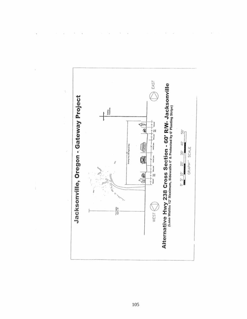
105

106

107
CHAPTER: 17.60: RESIDENTIAL GROWTH MANAGEMENT SYSTEM
Section
17.60.010 Findings and Purpose 17.60.020 Applicability 17.60.030 Residential Growth Management Effectuation 17.60.040 Residential Growth Allotment Established 17.60.050 Residential Growth Allotment Application 17.60.060 Filing Fee 17.60.070 Site Plan Committee Evaluation 17.60.080 Development Allotment Evaluation 17.60.090 Award of Development Allotments 17.60.100 Project Development Phase 17.60.110 Project Development Time Limit 17.60.120 Appeals: General
§ 17.60.010 FINDINGS AND PURPOSE. It is the finding of the Jacksonville City Council and hereby declared as a matter of public policy, as expressed in the Comprehensive Plan and applicable elements contained therein which expresses the need for careful, logical, sequential phasing and management of growth and development within the community, due to the local, state and nationally recognized significant historical and cultural heritage of the community, that such public policy shall be implemented by the effectuation of measures which manage and control the quality, quantity, distribution and rate of residential growth and development of the city. Therefore, this title is intended to:
1. Preserve, protect, enhance and perpetuate the unique national, state and local historical and cultural significance of Jacksonville.
2. Preserve the small town character of the community and to avoid unexpected “boom town” growth and development such as to cause an immediate and visible effect upon Jacksonville’s unique and distinctive qualities that communicate a sense of place.
3. Protect a history that is more visibly apparent than in most towns in the nation, since it is recognized nationally for having one of the finest continuums of brick buildings dating from the 1860’ and 1870’s and cultural center for all of southwest Oregon.
4. Retain Jacksonville’s unique identity and sense of place this is so visually apparent in its historical architectural features and natural, scenic surroundings.
5. Preserve the quality of life in the community. 6. Protect from rapid, uncontrolled growth the steep hillsides of the south and west
areas of the city which provide an effective, aesthetic, forested backdrop to the community.

108
7. Preserve and maintain the human scale and pedestrian orientation of the streets and buildings and the relative compactness of buildings in much of the commercial and residential sections, which physical attributes contribute to the quality of the social and cultural life in Jacksonville.
8. Protect the city from over-taxing its public services and facilities. 9. Insure the adequacy of city services and facilities within the limits of available
revenue resources; and allow for proper planning and programming of public capitol improvements.
10. Insure a balance of housing types and location to avoid an imbalance of development occurring primarily in one (1) or two (2), as opposed to all, sectors of the community.
11. Protect and enhance the city’s attraction to visitors and the support and stimulus To the economy thereby provided by promoting the historic, educational, cultural, economic and general welfare of the public through the preservation, restoration and protection of buildings, structures, and appurtenances; sites, places and elements of historic interest within the City of Jacksonville.
The Jacksonville City Council further finds that the purpose of this title is to implement the policies that the City of Jacksonville has established in the Comprehensive Plan. This purpose is to be accomplished by city control of the quality, quantity, distribution and rate of proposed residential growth and development on a year-to-year basis. § 17.60.020 APPLICABILTY. (A) Except for single-family residential lots lawfully created prior to the adoption of this title, this chapter and the provisions thereof shall apply to all residential development in the City of Jacksonville, including single-family, two-family and multiple-family residential developments. (B) No Residential developments subject to the provisions as herein provided shall be undertaken, and no building permits shall be issued in the City of Jacksonville, unless a development allotment has been obtained therefore in accordance with the provisions of this title. § 17.60.030 RESIDENTIAL GROWTH MANAGEMENT EFFECTUATION. (A) When the population of the City of Jacksonville exceeds five percent (5%) increase from the immediately preceding year population estimate, or exceeds the low population projections to the year 2000, as depicted upon following high and low population projection computer printout, as determined by the annual population estimates for July of each year by the Center for Population, Research and Census, Portland State University, the provisions of this title shall become into effect:
1. Upon determination of the city population on or before December 31, of each year, if it is found to exceed five percent (5%) increase from the preceding year, or to exceed the low population projection for that year, the city shall publish notice once in a newspaper of general circulation in the area and notify the Jackson County Planning and Development Department that the Residential Growth Management System is in effect.

109
(B) When the Residential Growth Management System is in effect, it shall apply to permits to build, construct, remodel or erect all residential developments pursuant to Section 17.60.020 with exceptions as noted. (C) Base year population adjustment:
1. It shall be the authority of the City Council, upon the recommendation of the Site Plan Committee and the Planning Commission, to readjust the base year population for high and low estimates provided by the Center for Population, Research and Census, and Portland State University. This may also include the readjustment of both high and low projections for the year 2000, based upon new or revised evidence of population characteristics from the Center for the Bureau of Census, Block Statistics.
§ 17.60.040 RESIDENTIAL GROWTH ALLOTMENT ESTABLISHED. (A) The City Council shall, upon the recommendation of the Planning Commission an dafter a legislative hearing pursuant to Section 17.60.030, establish residential growth allotments annually for the next three (3) subsequent years to, within that time period the order is called into effect, brig the city’s population within the limits established by Section 17.60.030, (A), to allow for allotments in excess of the low population projection for each subsequent year, but in no case shall such allotments be in excess of the high population projection for each subsequent year. (B) The City Council shall use as a general criterion for establishing the allotment, the goal of fairly meeting the housing needs of the city as expressed in the housing element of the Comprehensive Plan. This criterion is not exclusive and is meant to supplement, and not replace, the intent and purpose of this title. The more specific qualitative and quantitative standards and criteria as listed below in this chapter shall be utilized in the evaluation of each residential development allotment application submitted. The City Council shall adopt as findings, the data and information it received in establishing permit allotment approvals and denials. (C) The City Council shall determine, upon the recommendation of the Site Plan Committee and Planning Commission, the number of housing units which can be added to the city while meeting the population goal established in Section 17.60.030, (A). The number of housing units to be added shall be established as an annual allotment for each year within the three (3) year period. The units shall be allocated among the following categories and at the percentages listed for each:
Category Percentage
1. Single-family residential 75%
2. Multiple-family residential 25%
(including 2-family residential)
(D) Population to dwelling unit equivalency:

110
For the purpose of establishing permit allotments, based upon established population rates per household, the following formula shall be utilized to determine such allotments both for single-family and multiple-family residential units: 1. Development Allotment (persons) - Average, persons per dwelling unit = total dwelling unit allotment. 2. Total dwelling unit allotment x (0.75) = Total single-family dwelling unit allotment. 3. Total dwelling unit allotment x (0.25) = Total multiple-family dwelling unit allotment. § 17.60.050 RESIDENTIAL GROWTH ALLOTMENT APPLICATION. An application for a residential growth allotment shall be made to the City of Jacksonville on a form provided by the city. When the Residential Growth Management System is in effect, all applications for consideration of approval for the succeeding year shall be submitted on or before March 1 of the allotment year. No applications submitted thereafter will be considered for an allotment permit for that calendar year. Such application shall contain the following documents: 1. Site utilization map; including:
(a) Vicinity map to show the relationship of the surrounding areas and the city. (b) Topography. (c) Lot dimensions. (d) Street alignments depicting coordination with city street system. (e) Existing and proposed buildings, tees, and landscaping areas.
(f) Open space, bicycle paths and equestrian trails or pathways. 2. Preliminary architectural plans, showing: (a) Typical architectural elevations. (b) Types and numbers of dwelling units. (c) Proposed materials and colors of buildings. 3. Preliminary landscaping plans showing the general indication, location and type of
planting material. 4. Residential security schedule showing proposed locks and security devices on doors and windows, exterior lighting, etc. 5. Public facilities plan, showing:
(a) Needed public facilities to be provided, if any, such as critical linkages in the major street system, sewer and water lines. (b) Other essential public services and facilities as identified by Comprehensive
Plan, Capitol Improvement Program or special facilities plans.
6. Development schedule, showing: (a) Proposed calendar schedule of development including phasing, if any. (b) All applicable processes such as tentative and final subdivision plat,
conditional use permits, re-zoning, Site Plan Committee review, historical and architectural review and similar matters.

111
7. Financial information schedule showing financial information sufficient to enable the city to determine if the developer is capable of undertaking and completing the project if a development allotment is awarded. (This information can be submitted on a confidential basis to the city recorder). 8. Where applicable, applications for re-zoning, conditional use permit, etc., must also be filed. If allotments are not awarded, application and fees shall be returned. 9. Such other information as may be required by the city. § 17.60.060 FILING FEE. Each application shall be accompanied by a processing fee as established by resolution of the City Council. Pending the adoption of such resolution, the processing filing fee shall be thirty dollars ($30.00). Such fees shall not be returnable in the event that no development allotment is awarded. § 17.60.070 SITE PLAN COMMITTEE EVALUATION. (A) The Site Plan Committee shall review each application and determine whether or not the proposed development conforms to the City of Jacksonville Comprehensive Plan, including all elements thereof, and specifically the applicable implementing ordinance provisions. If the committee determines that the proposed development does not conform to the Comprehensive Plan or the applicable implementing ordinances, the application shall be rejected. The applicant shall be given a notice of such rejection within ten (10) days after the submission of the application. Such notice shall be given by the Site Plan Committee by mailing a notice to the applicant at the address as shown on the application. (B) Within ten (10) days after such notice is mailed, the applicant may appeal the decision of the Site Plan Committee to the City Council, by filing a written notice of appeal with the city recorder, who shall place the matter on the next agenda for a regular council meeting. The City Council shall consider the appeal at such regular meeting or may continue the matter at the applicant’s request, and shall either affirm the decision of the Site Plan Committee and reject the application on the basis of non-conformity with said Comprehensive Plan, reverse said decision by finding that the proposed development is in conformance with said Comprehensive Plan, or permit the applicant to modify the proposed development to bring it into conformity with said Comprehensive Plan. The decision of the City Council shall be final and conclusive. § 17.60.080 DEVELOPMENT ALLOTMENT EVALUATION. (A) Proposed developments found by the Site Plan Committee, Planning Commission or City Council to conform to the Jacksonville Comprehensive Plan, shall be evaluated and awarded points as hereinafter set forth by the Site Plan Committee. The Site Plan Committee shall be advisory to the Planning Commission and City Council regarding the Residential Growth Management System evaluation. (B) After the Residential Growth Management System is called into effect, each proposed development submitted on or before the filing deadline of March1, upon the appropriate application form containing all information as listed in Section 17.60.050, shall be examined for its relation to and
112
impact upon the local public facilities, services and purposes of this title as set forth in Section 17.60.010 by the Site Plan Committee and Historic and Architectural Review Commission. Items marked with an asterisk (*) shall be the jurisdiction of the Historic and Architectural Review Commission evaluation and point assignment for recommendation to the Planning Commission. If the application is found to be inadequately served by public or private facilities, the application shall be rejected. The developer shall be notified in writing of such deficiencies and an appeal may be filed with the City Council under the same procedures as set forth in Section 17.60.070. Examination o the application shall be considered on the basis of the following factors and related qualitative point system and scale, and each development’s final score will be represented by the percentage of points received versus the maximum number possible carried out to one one-thousandth (1/1000) of a percent: 1. The ability, condition and capacity of the municipal water system, or provision for a private water system, to provide for the needs of the proposed development without system extensions, unless the developer will consent to provide such extensions. (10 points) 2. The ability, condition and capacity of the sanitary sewer system, or provision for a private sewer system, to dispose of the wastes of the proposed development without system extensions, unless the developer will consent to provide such extensions. (10 points) 3. The ability, condition and capacity of storm drainage facilities to adequately dispose of the surface run-off of the p of the proposed development without system extensions beyond those which the developer will consent to provide. (10 points) 4. The proximity and ability of the Fire Department of the City of Jacksonville to provide fire protections according to acceptable response standards of the city without the necessity of establishing a new fire station or requiring the addition of major equipment to the existing station. (10 Points) 5. The proximity and capacity of the schools to absorb the children expected to inhabit a proposed development without necessitating additional classroom over-crowding. (10 Points) 6. The proximity, capacity, condition, and ability of major street linkages to provide for the transportation needs of the proposed development without
substantially altering existing traffic patterns or over-loading the existing street system, and the proximity and availability of other public facilities, (such as parks, playgrounds, etc.), to meet the additional demands for vital public services without extension of services and facilities beyond those provided by the developer. (10 Points)
*7. Architectural design quality as indicated by the architectural elevations of the proposed buildings judged in terms of architectural style, size, height, innovations and compatibility with the character of historical buildings or structures, (if any), adjoining or within the neighborhood. (20 points)
*8. Innovative site design quality as indicated by lot layout, orientation of dwelling unit(s) upon the lot(s), blending of construction to the natural landscape and topographical features, and similar site design considerations including solar access orientation. (20 points)
*9. Site and architectural design quality as indicated by the arrangement, amount and character of landscaping, screening and color of structures. (10 points)

113
*10. Site and architectural design quality as indicated by the arrangement of the site for efficiency of circulation, on and off-site traffic safety and privacy. (10 points)
11. The provision of public and/or private usable open space area which would include provision of pedestrian or bicycle pathways or, where applicable, extension of such pathways for public use as delineated in the Comprehensive Plan. (15 points)
12. The extent to which the proposed development accomplishes the goal for an orderly, logical and contiguous extension of existing development as opposed to “leap frog” development by being contiguous to urban development within the city limits. (15 points)
13. The provision of needed public facilities such as critical linkages in the major or minor street system, public open spaces, parks dedication or other vital public facilities. (15 points)
§ 17.60.090 AWARD OF DEVELOPMENT ALLOTMENTS. (A) If the requests for development allotment permits are less that the quota established by the City Council pursuant to Section 17.60.030, (A), then all permits shall be issued for that particular development category, (single-family and multiple-family residential). (B) If the requests for development allotment permits are greater than the quota established by the City Council pursuant to Section 17.60.030, (A), then the requests shall be processed in the following manner: 1. The Site Plan Committee and Historic and Architectural Review Commission
shall evaluate and award points to each request pursuant to Section 17.60.080, (B). Such evaluation shall be completed within thirty (30) days after the filing deadline for applications of March 1 and a recommendation forwarded to the Planning Commission of the development allotment evaluation and points awarded to each requested development application.
2. The Planning Commission shall review the recommendation of the Site Plan Committee and Historic and Architectural Review Commission, and following a public hearing on the matter, may amend or modify the recommendation, as it deems necessary. Following closure of such public hearing, the Planning Commission shall rank each request by priority according to the final qualitative
point award, (with permit applications having the highest number of points), the highest priority.
3. If the Planning Commission finds that there are an excess number of development allocations proposed to be awarded in one particular development category and/or priority area, the commission may transfer, by motion, such allocation awards to another category and/or priority area.
4. Prior to the issuance of any building permits on the basis of the development allocations awards granted by the Planning Commission, within fifteen (15) days following final action of the commission, the City Council, on its own motion, may review the actions of the Planning Commission. If the City Council deems it necessary, a public hearing may be set to consider amending, modifying or

114
reversing any decision of the Planning Commission pertaining to the development allocations.
5. Following City Council action, or, if no review of the Planning Commission decision is conducted by the council within the ten (10) day period following Planning Commission action, permits shall be awarded to developments according to priority. All permits possible under the residential growth allotment established shall be awarded.
6. At least one competition for development allocation permits shall be held each year the Residential Growth Management System is in effect.
7. Appeals: (a) Any decision of the Planning Commission relative to allotments for permits may be appealed to the City Council in writing within five (5) days of the decision of the commission. Action on the appeal by the City Council shall be final and conclusive following a public hearing on the matter.
§17.60.100 PROJECT DEVELOPMENT PHASING. (A) It is the prerogative of the Planning Commission to authorize the phasing and development of projects into developmental units for the purpose of granting one (1) or more phases for the current calendar year and to guarantee allocation of permits for the completion of said phases for the following two (2) calendar years allocation of permits. (B) The commission shall phase projects when the number of applicants exceeds the development allotment permit quota for that year, but which qualify in the quality point system evaluation. However, the commission may not guarantee more than sixty percent of available allotments available for the following two (2) calendar years in phasing projects. (C) Each phase of a project must constitute a logical developmental unit in itself including, but not limited to, adequate provision for sewer, water, storm drainage, transportation, recreational facilities, open space, etc. (D) The commission shall attempt in phasing projects to: 1. Fully utilize the development allocation quota established in Section 17.60.030, (A). 2. Grant the requests of the maximum number of applicants possible. § 17.60.110 PROJECT DEVELOPMENT TIME LIMIT. (A) A project for development which is awarded a development allocation permit while the provisions of this chapter are in effect shall have no more than one hundred twenty (120) days from issuance of said allocation permit to commence construction. (B) If, after one hundred twenty (120) days, it appears that substantial construction has not commenced, the Planning Commission shall hold a public hearing, giving due notice to parties of interest to such proceedings, to determine the facts in the matter. If, after the hearing, it appeared that

115
unavoidable delays have occurred in the project’s construction, the commission may extend the time period for an additional sixty (60) days. (C) If the time limit expires for a project, and no extension has been granted by the Planning Commission, the project development portion of the development allocation for that construction year shall be returned to the allotment quota and the next eligible development project in order of priority for the construction year under consideration, which submits a notice of agreement to proceed with construction and a reasonable, but expedited development schedule satisfactory to the Site Plan Committee, shall be awarded the revoked allotment(s). Upon such award, the new developer shall succeed to the rights and obligations of the original recipient. § 17.60.120 APPEALS: GENERAL. Any action of the Planning Commission in the administration of this chapter may be appealed to the City Council by an affected party. The affected party shall file notice of the appeal in writing containing the reason for such appeal with the city recorder within ten (10) days of the Planning Commission’s action.
116
CHAPTER 17.64: PLANNED UNIT DEVELOPMENT
Section
17.64.010 Purpose 17.64.015 Permitted uses 17.64.020 PUD Approval Process; Consolidated Applications Authorized 17.64.030 Application 17.64.040 Limitation on application 17.64.050 Hearing Procedure 17.64.060 Criteria for approval 17.64.070 Planning commission action 17.64.080 Deviations to be authorized 17.64.090 Common Elements 17.64.100 Postponed Preliminary PUD Plan Approval for Building Architecture 17.64.110 Engineering Construction Plans 17.64.120 Approval of Final PUD Plan; Approval Criteria 17.64.130 Building Permits; Development and Operation of a PUD 17.64.140 Revision of a Preliminary or Final PUD Plan 17.64.150 Termination of a PUD
§ 17.64.010 PURPOSE.
(A) The purpose of the planned unit development approach is to:
1. Promote creative and imaginative design for urban development in a way that is
more compatible with the natural topography. 2. Promote the preservation of important natural features, view sheds, and scenic
qualities of the land. 3. Promote a mixture of housing types. 4. Promote a more economic and efficient use of urbanizable land while integrating
with the surrounding neighborhood and not compromising the public health, safety or general welfare.
5. Promote clustering of housing to preserve open space, historic resources and limit the amount of key facilities or infrastructure to service the development.
6. Promote a mixture of land use types that are thoughtfully planned and integrated. 7. Promote the development, public utilization and appropriate maintenance of open
spaces and other elements intended for common use and ownership. 8. Provide overall "development concepts" that are compatible to the City's National
Landmark status through encouraging differentiation. Jacksonville's character is to a large extent defined by its uniqueness, differentiation abounds, from street to street, from house to house. Structural character changes in size, height, shape, roof configurations, setbacks, spacing, streetscapes, and material textures occur frequently. The compact nature of Jacksonville generally creates less distinct divisions, with new and old resources intermingling city-wide.

117
9. Promote the use of energy-efficient, sustainable, development.
10. Promote construction of pedestrian ways including internal pedestrian circulation. (Ord. 584, passed 12-2-2008)
(B) In the “PUD” zone, “PUD – 0.5, or “PUD – 1” zones, permitted uses are single-
family residential housing; non-profit and governmental structures and uses such as libraries and parks (but not including storage or repair yards); churches; public, private and parochial school and their ancillary uses. In the “Border PUD”, “Border PUD – 0.5”, or “Border – PUD - 1” (B-PUD) zones, all of the above uses, along with townhouses, multi-family dwellings and manufactured dwelling parks in accordance with Chapter 17.44 are permitted in order to encourage clustering to preserve resource trees, setbacks, connectivity options, natural topography, and view sheds. These uses are subject to the PUD approval process and criteria below. Where the zoning designation is specifically "PUD” or “Border PUD”, the density is 5.5 units per acre. Where the zoning designation is specifically “PUD – 0.5” or “Border PUD – 0.5”, the density is 2 units per acre. Where the zoning designation is specifically “PUD – 1” or “Border PUD – 1”, the density is 1 unit per acre. (ORD. 547, passed 5-17-2005)
(C) If a property within the PUD zoning designation is less than one (1) acre in size, the applicant may elect to utilize the provisions of Chapter 17.20, Single-Family Residential District based upon a minimum lot size of eight thousand (8,000’) square. § 17.64.015 PERMITTED USES
(A) In the “PUD” zone, permitted uses are single-family residential housing; non-profit and governmental structures and uses such as libraries and parks (but not including storage or repair yards); churches; public, private and parochial school and their ancillary uses.
(B) In the “Border PUD”” (B-PUD) zones, all of the above uses, along with townhouses,
multi-family dwellings and manufactured dwelling parks in accordance with Chapter 17.44 are permitted in order to encourage clustering to preserve resource trees, setbacks, connectivity options, natural topography, and view sheds. These uses are subject to the PUD approval process and criteria below:
1. Where the zoning designation is specifically "PUD", the density is five and one half (5.5) units per acre. 2. Where the zoning designation is specifically “Border PUD – 2”, the density is two (2) units per acre. 3. Where the zoning designation is specifically “Border PUD – 1”, the density is one
(1) unit per acre. 4. Where the zoning designation is specifically "Border PUD – 4" the density is four
(4) units per acre.
(C) If a property within the “PUD” zoning designation is less than two (2) acres in size, the

118
applicant may elect to utilize the provisions of Chapter 17.20, Single-Family Residential District based upon a minimum lot size of eight thousand (8,000’) square feet.
(D) If a property within the “Border PUD-4” zoning designation is less than two (2) acres in
size, the applicant shall utilize the provisions of Chapter 17.20, Single-Family Residential District based upon a minimum lot size of ten thousand (10,000’) square feet.(Ord. 584, passed 12-2-2008) § 17.64.020 PUD APPROVAL PROCESS; CONSOLIDATED APPLICATIONS AUTHORIZED. Approval of a PUD by the Planning commission shall be a two-step process involving approval of a Preliminary PUD Plan as the first step and approval of a Final PUD Plan as the second step. Except applications for major and minor comprehensive plan amendments and annexations, applications for development permits and other planning actions may be consolidated with an application for a Preliminary PUD Plan. Where use is made of the planned unit development process as provided in this chapter, no building or other permit shall be issued for such development or part thereof until the planning commission has approved said development. §17.64.030 APPLICATION. The owner or his agent may make application for planned unit development approval by filing an application with the city recorder. The application shall be accompanied by the following:
(A) A filing fee in an amount established by general resolution of the city council. No part of the fee shall be refundable.
(B) A current assessor's map with the boundaries of the proposed PUD identified.
(C) Preliminary Plan. All applications shall be accompanied by a general development plan (12 copies) prepared in accordance with Chapter 18.02. Additionally, such plans shall include preliminary plans for the provision of public access, water and sanitary sewer service and a proposal for the PUD's operative Covenants, Codes, and Restrictions (CC&Rs). The applicant shall also submit one copy of the Preliminary PUD Plan which has been reduced to a size suitable for photocopy reproduction.
If a tentative plan for a land division is submitted concurrently with a Preliminary PUD Plan,
the Preliminary PUD Plan and tentative plan shall be on separate sheets, with the tentative plan submitted in accordance with the application requirements of Chapter 16.12.
Approval of architectural plans for proposed buildings shall be referred to HARC for recommendations to the Planning Commission. An applicant for a Preliminary PUD Plan may postpone the submission and approval of architectural plans for proposed building and have such plans approved by HARC as a separate matter at a later time after the Preliminary and Final PUD Plan has been approved.

119
When the approval of architectural plans for buildings has been postponed, the Preliminary PUD Plan shall show the footprint of planned buildings in conceptual form and indicate their approximate height(s). Such building envelopes shall reasonably anticipate and separately define the maximum extent of the footprint for each building in the PUD. (D) A narrative description of the PUD which shall cover the following:
1. The nature, planned use, future ownership and method of perpetual maintenance of access ways and land to be left in natural or developed open space or which is
otherwise to be held in common ownership. 2. A listing of all deviations from the strict provisions of this Code by citing each
provision of the Code to be deviated from, followed by a brief explanation which covers the nature and extent of the deviation.
3. A proposed development schedule which indicates the approximate date when construction of the PUD is expected to begin and end. If the PUD will be developed in phases, the development schedule for each phase shall be keyed to a plan that indicates PUD phasing boundaries.
4. Such other pertinent information shall be included as may be considered necessary by the planning commission to make a determination that the contemplated arrangement or use makes it necessary and desirable to adopt regulations and requirements differing from those ordinarily applicable under this chapter.
(E) Written findings of fact and conclusions of law which address the approval criteria.
(F) The names and mailing addresses of the owners of property which are located within two
hundred (200’) feet of the exterior boundary of the whole PUD. The names and mailing addresses shall be typed on mailing labels. § 17.64.040 LIMITATION ON APPLICATION. No application shall be accepted for a use which will require a change of zoning district, unless said application is accompanied by an application for a zoning amendment as set forth in Chapter 17.108. § 17.64.050 HEARING PROCEDURE. A Planned Unit Development is a limited land use decision and shall be conducted in accordance with ORS 197.195 excepting that the Planning Commission may take verbal testimony. Pursuant to ORS 197.195, only those submitting written testimony during the fourteen (14) day comment period shall have the right to appeal said decision. § 17.64.060 CRITERIA FOR APPROVAL. In granting approval for a planned unit development, the commission shall make its decision based on the following:

120
(A) The applicant has, through investigation, planning and programming, demonstrated the soundness of his proposal, the fact that it will result in a safe, functional and attractive development, and his ability to carry out the project as proposed.
(B) The proposal conforms with all specific Master Planning requirements found in Chapter
17.48 that are relevant to the property or properties upon which that development proposal is located or to the off-site facilities and services which are affected by that the proposal, and all implementing ordinances of the city in terms of location and general development standards, except those for which a specific deviation has been approved under Section 17.64.080.
(C) The project shall accrue benefits to the city and the general public in accordance with
Section 17.64.080(F) sufficient to offset any requested deviations to the zoning district.
(D) The project will satisfactorily take care of the traffic it generates by means of adequate off-street parking, access points and additional street rights-of-way improvements.
(E) The project will be compatible with the adjacent natural environment and resource areas,
and shall compliment the character of the area.
(F) The property is or can be supplied at the time of development with the following types of public facilities that are determined to be sufficient in their condition and capacity to support development of the property as anticipated by the PUD:
1. Public sanitary sewerage collection facilities 2. Public domestic water distribution facilities 3. Storm drainage facilities 4. Public Streets 5. Parks and Recreational facilities
In instances where the Planning Commission determines that there is insufficient public
facility capacity to support the development of a whole PUD project, nothing in this criterion shall prevent the approval of early phase of a PUD which can be supplied with adequate public facilities.
(G) In the case of proposed commercial developments, that such development is needed at the
proposed location to provide adequate commercial facilities of the type proposed; that traffic congestion will not likely be created by the proposed center, or will be obviated by presently proposed improvements and by demonstrable provisions in the plan for proper entrances and exits, and by internal provisions for traffic and parking; that such development will be an attractive and efficient center which will fit harmoniously into and will have minimal adverse effects upon the adjacent or surrounding development.
(H) The proposal has met all purpose objectives in 17.64.010A.
(I) Developments shall be designed to provide pedestrian and bicycle access and link with
existing pathways. (J) Historical designs such as detached garages to the rear of the residence shall be
encouraged. If an alley is available, it shall service the detached garage, if traffic impacts on other

121
properties adjacent to the alley can be mitigated. If lot size, shape, topography, or traffic circumstances prohibit such relationships or render them impractical, attached garages may be permitted provided that the garage is located at least ten (10’) feet behind the front wall of the house. (Ord. 584, passed 12-2-2008)
§ 17.64.070 PLANNING COMMISSION ACTION.
(A) The planning commission shall act upon the application within one hundred and twenty (120) days after the application is deemed complete, excluding such time as may be required to complete any necessary zoning amendment. In taking action, the commission may approve unconditionally, approve with conditions, or deny an application as submitted. Any planned unit development as authorized shall be subject to all conditions imposed, and shall be accepted from the other provisions of this title only to the extent specified in said authorization.
Any approval of a planned unit development granted hereunder shall lapse and become
void unless, within twelve (12) months after the final granting of approval, or within such other period of time as may be stipulated by the planning commission as a condition of such approval, construction of the buildings or structures involved in the development has begun and has been diligently pursued. The planning commission may further impose other conditions limiting the time within which the development of portions thereof must be completed.
(B) The decision of the planning commission shall be final unless it is appealed to the city
council according to the procedures set forth in Chapter 17.112. § 17.64.080 DEVIATIONS AND BONUSES TO BE AUTHORIZED. The planning commission may authorize the design and approval of PUD's which deviate from the strict standards of this Code, provided that no deviations shall be permitted from the criteria contained in Section 17.64.060. It is further provided that the nature and extent of potential Code deviations shall be limited and pertain to the limitations, restrictions and design standards which are listed below:
(A) Size, dimension, location, position and coverage of lots.
(B) Location, size, height, yards and setbacks for buildings and other structures.
(C) Off-street vehicle parking and loading.
(D) Lot frontage, access, buffer yards and agricultural buffering.
(E) Private streets with respect to length, width, intersection standards, curve radii,
turnarounds, easements, street lighting, sidewalks, curbs and driveway approaches for streets within the PUD, provided they allow for adequate fire access. However, it is further provided that any deviations from the standards adopted in this Code shall be of an equivalent or better structural quality with respect the amount, quality and installation of

122
construction materials. It is also provided that when deviations are proposed for the design of streets, which the City Engineer shall have sole discretion whether said streets will be accepted as dedicated city streets or shall be held in private ownership and such determination shall be made at the time the Preliminary PUD Plan is approved. In no instance shall this section be used to deviate from the standards of this Code which apply to collector or arterial streets whether such streets occur adjacent to or within the PUD.
(F) At the Planning Commission’s discretion, the overall residential housing density for the
entire portion of the PUD which is devoted to residential uses may be increased by not more than thirty-five percent over the maximum density allowed in the underlying zone. Density bonus credits shall be applied in four (4%) percent increments for each of the following bonus standards:
1. All homes in the PUD shall meet US Green Buildings Council LEED (Leadership in Energy and Environmental) for Homes “Silver” Standards for green homes. (Additional bonus available for each LEEDS level met above “Silver”. Potential for a total of 3 bonus credits)
2. Fifteen percent (15%) of the homes are less than thirteen thousand (1,300’) square feet in gross floor area.
3. Twenty-five percent (25%) of construction materials shall originate from recycled materials.
4. Fifty percent (50%) of the average energy usage of the project shall be supplemented through the use of non-fossil fuel energy generation or fuel collected onsite. Two additional bonus credits may be available for each additional twenty-five percent (25%) of supplemental energy produced. Energy may be stored, used onsite and/or sold back to utilities.
5. The project shall receive a bonus credit for every thirty-five (35’) linear feet of riparian bank restoration per proposed dwelling unit (a 10 unit PUD would have to provide three hundred - fifty (350’) feet of one sided stream bank restoration).
(a) Restoration may be on public or private land (including off project site) and
is subject to mutual agreement between property and project owners and must be in the City of Jacksonville on Daisy or Jackson Creek.
(b) Riparian restoration areas shall be identified by the city engineer as “in need”.
(c) Restoration plan shall be approved with the PUD application and implemented within one (1) year of the first permit issued.
(d) Maximum of three (3) bonus credits.
(G) One (1) or more additional uses may be approved without the need to comply with the conditional use permit process or other criteria as part of the PUD provided that the amount of land devoted to uses other than those permitted outright in the underlying zone shall not exceed twenty percent (20%) of the gross acreage of the entire PUD and Criteria for Approval 17.64.060 (E) is satisfied. The percentage of land within the PUD allowed for other uses shall be computed by multiplying the gross area of the PUD by a factor of .2 and rounding the result down to the nearest whole number (Ord. 584, passed 12-2-2008)

123
§ 17.64.090 COMMON ELEMENTS. Where a PUD has open spaces, parking areas or other elements to be owned or maintained in common by the owners or future owners of land or improvements within the PUD, the Final PUD Plan shall not be approved and in no event shall any lot or unit be sold or conveyed until the PUD has been found to comply with the following requirements, as applicable:
1. If the PUD is a planned community under ORS Chapter 94, the declaration and plat for the planned community shall be submitted with the Final PUD Plan for approval by the Planning Commission before being recorded in the official records of Jackson County.
2. If the PUD is a condominium under ORS Chapter 100, the declaration and plat for the condominium shall have been recorded in the official records of Jackson County and a copy of the recorded declaration and plat shall be submitted with the Final PUD Plan. A condominium declaration and plat that has been approved by the Oregon Real Estate Commissioner and recorded in the official records of Jackson County is not required to be reviewed and approved by the Planning Commission and the Planning Commission shall have no authority under this Subsection to require changes thereto.
3. If the PUD contains elements intended for common ownership but ORS Chapters 94 and 100 do not apply, there shall be appropriate legal documents which assure that the common elements will be improved and perpetually maintained for their intended purposes. The legal documents in such instance shall be submitted to the Planning Commission for approval as part of the Final PUD Plan before being recorded in the official records of Jackson County.
4. When a PUD is proposed to be developed in phases, the phased provision of improved common elements shall be roughly proportional with the development of housing and other elements intended for private ownership. Nothing in this Subsection shall prevent the provision of improved common elements at a rate that is proportionally greater than the development of housing and other elements intended for private ownership.
5. Land shown on the Final Development Plan as a common element shall be conveyed
under one of the following options:
(a) To a public entity which shall agree in writing to perpetually maintain the common element(s) being conveyed.
(b) To an association of owners created pursuant to ORS Chapters 94 and 100 or as otherwise created under Subsection 17.64.090(3), in which instance the City shall be made a party to the legal document which establishes the association and such document shall provide that the association cannot be terminated or discontinued without the City's prior consent, and that the City may enforce any and all of its provisions.

124
§ 17.64.100 POSTPONED ARCHITECTURAL APPROVAL AND FINAL PUD PLAN APPROVAL When the approval of architectural plans for buildings in the PUD has been postponed under Subsection 17.64.030(C): 1. The Final PUD Plan may be approved if the architecture of buildings and/or
individual review of each structure at a later time have been approved by the Non-conforming.
2. At the discretion of the Planning Commission, the approval of architectural plans for buildings can occur as a one-step procedure when combined with the submittal of a Final PUD Plan which incorporates the building(s) and the landscaping and other site improvements which surround the building(s).
§ 17.64.110 ENGINEERING CONSTRUCTION PLANS. Engineering construction plans, profiles, details and specifications for all public facility and utility improvements shall be prepared by a qualified engineer registered in Oregon. The required engineering plans shall be submitted to and approved by the City before the start of construction. Unless specifically authorized by the Planning Commission at the time of Preliminary PUD Plan approval, all public facilities and utilities shall be designed and constructed in accordance with the standards and procedures of the City or other public entity to which ownership of said facilities or utilities will be conveyed. The procedures for engineering design, plan approval and inspection shall in all respects be the same as for land divisions under this Code. § 17.64.120 APPROVAL OF FINAL PLANNED UNIT DEVELOPMENT (PUD) PLAN; APPROVAL CRITERIA. The following provisions shall govern the submittal and approval of a Final PUD Plan:
A. Filing Requirements: Time Extensions: Within eighteen (18) months following final approval by the Planning Commission of the Preliminary PUD Plan, the applicant shall file a Final PUD Plan. The Final PUD Plan shall contain in final form all information and materials required by Section 17.64.030 unless certain items are waived by the Planner. However, there shall be no burden to demonstrate compliance with the criteria in Subsection 17.64.060 and no findings of fact and conclusions of law for these criteria are required in order for the Planning Department to approve a Final PUD Plan. As appropriate, the Final PUD Plan shall incorporate all conditions imposed by the Planning Commission at the time the Preliminary PUD Plan was approved. In its sole discretion and upon the written request by an applicant, the Planning Commission may extend the time for filing a Final PUD Plan for one additional twelve (12) month period or such lesser period as may be established by the Planning Commission.
125
(Ord. 584, passed 12-2-2008) B. Phased PUD: Time Limit Between Phases: The Final PUD Plan may be submitted for the
entire project or on a phase-by-phase basis consistent with the approved Preliminary PUD Plan. If a Preliminary PUD Plan was not approved as a phased project, nothing in this Subsection shall prevent the Planning Commission from approving a Final PUD Plan in phases provided that the Final PUD Plan complies with all other requirements of this Chapter. If the Planning Commission approves a Final PUD Plan for the first phase of a PUD having approved multiple phases, such approval shall perfect the applicant's rights under this Section to complete subsequent future phases. However, it is further provided that after Final PUD Plan approval for the first phase and for each successive phase thereafter, no more than five (5) years shall elapse between the approvals of phases. If more than five (5) years pass between the Final PUD Plan approval of any two (2) PUD phases, the Planning Commission may, without consent of the owners of the PUD, initiate action to terminate undeveloped portions of the PUD under Subsection 17.64.150(2). Nothing in this Subsection shall prohibit or limit the ability of the Planning Commission to establish time periods within which substantial construction of a PUD or any phase thereof is required to occur after a Final PUD Plan has been approved.
C. Final Plat for Land Division: Application for the approval of a Final PUD Plan may occur
before, after or concurrent with the approval of a final plat for a land division by the City Planner. However, it is further provided that no building permits shall be issued by the City and no buildings intended for human occupancy shall be constructed and no lot shall be sold until the Final PUD Plan has been approved by the Planning Commission.
D. Final PUD Plan Approval Criteria: A Final PUD Plan shall be approved by City Staff as an administrative process if it is concluded that compliance exists with each of the following criteria:
1. Provisions for the establishment and maintenance of elements to be held in common
ownership, if any, have or will comply with the standards in Section 17.64.080. 2. The Final PUD Plan is substantially consistent with Preliminary PUD Plan and the
conditions, if any, which were attached by the Planning Commission to the approval of the Preliminary PUD Plan. An applicant may seek written clarification from the Planner or Planning Commission regarding whether any anticipated differences between the Preliminary and Final PUD Plans meet the test of being substantially consistent. In no instance shall a Final PUD Plan be approved if inconsistencies with the approved Preliminary PUD Plan exist in any of the ways listed below and when such inconsistencies are found to occur, these shall result in the need to approve a revision to the approved Preliminary PUD Plan.
(a) The exterior boundaries of the PUD shall not change except for slight
deviations which are the result of correcting boundary errors or inconsistencies that are found to exist at the time the PUD property is surveyed.

126
(b) The number of housing units shall not be increased or decreased by more than two percent (2%).
(c) There are new deviations to provisions of this Code which were not approved by the Planning Commission as part of the Preliminary PUD Plan.
(Ord. 547, passed 5-17-2005, Am. Ord. 584, passed 12-2-2008) § 17.64.130 BUILDING PERMITS: DEVELOPMENT AND OPERATION OF A PUD.
All building and construction plans submitted for the purpose of obtaining building and other site improvement permits shall be consistent with the approved Final PUD Plan. In addition to other provisions of the Jacksonville Municipal Code and law, the City shall have authority under this
Section to ensure the successful completion of all public improvements. The development and
operation of the PUD shall conform in all respects with the approved Final PUD Plan. § 17.64.140 REVISION OF A PRELIMINARY OR FINAL PUD PLAN.
The revision of a Preliminary or Final PUD Plan shall follow the same procedures required for initial approval, provided that:
(A) For changes deemed by the Planner to be minor, the Planner shall exercise appropriate discretion to limit and waive the submittal of any of the required filing materials that are deemed to be excessive, repetitive or unnecessary based upon the scope and nature of the proposed PUD revisions.
(B) At the sole discretion of the Planner, revisions to an approved PUD Plan may be
consolidated into a single procedure, the effect of which will be the approval of both a Preliminary PUD Plan and Final PUD Plan.
(C) The burden of proof and supporting findings of fact and conclusions of law for the criteria
shall be strictly limited to the specific nature and magnitude of the change. § 17.64.150 TERMINATION OF A PUD.
A PUD may be terminated by action of the Planning Commission subject to the following procedures: (A) If substantial construction or development of the PUD has not occurred or if no lots or units therein have been sold, the PUD may be terminated by filing with the City a written petition signed by the owner or owners who control a majority interest in the land covered by the approved PUD. Upon receipt of a petition submitted by the PUD owners, the Planning Commission shall consider the matter in open meeting and shall declare the PUD terminated. The Planning Commission's termination of a PUD shall be evidenced by a Final Order declaring the same and after the Final Order is signed the PUD shall be terminated and previous PUD Plan approvals shall be considered void and of no further effect. Termination of a PUD shall in no way affect other land use actions taken by the City which concern the PUD property.

127
(B) If substantial construction or development of the PUD has occurred or if lots or units within the PUD have been sold, the PUD may be terminated by filing with the city a written petition signed by the owner or owners who control a majority interest in the land covered by the approved PUD. Upon receipt of the petition, the Planning Commission shall give public notice of the proposed PUD termination and conduct a public hearing on the matter. The Planning Commission shall declare the PUD terminated if it concludes that the termination will not produce greater than minimal harm to the public health, safety or general welfare. The Planning Commission's termination of a PUD shall be evidenced by a Final Order declaring the same and after the Final Order is signed the PUD shall be terminated and previous PUD Plan approvals shall be considered void and of no further effect. Termination of a PUD shall in no way affect other land use actions taken by the City which concern the PUD property.

128
CHAPTER 17.72: HOME OCCUPATIONS
Section
17.72.010 Purpose and scope 17.72.020 Permit required 17.72.030 Criteria 17.72.040 Exclusions 17.72.050 Revocation 17.72.060 Appeal 17.72.070 Existing uses
§ 17.72.010 PURPOSE AND SCOPE. The intent of the home occupation permit for residential zones is to provide for a limited low-impact business activity which is conducted in such a manner that the residential character of the building and the neighborhood is preserved. It is intended that granting this privilege would be the exception rather than the rule relative to the variety of activities requesting a permit. The permit shall not be transferable and the privileges it grants shall be limited to the person named in the permit and to the location and activity for which it was issued. § 17.72.020 PERMIT REQUIRED. The city recorder, or his/her designate, shall issue a home occupation permit only if, he/she finds that all of the following criteria are and will be met by the individual applicant. The permit may include conditions setting an expiration date, requiring periodic review and renewal, requiring the applicant to sign an acknowledgment of the conditions, or other conditions specifically dealing with the property use involved, where such conditions are found to be reasonably necessary to maintain the criteria herein mentioned. By making application for a home occupation permit, the applicant shall recognize and understand that because a business may be permitted to be conducted within the home or garage, the applicant may be required to have the home inspected by the building inspector, fire inspector, or a representative of any other department which may have authority or an interest in the health and safety of the occupants, customers, or the surrounding residents. Upon the presentation of proper credentials, the applicant shall agree to any and all reasonable inspections. § 17.72.030 CRITERIA. The proposal must conform to the following standards and criteria:
(A) The activity must be conducted entirely within the dwelling in question or garage. (B) The activity must be conducted only by members of the family occupying the dwelling.

129
(C) The outward residential appearance of all buildings must be preserved. (D) Not more than twenty-five percent (25%) of the floor area of any floor of the individual
dwelling unit may be utilized for the intended purposes. (E) Merchandising or sale of commodities may be conducted on the premises by
telecommunications or mail-order. (F) On-site storage of hazardous materials (including toxic, explosive, noxious, combustible or
flammable as determined by the Fire Chief) beyond that normally incidental to residential use is prohibited.
(G) A sign may be maintained in conjunction with the home occupation activity, provided it is
no greater than one (1’) square foot in area and placed flat against the building containing the activity. (H) No increase in traffic may be expected other than that attributed to normal residential
usage. (I) There shall be no emission of odorous, toxic, noxious matter nor any use causing electrical
or telecommunication interference, vibration, noise, heat or glare in such quantities as to be readily detectable at any point along or outside property lines of a home occupation so as to produce a public nuisance or hazard.
(J) If the permit is granted, the foregoing criteria shall be deemed conditions of the permit. (K) Child care centers must satisfy the requirements of Section 17.92.010.
§ 17.72.040 EXCLUSIONS. Home occupation permits shall not be issued for any of the following:
(A) Beauty shops.
(B) Barber shops.
(C) Kindergartens.
(D) Horticultural Nurseries.
§ 17.72.050 REVOCATION. The permit may be revoked by the city recorder for a violation of any conditions above imposed or authorized, but the city recorder, before revoking a permit, shall give the permittee reasonable notice and an opportunity to be heard.

130
§ 17.72.060 APPEAL. Persons within two hundred (200’) feet of the subject property shall be notified of any permit approval and if a request for a hearing is received within ten (10) days of a postmark notice, the matter shall be referred to the Planning Commission for a final decision. § 17.72.070 EXISTING USES. Persons engaged in home occupations lawfully in existence on residentially zoned premises on the effective date of the adoption of the ordinance codified in this title may continue to thus operate but shall be required to secure a permit hereunder, and any such activity, use or accessory sign, device or structure, or part thereof, which does not conform to this chapter shall not be permitted to expand or enlarge and shall be removed or terminated upon the following:
(A) Change of use or ownership of the premises. (B) Written complaint of adjacent property owners, after due notice and hearing if the city
recorder finds that the interference with the use and enjoyment of the neighboring premises is such as to defeat the purposes of this title.

131
CHAPTER 17.76: NON-CONFORMING USES AND STRUCTURES Section
17.76.010 Non-conforming uses 17.76.020 Non-conforming structures
§ 17.76.010 NON-CONFORMING USES.
A use lawfully occupying a structure or site on the effective date of the ordinance codified in this title or of amendments thereto, which does not conform to the use regulations for the district in which it is located, shall be deemed to be a non-conforming use and may be continued subject to the following regulations:
(A) Routine maintenance and repairs may be performed on structures or sites, the use of which is non-conforming.
(B) No structure, the use of which is non-conforming, shall be moved, altered or enlarged
unless required by law or unless the moving, alteration or enlargement will result in the elimination of the non-conforming use.
(C) No structure partially occupied by a non-conforming use shall be moved, altered or
enlarged in such a way as to permit the enlargement of the space occupied by the non-conforming use. (D) The planning commission may grant an application for a change of use, filed in accordance
with the provisions of Chapter 17.104, if, on the basis of the application and the evidence submitted, they make the following findings:
1. That the proposed use is classified in a more restrictive category than the existing or
preexisting use by the district regulations of this title. The classifications of the non-conforming use shall be determined on the basis of the district in which it is first permitted, provided that a conditional use shall be deemed to be in a less restrictive district than a permitted use in the same district.
2. That the proposed use will not more adversely affect the character of the district in which it is proposed to be located than the existing or preexisting use.
3. That the change of use will not result in the enlargement of the space occupied by a non-conforming use, except that a non-conforming use of a building may be
extended throughout those parts of a building which were designed or arranged for such use prior to the date when such use of the building became non-conforming, provided that no structural alteration except those required by law are made.
If a non-conforming use has been changed to a conforming use, or if the non-conforming use of a building, structure or premises ceases for a period of six (6) months or more, said use shall be considered abandoned, and said building structure or premises shall there after be used only for use permitted as a matter of right or as conditional uses in the district in which it is located.
132
§ 17.76.020 NON-CONFORMING STRUCTURES.
A structure lawfully occupying a site on the effective date of the ordinance codified in this title or of amendments thereto, which does not conform to the regulations for the district in which it is located, shall be deemed to be a non-conforming structure and may be continued subject to the following regulations:
(A) Routine maintenance and repairs may be performed on the non-conforming structure. (B) No non-conforming structure shall be moved, extended, or enlarged unless required by law
or unless the moving, extension or enlargement will result in the elimination of the nonconformance or will not increase the footprint or height in the area of non-conformance, such as a riparian setback.
(C) A structure which was lawful by reason of a limited use permit or variance may be allowed
on the terms of the original permit or variance granted and subject to all limitations under which the permit or variance was awarded.
(D) Should there be extenuating circumstances not provided for by these criteria, a variance
process will be required.

133
CHAPTER 17.92: PROVISIONS APPLYING TO SPECIAL USES Section
17.92.010 Day care, nursery schools and kindergartens 17.92.020 Commercial excavation--Removal of earth products 17.92.030 Utilities 17.92.040 Poultry farm and eggeries 17.92.050 Stables and paddocks, private 17.92.060 Furniture and appliance businesses, outside storage and display 17.92.070 Animal feed yards, animal sales yards, kennels, riding academies and public
stables 17.92.080 Animal hospitals and veterinary clinics 17.92.090 Cemetery, crematory, mausoleum, columbarium 17.92.100 Non Residential Uses 17.92.110 Community buildings, social halls, lodges, fraternal organizations, and clubs in
an R district 17.92.120 Bed and breakfast facilities
§ 17.92.010 DAY CARE, NURSERY SCHOOLS AND KINDERGARTENS. Day care, nursery schools and kindergartens shall provide and thereafter maintain outdoor play areas with a minimum area of one hundred (100’) square feet per child of total capacity. A sight-obscuring fence, wall or vegetative hedge of at least four (4’) feet but not more than six (6’) feet in height shall be provided separating the play area from abutting residential lots. Play areas in front yards are prohibited for child care business purposes. Adequate off-street parking and loading space shall be provided. All applicable State requirements for the operation of such facilities shall be satisfied and proof of certification provided to the City before such an operation commences.
(A) Group Child Care Home – a facility located in a residential dwelling that is certified to care for no more that twelve (12) children.
(B) Child Care Center – a facility that is certified to care for thirteen (13) or more children, or a facility certified to care for less than thirteen (13) children that are not located in a residential dwelling. § 17.92.020 COMMERCIAL EXCAVATION--REMOVAL OF EARTH PRODUCTS.
(A) Before a permit for the commercial excavation and removal of earth products can be granted, plans and specifications showing the location of the premises, grading plan, existing and proposed drainage, proposed truck access, existing vegetation and plant material on the site, and details of proposed reclamation following excavation and removal of earth products relating to re-grading and re-vegetation of the site shall be submitted to, and approved by, the planning commission. (Am. ORD 579, passed 3-4-2008)
(B) Any deviation from the plans as approved by the planning commission will serve as grounds for revocation of the conditional use permit.

134
(C) In reviewing the application, the commission may consider the most appropriate use of
the land, distances from the property lines, the protection of pedestrians and vehicles, the prevention of the collection and stagnation of water at all stages of the operation, screening and/or berming of the excavation project site from adjoining properties, and the reclamation and rehabilitation of the land upon termination of the operation.
(D) A bond may be required to insure performance for reclamation of the project site following removal of such earth products. The original overburden shall be replaced at the completion of the project. (Am. ORD 579, passed 3-4-2008) § 17.92.030 UTILITIES. The erection, construction, alteration or maintenance by public utility or municipal or other governmental agencies of underground or overhead gas, electrical, steam or water transmission or distribution systems, collection, communication, supply or disposal systems, including poles, towers, wires, mains, drains, sewers, pipes, conduits, cables, fire alarm boxes, police call boxes, traffic signals, hydrants and other similar equipment and accessories in connection therewith, but not including buildings, shall be permitted in accordance with their franchise agreement. § 17.92.040 POULTRY FARMS AND EGGERIES. Any building housing poultry shall be located not less than twenty-five (25’) feet from every lot line. Odor, dust, noise, flies or drainage shall not be permitted to create or become a nuisance to surrounding property. § 17.92.050 STABLES AND PADDOCKS, PRIVATE. All stables and paddocks shall be located on the rear half of a lot and not closer than fifty (50’) feet to any property line. Odor, dust, noise, flies or drainage shall not be permitted to create or become a nuisance to surrounding property. § 17.92.060 FURNITURE AND APPLIANCE BUSINESSES, OUTSIDE STORAGE AND DISPLAY. Outdoor storage, display or sales of new or used furniture, household appliances, apparatus or similar merchandise is expressly prohibited, but this does not apply to an occupant of property used only for residential purposes within a Residential district where storage is not visible from without the premises and violates no other ordinance of the city. § 17.92.070 ANIMAL FEED YARDS, ANIMAL SALES YARDS, KENNELS, RIDING ACADEMIES AND PUBLIC STABLES.
135
Animal feed yards, animal sales yards, kennels, riding academies, and public stables shall be located not less than two hundred (200’) feet from any property line, shall provide automobile and truck ingress and egress, and shall also provide parking and loading spaces, so designed as to minimize traffic hazards and congestion. Applicants shall show that odor, dust, noise and drainage shall not constitute a nuisance, hazard or health problem to adjoining property or uses. § 17.92.080 ANIMAL HOSPITALS AND VETERINARY CLINICS. A veterinary clinic or animal hospital shall not be located within one hundred (100’) feet of a lot in any residential district, and the applicant shall show that adequate measures and controls shall be taken to prevent offensive noise and odor. No incineration of refuse shall be permitted on the premises. § 7.92.090 CEMETERY, CREMATORY, MAUSOLEUM, COLUMBARIUM. A cemetery, crematory, mausoleum or columbarium shall have its principal access on an arterial street (as designated by the arterial street map adopted by resolution of the city council) with ingress and egress so designed as to minimize traffic congestion and shall provide required off-street parking space. Cemeteries located within any Residential district or abutting a Residential district shall establish and maintain appropriate landscaping and screening to minimize the conflict with abutting residential use. § 17.92.100 NON RESIDENTIAL USES
In any residential district, Non Residential Uses that generate more than seventy-five (75) vehicle trips per day shall be located on an arterial street (as designated the City’s Transportation System Plan), all buildings shall be set back a minimum of thirty (30’) feet from a side or rear lot line, and all off-street parking facilities shall be adequately screened from abutting property. (Am. ORD 579, passed 3-4-2008) § 17.92.110 COMMUNITY BUILDINGS, SOCIAL HALLS, LODGES, FRATERNAL ORGANIZATIONS AND CLUBS IN AN RESIDENTIAL DISTRICT All buildings shall be set back a minimum of thirty (30’) feet from a side and rear lot line, there shall be no external evidence of any incidental commercial activities taking place within the building. All such uses shall be able to provide access without causing traffic congestion on local residential streets, and any such use shall prove that there will be no harm to adjacent existing or potential residential development due to excessive traffic generation, noise or other circumstances. § 17.92.120 BED AND BREAKFAST FACILITIES. A bed and breakfast facility is any establishment in a residential district having rooms or apartments rented, or kept for rent, to travelers or transients, charging those individuals a fee for rental or use of such facility. All residences proposed for bed and breakfast accommodations shall be owner-occupied and shall provide one off-street parking space per rental unit in addition to two (2) spaces for

136
the owner. In terms of eligibility and acceptability, only residences which are on the Jacksonville Contributing Historic Landmark List shall be accepted as bed and breakfast accommodations.

137
CHAPTER 17.96: INTERPRETATIONS AND EXCEPTIONS
Section
17.96.010 General exceptions to the lot size requirements 17.96.020 Accessory buildings and uses 17.96.030 Exception to height regulations 17.96.040 Exception to yard requirements 17.96.050 Vision clearance 17.96.060 Access 17.96.080 Existing uses 17.96.090 Maintenance of minimum requirements 17.96.100 Pending building permits 17.96.110 Existing land restrictions
§ 17.96.010 GENERAL EXCEPTIONS TO THE LOT SIZE REQUIREMENTS. If at the time of passage of the ordinance codified in this title, a lot or the aggregate of contiguous lots or land parcels held in a single ownership has an area or dimension less than required for the zoning district in which the property is located, the lot or aggregate holdings may be occupied by any permitted use in the districts subject to compliance with all other requirements of the district. Provided, however, that the use of a lot within a Residential district which has an area or dimension deficiency shall be limited to a single-family dwelling. § 17.96.020 ACCESSORY BUILDINGS AND USES. Accessory buildings shall comply with all requirements of the principal use except where specifically modified by this title and shall comply with the following limitations:
(A) A greenhouse or hothouse may be maintained accessory to a dwelling in a Residential district, provided there are no sales.
(B) A guest house may be maintained accessory to a dwelling provided there are no cooking facilities in the guest house.

138
§ 17.96.030 EXCEPTION TO HEIGHT REGULATIONS. Height limitations set forth elsewhere in this title shall not apply to the following:
(A) Barns, silos, water towers and tanks, or other farm buildings and structures, provided they are not less than fifty (50’) feet from every lot line; chimneys, church spires, belfries, cupolas, domes, flagpoles, grain elevators, cooling towers, monuments, and fire hose towers.
(B) In any area having generally ten percent (10%) slope or greater, no structure on the down
slope side of a street running cross-slope shall be more than one story, or fifteen (15’) feet in height, above the grade of the street. § 17.96.040 EXCEPTION TO YARD REQUIREMENTS.
(A) Projections into Required Yards. Certain architectural features may project into required yards or courts as follows:
1. Cornices, canopies, eaves, belt courses, sills or other similar architectural features, or fireplaces, but these may not in any case extend more than eighteen (18”) inches into any required yard area.
2. Fire escapes, open uncovered porches, balconies, landing places or outside stairways may not in any case extend more than eighteen (18”) inches into any required side or rear setbacks, and not exceed six (6’) feet into a required front setback. This is not to be construed as prohibiting open porches, patios or stoops not exceeding eighteen (18”) inches in height and not approaching closer than eighteen (18”) inches to any lot line.
(B) Exceptions to Front Yard Requirements:
1. If there are dwellings on both abutting lots with front yards less than the required depth for the district, the front yard for the lot need not exceed the average front yard of the abutting dwelling.
2. If there is a dwelling on one abutting lot with a front yard of less than the required depth for the district, the front yard need not exceed a depth of one-half (.5) way between the depth of the front yard on the abutting lot and the required front yard depth.
(C) Residential Use in Commercial Districts. Any structure in a commercial district designed
and used for residential purposes shall comply with the requirements of the Multi-family district. Structures in any commercial district which contain dwelling units not on the ground floor need not comply with the residential district yard requirements, provided such structures comply with other applicable regulations as may exist concerning the health and safety aspects of the dwelling unit. § 17.96.050 VISION CLEARANCE.
139
Nothing in this title shall be deemed to permit a sight obstruction within any required yard area at a street or alley intersection interfering with the view of operators of motor vehicles on the streets or alleys to such an extent as to constitute a traffic hazard. The minimum vision clearance area shall be formed by the intersection of the access centerline, the street right-of-way line, and a straight line adjoining said lines through points twenty-five (25’) feet from their intersection. If the planning commission finds that this is the case, it shall have the authority to order the removal or modification of any such obstruction within any such required yard area. The order shall be effective upon delivery of written notice to the owner of the property giving the owner ten (10) days after delivery of the notice in which to remove or modify the obstruction; provided, that said notice may be given by certified letter addressed to the owner at the address indicated in the records of the Jackson County department of assessment and taxation, and the ten-day period shall run from the date of mailing of such notice. Any decision of the planning commission may be appealed in writing to the city council, if written notice of appeal is filed with the city recorder within ten (10) days after the giving of the notice to remove or modify. § 17.96.060 ACCESS. Except as permitted by other provisions of this title, no lot shall contain any building used in whole or in part for residential purposes unless said lot abuts a street or an alley for a distance of at least forty (40’) feet. § 17.96.080 EXISTING USES. Except as hereinafter specified, any use, building or structure lawfully existing at the time of the enactment of this title may be continued even though such use, building or structure may not conform to the provisions of this title for the district in which it is located; provided, however, that this chapter does not apply to any use, building or structure established in violation of any zoning ordinance previously in effect. Any change of use shall be subject to the applicable provisions of this Title. § 17.96.090 MAINTENANCE OF MINIMUM REQUIREMENTS. No lot area, yard or other open space, or required off-street parking or loading area existing on or after the effective date of the ordinance codified in this title shall be reduced in area, dimension or size below the minimum required by this title, nor shall any lot area, yard or other open space which is required by this title for one use be used as the lot area, yard or other open space for any other use.

140
§ 17.96.100 PENDING BUILDING PERMITS. Nothing herein shall require any change in the location, plans, construction, size or designated use of any development, building, structure, or part thereof, for which the required official approval and city building permit have been granted prior to the adoption of the ordinance codified in this title, or which was lawfully permitted and under construction within an area prior to annexation thereof to the city. Unless construction of such building or structure within the city begins within sixty (60) days after the adoption of the ordinance codified in this title, no such existing permit shall be deemed to allow any building or use which would not conform to the requirements of this title. § 17.96.110 EXISTING LAND RESTRICTIONS. It is not intended by this title to interfere with or abrogate or annul any easements, covenants or other agreements between parties; provided, however, that where this title imposes a greater restriction upon the use of buildings or premises or upon height of buildings, or requires larger open spaces than are imposed or required by other ordinances, rules, regulations or by easements, covenants or agreements, the provisions of this title shall govern.

141
CHAPTER 17.100: VARIANCES
Section
17.100.010 Purpose 17.100.020 Application 17.100.030 Criteria for Approval 17.100.040 Burden of proof 17.100.050 Preparation of notice and public hearing 17.100.060 Notice of public hearing 17.100.070 Notice for affected transportation facility and service providers 17.100.080 Action by commission 17.100.090 Appeal 17.100.100 Effect 17.100.110 Limitation of new application 17.100.120 Violation of conditions 17.100.130 Mapping
§ 17.100.010 PURPOSE. Where practical difficulties, unnecessary hardships and results inconsistent with the general purposes of this title may result from the strict application of certain provisions thereof, variance may be granted as provided in this chapter. This chapter may not be used to allow a use that is not in conformity with the uses specified by this title for the district in which the land is located. In granting a variance, the city may impose conditions similar to those provided for conditional uses to protect the best interests of the surrounding property, the neighborhood or the city as a whole. § 17.100.020 APPLICATION. The property owner or his authorized agent may make application for a variance from the provisions of this title by filing an application, on a form and in a manner prescribed by the city, with the Planning Department at least forty (40) days prior to the meeting date the matter is intended to be considered. Such application shall be accompanied by a legal description of the property, plans and elevations necessary to show the proposed development, a filing fee in the amount established by general resolution of the city council (pending the adoption of such resolution, the fee shall be one hundred fifty dollars ($50.00), no part of which is refundable), a map (Jackson County assessor's plat) showing the subject property and surrounding properties and current property owners within two hundred (250’) feet of the property subject to such variance application, a statement, plans and supportive evidence that all of the following conditions in Section 17.100.030 exist.

142
§ 17.100.030 CRITERIA FOR APPROVAL.
(A) Exceptional or extraordinary conditions applying to the property that do not apply generally to other properties in the same zone or vicinity, in which the conditions are a result of lot size or shape, topography or other circumstances over which the applicant has control.
(B) The variance is necessary for the preservation of the property right of the applicant substantially the same as is possessed by owners of other property in the same zone or vicinity.
(C) The authorization of the variance shall not be materially detrimental to the purposes of this title, be injurious to property in the zone or vicinity in which the property is located or be otherwise detrimental to the objectives of any city development plan or policy.
(D) The variance request is the minimum variance from the provisions and standards of this title which will alleviate the hardship. § 17.100.040 BURDEN OF PROOF. In order for the planning commission to grant a variance, all the conditions and circumstances listed in subsections A, B, C and D of Section 17.100.030 must be found to exist. The specific findings by the planning commission in granting a variance must be factual and supported by substantial evidence. The burden of producing substantial evidence to support the requisite findings is on the applicant seeking the variance from the provisions of this title. If no evidence is produced concerning any or all of the findings listed in subsections A, B, C and D of Section 17.100.030, the application must be denied based upon improper or inadequate findings. All evidence produced must be recited in the findings for approval of any variance application. § 17.100.050 PREPARATION OF NOTICE AND PUBLIC HEARING. (A) Upon the filing of an application as specified in Section 17.100.020, the Planning Department shall prepare a notice of public hearing to be held before the decision-making body. Said notice shall state the date, time and location of the hearing and set forth the street address or other easily understood geographical reference to the subject property. (B) The notice shall explain the nature of the application, the proposed use or uses which could be authorized:
1. List the applicable criteria from the ordinance and the Comprehensive Plan that apply to the application at issue.
2. State that failure of an issue to be raised in a hearing, in person or by letter, or failure to provide sufficient specificity to afford the decision maker an opportunity to respond to the issue precludes appeal to the City Council and Land Use Board of Appeals based on that issue.
3. State that a copy of the application, all documents and evidence relied upon by the applicant and applicable criteria are available for inspection at no cost.

143
4. State that a copy of the staff report will be available for inspection at no cost at least seven (7) days prior to the hearing.
5. State that copies of all documents will be provided at reasonable cost; include a general explanation of the requirements for submission of testimony and the procedure for conduct of hearings and include the name of a local government representative to contact and the telephone number where additional information may be obtained.
§ 17.100.060 NOTICE OF PUBLIC HEARING. The Planning Department shall give notice to the owner of each parcel of property lying within two hundred (200’) feet of any part of said real property which is the subject of the proposed application and to any neighborhood or community organization recognized by the governing body and whose boundaries include the site. The notice may be made by sealed letter, or by postcard, and shall be deposited with the United States Postal Service office with postage prepaid at least twenty-one (21) days prior to said public hearing. For the purposes of this chapter, owner shall be defined as that person who appears as owner on the records of the Jackson County department of assessment and taxation and the address shown on said records shall be used for the purpose of mailing the notice. § 17.100.070 NOTICE FOR AFFECTED TRANSPORTATION FACILITY AND SERVICE PROVIDERS. Applications shall be coordinated with affected transportation facility and service providers and other affected local governments. Such affected providers shall be given thirty (30) days to comment prior to any final decision. § 17.100.080 ACTION BY COMMISSION.
(A) The commission shall grant continuance or leave the record open for at least seven (7) days, if so requested by any participant before the close of the initial evidentiary hearing. If the record is left open and new evidence is submitted, the record shall be left open for at least seven (7) more days and any participant may request an opportunity to respond to that new evidence. In that event, the hearing shall be reopened. The applicant shall be allowed at seven (7) days after the record is closed to submit final written arguments (but not evidence) in support of the application.
(B) Where the planning commission is of the opinion that said proposed variance shall be granted, it shall, in open public meeting, by a majority of its members in attendance, enter a planning commission order granting the variance, which order shall include the specific findings of fact, conclusions and supportive evidence pertaining to each specific condition and circumstance that exists pursuant to subsections A, B, C and D of Section 17.100.030.
(C) Entry of Order. The president of, or in his absence the officer presiding over, the planning commission meeting in which the above-described order is enacted, shall forthwith sign the order and cause the same to be filed with the city recorder. Upon the filing of said order with the city

144
recorder, the order shall be in full force and effect. An order denying the variance shall be entered and filed in a like manner, with the necessary findings, where the planning commission, based on the standards specified herein, determines that the variance should not be granted.
(D) In granting a variance, the planning commission may impose such conditions or limitations as it deems reasonably necessary to serve the public purposes of this title. The variance shall not be effective if any such express condition is not fulfilled or is violated or if the activity of the applicant exceeds any express limitation in the variance. It shall be unlawful for any person to cause or permit the use of any property in violation of the express conditions or limitations of any variance granted with respect to such property. § 17.100.090 APPEAL. Appeal of a decision made by the Planning Commission shall be filed and conducted in accordance with Section 17.112. § 17.100.100 EFFECT. No building or zoning permit shall be issued in any case where a variance is required until fifteen (15) days after the decision of the planning commission is filed with the city recorder, and then only in accordance with the terms and conditions of said approval. An appeal from the action of the commission shall automatically stay the issuance of the building or other permit until such appeal has been completed and the council has acted thereon. In the event the council acts to grant said variance, the building or zoning permit may be issued immediately thereafter, in accordance with such terms and conditions as may have been imposed upon said variance. § 17.100.110 LIMITATION ON NEW APPLICATION. In the case where an application is denied by the planning commission, or denied by the city council on appeal from the planning commission, unless specifically stated to be without prejudice, it shall not be resubmitted for eligibility for the period of one (1) year from the date of said denial unless, in the opinion of the planning commission, new evidence is submitted or conditions have changed to an extent that further consideration is warranted. § 17.100.120 VIOLATION OF CONDITIONS.
(A) The planning commission, on its own motion, may revoke any variance for noncompliance with conditions set forth in the granting of said variance after first holding a public hearing and giving notice of such hearing as provided in Sections 17.100.050 through 17.100.070. The foregoing shall not be the exclusive remedy.
(B) If an established time limit for development expires and no extension has been granted, the variance shall be considered void.

145
§ 17.100.130 MAPPING. Within thirty (30) days after the entry of the variance order, the permit application file number shall be indicated on the officially adopted zoning map on the lot or lots affected by such variance permit.

146
CHAPTER 17.104: CONDITIONAL USE PERMITS
Section
17.104.010 Purpose 17-104.020 Planning commission authority 17.104.030 Application 17.104.040 Public hearings 17.104.050 Action by the planning commission 17.104.060 Burden of proof 17.104.070 Entry of order 17.104.080 Time limitation 17.104.090 Appeal 17.104.100 Effect 17.104.110 Violation of conditions 17.104.120 Limitation on new applications 17.104.130 Notification of action 17.104.140 Mapping 17.104.150 Use permit to run with the land
§ 17.104.010 PURPOSE. In certain districts, conditional uses may be permitted subject to the granting of a conditional use permit. Because of their unusual characteristics, or the special characteristics of the area in which they are to be located, conditional uses require special consideration so that they may be properly located with respect to the objectives of this title and their effect on surrounding properties. § 17.104.020 PLANNING COMMISSION AUTHORITY. The planning commission shall have the authority to approve, approve with conditions, disapprove or revoke conditional use permits subject to the provisions of this chapter. Changes in use, expansion or contraction of site area, or alteration of structure or uses classified as conditional and existing prior to the effective date of the ordinance codified in this title shall conform to all regulations pertaining to conditional uses. § 17.104.030 APPLICATION. The property owner or his authorized agent may make an application for a conditional use permit by filing an application, at least forty (40) days prior to the meeting date the matter is intended to be considered, with the Planning Department on a form prescribed by the city, which shall include the following information:
(A) Name and address of the applicant.

147
(B) Statement that the applicant is the owner of the property or is the authorized agent of the
owner.
(C) Address, legal description and Jackson County assessor's tax lot number of the property.
(D) The application shall include an accurate scale drawing of the site and improvements proposed. The drawing must be adequate to enable the planning commission to determine the conformance of the proposal with the requirements of this title and shall be prepared in a manner conforming to the requirements and procedures of site plan approval, Section 18.02.020 (A – M).
(E) A map (Jackson County assessor's plat) showing the subject property and surrounding properties and current owners within two hundred (200’) feet of the property subject to the conditional use permit application.
(F) Statement and supportive evidence indicating the precise manner of conformance with each of the applicable provisions of this title, together with any other data pertinent to the findings prerequisite to the granting of a conditional use permit as listed in subsection C of Section 17.104.050.
(G) The application shall be accompanied with a filing fee in the amount established by general resolution of the city council. § 17.104.040 PUBLIC HEARINGS. Before a conditional use is permitted, the proposed conditional use shall be considered by the planning commission at a public hearing. Notice of said hearing shall be given as provided in Sections 17.100.050 through 17.100.070. § 17.104.050 ACTION BY THE PLANNING COMMISSION.
(A) Within sixty (60) days after the application is deemed complete, a public hearing shall be held and the commission shall render its decision. The decision of the planning commission shall be final unless appealed to the city council.
(B) The planning commission may approve, approve with conditions or disapprove the conditional use permit application by the entry of a planning commission order, in open meeting, by a majority of its members in attendance, which order shall describe the basis for the decision and state the specific circumstances, findings of fact and evidence presented requiring the application of conditions to the approval.
(C) Findings of Fact. In order to grant any conditional use, the planning commission must find
the following, based upon evidence, both factual and supportive, provided by the applicant:
1. The proposal is in compliance with the comprehensive plan. 2. There are no outstanding code violations or conditional requirements on the subject
property.

148
3. If the conditional use is a permitted use in any other zone in the city that the need
would be best met by allowing the conditional use with respect to the property in the application.
4. The site for the proposed use is adequate in size and shape to accommodate said use and all yards, spaces, walls and fences, parking, loading, landscaping and other features required by this title.
5. The site for the proposed use relates to streets and highways adequate in width and degree of improvement to handle the quantity and kind of vehicular traffic that would be generated by the proposed use.
6. The proposed use will have minimal adverse impact upon adjoining properties and the improvements thereon. In making this determination, the commission shall consider, but not be limited to, the proposed location of the improvements on the site, vehicular egress/ingress and internal circulation, pedestrian access, setbacks, height and bulk of buildings, walls and fences, landscaping, screening, exterior lighting and signing.
7. In areas designated as requiring preservation of historic, scenic or cultural attributes, proposed structures will be of a design complementary to the surrounding area.
(D) Conditions of Approval. In permitting a conditional use, the planning commission may
impose, in addition to regulations and standards expressly specified in this title, other conditions found necessary to protect the best interests of the surrounding property or neighborhood, or the city as a whole. These conditions may include, but not be limited to, the following:
1. Increasing required lot size, yard dimensions, open spaces or buffer areas. 2. Requiring fences, walls or landscape screening and/or buffering where
necessary to reduce noise, glare and maintain the property in a character in keeping with the surrounding area.
3. Requiring landscaping and maintenance. 4. Increasing street widths, controlling the location and number of vehicular
access points to the property for ingress/egress. 5. Requiring means of pedestrian/bicycle access pathways to serve the property. 6. Increasing the number of off-street parking and loading spaces required;
surfacing and proper drainage of parking areas. 7. Limiting size, location and number of signs. 8. Limiting the location, coverage or height of buildings because of
obstructions to view and reduction of light and air to adjacent property. 9. Limiting or prohibiting openings in sides of buildings or structures. 10. Enclosure of storage areas and limitation of outside display and/or storage of
merchandise. 11. Requiring maintenance of grounds. 12. Regulation of noise, vibration, odors, etc. 13. Regulation of time for certain activities. 14. Establishing a time period within which the proposed use shall be developed. 15. The requirement of a bond for removal of such use within a specified period
of time. 16. Requirements under which any future enlargement or alteration of the use
shall be reviewed by the planning commission and new conditions imposed.

149
17. The planning commission may also require that site plan committee and
Historical & Architectural Review Commission review and approval is necessary in any particular situation to accomplish the purposes and objectives of this title.
18. And such other conditions as will make possible the development of the city in an orderly and efficient manner and in conformity with the intent and purposes set forth in this chapter. (Ord. 584, passed 12-2-2008)
§ 17.104.060 BURDEN OF PROOF The specific findings made by the planning commission in granting a conditional use permit must be factual and supported by substantial evidence. The burden of producing substantial evidence to support the requisite findings is on the applicant seeking the approval of the conditional use. If no evidence is produced concerning any of the findings listed in subsection C of Section 17.104.050, the application must be denied based upon improper or inadequate findings. All evidence produced must be recited in the findings for approval of any conditional use permit application. § 17.104.070 ENTRY OF ORDER. Where the planning commission is of the opinion that said conditional use permit shall be granted, it shall, in open public meeting, by a majority of its members in attendance, enter a planning commission order granting the conditional use permit, which order shall include specific findings of fact, conclusions and supportive evidence pertaining to subsection C of Section 17.104.050, and any conditions of approval as authorized by subsection D of Section 17.104.050. Upon the filing of said order with the city recorder, the order shall be in full force and effect. An order denying a conditional use permit shall be entered and filed in a like manner, with the necessary findings of fact, where the planning commission, based on the standards specified herein, determines that the conditional use permit should not be granted. § 17.104.080 TIME LIMITATION. A conditional use permit shall become void one (1) year after approval, or after such greater or lesser time as may be specified as a condition of approval, unless within that time the required building construction, alteration or enlargement has been commenced and diligently pursued or, if no such construction, alteration or enlargement is required, unless the permitted activity is being regularly conducted on the premises. The Planning Commission may extend a use permit for an additional period of one (1) year, subject to the requirements of this title. A conditional use permit shall become void if the use is discontinued for a period of one (1) year. The Planning Commission, on its own motion, may revoke as being void any conditional use permit granted prior to 1982 or any non-conforming conditional use permit granted after 1982, where

150
such use has been discontinued for a period of one (1) year. The Planning Commission, on its own motion, may revoke any other conditional use permit granted before 1994, if the permitted use has been discontinued for a period of one (1) year, and if the property owner, after notification of such proposed action, does not certify his or her intent to resume the use during the following year. § 17.104.090 APPEAL. Appeal of a decision made by the Planning Commission shall be filed and conducted in accordance with Section 17.112. § 17.104.100 EFFECT. No building or other permit shall be issue in any case where a conditional use permit is required by the terms of this title until fifteen days after the decision of the planning commission is filed with the city recorder. An appeal from an action of the planning commission shall automatically stay the issuance of a building or other permit until such appeal has been completed. In the event the council acts to grant said conditional use permit, the building permit may be issued immediately thereafter, in accordance with such terms and conditions as may have been imposed on said permit. § 17.104.110 VIOLATION OF CONDITIONS. The planning commission, on its own motion, may revoke any conditional use permit for noncompliance with conditions set forth in the granting of said permit after first holding a public hearing and giving notice of such hearing as provided in Sections 17.100.050 through 17.100.070. The foregoing shall not be the exclusive remedy, and it shall be unlawful and punishable hereunder for any person to violate any condition imposed by a conditional use permit. § 17.104.120 LIMITATION ON NEW APPLICATIONS. In a case where an application is denied by the planning commission, or denied by the city council on appeal from the planning commission, unless specifically stated to be without prejudice, it shall not be eligible for resubmission for the period of one year from the conclusion of appeals, in the opinion of the planning commission, new evidence is submitted or conditions have changed to an extent that further consideration is warranted. § 17.104.130 NOTIFICATION OF ACTION. The city recorder shall notify the applicant and all interested parties submitting written or oral testimony to the record for a conditional use permit of the planning commission's action within five (5) days after entry of the final order. A copy of said order shall be provided to the applicant. § 17.104.140 MAPPING.

151
Within thirty (30) days after the entry of the final order of a conditional use permit, the permit application file number shall be indicated on the official zoning map on the lot or lots affected by such permit. § 17.104.150 USE PERMIT TO RUN WITH THE LAND. A conditional use permit granted pursuant to the provisions of this chapter shall run with the land and shall continue to be valid upon a change of ownership of the site or structure which was the subject of the use permit application, except as otherwise provided in this chapter.

152
CHAPTER 17.108: AMENDMENTS
Section
17.108.010 Procedure 17.108.020 Initiation of amendments 17.108.030 Application 17.108.040 Action by the planning commission 17.108.050 Action by the city council 17.108.060 Burden of proof 17.108.070 Limitation of new applications 17.108.080 Resolution of intent to rezone
§ 17.108.010 PROCEDURE. This title may be amended by changing the boundaries of districts or by changing any other provisions thereof, whenever the public necessity and convenience and the general welfare requires such an amendment, by following the procedure of this title. § 17.108.020 INITIATION OF AMENDMENTS. An amendment to the text of the Unified Development Code or of the zoning map may be initiated by:
(A) Motion of the planning commission. (B) Motion of the city council. (C) Application filed by an owner of record, a purchaser under a recorded land sale contract, a
lessee or the holder of an option to purchase property which is the subject of the application. § 17.108.030 APPLICATION. The property owner or his authorized agent may make application for an amendment to this title by filing an application, at least twenty-one (21) days prior to the meeting date the matter is intended to be considered, with the city recorder on a form and in a manner prescribed by the city which shall include the following information:
(A) Name and address of applicant. (B) Title report and/or other documentation to provide evidence that the applicant is the owner
of record, a purchaser under a recorded land sale contract, a lessee or the holder of an option to purchase property which is the subject of the application.

153
(C) The address and legal description including Jackson County assessor's tax lot and map number of the subject property.
(D) A map (Jackson County assessor's plat) showing the subject property, and surrounding
properties and current property owners within two hundred (200’) feet of the property subject to this application.
(E) Statement and supportive evidence indicating the precise manner in which the proposed
amendment is in conformance with the comprehensive plan for the city of Jacksonville and each of the applicable provisions of this title, together with any other data pertinent to the findings prerequisite to the granting of an amendment to this title or zoning map as listed in subsection D of Section 17.108.050.
(F) The application shall be accompanied with a filing fee in the amount established by general
resolution of the city council. § 17.108.040 ACTION BY THE PLANNING COMMISSION.
(A) Upon filing of said application for an amendment as described in Section 17.108.030, or upon motion of the city council or planning commission for the initiation of an amendment, the matter shall automatically be referred to the planning commission.
Any future amendments to a Jacksonville land use regulation which significantly affect a
transportation facility (as defined below) shall assure that allowed land uses are consistent with the identified function, capacity, and level of service of the facility. This shall be accomplished by either:
1. Limiting allowed land uses to be consistent with the planned function, capacity and level of service of the transportation facility.
2. Amending the Transportation and Safety Plan (TSP) to provide transportation facilities adequate to support the purposed land uses.
3. Altering land use designations, densities, or design requirements to reduce demand for automobile travel and meet travel needs through other modes.
A plan or land use regulation amendment significantly affects a transportation facility if it:
1. Changes the functional classification of an existing or planned transportation
facility. 2. Changes standards implementing a functional classification system. 3. Allows types or levels of land uses which would result in levels of travel or access
which are inconsistent with the functional classification of a transportation facility. 4. Would reduce the level of service of the facility below the minimum acceptable
level identified in the TSP.
Determinations of the above criteria shall be coordinated with affected transportation facility and service providers and other affected local governments. Such affected providers shall be given thirty (30) days to comment. The planning commission shall study the matter to the extent that it

154
considers such study to be necessary, including the holding of a public hearing if it so desires, and shall, in open meeting, recommend the approval or disapproval of said amendment. The recommendation shall be made by a majority of those present after the planning commission meeting at which official action is taken on the application. The recommendation shall be reported to the city council by filing said recommendation with the city recorder. No further action of acceptance of the recommendation need be taken by the city council, but the city recorder shall, upon filing the recommendation, report the same to the city council at the next regular city council meeting after the filing of the recommendations.
(B) The report and recommendations of the planning commission shall be made within ninety (90) days after the filing of the application; provided, that such time limit may be extended upon the mutual agreement of the parties having an interest in the proceedings. Failure of the commission to so report within ninety days without the aforesaid agreement shall be deemed to be a recommendation of approval of the proposed amendment of the planning commission. If the commission deems it advisable, it may recommend that the area under consideration for change in classifications be enlarged or diminished, or be reclassified to a district other than the district originally initiated.
(C) Public Hearing Optional. If the planning commission elects to hold a public hearing on any
application for an amendment, notice of said public hearing shall be given as provided in Sections 17.100.050 through 17.100.070.
(D) Any amendment that "rezones" property within the City shall be noticed consistent with the
requirements of ORS 227.160 to 227.185 if the "rezoning" is initiated by the City. § 17.108.050 ACTION BY THE CITY COUNCIL.
(A) Hearing before City Council. Upon receipt of said report from the planning commission, a public hearing is automatically set for the next regular city council meeting following the receipt of the report; provided, however, that the council may, by motion, set the date of such public hearing at such other time or at such other place it desires. Notice of said public hearing shall be given as provided in Sections 17.100.050 through 17.100.070 and the requirements of ORS 227.160 to 227.185.
(B) The council shall grant continuance or leave the record open for at least seven days, if so requested by any participant before the close of the initial evidentiary hearing. If the record is left open and new evidence is submitted, the record shall be left open for at least seven (7) more days and any participant may request an opportunity to respond to that new evidence. In that event, the hearing shall be reopened. The applicant shall be allowed, seven (7) days after the record is closed, to submit final written arguments (but not evidence) in support of the application.
At the conclusion of the above process, the council may enact an ordinance granting the zone change or amendment, or may by motion deny the granting of the zone change or amendment.
(C) If the council proposes to adopt an amendment that is substantially altered from the
recommendation of the commission, the council shall refer said proposed amendment back to the commission for report and recommendation, which may include the holding of a joint meeting, before adoption. The commission shall consider said amendment within thirty days of said referral and report

155
thereon at the next regular meeting of the city council. Failure to so report will be deemed to constitute approval by the commission.
(D) Findings of Fact.
In order for the city council to adopt an ordinance for an amendment to this title and/or map, findings must be made, and adopted as a part of said ordinance, that are adequate to support the amendment proposal. It must be found that the amendment:
1. Complies with and conforms to the comprehensive plan goals, policies. 2. Complies with comprehensive plan map.
It may be further necessary to provide evidence that the proposed amendment is in conformance with state-wide land use planning goals and policies when either a more specific direction is provided by the goals than the comprehensive plan, or if such amendment decision is to be rendered prior to the city comprehensive plan being granted, acknowledgment of compliance with state-wide land use planning goals and policies.
§ 17.108.060 BURDEN OF PROOF. The specific findings made by the city council, upon the recommendation of the planning commission to adopt an ordinance for an amendment to this title and/or map, must be factual and supported by substantial evidence. The burden of producing substantial evidence to support the requisite findings is on the applicant seeking the amendment. If no evidence is produced concerning the requisite findings listed in subsection D of Section 17.108.050, the application must be denied based upon improper or inadequate findings. All evidence produced must be recited in the findings of the ordinance adopting the amendment proposal. § 17.108.070 LIMITATION ON NEW APPLICATIONS. In a case where an application for an amendment is denied by the city council, said application shall not be eligible to be resubmitted for one (1) year from the date of said denial, unless said denial was specifically stated to be without prejudice. A new application affecting the same property must be, in the opinion of the planning commission and the city council, substantially different from the application denied being eligible for consideration within one (1) year from the said date of denial, unless the first denial was denied without prejudice, or the planning commission finds that conditions have changed to an extent that further consideration is warranted. § 17.108.080 RESOLUTION OF INTENT TO REZONE. If, from the facts presented in the findings and the report and recommendations of the planning commission, and required by Section 17.108.040, the city council determines that the public health, safety, welfare and convenience will be best served by a proposed change of zone, the council may indicate its general approval and principle of the proposed rezoning by the adoption of a "resolution of intent to rezone" the area involved. This resolution shall include any conditions, stipulations or
156
limitations which the council may feel necessary to require in the public interest as a prerequisite to final action, including those provisions which the council may feel necessary to prevent speculative holding of the property after rezoning. The fulfillment of all conditions, stipulations and limitations contained in said resolution, on the part of the applicant, shall make such a resolution a binding commitment on the city council. Such a resolution shall not be used as a substitute for a variance. Upon completion of compliance action by the applicant, the council shall, by ordinance, effect such rezoning. The failure of the applicant to meet any or all conditions, stipulations or limitations contained in the resolution, including the time limit placed on the resolution, shall render the resolution of intent to rezone null and void, unless an extension is granted by the council upon recommendation of the planning commission.

157
CHAPTER 17.112: APPEALS
Section
17.112.010 Generally 17.112.020 Public hearings 17.112.030 Appeal procedure 17.112.040 Review by city council 17.112.050 Appeal filing fee
§ 17.112.010 GENERALLY. Appeals of subdivisions and limited land use decisions (ORS 197.015 [12] [a – b]) shall be directed to the City Council. Appeals of other land use decisions shall be directed to the State of Oregon Land Use Board of Appeals (LUBA) and shall be filed according to procedures set forth by state law (ORS 197.805 - 860). Any party receiving a “notice of decision” regarding a subdivision or limited land use decision may appeal to the City Council by filing written notice with the City Recorder. Appeals shall be governed by the procedures set forth in this Chapter and the appeal period shall be fourteen (14) calendar days following the date of mailing on the “notice of decision”. The written notice appealing the decision of the Planning Commission shall state specific reasons for the appeal based upon pertinent, applicable chapters of this title and shall contain a statement as to how the appellant qualifies as a party. Only those reasons stated on the notice of appeal will be reviewed in the appeal by the Council. Upon receipt of the written request and the required fee, the City Recorder shall cause the appeal to be included on the agenda of the next regular City Council meeting at which time a public hearing date shall be set. For purposes of this chapter, "party" or "parties" shall be defined as:
1. The applicant. 2. Persons who participated in the public hearing, either orally or in writing. Failure to
participate in the public hearing, either orally or in writing, precludes the right to appeal to the City Council.
3. The City Council, as provided for in 17.112.040. 4. Persons who were entitled to receive notice of the action but did not receive notice
due to error. Once a decision has been appealed, all time limitations are suspended until all possible appeals are exhausted, at which point, the time calculations commence the day after the expiration of the last appeal possibility. (ORD. 547, passed 5-17-2005)

158
§ 17.112.020 PUBLIC HEARINGS. Within forty five (45) days after the filing of the appeal, a public hearing shall be held and the council shall render its decision. Notice of the public hearing shall be given to all known parties and shall contain the name of the appellant, the nature of the appeal, the date, time, and location of the public hearing, and shall be mailed to all parties at least fourteen (14) days prior to the public hearing. § 17.112.030 APPEAL PROCEDURE. The city council shall, at the time of the public hearing, hear the appellant and any party to the action or their representative. The public hearing shall be confined to the record on the action, except for testimony from parties who were entitled to receive notice of the original action but failed to receive notice due to error. In this case, the testimony of the unnoticed party shall be heard de novo. The final decision of the City Council may affirm, reverse, remand, or modify the decision of the Planning Commission and said decision shall be announced at the conclusion of the public hearing and no other notice of the city's decision will be given. This shall be accomplished by adopting a written resolution which sets forth the decision, findings of fact and conclusions based on the record of the matter, as well as any conditions or modifications attached to the decision. The decision of the council shall be final and have immediate effect. § 17.112.040 REVIEW BY CITY COUNCIL. Within fifteen (15) days following the date of a decision by the planning commission, the city council may, on its own motion, initiate proceedings to review the action. The city council shall give notice of the time and place when the decision of the planning commission will be reviewed. Notice of hearing will be given in the manner prescribed in Section 17.100.020. § 17.112.050 APPEAL FILING FEE. At the time of filing any notice of appeal as authorized in Section 17.112.010, the appellant shall pay to the city recorder an appeal fee in such amount as may be provided by general resolution of the city council.

159
CHAPTER 17.116: APPEAL TO PLANNING COMMISSION
Section
17.116.010 Generally 17.116.020 Appeal procedure
§ 17.116.010 GENERALLY. In the event of an ambiguity in this title affecting enforcement thereof, the planning commission shall have the power to hear and decide appeals from administrative interpretations and to declare the meaning and intent, and interpret the provisions, of this title. In thus resolving ambiguities on appeal, the planning commission shall so interpret this title as to carry out Section 17.08.030 and the expressed purpose of the zoning district involved. HB 2371 requires that local appeals of land use decisions must be heard de novo if the initial local decision did not provide a public hearing. § 17.116.020 APPEAL PROCEDURE. Any applicant or any other interested person may, within ten (10) days after the decision of the site plan committee or administrative staff, file an appeal with the city recorder pursuant to procedures set forth in Sections 17.112.010, 17.112.020, 17.112.030 and 17.112.050.