tod 2012-02-23 printok
TRANSCRIPT
http://www.diva-portal.org
Preprint
This is the submitted version of a paper presented at BUFTOD 2012, Building the urban future andTransit Oriented Development International Conference, Transport systems in the context of TOD:rail, bus and inter-modality April 2012 Paris, France..
Citation for the original published paper:
Stojanovski, T., Lundström, M J., Haas, T. (2012)Tram and light railway as key driver for sustainable urban development: The Swedishexperiences with transit-oriented development (TOD).In: (pp. 377-408).
N.B. When citing this work, cite the original published paper.
Permanent link to this version:http://urn.kb.se/resolve?urn=urn:nbn:se:kth:diva-109258

Tram and light railway as key driver for sustainable urban development: the Swedish
experiences with transit-oriented development (TOD)
Todor Stojanovski, PhD candidate KTH, Traffic and logistics, 100 44 Stockholm [email protected]
Mats Johan Lundström, PhD candidate KTH, Urban and Regional Studies, 100 44 Stockholm [email protected]
Tigran Haas, PhD, Assistant professor of urban planning and design KTH, Urban and Regional Studies, 100 44 Stockholm [email protected]
Abstract Sustainable urbanism, good placemaking and liveable cityscapes revolve around creating and maintaining sustainable and attractive places, by reviving planning and urban design paradigms, by experimenting and innovating and by building synergies between the old and the new. The expectations for wide accessibility and networking are very high and the challenge today is to smartly integrate and improve the efficiency and effectiveness of urban and transport systems. Smart can be defined as the integration of technology into a strategic approach to sustainability, citizen wellbeing, economic development and environmental protection. The transports have to fulfil the ongoing demands for enhanced efficiency, comfort, safety and speed, as well as the environmental factors in the light of global climate change and energy crisis. To create sustainable communities there is a need of smarter patterns of mobility on urban and regional level. Transit oriented development (TOD) in a Swedish (European) perspective is by no means a new idea. Three cases of newer light railway and busway projects (Stockholm, Gothenbourg and Norrkoping) are explored in this paper and they are seen through a historical overview of the TOD experiences in Sweden and around the world. The paper also investigates and draws attention to the values of placemaking and sustainable urbanism via the advantages and disadvantages of the urban and regional public transport systems and TOD principles. Keywords: transit-oriented development (TOD), Sweden, light railway (LRT), public transport, sustainable urbanism, placemaking

Sustainable urbanism, good placemaking and liveable cityscapes revolve around creating and maintaining sustainable and attractive places, by reviving planning and urban design paradigms, experimenting and innovating and building synergies between the old and the new. The expectations for wide accessibility and networking are very high and the challenge today is to smartly integrate and improve the efficiency and effectiveness of urban and transport systems. Smart can be defined as the integration of technology into a strategic approach to sustainability, citizen wellbeing, economic development and environmental protection. The transports have to fulfil the ongoing demands for enhanced efficiency, comfort, safety and speed, as well as the environmental factors in the light of global climate change and energy crisis. To create sustainable communities there is a need of smarter patterns of mobility on urban and regional level. Sustainable urbanism cannot be achieved by being locked in metal cages and stuck in long traffic jams. The XXth century was undoubtedly a ‘century of the car’ (see Dennis and Urry, 2010:27-46), when the recipe was more motorways, roads and private cars to met the hunger for speed and freedom of movement. But the car is not the only transport mode that can support mobile communities and lifestyles. The public transport can also achieve multileveled mobility with high speeds, comfort and convenience. It can even contribute to better and wider social interaction and cohesion, smarter and more efficient resource use (from EC, 1990:40). Without walkable and attractive urban environments, active streets and colourful frontages, vibrant local economies, squares and marketplaces, and diverse communities, which support social contact and access to public transport it is impossible to achieve that. Calthorpe1 reminds us that good urbanism starts with a human and ends on a regional scale, with diversity as key ingredient and conservation and restoration as operators within, rather then seeking expansion outward. Sustainable urbanism must be seen in a holistic urban and regional perspective both considering accessibility isochrones and urbanity phenomena on the places around the public transport nodes.
1 Peter Calthorpe (1993:41-45) defines transit-oriented development (TOD) as design or development of moderate and high density mixed-use urban areas, pedestrian pockets, at strategic points along the regional public transport system.

The public transport cities In Sweden and everywhere in Europe, the public transport is intrinsically associated with cities and often reworded as urban transport. The buses, trams, trains and boats often play integrating, sentimental and enchanting roles in the cities that developed along the public transport. The cities throughout the history have been shaped by transport technologies and the mobility of their citizens. Before the XIXth century and the advent of railways, the European cities had two distinctive centric growth patterns2, either as mono or polycentric (Figure 1). Many cities had one nucleus, one forum, one temple, one square, one market and the urban life revolved around that central place extending to a radius of a coach or carriage. Some cities, starting with Rome, evolved multiple forums, many temples, squares or markets in a continuous urban fabric, which replicated in every capital in Europe, growing often to enormous agglomerates and monopolizing the population (Mumford, 1938:81). The polycentrism became widespread with the industrialization when the working day and factory sirens dictated new lifestyle and urban pulse. The factories on the fringes of cities became new nucleuses of urban life and the cities surrounded the factories with slums quickly entangling the public transport that had similar schedule as the industrial life. Three principle public transport technology shaped the cities in the XIXth century: on streets (buses and trams); completely separated, either elevated or on the ground (railways); and the underground (subways). Each principle technology enabled distinctive growth pattern (Figure 1) and unique placemaking. The public transport on streets accelerated the urban life and enabled elongation and interweaving of the cities along the bus lines and tramways. The completely separated public transport orchestrated discontinuity of urban fabric and temporal convergence of distant places: the railways principled urban dispersal or fragmentation. The public transport underground strengthened the polycentric agglomeration by adding speed, capacity and concentration: the subways connected urban nucleuses in a network.
2 Von Thünen (1966) and Clark (1958) distinguished rings of monocentric growth dependent on transport costs and technologies, whereas Park and Burgess (1925) saw characteristic sectors within these rings of urban expansion.

Figure 1: The patterns of urban growth and transports
These technologies experienced many infrastructural modifications (Figure 2), especially when there was a need to achieve both urban and regional access. Some technologies tend to concentrate over specialized infrastructure, whereas some like light railways (LRT), have wide span claiming both domains. The flexible infrastructural application awakened lively interest in LRT, but also in public transport which revolves around railway-like busways and service, for example bus transit systems (BTS) and bus rapid transit (BRT) (see Vuchic, 2007:203-4).

In traffic
Dedicated lane
Partially separated on ground
Fully separated on ground
Tunnel Flyover (elevated)
Bus line X X X Light busway (BTS)
(X) X (X)
Busway (BRT) (X) (X) X (X) X Tramway X X X Light railway (X) (X) X X (X) (X) Railway X (X) X Subway X Metro X X X
Figure 2: The public transport technologies by infrastructure (designed with Karl Kottenhoff)
As analogy to the technologies, three principle public transport cities emerged in the XIXth century contributed by a fourth, a hybrid of the three, in the XXth century (Figure 3): the elongated and interwoven city of buses and trams; the railway city of pearls; the networked city above the underground; and the compact city along the light railways and busways.
Figure 3: The principal public transport cities

The elongated and interwoven city of buses and trams The bus history3 started on the streets of Paris and London in 1820s. The omnibus in its beginning was a luxurious couch service that offered social contact and interaction, rather then speed. There were no stops, but the couches rolled slowly along routes attracting the pedestrians. They were integrated instantly in cities as comfortable getaway from the crowded streets. The trams started as omnibus on rails4, in New York in the 1830s. Luxurious and inflexible the trams offered slightly higher speeds, better comfort and permanent value. It took two decades until the rails were finally grooved on the streets of Paris and another two until the tramways became popular and spread in Europe. The buses and trams experienced similar evolution of modifications, hybridization with railways and propulsion experiments, and the competition over the streets was fierce. The horse tramways became trendy in the 1870s, quickly electrified from the 1880s and had its heyday in the first half of the
3 In 1662 Blaise Pascal started a coach service called carrosses à cinq sols in Paris that resembles a bus service as we know it today, with vehicles on routes along streets, connecting neighbourhoods and available to the general public. In 1819, a similar service of diligences reappeared in Paris, which quickly gained popularity and a novel name, the omnibus. Stanislas Baudry, who owned hot baths in a suburb of Nantes, started a coach service from a stand in the centre in 1823. His stand was close to a shop that had adopted the slogan omnibus (‘for all’ from the Latin word omnis) and he wrote omnibus on his coach. The service became more popular then his baths and Baudry transferred the omnibus in Paris, where he established 12 routes in 1828 (Dunbar, 1967:10-11). George Shillibeer started omnibus service in London already in 1829. Shillibeer was commissioned to improve the design of coaches in Paris in 1825 and redesigned the omnibus for 22 people. The omnibuses of Paris and London had a global echo and became inseparable part of the urban life. 4 The fusion between the omnibus and the emerging railways, the omnibus on rails, appeared in New York in 1832. John Mason was a wealthy banker who saw the advent of railways and quickly formed the New York and Harlaem Railroad Company with a group of associates. The new street railway was approved in 1831 and two luxuriously designed omnibuses opened service already in 1832 with great festivities and a traffic accident. The impressions were overwhelming and the newspapers concluded that upon competition the street railway and streetcars will make Harlem a suburb of New York (Miller, 1941:16-9). The line reached Harlem 5 years later (Dunbar, 1967:17-18). The American street railway and streetcars was tested in Europe by Alphonse Loubat, who worked in New York in 1832. In the early 1850s he invented and patented the U-shaped or grooved rails in 1852 and tested it on a tramway in Paris which opened in 1855. Loubat’s idea inspired further experiments, but the early trams had difficulties competing with the omnibuses until 1870s. William Joseph Curtis set a service of railway omnibuses in 1859 on the existing tracks along the lines of docks in Liverpool, but the service was closed after less then a year due to fierce competition with the omnibus companies.

XXth century. Afterwards they were slowly replaced by motor buses from the 1920s with the same vigour during the 1950-60s, as they were introduced from the 1870s onwards. They were often patronized as backward technology, compared to the flexible, ‘autonomous and independent’ buses and cars. The tramways within the wider term light railways regain popularity in the 1980s. The omnibuses, cable cars, horse cars, trams or streetcars, motorbuses or commonly buses, trolleybuses or trolleys, are modification of a same technology and if we consider capacity and speed they did not change dramatically when their propulsion domains were divided. Hindered by the traffic on the streets, the buses and trams are slow transport modes reaching 10-20km/h. But their lack of speed is completed by a longitudinal attractiveness, urbanity and wide access to the general public by shortening walking distances. They add vibrancy on streets, give pleasant urban vistas and create mobile public spaces.
Figure 4: Bus and tram placemaking (the core as an elongated buffer along the bus lines and tramways has the highest attractiveness and they are not impermeable barriers in the city)
Their placemaking is linear and the core of highest attractiveness is elongated along the bus lines and tramways. The bus lines and tramways are fully integrated in the city without barrier effects. They are however traditionally

perceived differently in cities, not only by the general public, but by politicians, bureaucracy and the industry, even though they are principally same. The intangible ‘rail factor’, consensual traffic priority of trams, slightly higher capacity and own infrastructure favours trams over buses. The industry also contributes to this status. The trams generally are more carefully designed and better manufactured then the buses.
The railway city of pearls The railways caused a transport revolution5 in the XIXth century as new exciting technology of speed. George Stephenson’s locomotives Locomotion and Rocket hauled a load with almost 40 and 60km/h already in the 1820s. But the railways, steamy locomotive and trains were not welcomed in the cities. Their stations terminated on the urban fringes safely encircled by parks to keep away the dirty exhausts, unwanted passengers and germs. But when the industrial cities grew6, they slowly integrated the stations. In the cities with most intensive urbanization the termini were incorporated in the polycentric urban fabric as nucleuses. The railways had higher speeds and own infrastructure, and unlike bus lines and tramway on the streets, the stations were nodes, pearls on an impenetrable string. They gave total control over the accessibility and enabled convergence of distant places. Every station opened a new place, spatially far, but temporally close and it enacted monopoly over the access. The railway city of pearls was motivated by entrepreneurship that targeted twofold gains. The developers bought almost worthless land on the periphery, laid railways and designed suburbs. The buildings were used, sold or leased, while the fares were bringing continuous, increasing and lucrative profits. With each new suburb the demand increased as well as the profits until 1910s when the industrialization of the car 5 Already in the XVIIIth century many factories were directly connected to their mines or ports by railways. The technology changed as well from wooden to iron rails. The Swansea and Mumbles Railway was fright line between Swansea and Oystermouth, which initially connected quarries with ports and cities. It opened passenger service in 1807. A travelogue from 1813 describes a very long carriage which was drawn by one horse with a speed if 5 miles (8km/h) and noise of twenty sledge hammers in full play (Dunbar, 1967:17-18). Richard Trevithick made the first railway journey pulled by steam locomotive in 1804 in his steam circus, but the revolution began when the steam locomotives were perfected by George Stephenson. Stockton and Darlington Railway opened in 1825 and established passenger service using Stephenson’s Locomotion. 6 The synergies and analogies between inventions like mechanical clock, telegraph, steam engine, newspaper and railways propelled the industrialization and caused rapid urbanization, wide extensions and new organization of cities in the XIXth century (Mumford, 1938; Chouy, 1967).

and even more seductive Fordism started. The railways had continuous technological modifications reaching over 400km/h per hour today, but with limited accessability within the station buffers. Completely separated from the other traffic the trains are fast transport modes, warp transports which temporally glue distant place together and blur the spaces in between.
Figure 5: Railways pearls and their placemaking (there is either one or two cores with highest attractiveness, but often not located in the stations, the railways are impermeable barriers, whereas the stations are permeable barriers in the city)
Their placemaking is nodal and the attractiveness can vary from single to two cores often displaced away from the station. The railways and often even the station are not integrated in the city and cause severe urban barrier effects. Their industrial heritage stays repulsive to the urbanity. The railways provided the technology and facilitated the dispersal of cities as pearls along a string (Figure 1), but the city of pearls has a deeper context. Its fundament is the dream of isolation and life in nature which exists in Daniel Defoe’s

Robinson Crusoe, Rousseau’s naturalism7 and the jardin anglais. John Nash’s Regent Park in London in 1819 postulated the urban naturalism and picturesque (Kostof, 1991) that later found its wide expression in the green suburb in the XIXth century. The railways accommodated a journey of daily fascination and escape from and to the rich, diverse and vibrant, while in a same time dangerous, contaminated, lethal city8, from and into the unpolluted and fruitful countryside that became suburbia9.
The networked city above the underground The idea about subways10 started in London in the 1850s and they are privilege of around 50 European cities today. Terribly expensive, the subways preserve the city above, protecting the historical heritage and traditional urban fabric. In a same time they affect the vibrancy of urban life by networking public spaces above, increasing speed and adding capacity that does not disturb the traffic
7 ‘Men are not made to be crowded together in ant colonies, but scattered over land. The more they are massed together, the more corrupt they become. Disease and vice are the sure results of overcrowded cities. They are devoured by our cities. In a few generations the race dies out or becomes degenerate. It needs renewal and it is always renewed from the countryside. Send your children to renew themselves, so to speak, send them to regain in the open fields the strength lost in the foul air of our crowded cities. Women hurry home that their children may be born in the city. They ought to do just the opposite.’ (Jean-Jacques Rousseau, 1762, edited excerpt from Emile) 8 Peter Hall (2002:14-47) describes a city of dreadful night in the end of the XIXth century where depression, violence, disease, crime, vice and poverty flourished in the slums, spreading their contaminating influences across the city. 9 Françoise Choay (1969:27-9) calls rightly these new extensions of the city pseudurbias instead of suburbs. They were and are scraped of various functions like trade and industry impoverishing the vocation of urban. The intention was complete isolation from whatever might recall the noises and vices of the city. They are scenic islands, urban fragments that completed their existence by the vibrancy of the crowded city that is directly connected, but also protected by a station as a quick gateway in and out. One of the first green railway suburbs were Llewellyn Park located 12 miles from New York and Riverside, 9 miles from Chicago. The most famous model is undoubtedly Ebenezer Howard’s (1946:46) diagram of The three magnets from 1898. 10 When the proposal for Metropolitan Railway, an underground railway which will connect the London’s termini, was revealed in it caused humour and opposition. It was called ‘Sewer railway’ and ‘underground’ became catchy word in jokes. The decision was made in 1854 and the subway opened for service in 1863. The trains of London’s Underground had two wagons and a steam locomotive on the end, but they were designed in a lavish manner. There were concerns about the acceptance and the intention was to make a feeling of being in an elegant private house instead of an underground railway car. The subway was a success and soon everyone in London began to talk about travelling underground (Miller, 1941:82-7). The Central line in London which was seen as a future of the Metropolitan Railway then conveys almost 70 million journeys per year today.

flows on the ground. They rival or outperform any surface transport in the congested urban cores and they do not cause visual impacts as the elevated systems. They act much like the diagonals of Rome or the baroque European capitals, just invisible to the city above. With speeds of around 30km/h they can open, connect or establish urban nucleuses revealing a polycentric urban pattern, so characteristic and favoured in Europe. Their placemaking is nodal and the attractiveness revolves over a single core which blends with the city above (Figure 6). The network places, while completely obscuring the city above.
Figure 6: The subways and their placemaking (there one cores with highest attractiveness, the subways are fully integrated in the city without impermeable barriers)
The compact city along the light railways/busways The light railway emerged as partially tramway, partially railway or interurban11 railway in the 1880s. However the true hybrid achieved its expression in the partially separated busways. The busways were proposed since 1937 (Levinson
11 Los Angeles was the city which developed extensively along interurban railways in the beginning of the XXth century. It had the most extensive railway network in the world which lasted until 1960s. In its peak, in the 1920s, the two railway companies in Los Angeles had a network of over 1600km interurban railways connected with over 200 miles of tramways.

et al., 2002), but they actualized in Curitiba, Brazil, in the 1970s. Curitiba grew rapidly along a bus system that adapted to the increase in demand by prolonging the busways and changing bus sizes. The service started with normal buses. Articulated buses were introduced in the 1980s and bi-articulated in the 1990s (Lindau et al., 2010). Curitiba became a sustainable and innovative model of integration of the public transport and urban growth that awakened particular interest in the European sustainable cities debate12. The partially separated public transport systems and the notion of fusing the urbanity with speed of public transport was crucial for the compact city. Many experiments started in the 1990s.
Figure 7: Light railway/busway corridors and their placemaking (there are two cores with highest attractiveness, displaced on the parallel and the light railways/busways are partially permeable barriers in the city)
12 The vibrant and lively compact city and the contained and ecological green city are two principle sustainable cities that are described in the Green paper on the urban environment, European sustainable cities and other supporting documents published by the European Commission (EC) in 1990s.

The placemaking along the partially separated tramways or light railways and busways is linear with two elongated cores of highest attractiveness often displaced on the parallel street. The light railways/busways are partially integrated in the city and cause partial urban barrier effects.
The historical public transport cities in Sweden Not many people lived in cities before the XIXth century. In 1800 only 10% of the Swedish population was urban and there were only 6 cities including Stockholm that had more than 5000 and 15 over 2500 inhabitants. Stockholm had 75000 inhabitants in 1800, followed by Gothenburg (Göteborg) with 13000, and Karlskrona and Norrkoping (Norrköping) with 10000 (SCB, 1969). The public transports facilitated the urbanization from the 1830s and played different roles, experiencing changing reputations, in the urban and regional growth of Stockholm, Gothenburg and Norrkoping (Figure 8).
Figure 8: The population growth in Stockholm, Gothenburg and Norrkoping and the public transport
The buses and trams elongate the cities The omnibuses (omnibussar, hästomnibussar) in Sweden were introduced in Stockholm and Gothenburg in 1835 and 1837. Trams or horse cars on rails (hästspårvagnar) rolled in Stockholm and Gothenburg from 1877 and 1879. The

trams preceded the buses in Norrkoping and opened service in 1904, whereas the motorbuses came in 1921.
The omnibuses and trams in Stockholm The luxurious omnibuses arrived in Stockholm inspired by the developments in Paris and there were 6 lines with 15 and 30 minutes service already in the 1860s. They reached its peak in the 1870s13 and they were continuous and fierce competition to the trams.
Figure 9: Stockholm bus and tram collage (horse omnibus and tram from 1902 and 1904 (source: Stockholms Spårvägsmuseum/Stockholm Transport Museum) with today’s blue bus driving over a square and a Tvärbana station in Hammarby Sjöstad)
13 In the middle of the 1870s the most central omnibus line carried consecutively over 500000 passengers per year. It started in Vasastan, on the north, traversed Drottninggatan, a street which became important shopping area then and stayed until today, and terminated in Gamlastan, the historical core, just opposite of Slussen. That line was successful even in the growing network of tramways transporting over 1 million passengers per year in the end of the XIXth century, when the first petroleum powered motorbus produced an unbearable noise on the streets.

The central line in Stockholm was operated by omnibuses and motorbuses even in the heyday of the trams. In the 1920s there were 24 bus lines (Holmberg, 1958; 1960:75-7). The tramways reached Stockholm14 in the end of the 1870s and they expanded quickly. Stockholm was a stage where several tramway and railway companies competed for turf from the 1890s. The city made amoebic extensions northward, eastward, south-eastward and southward to a radius to 10 kilometres by 1920s when there was consensual agreement to systematize the radial tramways and railways in a metro system and replace the urban trams with buses. From 1960s, the public transport in the inner city of Stockholm relied only on the buses. A tramway or а light railway, the Tvärbana, was successfully reintroduced in the 1990s as orbital connection to the radial metro system, which inspired discussions about reintroduction of the tramways in the inner city. The historical bus lines and tramways shaped the urban core of Stockholm, made corridors and interwove the squares and churches along. Only the buses remained important part of the urban life today15 and it is impossible to think of Stockholm without its blue buses that traverse the main streets and the sightseeing reds. They give acceleration to walking, comfort and astonishing urban outlooks, vibrancy and quick refuge from the cold and they often support the initial and final communication to the speedy metro, the tunnelbana.
The trams in Gothenburg and Norrkoping Gothenburg and Norrkoping are only two cities in Sweden that kept their tramways, but with very different growth patterns. Norrkoping is one of the oldest industrial centres in Sweden that grew very slowly, whereas Gothenburg had accelerated growth and quick dispersal and urban decline in the 1970s.
14 The first decision to lay 3 tramways in Stockholm came in 1870, but the company that got the concession bankrupted. Eventually, a new company was established that started a service in 1877. The revenues on the first day showed that more than 10000 passengers took the trams. In the beginning of the XXth century there were 9 tram lines operated by two companies, 7 in the north and 2 in the south of the city. The two companies were bought and incorporated in the public company in the 1910s that has been responsible for the public transport in Stockholm until today. In the 1920s there were 12 urban and 9 suburban tramway or light railway lines, and 3 urban bus lines. 15 In 2009 there were almost 300000 daily journeys by bus within the inner city. The urban buses, especially the blue buses have most prominent status, but buses exist with various interiors and purposes. Stockholm has been a laboratory for buses for almost two centuries. There are urban and suburban buses coloured in red and blue. The interiors of the urban red and blue buses are more carefully designed to look like mobile public spaces, with lower floors and less seats, whereas the suburban have interiors enhanced for higher speeds with more seats.

Gothenburg experienced rapid industrialization and the city spread out of the spiky city wall in the 1860s. The trams arrived in Gothenburg in 1879 and facilitated radial expansion, supported by boats and ferries crossing the river (Göta älv) on the north. In the 1920s there was an extensive network of radial and orbital tramways within a radius of 5km and the city grew rapidly along. There were two proposals for a subway (underbana from underground railway) in 1934 and 1967, but the plans remained on paper. From the 1940s the urban growth depended on roads and motorways which caused strong regional growth and decentralization within a radius of 80km (Hagson and Mossfeldt, 2008). The tramways remained strangled within the urban radius.
Figure 10: Horse and electric tram from 1890 in Gothenburg and 1930 in Norrkoping and the tram and double-articulated bus in Gothenburg and tramway in Norrkoping today
Norrkoping is located on a river that was regulated with series a dams to power manufactures and factories since the XVIIth century. The city had a dense urban core already in the XVIIIth, but it developed much slower then the other industrial centres. In elongated northeastwardly and southeastwardly along two tram lines which opened from 1902 and the buses in the 1920s completed a public transport network in a radius of roughly 5km. Norrkoping developed within that radius until today.
The trams in Gothenburg and Norrkoping shaped their urban cores, but they were rendered obsolete by the cars in the second half of the XXth century. Gothenburg recuperated and reached its urban population level from the 1970s in the 2000s, whereas Norrkoping had almost no change in population in the last 40 years.
The railways principle the city’s suburbs The railways throughout the XIXth century were exciting technology of speed, infrastructures, clocks and timetables, wagons and compartments, classes and tickets. They were hated and fenced for bringing the industrial landscape in the city, but they were also esteemed, inciting inspiration, fantasy and adventure.
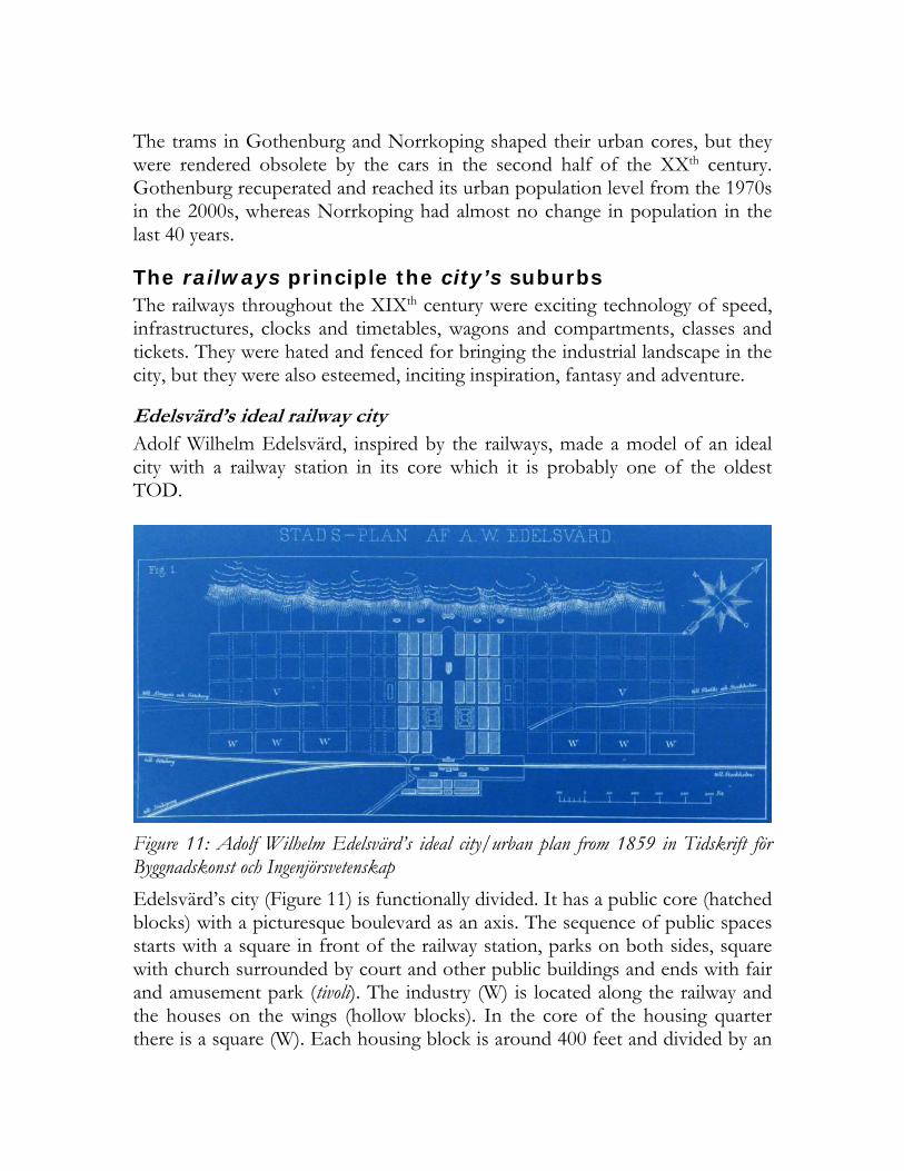
Edelsvärd’s ideal railway city Adolf Wilhelm Edelsvärd, inspired by the railways, made a model of an ideal city with a railway station in its core which it is probably one of the oldest TOD.
Figure 11: Adolf Wilhelm Edelsvärd’s ideal city/urban plan from 1859 in Tidskrift för Byggnadskonst och Ingenjörsvetenskap
Edelsvärd’s city (Figure 11) is functionally divided. It has a public core (hatched blocks) with a picturesque boulevard as an axis. The sequence of public spaces starts with a square in front of the railway station, parks on both sides, square with church surrounded by court and other public buildings and ends with fair and amusement park (tivoli). The industry (W) is located along the railway and the houses on the wings (hollow blocks). In the core of the housing quarter there is a square (W). Each housing block is around 400 feet and divided by an

alley. There are 12 houses in each block and the building coverage of the plots is 30-40%, while the rest is used for gardening, reflecting the picturesque and naturalism of the industrialization period.
The railway suburbs in Stockholm The suburbanization of Stockholm started in the 1890s and was facilitated by the prolonged urban tramways and new railways. The entrepreneurs quickly understood that railways dramatically increase land values and that garden suburbs are favoured and several companies competed to lay new railways and suburbs (see Svalhammer, 2008:57-8). They developed garden suburbs that achieved copious fame as cities of villas (villastäder) in Sweden.
Figure 12: A post card from Djursholm, the city of villas, station on Djursholmsbana, the luxurious interior of the train and finally the terminus in the city, from the end of the XIXth century (source: Stockholms Spårvägsmuseum/Stockholm Transport Museum)
There were two different models in Stockholm, sometimes the development and railway companies cooperated16 and sometimes there was only one
16 There was one company that planned suburbs along Djursholmsbana, which connected Djursholms in 1893, with a terminus on the north of the city.

company17 that both laid railways and developed land (ibid, 2008:43). By the 1930s there was already an array of radial railways with separated termini and suburban elongations or strings of pearls.
Stockholm’s tunnelbana and the ABC city The debate about Stockholm’s tunnelbana (metro) started in 191318 and the first tunnel opened in 1930s. The central station opened in 1957 networking the radial tramways and railways into a powerful metro system. Very few people can imagine Stockholm without its public transport hierarchy crowned by the tunnelbana, which successfully competes with the private car in the region.
Figure 13: Suburb as a pearl from Future Stockholm (Framtida Stockholm) in 1945(the numbers represent the favoured floor area ratios of the housing districts, whereas there is a horizontal mix of function (centre, school and sports) in the inner ring of the pearl with tangential industries) 17 Knut Agathon Wallenberg was a Swedish banker and politician that both financed the Sältsjöbana, which terminated in Slussen, and developed a string of suburbs eastward 18 In 1913 Knut Agathon Wallenberg opened the debate about a subway that will connect the radial railways and tramways. The subway was branded tunnelbana (railway in a tunnel) and the first tunnel opened in 1933 under the south island between Slussen and Skanstull. In the 1930s the politics changed favouring busses and metro over trams (see Svalhammer, 2008:78-92). The metro adopted the catchy brand tunnelbana.
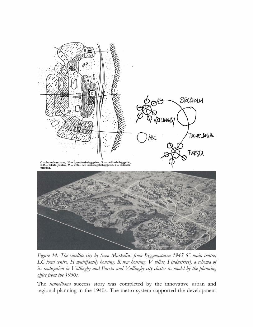
Figure 14: The satellite city by Sven Markelius from Byggmästaren 1945 (C main centre, LC local centre, H multifamily housing, R row housing, V villas, I industries), a schema of its realization in Vällingby and Farsta and Vällingby city cluster as model by the planning office from the 1950s.
The tunnelbana success story was completed by the innovative urban and regional planning in the 1940s. The metro system supported the development

of a system of suburbs and cities like pearls on a string designed by the ABC19 principle. The ABC principle was a Swedish response to the modernist functional city modified by the neighbourhood principle of functional containment that arrived with Lewis Mumford’s Culture of cities (Nyström and Lundström, 2004). The principle was actualized either as tunnelbana suburb or a satellite city, a cluster of suburbs. The tunnelbana suburb as a pearl (Figure 13), has varying radiuses and urban coefficients that should represent ‘a Stockholm in a miniature’ (1945:56) whereas the satellite city20 literally suburbanizes the suburbs by a hierarchy of centres (Figure 14). The high speed of the tunnelbana, concentration of centres and population around public transport nodes and the diversity of the ABC city balanced the public transport demand between the suburban pearls and the urban nucleuses and enabled wide public mobility. The tunnelbana is further supported by orbital urban and suburban blue bus lines and feeder reds.
Compact cities along light railways and busways as sustainable European cities The compact city is a contemporary sustainable reflection of the traditional dense and diverse European city. The urbanity is completed with an ambition is to make the private car an option, rather than a necessity (EC, 1990:30) by creating integrated, intermodal transport systems which fully exploit the potential of public transport (ibid., 1997:11-2). Stockholm and Gothenbourg have started experiments with sustainable neighbourhoods choosing light railways and busways as structuring urban elements, whereas Norrkoping extended its tramways in order to renew the neighbourhoods along.
Hammarby Sjöstad and the Tvärbana in Stockholm Hammarby sjöstad (translated as waterfront city) evolved in a sustainable city model in the 1990s. It fuses the traditional and ABC city in a compact unity along ideally sized light railway corridor. It has offices, shopping and even industry, but these varied functions are mainly put in different parts, whereas the buildings along the corridor have vertical mix of function as in the
19 The ABC city stands for arbete (working), bostad (housing) and centrum (centre) and is much inspired and critical to Le Corbusier’s urbanism and the functional city in CIAM’s Athens Charter. 20 Sven Markelius, the planning director in the city of Stockholm, in two articles (Markelius, 1945; 1956) argued for larger suburbs with at least 50000 inhabitants with various typologies to support the housing preferences. The satellite city of pearls was a response to that problem. Markelius planning office produced both the visionary overture Future Stockholm (Framtida Stockholm) and the unbinding Generalplan för Stockholm 1952, which shaped the ABC principle and what is Stockholm today.

historical core. The politicians wanted a true urban feel (stadsmässighet in Swedish) along the esplanade, as in the inner city. It is located south from the inner city district Södermalm and separated by a lake. The northern waterfront developed a pattern of quasi enclosed urban blocks in the early 1990s maximizing the lake views, which replicated on the southern waterfront.
Figure 15: Excerpt from the comprehensive plan for Stockholm from 1999 (the light railway, or Tvärbanan, with its stations is marked with red and the borders of Hammarby Sjöstad are with green line, is for metro or Tunnelbana, and is for railway Saltjöbana)
The winding green esplanade (marked with red on Figure 15) of the Tvärbana, the orbital light railway, is the backbone of the neighborhood. This 37 meter wide urban corridor collects pedestrians, bikers, trams, buses and cars in clearly defined linear stripes. The median tramway is partially separated from car traffic and fenced by longitudinal park. The bicycle lane is placed between the

car lane and a strip of on street parking. The sidewalks are the last stripe having direct contact with the commercial frontage of the buildings.
Figure 16: The waterfront and the tramway bridge, the pedestrian zone parallel to the main esplanade, the main esplanade and the Luma station on a square in Hammarby sjöstad
The city planning office wanted less private cars and high share of public transport and had heavy restrictions on parking places. The sustainable mobility measures were subverted by the development companies who had problems selling the apartments. Some apartments were sold in a package with a new car. The neighbourhood also attracted younger affluent families with high demand for mobility and wide accessibility and the slower light railways and the extra transfer seemed like a worse alternative then the car. The neighbourhood was not directly connected to the metro or railway lines, but the people needed to make transfer through an old greyish industrial area on the west which felt like leaving the city. To solve this problem the newest debate are about extension of the metro in Hammarby Sjöstad which will put the neighbourhood on the regional system map.

Norrkoping’s tramway extenstion in Hageby Norrkoping is one of only two Swedish cities, with Gothenburg, that have kept its tram system over the years. There are two tram and four urban bus lines in the city and the trams handle almost half of all the passengers that use the urban public transport. The city opened a 4 km extension of the tramway to the southern suburbs of Ljura, Hageby and Navestad in 2011. The extension should make these suburbs more attractive and sustainable and ispire new urban infill projects (the red buildings on Figure 18 and Figure 17). The tram extension connects Ljura, a housing area from the 1950s, Hageby Centrum, a 1960s shopping centre and terminates in Navestad, a housing area from the 1960s. Navestad has two housing complexes called Golden Ring and Silver Ring that were upgraded in the 1990s. To diversify Navestad, there are plans for more retail, housing and public spaces. The tramway extension will have 10 stops are laid on grass, which reduces noise. The simultaneous development along the tramway extension was the renovation of Hageby Centrum. New developments are expected in the following years.
Figure 17: The second stage of the tramway extension 2010-11

Figure 18: The first stage of the tramway extension 2009-10

Figure 19: The newly developed Hageby centre and the earlier developments around
Gothenburg’s busways in Norra Älvstranden Gothenburg and its region have been the industrial centre and largest port in Sweden since the mid 1900s when Götaverken, Lindholmen and Eriksberg, three of the world’s biggest shipyards opened on the north shore of Götälv (the wide river that separated the city from the industrial zone). The manufacturing power further strengthened when Volvo formed on the end of the 1920s. But since the 1970s, Gothenburg suffered from deindustrialization that heavily hit the northern industrial waterfront. The industrial area gradually emptied and the city assigned the northern waterfront (Norra Älvstranden), between the Götälv Bridge in the East and Älvsborgs Bridge in the west, for development. Large portion of the land is owned by the city and the renewal started in the 1990s with quite heterogeneous and fragmented developments. Eriksberg, an early development, much like the northern waterfront opposite of Hammarby Sjöstad displays a pattern of quasi enclosed urban blocks opening prospects on Götaälv, still closing up towards the streets to achieve an urban feeling. The more recent developments show less urban attitude, using more building typologies associated with the modernist era, but still focusing on maximizing water views.

Göteborg kept and carefully developed its tramway system in the city limits from 1879, but there was no agreement of a tram extension along the waterfront. Instead, the city and the public transport authority decided for a system of busways adopting the motto ‘think railways, run buses’, which also influenced the emergence of blue buses in Stockholm. The busways in Gothenburg however on some parts have been developed on a grand manner and served by double articulated buses. Lindholmsallén (Lindholm’s esplanade) is extremely wide (almost 90 meters), including separate bus lanes in the middle, a wide longitudinal park with double tree lines, double car lanes, another green stripe, single tree line, two-way bicycle lane and a separate sidewalk. The urban development is slow, but ongoing. It is located mainly on the waterfront. The dense development around public transport nodes is yet to come in this part of the Norra Älvstranden. The esplanade today feels very open and empty.
Figure 20: The busway and station in Lindholmen and the new developments along

The waterfront is also served by a Älvsnabben (River quick). It is a popular ferry line within the public transport system, connecting five stops on the northern and two on the southern (city centre). Two departures per hour in rush-hours is not very much, but it is about to increase in the near future. The Älvsnabbare (“river Quicker”) shuttle is, as its name suggests, a quicker shuttle line connecting Lindholmen on the north shore to Rosenlund on the southern shore – each sixth minutes in rush-hours. Since spring 2011, travelling with Älvsnabbare is free of charge. Similar ferry line free of charge exists in Hammarby Sjöstad, which was introduced instead of a bridge between the southern and northern waterfront.
Placemaking, light railways and TODs Every age produces its own expression that imprints on the cities. There are visionary models, housing preferences, bureaucratic constrains and developer practices that transmit replications of neighbourhoods, even on a global scale. In Sweden, especially in Stockholm, there is a tradition to use neighbourhood typologies to capture these consistencies. Each type reflects distinctive age and urban morphology. The sustainable neighbourhoods, TODs or compact suburbs in Stockholm and Gothenburg are regarded as newer urban enclaves (nyare stadsenklav). They are characterized by design and planning tradeoffs, containment, quasi enclosed urban blocks and quasi rectangular street network that is pierced by a dominant partially separated light railways (in Stockholm or Norrkoping) or light busway (in Gothenburg). The traditional European enclosed urban block is modified to allow vistas, since they are often waterfront developments. The light railways or busway is also partly barrier, partly permeable. They are suburbs or located on the fringes and have ambitions to be urban. Françoise Choay argues that planning includes rules and models21. When we discuss sustainable neighbourhoods and TODs, seems that the models prevail and we can see replication of similar neighbourhoods in Germany, Holland, France, Sweden and Great Britain. The question is did the European sustainable neighbourhood become stereotypical? We show in this paper that there are many models. There is a long history and tradition of integration of public transport in urban and regional planning and some old models worked fine. Stockholm is an example of where the public transport seeks regional and urban travel patterns with metro, suburban and urban buses. It is not always necessary to have one choice and once system, which can be replicated. The 21 The rules are procedures, operator, for conceiving and generating space and models are prototypes, a model space or a model of space (Choay, 1997:145).

hybrid public transport systems like light railways with wide infrastructural coverage have to be compared with combinations of innovative, old or new public transport systems that excel in urbanity and mobility, on urban or regional perspective. The other question is do we have to think in models? Sustainability deals with practices, flexibility and rules, rather then blueprints. Placemaking is about communities and processes, not about completed models. Edelsvärd in his ideal city (Figure 11) leaves empty blocks to be used in the future. Today we still tend to think in finished models that end in multiple replications. When Hammarby Sjöstad in Stockholm was finished there was no room for adjustments and transformations.
Figure 21: The vibrant urban life and a tram stop in the Pearl District and newly developed South Waterfront and the Portland Streetcars terminus
The development of Pearl District in Portland is an example with proactive planning, action plans and community involvement, instead of models. By living, planning and designing together the community enjoys its urbanity and diversity today. In this ongoing urban process the neighbourhood and public transport entangled together and the Portland Streetcar became a driver for development. Namely in 10 years there has been $3.5 billion investment along the line. But urbanity can evade TOD and the urban public transport systems
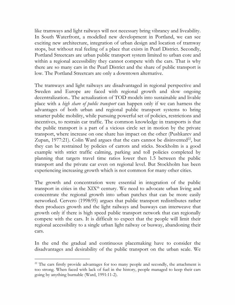
like tramways and light railways will not necessary bring vibrancy and liveability. In South Waterfront, a modelled new development in Portland, we can see exciting new architecture, integration of urban design and location of tramway stops, but without real feeling of a place that exists in Pearl District. Secondly, Portland Streetcars are urban public transport system limited to urban core and within a regional accessibility they cannot compete with the cars. That is why there are so many cars in the Pearl District and the share of public transport is low. The Portland Streetcars are only a downtown alternative. The tramways and light railways are disadvantaged in regional perspective and Sweden and Europe are faced with regional growth and slow ongoing decentralization.. The actualization of TOD models into sustainable and livable place with a high share of public transport can happen only if we can harness the advantages of both urban and regional public transport systems to bring smarter public mobility, while pursuing powerful set of policies, restrictions and incentives, to restrain car traffic. The common knowledge in transports is that the public transport is a part of a vicious circle set in motion by the private transport, where increase on one share has impact on the other (Pushkarev and Zupan, 1977:21). Colin Ward argues that the cars cannot be disinvented22, but they can be restrained by policies of carrots and sticks. Stockholm is a good example with strict traffic calming, parking and toll policies completed by planning that targets travel time ratios lower then 1.5 between the public transport and the private car even on regional level. But Stockholm has been experiencing increasing growth which is not common for many other cities. The growth and concentration were essential in integration of the public transport in cities in the XIXth century. We need to advocate urban living and concentrate the regional growth into urban patches that can be more easily networked. Cervero (1998:95) argues that public transport redistributes rather then produces growth and the light railways and busways can interweave that growth only if there is high speed public transport network that can regionally compete with the cars. It is difficult to expect that the people will limit their regional accessibility to a single urban light railway or busway, abandoning their cars. In the end the gradual and continuous placemaking have to consider the disadvantages and desirability of the public transport on the urban scale. We
22 The cars firstly provide advantages for too many people and secondly, the attachment is too strong. When faced with lack of fuel in the history, people managed to keep their cars going by anything burnable (Ward, 1991:11-2).

have to analyze permeability, nodal and linear attractiveness around stations and along lines and to choose smartly. These desirability cores can be urban catalysers, inducers and drivers for urban development around.
References Burgess, Ernest Watson, Park, Robert Ezra and McKenzie, Roderick. (1925). The city. University of Chicago Press: Chicago.
Calthorpe, Peter. (1993) The next American metropolis. Princeton Architectural Press: Princeton.
Cervero, Robert. (1998) The transit metropolis: a global inquiry. Island Press: Washington, DC. Choay, Françoise. (1969) The modern city: planning in the 19th century. George Braziller: New York
Choay, Françoise. (1997) The rule and the model: on the theory of architecture and urbanism. The MIT Press: Cambridge.
Clark, Colin. (1958) ‘Transport - Maker and breaker of cities’, Town planning review, Vol.28, No.4, 237-250.
Dennis, Kingsley and Urry, John. (2009) After the car. Polity Press: Cambridge.
Dunbar, Chris (1967) Buses, trolleys & trams. Bounty books: London.
Edelsvärd, Adolf Wilhelm. (1859) ‘Plan och byggnadssätt för landortsstäder och förstäder’, Tidskrift för Byggnadskonst och Ingenjörsvetenskap, No. 5, 65-9.
European Commission (EC). (1990) Green paper on the urban environment.
Hagson, Anders, and Mossfeldt, Lars. (2008) Analys av tillgänglighet, trafikarbete och färdmedelsval som funktion av väginvesteringar. Chalmers University of Technology: Gothenbourg.
Hall, Peter. (2002) Cities of tomorrow: an intellectual history of urban planning and design in the twentieth century, 3rd edition. Blackwell publishing: Malden.
Howard, Ebenezer. (1946) Garden cities of tomorrow. Faber and Faber: London.
Holmberg, Sten. (1958) Om bussrörelsen i Stockholm med omnejd. Aktiebolaget Stockholms Spårvägar: Stockholm.
Holmberg, Sten. (1960) Spårvägen i Stockholm : en minnesbok. Spårvägsmuseet: Stockholm.
Kostof, Spiro. (1991) The city shaped: urban patterns and meanings through history. Thames & Hudson: London.
Lindau, Luis Antonio, Hidalgo, Dario, and Facchini, Daniela. (2010). ‘Bus rapid transit in Curitiba, Brazil: a look at the outcome after 35 years of bus-oriented

development’, Transportation Research Record: Journal of the Transportation Research Board, No. 2193, 17–27.
Levinson, Herbert, Zimmerman, Samuel, Clinger, Jennifer, and Rutherford, Scott. (2002) ‘Bus Rapid Transit: An Overview’, Journal of Public Transportation, Vol. 5, No. 2, 1-30.
Markelius, Sven. (1945) ‘Stadsplanefrågor i Stockholm’, Byggmästaren 1945, 343-59.
Markelius, Sven. (1956) ‘Stockholms struktur: synpunkter på ett storstadsproblem’, Byggmästaren 1956, 49-76.
Miller, John Anderson. (1941:16-9) Fares, please! From horse-car to streamlines. D. Appleton-Century Company: New York.
Mumford, Lewis. (1938) The culture of cities. Harcourt, Brace and Company: New York.
Nyström, Louise and Lundstörm, Mats Johan (2006) ‘The life and death and life of great neighbourhood centres’, Built Environment, Vol. 32, No. 1, 32-52
Pushkarev, Boris and Zupan, Jeffrey. (1977) Public transportation and land use policy. Indiana University Press: Bloomington.
Svalhammer, Stig. (2008) I väntan på tunnelbanan: kollektivtrafikutbyggnad och bebyggelseexploatering i Stockholm. Stockholmia förlag: Stockholm.
Von Thunen, Johann Heinrich. (1966) Von Thunen’s Isolated State. Pergamon Press: Oxford.
Vuchic, Vukan. (2007) Urban transit systems and technology. John Wiley & Sons: Hoboken.
Ward, Colin. (1991) Freedom to go: after the motor age. Freedom press: London