· TOD. 203. Corridor Planning. Site/Project Scale • Design of streets • Design of buildings • Design of public spaces. Individual buildings and developments turn the principles
• Scales of TOD • The Transit Corridor• Types of Corridors• Objectives and
Strategies for Transit and TOD at the Corridor Level
Corridor Planning and TOD
TOD
203
Your Trainers Today
• Catherine Cox Blair• Kelley Britt
TOD
203 Corridor Planning and TOD
Transit-Oriented Development or TOD
People within a half-mile radius are 5 times as likely to walk to a major transit stop than others. Those who live further from a transit node are less likely to bother with the train or bus.
TOD also applies at the station, corridor and regional scales.
TOD = A Walkable Neighborhood
Presenter
Presentation Notes
Some transit agencies report people routinely walking as much as a half-mile for access, but a quarter mile is a good rule of thumb.
TOD
203 Corridor Planning and TOD
TOD: What it is not• "One size fits all"• Only high density housing• A single project• Fixed-guideway only• Only targeted to certain
market segments• Disruptive of existing
historic centers
NEED NEW PICSAn IsolatedProject near transit.
Presenter
Presentation Notes
SOURCE -Smart Growth America pic
TOD
203 Corridor Planning and TOD
Planning for TOD at Four Scales:
• Site • Station• Corridor• Region
TOD
203 Corridor Planning
Site/Project Scale• Design of streets • Design of buildings• Design of public spaces
Presenter
Presentation Notes
Individual buildings and developments turn the principles of transit-oriented development into physical reality. The design of streets and buildings can have a large impact on the types of transportation choices people make. When buildings are designed to take advantage of walking and transit, with active ground-floor uses and high-quality materials, they encourage increased walking, biking, and transit, and contribute to neighborhood vitality. When streets are designed to safely balance the needs of all users, it becomes easier for people to take care of their daily needs using transit. Public spaces, too, can provide important community gathering places and centers for activity.
Corridor Planning and TOD
TOD
203
Station Scale
• The Station Area generally refers to the ½ mile radius around the station.
San Leandro BART Station
½ mile radius
Presenter
Presentation Notes
Planning for TOD at the station area scale should aim to ensure that the 1/2-mile radius around a transit node contains a mix of uses and supports transit access and ridership. Planning at this scale should take into account the existing neighborhoods, since there are no one-size-fits-all solutions to TOD. Some neighborhoods may have good opportunities to grow neighborhood buying power through high-density, mixed-use development, while other neighborhoods may have more potential to take advantage of transit through street and roadway improvements.
TOD
203 Corridor Planning
Corridor Scale• In regions just starting to build their transit
network, choosing the “right” corridor to construct first can foster regional support and momentum for transit and TOD.
Presenter
Presentation Notes
The stations along a transit corridor support diverse and complementary transit-oriented neighborhoods. As connections between adjacent station areas are strengthened through transit, the amenities and opportunities in one area are made more accessible to others. Effective, integrated corridor-level planning can encourage the momentum of market activity between station areas, thus augmenting and diversifying development and other opportunities.
TOD
203 Corridor Planning and TOD
What is a Transit Corridor?
• A transit corridor is defined as the walkable areas around all of the stations along a transit line.
• The line segment connects a series of “station areas”
• Station areas are the walkable, half-mile radius around each station
Presenter
Presentation Notes
What is a transit corridor? It is a transit line or a line segment that connects places that have a relationship to each other; these are known as origins, such as residential areas, and destinations, such as places with jobs or entertainment. Corridors consist of a series of “station areas” – the walkable area around each station, usually defined as a half mile.
TOD
203 Corridor Planning and TOD
Regions Are Networks of Corridors
Presenter
Presentation Notes
Multiple corridors in a city or region create a network of transit-oriented places and sites that integrate different functions and activity centers within easy access of transit. Planning at the regional scale can address problems such as need to connect job centers and the goal of providing disadvantaged communities to improved access to employment and retail opportunities. It is at this scale that overall mode shares and the health of a transit network can be most influenced.
Corridor Planning and TOD
TOD
203
What are the Benefits of Corridor Planning?
• Integrates both regional and local contexts
• Transit becomes the organizing principle for development
• Engages a wide range of stakeholders
• Transit changes market dynamics by providing new access
• Corridors become the network of regions
• Prioritizes high-potential station areas for development and investment
Presenter
Presentation Notes
There are many benefits to planning at the corridor level, including providing important context for understanding the role of each station area in the corridor and the likely impacts of transit. This assists in understanding development potential, as well as appropriate land uses and densities at each station area. Station areas can therefore be prioritized for development or public investment. It also helps to clarify the roles (and/or goals) of the corridor within the regional network. Finally, corridor-level analysis also opens up the potential for conversations that go beyond individual neighborhood interests and instead focus on the regional benefits of connecting transit and land use decision-making.
TOD
203 Corridor Planning and TOD
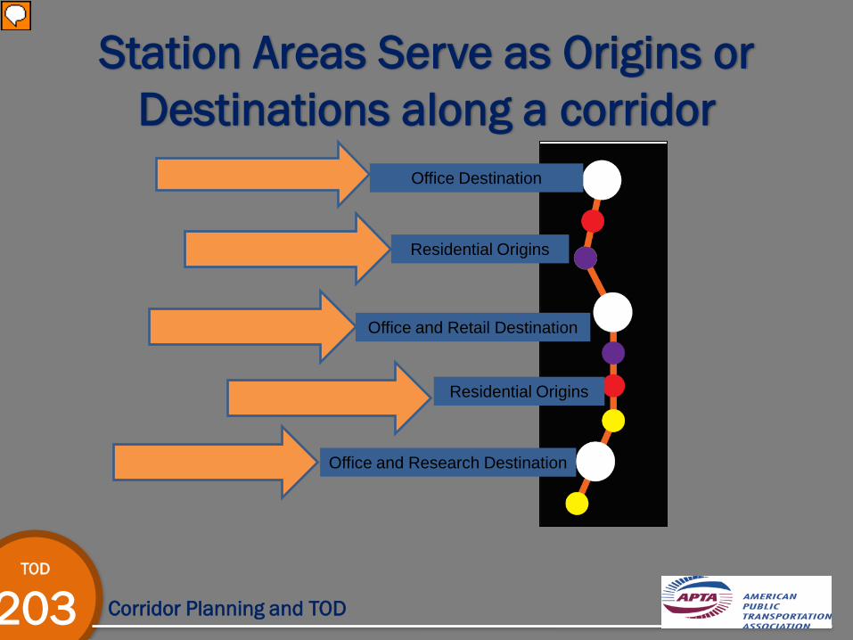
Office Destination
Residential Origins
Office and Retail Destination
Office and Research Destination
Residential Origins
Station Areas Serve as Origins or Destinations along a corridor
Presenter
Presentation Notes
Station areas play different roles within the corridor and region depending on each area’s land use patterns and relationship to other station areas. Some are primarily origins, some are destinations, and some are both.
TOD
203 Corridor Planning
Three Basic Corridor Types
Commuter
District Circulator
DestinationConnection
Presenter
Presentation Notes
We usually define corridor types according to the mix of origins and destinations. Commuter corridors link a series of residential origins to a work destination. A district circulator, such as Portland’s streetcar, is designed to facilitate movement within an activity node – often a downtown. A destination connection corridor links a series of origins and destinations. An example is the Hiawatha line in Minneapolis, which connects a series of destinations, including downtown Minneapolis, the Minneapolis airport, and the Mall of America.
Corridor Planning and TOD
TOD
203
Corridor Type 1Destination Connector
• Links residential neighborhoods to multiple activity centers
• Encourages ridership in both directions and picks up off-peak riders
• Example: Kansas City BRT Line
Corridor Planning and TOD
TOD
203
Destination ConnectorCase Study: Kansas City, MO
• “Connector Line”• Connects most of the
highly populated districts in the city
• Will connect to new BRT Line, future light rail and streetcar projects
• Potential for future TOD investment along the corridor
Crown Center
Union Station
Presenter
Presentation Notes
The Smart Moves plan advances a 12-year comprehensive plan for transit service to the Kansas City metropolitan area, including express service on bus rapid transit and commuter rail (Rapid Riders), local buses and trolleys that feed into the express service (Local Links), and express buses on the highways (Freeway Flyers). SOURCES http://www.kcata.org/light_rail_max/max_and_bus_rapid_transit/ - Photo and content source netdensity.net/.../2009/12/KCMAX_Station.jpg – Photo source www.fta.dot.gov/TRO_7/KCATA_UnionStationStop_.. - Photo source http://images.broadwayworld.com/columnpic2/Retail-dusk.jpg – Photo source
Corridor Planning and TOD
TOD
203
Corridor Type 2Commuter
• Mainly serves one activity center which is typically the CBD.
• Riders are coming into the CBD for both works trips
• High ridership usually takes place during peak hours
Corridor Planning and TOD
TOD
203
Commuter BRTEugene, OR
• Emerald Express (EmX)• 10 stops• 4 mile route that
connects downtown Eugene to downtown Springfield
• Over 4,700 riders daily
Presenter
Presentation Notes
1. 4 miles from downtown Eugene to downtown Springfield with two and a half miles in exclusive bus-only lanes, signal priority, 10 stops 2. Custom-designed hybrid-electric vehicles, raised boarding platforms 3. Connects the Eugene and Springfield regional area 4. Ridership increased over 50% to 4,700 riders daily SOURCE http://pedshed.net/?p=61 – photo source http://www.gobrt.org/Eugene.html – photo and content source
Corridor Planning and TOD
TOD
203
Corridor Type 3District Circulator
• Facilitate movement within an activity node
• Usually “circles” around downtown, a medical or educational center
• Typically a circulator, streetcar or high frequency bus
Corridor Planning and TOD
TOD
203
District CirculatorMemphis, TN
• Connects most downtown major attractions
• 3 Trolley car system– Main Street Trolley– Riverfront Loop Trolley– Madison Ave Trolley
Presenter
Presentation Notes
The Main Street Trolley follows the path of its mule-drawn predecessor, runs along Main Street from Auction Avenue to G.E. Patterson Ave. The Riverfront Loop Trolley's 2.5-mile route offers outstanding views of the Mississippi River. The Madison Avenue trolley line gives riders access to Midtown and medical facilities. The Main Street Trolley operates along the beautifully updated Main Street Mall and serves many downtown landmarks. The famous Pinch District, Cook Convention Center, Civic Center Plaza, Court Square, Peabody Place, Beale Street, National Civil Rights Museum, FedEx Forum and the South Main Historic Arts District can all be easily accessed by the Main Street Trolley. Riders can take the Riverfront Loop Trolley to visit the Tennessee Welcome Center, the grounds of the Pyramid Arena and Mud Island with its Mud Island Monorail, the 5-block long River Walk, and the Mississippi River Museum. The Madison Avenue line features public art at each trolley station along the route. Each of the six artworks - which range from mosaic murals to sculptures - are designed to reflect the community in which the transit station is located.
Corridor Planning and TOD
TOD
203
What are the Benefits of Planning at the Corridor Level?
• Explains station area roles within the corridor and maximizes the benefits generated by connectivity and greater mobility choices
• Integrates the regional and local contexts
• Creates momentum for TOD implementation
• Increases efficiency
Presenter
Presentation Notes
There are many benefits to planning at the corridor level, including providing important context for understanding the role of each station area in the corridor and the likely impacts of transit. When planning only at the local level or station area, the broader context of the region is not always taken into consideration. Planning and implementing TOD requires the significant investment of public and private resources. Corridor Planning for TOD allows public agencies to phase this investment over time, beginning with stations that have higher potential for TOD in the short term and can activate the market.
TOD
203 Corridor Planning
Objectives for Transit and TOD at the Corridor Level
1. Guide growth and development2. Support regional economic growth3. Enhance regional and local equity4. Promote reinvestment and increase spending
power5. Invigorate stakeholder engagement and
collaboration6. Maximize TOD potential and benefits
Presenter
Presentation Notes
These objectives will be followed by a suggested strategy to use in order to obtain the objective. TOD corridor planning may only focus on a few objectives at a time, depending on the type of corridor, it’s specific characteristics, and the goals of corridor stakeholders.
Corridor Planning and TOD
TOD
203
Guide Growth and Development
• The corridor planning process can help identify where new development might occur.
• Transit alone does not create a new market for development.
• Strategy: Understand the potential market reaction to transit.
• Transit can influence the market by:– Improving access to key
destinations– Nudging the market from
stations with pent up demand to lower demanding stations
Presenter
Presentation Notes
Transit corridors that connect activity centers to station areas with significant development opportunities are most likely to see significant new development.
TOD
203 Corridor Planning and TOD
Guide Growth and DevelopmentCase Study: Charlotte, NC
• New light rail line introduced in 2007
• Connects the city center to suburban Pineville– Links urban and suburban
communities to city center• Major Functions:
– Future growth and development (infill)
– Economic development
Source: Mecklenberg County, 2006, Center for TOD
Presenter
Presentation Notes
The first example is from Charlotte, North Carolina. -The nine mile Blue Line light rail line opened in 2007, connecting the city center to suburban Pineville. -Primarily a commuter corridor, as downtown Charlotte (known locally as “Uptown”) is the largest employment destination along the line, with most other stops consisting primarily of urban and suburban residential areas. -Regardless of original intent, the Blue Line wound up serving two major functions: first, it focuses future growth and development within infill locations close to the city center. Second, the line has arguably played an important role in promoting economic development in Uptown Charlotte itself.
Corridor Planning and TOD
TOD
203
Support Regional Growth
• Transit corridors can support continued economic growth by offering alternatives to driving and improved connections to jobs and other destinations.
• Strategy: Connect residents to activity center with transit– Align new transit
corridors with existing travel patterns
– Connecting regional destinations
Corridor Planning and TOD
TOD
203
Support Regional GrowthCase Study: Seattle Streetcar
• South Lake Union Line• 2.9 mile street car
corridor• Connects
neighborhood residents to downtown
• Connects to bus and light rail system that goes other regional destinations
Presenter
Presentation Notes
Seattle’s South Union streetcar didn’t start operations until late 2007, but property owners and employers understood early on the benefits the streetcar would provide by linking the South Lake Union and Denny neighborhoods with downtown Seattle. That’s why property owners along the line paid for more than half its $52 million dollar price tag, and major employers including several medical and educational institutions, became official streetcar sponsors. Both Amazon.com and the non-profit Group Health Collaborative moved their headquarters to the South Lake Union neighborhood, believing it would be a real benefit for employees to be able to make quick trips via streetcar to business meetings or lunch downtown, or to the nearby light rail station to catch a train to the airport.
Corridor Planning and TOD
TOD
203
Increase Regional and Local Equity
• Connect lower-income neighborhoods to job centers to enhance equity
• Access to regional centers by transit lowers transportation costs and increases spending power
• Strategy: Develop a mixed-income TOD strategy– Existing affordable
housing should be preserved
– Target resources toward new affordable housing
TOD
203 Corridor Planning and TOD
Increase Regional and Local EquityCase Study: Central Corridor
Presenter
Presentation Notes
Case Study: The Central Corridor in Minneapolis, scheduled to open in 2014, will connect downtown Minneapolis with the University of Minnesota and downtown Saint Paul. By 2010, 40 planning projects had been completed for neighborhoods and stations along the corridor, and more than 500 improvements had been identified. Identifying all the potential public investments and understanding how they might affect private investment was the first step in prioritizing projects along the corridor, thereby creating a public investment strategy as well as a more predictable environment for private investment .
Corridor Planning and TOD
TOD
203
Promote Reinvestment and Increase Spending Power
• Leverage significant economic development and investment along older corridors
• Allows residents to have local spending power
• Strategy: Create an economic revitalization policy– Local-hire requirements– Tax breaks and other
incentives– Shared parking or other
strategies
Corridor Planning and TOD
TOD
203
Promote Reinvestment and Increase Spending Power
Case Study: Euclid Corridor• 6.8 mile BRT corridor
that connects downtown to first inner ring suburb
• Connects resident to employment destinations
• 4.3 billion of new and/or infill private development in along the corridor
Presenter
Presentation Notes
The Cleveland Clinic and University Hospitals championed the city’s new bus rapid transit line along historic Euclid Avenue and helped brand it as the Health Line. The Greater Cleveland Regional Transit Authority planted 1,500 trees along the route, and partnered with city staff and local development corporations to promote development including both market-rate and affordable housing. By 2010 more than $4.3 billion had been invested in neighborhoods along the line. East 4th St is one of many examples of the resulting redevelopment. Formerly an alleyway, it has been transformed with overhead strands of lights, patio dining, plantings, art, awnings and neon, and has become a thriving pedestrian-oriented restaurant and residential center.
Corridor Planning and TOD
TOD
203
Invigorate Stakeholder Engagement and Collaboration
• Transit agencies and city planners are the key actors in TOD planning and implementation.
• Utilizing corridor planning widens the spectrum of stakeholders and requires greater buy-in
engagement will depend on the objectives set forth in the planning process
Corridor Planning and TOD
TOD
203
Invigorate Stakeholder Engagement and Collaboration
Case Study: West Corridor
Presenter
Presentation Notes
Case Study: The West Corridor in Denver, which opens in 2013, will connect downtown to job centers in the western suburbs of Lakewood and Golden. This corridor travels through lower-income neighborhoods with a lot of rental housing, including three major public housing developments within a half mile of stations. The existing demographic and housing conditions of the corridor make many communities susceptible to displacement. Planning for equitable TOD along this corridor has been a collaborative effort led by the housing authorities and planning agencies in two cities. This planning effort has identified the stations that need attention in the short term, as well as a longer-term strategy to guide corridor-wide development.
Corridor Planning and TOD
TOD
203
Maximize TOD Potential and Benefits
• New transit corridor requires public and private investment
• Identify where and when to invest public dollars to ensure local goals
• Strategy: Establish a phased TOD implementation and investment plan– Prioritize stations areas
for investment– Investment framework
should be created to utilize data on existing conditions and coordination
Corridor Planning and TOD
TOD
203
Maximize TOD Potential and BenefitsCase Study: Baltimore, MD
Presenter
Presentation Notes
In Baltimore a regional TOD implementation plan created a framework guide TOD investment, identifying stations as priorities for investment in the short, medium, or long term.
TOD
203 Corridor Planning
In Closing…• All scales of planning for TOD are important• Corridor planning typically begins when a
new transit investment is proposed• Corridor planning presents the opportunity to
engage stakeholders early in the process• Corridor planning is effective when it
involves planning for each station along the corridor as well as the role they play within the regional network
Presenter
Presentation Notes
In conclusion, there are three key takeaways from this presentation: -Analysis at the corridor level provides a broader perspective that shows how the regional, transit network, and corridor-wide markets affect the development potential and land uses at the individual station areas. -At the most basic level, station area planning first requires an understanding of the type of corridor on which the station are is located, and the major functions the corridor plays within the transit network. With that perspective, and an understanding of which stations are origins versus destinations, station-level planning will be more realistic about each station’s potential. -Finally, at the station area level itself, stations must be prioritized for investments and planning that will result in ideal outcomes: transit-oriented districts that maximize transit system use, reduce dependency on automobiles, and is at a scale appropriate to maximize market demand capture within the station area.